APPENDIX B. Hydrologic and Hydraulic Analysis
|
|
|
- Whitney Moore
- 5 years ago
- Views:
Transcription
1 APPENDIX B Hydrologic and Hydraulic Analysis
2 HYDROLOGIC AND HYDRAULIC ANALYSIS PETERSBURG ROAD IMPROVEMENTS DOT&PF Project No Prepared for: State of Alaska Department of Transportation and Public Facilities Southeast Region 6860 Glacier Highway Juneau, Alaska (907) Prepared by: DOWL HKM 4041 B Street Anchorage, Alaska (907) W.O. D70212 September 2010
3 Hydrologic and Hydraulic Analysis Petersburg, Alaska Petersburg Road Improvements DOT&PF Project No TABLE OF CONTENTS Page 1.0 INTRODUCTION Objective HYDROLOGIC ANALYSIS Drainage Area Characteristics Methodology Soil Conservation Service Graphical Peak Discharge Method Estimated Runoff HYDRAULIC ANALYSIS Existing Conditions Storm Drain Pipe Material RECOMMENDATIONS Storm Drain System Recommendations...9 FIGURES Figure 1: Drainage Basins...3 TABLES Table 1: Summary of Drainage Basin Areas...1 Table 2: Drainage Basin Runoff Summary...4 Table 3: Existing Storm Drain System Capacities...5 APPENDIX Appendix A... Runoff Computations LIST OF ACRONYMS cfs... cubic feet per second CMP... corrugated metal pipe CPEP... corrugated polyethylene pipe DOT&PF... State of Alaska Department of Transportation and Public Facilities GIS... Geographic Information System NRCS... Natural Resources Conservation Service RCN... runoff curve number SCS... Soil Conservation Service T c... time of concentration TR Technical Release 55: Urban Hydrology for Small Watersheds Page i
4 Hydrologic and Hydraulic Analysis Petersburg, Alaska Petersburg Road Improvements DOT&PF Project No INTRODUCTION 1.1 Objective The objective of this study is to determine the runoff quantities for 2-, 10-, and 25-year peak discharges draining to the downtown area in Petersburg, Alaska, to facilitate sizing of storm drain systems in support of roadway improvements. Hydrologic and hydraulic computations were performed to evaluate existing drainage infrastructure to determine whether capacity exists to effectively transport the 25-year peak flow and to determine appropriate sizing for locations where existing capacity is exceeded. This report is intended to specify sizing requirements for new storm drain systems to be incorporated into the Petersburg Road Improvements project and is not intended to provide specific locations of new drainage structures. Additional design will be required as utility improvements progress. 2.0 HYDROLOGIC ANALYSIS 2.1 Drainage Area Characteristics Ten drainage basins were defined in order to determine runoff for 2-, 10-, and 25-year storm events. The drainage basins were defined based upon existing topographic maps, Geographic Information System (GIS) data, survey information, and reconnaissance gathered during a site inspection conducted throughout A map of the drainage basins is presented in Figure 1. The basins are primarily located within developed regions of the City of Petersburg, with the upper boundary of one basin including undeveloped forested hillside. Table 1: Summary of Drainage Basin Areas Drainage Basin Area (acres) Table 1 lists the contributing size of each basin in acres. Typically, basins drain to the North Harbor in the Wrangell Narrows via several existing piped storm drain systems. Some basins drain to Hammer Slough near Nordic Street via sheet flow or piped storm drain systems. Hammer Slough drains to the Wrangell Narrows. Average slopes of drainage basins at and below Nordic Drive are typically in the range of 1% to 2%, while basins above Nordic Drive are much steeper with slopes as high as 25%. Page 1
5 Hydrologic and Hydraulic Analysis Petersburg, Alaska Petersburg Road Improvements DOT&PF Project No Methodology Hydrologic analyses were performed to determine peak flows for the design recurrence intervals. The 25-year, 24-hour design flows determine the required capacity of the storm drain systems in order to appropriately contain peak flows as typically required by the State of Alaska Department of Transportation and Public Facilities (DOT&PF). The 2-year, 24-hour design flows provide the basis for determining appropriate water treatment measures for new storm drain systems. The 10-year, 24-hour runoff provides an intermediate flow used for evaluating existing storm drain systems and can potentially be used for sizing less critical storm drain systems. These calculated peak flows were used to evaluate existing drainage infrastructure for flood conveyance capacities. The hydrologic data for this study was computed using the Soil Conservation Service (SCS) Graphical Peak Discharge Method. The SCS Method is based upon the United States Department of Agriculture Natural Resources Conservation Service s (NRCS) Technical Release 55: Urban Hydrology for Small Watersheds (TR-55). 2.3 Soil Conservation Service Graphical Peak Discharge Method The SCS Method was applied to the ten basins in order to determine the peak flows for 2-, 10-, and 25-year runoff events. The input data required for the SCS Method includes the drainage areas, runoff curve numbers (RCN), the time of concentration (T c ) and the associated precipitation values. The precipitation values were acquired from 24-hour rainfall maps in SCS s Technical Publication No. 47. TR-55 specifies that Type I storm should be used for all of Alaska. However, the DOT&PF Highway Drainage Manual recommends using a Type IA storm for coastal regions of Alaska. This selection seems logical in this case as the coastal rainforest climate of Petersburg is more comparable to the coastal climate of Oregon and Washington (where Type IA storms are specified for use in TR-55) than to the interior regions of Alaska where Type I storms are specified. The SCS curve numbers are used to describe the surface characteristics of the drainage area and are based upon land cover and hydrologic soil type. Soils are grouped as Type A, B, C, or D based upon rates of hydraulic conductivity, where Group A soils have the most potential for infiltration and Group D soils have the least potential for infiltration. The NRCS does not have soil data readily available for this area. However, soil log data located through NRCS reports lists soils in the Petersburg area as being primarily Type B and C soils. For this analysis, it was Page 2
6 Drainage Basins Basin Acres La ke S tr e t th St reet Fram Street Gauffin Str eet Excel Str eet 7th St reet th St reet Kiseno Street t u e Ira II St reet e a tr Haugen Drive e A l as g S 8th St reet 5th St reet 5th St reet ng ra W 1 «0 4th St reet e nu ve la el 4th St reet 3r d Street 4 «Gjoa Stree t ug lo y 0 P:\Projects\J20212\GIS\Hydro\Drainage Basins.mxd Feet 300 Figure 1 Drainage Basins Lumbe r Stree troad Improvements Petersburg February 12, 2010 Pear l F Road Flow Direction Ne ptu ne St ree t Storm Drain ¹ gl ee Topo Lines Lan sin g St 7 «Sin Drainage Ditch le Al Ha rb o r Wa y 5 «8 «Kise n o St 9 «h Marian St Nordic Drive et ers 6 «re mm 3 «St ch Bi r Ha 1st Stre et Dolp hin Stre et Bald er Str eet 1 «2 «2nd Str eet
7 Hydrologic and Hydraulic Analysis Petersburg, Alaska Petersburg Road Improvements DOT&PF Project No decided to classify all of the soils as Type C in order to be conservative in determining peak runoff flows and to take into account the fact that disturbed soils typically result in higher runoff quantities than undisturbed soils. After determining the hydrologic soil type, the RCN is determined based upon the land cover. For this analysis, an RCN of 70 was selected to represent forested areas (woods, good condition), an RCN of 90 was selected to represent residential (1/8 acres lots) and commercial areas, and an RCN of 98 was selected to represent impervious areas, rooftops, and paved roads. The T c is the total time required for the runoff to flow from the most hydraulically remote point in the drainage basin to the point of investigation. Average basin slopes and flow lengths were determined for all ten basins based upon GIS data and topographical information. Slopes ranged from as low as 1% to 25%. The T c was obtained using procedures described in TR-55 for each basin. The total T c is the sum of the overland sheet flow, shallow concentrated flow and channel flow. The TR-55 computations for the SCS Method are included in Appendix A. 2.4 Estimated Runoff Results of the SCS Method for estimating runoff from the ten basins are presented in Table 2. Where assumptions were required regarding soil conditions, land cover and drainage structure conditions, conservative approximations were made to compute flow estimates. This includes using RCN numbers based on Type C soils, determining T c based on practical drainage paths using paved gutter flow, and assuming that existing storm drain systems are in good condition and at moderate slopes. Table 2: Drainage Basin Runoff Summary Drainage Basin Area (acre) Q 2yr,24hr (cfs) Q 10yr,24hr (cfs) Q 25yr,24hr (cfs) Page 4
8 Hydrologic and Hydraulic Analysis Petersburg, Alaska Petersburg Road Improvements DOT&PF Project No HYDRAULIC ANALYSIS 3.1 Existing Conditions The existing storm drain systems in the project area and surrounding vicinity are included in Figure 1. Locations and flow directions of the drainage systems were determined from GIS data, survey information, and field inspections. The full-flow capacity of existing storm drain systems was computed using Manning s equation without headwater or tailwater effects. Where pipe slopes were not known, slopes were assumed based on existing topography and similar piped systems. Slopes were assumed to match road slopes and to have similar slopes to those systems for which survey data was available. The existing storm drain systems analyzed in this study are presented in Table 3. The system capacity is compared to the estimated 25-year, 24-hour runoff from contributing drainage basins. Descriptions of the individual drainage basins follow. Table 3: Existing Storm Drain System Capacities Contributing Basin Pipe Description 24" CMP in Nordic Drive 24" CMP in Dolphin Street South of Nordic Drive 30" CMP in Excel Street 24" CMP in Fram Street 12" CMP in Gjoa Street at Harbor Way 24" CMP in Gjoa Street at Harbor Way 18" CMP in Harbor Way 18" CMP in Nordic Drive and Haugen Drive 12" CMP in Harbor Way 30" CMP in Haugen Drive Assumed Slope 8.0% 1.0% 1.1% 1.3% 1.0% 1.0% 1.5% 2.0% 1.0% 2.7% Discharge Point North Harbor North Harbor North Harbor North Harbor North Harbor North Harbor North Harbor Hammer Slough North Harbor Hammer Slough Q full (cfs) Q 10yr (cfs) Passes Q 10yr Q 25yr (cfs) Passes Q 25yr Yes 5.7 Yes Yes 10.6 Yes Yes 7.7 Yes No 17.6 No Yes 1.1 Yes Yes 6.1 Yes Yes 2.1 Yes Yes 1.7 Yes Yes 1.1 Yes No 55.1 No Page 5
9 Hydrologic and Hydraulic Analysis Petersburg, Alaska Petersburg Road Improvements DOT&PF Project No Basin 1 is 4.08 acres in size and encompasses the area from Balder Street west to the northern portion of Nordic Drive. Commercial development makes up the majority of the basin area. Runoff from this basin collects in a piped storm drain system located in Balder Street and Nordic Drive. The existing storm drain system consists of 18-inch corrugated metal pipe (CMP) in Balder Street and 24-inch CMP in Nordic Drive and drains to an outfall at the North Harbor west of Nordic Drive. The 2-year, 24-hour runoff for this basin is 3.1 cubic feet per second (cfs); the 10-year, 24-hour runoff is 4.7 cfs; and the 25-year, 24-hour runoff is 5.7 cfs. The 24-inch CMP in Nordic Drive has an estimated full-flow capacity of 34.7 cfs (at a slope of 8.0%) and is adequately sized for all analyzed storm recurrence intervals. The pipe slope and subsequent hydraulic capacity may decrease near the system outfall. This will need to be confirmed during the design process. Basin 2 is 7.57 acres in size and encompasses the area between Dolphin Street and Balder Street, including portions of Third Street, Second Street, First Street, and Nordic Drive. This basin consists primarily of commercial and residential properties. This basin drains through an 18- and 24-inch CMP system located in Dolphin Street and Nordic Drive before reaching an outfall at the North Harbor. The 2-year, 24-hour runoff for this basin is 5.8 cfs; the 10-year, 24-hour runoff is 8.6 cfs; and the 25-year, 24-hour runoff is 10.6 cfs. The 24-inch CMP in Dolphin Street has an estimated full-flow capacity of 12.3 cfs (at a slope of 1.0%) and is adequately sized for all analyzed storm recurrence intervals. Basin 3 is 5.52 acres in size and includes the area between Excel Street and Dolphin Street from approximately Third Street west to Nordic Drive and the north end of Harbor Way. The basin consists of commercial and residential developments. Runoff from Basin 3 drains via gutter and ditch flow to a piped storm drain system located in Excel Street. The system consists primarily of 30-inch CMP pipes and drains to an outfall at the North Harbor at the intersection of Excel Street and Harbor Way. The 2-year, 24-hour runoff for this basin is 4.2 cfs; the 10-year, 24-hour runoff is 6.3 cfs; and the 25-year, 24-hour runoff is 7.7 cfs. The 30-inch CMP in Excel Street has an estimated full-flow capacity of 23.3 cfs (at a slope of 1.1%) and is adequately sized for all analyzed storm recurrence intervals. Page 6
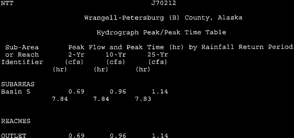
10 Hydrologic and Hydraulic Analysis Petersburg, Alaska Petersburg Road Improvements DOT&PF Project No Basin 4 is acres in size and encompasses the area between Fram Street and Excel Street from approximately Fourth Street to Harbor Way, including a portion north of Excel Street from Third Street to Fifth Street. This is a developed area consisting of residential and commercial properties. This basin drains via ditch flow to Fram Street, where runoff collects in a piped storm drain system consisting of 18- and 24-inch CMP. Runoff flows through the 24-inch CMP to an outfall at the intersection of Fram Street and Harbor Way. The 2-year, 24-hour runoff for this basin is 10.2 cfs; the 10-year, 24-hour runoff is 14.7 cfs; and the 25-year, 24-hour runoff is 17.6 cfs. The 24-inch CMP in Fram Street has an estimated full-flow capacity of 14.0 cfs (at a slope of 1.3%) and is undersized for the 10- and 25-year storm events. Basin 5 is 0.73 acres in size and includes the area encompassing Gjoa Street between Nordic Drive and Harbor Way. This basin consists of impervious areas (roadways, roofs, etc) and drains to a piped storm drain system in Gjoa Street and Harbor Way. The pipes in this system are 12-inch CMP and drain to an outfall at the North Harbor. The 2-year, 24-hour runoff for this basin is 0.7 cfs; the 10-year, 24-hour runoff is 1.0 cfs; and the 25-year, 24-hour runoff is 1.1 cfs. The 12-inch CMP system in Basin 5 has an estimated full-flow capacity of 2.2 cfs (at a slope of 1.0%) and has sufficient capacity for all analyzed storm recurrence intervals. Basin 6 is 4.34 acres in size and is encompasses an area around Gjoa Street from Second Street to Sing Lee Alley. The basin includes residential and commercial development. The basin drains to a piped storm drain system comprised of 18- and 24-inch CMP in Gjoa Street draining to an outfall at the North Harbor. The piped storm drain system from Basin 6 drains though Basin 5 to an outfall adjacent to the outfall from Basin 5. The 2-year, 24-hour runoff for this basin is 3.3 cfs; the 10-year, 24-hour runoff is 5.0 cfs; and the 25-year, 24-hour runoff is 6.1 cfs. The 24-inch CMP in Gjoa Street has an estimated full-flow capacity of 12.3 cfs (at a slope of 1.0%) and has sufficient capacity for all analyzed storm recurrence intervals. Basin 7 is 1.34 acres in size and is located west of Nordic Drive at the harbor, including a portion of Sing Lee Alley and Harbor Way. This basin consists almost entirely of impervious area. Runoff from this basin collects in a piped storm drain system in Harbor Way consisting of 18-inch CMP draining to an outfall at the North Harbor. The 2-year, 24-hour runoff for this basin is 1.3 cfs; the 10-year, 24-hour runoff is 1.8 cfs; and the 25-year, 24-hour runoff is 2.1 cfs. Page 7
11 Hydrologic and Hydraulic Analysis Petersburg, Alaska Petersburg Road Improvements DOT&PF Project No The 18-inch CMP has an estimated full-flow capacity of 7.0 cfs (at a slope of 1.5%) and is adequately sized for all analyzed storm recurrence intervals. Basin 8 is 1.09 acres in size and encompasses an around surrounding the intersection of Haugen Drive and Nordic Drive. The area is impervious and drains through a piped storm drain system consisting of 18-inch CMP to an outfall at Hammer Slough, located west of downtown Petersburg. The 2-year, 24-hour runoff for this basin is 1.0 cfs; the 10-year, 24-hour runoff is 1.4 cfs; and the 25-year, 24-hour runoff is 1.7 cfs. The 18-inch CMP has an estimated full-flow capacity of 8.1 cfs (at a slope of 2.0%) and is adequately sized for all analyzed storm recurrence intervals. Basin 9 is 0.71 acres in size and includes the area encompassing the north portion of Harbor Way. This area is impervious and drains through a piped storm drain system consisting of 12-inch CMP to an outfall at the North Harbor, located west of downtown Petersburg. The 2-year, 24-hour runoff for this is 0.7 cfs; the 10-year, 24-hour runoff is 0.9 cfs; and the 25-year, 24-hour runoff is 1.1 cfs. The 12-inch CMP system in Basin 9 has an estimated full-flow capacity of 2.2 cfs (at a slope of 1.0%) and has sufficient capacity for all analyzed storm recurrence intervals. Basin 10 is acres in size and encompasses a large portion of the east side of downtown Petersburg, including the area spanning from approximately Kiseno Street to Fram Street between Second and Eighth Streets. Basin 10 consists primarily of developed residential areas, with some undeveloped forested areas present in the northeast portion of the basin. The basin drains via a network of road-side drainage ditches to a piped storm drain system in Haugen Drive. The piped storm drain system includes segments of 18-, 24-, and 30-inch CMP. From the intersection of Haugen Drive and First Street, the system drains south through 30-inch CMP to an outfall at Hammer Slough. The 2-year, 24-hour runoff for this basin is 27.0 cfs; the 10-year, 24-hour runoff is 42.7 cfs; and the 25-year, 24-hour runoff is 53.3 cfs. The 30-inch CMP has an estimated full-flow capacity of 35.1 cfs (at a slope of 2.5%) and is undersized for the 10- and 25-year storm events. Page 8
12 Hydrologic and Hydraulic Analysis Petersburg, Alaska Petersburg Road Improvements DOT&PF Project No Storm Drain Pipe Material All existing storm drain systems within the project area are believed to be CMP. The use of smooth-walled corrugated polyethylene pipe (CPEP) is recommended for upgrading storm drain systems in the project area during utility improvements. CPEP has decreased sidewall roughness compared to CMP, resulting in approximately twice the flow capacity of equal-diameter CMP. This often allows using smaller sized pipes than would be required for CMP, facilitating ease of construction and fewer utility conflicts. Additionally, CPEP is not adversely affected by corrosive soils or marine environments, increasing the life of drainage infrastructure. Based upon topographic information and existing storm drain information, providing adequate slope for new pipes does not appear to be a significant constraint. In many cases, pipe slopes may be at or above 1%, allowing for increased pipe capacity. Where providing adequate cover is a concern, the use of smaller diameter CPEP may help to alleviate some of these cover constraints. 4.0 RECOMMENDATIONS 4.1 Storm Drain System Recommendations The following recommendations are based upon the hydraulic capacities of pipes compared to the estimated peak discharges as determined by the SCS Method. These recommendations are for planning purposes and do not take into account all design limitations, including cover requirements, structure placement, and potential utility conflicts. Additional design will be required during later phases of the project to determine pipe slopes, cover availability, and structure locations and elevations. Where sufficient data was not available to precisely determine the slopes of existing pipes, slopes were assumed to match roadway slopes as determined from topographic data. A minimum slope of 1% was assumed for estimating pipe capacity near system outfalls. A more detailed investigation of pipe slopes in the project area will be necessary during the design process to confirm hydraulic capacities. Overall, the majority of existing storm drain systems (excluding those in Basin 4 and 10) has adequate capacity to convey the 25-year, 24-hour flood flows. During the design process, it is recommended that the condition of the existing systems be inspected for signs of corrosion (rust), sedimentation, and failing joints and concrete structures. If the existing systems appear to be in good condition, they can be retained and incorporated into the roadway design if this is practical in meeting design objectives. If the existing Page 9
13 Hydrologic and Hydraulic Analysis Petersburg, Alaska Petersburg Road Improvements DOT&PF Project No storm drain systems appear to be in poor condition or cannot readily be incorporated into the roadway improvements, it is recommended the systems be replaced with new CPEP storm drains systems sized to convey the 25-year, 24-hour peak flows. Typically 18- or 24-inch CPEP systems would provide adequate hydraulic capacity. The existing 24-inch CMP storm drain system in Fram Street receiving runoff from Basin 4 is undersized for 10- and 25-year storm events. It is recommended that this system be replaced with a new CPEP storm drain system to improve hydraulic capacity. Replacing the existing system with 24-inch CPEP (full flow capacity of 19.0 cfs at a slope of 0.6% or greater) or 30-inch CPEP (full flow capacity of 24.3 cfs at a slope of 0.3% or greater) would provide adequate capacity to convey the runoff for a 25-year, 24-hour storm event (17.6 cfs). To successfully upgrade the storm drain system in Basin 4, the pipe would need to be replaced all the way to the outfall at the North Harbor. It is recommended that the existing 12-inch CMP storm drain systems located in Basins 5 and 9 (in Harbor Way) be replaced with new 18-inch CPEP systems to decrease future maintenance demands. The use of 18-inch pipe would help reduce the effects of sedimentation within the system and would facilitate easier cleaning and inspection as necessary. The storm drain systems in Basins 5 and 9 could also be connected to the larger systems draining Basins 4 and 6 (after ensuring that overall system capacity is adequate) to reduce the number of outfalls and allow for more efficient treatment for water quality before discharging stormwater to the North Harbor. The existing 30-inch CMP storm drain system in Basin 10, located in the west end of Haugen Drive, is undersized for 10- and 25-year storm events. It is recommended that no new storm drain pipes or systems be connected to the existing system in Basin 10. Routing any additional runoff to the storm drain system in Basin 10 would require upgrading the existing system. Increasing the system capacity would requiring replacing the existing 30-inch CMP with 30-inch CPEP (full flow capacity of 54.4 cfs at a slope of 1.5% or greater) or 36-inch CPEP (full flow capacity of 56.0 cfs at a slope of 0.6% or greater) to convey the runoff for a 25-year, 24-hour storm event (55.1 cfs). Upgrading the storm drain system draining Basin 10 would require installing new pipe to the outfall located at Hammer Slough. As the proposed roadway improvements will not be Page 10
14 Hydrologic and Hydraulic Analysis Petersburg, Alaska Petersburg Road Improvements DOT&PF Project No significantly increasing the impervious area, peak flows draining to the existing 30-inch CMP system are not expected to increase. None of the existing storm water systems contain measures to improve the water quality of collected runoff. It is recommended that new or partial replacement storm drain systems be designed with a structural treatment device to improve stormwater quality before runoff is discharged to receiving water bodies. An oil-water separator or similar device should be installed upstream of the system outfall to improve water quality. Page 11
15 APPENDIX A RUNOFF COMPUTATIONS
16
17

18
19
20
21
22
23
24
25
South Bismarck Watershed Model Update and Stormwater Improvement Project
 Preliminary Engineering Report Bismarck Tribune South Bismarck Watershed Model Update and Stormwater Improvement Project City of Bismarck, ND January 2017 14.105.0046 1.0 Executive Summary The focus of
CHECKLIST FOR PHASE II DRAINAGE REPORT
 I. COVER SHEET CHECKLIST FOR PHASE II DRAINAGE REPORT A. Name of Project B. Address C. Owner D. Developer E. Engineer F. Submittal date and revision dates as applicable II. GENERAL LOCATION AND DESCRIPTION
TENNESSEE GAS PIPELINE COMPANY, L.L.C.
 TENNESSEE GAS PIPELINE COMPANY, L.L.C. HYDROLOGIC AND HYDRAULIC CALCULATIONS FOR ACCESS ROADS ALONG THE CONNECTICUT PIPELINE EXPANSION PROJECT CONNECTICUT LOOP Submitted by: Tennessee Gas Pipeline Company,
When planning stormwater management facilities, the following principles shall be applied where possible.
 2.0 Principles When planning stormwater management facilities, the following principles shall be applied where possible. 2.0.1 Drainage is a regional phenomenon that does not respect the boundaries between
BRISBANE BAYLANDS INFRASTRUCTURE PLAN FEBRUARY 2011 APPENDIX O DRAFT
 BRISBANE BAYLANDS INFRASTRUCTURE PLAN FEBRUARY 2011 APPENDIX O DRAFT PRELIMINARY STORM DRAIN CALCULATIONS ASSOCIATED WITH BRISBANE BAYLANDS REDEVELOPMENT BRISBANE, CALIFORNIA Prepared by BKF Engineers
PCE PRELIMINARY DRAINAGE ANALYSIS REPORT FOR WESTWOOD MIXED USE NEIGHBORHOOD PROJECT 772 NORTH FOREST ROAD TOWN OF AMHERST, ERIE COUNTY, NEW YORK
 PCE PRELIMINARY DRAINAGE ANALYSIS REPORT FOR WESTWOOD MIXED USE NEIGHBORHOOD PROJECT 772 NORTH FOREST ROAD TOWN OF AMHERST, ERIE COUNTY, NEW YORK MAY 19, 2014 Prepared By: Timothy M. Lavocat, P.E., CFM
Chapter 4 - Preparation of Stormwater Site Plans
 Chapter 4 - Preparation of Stormwater Site Plans The Stormwater Site Plan is the comprehensive report containing all of the technical information and analysis necessary for the City to evaluate a proposed
 PSLS Surveyors' Conference Workshop Information Form Workshop Number: (leave blank if unknown) Hours: Workshop Title: Workshop Description: Suggested Speaker(s), affiliation/contact information 1. 2. 3.
STAFFORD TRACT NORTH OF US90A 1.0 INTRODUCTION 1.1 OBJECTIVE
 1.0 INTRODUCTION 1.1 OBJECTIVE This report, prepared for submittal to TxDOT, analyzes existing and proposed detention facilities draining into the TxDOT US90A storm sewer system. The results of the detailed
Table of Contents G.1.a Water Resources - Surface Water - Drainage
 Table of Contents G.1.a Water Resources - Surface Water - Drainage 1. INTRODUCTION... 1335 2. ENVIRONMENTAL SETTING... 1335 a. Regional Hydrology... 1335 b. Local Hydrology... 1337 c. On-site Hydrology...
6.1. INTRODUCTION 6.2. EXISTING CONDITIONS
 Chapter 6: Stormwater Management 6.1. INTRODUCTION This Chapter describes the current drainage patterns on the Project Site, the stormwater management system that is proposed as part of the Proposed Project,
October 7, City of Thornton 9500 Civic Center Drive Thornton, CO (303) RE: Maverik Thornton, CO - Drainage Report
 RE: Maverik Thornton, CO - Drainage Report") October 7, 2016 City of Thornton 9500 Civic Center Drive Thornton, CO 80229 (303) 538-7295 RE: Maverik Thornton, CO - Drainage Report As per your request, we are submitting to you the drainage report and
October 7, 2016 City of Thornton 9500 Civic Center Drive Thornton, CO 80229 (303) 538-7295 RE: Maverik Thornton, CO - Drainage Report As per your request, we are submitting to you the drainage report and
MANUAL OF DESIGN, INSTALLATION, AND MAINTENANCE REQUIREMENTS FOR STORMWATER MANAGEMENT PLANS
 MANUAL OF DESIGN, INSTALLATION, AND MAINTENANCE REQUIREMENTS FOR STORMWATER MANAGEMENT PLANS May 2007 SECTION 1 Responsibility of Applicant TABLE OF CONTENTS A. Stormwater Management Plan Required Information
STORMWATER REPORT FOR WALMART SUPERCENTER STORE # SIOUX FALLS, LINCOLN COUNTY, SOUTH DAKOTA BFA PROJECT NO
 STORMWATER REPORT FOR WALMART SUPERCENTER STORE # 2443-00 SIOUX FALLS, LINCOLN COUNTY, SOUTH DAKOTA BFA PROJECT NO. 3286 March 1, 2012 I hereby certify that this engineering document was prepared by me
Figure 1 Cypress Street Study Area Location Map
 July 20, 2016 TO: FROM: Jim Massarelli Director of Engineering Jeff Julkowski, PE Michael Burke, PE SUBJECT: Cypress Street Study Area Stormwater Analysis (CBBEL Project No. 16-0058) At the request of
HEALTH SCIENCES BUILDING REDEVELOPMENT PROJECT
 INTRODUCTION In recent years, the University of Cincinnati (University) has demonstrated a commitment to identifying and implementing sustainable goals and objectives throughout University s Uptown Campuses.
Leduc Industrial Outline Plan SE W4
 Leduc Industrial Outline Plan SE 1-50-25-W4 Within the North Leduc Industrial ASP Prepared for: Leduc Energy Park Ltd. Prepared by: Stantec Consulting Ltd. File No. 1161 104655 V5 Table of Contents 1.0
PHASE III DRAINAGE REPORT
 PHASE III DRAINAGE REPORT FOR Eastlake Assisted Living & Memory Care April 20, 2016 June 3, 2016 August 5, 2016 Prepared for: 3301 E 120 th Ave, LLC. 8200 E. Maplewood Ave., Suite 150 Greenwood Village
Pollutant Removal Benefits
 Bioswales Bioswales Similar to biocells, but have a slight, but positive grade toward an outlet Designed to convey the WQv event at very low velocities Promote filtration through native vegetation, infiltration
City of Waco Stormwater Management Regulations
 1.0 Applicability: City of Waco Stormwater Management Regulations These regulations apply to all development within the limits of the City of Waco as well as to any subdivisions within the extra territorial
Village of Forest Park. July 27, Sewer Separation Evaluation
 Village of Forest Park July 27, 2015 Sewer Separation Evaluation Presentation Overview Study Background Historic Nature of Forest Park Drainage Scale of Flooding Problem Forest Park Sewer System Background
Modeling Cumulative LID Features for Floodplain Impacts in an Urban Watershed in Houston, TX
 Modeling Cumulative LID Features for Floodplain Impacts in an Urban Watershed in Houston, TX Christina Hughes, Phil Bedient cmhughes@rice.edu May 2, 2014 1 Modeling Cumulative LID Features for Floodplain
Village of New Maryland. Storm Water Management Master Plan
 Village of New Maryland Storm Water Management Master Plan Village of New Maryland Storm Water Management Master Plan Fredericton Office 80 Bishop Drive Fredericton NB E3C 1B2 Canada Telephone: +1 506
6.1. INTRODUCTION AND SUMMARY OF FINDINGS
 Chapter 6: Stormwater Management 6.1. INTRODUCTION AND SUMMARY OF FINDINGS A Stormwater Pollution Prevention Plan (SWPPP) has been prepared for the Proposed Project in accordance with the requirements
ARIZONA WATER COMPANY
 ARIZONA WATER COMPANY East Sedona Water Storage Facility February 21, 2018 Community Meeting STORMWATER RUNOFF Issue: Runoff sometimes flows out of the wash at bottlenecks in front of several homes on
26 Attachment 2. Township of New Britain APPENDIX B STORMWATER MANAGEMENT DESIGN CRITERIA
 (26, APPENDIX B) 26 Attachment 2 Township of New Britain APPENDIX B STORMWATER MANAGEMENT DESIGN CRITERIA TABLE B-1 DESIGN STORM RAINFALL AMOUNT Source: Field Manual of Pennsylvania Department of Transportation
Grass Buffer T-1. Description. Site Selection. Designing for Maintenance
 Description Grass buffers are densely vegetated strips of grass designed to accept sheet flow from upgradient development. Properly designed grass buffers play a key role in LID, enabling infiltration
C. WATER. 1. Surface Water Runoff. See Section C.3, Flood Hazard/Mudflow Hazard, page Ground Water
 C. WATER 1. Surface Water Runoff See Section C.3, Flood Hazard/Mudflow Hazard, page 67. 2. Ground Water Determined not significant by the October 1984 and January 1999 Initial Studies conducted by the
Chapter 3 Site Planning and Low Impact Development
 CHAPTER 3 Site Planning and Low Impact Development Chapter 3 Site Planning and Low Impact Development 3.0 Introduction The City of Charleston requires that major residential, large commercial (>1 acre),
City of Dade City AMEC Project No Dade City Stormwater Master Plan September 2012 Page 32
 Page 32 3.0 MAJOR DRAINAGE SYSTEMS The 1965 Master Plan Report for Storm Drainage Facilities ( 1965 Master Plan ) identified six primary subwatersheds within the Dade City study area. Each of these areas
STORMWATER MANAGEMENT CODES ANALYSIS RICHLAND COUNTY, SC SITE PLANNING ROUNDTABLE
 STORMWATER MANAGEMENT CODES ANALYSIS RICHLAND COUNTY, SC SITE PLANNING ROUNDTABLE Codes analyses for each subcommittee were completed to assist participants of the Richland County Site Planning Roundtable.
MASTER DEVELOPMENT DRAINAGE PLAN FOR MONUMENT HEIGHTS
 MASTER DEVELOPMENT DRAINAGE PLAN FOR MONUMENT HEIGHTS DRAINAGE REPORT STATEMENT ENGINEER'S STATEMENT: The attached drainage plan and report were prepared under my direction and supervision and are correct
ST. MARY S SOIL CONSERVATION DISTRICT (SMSCD) AND DPW&T CONCEPT EROSION AND SEDIMENT CONTROL AND STORMWATER MANAGEMENT GUIDELINES AND CHECKLIST
 AND DPW&T CONCEPT EROSION AND SEDIMENT CONTROL AND STORMWATER MANAGEMENT GUIDELINES AND CHECKLIST") St. Mary s Soil Conservation District 26737 Radio Station Way, Suite B Leonardtown, MD 20650 Phone: 301-475-8402 ext. 3 Fax: 301-475-8391 www.stmarysscd.com St. Mary s County Government Department of Public
St. Mary s Soil Conservation District 26737 Radio Station Way, Suite B Leonardtown, MD 20650 Phone: 301-475-8402 ext. 3 Fax: 301-475-8391 www.stmarysscd.com St. Mary s County Government Department of Public
Appendix E Preliminary Location Hydraulic Study
 Appendix E Prepared for: State of Alaska Department of Transportation and Public Facilities Prepared by: HDR Alaska, Inc. 2525 C Street, Suite 305 Anchorage, Alaska 99503 February 2014 This page intentionally
Appendix K. Stormwater Management Plan
 Regional Municipality of Halton - Steeles Avenue (Regional Road 8) Class EA - Industrial Drive to Regional Road 25/Martin Street Appendix K Stormwater Management Plan PR226401.001 Rev. 2 PR.DOT, 00/01
Successful Green Infrastructure Planning: A Micro-Scale Modeling and Field Investigation Approach
 Successful Green Infrastructure Planning: A Micro-Scale Modeling and Field Investigation Approach Hazem Gheith and Vinnie Treatment, Water Division, ARCADIS-US Hunter Kelly, Department of Sewage and Drainage,
 Stormwater Management Plan Narrative Quality Fleet Services, Inc. SITE RE-DEVELOPMENT 548 New Ludlow Road South Hadley, MA The project proposed by Quality Fleet Services, Inc. consists of the site improvements
WQ-23 MOUNTAINOUS AND STEEP SLOPE SITES
 Greenville County Technical Specification for: WQ-23 MOUNTAINOUS AND STEEP SLOPE SITES 1.0 Mountainous and Steep Slope Sites 1.1 Description The geographic locations of portions of Greenville County are
Lincoln 270. City of Lincoln. Stormwater Management Plan. April 2, 2013
 Lincoln 270 City of Lincoln Stormwater Management Plan April 2, 2013 # 2005.48 Prepared By: Civil Engineering Solutions, Inc. 590 E Street Lincoln, Ca 95648 (916) 645 5700 1.0 Background: The project site
Washington County, Maryland Division of Public Works Policy Manual
 Washington County, Maryland Division of Public Works Policy Manual Subject: Downstream Drainage Easement Category: Land Development Engineering Number: 7-4.1 Date: June 1, 2009 (effective) PURPOSE: The
Hydrologic Assessment of using Low Impact Development to Mitigate the Impacts of Climate Change. Chris Jensen, AScT Master of Science Thesis
 Hydrologic Assessment of using Low Impact Development to Mitigate the Impacts of Climate Change Chris Jensen, AScT Master of Science Thesis Bowker Creek Initiative April 12, 2012 Outline 1. Future Impacts
Erosion & Sediment Control Plan Application Form & Checklist
 Erosion & Sediment Control Plan Application Form & Checklist GENERAL INFORMATION Application Date: Project Address: Tax Map / Parcel Number(s): PROPERTY OWNER / DEVELOPER Firm Name: Contact Person: Title:
Pond Siting Report Update
 Pond Siting Report Update Prepared for: Florida Department of Transportation District 5 CR 46A Realignment from SR 46 to North of Arundel Way Lake County, Florida FPID No. 238275-8-32-02 October 2013 (Draft
EXCERPTS. Sep City and County of Denver (CCD) Storm Drainage Master Plan
 Storm Drainage Master Plan") EXCERPTS Acronyms in Document: CCD- City and County of Denver (the City, the Mayor and his Administration) CDOT- Colorado Department of Transportation CPGC- City Park Golf Course (Detention, part of P2PH)
EXCERPTS Acronyms in Document: CCD- City and County of Denver (the City, the Mayor and his Administration) CDOT- Colorado Department of Transportation CPGC- City Park Golf Course (Detention, part of P2PH)
Old Mill Community Association Bioretention Facility
 Project Overview This project will install a bioretention facility in a community recreation area owned by the Old Mill Community Association, Inc. Drainage from the area is currently unmanaged and has
Evaluating Low Impact Development Practices for Stormwater Management on an Industrial Site in Mississippi
 Evaluating Low Impact Development Practices for Stormwater Management on an Industrial Site in Mississippi Dennis S. Painter, Tennessee Valley Authority, Nashville, Tennessee Donald Becker, Tennessee Valley
Appendix I. Checklists
 Appendix I Checklists Town of Greenwich Drainage Manual Department of Public Works - Engineering Division Town Hall - 101 Field Point Road, Greenwich, CT 06836-2540 Phone 203-622-7767 - Fax 203-622-7747
Draft Rhode Island Stormwater Design and Installation Standards Manual
 Draft Rhode Island Stormwater Design and Installation Standards Manual Summary The May 2009 Public Review Draft version of the RI Stormwater Design and Installation Standards Manual consists of approximately
4. Contractor (and subcontractors if applicable) certification statement(s)
 certification statement(s)") CHEMUNG COUNTY STORMWATER COALITION STORMWATER POLLUTION PREVENTION PLAN (SWPPP) SUBMITTAL CHECKLIST GENERAL INFORMATION: 1. Owner/Operator name, legal address, phone number 2. Copy of signed Notice of
CHEMUNG COUNTY STORMWATER COALITION STORMWATER POLLUTION PREVENTION PLAN (SWPPP) SUBMITTAL CHECKLIST GENERAL INFORMATION: 1. Owner/Operator name, legal address, phone number 2. Copy of signed Notice of
Notice of Preparation of an Environmental Impact Report and Scoping Meeting for the Canyon Lane Roadway Improvements Development Project
 of an Environmental Impact Report and Scoping Meeting for the As the Lead Agency, the County of San Mateo (County) will prepare an Environmental Impact Report (EIR) for the (project), and would like your
ORDINANCE NUMBER DRAFT. An ordinance amending Title 12 Environmental Protection of the Los Angeles County
 ORDINANCE NUMBER DRAFT 1 1 1 1 1 1 0 1 An ordinance amending Title 1 Environmental Protection of the Los Angeles County Code, establishing Low Impact Development standards. The Board of Supervisors of
City of Elmhurst. City of Elmhurst. Storm Sewer System Workshop November 22, 2010
 City of Elmhurst City of Elmhurst Storm Sewer System Workshop November 22, 2010 1 City of Elmhurst Watershed divide (green dashed line) through Elmhurst Area east of divide drains to Addison Creek Area
City of Elmhurst. Comprehensive Flood Plan. City of Elmhurst. City Council Meeting September 15, 2014
 City of Elmhurst City of Elmhurst Comprehensive Flood Plan City Council Meeting September 15, 2014 City of Elmhurst Presentation Overview Study Background Study Methodology Analysis of Three Additional
Three Rivers Park District Administration Center Rain Garden
 Three Rivers Park District Administration Center Rain Garden Introduction There are significant changes to the hydrologic regime and nutrient loading following urban and industrial development. The post-development
SEATTLE PUBLIC UTILITIES Drainage Design Options for street right of ways.
 SEATTLE PUBLIC UTILITIES Drainage Design Options for street right of ways. Numerous ecosystem-based functional stormwater quantity and quality design alternatives are possible within the street ROW. Several
Stormwater Retrofitting: The Art of Opportunity. Presented by the Center for Watershed Protection
 Stormwater Retrofitting: The Art of Opportunity Presented by the Center for Watershed Protection What Are Stormwater Retrofits? Retrofits are stormwater management measures inserted in an urban or ultra-urban
Attachment 2: Permeable Pavement Design Guidelines
 Attachment 2: Permeable Pavement Design Guidelines Design of permeable pavement systems is critical if they are to function properly and efficiently. The area and shape are dependent on the site design,
STREAM BUFFERS
 88-415 STREAM BUFFERS 88-415-01 PURPOSE In the Kansas City region and throughout the nation, vegetated stream buffers have been clearly shown to protect stream stability and related infrastructure, improve
R1a: REINFORCED TURF TO REPLACE GRAVEL /GRASS PARKING ADJACENT TO SOUTH PENNSYLVANIA AVENUE.
 R1a: REINFORCED TURF TO REPLACE GRAVEL /GRASS PARKING ADJACENT TO SOUTH PENNSYLVANIA AVENUE. Description The retrofit site is located along South Pennsylvania Avenue, between Maplewood Street and just
New Development Stormwater Guidelines
 New Development Stormwater Guidelines CITY OF MOUNTLAKE TERRACE Table of Contents Introduction... 2 Ecology s Minimum Requirements for stormwater management... 2 Description of the 9 Minimum Requirements...
Town of Hague Stormwater Outfall Evaluation Report
 Town of Hague Stormwater Outfall Evaluation Report Prepared by the Warren County Soil and Water Conservation District For the Town of Hague and the Lake George Park Commission November 2012 Table of Contents
Green Infrastructure Modeling in Cincinnati Ohio. Small Scale Green Infrastructure Design Using Computer Modeling
 Green Infrastructure Modeling in Cincinnati Ohio Small Scale Green Infrastructure Design Using Computer Modeling Presenters Jason Abbott is a Design Engineer with over 17 years of experience. Jason is
PRELIMINARY DRAINAGE REPORT LATHAM 200 MMSCFD GAS PROCESSING PLANT
 PRELIMINARY DRAINAGE REPORT LATHAM 200 MMSCFD GAS PROCESSING PLANT LOTS B, RECORDED EXEMPTION 1211-2-1, RECX13-0096 LOCATED IN THE NORTH 1/2 OF SECTION 2, TOWNSHIP 3 NORTH, RANGE 66 WEST, 6 TH PRINCIPAL
French American School of New York
 STORMWATER POLLUTION PREVENTION PLAN French American School of New York 400 RIDGEWAY CITY OF WHITE PLAINS, NEW YORK Applicant/Operator/ Owner: French American School of New York 525 Fenimore Road Mamaroneck,
Patrick E. Lindemann INGHAM COUNTY DRAIN COMMISSIONER. Towar Rain Garden Drains A Low-Impact Urban Retrofit
 : A Michigan Urban Retrofit Low Impact Stormwater Management System What Color is Your Infrastructure? 2011 LID Symposium Philadelphia September 28, 2011 Twenty percent of the world s available fresh water
4.6. Low Impact and Retentive Grading
 4.6. Low Impact and Retentive Grading Low Impact Grading techniques focus on utilizing existing topography during Site layout to minimize cost. Proposing structures, roads, and other impervious surfaces
Outfall Flow Analysis for the Oswego Canal and Blue Heron Canal
 DRAFT REPORT Outfall Flow Analysis for the Oswego Canal and Blue Heron Canal Prepared for: City of Lake Oswego, Oregon Prepared by: Pacific Water Resources, Inc. January 31, 2008 We Think the World of
Ancient Greek and Roman planners recognized the importance of centralized gathering spaces within urban
 TEAMS Competition 2014 Urban Green Space Design Introduction Ancient Greek and Roman planners recognized the importance of centralized gathering spaces within urban areas. Early Greek agora and Roman forums
PAVING PARKING AREAS AND ROADS DESCRIPTION. Alternate Names: Pavement Practices, Impervious Paving
 4.2-i PAVING PARKING AREAS AND ROADS Alternate Names: Pavement Practices, Impervious Paving DESCRIPTION All roads, driveways, and parking lots proposed for year-round use shall be paved with a hard plowable
Project Name: Project Address or Location: Principal Designer Name and Company: Principal Designer Phone Number:
 SECTION 1: GENERAL INFORMATION Plan Submission Date: Total Disturbed Acreage: _ Project Name: Project Address or Location: Principal Designer Name and Company: Principal Designer Phone Number: email: SECTION
Preliminary Sediment & Stormwater Management Plan Review Checklist DATE RECEIVED: PROJECT NUMBER: PROJECT NAME:
 Preliminary Sediment & Stormwater Management Plan Review Checklist DATE RECEIVED: PROJECT NUMBER: PROJECT NAME: General Information: 1. Completed application signed by the owner, review fee, one set of
Floodplain Technical Memorandum
 Southeast Extension Project Lincoln Station to RidgeGate Parkway Prepared for: Federal Transit Administration Prepared by: Denver Regional Transportation District May 2014 Table of Contents Page No. Chapter
Contents. Adapted/abbreviated from GSWMM Coastal Stormwater Supplement, August
 CH. 3 STORMWATER MANAGEMENT PRACTICES Contents Soil Restoration... 30 Site Reforestation/Revegetation... 32 Green Roofs... 35 Permeable Pavements... 37 Undisturbed Pervious Areas... 44 Vegetated Filter
Baltimore, MD Lt. Gov. Boyd Rutherford
 MODEL STANDARD PLAN FOR POULTRY HOUSE SITE DEVELOPMENT ON MARYLAND S EASTERN SHORE MARCH 2011 1800 Washington Boulevard 410-537-3000 Gov. Larry Hogan Baltimore, MD 21230-1718 800-633-6101 Lt. Gov. Boyd
4. CONCEPT PLAN DEVELOPMENT
 4. CONCEPT PLAN DEVELOPMENT Concept Plan Step 1: Identify Site Constraints and Opportunities Review the existing site to identify constraints and opportunities for GI Practices to meet the RRv. Constraints
Bioretention cell schematic key
 Bioretention Cells Bioretention cell schematic key 1 3 Hardwood mulch 2 Curb cut 3 18-30 Modified soil 4 Stone aggregate choker layer 5 Stone aggregate base layer 6 Subdrain 7 Undisturbed soil 8 Overflow/Cleanout
INDEX EXECUTIVE SUMMARY...1 BASIC INFORMATION AND PROCEDURES...3 EXISTING CONDITIONS EXISTING UTILITIES
 INDEX EXECUTIVE SUMMARY...1 INTRODUCTION...2 BASIC INFORMATION AND PROCEDURES...3 EXISTING CONDITIONS... 4-5 EXISTING UTILITIES... 6-7 MEDIAN BREAKS AND TURN LANE STORAGE REQUIREMENTS...8 PRELIMINARY DESIGN
STORMWATER SITE PLAN INSTRUCTIONS AND SUBMITTAL TEMPLATE Medium and Large Projects
 DEPARTMENT OF COMMUNITY DEVELOPMENT 621 Sheridan Street, Port Townsend, WA 98368 Tel: 360.379.4450 Fax: 360.379.4451 Web: www.co.jefferson.wa.us/communitydevelopment E-mail: dcd@co.jefferson.wa.us STORMWATER
Article 20 Stormwater Management
 Article 20 Section 20.01 Intent Article 20 The purpose of this Article is to protect the health, safety, and general welfare of the citizens by requiring compliance with accepted standards and practices
Butchers Hill. Greening Feasibility FINAL REPORT MAY 2009 N PORT ST N WOLFE ST S MADEIRA ST. Submitted To: Submitted By:
 S WOLFE ST N CASTLE ST N WASHINGTON ST S WASHINGTON ST S CHAPEL ST S DURHAM ST S DUNCAN ST N MADEIRA ST N MONTFORD AVE Butchers Hill Greening Feasibility N DUNCAN ST MULLIKIN ST N PORT ST N WOLFE ST E
Severn River Sub-Watershed: BMP 09-Retrofit
 Project ID: BMP_09 Total Treated Drainage Area: 4.57 acres Total Treated Impervious Area: 2.9 acres Total Water Quality Volume (WQv): ~10,300 cubic feet; 0.236 acre-foot Rainfall Depth Treated (Pe): 1
APPENDIX APPENDIX 6 STORMWATER MANAGEMENT REPORT
 APPENDIX APPENDIX 6 STORMWATER MANAGEMENT REPORT ECHO BAY NEW ROCHELLE, NEW YORK STORMWATER MANAGEMENT REPORT Prepared for: Forest City Residential Group 1 Metro Tech Center North Brooklyn, NY 11201 Prepared
2I-5 Bioswales (Numbering pending)
") Iowa Stormwater Management Manual 2I-3 2I-5 Bioswales (Numbering pending) Source: Steve Anderson, 2011 BENEFITS Low =
Iowa Stormwater Management Manual 2I-3 2I-5 Bioswales (Numbering pending) Source: Steve Anderson, 2011 BENEFITS Low =
SECTION 1 CLEARING /GRADING PERMIT APPLICATION:
 PLEASE REFER TO THE CLEARING & GRADING PERMIT CHECKLIST BELOW FOR SUBMITTAL REQUIREMENTS. SECTION 1 CLEARING /GRADING PERMIT APPLICATION: PROJECT ADDRESS (Street, Suite #): Parcel(s) #: Total Site Area
City of Grande Prairie Development Services Department KENNEDY DEVELOPMENTS LTD. OUTLINE PLAN OP-09-01
 City of Grande Prairie Development Services Department KENNEDY DEVELOPMENTS LTD. OUTLINE PLAN OP-09-01 July 27, 2009 TABLE OF CONTENTS 1.0 Introduction... 1 1.1 Plan Area Location & Context... 1 1.2 Ownership
AWR Engineering, LLC
 AWR Engineering, LLC Alaska Water Resources Memorandum To: Kirsti Bischofberger, Watershed Manager, Municipality of Anchorage From: Janie Dusel, PE Date: February 3, 2017 Re: 2016 Low Impact Development/Green
What is YOUR biggest challenge in stormwater control measure accounting/planning?
 Introduction Name Affiliation What is YOUR biggest challenge in stormwater control measure accounting/planning? 1 Opti-Tool Outreach Workshop Part 1 Research Based Stormwater System Accounting November,
Urban Stormwater Management. Rebecca Leonardson Rui Teles Brooke Ray Smith
 Urban Stormwater Management Rebecca Leonardson Rui Teles Brooke Ray Smith Introduction Stormwater in Portugal Why urban stormwater is currently a problem What is green stormwater management? Why it is
Gloucester County PLAN SUBMITTER'S CHECKLIST
 Page 1 of 9 Gloucester County PLAN SUBMITTER'S CHECKLIST FOR EROSION AND SEDIMENT CONTROL PLANS Please fill in all blanks and please reference the plan sheets/pages where the information may be found,
GREEN ON THE HORIZON. Challenges of Integrating LID into New Development. Southeast Stormwater Association
 GREEN ON THE HORIZON Challenges of Integrating LID into New Development Southeast Stormwater Association Annual Seminar, Charleston SC October 9, 2014 JENNIFER A. NUNN, PE THE BALMORAL GROUP Acknowledgments
North Branch of Cypress Creek Ecological Restoration: A Comprehensive Approach to Stream Restoration
 North Branch of Cypress Creek Ecological Restoration: A Comprehensive Approach to Stream Restoration Rocky Powell Clear Creeks Consulting, LLC Keith D. Tate, P.E. BayLand Consultants & Designers, Inc.
DRAINAGE CALCULATIONS
 DRAINAGE CALCULATIONS For the Carroll Single Family Residence At Santa Clara County Saratoga, California APN: 517-26-010 December 18, 2015 Prepared For: John and Peggy Carroll Prepared By: RI Engineering,
CAPE ELIZABETH, MAINE TOWN CENTER STORMWATER MANAGEMENT PLAN UPDATE
 CAPE ELIZABETH, MAINE TOWN CENTER STORMWATER MANAGEMENT PLAN UPDATE September 2015 This report was prepared by The Town of Cape Elizabeth under award CZM NA14NOS4190066 to the Maine Coastal Program from
OP Council Resolution June 16, Planning and Development Services
 OP-08-01 Council Resolution June 16, 2008 Planning and Development Services Kingsgate Landing Outline Plan Table of Contents 1.0 Introduction 1 1.1 Purpose of Plan 1 1.2 Plan Area Location 1 1.3 Ownership
Pennsylvania Stormwater Best Management Practices Manual. Chapter 1. Introduction and Purpose
 Pennsylvania Stormwater Best Management Practices Manual Chapter 1 Introduction and Purpose Chapter 1 Introduction and Purpose 1.1 Purpose of this Manual 1 1.2 How to Use this Manual...1 1.3 Overview
Going Green with the NYS Stormwater Design Standards
 Going Green with the NYS Stormwater Design Standards Shohreh Karimipour, P.E. NYSDEC History of Stormwater Management Ancient Greek Cisterns Water Cistern Systems in Greece from Minoan to Hellenistic Period,
Philadelphia Creek Trash Assessment (PCTA) Methodology Mill Run Creek Test Case
 Methodology Mill Run Creek Test Case") Philadelphia Creek Trash Assessment (PCTA) Methodology Mill Run Creek Test Case Mill Run Creek emerges from a covered creek in Philadelphia to an open creek in Cheltenham. The Creek has extensive trash
Philadelphia Creek Trash Assessment (PCTA) Methodology Mill Run Creek Test Case Mill Run Creek emerges from a covered creek in Philadelphia to an open creek in Cheltenham. The Creek has extensive trash
2016 WORKSHOP LVR Field Trip
 2016 WORKSHOP LVR Field Trip ***Note*** Many of the sites on this tour were NOT related to, or funded by, the DGLVR program. They are being shown to encourage discussion about the kinds of projects that
Checklists. Project Name: Location: File Number: Date of Submittal: Reviewer: Date: Applicant: Contact Name: Phone Number:
 Applicant: Contact Name: Phone Number: Email: Project Name: Location: File Number: Date of Submittal: Reviewer: Date: Concept Plan Requirements: I. General Project Information 1. Address or parcel number
Green Infrastructure Implementation Planning for Multiple Objectives
 Green Infrastructure Implementation Planning for Multiple Objectives Hazem Gheith, ARCADIS September 10, 2014 Imagine the result Integrated Plan for Stormwater Control Integrated Plan Objective Sanitary