Preferred Riverwalk Alternative Components August 17, 2017:
|
|
|
- Verity Wilkerson
- 5 years ago
- Views:
Transcription
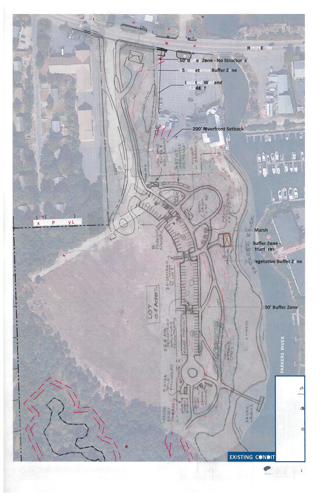
1 Preferred Riverwalk Alternative Components August 17, 2017: 1. Entrance and Future Pump Station Location: Entrance location to line up with main parking entrance to Captain Parkers and allows future Pump Station to be on the east side to minimize impacts to new access road. Curve provided in the entrance road to reduce speeds and locate leaching field on unbuildable lot to the west of the entrance. This is the location of the previously designed subsurface disposal system for the Marina project and can more readily accommodate a mounded system with required separation from the isolated wetland. Locating a septic system on a separate lot is allowed by current Title 5 Regulations, but the Town regulations are a little ambiguous and may require a formal variance request from the BOH (approval likely as there is common ownership). 2. Parking: Design of parking should ensure a vista view from the parking areas (those south of upweller access) so people can enjoy the area from their car in cooler weather or for a lunch break. This may require the parking area to be slightly elevated to view over landscaping, and choice of landscaping in the southern parking areas should be low growing to take this into consideration. The curved parking area mimics the river, allows for parking to extend to the kayak launch for easy access and turn around, provides 81 spaces (4 handicap), allows for easy policing of the Riverwalk Park from police cruisers, and maximizes remaining land for Lot 2. Also included are elevated walkways within the parking areas to reduce speeds and provide pedestrian access to future activities on Lot 2 from the parking area. 3. Security and Safety Measures: The parking design maximizes policing of the area by allowing police vehicles to patrol the length of the park. The addition of decorative lighting in the parking area provides additional security measures. May wish to consider adding security cameras. Signage should be provided noting that the Park is closed dust to dawn and include park rules. Consider not allowing dogs at the park and on the boardwalk. Consider including a gate, even though it would not be locked daily. 4. Restrooms: Provide traditional restrooms by the parking area which can include general welcome center type information. Provide a portable toilet enclosure near the kayak launch (similar to Dennis Pond). Estimate number of fixtures required. 5. Upweller: Provide maintenance vehicle access, but keep pathways away from Upweller due to noise. 6. Seating Options: Provide for variety of seating options, including seating with/without shade structures and less formal seating, such as boulders. Locate to prevent impacts to views and minimize maintenance. 7. Litter: Install solar powered trash compactors throughout park that allow access with the trash truck. 8. Landscaping: Reduce the number of trees to maintain vistas, increase visibility for security and reduce maintenance costs. Keep one large grassed area for events, but reduce mowing and watering by having more maintenance free native vegetation. Use vegetation buffers to restrict access to the salt marsh. Foster butterfly and pollination. Include watering spigots throughout property. 9. Kayaks: Include space with stone pad area for private vendor trailer for rentals, leased storage corral with racks, and safety/educational kiosk on sharing the river. 10. Artist Shanties: Identify locations for potential future artist shanties or tents. 11. Food Trucks: Food trucks for special events only, can designate certain parking areas for food trucks during events. No special location is proposed. 12. Public Art: Provide opportunities throughout the park. 13. Educational Opportunities and Interpretive Signage: Provide opportunities throughout the park, especially at the upwell, and kayak launch and along the River. 14. Interactive/Natural Playscapes: Include play area close to the open green space with shade trees. 15. Events/Activities: Provide open lawn space with Pavilion/picnic tables for wide variety of events and activities.
2 RIVERWALK PARK AND BOARDWALK DRAFT MATERIALS LIST August 17, 2017 Element Materials Questions/Comments RIVERWALK PARK: Entrance Roadway Bituminous pavement with drainage system Pervious Pavement Pedestrian Crossings Parking lot Pathways Curbing/curb stops Restrooms Trash Cans Pedestrian light at Route 28 for safe crossing Elevated walkways throughout the parking lot to access Lot 2 and slow traffic. Permeable Pavement Porous Pavers Bituminous Pavement with drainage system Gravel with crushed stone or shells Crushed Schist Dense Graded Crushed Stone Permeable Pavement Porous Concrete Tiger Sand Moby Mat (some accessible areas) Concrete Curb Stops (no curbing) Granite Curbing Concrete Curbing Traditional Restroom/info center designed for floodplain Portable toilet enclosure with roof near Kayak launch Bigbelly Solar Trash Compactor Recycling Containers Will pervious pavement (PP) stand up to a potential commercial development on Lot 2? What about the maintenance costs? What do we do for Town Roads with PP? If traditional pavement will need a drainage system to meet WPA for treatment, recharge, peak attenuation, etc. Do we want to include a pedestrian signal across Route 28? Security cameras? Do we want a variety of pathway materials? More formal design adjacent to Pavilion and grassed area and more natural further out? Do all these meet handicap accessibility requirements? Do we want curbing around the more formal Pavilion/lawn area and curb stops as we move further south? Do we want to consider compost toilets or exclude due to the maintenance issues? Locate trash cans throughout the park where access by the trash truck is available. Page 1 of 3

3 RIVERWALK PARK AND BOARDWALK DRAFT MATERIALS LIST August 17, 2017 Element Materials Questions/Comments Lighting Decorative Lighting nautical theme, LED, max. 20 high poles. Parking Area only? Ped lights along pathway? Gate at Entrance to Park Decorative style Do we want to include a gate to block off the park even if not locked nightly? Landscaping Include a variety of native species to reduce maintenance, to restore resource buffer areas, and foster butterfly and pollination areas. If including water spigots for plant watering, do we want drinking fountains? Do we want to consider irrigation? Retain one large grass area for events, but reduce other areas requiring mowing. Retain vistas from southern parking areas with low plantings. Reduce number of trees to maintain vistas, increase visibility for security and reduce maintenance costs. Include water spigots around the park for watering. Pavilion at Lawn Area Pre-fab wooden Pavilion with concrete slab What size would work best? Do we want picnic tables in pavilion? Seating Options Benches (with and without shade structure) Casual seating such as boulders Include a variety of seating throughout the park. Interactive/natural Natural Materials Approximate area of the playscape? playscapes Kayaks Vendor Trailer Leased Storage Space Interpretive Signage & Kiosks Stone Pad Area for private vendor Corral Area and Low Racks for leasing No rental locker at this time Signage at the entrance to identify park rules/hours General tourist information board at restrooms Kayak safety education Interpretive signage at the Upweller, pollinating/butterfly areas and along the river What ground material is good under the kayak rack area? Prefer vendor trailer over rental locker to provide education? Number of signs anticipated throughout the park? Let consultant determine materials and sizes for estimating purposes. Page 2 of 3
4 RIVERWALK PARK AND BOARDWALK DRAFT MATERIALS LIST August 17, 2017 Element Materials Questions/Comments Educational Elements? What should this include? Should it just be interpretive signage/kiosks or were we looking for something more substantial initially? Artist Shanties/Tents None initially budgeted Provide area but do not install shanties initially? Start with tents to gauge popularity? Public Art None initially budgeted Do we want to budget an allowance for public art or address later? Food Trucks Utilize portion of parking lot no special area Food Trucks for special events only using a closed off section of the parking lot? BOARDWALK AND WOOD TRAILS: Boardwalk Deck Railings Pathways through Woods Interpretive Signage Southern Yellow Pine IPE (Brazilian Hardwood) Composite Grating (aluminum or composite at bump outs) Wood Post with SS cable Stainless Steel Post and Top Rail with SS cable Aluminum Post and Top Rail with SS cable Crushed Schist Dense Graded Crushed Stone Tiger Sand Moby Mat (some accessible areas) Low profile boardwalk Signage at entrance to boardwalk identify use rules. Signage along the boardwalk including wildlife, plants and marsh ecosystems. What do we have at Bass Hole Boardwalk? Material should allow for donation naming. Grating at bump-outs to ensure sunlight penetration. Prefer aluminum or composite grating? SS posts/rail would be more expensive. Type of railing will impact visuals of the boardwalk. Low profile boardwalk may address sea level rise better but is more expensive. Natural style pathway is consistent with other conservation areas in Town. Number of signs? Can let consultant determine materials and sizes for estimating purposes. Trash Cans Bigbelly Solar Trash Compactor Locate a trash compactor at the entrance to the boardwalk at Seagull Beach Page 3 of 3


5
6


7


8
Riverwalk Park and Boardwalk Feasibility/Concept Design Study Project Number: 17-2-CD Public Meeting - May 30, 2017
 Town of Yarmouth Riverwalk Park and Boardwalk Feasibility/Concept Design Study Project Number: 17-2-CD Public Meeting - May 30, 2017 Introductions Drive-In Site Utilization Committee (DISUC): Jim Saben,
CITY OF SANTA ANA Public Works Agency. PARKWAYS..What are they, and why are they important?
 PARKWAYS..What are they, and why are they important? A parkway generally refers to the narrow piece of land between the street and sidewalk. They are also sometimes called tree lawns, parking strips or
TURN TO THE RIVER CITY PLAZA LANDSCAPE DESIGN CONCEPT May 25, 2016
 Turn to the River is a multi-year project of Art Spaces - Wabash Valley Outdoor Sculpture Collection, Inc. to connect downtown Terre Haute with the Wabash River through public art and design. The four-square
MASTER PLAN IMPLEMENTATION COSTS. Appendix A
 Appendix A MASTER PLAN IMPLEMENTATION COSTS Town of Bradford West Gwillimbury HENDERSON COMMUNITY PARK MASTER PLAN IMPLEMENTATION COSTS Draft Order of Magnitude Costing Revised 5/27/2014 ITEM DESCRIPTION
Broadway Avenue Streetscape Project City of Albert Lea. Streetscape Design Committee Meeting October 29, 2012
 Broadway Avenue Streetscape Project City of Albert Lea Streetscape Design Committee Meeting October 29, 2012 1 Presentation Outline Street Widths, Sidewalk Widths and Bump-Out Configuration Decorative
BEMIDJI CITY COUNCIL Work Session Agenda Monday July 9, 2012
 BEMIDJI CITY COUNCIL Work Session Agenda Monday July 9, 2012 City Hall Conference Room 5:30 p.m. 1. CALL TO ORDER / ROLL CALL 2. REVIEW PARK PLANS FOR PAUL BUNYAN PARK, LIBRARY PARK AND SOUTH SHORE BAUER
Rotary Park / Railroad Lake
 Rotary Park / Railroad Lake Park Location: 600 NW Vesper St. Park Land Established: 1975 Park Size: 12 acres Developed Acres: 12 acres Undeveloped Acres: 0 acres Park Type: Community Park Amenities: 2
Popp s Ferry Causeway Park Back Bay Environmental Educational Center CASHIO COCHRAN LLC
 Popp s Ferry Causeway Park Back Bay Environmental Educational Center CASHIO COCHRAN LLC A LIMITED LIABILITY COMPANY Popp s Ferry Causeway Park Master Plan Prepared for: City of Biloxi Department of Parks
OPPORTUNITIES AND CONSTRAINTS - OXBOW PARK ENTRANCE AND PUT-IN
 OPPORTUNITIES AT OXBOW EXISTING WETLANDS Site is undeveloped and we can design a park that works well from the start. SAND BEACH Potential to eliminate invasive species. DEBRIS (CONCRETE, OLD CARS) VEGETATION
Wilbur Young Park. Park Land Established: Developed Acres: 15 acres Undeveloped Acres: 25 acres
 Wilbur Young Park Park Location: 1100 SE Adams Dairy Parkway Park Land Established: 1987 Park Size: 40 acres Developed Acres: 15 acres Undeveloped Acres: 25 acres Park Type: Community Park Amenities: Shelter
SALEM FOREST RIVER PARK PRELIMINARY POOL AREA ASSESSMENT & MASTER PLAN STUDY. For the City of Salem
 SALEM PRELIMINARY POOL AREA ASSESSMENT & MASTER PLAN STUDY For the City of Salem 6-13-17 This process undertaken by Weston & Sampson is to outline preliminary ideas only of what possibilities exist for
Landscape and Streetscape Design 2.5
 Landscape and Streetscape Design 2.5 2.5.1 Goals 2.5.2 Planting 2.5.3 Sidewalks and Pavement 2.5.4 Furnishings 2.5.5 Walls 2.5.6 Lighting 2.5.7 Stormwater 2.5.8 Street Cross Sections 2.5 LANDSCAPE AND
VEHICULAR AND PEDESTRIAN CIRCULATION
 This perspective sketch communicates the intended character and quality of a proposed streetscape design. Locate benches near a major intersection where people tend to gather. Seating and lighting provide
COMMUNICATION URBAN DESIGN REVIEW BOARD CITY OF DES MOINES, IOWA MAY 16, 2017 MEETING
 COMMUNICATION URBAN DESIGN REVIEW BOARD CITY OF DES MOINES, IOWA MAY 16, 2017 MEETING Subject: Recommendation Prepared by: PRELIMINARY DESIGN REVIEW OF LOCUST STREET BRIDGE CONSTRUCTION & COURT AVENUE,
Providence Waterfront Park
 I-195 Redevelopment Parcels Providence Waterfront Park June 30, 2014 I-195 30% Design Review 1 November 19, 2012 endorses open space design. 2 Design Chronology October 2013 10% Design Submitted for both
Kittson Parkway / Watershed Park Parking Lot
 Kittson Parkway / Watershed Park Parking Lot Date Constructed: Summer 2005 Site Location / Description: Kittson Parkway, North Delta, British Columbia. Permeable parking lot adjacent to Watershed Park;
Preliminary Sketch Plan for Fort Hunter Park
 Preliminary Sketch Plan for Fort Hunter Park Public Presentation November 19, 2009 Dauphin County Parks and Recreation 100 Fort Hunter Road Harrisburg, PA 17110 (717) 599-5188 www.dauphinc.org THOMAS COMITTA
Dowdy Park. Concept Plans TOWN OF NAGS HEAD NORTH CAROLINA. Developed by: Albemarle & Associates, Ltd VHB/ Vanasse Hangen Brustlin, Inc.
 TOWN OF NAGS HEAD NORTH CAROLINA Concept Plans Developed by: Albemarle & Associates, Ltd VHB/ Vanasse Hangen Brustlin, Inc. Site Looking Southeast Dowdy Park Existing Conditions Nags Head Woods Sound Future
Pipeline Trail Master Plan Preliminary Concept Design. O Connor Mokrycke Consultants May 14, 2015 meeting
 Pipeline Trail Master Plan Preliminary Concept Design O Connor Mokrycke Consultants May 14, 2015 meeting 1 Purpose of the Meeting: - Share information regarding traffic studies - Present ideas arising
Project Location. Jay and Patty Baker Park and Gordon River Greenway Connector Bridge. Naples Beach Golf Club. Gordon River. East. Naples.
 Gordon River Project Location Naples Beach Golf Club East Naples Naples Naples Bay Evergreen Golf and Country Club and Gordon River Greenway Connector Bridge Gordon River Greenway CONNECTOR BRIDGE AND
ANCHORAGE PARK REPORT CARD Assessing A Park s Appearance, Function, & Condition
 ANCHORAGE PARK REPORT CARD Assessing A Park s Appearance, Function, & Condition Park Name: Is Your Park an A or an F? Your Name: Contact Information Optional: Date: General Instructions: Phone: Email:
Waterlily Playscape Committee Waterlily Playscape, Waterlily Park, Ocean Shores Draft Concept Plan. G Issue D 14/07/16
 Waterlily Playscape Committee Waterlily Playscape, Waterlily Park, Ocean Shores Draft Concept Plan Issue D 14/07/16 New two level wharf for fishing and interacting with waters edge (exact location to be
3.13. Development Guidelines
 3.3 Landscaping Elements Landscaping should be used to frame and soften structures, define site functions, enhance the quality of the environment, and screen undesirable views. Safety, environmental impacts,
The open space system should provide connective elements, relate to natural resources, and enhance the suburban character of the landscape..
 The open space system should provide connective elements, relate to natural resources, and enhance the suburban character of the landscape.. Mixed-use and infill development should maintain or enhance
Port of Camas-Washougal Waterfront Trail Master Plan
 Port of Camas-Washougal Waterfront Trail Master Plan The Port s facilities are the products of its mission: To make strategic investments that enhance the community s quality of life by bringing jobs,
Project purpose. advise. The purpose of the Beaumaris Lake Open Space Rehabilitation project is to: + Develop a Functional Program Concept
 Project purpose owns Road Beaumaris Road The purpose of the Beaumaris Lake Open Space Rehabilitation project is to: + Develop a Functional Program Concept + Guide Rehabilitation of Landscape and Community
Parker Pine Curve Master Plan January 28th, 2009, Public Workshop Comments
 Group 1 Big Ideas Pedestrian friendly within and to development - bridge over Main Street from downtown. Campus feel. Parking garage like Castle Rocks - Taj garage may be tucked in hillside. Large (big
Appendix C Park Design Guidelines
 Appendix C Park Design Guidelines The following guidelines apply to the design of parks, open space areas and trails in Talent. These guidelines are based on the need for safe, easily maintained spaces,
& SUSTAINABILITY PLAN
 Chapter 6: IMPLEMENTATION, MANAGEMENT, & SUSTAINABILITY PLAN Overview The Oxbow Park and Zollman Zoo Master Plan presents a long-term vision for the park. While phasing of improvements is suggested, Olmsted
PHASE 3-4 PARKS SOUTH PARK AND CHANNEL PARK
 PHASE 3-4 PARKS SOUTH PARK AND CHANNEL PARK Sheet List L1.0 L2.0 L3.0 L4.0 L5.0 L6.0 L7.0 L8.0 L9.0 L10.0 L11.0 L12.0 L13.0 L14.0 L15.0 L16.0 L17.0 L18.0 L19.0 L20.0 L21.0 L22.0 Cover Open Space Context
West Dennis Center: Bass River to Old Main Street. West Dennis Business District: Old Main Street to Dennis Commons
 West Dennis Center: Bass River to Old Main Street West Dennis Business District: Old Main Street to Dennis Commons Dennisport Center: Dennis Commons to Division Street Main Street Project Goals Project
City of Redlands Architectural Guidelines for Non-Residential Development
 14. Building articulation shall be included in the design of building, in order to create a formal entry statement. Avoid this Do this Page 11 15. Give special attention to creating pedestrian scale and
Long Branch-Wayne Local Park Renovation Project
 Montgomery Parks Long Branch-Wayne Local Park Renovation Project Community Meeting #2 September 20, 2016 Oak View Elementary School 7:00-9:00 PM Welcome / Team Introductions M-NCPPC (Montgomery Parks)
Twain Harte Meadows Park Design Workshop #2
 Twain Harte Meadows Park Design Workshop #2 Description of Conceptual Design Schemes Important Notes Design Schemes are Conceptual The purpose of these design schemes is to take a step closer to the general,
4.0 Concept Plan Implementation
 4.0 Concept Plan Implementation The following section defines the recommended strategy for the implementation of the Terwillegar Park Concept Plan including park management guidelines, capital costs, development
Georgeson Botanical Garden Master Plan
 Georgeson Botanical Garden Master Plan Alaska Chapter 2018-03-12 This Master Plan was developed by volunteers representing the Alaska Chapter of the American Society of Landscape Architects. Eliza Bober
Emerson Park Master Plan Update. Public Meeting III August 27, 2014
 Emerson Park Master Plan Update Public Meeting III August 27, 2014 Meeting Agenda: Project Update Presentation of Master Plan Components Discussion and Feedback The Path Forward: Building on the Concept
Main Street Conversion Site
 Main Street Conversion Site Borough of Brooklyn, New York Preliminary Presentation Park Expansion Design & Development Committee 13 September 2012 Michael Van Valkenburgh Associates, Inc. Landscape Architects,
Blue Springs Park. Park Land Established: Developed Acres: 12 acres Undeveloped Acres: 2 acres
 Blue Springs Park Park Location: 2204 SW South Ave. Park Land Established: 1975 Park Size: 14 acres Developed Acres: 12 acres Undeveloped Acres: 2 acres Park Type: Neighborhood Park Amenities: Softball
Route 347. New York State Department of Transportation Region 10, Long Island. THE GREENING of ROUTE 347
 The GREENING of Route 347 The Greening of Route 347 The Greening of Route 347: History 3 The Greening of Route 347 4 The Greening of Route 347 5 The Greening of Route 347 Smith Haven Mall 6 The Greening
BUSINESS DISTRICT DESIGN GUIDELINES
 Des Plaines, Illinois Prepared for the City of Des Plaines by: The Lakota Group Laurie Marston, AICP March 2005 Section 5: Streetscape Elements Business District Design Guidelines STREETSCAPE ELEMENTS
City of Langford Green Development Checklist
 City of Langford Green Development Checklist The following Green Development Checklist creates a sustainability standard for all comprehensive development within the City of Langford. The commitments made
FORT MONROE WATERFRONT PARK. February 09, 2016
 FORT MONROE WATERFRONT PARK February 09, 2016 THEMES: Series of Experiences Connectivity Cohesiveness Multi-functional Spaces Resiliency THEME: SERIES OF EXPERIENCES History Water / Beaches Open Space
The following concept plans and illustrations are the result of this 10 month study of the alley connections from CSU to the River District.
 W E L C O M E T O T H E F O R T C O L L I N S D O W N T O W N A L L E Y S A N D I N T E G R AT E D W A L K W AY S M A S T E R P L A N O P E N H O U S E The following concept plans and illustrations are
APPENDIX G: TOWN ORDINANCE REVIEW
 APPENDIX G: TOWN ORDINANCE REVIEW TYLin (225740) Woodard & Curran SWMP January 2013 Stormwater LID strategies, ranked for Zoning Bylaw and Site Plan Review Standards Dimensional Requirements Permit the
Chapter 4: Jordan Road Character District
 4: Jordan Road Character District 4.1 Introduction The Jordan Road character district encompasses much of the former Jordan orchard and farmstead, which was a significant part of Sedona s history. The
APPENDIX I: GREENWAY DESIGN STANDARDS
 APPENDIX I: GREENWAY DESIGN STANDARDS The goal of this report is to develop a palette of standard design elements that will help establish a distinct identify for the Bronx River Greenway. The greenway
100 Dix Drive Conceptual Master Plan. Wyatt Thompson, PLA, ASLA, Assistant Director Lindsay Stucki, Intern Park Planner
 100 Dix Drive Conceptual Master Plan Wyatt Thompson, PLA, ASLA, Assistant Director Lindsay Stucki, Intern Park Planner Final Draft Prepared August 2018 Introduction On September 20, 2016, the City of Manhattan
GYPSUM PARKWAY CORRIDOR ENHANCEMENT Gypsum, Colorado. Schematic Design January 2015
 GYPSUM PARKWAY CORRIDOR ENHANCEMENT Gypsum, Colorado Schematic Design January 2015 1 2 3 4 5 6 7 8 9 DESIGN WORKSHOP Landscape Architecture Land Planning Urban Design Tourism Planning Asheville Aspen Austin
Riverwood CDD. Severn Trent Services Field Management Report Site Inspection
 Riverwood CDD Severn Trent Services Field Management Report Site Inspection 03.08.2017 1. Lake Management: Water levels continue to recede. Overall clarity is good. No algae issues. Exotic and nuisance
BUSINESS OF THE PLANNING COMMISSION OF THE CITY OF HALF MOON BAY AGENDA REPORT
 For meeting of: BUSINESS OF THE PLANNING COMMISSION OF THE CITY OF HALF MOON BAY AGENDA REPORT TO: FROM: Honorable Chair and Planning Commissioners Jill Ekas, Community Development Director Brittney Cozzolino,
Minneapolis Sculpture Garden Reconstruction and Cowles Conservatory Renovation. 6:00 p.m.
 Minneapolis Sculpture Garden Reconstruction and Community Advisory Committee (CAC) Meeting #5 April 14, 2014 6:00 p.m. Agenda Project Overview Project Goals, Budget, Schedule Refined Schematic Design COWLES
ATTACHMENT A. SILVERDALE DESIGN STANDARDS Amendments to the Waaga Way Town Center Chapter
 ATTACHMENT A SILVERDALE DESIGN STANDARDS Amendments to the Waaga Way Town Center Chapter Chapter 10. Waaga Way Town Center 10.1 Physical Identity Elements & Opportunities The Waaga Way Town Center includes
Chapter 14 Streetscape Improvements
 This chapter presents streetscape design concepts for key streets and gateways in the Downtown Specific Plan area. This chapter is organized as follows: 14 Streetscape Improvements 14.1 Streetscape Treatments
Fair Oaks Ranch Homeowners Association Parks and Trails Master Plan & 2019 Budget Planning
 Fair Oaks Ranch Homeowners Association Parks and Trails Master Plan & 2019 Budget Planning Sticky Dot Voting Priorities Community Survey Results Board Title Votes Parks, Open Spaces, and Trails 328 Emergency
Section 4: Goals, Objectives, and Strategies
 99 Section 4: Goals, Objectives, and Strategies Goal 1 Resource Protection, Maintenance, Preservation, and Enhancement Protect, preserve, maintain, and enhance the natural, recreational, archaeological,
Woods Chapel Park. Park Amenities: Playground, basketball court, single table shelter, small pond and multi-use trail.
 Woods Chapel Park Park Location: 3925 NW Dogwood Park Land Established: 1979 Park Size: 10 acres Developed Acres: 6 acres Undeveloped Acres: 4 acres Park Type: Neighborhood Park Amenities: Playground,
FORT MISSOULA REGIONAL PARK
 FORT MISSOULA REGIONAL PARK Master Plan Refinement/ Design Development www.missoulaparks.org DHM Design/WGM Group December 3, 2008 Master Plan Report Fort Missoula Regional Park Guiding Principals i 6/14/01
ACADEMY AREA CONCEPT PLAN
 ACADEMY AREA Strip ling C hape l Roa d CONCEPT PLAN 7 S2 U Stripling 52 ROADWAYS AND PARKING: ADVENTURE PLAYGROUND AND SPRAYGROUND: Current roadways follow existing drives. It is recommended that the Folds
REPORT TO COUNCIL City of Sacramento
 REPORT TO COUNCIL City of Sacramento 915 I Street, Sacramento, CA 95814-2604' www.cityofsacramento.org CONSENT August 25, 2009 Honorable Mayor and Members of the City Council Title: Contract: Valley Hi
As a public park, it is important to plan your community garden to ensure everyone can gain
 CHAPTER 3: ACCESSIBLE AND INCLUSIVE GARDENS Opportunity for All As a public park, it is important to plan your community garden to ensure everyone can gain access and participate in similar activities.
Report or technical documentations of the target areas in Siauliai
 WP 4 Energy Supply Report or technical documentations of the target areas in Siauliai 2011.10.27 Summary of the draft version of technical documentation for two target areas Lieporiai park 1.1. Works basis
Grand River Ravines Georgetown Township
 Grand River Ravines Georgetown Township Project Description: The Grand River Ravines County Park property is composed of the 68-acre former Fillmore at the Bend Open Space purchased in 1999 and two more
Welcome to. River Dreams on the Rappahannock. 290 Mosquito Beach Lane White Stone, Virginia
 Welcome to River Dreams on the Rappahannock 290 Mosquito Beach Lane White Stone, Virginia Exceptional Waterfront Estate along the Shores of the Rappahannock River with Splendid Water Views & Stunning Sunsets.
CITY AND COUNTY OF DENVER DEPARTMENT OF PUBLIC WORKS CONTRACT NO CONFLUENCE BIKE/PED RAMPS-SOUTH PLATTE GREENWAY STATEMENT OF QUANTITIES
 01050-1 Construction Surveying 1 LS 01500-1 Temporary Fences & Barricades 1,500 LF 02600-1 Shoring, Cofferdam, Temp. Sheeting, & Dewatering 1 LS 01565-1 Storm Drainage & Erosion Sediment Control 1 LS 01565-2
3.1 community vision. 3.3 required plan elements
 Chapter 3 Community Form 3.1 community vision 3.2 Parks & landscaping concepts 3.3 required plan elements D R A F T 20 Community Form Chapter 3 3.0 Community form 3.1 community vision The Specific Plan
Burrus Old Mill Park
 Burrus Old Mill Park Park Location: 112 NW Woods Chapel Rd. Park Land Established: 1969 Park Size: 14 acres Developed Acres: 14 acres Undeveloped Acres: 0 acres Park Type: Neighborhood Park Amenities:
Canal Winchester Parks Master Plan. Public Meeting 2 Thursday, February 2 6:30pm
 Canal Winchester Parks Master Plan Public Meeting 2 Thursday, February 2 6:30pm Meeting Agenda 1. Project overview 2. Project schedule 3. Public input results Survey Public Meeting #1 Stakeholder Interviews
Appendices: Glossary. General Terms. Specific Terms. Low Impact Development Approaches Handbook
 67 67 General Terms Specific Terms 66 Low Impact Development Approaches Handbook The vocabulary of low impact development is evolving, and many terms are used interchangeably and to describe the same or
Recreation Facility Evaluation - Conclusions
 2015 Parks Report Upon initial assessment of the Village parks it was evident that the inventory of the Village s park land, athletic fields, recreational facilities, playgrounds, trails, etc., was substantial,
Clearwater Marina District Boardwalk Design Guidelines and Specifications
 General Information: The Clearwater Marina District Boardwalk Design Guidelines and Specifications, adopted by Ordinance No. 8438-13, should be considered a supplemental document to the City of Clearwater
BRADENTON RIVERWALK EXPANSION MASTER PLAN
 BRADENTON RIVERWALK EXPANSION MASTER PLAN INTRODUCTION & AGENDA Process Update Community Engagement Summary Center for Active Design (CfAD) Recommendations Context and Existing Conditions Master Plan Alternatives
City of Plattsburgh DRI: Downtown Streetscapes & Riverfront Access. Downtown Streetscape and Riverfront Access Design
 City of Plattsburgh DRI: Downtown Streetscapes & Riverfront Access Welcome Thank you for coming this evening. Agenda PART I - Project Context The Downtown Revitalization Program Our DRI Projects Other
FREEWAY/TOURIST DISTRICT
 FREEWAY/TOURIST DISTRICT DESIGN STANDARDS FOR THE CITY OF MOUNTLAKE TERRACE March, 2014 MOUNTLAKE TERRACE FREEWAY/TOURIST DESIGN STANDARDS March, 2014 1 TABLE OF CONTENTS Introduction...1 Design Site Design
ROCKTON DOWNTOWN STREETSCAPE MASTER PLAN. Plan Commission Presentation April 10, 2018 Teska Associates Christopher Burke Engineering
 ROCKTON DOWNTOWN STREETSCAPE MASTER PLAN Plan Commission Presentation April 10, 2018 Teska Associates Christopher Burke Engineering AGENDA 1. Project Scope & Schedule 2. Steering Committee & Community
lakeway mixed use tract open space plan
 LEGEND:. UNDISTURBED NATURAL AREA. ENTRY STATEMENT BUILT INTO HILLSIDE. R.O.W. PLANTING (STREET TREES/LIGHTS). HEB ENTRY DRIVE 5. BIO-FILTRATION IN MEDIAN 6. MAIN ENTRY @ MAIN STREET. EXISTING TREES TO
Urban Design Manual 2.0 DRIVE-THROUGH FACILITIES. Background. Urban Design Challenges
 222221 2.0 DRIVE-THROUGH FACILITIES Background In recent years, drive-through facilities have grown significantly in popularity with drive-through restaurants, in particular, being established on numerous
E. Natural areas include habitats such as wetlands, tidal marshes, waterways, natural drainage-ways, woodlands and grassland meadows.
 Adopted November 1999 I. Purpose A. The purpose of these guidelines is to assist in the design and layout of open space, as provided on developed lots within the District. The intent of these guidelines
Coyote Hills Restoration and Public Access Project Coyote Hills Regional Park C o n c e p t P l a n a n d S i t e P r o g r a m
 Coyote Hills Restoration and Public Access Project Coyote Hills Regional Park C o n c e p t P l a n a n d S i t e P r o g r a m Chris Barton Environmental Programs Manager Aquisition Stewardship Development
Great Neck Library Landscaping Committee Wednesday, January 18, 2017, 7:30pm Main Library
 Great Neck Library Landscaping Committee Wednesday, January 18, 2017, 7:30pm Main Library Board Members: Robert Schaufeld, Chair (RS) Marietta DiCamillo (MD) Josie Pizer (absent) JP Francine Ferrante Krupski
Heritage Park Master Plan. Heritage Park Master Plan
 November 03, 2008 Presentation Objectives 1. Seek Council s endorsement on the design concept 2. Seek pre-budget approval for Phase 1 construction 3. Approve schedule for Phase 1 construction 3 Actions
BRITTINGHAM PARK DOG PARK IMPROVEMENTS PUBLIC INPUT MEETING #2. Sarah Lerner, Landscape Architect - City of Madison Parks Division
 BRITTINGHAM PARK DOG PARK IMPROVEMENTS PUBLIC INPUT MEETING #2 Sarah Lerner, Landscape Architect City of Madison Parks Division TONIGHT S GOALS Existing Conditions Design Considerations Surfacing Options
VIRGINIA KEY CONSENSUS MASTER PLAN
 VIRGINIA KEY CONSENSUS MASTER PLAN JULY 2010 Existing Conditions JULY 2010 STAKEHOLDER INTERVIEW PROCESS, January 18-22, 2007 PUBLIC MEETING #1: SITE INVENTORY AND ANALYSIS, March 29, 2007 PUBLIC MEETING
Community Design Guidelines. Port Wallace DRAFT
 Community Design Guidelines Port Wallace DRAFT Energy 1 2 3 Nature Movement Connections Built Form DRAFT Layout Energy 1 Nature Community Design Guidelines GREAT COMMUNITIES PROTECT, CELEBRATE, AND CONSERVE
CENTRAL PARK LANDSCAPE DESIGN GUIDELINES
 CENTRAL PARK LANDSCAPE DESIGN GUIDELINES 1 of 9 2008 revised draft SUMMARY STATEMENT The City of Bel Aire is undertaking an ambitious transformation, developing a new city centre, with mixed use and a
russell+mills studios
 S C H E M A T I C D E S I G N B O O K L E T O C T O B E R 2 2, 2 0 0 8 114 east oak st, fort col TABLE OF CONTENTS...ii SITE CONTEXT...1 BACKGROUND...2 PARK PROGRAM...3 SLOPE ANALYSIS...4 SPATIAL ANALYSIS...5
GROUND LEVEL ENLARGEMENT / STREETSCAPE AT PIER AVENUE STRAND & PIER HOTEL HERMOSA BEACH HARDSCAPE MATERIAL KEY MAP PIER AVENUE
 COMPOSITE LANDSCAPE LOT B ( MAX SPACES) WILSHIRE BLVD, SUITE 0 BEVERLY HILLS, CA 0 TH STREET WILSHIRE BLVD, SUITE 0 BEVERLY HILLS, CA 0 BRYANT STREET, SUITE 00 SAN FRANCISCO, CA 0 S. FIGUEROA ST. TH FLOOR
alum creek park public workshop January 16, 2014
 alum creek park public workshop January 16, 2014 brief History Schneider Park Early 2000 s - Clean Ohio Fund - Acquisition & Invasive Species Removal SWBMP - Capital University agrees to assist with land
VISION PLAN PRESENTATION - SEPTEMBER 28, 2013
 AREAS OF IMPROVEMENT E A POOL HOUSE POOL DECK B B MAIN BUILDING UPPER PLAZAS A D F G C MAJOR BLEACHERS DUGOUTS FIELD MAIN COURTYARD D REGGIE PARK C E SPORT COURT ADA RAMP H F G H TENNIS COURTS KITCHENETTE
Importance of Master Planning Marcy Colclough
 Importance of Master Planning Marcy Colclough Senior Planner Southwest Michigan Planning Commission WHERE and HOW we develop Land affects Water Quality! 43.2 Acres total 20 Homes 35.8 Acres of open space
Chapter 5: Mixed Use Neighborhood Character District
 5: Mixed Use Neighborhood Character District 5.1 Introduction The Mixed Use Neighborhood character district acts as a transition or bridge between the State Route 89A District s commercial area to the
Reconnecting to a Forgotten River St. Cloud MN. Aaron Hanson Design Design Thesis LA 572, Thesis, Spring 2012
 Reconnecting to a Forgotten River St. Cloud MN Aaron Hanson Design Design Thesis LA 572, Thesis, Spring 2012 site context 2.5 Miles Sartell St. Cloud to Fargo 170 Miles (2 hrs 45 mins) Hwy 10 infrastructure
Green Infrastructure Recommendations For Parks and Public Spaces
 Green Infrastructure Recommendations For Parks and Public Spaces Issued by the Jersey Water Works Green Infrastructure Committee And Prepared by Meliora Design This document recommends ways to integrate
1. Parks & Recreation Neighborhood Parks Community Parks Special Use Sites 2. Open Space 3. Trails
 Appendix A: Park Classifications The intent of parks and recreation classifications is to aid in making acquisition and design decisions for park sites, facilities and the organization of recreation space
PARDI MARKET PLAZA MASTER PLAN
 PARDI MARKET PLAZA MASTER PLAN CITY OF DIXON PLANNING COMMISSION MAY 16, 2017 Presented by: 1 CITY STAFF INTRODUCTION Deborah Barr Associate Civil Engineer, Project Manager Joe Leach City Engineer/Public
Hidden Pointe Landscape Master Plan. June, archi terra
 Hidden Pointe Landscape Master Plan June, 2006 t h e archi terra g r o u p 1 Table of Contents Background Purpose and Goals of the Master Plan Master Plan Process Existing Conditions Entrance Hidden Pointe
Daniels Park Master Plan
 Daniels Park Master Plan Prepared for: Douglas County & The City and County of Denver October, 2007 EXHIBIT A Contents Daniels Park Overview 2 Project History & Goals 2-3 Regional Context Map 4 Park Zone
Bullhead City Rotary Park Plan Update
 Bullhead City Rotary Park Plan Update PLANNERS/LANDSCAPE ARCHITECTS: RBF Consulting 16605 N 28 th Avenue Suite 100 Phoenix, Arizona 85053-7550 (602) 467-2200 CIVIL ENGINEER: RBF Consulting 16605 N. 28
Green Infrastructure and Low-Impact Development Technologies
 Green Infrastructure and Low-Impact Development Technologies The guiding principles of these technologies is to manage stormwater at their sources using natural means, and establish conditions so that
Request Modification of Conditions of a Conditional Use Permit approved October 14, Staff Recommendation Approval. Staff Planner Stephen White
 Applicant Property Owner Public Hearing September 13, 2017 City Council Election District Lynnhaven Agenda Item 3 Request Modification of Conditions of a Conditional Use Permit approved October 14, 2003.