URBAN DESIGN GOALS / POLICIES / MEASURES
|
|
|
- Lorena Joseph
- 5 years ago
- Views:
Transcription
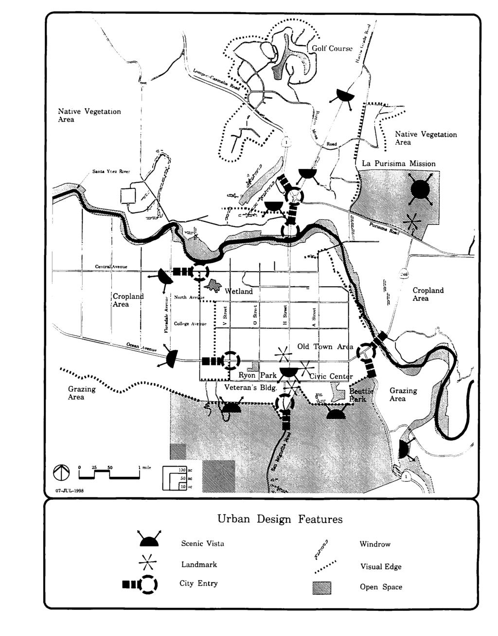
1 URBAN DESIGN GOALS / POLICIES / MEASURES GOALS / POLICIES Authority Consideration of urban design issues in the general plan is provided under the Land Use Element requirements which direct attention to open space uses such as agriculture, natural resources, and the enjoyment of scenic beauty (GC Section 65302(a)). Urban design considerations may also include areas of outstanding beauty, historic, and cultural value under the Open Space Element requirements (GC Section 65560). The Government Code (GC) also allows the City to "address any other subjects, which in the judgement of the legislative body relate to the [City's] physical development" (GC Section 65303). Goal 1 Protect and enhance the natural features and landmarks of the Lompoc Valley. Policy 1.1 Policy 1.2 Policy 1.3 Policy 1.4 The City shall define, protect, and link urban features, rural features, and open space areas in the Lompoc Valley including those identified on the Urban Design Features map. The City shall protect ridgelines and hillsides which lie in view corridors, including those ridgelines identified on the Scenic Ridgelines and Roads map. The City shall protect and enhance the views along the scenic roads noted on the Scenic Ridgelines and Roads map. The City shall create a visual edge to maintain awareness of the community's setting in the Lompoc Valley by establishing and maintaining open space buffers along the western and eastern portions of the Urban Limit Line. URBAN DESIGN - 1
2 Goal 2 Policy 2.1 Policy 2.2 Protect and enhance the "small town" character of the Old Town. The City shall support the historical character, scale, and architecture of the Old Town area. The City shall ensure that all development in the Old Town area is designed in a manner that maintains, encourages, and enhances pedestrian activity between various uses and activities. This includes the design of buildings, street corridors, plazas, and pedestrian spaces. Policy 2.3 The City shall provide for sufficient and conveniently-located public parking to allow the Old Town area to function as a pedestrian-oriented business district without on-site parking. Policy 2.4 The City shall ensure that parking lots in the Old Town area are located and designed to avoid breaking the continuity of building facades. Policy 2.5 The City shall encourage existing commercial facilities to improve their appearance and condition, and ensure that all new development contributes toward an overall positive and cohesive visual identity. Goal 3 Protect and enhance the positive identity of Lompoc's residential neighborhoods. Policy 3.1 The City shall protect and enhance the positive identity of residential neighborhoods. Policy 3.2 The City shall require infill development to respect the scale and character of existing neighborhoods. Policy 3.3 The City shall encourage the protection of structures and neighborhoods which possess locallysignificant architectural styles or historic values. Infill development in such areas shall be architecturally compatible with surrounding structures. Policy 3.4 The City shall encourage and support the efforts of homeowner and neighborhood associations to improve the visual appearance of residential neighborhoods. URBAN DESIGN - 2
3 Goal 4 Protect and enhance the visual qualities of Lompoc's urban streetscapes and public places. Policy 4.1 The City shall support efforts to improve the appearance of expressways and arterials. Policy 4.2 Policy 4.3 Policy 4.4 The City shall promote cleanliness and regular maintenance of all neighborhoods and public places. The City shall encourage signage which enhances the visual qualities of the urban streetscape. The City shall continue to encourage provision of art in public places. Policy 4.5 The City shall encourage the owners and/or operators of land uses and activities which are unsightly to clean up the affected area or to use landscaping and other design measures to soften or screen the area. Policy 4.6 Policy 4.7 Goal 5 Policy 5.1 Policy 5.2 The City shall encourage the development of the urban forest along streetscapes and in public places. The City shall encourage the provision of open space in all public places. Ensure high-quality design and development. The City shall ensure that all public and private improvements or development projects are consistent with the architectural, landscaping, and site design requirements. The City shall periodically review and update its architectural, landscaping, and site plan review process, as well as any associated guidelines. IMPLEMENTATION MEASURES Measure 1 The Beautification Commission shall establish policies and programs to define and enhance the entryways into the City in cooperation with Caltrans, Santa Barbara County, and the affected property owners. [Policies 1.1, 1.3, and 4.1] Measure 2 The City shall amend the Zoning Ordinance to URBAN DESIGN - 3
4 require new homeowner associations to maintain and preserve natural habitats within their respective developments.[policy 1.1] Measure 3 The City shall amend the Zoning Ordinance to require buffer areas between new developments and bordering land planned by the City for agriculture. [Policies 1.1, 1.4, and 1.6] Measure 4 The City shall amend the Zoning Ordinance to retain ridgelines identified in the Scenic Ridgelines and Roads map in the "Open Space District".[Policy 1.2] Measure 5 The City shall amend the Zoning Ordinance to establish standards for development in hillside areas. These shall address issues such as design, allowable uses, developable areas, safety concerns, parcel sizes, grading, landscaping, visual resources, open space, drainage, infrastructure requirements, and evacuation plans. [Policies 1.1 and 1.2] Measure 6 Measure 7 The City shall amend the Zoning Ordinance to add an overlay zone for scenic corridors which regulates development activities within a defined buffer along designated scenic roads. The overlay zone may address issues such as removal of mature vegetation, grading activities, allowable uses (e.g. signs, walkways, roadway access). [Policies 1.3 and 4.1] The City shall periodically review and update the architectural, landscape, and site plan review guidelines. Architectural review requirements shall be added for rehabilitations of, or additions to existing buildings, and for projects located along designated scenic roads. [Policies 1.3, 2.1, 2.2, 3.1, 3.2, 5.1, and 5.2] Measure 8 The City shall amend the Zoning Ordinance to: 1) add a design overlay zone in the Old Town area; and 2) establish design guidelines for the architectural appearance, site function, pedestrian enhancement, protection and development of structures within the overlay zone. All development within the overlay zone must conform with the guidelines. [Policies 2.1, 2.2, 2.3, and 2.4] Measure 9 The City shall amend the Zoning Ordinance to URBAN DESIGN - 4
5 establish design guidelines for the Southside Old Town (generally the blocks of South "G" and "H" Streets and blocks of South "I" and "J" Streets) to preserve historic structures, encourage rehabilitation, and ensure that new construction and rehabilitation are compatible with the surrounding historic structures. Measure 10 The City shall explore methods for providing sufficient off-site parking in the Old Town area. [Policies 2.2 and 2.3] Measure 11 The City shall amend the City Code to increase the maintenance standards for commercial and industrial facilities. [Policy 2.5] Measure 12 The City shall amend the Zoning Ordinance to include minimum standards for the percentage of the required open space areas (exclusive of natural habitat) of developments which need to be landscaped in order to minimize storm runoff. [Policies 2.5 and 3.1] Measure 13 Measure 14 The City shall review the street-naming and streetnumbering policy for future developments. [Policy 3.1] The City shall designate the Italian Stone Pines on South H Street as a heritage grove. [Policy 1.1] Measure 15 The City shall explore the establishment of landscape maintenance districts. [Policy 4.1] Measure 16 Measure 17 The City shall establish a citywide street tree median and parkstrip planting program, if funding is available. Landscaped areas shall be located and designed to maintain vehicular and pedestrian safety, to beautify the roadways, and to maintain traffic-flow efficiency. [Policy 4.1] The City shall use landscaping to screen unsightly land uses or activities on City-owned land. [Policies 4.1, 4.2, and 4.5] Measure 18 The City shall review the Sign Ordinance, and update as necessary. [Policy 4.3] Measure 19 The Planning Commission and Beautification Commission shall review existing Engineering Division standards for consistency with the policies of the Urban Design Element. [Policies URBAN DESIGN - 5
6 2.2, 2.3, 3.1, 4.1, and 5.1] Measure 20 The City shall identify boundaries of the Old Town area and include those boundaries on the Zoning Map. Measure 21 Measure 22 Measure 23 The City shall condition approval of individual development proposals to be consistent with Land Use Element Policies 5.11 and [Final EIR Urban Design Mitigation Measures 1a and 1b] The City shall condition approval of individual development proposals to assure that development shall preserve important view corridors, where feasible, by identifying and preserving the attributes of the view corridor that characterize its significance (e.g. framing elements and presence or absence of impinging details) as seen from roadways, pedestrian paths or other public vantage points to avoid view obstruction. Buildings shall be sited so as to minimize view obstruction from sensitive vantage points. This measure shall be accomplished through amendment of the zoning ordinance to include standards for view protection as indicated in this measure. [Final EIR Urban Design Mitigation Measures 2a] The City shall amend the zoning ordinance so that the following glare reduction measures are applied when reviewing new development on a parcel specific basis: Utilize trees or other forms of vegetation to screen and visually soften parking areas. This measure would reduce the amount of glare generated from painted and chrome automobile surfaces and prevent expanses of stationary and moving automobiles; Require use of hooded lights on focused-beam lamps for nighttime illumination in parking areas, shipping and receiving docks and within industrial developments. These lights direct the light beam towards the ground, which if a dark pavement, will not reflect light and cause spillage into neighboring areas; and Require use of materials which reduce or diminish URBAN DESIGN - 6
7 glare for windows in new developments. [Final EIR Urban Design Mitigation Measures 3a] Measure 24 The City shall continue to review development proposals on a project-specific basis with added attention to avoidance to degradation of objects or aesthetic and/or historical significance. New development shall be subject to design review as part of the City's project approval process. [Final EIR Urban Design Mitigation Measures 4a] Measure 25 The City staff shall coordinate planning, design, and maintenance of roadway medians, parkstrips, and open space areas with the parks and Recreation Department through the Development Review Board process. [Notes: The following policies are implemented through the current City Codes and procedures: Policies 3.3, , and 4.7] URBAN DESIGN - 7
8
9
Table L-1 Summary Action Strategy. Action Item Timing Status Responsible Agency
 CHAPTER 4: CIRCULATION ELEMENT ISSUE #1: MAJOR THOROUFARES AND TRANSPORTATION ROUTES A balanced transportation system for Fontana is provided that meets the mobility needs of current and future residents
4. INDUSTRIAL 53 CASTLE ROCK DESIGN
 4. INDUSTRIAL 53 CASTLE ROCK DESIGN CASTLE ROCK DESIGN 54 4. INDUSTRIAL Overview Well-designed and attractive industrial centers are the product of blending economic realities with both functional and
Community Design. Our Use of Land. Introduction
 Community Design Our Use of Land Introduction This element addresses the physical form of the natural environment and the built form of the City. The major features that give San Rafael its visual character
SECTION II SECTION II STATEMENT OF GOALS, OBJECTIVES, PRINCIPLES, ASSUMPTIONS, POLICIES AND STANDARDS
 STATEMENT OF GOALS, OBJECTIVES, PRINCIPLES, ASSUMPTIONS, POLICIES AND STANDARDS 1 2 STATEMENT OF GOALS, OBJECTIVES, PRINCIPLES, ASSUMPTIONS, POLICIES AND STANDARDS INTRODUCTION The New Jersey Municipal
section five BEAUTIFICATION PLAN
 section five BEAUTIFICATION PLAN BEAUTIFICATION PLAN Section Five Beautification Plan The goal of the Beautification Plan is to improve the Route 8-Sunnyland Corridor in terms of aesthetics and to create
The Vision. Photo provided by The Minervini Group. 46 Vision, Objectives & Strategies
 Vision, Objectives & Strategies The is the public framework and guide for future development of the Grand Traverse Commons. The establishes public polices for infrastructure, the preservation of natural
Community Design Plan
 Gardena General Plan 2006 Authority While the is not a required element of a General Plan, it is included because improving the community appearance and image is paramount to the overall quality of life
3.10 LAND USE SETTING PROJECT SITE EXISTING LAND USE DESIGNATIONS AND ZONING. General Plan Land Use Designations.
 This section of the Draft EIR addresses the existing land uses on and adjacent to the project site and discusses the potential impacts of the proposed project on existing land uses. Key issues addressed
GENERAL PLAN CONSISTENCY ANALYSIS
 GENERAL PLAN CONSISTENCY ANALYSIS Prepared by Planning Staff 10/28/2013 APPLICABLE GOALS, POLICIES AND PROGRAMS FROM the LAND USE CHAPTER Goal LU-1 Policy LU-1.1 Policy LU-1.2 Goal LU-2 Protect the character
V. Vision and Guiding Principles
 V. Vision and Guiding Principles The Master Plan for the Powers Ferry Corridor seeks a foundation in the desires of the community. At times, various elements of the community offered opposing viewpoints,
Land Use Element. policy areas are discussed in this Element:
 Land Use Element Land Use is often considered the heart of the General Plan. The statement of future land uses describes how the City believes it should develop in the future where housing, shopping, open
3.1 AESTHETICS Background and Methodology
 3.1 AESTHETICS 3.1.1 Background and Methodology 3.1.1.1 Regulatory Context The California Environmental Quality Act (CEQA) requires that project sponsors evaluate the project s potential to cause aesthetic
5.11 AESTHETICS ENVIRONMENTAL SETTING
 5.11 AESTHETICS ENVIRONMENTAL SETTING The lies on a relatively flat valley floor surrounded by rugged hills and mountains. The topography of the planning area is defined by the Box Springs Mountains and
Land Use element LAND USE POLICY AREAS ESTATE AND RURAL RESIDENTIAL AREAS/RURAL SHELDON AREA OLD TOWN ELK GROVE
 Land Use element Land Use is often considered the heart of the General Plan. The statement of future land uses describes how the City believes it should develop in the future where housing, shopping, open
Planned Development Review Revisions (Project No. PLNPCM )
") Planned Development Review Revisions (Project No. PLNPCM2014-00139) Standard residential development Planned Development Example: Smaller lot sizes than what is allowed to create open space amenity. What
Planned Development Review Revisions (Project No. PLNPCM2014-00139) Standard residential development Planned Development Example: Smaller lot sizes than what is allowed to create open space amenity. What
APPENDIX C. Architectural and Environmental Design Standards. Environmentally sensitive areas should be protected.
 APPENDIX C Architectural and Environmental Design Standards Environmentally Sensitive Areas Goal A. Environmentally sensitive areas should be protected. Development, such as roads, houses, and other structures,
WEST LOOP DESIGN GUIDELINES CHECKLIST
 WEST LOOP DESIGN GUIDELINES CHECKLIST Section 1.0 General Strategies 1.1 DESIGN EXCELLENCE: ENCOURAGE HIGH QUALITY AND INNOVATIVE DESIGN OF NEW BUILDINGS WITHIN THE WEST LOOP WITHOUT BEING PRESCRIPTIVE
CHAPTER 13 DESIGN GUIDELINES
 CHAPTER 13 DESIGN GUIDELINES Section 1300.00 Section 1300.01 Design Guidelines Purpose The purposes of this section are to: A. The purpose of this Section is to establish procedures and standards to serve
Parks, Recreation, and Open Space Land Use Goals
 Parks, Recreation, and Open Space Land Use Goals Issue: The preservation of open space and natural features will enhance the character of the built environment, promote public health and safety, provide
Parks, Trails, and Open space Element
 Parks, Trails, and Open space Element Parks, Trails, and Open Space element Parks, Recreation, and Open Space are important components of the quality of life desired by the residents of Elk Grove. This
Corridor Identity. Section 9. Introduction. Corridor Guiding Principles
 Corridor Identity An attractive and healthy community is a critical element of a quality place, and the design of quality places is a balance between environmental, economic, and social considerations.
Parks, Trails, and Open Space Element
 P arks, Recreation, and Open Space are important components of the quality of life desired by the residents of Elk Grove. This Element of the General Plan addresses the City s goals, policies, and actions
Chapter 4 Urban Design Element
 Chapter 4 Urban Design Element "The general tenor of the responses indicates a strong preference to not allow low-intensity development into natural areas, resource lands or highly visible open space.
COMMUNITY DESIGN. GOAL: Create livable and attractive communities. Intent
 COMMUNITY DESIGN Intent An attractive, well-designed County will attract quality development, instill civic pride, improve the visual character of the community, and create a strong, positive image for
CITY of LOMPOC 2030 General Plan
 2030 General Plan INTRODUCTION AND AUTHORITY The Land Use Element is a mandatory element of the General Plan. Section 65302(a) of the Government Code states that the Land Use Element must designate the
E. RURAL COMMERCIAL/INDUSTRIAL PARK MODEL
 E. RURAL COMMERCIAL/INDUSTRIAL PARK MODEL 1. PURPOSE The purpose of the Rural Commerce/Industrial Park Model is to provide parameters within which a grouping of business buildings with parking, loading
ARTICLE V PLANNED UNIT DEVELOPMENT DISTRICT
 ARTICLE V PLANNED UNIT DEVELOPMENT DISTRICT A. Purpose and Objective The Planned Unit Development (PUD) procedure provides a flexible land use and design regulation through the use of performance criteria
2.0 AREA PLANS. Lakeside Business District. Lakeside Business District Land Use Categories:
 Lakeside Business District Lakeside Business District Land Use Categories: Campus Commercial Campus Commercial means a mixture of uses which includes corporate offices, office parks, hotels, commercial,
PUBLIC SERVICES ELEMENT GOALS / POLICIES / MEASURES
 PUBLIC SERVICES ELEMENT GOALS / POLICIES GOALS / POLICIES / MEASURES Authority The Public Services Element addresses provision of municipal services to City residents. The following paragraphs provide
4.6 LAND USE. b. Regulatory Setting. The Specific Plan area includes the following General Plan land use designations, as shown in Figure 2-3:
 4.6 LAND USE 4.6.1 Environmental Setting a. Existing Land Uses. The Specific Plan area, located in the center of the City in the downtown core area, consists of about 50 square blocks radiating from the
Protecting Scenic Views
 The Genesee-Finger Lakes Region is distinguished by roadway corridors and locations from which outstanding scenic views can be appreciated. Our special views encompass agricultural lands, natural areas,
3.1 Aesthetics, Light, and Glare
 3.1 3.1.1 Introduction This section describes the existing aesthetics, light, and glare setting and potential effects from project implementation on visual resources and the site and its surroundings.
Town Center. Block 5 Existing multifamily residential units are expected to remain.
 Area Guidelines Germantown s districts should be developed as distinct communities with unique features that are supported through the guidelines. The guidelines not only help distinguish these districts
Introduction...UD-1. Plan...UD-3
 URBAN DESIGN ELEMENT TABLE OF CONTENTS Section Page Introduction...UD-1 Purpose of the Urban Design Element...UD-1 Scope and Content of the Urban Design Element...UD-1 Related Plans and Programs...UD-1
EXISTING COMPREHENSIVE PLAN
 EXISTING COMPREHENSIVE PLAN Town Center Land Use Element: V. LAND USE POLICIES Town Center Mercer Island's business district vision as described in "Your Mercer Island Citizen-Designed Downtown" was an
4.1 Aesthetics Setting. a. Visual Character
 Environmental Impact Analysis Aesthetics 4.1 Aesthetics This section analyzes the proposed Specific Plan s impacts related to aesthetics, including the existing visual character of and scenic views in
FLORIN ROAD CORRIDOR Site Plan and Design Review Guidelines Checklist
 FLORIN ROAD CORRIDOR Site Plan and Design Review Guidelines Checklist Applicant s Name: Project Address: Phone: Email: Applicant shall fill out the design guidelines checklist for all guidelines applicable
Asbury Chapel Subdivision Sketch Plan
 Asbury Chapel Subdivision Sketch Plan PART 1: PROJECT SUMMARY Applicant: NVR Inc. Project Size: +/- 76.13 acres Parcel Numbers: 02101112,02116101,02116112, 02116113 Current Zoning: Transitional Residential
hermitage town center
 hermitage town center A Community Vision prepared by Strada for The City of Hermitage and The Mercer County Regional Planning Commission January 2007 table of contents introduction 3 design principles
4.9 Mendocino Avenue Corridor Plan Design Guidelines
 4.9 Mendocino Avenue Corridor Plan Design Guidelines The Mendocino Avenue Corridor Plan addresses the area between College Avenue and Steele Lane. Mendocino Avenue is a busy arterial that runs parallel
COMMERCIAL DESIGN REVIEW APPLICATION
 CITY OF LACEY Community Development Department 420 College Street Lacey, WA 98503 (360) 491-5642 COMMERCIAL DESIGN REVIEW APPLICATION OFFICIAL USE ONLY Case Number: Date Received: By: Related Case Numbers:
Policies and Code Intent Sections Related to Town Center
 Policies and Code Intent Sections Related to Town Center The Town Center Vision is scattered throughout the Comprehensive Plan, development code and the 1994 Town Center Plan. What follows are sections
GENERAL PLAN AND ENVIRONMENTAL IMPACT REPORT
 City of Menifee HEARING DRAFT GENERAL PLAN AND ENVIRONMENTAL IMPACT REPORT City Council November 2013 PURPOSE OF MEETING Overview of GP Process Overview of required and optional GP elements Receive direction
PROTECT AND PROMOTE QUALITY OF LIFE AND LIVABILITY FOR THE CITIZENS OF GAINESVILLE THROUGH QUALITY URBAN DESIGN.
 Goals, & Urban Design Element PROTECT AND PROMOTE QUALITY OF LIFE AND LIVABILITY FOR THE CITIZENS OF GAINESVILLE THROUGH QUALITY URBAN DESIGN. GOAL 1 By 2003, the City shall adopt urban design standards
SAN RAFAEL GENERAL PLAN 2040 INTRODUCTION AND OVERVIEW
 SAN RAFAEL GENERAL PLAN 2040 INTRODUCTION AND OVERVIEW Steering Committee Presentation February 14, 2018 Purpose of General Plan Guide land use and development decisions Coordinate transportation, infrastructure,
McDonald s Restaurant - Purcellville Town of Purcellville Special Use Permit Statement of Justification July 24, 2014
 Introduction / Written Statement McDonald s Restaurant - Purcellville McDonald s Corporation is proposing to redevelop the existing McDonald s eating establishment with a drive-through located at 121 N
Nob Hill Pipeline Improvements Project EIR
 Section 3.1 Aesthetics This section addresses the visual aspects that may affect the views experienced by the public, including the potential to impact the existing character of each area that comprises
EXECUTIVE SUMMARY DRAFT CHAPTER 1 INTRODUCTION EXECUTIVE SUMMARY
 CHAPTER 1 EXECUTIVE SUMMARY INTRODUCTION Through the joint efforts of the City of Tulsa planning staff and the Land Services division of Indian Nations Council of Governments (INCOG), the Berryhill Land
3.1 AESTHETICS AND VISUAL RESOURCES
 3.1 AESTHETICS AND VISUAL RESOURCES This section examines the potential for the proposed Project to create aesthetic and visual impacts as defined by the California Environmental Quality Act (CEQA) as
Infill Residential Design Guidelines
 Infill Residential Design Guidelines Adopted March 23, 2004 Amended September 10, 2013 City of Orange Community Development Department Planning Division Phone: (714) 744-7220 Fax: (714) 744-7222 www.cityoforange.org
4.1 AESTHETICS. A. Regulatory Framework
 4.1 This section includes a description of the existing visual setting of the project site and an analysis of the effects the proposed project would have on aesthetics in the project vicinity. Aesthetics
The open space system should provide connective elements, relate to natural resources, and enhance the suburban character of the landscape..
 The open space system should provide connective elements, relate to natural resources, and enhance the suburban character of the landscape.. Mixed-use and infill development should maintain or enhance
Residential Design Guidelines
 Residential Design Guidelines Single-Family Residential Design Guidelines Introduction These guidelines seek to provide property owners, designers and developers with a clear understanding of the City
July 6 th, Re: The Sugarmont Apartments Planned Development. Dear John,
 July 6 th, 2016 Planning Division Community And Economic Development Salt Lake City Corporation c/o John Anderson 451 South State Street, Room 215 Salt Lake City, Utah 84114 Re: The Sugarmont Apartments
Master Plan Objectives and Policies
 Master Plan Objectives and Policies Introduction This chapter identifies the Park issues and recommended policies established by this Master Plan. The issues were identified through meetings with staff,
LAND USE ELEMENT. Purpose. General Goals & Policies
 LAND USE ELEMENT Purpose This Land Use Element contains the goals and policies necessary to support the City s responsibility for managing land resources and guiding development through implementing regulations,
CHAPTER 10 AESTHETICS
 CHAPTER 10 AESTHETICS CHAPTER 10 AESTHETICS This section identifies and evaluates key visual resources in the project area to determine the degree of visual impact that would be attributable to the project.
The transportation system in a community is an
 7 TRANSPORTATION The transportation system in a community is an important factor contributing to the quality of life of the residents. Without a sound transportation system to bring both goods and patrons
Chapter 11. Industrial Design Guidelines 11.1 INTRODUCTION AND PURPOSE 11.3 SITE PLANNING GUIDELINES 11.2 GENERAL DESIGN OBJECTIVES
 Chapter 11 Industrial Design Guidelines 11.1 INTRODUCTION AND PURPOSE The following industrial/design guidelines seek to assure high quality development in Santa Ana s industrial districts by: The design
LANDSCAPING. Design. Development of the site shall not unreasonably impair the ability of adjoining properties to utilize solar energy.
 Landscape design is an integral component of Site Planning and Building. The current pattern of walkways, driveways and landscape elements such as fences, hedges, and retaining walls in the neighborhood
Clackamas County Comprehensive Plan. Chapter 4: LAND USE
 Chapter 4: LAND USE When the pioneers settled Clackamas County, the land resource appeared infinite. They cleared forest, carved towns from the wilderness, and used waterways as the arterials of commerce.
Planning Districts INTRODUCTION
 INTRODUCTION To facilitate detailed examination of development prospects for all areas of the community, Delano has been divided into 14 planning districts. The location of these planning districts is
Site Design (Table 2) Fact Sheet & Focus Questions:
 Fact Sheet & Focus Questions:") Site Design (Table 2) Fact Sheet & Focus Questions: BACKGROUND WHAT IS SITE DESIGN? Site design refers to the arrangement of buildings and open spaces on adjacent sites to maximize the shared benefits
Site Design (Table 2) Fact Sheet & Focus Questions: BACKGROUND WHAT IS SITE DESIGN? Site design refers to the arrangement of buildings and open spaces on adjacent sites to maximize the shared benefits
COMPLETE GREEN STREET CHECKLIST
 COMPLETE GREEN STREET CHECKLIST This document was developed to dissect the structure of an urban street and explore opportunities to make our streets more complete while also integrating green street strategies.
TREASURE COAST REGIONAL PLANNING COUNCIL M E M O R A N D U M. To: Council Members AGENDA ITEM 5H
 TREASURE COAST REGIONAL PLANNING COUNCIL M E M O R A N D U M To: Council Members AGENDA ITEM 5H From: Date: Subject: Staff October 17, 2008 Council Meeting Local Government Comprehensive Plan Review Draft
Joint Study Session of the Sutter County. March 2, 2009
 Joint Study Session of the Sutter County Board of Supervisors and Planning Commission March 2, 2009 CURRENT APPLICATION General Plan Amendment Specific Plan Specific Plan Appendices Utility Plans Transit/AQ
4.1.3 LAND USE CATEGORIES
 4.1.3 LAND USE CATEGORIES a. City Center District The City Center District incorporates the existing character and mix of uses in downtown Belmont to encourage redevelopment and new development in keeping
I. STAFF POLICY RECOMMENDATIONS. The following RMP policy strategies are proposed by staff in support of a Scenic Resource Protection Program:
 Policy Consideration: Scenic Resource Protection Program Status: For Consideration by the Highlands Council at September 14, 2006 Work session Date: September 12, 2006 I. STAFF POLICY RECOMMENDATIONS The
In surveys, Dallas residents say what they want to change most
 NEIGHBORHOODS ELEMENT In surveys, Dallas residents say what they want to change most in the city is its appearance they want it to look beautiful, with trees and pedestrian-friendly neighborhoods. The
SQUAMISH 2010 AND BEYOND COMMUNITY VISION
 Our plan has been imagined and created to be both pragmatic and visionary. At the core of the strategy is a consideration of the highway s role and its impact on the community. First and foremost in creating
V. Urban Design A. INTRODUCTION B. CITY IMAGE
 V. Urban Design A. INTRODUCTION Urban design refers to the physical form and development of a city from the individual neighborhood to the overall city scape. In the largest sense, urban design encompasses
Venice Pumping Plant Dual Force Main Project Draft EIR
 City of Los Angeles 5.9 LAND USE PLANS 5.9.1 Environmental Setting Venice Pumping Plant Dual Force Main Project Draft EIR The Project lies within the bounds of Los Angeles County and the City of Los Angeles.
G. RECREATION AND OPEN SPACE ELEMENT. The following summarizes the Recreation and Open Space Element:
 G. RECREATION AND OPEN SPACE ELEMENT The purpose of the Element is to provide the framework and direction for a comprehensive system of public and private sites for recreation, including, but not limited
A. Background Summary of Existing Challenges and Potential Possibilities. 1. Summary of Existing Assets and Potential Opportunities
 A. Background 1 A Main Street Master Plan Study was performed and completed in October of 2007. The study was initiated to review current land uses and development patterns along Main Street, from Parrish
Keyport. Vision for Keyport
 Keyport Vision for Keyport Keyport is a rural, historic waterfront village bounded and limited in size by its natural borders of water and the Naval Undersea Warfare Center. The community consists primarily
SECTION TWO: Overall Design Guidelines
 SECTION TWO: Overall Design Guidelines This section provides overall design principles and guidelines for the Gardnerville Mixed-use Overlay. They provide criteria for mixed-use places consisting of residential,
ARTICLE 6: Special and Planned Development Districts
 ARTICLE 6: Special and Planned Development Districts 6-10 Traditional Neighborhood Development (TND) District 6-10.10 Purpose and Intent The Traditional Neighborhood Development (TND) District provides
A. WHAT IS A GENERAL PLAN?
 I. Introduction A. WHAT IS A GENERAL PLAN? A general plan is the planning guideline for the future of a city. It contains goals and policies which regulate urban development, the protection of the natural
MULTIFAMILY RESIDENTIAL DESIGN PRINCIPLES Site Plan and Design Review Principles Checklist
 MULTIFAMILY RESIDENTIAL DESIGN PRINCIPLES Site Plan and Design Review Principles Checklist Applicant s Name: Project Address: Phone: Email: Applicant shall fill out the design guidelines checklist for
WASHINGTON COUNTY OREGON
 WASHINGTON COUNTY OREGON July 9, 2009 Revisions to Chapter 2 of the Bethany Community Plan The North Bethany Subarea Plan Exhibit pages 7 and 8 The sections for the Core and Flexible Streets were amended
CHAPTER FIVE COMMUNITY DESIGN
 CHAPTER FIVE COMMUNITY DESIGN CHAPTER FIVE - COMMUNITY DESIGN Assumptions Frazier Park and Lebec have historically developed according to different patterns of spatial form. While both communities are
Draft Stillwater 2030 Comprehensive Plan- Goals and Policies
 Draft Stillwater 2030 Comprehensive Plan- Goals and Policies Instructions- Review each goal and policy and discuss with group any changes, deletions for additions to the list using your groups pen. Keep
Town of Peru Comprehensive Plan Executive Summary
 Town of Peru Comprehensive Plan Executive Communities that plan grow by choice, not by chance. A plan makes growth thoughtful, understandable, and predictable. A plan shows that a community is managing
Whitemarsh Comprehensive Plan Update: Housing & Land Use. Public Workshop #3: September 20, 2018
 Whitemarsh Comprehensive Plan Update: Housing & Land Use Public Workshop #3: September 20, 2018 Agenda Welcome Process Recap What We ve Heard The Plan Framework Review of Recommended Actions Land Use Housing
CHAPTER 12 IMPLEMENTATION
 CHAPTER 12 IMPLEMENTATION The 2010 Town of Denton Comprehensive Plan is intended to capture a vision of the future of Denton. As such, it provides a basis for a wide variety of public and private actions
The Palisades Interstate Parkway and Henry Hudson Drive designated a New Jersey State Scenic Byway, 2005
 The Palisades Interstate Parkway and Henry Hudson Drive designated a New Jersey State Scenic Byway, 2005 What are scenic byways? How Did Scenic Byways Come About? National Scenic Byways Program Administered
1.0 Circulation Element
 5/9/18 1.0 Circulation Element 1.1 Introduction As growth and development occur in Apache County, enhancements to its circulation system will be necessary. With time, more roads will be paved and air and
Status Update (2006 vs. Now) Citizen s Advisory Committee February Plan for Prosperity
 Citizen s Advisory Committee February Plan for Prosperity") Status Update (2006 vs. Now) Citizen s Advisory Committee February 2018 Plan for Prosperity 2000 2017 2000 2017 Gardnerville Population 6,000 5,760 5746 5,500 5,000 5,067 5,550 5,165 5,394 5,412 5,250
Status Update (2006 vs. Now) Citizen s Advisory Committee February 2018 Plan for Prosperity 2000 2017 2000 2017 Gardnerville Population 6,000 5,760 5746 5,500 5,000 5,067 5,550 5,165 5,394 5,412 5,250
17.11 Establishment of Land Use Districts
 17.11 Establishment of Land Use Districts 17.11.010 Purpose. To promote the health, safety, and general welfare of City residents and those who come to South Salt Lake to work, exchange commerce and recreate.
PLANNING COMMISSION. Agenda Item # 6.
 PLANNING COMMISSION Agenda Item # 6. LAND DEVELOPMENT CODE AMENDMENT Planning Commission: October 5, 2016 Case: LDC-6-1016 Staff Contact: Eryn K. Moller; eryn.moller@wilmingtonnc.gov 910-341-4695 Staff
D. Landscape Design. 1. Coverage Intent: To provide adequate landscaping materials that enhance the appearance of development projects.
 D. Landscape Design The standards and guidelines in this section give design guidance for the landscaping components of industrial and office projects. City regulations require that all landscaping be
Table of Contents. Elm Avenue Improvement Plan City of Waco, Texas. Introduction 1. Existing Context 1 Figure 1 2.
 Table of Contents Introduction 1 Existing Context 1 Figure 1 2 Plan Guidelines 3 Future Urban Form 4 The West-End 4 Main Street 6 The East-End 7 Figure 2 9 Public Improvement Recommendations 7 General
SECTION UNIFIED DEVELOPMENT ORDINANCE SECTION Part 1 Ordinance. ARTICLE 1 Zoning Districts
 SECTION 1-100 UNIFIED DEVELOPMENT ORDINANCE SECTION 1-300 Part 1 Ordinance SECTION 1-100. Introduction. ARTICLE 1 Zoning Districts Crystal Lake strives to maintain a balance of various land uses for a
Environmental Setting, Impacts, and Mitigation Measures
 CHAPTER 3 Environmental Setting, Impacts, and Mitigation Measures Format of the Environmental Analysis The assessment of each environmental resource discussed in this chapter includes the following: Environmental
DRAFT. October Wheaton. Design Guidelines
 October 2011 DRAFT Wheaton Design Guidelines 2 Draft - Design Guidelines - Wheaton Sector Plan Contents 04 Section 1: Introduction 06 Section 2: Context 08 Section 3: Design Guidelines 09 Goal 1: Create
IV.B. VISUAL RESOURCES
 IV.B. VISUAL RESOURCES ENVIRONMENTAL SETTING Existing Visual Character Project Site The project site is located at 17331-17333 Tramonto Drive in the Pacific Palisades community of the City of Los Angeles
Silverdale Regional Center
 Silverdale Regional Center Vision for Silverdale Regional Center The Silverdale Regional Center Plan (Plan) will guide the evolution of the Silverdale Regional Center from a collection of strip malls and
DRAFT ENVIRONMENTAL IMPACT REPORT DEEP VALLEY DRIVE AND INDIAN PEAK ROAD MIXED-USE RESIDENTIAL PROJECT
 LSA ASSOCIATES, INC. JUNE 2012 SECTION 4.1 AESTHETICS DRAFT ENVIRONMENTAL IMPACT REPORT 4.1 AESTHETICS Introduction This section provides a discussion of the existing visual and aesthetic resources on
6 PORT SYDNEY SETTLEMENT AREA
 Section 6 Port Sydney Page 61 6 PORT SYDNEY SETTLEMENT AREA 6.1 Basis and Principles Village of Port Sydney Waterfront Community Existing Services 6.1.1 Port Sydney is an historic settlement that has developed
Chapter 10 IMPLEMENTATION RECOMMENDATIONS
 Chapter 10 IMPLEMENTATION RECOMMENDATIONS The recommended land use plan presented in the previous chapter provides a design for the attainment of the urban and rural development and open space preservation