SECTION 5: REACH RECOMMENDATIONS/MAPS
|
|
|
- Shavonne Barrett
- 5 years ago
- Views:
Transcription
1 SECTION 5: REACH RECOMMENDATIONS/MAPS This section describes areas of concern and provides specific recommendations for each project reach. Locations of stormwater drains were from GIS coverage supplied by St. George and Washington cities. Potential wetland areas were based on field observations and comments provided by resource agency staff. NRCS levee locations are based on field observations in the fall of 2006 and locations should be considered approximate. Additional bank protection may be installed subsequent to this report. It should be remembered that the NRCS dikes were placed for erosion control rather than flood control. They may still be overtopped during extreme flood events. Figure 1 Index to reach maps
2 Reach 1 This reach includes the river between Washington Fields Diversion and Sunrise Valley Bridge. The river is relatively straight and undeveloped. Although the upstream sections are dominated by thick stands of salt cedar along one or both banks, it is mixed with considerable amounts of native vegetation. The reach appears relatively stable and changed little as a result of the 2005 flooding, however, the extreme width of the Erosion Hazard Zones (EHZ) increases the risk of large scale lateral channel movement. Existing and future sand and gravel mining operations can increase the chances of instability and post-mining rehabilitation should be carefully planned and executed. Future development of the agricultural areas on the south side of the river should be consistent with Master Plan recommendations. 1. Operation and rehabilitation of sand and gravel mining on north side of the river should be carefully planned and implemented. 2. If developed agricultural areas to the south should be consistent with recommendations. 3. Existing point bars and floodplains upstream of the Sunrise Valley bridge should be left undeveloped to spread flood flows. 4. Thick invasive vegetation should be replaced by appropriate native species.

3 Figure 2 Reach 1 map
4 Reach 2 This reach includes the river from Sunrise Valley Bridge to the Washington Fields Road Bridge. Most of this reach lies within a relatively narrow bedrock valley with high quality native vegetation associated with small spring areas. Agricultural fields at upstream and downstream ends of the reach have potential for development. However, the EHZ is relatively wide in these areas increasing the risk of lateral channel movement. The narrow bedrock canyon is suitable for trails and other recreational amenities. An open area at the head of the canyon has potential for constructed wetlands for wildlife habitats and stormwater treatment. 5. If agricultural areas are developed planning should be consistent with recommendations. 6. A large stand of relatively high quality native riparian plant community is located above the narrow valley and could provide a location for wetland creation and stormwater treatment. 7. Most of reach in narrow geologic control valley with little development potential, area is appropriate for trails.

5 Figure 3 Reach 2 map
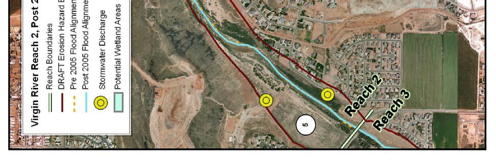
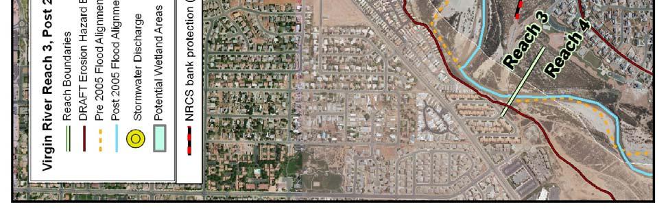
6 Reach 3 This reach includes the river from Washington Fields Drive bridge to the Johnson Diversion. The riparian corridor represented by the EHZ is relatively broad and old meander scars suggest that lateral channel movement is common in this reach. This meander is important to dissipating stream energy and should not be substantially narrowed. The broad corridor provides several areas suitable for habitat enhancement and stormwater treatment. NRCS bank protection is limited to short segments and, in some instances, may increase risk of property damage. Some existing housing lies within the EHZ and is at risk from erosion. 8. The subdivision immediately downstream of Washington Fields Drive bridge lies behind a NRCS levee but at a lower elevation. Should floods overtop the dike, waters separated from the river will flood the area. Flood protection should be increased either through raising of the adjacent levee and/or maintaining adequate conveyance on the opposite floodplain. 9. A connecting road is planned for the right side of the river. The road should not narrow the existing corridor or increase flood potential. There is the potential to create an urban park along/around roadway to maintain flood capacity and meet urban park goals. 10. Floodplain and flood terraces should be maintained to reduce flood risk. 11. Several areas have potential for wetland creation and stormwater treatment. 12. A short buried NRCS levee protects a waterline in this area. However, the levee does not extend to stable structure outside the EHZ. The levee has the potential to trap flows behind it increasing the risk of erosion to adjacent homes inside the EHZ. The lack of vegetation along the pipeline increases the risk of capture by the river. The structure should be extended to the edge of the EHZ. 13. Areas of thick salt cedar should be replaced by appropriate native species especially adjacent to the active stream channel.


7 Figure 4 Reach 3 map
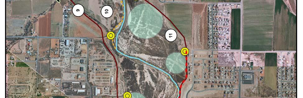
8 Reach 4 This reach includes the river between Johnson Diversion and River Road bridge. The EHZ and riparian corridor is relatively wide. Existing development is discontinuous but the large areas on both sides of the river have potential for development. 14. Infrastructure near or in EHZ is at risk of lateral erosion. Short sections of NRCS levees within reach do not appear to adequately protect existing infrastructure. The structures may increase risk of lateral erosion if flanked by high stream flows. Levees should be extended to the EHZ to protect adjacent properties. 15. Mall Drive bridge is planned for mid-reach (alignment approximate). The bridge spans should be wide enough to allow high flows to spread and should be centered in corridor to allow some continued natural channel meander. 16. Seegmiller Marsh provides potential for wetland creation, stormwater treatment, and recreation. 17. Throughout the reach areas of dense salt cedar should be replanted with appropriate riparian plant communities especially adjacent to the active stream channel. 18. Corridor is narrowed by geologic control (right side) and NRCS levees (left side). Area protected by levee should remain flood terrace and be planted with appropriate native riparian plant species. 19. Open flood terraces should not be developed with hard infrastructure but could be used for parks, golf courses, and other uses where occasional flooding is acceptable. Areas should be planted with appropriate native plant species.

9 Figure 5 Reach 4 map
10 Reach 5 This reach includes the river corridor between River Road and I-15. The River Road bridge creates a narrow constriction upstream but the riparian corridor and EHZ is relatively wide through most of the reach. The multitude of abandoned channel scars suggest that lateral movement is common. Substantial development has taken place within the EHZ on river left (North side) and two short NRCS levees have been installed for erosion protection. The riparian corridor narrows sharply between bedrock hills at the I-15 bridges. 20. River Road bridge creates tight constriction that may cause flooding or erosion along the south approach. 21. Short sections of NRCS levees within reach do not appear to adequately protect existing infrastructure. The structures may increase risk of lateral erosion if flanked by high stream flows. Levees should be extended to the EHZ to protect adjacent properties. 22. If agricultural fields are developed they should be consistent with guidelines and recommendations. 23. Reach areas of dense salt cedar should be replanted with appropriate riparian plant communities especially adjacent to the active stream channel. 24. Removal of large areas of salt cedar within the riparian corridor should be carefully planned and replanted to reduce the risk of stream capture during high flow events. Higher flood terraces could be planted with mesquite and other xeric riparian species. 25. Several areas have potential for wetland creation and stormwater treatment. 26. Ft. Pearce/Santa Clara confluences. Sediment/flood inputs make this area very dynamic with the potential for periodic local aggradation and degradation depending on hydrology and sediment contributions from the three streams. The dynamics increase the potential for unpredictable lateral meander. 27. The planned connection between Dixie Center Drive to Hilton Drive should not reduce width or restrict flow across flood terraces in this critical area.

11 Figure 6 Reach 5 map
12 Reach 6 The reach includes the river between the I-15 bridge and Man of War bridge in Bloomington. The riparian corridor is narrowed by bedrock control and gradually widens downstream. Stream channel is relatively straight following the 2005 flood but can be expected to create meanders over time. The channel/floodplain areas were overexcavated following the 2005 flood and alluvial bars and other features are reforming. Areas to river right (East side) at Man of War bridge experienced flooding during 2005 when overbank flows were redirected away from the river and into neighborhoods. 28. Channel was excavated following the 2005 flood and should be planted with native vegetation to increase stability and discourage reestablishment by dense thickets of salt cedar. 29. Flooding of ball fields leads to drainage away from the river and across Man of War Drive. Topography and/or vegetation should be modified to encourage overbank flows return to the river.


13 Figure 7 Reach 6 map
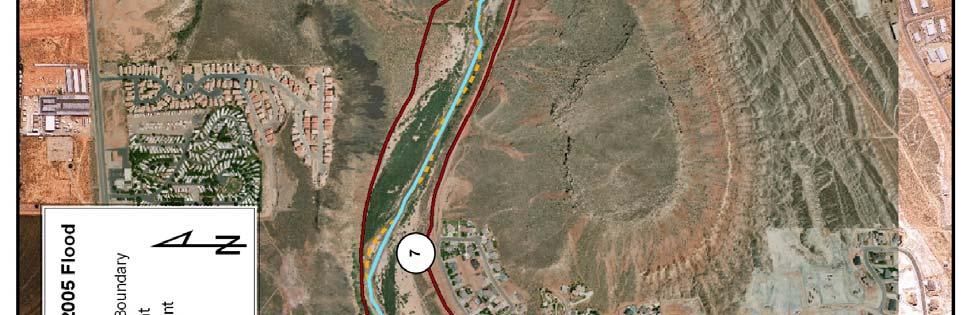
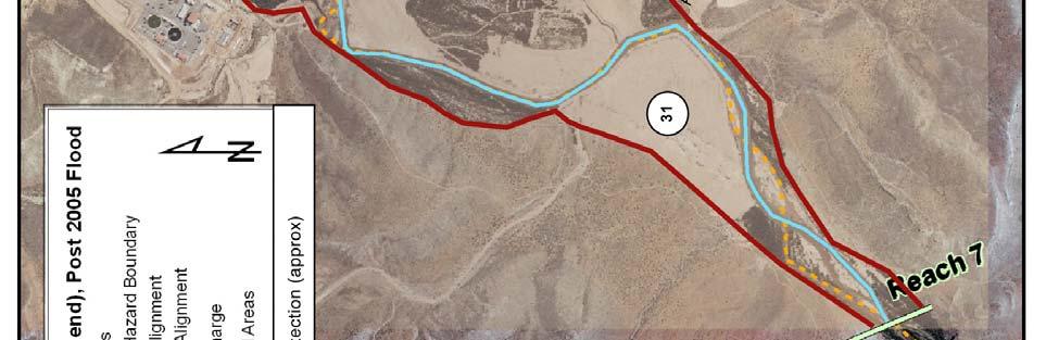
14 Reach 7 The reach includes the river between Man of War bridge and St. George city boundaries downstream of Atkinville Wash. The riparian corridor and EHZ are relatively narrow near Man of War bridge but widen considerably in mid-reach before narrowing as the river enters the bedrock canyon downstream. Scour scars suggest large active historic channel meandering through the wider sections of the reach. NRCS levees were installed along both sides of the river in the developed areas in Bloomington and should reduce the risk of property loss due to lateral migration. However, the levees will not necessarily reduce flood risk. Areas to river right (East side) at Man of War bridge experienced flooding during 2005 when overbank flows were redirected away from the river and into neighborhoods. The golf course at Sun River occupies much of the corridor and EHZ in the lower part of the reach and was flooded during Flooding of ball fields leads to drainage away from the river and across Man of War Drive. Topography and/or vegetation should be modified to encourage overbank flows return to the river. 31. Areas throughout the corridor should be planted with native vegetation to increase stability and discourage reestablishment by salt cedar especially areas adjacent to the active stream channel. Point bars and floodplains should be dedicated to spreading flood flows. Salt cedar thickets should be replaced with appropriate native vegetation whenever possible. 32. Flooding of Sun Valley golf course during 2005 flood resulted in deposition of large volumes of sand. Upstream edge of golf course should be raised to reduce the risk of flooding and/or the course recontoured so that overbank flows are routed through the course to minimize sediment deposition.

15 Figure 8 Reach 7 (upper)

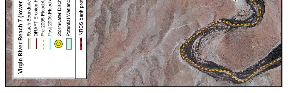
16 Figure 9 Reach 7 (lower)
Santa Cruz River Master Plan. Presented to the Arizona Floodplain Management Association Spring Conference June 8-10, 2011
 Santa Cruz River Master Plan Presented to the Arizona Floodplain Management Association Spring Conference June 8-10, 2011 Introduction Who is FICO? 2 Project Team Kimley-Horn and Associates, Inc. River
Guiding Landowners in Stream Restoration. The Science, Practice & Art of Restoring Native Ecosystems 2015
 Guiding Landowners in Stream Restoration The Science, Practice & Art of Restoring Native Ecosystems 2015 January 24, 2015 Guiding Landowners in Stream Restoration January 24, 2015 Agenda 1Watershed Planning
When planning stormwater management facilities, the following principles shall be applied where possible.
 2.0 Principles When planning stormwater management facilities, the following principles shall be applied where possible. 2.0.1 Drainage is a regional phenomenon that does not respect the boundaries between
ADDENDUM TO BIOLOGICAL SCOPING SURVEY REPORT, BOTANICAL SURVEY AND WETLAND DELINEATION
 ADDENDUM TO BIOLOGICAL SCOPING SURVEY REPORT, BOTANICAL SURVEY AND WETLAND DELINEATION FOR AVALON INN (APN 069-241-27 & -04) 1201 & 1211 NORTH MAIN STREET FORT BRAGG, CA MENDOCINO COUNTY prepared for:
North Branch of Cypress Creek Ecological Restoration: A Comprehensive Approach to Stream Restoration
 North Branch of Cypress Creek Ecological Restoration: A Comprehensive Approach to Stream Restoration Rocky Powell Clear Creeks Consulting, LLC Keith D. Tate, P.E. BayLand Consultants & Designers, Inc.
MCCOYS CREEK RESTORATION 30% DESIGN
 MCCOYS CREEK RESTORATION 30% DESIGN THE MCCOYS CREEK RESTORATION PLAN The restoration plan aims to reduce flooding, restore ecosystem health, expand recreational opportunities along the creek, and connect
Improving Communities Through the Arroyo Seco Sustainability Campaign and Watershed Assessment
 Improving Communities Through the Arroyo Seco Sustainability Campaign and Watershed Assessment Arroyo Seco Headwaters in the San Gabriel Mountains Major tributary to the Los Angeles River 44 square mile
Is a Riparian Restoration Still Viable After 100-year Storm Events Alter the Original Design?
 Is a Riparian Restoration Still Viable After 100-year Storm Events Alter the Original Design? Sarah Spear Cooke, Ph.D. Seattle, Washington Presentation Outline Introduction The site pre-restoration Restoration
Draft Stillwater 2030 Comprehensive Plan- Goals and Policies
 Draft Stillwater 2030 Comprehensive Plan- Goals and Policies Instructions- Review each goal and policy and discuss with group any changes, deletions for additions to the list using your groups pen. Keep
Riparian Buffer on the Bushkill Creek. Policies
 Riparian Buffer on the Bushkill Creek Riparian buffers provide numerous benefits to landowners and the community by protecting groundwater recharge areas, providing flood control, providing stormwater
Urban runoff in my neighborhood (Capitol Hill) is heavy with trash and other debris.
 is heavy with trash and other debris.") South Platte River Meeting Comments & s #1 I am a huge fan of river areas and would love the Platte and surrounding waterways to improve to allow habitat for wildlife and recreation opportunities for citizens.
South Platte River Meeting Comments & s #1 I am a huge fan of river areas and would love the Platte and surrounding waterways to improve to allow habitat for wildlife and recreation opportunities for citizens.
Farmers Investment Co. (FICO) Continental Farms
 Continental Farms") Farmers Investment Co. (FICO) Continental Farms Planning & Zoning Commission Study Session (River Master Plan) January 25, 2012 FICO Property 7,000 acres total area 6,000 acres in Town of Sahuarita 1,000
Farmers Investment Co. (FICO) Continental Farms Planning & Zoning Commission Study Session (River Master Plan) January 25, 2012 FICO Property 7,000 acres total area 6,000 acres in Town of Sahuarita 1,000
LOUISIANA STATE UNIVERSITY COMPREHENSIVE & STRATEGIC CAMPUS MASTER PLAN. APPENDIX G - Stormwater Study Findings & Stormwater Solutions
 LOUISIANA STATE UNIVERSITY COMPREHENSIVE & STRATEGIC CAMPUS MASTER PLAN APPENDIX G - Stormwater Study Findings & Stormwater Solutions LSU: MP Narrative July 2017 3.5 Open Space Existing Conditions The
Tentatively Selected Plan within Harlem River, East River and Western Long Island Sound Planning Region. First Level Costs. Federal Non-Federal Total
 HARLEM RIVER, EAST RIVER AND WESTERN LONG ISLAND SOUND PLANNING REGION Flushing Bay and Creek Ecosystem Restoration Source Feasibility Study Background Study Resolution (1994), Reconnaissance Report (1996),
BASS PONDS, MARSH, & WETLAND HABITAT RESTORATION PROJECT
 FACT SHEET BASS PONDS, MARSH, & WETLAND HABITAT RESTORATION PROJECT MINNESOTA VALLEY NATIONAL WILDLIFE REFUGE, MINNESOTA ENVIRONMENTAL MANAGEMENT PROGRAM LOCATION Three areas located on the Minnesota Valley
The Napa River Flood Protection Project
 The Napa River Flood Protection Project Creating Flood Protection and Restoring Geomorphic and Biological Processes Jeremy Sarrow, Napa County Flood Control & Water Conservation District June 2, 2014.
STREAM BUFFERS
 88-415 STREAM BUFFERS 88-415-01 PURPOSE In the Kansas City region and throughout the nation, vegetated stream buffers have been clearly shown to protect stream stability and related infrastructure, improve
Working Group Meeting
 April 4,, 2017 Parks Operations Bldg Working Group Meeting Arts Districts Overview Stormwater/RPA/Stream Considerations First Principles Agenda 7:00pm 7:05pm 7:10pm 7:40pm 8:30pm 9:40pm 9:45pm Welcome
Presentation to Parks and Open Space Advisory. Committee September 22, 2016
 Flood Planning & Preliminary Design Services for South St. Vrain Creek Restoration at Hall Ranch Presentation to Parks and Open Space Advisory Prepared for: Boulder County, Colorado Committee September
Stormwater Regulations & Considerations Morse Study Area. Pam Fortun, P.E. CFM Senior Stormwater Treatment Engineer Engineering Services Division
 Stormwater Regulations & Considerations Morse Study Area Pam Fortun, P.E. CFM Senior Stormwater Treatment Engineer Engineering Services Division Stormwater Regulations Development Considerations Floodplain
Guidelines for Streambank Protection
 PDHonline Course C187 (3 PDH) Guidelines for Streambank Protection Instructor: John Poullain, PE 2012 PDH Online PDH Center 5272 Meadow Estates Drive Fairfax, VA 22030-6658 Phone & Fax: 703-988-0088 www.pdhonline.org
Mendota Heights 2040 Comprehensive Plan Draft Vers
 4 Parks and Trails The City of Mendota Heights boasts a variety of recreational and open space opportunities. Few cities can claim access to regional trails, riverside and lakeside parks, scenic bluffs
PICTURE CANYON Planning Riparian-Wetland Refugia in an Urban Setting
 PICTURE CANYON Planning Riparian-Wetland Refugia in an Urban Setting Rio De Flag Existing Conditions. Ephemeral stream; Limited riparian plants, habitats.. & Opportunities Water (effluent) available Restore
Appendix E Preliminary Location Hydraulic Study
 Appendix E Prepared for: State of Alaska Department of Transportation and Public Facilities Prepared by: HDR Alaska, Inc. 2525 C Street, Suite 305 Anchorage, Alaska 99503 February 2014 This page intentionally
Request for an Exception to the Napa County Road and Street Standards
 F Request for an Exception to the Napa County Road and Street Standards Shed Creek Winery Use Permit P16-327 and Use Permit Exception to the Conservation Regulations P17-178 Planning Commission Hearing
Rule D Wetland and Creek Buffers
 Rule D Wetland and Creek Buffers 1 Policy It is the policy of the Board of Managers to ensure the preservation of the natural resources, recreational, habitat, water treatment and water storage functions
Restoration in the Sky Islands:
 Restoration in the Sky Islands: Bringing volunteers, landowners, practitioners and agencies together to benefit wildlife and habitats in a global biodiversity hotspot Sky Island Alliance Dedicated to the
Stormwater Standards. Clackamas County Service District No. 1. Planting Guide for Buffers
 Stormwater Standards Clackamas County Service District No. 1 APPENDIX B Planting Guide for Buffers Table of Contents Appendix B - Planting Guide for Buffers... Page B.1 General... 1 B.1.1 Introduction...
Big Thompson River Restoration Master Plan. Stakeholder Kick off Meeting and Workshop April 12, 2014
 Big Thompson River Restoration Master Plan Stakeholder Kick off Meeting and Workshop April 12, 2014 AGENDA 1:30 to 2:10 Information 2:10 to 2:35 Questions 245t 2:45 to 4:00 400 Worksession in Cafeteria
FURNEAUX CREEK 5 CHANNEL
 FURNEAUX CREEK 5 CHANNEL AND TRAIL IMPROVEMENTS TEXAS CHAPTER AMERICAN PUBLIC WORKS ASSOCIATION PROJECT OF THE YEAR CATEGORY: ENVIRONMENT PROJECT OF $2 MILLION BUT LESS THAN $5 MILLION ENGINEERING DEPARTMENT,
City of Shady Cove Riparian Ordinance Ordinance XXX
 1 Updated October 8, 2015 City of Shady Cove Riparian Ordinance Ordinance XXX This language is to be located in Chapter 155 of the Shady Cove Code of Ordinances. This will affect property inside city limits,
Chapter 3 Site Planning and Low Impact Development
 CHAPTER 3 Site Planning and Low Impact Development Chapter 3 Site Planning and Low Impact Development 3.0 Introduction The City of Charleston requires that major residential, large commercial (>1 acre),
Lincoln 270. City of Lincoln. Stormwater Management Plan. April 2, 2013
 Lincoln 270 City of Lincoln Stormwater Management Plan April 2, 2013 # 2005.48 Prepared By: Civil Engineering Solutions, Inc. 590 E Street Lincoln, Ca 95648 (916) 645 5700 1.0 Background: The project site
Parks, Recreation, and Open Space Land Use Goals
 Parks, Recreation, and Open Space Land Use Goals Issue: The preservation of open space and natural features will enhance the character of the built environment, promote public health and safety, provide
PERMANENT SEEDING. Overview of Sedimentation and Erosion Control Practices. Practice no. 6.11
 Overview of Sedimentation and Erosion Control Practices Practice no. 6.11 PERMANENT SEEDING Permanent vegetation controls erosion by physically protecting a bare soil surface from raindrop impact, flowing
Department of Agriculture. Conservation Service. United States. Natural Resources REVISED 8/26/16
 GENERAL NOTES: SYMBOL LEGEND 1. All work shall comply with the constriction specifications, drawings, project-specific quality assurance plan and other contract requirements. 2. All notes on the drawings
Washington County, Maryland Division of Public Works Policy Manual
 Washington County, Maryland Division of Public Works Policy Manual Subject: Downstream Drainage Easement Category: Land Development Engineering Number: 7-4.1 Date: June 1, 2009 (effective) PURPOSE: The
STREAM BANK STABILIZATION THORPS MORTIMER RECREATION AREA Grandfather Ranger District SITE LOCATION & DRAINAGE AREA
 STREAM BANK STABILIZATION THORPS CREEK @ MORTIMER RECREATION AREA SITE LOCATION & DRAINAGE AREA SITE LOCATION Drainage Area = 1.14 sq. miles STREAM BANK STABILIZATION THORPS CREEK @ MORTIMER RECREATION
Holland Country Club Golf Course to Wetlands
 Holland Country Club Golf Course to Wetlands John Scholtz, Director Ottawa County Parks & Recreation Commission Amy A. Berry, Project Manager Niswander Environmental, LLC OTTAWA COUNTY PARKS: Focusing
Don Narrows Workshop DRAFT MEETING REPORT Saturday, May 24, 2008 South Regent Park Recreation Centre
 Don Narrows Workshop DRAFT MEETING REPORT Saturday, May 24, 2008 South Regent Park Recreation Centre Introduction to the Workshop & this Report On Saturday, May 24, 2008 Toronto and Region Conservation
Zoning Ordinance Article 3
 Article 3 Natural Resources Protection Section 301 Natural Resources Protection 301.1. Purpose - The following natural resources protection standards are established to protect the public health, safety
6Natural. Environment Development Permit Guidelines
 6Natural Bylaw 2600-2016, being "Official Community Plan Bylaw, 2016" Schedule "A" CITY OF ABBOTSFORD OFFICIAL COMMUNITY PLAN Environment Development Permit Guidelines Part V - 6-1 Area Subdivision or
Farmers Investment Co. (FICO) Sahuarita Farms Specific Plan & Minor General Plan Amendment Community Meeting July 1, 2014
 Sahuarita Farms Specific Plan & Minor General Plan Amendment Community Meeting July 1, 2014") Farmers Investment Co. (FICO) Sahuarita Farms Specific Plan & Minor General Plan Amendment Community Meeting July 1, 2014 FICO / Property Overview FICO Properties 7,000 Acres Total 5,900 Acres in Town
Farmers Investment Co. (FICO) Sahuarita Farms Specific Plan & Minor General Plan Amendment Community Meeting July 1, 2014 FICO / Property Overview FICO Properties 7,000 Acres Total 5,900 Acres in Town
Outfall Reconnaissance Inventory & Stream Assessment
 CITY OF TUMWATER Outfall Reconnaissance Inventory & Stream Assessment City of Tumwater 555 Israel Road SW Tumwater, WA 98501 ACKNOWLEDGEMENTS City of Tumwater Outfall Reconnaissance Inventory and Stream
Erosion & Sediment Control Plan Application Form & Checklist
 Erosion & Sediment Control Plan Application Form & Checklist GENERAL INFORMATION Application Date: Project Address: Tax Map / Parcel Number(s): PROPERTY OWNER / DEVELOPER Firm Name: Contact Person: Title:
Craven Street Stormwater Improvement Projects
 Craven Street Stormwater Improvement Projects The Craven Street Watershed drains the area from Haywood Road to Westwood Place and down Haywood to the French Broad River. The watershed has one main un-named
WQ-23 MOUNTAINOUS AND STEEP SLOPE SITES
 Greenville County Technical Specification for: WQ-23 MOUNTAINOUS AND STEEP SLOPE SITES 1.0 Mountainous and Steep Slope Sites 1.1 Description The geographic locations of portions of Greenville County are
RAIN GARDEN ILLINOIS URBAN MANUAL PRACTICE STANDARD. (feet) CODE 897 DEFINITION
 CODE 897 DEFINITION") ILLINOIS URBAN MANUAL PRACTICE STANDARD RAIN GARDEN (feet) CODE 897 Source: Kendall County Soil and Water Conservation District DEFINITION Rain gardens are small, shallow, flat bottomed depressions constructed
ILLINOIS URBAN MANUAL PRACTICE STANDARD RAIN GARDEN (feet) CODE 897 Source: Kendall County Soil and Water Conservation District DEFINITION Rain gardens are small, shallow, flat bottomed depressions constructed
Kootenai River Habitat Restoration Program June 18, 2018 Kootenai Valley Resource Initiative Update
 Kootenai River Habitat Restoration Program June 18, 2018 Kootenai Valley Resource Initiative Update Kootenai River Habitat Restoration Program Multi-year habitat restoration program Restoration treatments
ST. MARY S SOIL CONSERVATION DISTRICT (SMSCD) AND DPW&T CONCEPT EROSION AND SEDIMENT CONTROL AND STORMWATER MANAGEMENT GUIDELINES AND CHECKLIST
 AND DPW&T CONCEPT EROSION AND SEDIMENT CONTROL AND STORMWATER MANAGEMENT GUIDELINES AND CHECKLIST") St. Mary s Soil Conservation District 26737 Radio Station Way, Suite B Leonardtown, MD 20650 Phone: 301-475-8402 ext. 3 Fax: 301-475-8391 www.stmarysscd.com St. Mary s County Government Department of Public
St. Mary s Soil Conservation District 26737 Radio Station Way, Suite B Leonardtown, MD 20650 Phone: 301-475-8402 ext. 3 Fax: 301-475-8391 www.stmarysscd.com St. Mary s County Government Department of Public
Parks, Trails, and Open space Element
 Parks, Trails, and Open space Element Parks, Trails, and Open Space element Parks, Recreation, and Open Space are important components of the quality of life desired by the residents of Elk Grove. This
CRESCENT PARK GREENWAY VISION
 CRESCENT PARK GREENWAY VISION City of Hillsboro Trails Master Plan CRESCENT PARK GREENWAY Members of the Hillsboro community came together to determine the following vision and goals for the Crescent Park
Post Construction BMPs
 Post Construction BMPs Why are Post Construction BMPs important? With increased development brings the increase of impervious cover Parking lots, rooftops, driveways Storm water runoff volume increases
APPENDIX F: EXTERNAL APPROVALS
 1.0 RESPONSIBILITIES When the City is constructing the Park or Open Space Development lands (OPTION I), after the subdivision construction process is completed by the Developer, Open Space Development
River Corridor Overlay Zone (RCOZ) Article 5
 Article 5") River Corridor Overlay Zone (RCOZ) Article 5 The site is in one of two designated districts. The first is the CBD (central business district) River District, which recognizes the urban character and unique
River Corridor Overlay Zone (RCOZ) Article 5 The site is in one of two designated districts. The first is the CBD (central business district) River District, which recognizes the urban character and unique
A: Downtown Diversion Pipe
 A: Downtown Diversion Pipe b c with modifications Map highlighting conservation easement. The diversion pipe would run along the railroad. Will divert 40-44% of total flow.; and Reduce the impact on Sand
Chapter 5: Natural Resources and Environment
 NATURAL RESOURCES AND ENVIRONMENT 5-1 5 Chapter 5: Natural Resources and Environment BACKGROUND AND INTENT Urban expansion represents the greatest risk for the future degradation of existing natural areas,
TRCA Field Staking Protocol December 2016
 Page 1 of 6 TRCA Field Staking Protocol December 2016 This Protocol describes TRCA staff s current practice for field staking the physical top of bank, the physical toe of slope, and the limit of existing
Stream Corridor Management Plan
 Stream Corridor Management Plan A unified and comprehensive approach to protecting, restoring and managing the Upper Delaware River Graydon Dutcher Delaware County Soil and Water Conservation District
Public Meeting for the Redevelopment of. July 17,2018 7pm to 9pm Rolling Knolls Elementary School
 Public Meeting for the Redevelopment of July 17,2018 7pm to 9pm Rolling Knolls Elementary School Meeting Agenda Welcome/ Community Meeting Key Project Information History - Damian Cosby, DRP- Chief of
Banking on Natural Fibers Products made from coir and jute play a key role in stabilizing a restored stream for a commercial stream mitigation bank.
 Banking on Natural Fibers Products made from coir and jute play a key role in stabilizing a restored stream for a commercial stream mitigation bank. By Greg Northcutt When White Creek Mitigation, LLC,
Caledon Villas Corp. c/o Mr. John Spina 55 Blue Willow Drive Woodbridge, ON L4L 9E8 May 14, Floodplain Characteristics, Old Church Road
 Caledon Villas Corp. c/o Mr. John Spina 55 Blue Willow Drive Woodbridge, ON L4L 9E8 May 14, 2013 Re: Floodplain Characteristics, Old Church Road This letter serves to confirm that I, Linda Sober, have
Los Angeles River-Arroyo Seco Confluence Restoration Vision Plan. Professor Meredith McKenzie, JD Urban & Regional Planning Dept Cal Poly Pomona
 Los Angeles River-Arroyo Seco Confluence Restoration Vision Plan Professor Meredith McKenzie, JD Urban & Regional Planning Dept Cal Poly Pomona The Los Angeles River Watershed Arroyo Seco Watershed Map
Description of Preferred Alternative
 Chapter 2 Description of Preferred Alternative 2.1 Introduction This chapter of the programmatic Sammamish Town Center Sub-area Plan Final EIS provides a more detailed description of the Preferred Alternative
Caribbean Area PO Box San Juan, PR Page Topics
 Caribbean Area PO Box 364868 San Juan, PR 00936-4868 IBM Plaza 654 Muñoz Rivera Ave. Suite 604 Hato Rey, PR 00918-4123 Page Topics Guide to Erosion and Sediment Control in Urban Areas Erosion and Sedimentation
APPENDIX A SIMPLIFIED APPROACH TO STORMWATER MANAGEMENT FOR SMALL PROJECTS. In West Sadsbury Township, Chester County, Pennsylvania
 APPENDIX A SIMPLIFIED APPROACH TO STORMWATER MANAGEMENT FOR SMALL PROJECTS In West Sadsbury Township, Chester County, Pennsylvania TABLE OF CONTENTS I. Introduction 3 II. Importance of Stormwater Management
Section 3 Non-Structural BMPs
 3.1 Stream Buffers A stream buffer or stream setback is a designated area around a stream, lake, or wetland left in a natural, densely vegetated state so as to protect the receiving water quality and provide
Weston s Wetlands, Stormwater, & Open Space
 Weston s Wetlands, Stormwater, & Open Space Weston s Wetlands, Stormwater, & Open Space Conservation Commission Role and Responsibilities Laws that protect wetlands What residents can do to protect wetlands
Worksheet #14 Water Runoff Management
 Water Runoff Management Use this worksheet to assess how well your property minimizes the potential for water runoff and property damage.. Why should you be concerned? What can you do? Rural runoff, also
NORTH DISTRICT. Description
 VI plan and major recommendations district plans north disrict NORTH DISTRICT Description The North District comprises approximately 105 acres and is bounded by two important bio-habitats and corridors
Checklists. Project Name: Location: File Number: Date of Submittal: Reviewer: Date: Applicant: Contact Name: Phone Number:
 Applicant: Contact Name: Phone Number: Email: Project Name: Location: File Number: Date of Submittal: Reviewer: Date: Concept Plan Requirements: I. General Project Information 1. Address or parcel number
Stream Restoration: Working with Nature?
 Stream Restoration: Working with Nature? Greg Jennings, PhD, PE jenningsenv@gmail.com Ecosystem Restoration activities that initiate or accelerate the recovery of ecosystem health, integrity, and sustainability
Stream Restoration: Working with Nature? Greg Jennings, PhD, PE
 Stream Restoration: Working with Nature? Greg Jennings, PhD, PE jenningsenv@gmail.com Ecosystem Restoration activities that initiate or accelerate the recovery of ecosystem health, integrity, and sustainability
East Montpelier SWMP Preliminary BMP Summary Sheet BMP ID #: 1 Site name: U-32 High School. Current site type
 East Montpelier SWMP Preliminary BMP Summary Sheet BMP ID #: 1 Site name: U-32 High School 930 Gallison Hill Rd, East Montpelier, VT Filter Berm, Sand Filter, Cistern / Rain Barrel, Gravel Wetland, Check
Level 1 Downstream Analysis
 Level 1 Downstream Analysis Newcastle Way Apartments Newcastle, Washington King County April 14, 2014 Revised July 10, 2014 Prepared by: Dean A. Furr, P.E. Reviewed by: Donald Scarberry, P.E. Coffman Engineering,
Richton Park Western Development Corridor Green Infrastructure Development Plan August 18, 2017
 Richton Park Western Development Corridor Green Infrastructure Development Plan August 18, 2017 Conservation Design Forum Geosyntec Consultants 403 W. St. Charles Road 1420 Kensington Road, Suite 103 Lombard,
Urban Conservation Practice Physical Effects ESTABLISHMENT, GROWTH, AND HARVEST NUTRIENT MANAGEMENT
 NOT WELL 800 - Urban Stormwater Wetlands A constructed system of shallow pools that create growing conditions for wetland plants to lessen the impacts of stormwater quality and quantity in urban areas.
SECTION 6. Routine Maintenance Activity Details
 SECTION 6 Routine Maintenance Activity Details 80. DEBRIS REMOVAL When Deadfall, and other objects, such as shopping carts, tires, appliances, and mattresses have accumulated in the drain. Why To prevent
FURTHER TO EXECUTIVE COMMITTEE MEETING #11/12 To be held on Friday, January 11, 2013
 FURTHER TO EXECUTIVE COMMITTEE MEETING #11/12 To be held on Friday, January 11, 2013 FURTHER TO: Pages EX10. APPLICATION FOR PERMITS UNDER ONTARIO REGULATION 166/06 Development, Interference with Wetlands
Berkshire Regional Planning Commission Clearinghouse Review Report
 August 19, 2013 SUBJECT: Reconstruction of Housatonic Street, Dalton, MA EOEA#: 15083 LOCATION: Dalton ESTIMATED COST: $8.1 million REVIEW TYPE: ENF PROPONENT: MassDOT and Town of Dalton COMMENTS DUE:
Vegetating Disturbed Road & Stream Banks. By Mike Fournier NRCS Resource Conservationist
 Vegetating Disturbed Road & Stream Banks By Mike Fournier NRCS Resource Conservationist Clearly Identify The Problem Project Objectives Clearly Define Objectives Before Work Starts Determine Whether Project
Design Considerations for Open Channel and Detention Pond Design. Howard Redfearn, City of Mansfield
 Design Considerations for Open Channel and Detention Pond Design Howard Redfearn, City of Mansfield Previous Experience/Criteria/Maintenance Issues New Criteria Discussion Overview Where is Mansfield?
Study Area Map. Wasatch Hollow Open Space Restoration, Use, & Management Plan. Legend. Harrison Ave East. Roosevelt East.
 Harrison Ave Roosevelt Emerson «4 «5 Rosecrest 1900 East «3 1800 East Wasatch Hollow Open Space Restoration, Use, & Management Plan Study Area Map Legend «2 «1 Potential Access Location Emigration Creek
Existing Conditions and Environmental Consequences Floodplains
 3.9 Environmental Consequences 3.8 3.8.1 WHAT ARE FLOODPLAINS? are low-lying areas adjacent to rivers, streams, and other waterbodies that are susceptible to inundation (flooding) during rain events. These
5. LOW IMPACT DEVELOPMENT DESIGN STANDARDS
 5. LOW IMPACT DEVELOPMENT DESIGN STANDARDS Low Impact Development (LID) requires a shift in stormwater management away from conveying runoff to a small number of downstream points through hydraulically
Parks, Trails, and Open Space Element
 P arks, Recreation, and Open Space are important components of the quality of life desired by the residents of Elk Grove. This Element of the General Plan addresses the City s goals, policies, and actions
MRCCA PRIMARY CONSERVATION AREAS
 MRCCA PRIMARY CONSERVATION AREAS LOCAL PLANNING HANDBOOK INTRODUCTION MRCCA plans must identify and protect primary conservation areas (PCAs). Primary Conservation Areas (PCAs) are defined in the MRCCA
Town of Vershire Road Erosion Inventory Report
 Town of Vershire Road Erosion Inventory Report Taylor Valley Road. Photo taken by TRORC staff. Prepared by: 128 King Farm Road Woodstock, VT 05091 Inventory and report funded by the Vermont Agency of Transportation
One County s Success in Linking Watershed Protection and Land Use Planning
 One County s Success in Linking Watershed Protection and Land Use Planning Bob Thompson Porter County Plan Commission March 28, 2012 Indiana Watershed Leadership Academy Population 160,000 Approximately
Storm Water Quality and Shoreline Restoration Improvements - Grant Funding Request City of Mound Carlson Park Bolton & Menk Project No.
 September 15, 2016 Brett Eidem Cost Share Grant Administrator Minnehaha Creek Watershed District 15320 Minnetonka Boulevard Minnetonka, MN 55345 RE: Storm Water Quality and Shoreline Restoration Improvements
The use of low head weirs to. perennial streams with their floodplains:
 The use of low head weirs to reconnect severely entrenched perennial streams with their floodplains: An Anne Arundel County TMDL Watershed Implementation Plan Strategy presented by Hala Flores, P.E Mid
Surrey Ecosystem Management Study
 Surrey Ecosystem Management Study Green Infrastructure Network Opportunities Public Open House & Information Session June 24 th, 2010 EMS Process Ecological Inventory Ecological Assessment Management Policy
Principles for Ecological Landscape Design in Brownfield Business Parks
 Principles for Ecological Landscape Design in Brownfield Business Parks Part of USDA Forest Service research project # 00-JV-11231300-033: Aligning Social and Ecological Drivers of Urban Landscape Change
4.6. Low Impact and Retentive Grading
 4.6. Low Impact and Retentive Grading Low Impact Grading techniques focus on utilizing existing topography during Site layout to minimize cost. Proposing structures, roads, and other impervious surfaces
SOUTH FOX MEADOW STORMWATER IMPROVEMENT PROJECT
 VILLAGE OF SCARSDALE WESTCHESTER COUNTY, NEW YORK COMPREHENSIVE STORM WATER MANAGEMENT SOUTH FOX MEADOW STORMWATER IMPROVEMENT PROJECT In association with WESTCHESTER COUNTY FLOOD MITIGATION PROGRAM Rob
B - Coalfield River Corridor Landscape Character Type
 B - Coalfield River Corridor Landscape Character Type Landscape Character Type - Coalfield River Corridor The Coalfield River Corridors Landscape Character Type is located in the two converging valleys
HUDSON VALLEY REGIONAL COUNCIL 3 Washington Center, Newburgh NY
 PROJECT AREA: HYDE PARK HUDSON VALLEY REGIONAL COUNCIL 3 Washington Center, Newburgh NY 12550 http://www.hudsonvalleyregionalcouncil Insert aerial site photo with streets labeled GREEN INFRASTRUCTURE CONCEPT
Problem Understanding
 Introduction...2-1 Previous Data and Mapping...2-2 Known Problem Areas...2-3 Resident Survey.2-3 Introduction The Village of Downers Grove stormwater system includes storm sewers, streams, wetlands, roadway
WELCOME! 8 8:30 6: TH STREET IMPROVEMENTS. Open House. Presentation & Q&A
 WELCOME! 168 TH STREET IMPROVEMENTS 6:30 Open House 7 8 Presentation & Q&A 8 8:30 Open House WELCOME Todd Pfitzer City of Omaha Engineer Bob Stubbe City of Omaha Public Works Director Jon Meyer Project
APPENDIX K WINDSOR OFFICIAL PLAN
 CEAA ENVIRONMENTAL ENVIRONMENTAL IMPACT ASSESSMENT AMBASSADOR BRIDGE ENHANCEMENT PROJECT Replacement Span and Plaza Expansion APPENDIX K WINDSOR OFFICIAL PLAN Avalon Consulting Professionals of Ontario,