CITY OF INVER GROVE HEIGHTS A G E N D A CITY COUNCIL WORK SESSION June 3, :00 PM INVER GROVE HEIGHTS CITY HALL COUNCIL CHAMBERS
|
|
|
- Flora Wood
- 5 years ago
- Views:
Transcription

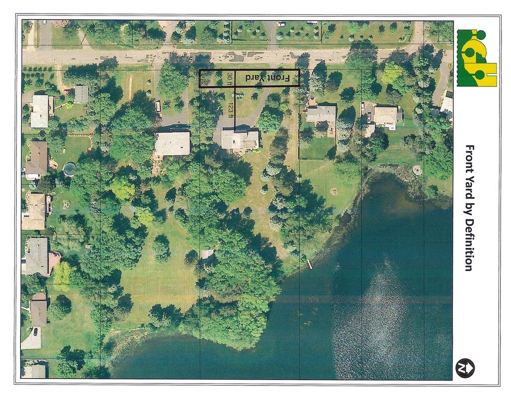
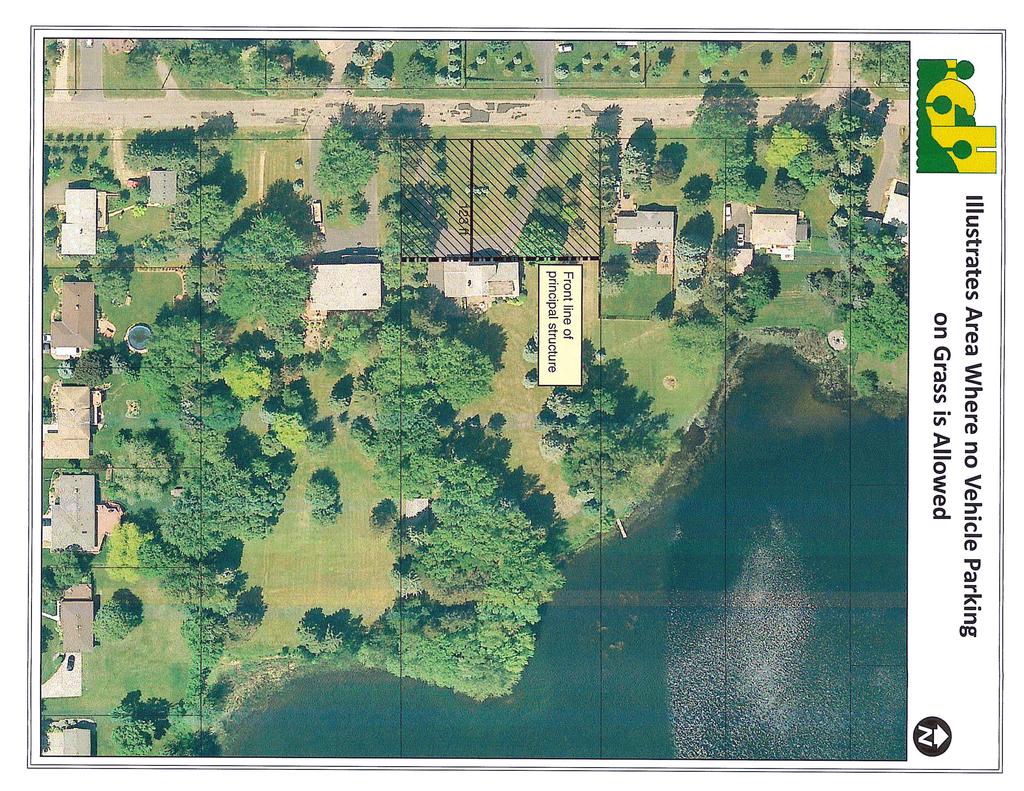
1 CITY OF INVER GROVE HEIGHTS A G E N D A CITY COUNCIL WORK SESSION June 3, :00 PM INVER GROVE HEIGHTS CITY HALL COUNCIL CHAMBERS 1. CALL TO ORDER Mayor Tourville 2. RENTAL REGULATIONS 3. FRONT YARD PARKING 4. INVER GLEN SCHEMATIC DESIGN 5. CITY CAMPUS 6. ADJOURN
2
3
4
5
6
7
8
9
10
11
12
13
14
15
16
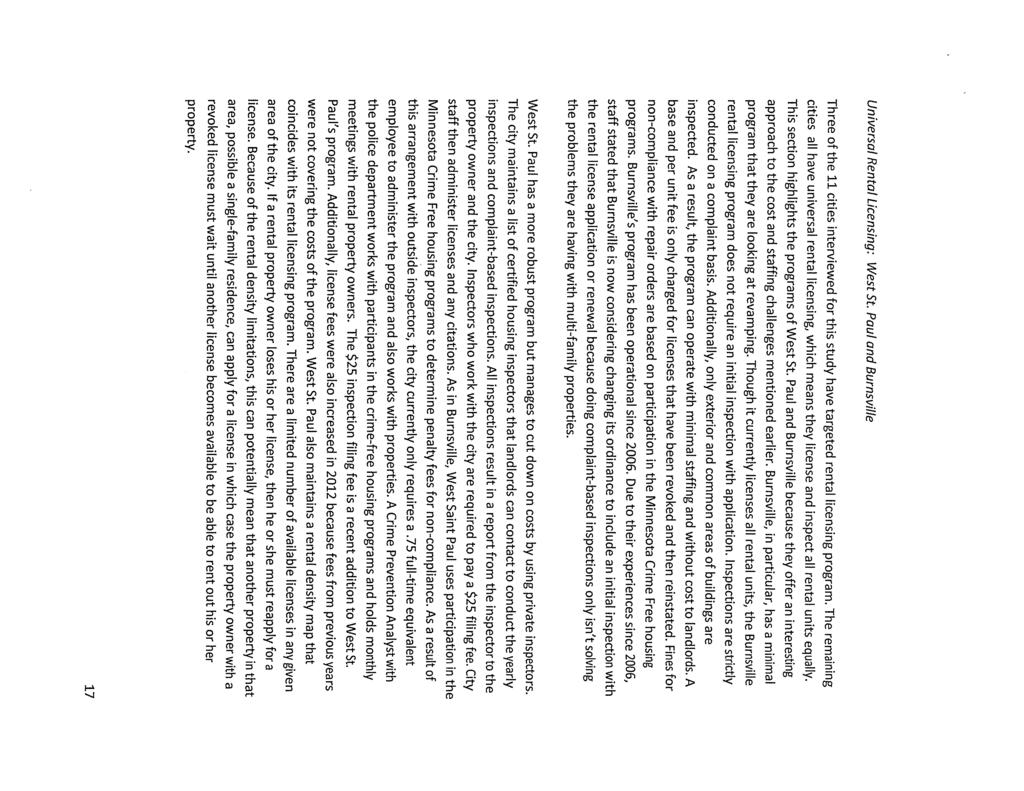
17
18
19
20
21
22
23
24
25
26
27
28
29
30
31
32
33
34
35
36
37
 Babcock Trail Playground Screening Skate Park Art Walk Barbara Ave Police City Hall Public Works Fuel New Trail")
38 Draft Maintain Existing Preferred Access 80th Street Armory VMCC Parking Deck (+ ~50) Babcock Trail Playground Screening Skate Park Art Walk Barbara Ave Police City Hall Public Works Fuel New Trail Loop Intersection Entry Sign Barnes Ave Electronic Sign Wayfinding Sign Natural Path Sidewalk Tree Groves Boulevard Trees New Pond Improvements:» 1st Phase of parking deck» Implement signage plan» Multi-use trail loop along Babcock Trail to existing trail along ponds» Develop art walk along trail to skate park Coordinate:» Funeral home relocation» Barnes Avenue intersection with Dakota Co.» Additional 80th Street intersection -orrelocation with Dakota Co.» Integrate long term plans for the church with vision for business park area west of Babcock Trail Inver Grove Heights City Campus City of Inver Grove Heights Short Term
 Playground City")

39 Draft Alternate Relocated Access If deemed necessary by Dakota Co. Right-in/Right-out Maintain Existing Preferred Access 80th Street * Potential Relocation Site for Funeral Home Armory VMCC Views into Campus Stormwater Additional Parking (+ ~70) Playground City Owned Babcock Trail New Preferred Access Part of Planned Business Park Street Connection? Skate Park Multi-Use Trail / Police Access to West Parking Court Police City Hall Church Expansion? Public Works New Bldg. Access Fuel Existing Parking Stormwater & Utility Screening Multi-Use Trail along Barnes Avenue Barnes Ave Intersection Entry Sign Electronic Sign Wayfinding Sign Natural Path Sidewalk Tree Groves Boulevard Trees New Pond Improvements:» Barnes Avenue intersection» Additional parking at funeral home site» Change south segment of Barbara Avenue to multi-use trail/police access to west» Parking court at police station» Stormwater & views into site from NE corner» Stormwater south of Police Station Coordinate:» Public Works expansion needs» Integrate long term plans for the church with vision for business park area west of Babcock Trail Inver Grove Heights City Campus City of Inver Grove Heights Mid Term
")


40 Draft Maintain Existing Preferred Access 80th Street Armory VMCC Parking Deck Expansion (+ ~100) Road Relocation Babcock Trail Playground Plaza Skate Park City Hall Police Public Works Fuel Public Works Expansion area Barnes Ave Intersection Entry Sign Public Works Expansion area or Office Development Electronic Sign Wayfinding Sign Natural Path Sidewalk Tree Groves Boulevard Trees New Pond Improvements:» Extend parking ramp» Relocate Barbara Avenue» Create public plaza area» Acquisition and expansion opportunities south between public works and existing IGH owned parcel Coordinate:» Development of business park to the west» Public Works expansion needs and potential redevelopment sites to the south Inver Grove Heights City Campus City of Inver Grove Heights Long Term

 Stormwater Pond Road Relocation Babcock")

 Parking")


» Relocation of")


41 Draft Alternate Relocated Access If deemed necessary by Dakota Co. Right-in/Right-out Maintain Existing Preferred Access 80th Street Views into Campus (- ~20) *Potential Relocation Site for Funeral Home Armory VMCC Parking Deck Expansion (+ ~150) Stormwater Pond Road Relocation Babcock Trail Trail Loop Playground Plaza Additional Parking (+ ~70) City Owned Screening New Preferred Access Part of Planned Business Park Street Connection? Skate Park Multi-Use Trail / Police Access to West (- 40 overflow) Parking Court Police City Hall Church Expansion? Public Works New Bldg. Access Fuel Existing Parking Stormwater & Utility Screening Public Works Expansion area Multi-Use Trail along Barnes Avenue Barnes Ave Intersection Entry Sign Public Works Expansion area or Office Development Trail Loop Electronic Sign Wayfinding Sign Natural Path Sidewalk Tree Groves Boulevard Trees New Pond Key Elements:» Parking Ramp (2 phases)» Relocation of Barbara Avenue» Barnes Avenue Access» Parking Court at Police Station» Funeral Home Relocation» Enhanced wayfinding and signage» Public Works Expansion to South» Expanded Trail Loops and Network» Separation of Industrial Trips (public works and Armory/VMCC loading areas» Additional/Improved public spaces (plaza, art walk) Inver Grove Heights City Campus City of Inver Grove Heights Master Plan
ARGENTA TRAIL (CSAH 28/63) REALIGNMENT SOUTH PROJECT (CP 63-25)
 REALIGNMENT SOUTH PROJECT (CP 63-25)") ARGENTA TRAIL (CSAH 28/63) REALIGNMENT SOUTH PROJECT (CP 63-25) Preliminary Design Report February 2015 Prepared For: City of Inver Grove Heights Dakota County Prepared By: Kimley-Horn and Associates,
ARGENTA TRAIL (CSAH 28/63) REALIGNMENT SOUTH PROJECT (CP 63-25) Preliminary Design Report February 2015 Prepared For: City of Inver Grove Heights Dakota County Prepared By: Kimley-Horn and Associates,
Lone Oak Road/ 70 th Street West. Efficient, Effective, Responsive. Preliminary Design Services (CP 26-54)
") (CP 26-54) Dakota County Board of Commissioners September 12, 2017 Purpose of Request Award Design Contract to Kimley-Horn and Associates Approve Joint Powers Agreements with the Cities of Eagan and Inver
(CP 26-54) Dakota County Board of Commissioners September 12, 2017 Purpose of Request Award Design Contract to Kimley-Horn and Associates Approve Joint Powers Agreements with the Cities of Eagan and Inver
Mary Hills Nature Area. Roadway Lighting. The Minneapolis Clinic of Neurology Courage Kenny Rehabilitation Institute
 PUBLIC REALM IMPROVEMENTS Mary Hills Nature Area Enhanced Programming Glenview Terrace Valley View Roadway Lighting Enhanced Streetscape Trail Lighting / Roadway Lighting Wayfinding Public Art The Minneapolis
Elm Street Business District: Streetscape and Signage Plan
 Elm Street Business District: Streetscape and Signage Plan VILLAGE OF WINNETKA DOWNTOWN MASTER PLAN VILLAGE COUNCIL MEETING Final Streetscape & Signage Planning Teska Associates 04 June 2018 WHY WE RE
SOUTHEAST SPORTS COMPLEX MASTER PLAN
 REPORT TO SOUTHGATE NEIGHBORHOOD COUNCIL APRIL 13, 2016 Visioning Process April 30: Stakeholder Meeting with Sports Groups May 5: Stakeholder Meeting with Southgate Land Use Committee May 13: SNC Meeting
The University District envisions, in its neighborhood
 Envisioning the University District Link Light Rail in Seattle s neighborhoods CIY OF SEALE CONCEP-LEVEL SAION AREA PLANNING RECOMMENDAION RESOLUION # 30165 EXHIBI L Vision 08.2000 he University District
Please see attached for more detailed project information. Project Schedule Designer Award by SBC Executive Sub-Committee December 21, 2015
 Project Title Campus Beautification Projects Volunteer Blvd Ph 1 540/009-08-2015 Institution Description UT Knoxville This project will improve Volunteer Boulevard from West Cumberland Ave. to East Cumberland
Transportation. Strategies for Action
 Transportation A major priority for the Overlake Neighborhood is to develop a multimodal transportation system. To achieve this system, a balance has to be found among travel, circulation and access needs;
Rich Valley Greenway Master Plan. Central Greenway Connectivity Study
 Rich Valley Greenway Master Plan Central Greenway Connectivity Study Dakota County Planning Commission February, 2017 Rich Valley Greenway Master Plan Dakota County Greenway Vision Establish a County-wide
38 Queen s University Campus Master Plan Part 1
 38 Queen s University Campus Master Plan Part 1 46 The Campus at the City Scale Chapter 4 The Campus at the City Scale 39 Queen s is an urban University centrally located in Kingston. Decisions made by
COUNTY COURT HOUSE REDEVELOPMENT AREA PLAN
 COUNTY COURT HOUSE REDEVELOPMENT AREA PLAN March 2005 CITY OF TRENTON DEPARTMENT OF HOUSING AND ECONOMIC DEVELOPMENT TABLE OF CONTENTS A. DESCRIPTION...3 1. BOUNDARIES OF PROJECT...3 2. REDEVELOPMENT PLAN
New Park / Entry Court & Plaza Concept Design
 New Park / Entry Court & Plaza Concept Design The SECC Public realm is proposed to have a focus on health, wellness, and community and that site users will include patrons of the neighbourhood. The block
The site to the south of Tanana Loop, east of the Botanical Gardens was evaluated but deemed too small for the array size required.
 Site Consideration This site was chosen for three main reasons: 1) The array is large and needed an accessible piece of land that could physically accommodate it; 2) The site is ideal for its gentle unobstructed
ROME WATERFRONT VILLAGE PROJECT NARRATIVE January 25, 2018
 January 25, 2018 The Rome Waterfront Village project is intended to foster the revitalization of the area between South James Street and Erie Boulevard north of the Erie Canal as well as improve public
Welcome. Comprehensive Plan & Transportation Plan Open House November 7, 2012
 Welcome Comprehensive Plan & Transportation Plan Open House November 7, 2012 Agenda Proposed future land use plan Comprehensive Plan strategies Traffic forecasts Future traffic operations Possible future
Planning Board Briefing
 Planning Board Briefing Why Now? The Sector Plan Implementation Chapter States: Before Stage 1 begins, the following must occur: Approval of the Sectional Map Amendment. Approval of the Greater Lyttonsville
Draft Master Plan for Franklin Park
 Draft Master Plan for Franklin Park Metro Parks Tacoma with SiteWorkshop November 2009 I. overview & background Process & History Master Plan Process The Master Plan is based on a community involvement
4.1.A NORTHWEST QUADRANT MASTER PLAN
 4.1.A NORTHWEST QUADRANT MASTER PLAN (Ordinance 0-16-27, dated October 17, 2016) Goal: Transform the Northwest Quadrant into the cultural centerpiece of Deerfield. Objectives: 1. Maintain the cluster of
Planning Commission March 14, Presented by: City of Bellingham Port of Bellingham
 Planning Commission March 14, 2013 Presented by: City of Bellingham Port of Bellingham 1 Agenda Waterfront District Background Waterfront District Proposal Overview Sub-area Plan Development Regulations
FUTURE LAND USE ELEMENT
 FUTURE LAND USE ELEMENT GOAL I: To create and sustain a great place to live, play, and prosper Objective 1: The City of Ocala shall incorporate the principles and strategies of the Ocala 2035 Vision into
The Atlanta BeltLine. Quarterly Briefing March @atlantabeltline. Reynoldstown Senior Affordable Housing
 The Atlanta BeltLine Quarterly Briefing March 30, 2017 @atlantabeltline @atlantabeltline @atlantabeltline Reynoldstown Senior Affordable Housing Framework for a multi-use and transit corridor in the heart
Community Open House March 26 th, 2018
 Community Open House March 26 th, 2018 Open House Agenda 1. Overview of Planning Process What we heard 2. Future Land Use Policy 3. Priority Growth Areas 4. Plan Elements Making it happen What is a Comprehensive
Description of Preferred Alternative
 Chapter 2 Description of Preferred Alternative 2.1 Introduction This chapter of the programmatic Sammamish Town Center Sub-area Plan Final EIS provides a more detailed description of the Preferred Alternative
Clairtrell Area Context Plan
 Clairtrell Area Context Plan March 2005 Urban Development Services City Planning Contents 1. Introduction... 4 2. Development Structure... 6 2.1 Streets... 7 2.1.1 Sheppard Avenue and Bayview Avenue...
Capital Projects in and near Odenton Town Center
 Capital Projects in and near Odenton Town Center Map ID Anne Arundel County Department of Public Works This project provides for the design, right of way acquisition, and construction of approximately
Status Report: MD 355 Project
 Status Report: MD 355 Project OCTOBER 2006 M-NCPPC MONTGOMERY COUNTY PLANNING DEPARTMENT Summary of Community Comments, and break to the Results of the MD 355 Participation Session Brookside Gardens -
February 27, 2018 City Council Presentation The Crown Jewel Park in the City of Fairfax
 February 27, 2018 City Council Presentation The Crown Jewel Park in the City of Fairfax Master Planning Charge Van Dyck Park s first Master Plan will provide the City with a road map as to how best incorporate
Panama City Beach Community Redevelopment Agency Condo Con Property Owner Conference & Expo November 14, 2014
 Panama City Beach Community Redevelopment Agency Condo Con Property Owner Conference & Expo November 14, 2014 Front Beach Road CRA On November 30, 2000, the City created the Panama City Beach Community
NorthPoint, Inc. Community-Based Development Concept
 NorthPoint, Inc. Community-Based Development Concept 6.0.01 EXECUTIVE SUMMARY The NorthPoint Community Board Development concept is a community development strategy. It leverages NorthPoint s mission,
IMAGINE CLEARWATER. Community Workshop 3. November 2016
 IMAGINE CLEARWATER Community Workshop 3 November 2016 Imagine Clearwater has been a 6-month community-focused process to re-envision the downtown waterfront. VISIONING FRAMEWORK MASTER PLAN HOW CAN WE
STUDY AREA. Tonight s Agenda. Project Tasks Completed. Next Steps. Town of Oyster Bay Eastern Waterfront Community Vision & Revitalization Plan
 Town of Oyster Bay Eastern Waterfront Community Vision & Revitalization Plan Public Meeting January 27, 2009 Opening Remarks Presentation Tonight s Agenda Introduction Study Area Overview Public Participation
Lower Merion Commercial Districts Issues and Characteristics Handbook November 2013
 Lower Merion Commercial Districts Issues and Characteristics Handbook November 2013 DRAFT TOWNSHIP-WIDE VISION: To maintain and enhance commercial areas to complement the surrounding high-quality residential
CHAPTER VIII Implementation
 CHAPTER VIII Implementation VIII. Implementation The vision for the Marlboro Pike Corridor will require that a variety of participants work together to make it a reality. The following action steps outline
DESIGN PUBLIC HEARING. Phase II
 CITY OF SYRACUSE DEPARTMENT OF ENGINEERING STEPHANIE A. MINER, Mayor MARY E. ROBISON, City Engineer DESIGN PUBLIC HEARING Phase II City of Syracuse Onondaga County Tuesday, July 26, 2016 at 7:00 P.M. Southwest
Overtown is a district in Miami filled with vacant lots and urban residual spaces
 FIU. Architecture. Sustainable Urbanism. Professor Gray Read. MAA 2015. Selene Varela Overtown is a district in Miami filled with vacant lots and urban residual spaces after the construction of the highways,
Gold Line Bus Rapid Transit Transit Oriented Development (BRTOD) Helmo Station Area Plan
 Helmo Station Area Plan") Appendix F Gold Line Bus Rapid Transit Transit Oriented Development (BRTOD) Helmo Station Area Plan Introduction and Purpose of the Plan The Gold Line Bus Rapid Transit facility is an eleven-mile dedicated
Appendix F Gold Line Bus Rapid Transit Transit Oriented Development (BRTOD) Helmo Station Area Plan Introduction and Purpose of the Plan The Gold Line Bus Rapid Transit facility is an eleven-mile dedicated
CITY OF NORCROSS LILLIAN WEBB PARK REDEVELOPMENT AREAS
 7/2/2016 CITY OF NORCROSS LILLIAN WEBB PARK REDEVELOPMENT AREAS 2016 Potential Development Around Lillian Webb Park The Lillian Webb Park Development Project is located north of Buford Highway; east of
Capital Projects impacting Odenton Town Center
 Capital Projects impacting Odenton Town Center 1 2 E549700 W801600/ W801602 Anne Arundel County Department of Public Works Manor View Elementary School Transmission Main - MD 32 @ Meade Phase 2 $34,399,000
DRAFT PLAN PRESENTATION
 DRAFT PLAN PRESENTATION 1.23.2018 AGENDA Process Project Schedule Results from Visioning Workshop Draft Plan Highlights Concept Plans Feedback Next Steps PROJECT SCHEDULE KICK-OFF WORKSHOP August 29 th
Commercial Node Plan Devine Street/Jackson Blvd. COLUMBIA, SC
 Commercial Node Plan Devine Street/Jackson Blvd. COLUMBIA, SC 9.17.13 AGENDA 1 Introductions 2 Project Update 3 Concepts 4 Recommendations 5 Next Steps Introductions Project Update Process 5-Phase Process
A larger version of this map is located on the last page of this PDF.
 MAP Committee Input McLoughlin Area Draft Vision Map A larger version of this map is located on the last page of this PDF. 1. The map above is intended to portray a vision for the McLoughlin area. It highlights
Charles P. Johnson and Associates. Annapolis Landscape Architects
 Charles P. Johnson and Associates Annapolis Landscape Architects AGENDA Introduction Project Limits and Scope Site Analysis Opportunities & Constraints Program Goals Image Boards Design Alternatives Pros
NORTHEAST DISTRICT. Description. Opportunities
 VI plan and major recommendations district plans northeast disrict NORTHEAST DISTRICT Description The Northeast District comprises approximately 38 acres. It is bounded by Campus Creek to the north, the
Play areas overlooking climbing hill. School & playgrounds overlooking pond bottom ballfields. Project experience while at Loris and Associates, Inc.
 City of Thornton Parks & Open Space Cherrywood Park Thornton, CO Architect: Design Concepts Construction of this seven-acre City park, located adjacent to Adams Twelve Five Star Prairie Hills Elementary
Master Plan Visioning #1 Section 3 Informal amphitheater at Community Development Services Building. Section 3 MP Visioning #1
 Section 3 Informal amphitheater at Community Development Services Building Section 3 MP Visioning #1 THIS PAGE INTENTIONALLY LEFT BLANK. appendix As with the master planning of any government campus, the
PLAN ELEMENTS WORKSHOP. April 5, 2016
 PLAN ELEMENTS WORKSHOP April 5, 2016 needs more housing. But there is no one-size fits-all solution. Every neighborhood has its own character. In some places, density is not only appropriate it is badly
Seneca Meadows. Block 4 Locate office, technology, and medical development adjacent to I Screen views of garage structures from I-270.
 Seneca Meadows Seneca Meadows has an industrial park in its southern end and a mixed-use employment area planned for the north end. The district benefits from extensive I-270 visibility, stream valley
Ohlone College Measure G Project Scope Revisions
 Scope Revisions Current Title Revised Title Current Scope Revised Scope 6101 Relocated Baseball Field Athletic Fields Create new sustainable baseball field with synthetic turf, bleacher seating and batting
Derry Green Corporate Business Park
 Town of Milton Derry Green Corporate Business Park Urban Design Guidelines BMI/Pace - June 2010 Draft 3 Prepared by: Brook McIlroy Planning + Urban Design / Pace Architects Suite 300-51 Camden Street Toronto,
New Partners for Smart Growth Conference February 5, 2010
 Dan Stroh, Planning Director City of Bellevue Planning and Community Development Bellevue, WA New Partners for Smart Growth Conference February 5, 2010 Summary of Project Long-range plan update for Bel-Red
September 28, 2017 Wentworth Avenue (CR 8) Sidewalk Improvements Open House
 Sidewalk Improvements Open House") TIME Anytime from 5:00 PM to 7:00 PM LOCATION City Hall Council Chambers Learn about the project Speak with project representatives Provide input YOU RE INVITED! September 28, 2017 Wentworth Avenue (CR
TIME Anytime from 5:00 PM to 7:00 PM LOCATION City Hall Council Chambers Learn about the project Speak with project representatives Provide input YOU RE INVITED! September 28, 2017 Wentworth Avenue (CR
CITY OF BOCA RATON GOVERNMENTAL CAMPUS Master Plan Progress August 22, 2017
 CITY OF BOCA RATON GOVERNMENTAL CAMPUS Master Plan Progress August 22, 2017 This is a rare moment in the City s history which affords us the opportunity to create a civic landmark born of comprehensive
Atlanta BeltLine. Subareas 9 & 10. Master Plan Updates. March 26, Washington Park Jamboree 1
 Atlanta BeltLine Subareas 9 & 10 Master Plan Updates March 26, 2018 Washington Park Jamboree 1 22 miles, connecting 45 neighborhoods 22 MILES of transit 46 MILES of streetscapes and complete streets 33
C I T Y O F T O R O N T O L A W R E N C E A V E N U E E A S T S T U D Y. Northwest Corner of Birchmount Road and Lawrence Avenue East
 C I T Y O F T O R O N T O A P P E N D I X A Northwest Corner of Birchmount Road and Lawrence Avenue East 92 DILLON CONSULTING LTD. - J.C. WILLIAMS GROUP LTD. APPENDIX B LAWRENCE AVENUE EAST STUDY SUMMARY
Town Center (part of the Comprehensive Plan)
") Town Center (part of the Comprehensive Plan) Mercer Island Town Center Looking North (2014) In 1994, a year-long process culminated in a set of design guidelines and code requirements for the Town Center
Town Center (part of the Comprehensive Plan) Mercer Island Town Center Looking North (2014) In 1994, a year-long process culminated in a set of design guidelines and code requirements for the Town Center
12 January 12, 2011 Public Hearing APPLICANT: TAILWIND DEVELOPMENT GROUP,LLC PROPERTY OWNER: CITY OF VIRGINIA BEACH
 12 January 12, 2011 Public Hearing APPLICANT: TAILWIND DEVELOPMENT GROUP,LLC PROPERTY OWNER: CITY OF VIRGINIA BEACH STAFF PLANNER: Faith Christie REQUEST: Conditional Change of Zoning (from PD-H1 Planned
REDLANDS TRANSIT VILLAGES SPECIFIC PLAN
 REDLANDS TRANSIT VILLAGES SPECIFIC PLAN CITY COUNCIL STUDY SESSION JANUARY 4, 2019 Redlands Blvd. Eureka St. Orange St. State St. Citrus Ave. Vine St. GENERAL PLAN TRANSIT VILLAGES WE ARE HERE SPECIFIC
Downtown Waterfront Municipal Harbor Plan Advisory Committee
 Downtown Waterfront Municipal Harbor Plan Advisory Committee Waterfront Activation and Programming Subcommittee November 1, 2013 1 Our Process 1. Solicit Ideas and Public Input a. Through charrettes Charrette
Beaverton City Council: Work Session. SIDEDistrict. May 6, 2014
 BEAVERTON Beaverton City Council: CREEK Work Session SIDEDistrict May 6, 2014 Tonight s Agenda BEAVERTON CREEK SIDE Brief updates Creekside Vision Scenarios & discussion: Redevelopment & Parking Project
We are a determined group residents, industry, and government and by working together an incredible future lies ahead for Troy.
 PROPOSED EDITS TO COMPREHENSIVE PLAN April 5, 2018 Page Par Change Iv TOC Principle 2, page number is 3 should be 33 I Forward Par 3, delete Strike through: Troy is today experiencing 3 1.1 Par 3 change
City of Plattsburgh DRI: Downtown Streetscapes & Riverfront Access. Downtown Streetscape and Riverfront Access Design
 City of Plattsburgh DRI: Downtown Streetscapes & Riverfront Access Welcome Thank you for coming this evening. Agenda PART I - Project Context The Downtown Revitalization Program Our DRI Projects Other
NOVEMBER 2016 AARP IN ST. LOUIS & CITIZENS FOR MODERN TRANSIT PLACEMAKING STRATEGIES FOR ST. LOUIS TRANSIT DRAFT
 NOVEMBER 2016 AARP IN ST. LOUIS & CITIZENS FOR MODERN TRANSIT PLACEMAKING STRATEGIES FOR ST. LOUIS TRANSIT DRAFT SECTION 3 RECOMMENDATIONS AARP IN ST. LOUIS + CMT + ARCTURIS + THE INNIS GROUP 37 SECTION
Isabel Neighborhood Plan: Alternatives
 Isabel Neighborhood Plan: Alternatives Presented by: Lori Parks, Associate Planner February 2, 2015 Agenda 1. Background on BART to Livermore 2. Isabel Neighborhood Plan 3. Alternative Scenarios 4. General
TRANSPORTATION ELEMENT
 TRANSPORTATION ELEMENT GOAL I: To create and maintain a safe, efficient and aesthetic transportation system that encourages multi-modal transportation and promotes the mobility strategies of the Ocala
8 October 14, 2015 Public Hearing
 8 October 14, 2015 Public Hearing APPLICANT & PROPERTY OWNER: PRICE S HOLDINGS, LLC STAFF PLANNER: Karen Lasley REQUEST: A. Conditional Use Permit (Automobile Repair Garage) B. Change in Nonconforming
Workshop #3 June 13, 2016
 Downtown Ocoee Master Plan Workshop #3 June 13, 2016 Our Team Our Team and Tonight s Goal Quick Recap: Why a Downtown Plan? How are we developing the plan? How can you still be involved? What s left to
East Whiteland Township Current Land Development Projects
 Current Land Development Projects A. Lincoln Court (Lancaster Avenue / Malin Road) Demolish existing 2 story brick and stucco structure Build onto existing 1 story masonry shopping center to add 8 new
Blue Line LRT Extension
 v e Noble Pkwy Noble Pkwy Xerxes Ave N Shingle Creek Penn Ave N Penn Ave N Fremont Ave N Lyndale Ave N S Washington Ave University Ave NE Blue Line LRT Extension LIGHT RAIL PLATFORM AND STATION DESIGN
City of Ennis. Downtown Master Plan Catalyst Projects
 City of Ennis Downtown Master Plan Catalyst Projects Revised Framework Plan REVISED Project Types and Descriptions Project Types A. Visitor Attracting Projects: Projects in this category are intended to
DRAFT Northeast Quadrant of Kipling Avenue and Highway 7 DRAFT AUGUST 29, Goals Land Use. The goals of this Plan are to:
 AUGUST 29, 2017 12.15 Northeast Quadrant of Kipling Avenue and Highway 7 12.15.1 Goals 12.15.2 Land Use The goals of this Plan are to: 12.15.2.1 General Provisions: a) Ensure the development of a compact
Illustrative Development Plan
 Illustrative Development Plan December 7, 005 045 Sansome St., Studio 3 San Francisco, CA 94 Area A - Increase visibility to waterfront and aquatic center from the Embarcadero - Provide streets rather
ELECTION DISTRICT: PRINCESS ANNE
 D3 April 10, 2013 Public Hearing APPLICANT: HOLLOMON- BROWN FUNERAL HOME, INC. PROPERTY OWNER: HOLLOMON- BROWN FUNERAL HOME, INC. & TIDEWATER CEMETERY CORP. STAFF PLANNER: Karen Prochilo REQUEST: Conditional
DOWNTOWN GEORGETOWN PLANNING STUDY
 DOWNTOWN GEORGETOWN PLANNING STUDY Community Workshop #3 Thursday, May 4, 08 The Planning Partnership OVERVIEW OF STUDY, PROCESS & MILESTONES We are here PURPOSE OF THE STUDY To develop a clear vision
Key Moves in the Plan
 Key Moves in the Plan 2 Add housing that fits the neighbourhood s character Make it easier to leave the car behind Oak Bay Avenue Village plan to be completed in future planning process Future active transportation
The Van Ness Campus. Weekly Construction Bulletin #259
 The Van Ness Campus Weekly Construction Bulletin #259 Construction Update Week of September 24, 2018 The Van Ness Campus Weekly Bulletins are intended to help inform members of the community about upcoming
HEALTH SCIENCES BUILDING REDEVELOPMENT PROJECT
 INTRODUCTION In recent years, the University of Cincinnati (University) has demonstrated a commitment to identifying and implementing sustainable goals and objectives throughout University s Uptown Campuses.
PLANNING COMMISSION Work Session Meeting Agenda
 PLANNING COMMISSION Work Session Meeting Agenda 5200 85TH AVENUE NORTH BROOKLYN PARK MN 55443 PHONE (763) 424-8000 FAX (763) 493-8391 Wednesday, September 27, 2017-7:00 P.M. Brooklyn Township Room If due
Highland Falls Waterfront Redevelopment Feasibility Study Village Board Meeting March 20, 2017
 Village Board Meeting March 20, 2017 Agenda I. Public Meeting #1 Visioning Summary II. Public Meeting #2 Comment Summary III. IV. IV. Case Study: Milton Train Station Schematic Design Concepts Schedule/Next
Vision Plan Kickoff Meeting Summary Report
 Vision Plan Kickoff Meeting Summary Report October 2018 The Vision Plan With the redevelopment of the Amtrak Property, Penn Station Partners (PSP) seeks to build on the creative talent and entrepreneurial
UNCW CAMPUS MASTER PLAN
 UNCW CAMPUS MASTER PLAN JULY 27, 2017 MASTER PLAN FRAMEWORK RECOMMENDATIONS BOARD OF TRUSTEES PRESENTATION UNCW Campus Master Plan Update Board of Trustees Presentation July 27, 2017 The attached Campus
ALTERNATIVE STATION AREA -
 ALTERNATIVE STATION AREA - THE 10 TH STREET GARDEN STATION Two alternative land use scenarios and designs are illustrated here: Scheme A - Transit-Oriented Development High to Mid-Density Residential /Office
Metropolitan Parks and Open Space Commission
 Business Item No. 2013-xxx Metropolitan Parks and Open Space Commission Meeting date: October 1, 2013 For the Community Development Committee meeting of October 7, 2013 Subject: Mendota-Lebanon Hills Greenway
PLANNING COORDINATING COMMITTEE
 PLANNING COORDINATING COMMITTEE Fall Meeting/Luncheon Welcome! October 16, 2009 PLANNING COORDINATING COMMITTEE Fall Meeting/Luncheon WELCOME! WELCOME! October 16, 2009 October 16, 2009 Agenda I. Lunch/Socialize
M E M O R A N D U M February 21, 2018
 M E M O R A N D U M February 21, 2018 Project: Action Requested: Background Information: CP18-001, Ordinance No. 1060-A, Amendment to the City of Southlake Parks, Recreation & Open Space / Community Facilities
Civic Center District
 Civic Center District The Civic Center district is the civic and social heart of Warrenville, containing such public buildings as the City Hall, Warrenville Public Library, Police Station, Park District
12 th Street Connector Alignment Study VISIONING PUBLIC WORKSHOP - JUNE 25, :00PM TO 8:00PM
 12 th Street Connector Alignment Study VISIONING PUBLIC WORKSHOP - JUNE 25, 2018 6:00PM TO 8:00PM Goals for Today s Workshop Agenda: Project Introduction, Purpose, and Goals Existing Conditions Traffic
LINCOLN COUNTY COMMONS - REVISED MASTER PLAN. Lincoln County Public Meetings June 26-27, 2018, 6pm
 LINCOLN COUNTY COMMONS - REVISED MASTER PLAN Lincoln County Public Meetings June 26-27, 2018, 6pm PROJECT OVERVIEW Lincoln County is preparing a Refined Master Plan for facilities at the Lincoln County
Long Branch-Wayne Local Park Renovation Project
 Montgomery Parks Long Branch-Wayne Local Park Renovation Project Community Meeting #2 September 20, 2016 Oak View Elementary School 7:00-9:00 PM Welcome / Team Introductions M-NCPPC (Montgomery Parks)
Index to Projects by Project Name
 Index to Projects by Project Name 2062 1701 & 1711 Concord Avenue Purchase and Demolition of Structures 85 1279 1024 UF-802 UF-803 Affordable Housing 77 Annual CIP/TIP Management Program 105 Arnold Industrial
RESIDENTIAL PLANNED UNIT DEVELOPMENT / SUBDIVISION AND REZONING CONCEPT AND DEVELOPMENT STAGE PLAN SUBMITTAL NARRATIVE
 RESIDENTIAL PLANNED UNIT DEVELOPMENT / SUBDIVISION AND REZONING CONCEPT AND DEVELOPMENT STAGE PLAN SUBMITTAL NARRATIVE DEVELOPMENT TEAM DONEGAL SOUTH Maple Grove, Minnesota March 27, 2017 Applicant/Developer/Builder:
To: Planning Commission D.. June 3, 2009
 Agenda Item No. 9(a~ CITY OF WOODINVILLE, WA REPORT TO THE PLANNING COMMIS ION 17301 133 1'd Avenue NE, Woodinville, WA 98072 WWW.CI.WOODINVILLE.WA.US To: Planning Commission D.. June 3, 2009 From: Subject:
CITY PLANNING COMMISSION AGENDA. ITEM NO(s): C.1 C.3 STAFF: STEVE TUCK
: C.1 C.3 STAFF: STEVE TUCK") Page 34 CITY PLANNING COMMISSION AGENDA ITEM NO(s): C.1 C.3 STAFF: STEVE TUCK FILE NOS: CPC ZC 12-00035 QUASI-JUDICIAL CPC NV 12-00036 QUASI-JUDICIAL AR DP 12-00039 QUASI-JUDICIAL PROJECT: APPLICANT: OWNER:
Page 34 CITY PLANNING COMMISSION AGENDA ITEM NO(s): C.1 C.3 STAFF: STEVE TUCK FILE NOS: CPC ZC 12-00035 QUASI-JUDICIAL CPC NV 12-00036 QUASI-JUDICIAL AR DP 12-00039 QUASI-JUDICIAL PROJECT: APPLICANT: OWNER:
At first Work Session on October 22, At second Work Session on November 19, At third Work Session on December 3, 2015
 At first Work Session on October 22, 2015 Staff Reviewed Infrastructure: Transportation Capacity School Capacity Willett Branch Proposed Staging Language At second Work Session on November 19, 2015 Land
ULI St. Louis Technical Assistance Panel
 ULI St. Louis Technical Assistance Panel ULI St. Louis Technical Assistance Panel Sponsored by: Citizens for Modern Transit in partnership with METRO ULI St. Louis Mission Statement The mission of the
SCARBOROUGH RAPID TRANSIT ENVIRONMENTAL PROJECT REPORT CHAPTER 2 PROJECT DESCRIPTION. Table 2-4: North Segment Alignment Analysis 2-21
 Table 2-4: North Segment Alignment Analysis 2-21 SCARBOROUGH RAPID TRANSIT Based on the above analysis (detailed analysis is contained in Appendix A-4), North Alignment 3 is preferred because it: Has the
Table of Contents. Elm Avenue Improvement Plan City of Waco, Texas. Introduction 1. Existing Context 1 Figure 1 2.
 Table of Contents Introduction 1 Existing Context 1 Figure 1 2 Plan Guidelines 3 Future Urban Form 4 The West-End 4 Main Street 6 The East-End 7 Figure 2 9 Public Improvement Recommendations 7 General
PINE CURVE REZONING. BACKGROUND Purchased as two parcels in 2001 and 2002
 BACKGROUND Purchased as two parcels in 2001 and 2002 WHAT THE PROJECT IS AND IS NOT A Rezoning establishes the land use standards for Annexed and Zoned Greater Downtown District Historic Center September
WESTSIDE SUBWAY EXTENSION PROJECT. Addendum to the Visual and Aesthetic Impacts Technical Report
 PROJECT to the Visual and Aesthetic Impacts Technical Report August 2011 Visual and Aesthetic Impacts Technical Report SUMMARY On October 28, 2010, the Metro Board selected the Westwood/VA Hospital Extension
Adoption of the Rosslyn Sector Plan Site Plan Review Committee (SPRC) Meeting October 26, 2015
 Meeting October 26, 2015") Adoption of the Rosslyn Sector Plan Site Plan Review Committee (SPRC) Meeting October 26, 2015 Rosslyn Sector Plan Introduction Adopted by the County Board in July 2015 Reflects the new long range planning
Adoption of the Rosslyn Sector Plan Site Plan Review Committee (SPRC) Meeting October 26, 2015 Rosslyn Sector Plan Introduction Adopted by the County Board in July 2015 Reflects the new long range planning
3. Urban Design in the Central Area
 3. Urban Design in the Central Area The Central Area Planning and Design Group assumes the responsibility to promote high quality urban and architectural design in the Central Area, plan and ensure the