Appendix A: Park Improvement Plan. Cecelia Ravine Park Improvement Plan. Summary Report. April Cecelia Ravine Park Improvement Plan
|
|
|
- Asher Dawson
- 5 years ago
- Views:
Transcription

1 Appendix A: Park Improvement Plan Cecelia Ravine Park Improvement Plan Summary Report April 2018 Cecelia Ravine Park Improvement Plan 1
2 CITY OF VICTORIA 2
3 Appendix A: Park Improvement Plan Table of Contents Purpose & Objectives...05 Project Background...07 Neighbourhood Context Land Acquisition Cecelia Ravine Park: Existing Features Cecelia Ravine Park: New Properties Design Process...13 Guiding Documents Public Engagement Process Park Concept Plan...19 Playground Outdoor Fitness Equipment Community Amenities Parking Accessible Public Washroom Cecelia Road Pathway Implementation...28 Budget Timeline Next Steps Cecelia Ravine Park Improvement Plan 3

4 CITY OF VICTORIA 4
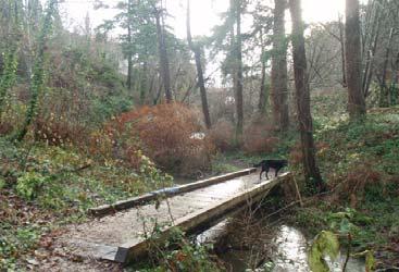
5 Appendix A: Park Improvement Plan Purpose & Objectives Purpose of this Project The objective of this project is to develop a plan to incorporate an expansion of Cecelia Ravine Park to serve the needs of the community, to offer engaging and inclusive experiences, and to complement and integrate with existing park features. In 2016, the City of Victoria purchased new properties to add 0.22 hectares (0.5 acres) to Cecelia Ravine Park. This new parkland was acquired using reserved funds from the disposition of the Ellice Street Playlot. The location of this parcel of land offers the opportunity to deliver expanded public spaces and amenities for the Burnside Gorge neighbourhood. In 2017, City of Victoria worked closely with the community to create a design for the new properties. The elements included in the design address key goals and guiding principles in City strategic documents as well as responding to community feedback from two phases of public engagement. This report outlines the project background, site conditions, public engagement process, and the final proposed design for this park improvement. Cecelia Ravine Park provides a safe and unique natural green space. The busy Galloping Goose Regional Trail corridor is a key public amenity adjacent to the west side of the park. People return to the park to enjoy its restored natural areas and to participate in active outdoor recreation. Others visit the park to meet their neighbours, tend garden plots and watch their children play with friends. There is a variety of activities and facilities that keep park visitors interested and engaged and encourage them to visit the park throughout the year. Vision for Cecelia Ravine Park (Cecelia Ravine Management Plan, 2011) Cecelia Ravine Park Improvement Plan 5

6 CITY OF VICTORIA 6
7 Store St Appendix A: Park Improvement Plan Project Background Neighbourhood Context Gorge Park Harriet Rd Irma St Gorge Rd Hospital Banfield Park Balfour Ave Gorge Rd Burnside Rd Rudd Park BGCC Point Ellice House Westside Village Washington Ave Neighbourhood Connectors Uptown Burnside School Bay St Jutland Rd Cecelia Rd Garbally Rd Bridge St Turner St Finlayson St Gorge Rd Mayfair Town Centre Douglas St Manchester St Dunedin St Topaz Ave Blanshard St Ellis St David St Hillside Ave Rock Bay Ave Government St Pembroke St Discovery St Topaz Park Kings Rd Downtown Burnside Gorge is a diverse neighbourhood unique in its mix of residential, commercial, and industrial areas. This neighbourhood is home to approximately 6,000 residents in 2,800 households. Most residents in the Burnside Gorge neighbourhood live within walking distance (400 metres) of at least one park, but the neighbourhood overall lacks a broad variety of easily accessible, quality green spaces. With 75% of housing units in multi-family buildings, access to a variety of open space and activities is essential. The block pattern in Burnside Gorge does not easily facilitate pedestrian access to the Galloping Goose, urban villages, and parks. The steepsided ravine of Cecelia Ravine Park separates a primarily residential neighbourhood to the east from the mixed use village areas to the west, making accessibility through, across and around this park an issue of key importance not only for park users, but also for the sustainable transportation goals of this neighbourhood. (See Fig. 1) Approved All Ages and Abilities Network All Ages and Abilities Candidate Destinations Planned neighbourhood connector at Cecelia Ravine Park (Cecelia Road entrance) Fig 1: Priority cycling routes through the Burnside Gorge neighbourhood (Burnside Gorge Neighbourhood Plan, Map 5) Cecelia Ravine Park Improvement Plan 7
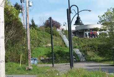
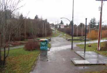
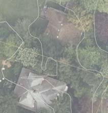
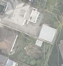
8 Land Acquisition In May 2009, the City entered into a long term lease agreement with BC Housing and the Victoria Cool Aid Society to enable the construction of the Rock Bay Landing shelter on Ellice Street Park in the Burnside Gorge neighbourhood. In response to the loss of this green space, Council authorized staff to pursue a no net loss of park space for this neighbourhood. A total of $2,000,000 for land acquisition and park development in this neighbourhood was approved by Council. In 2016, Council authorized staff to proceed with the purchase of 416 Cecelia, 3119 Washington and a portion of 3103 Washington, located adjacent to Cecelia Ravine Park for $950,000. The location of this parcel of land was considered strategically valuable from the perspective of parks and recreation in this neighbourhood. This quality green space is adjacent to the popular Galloping Goose Trail, close to the Burnside Gorge Community Centre, and offers an opportunity to deliver expanded public spaces and amenities for this community within Cecelia Ravine Park. Acquiring additional land adjacent to this park to expand the park boundary was also a recommendation of the Cecelia Ravine Management Plan. Cecelia Ravine Park: Existing Features At 3.85 hectares, Cecelia Ravine Park is the largest park in the Burnside Gorge Neighbourhood. The park offers a variety of leisure opportunities for surrounding residents, and also contains one of the largest natural areas in the City of Victoria park system. Cecelia Ravine Park has several key features which include steep sided ravines, woodland areas, open meadows, a creek, numerous secondary trails and stairs, a playground and a busy community centre. The Galloping Goose Regional Trail (GGRT) which is managed by the Capital Regional District (CRD) traverses through the park. The Burnside Gorge Community Centre opened in the park in 2007 and today offers a wide variety of programming and community support. In 2011, the City of Victoria approved the Cecelia Ravine Park Management Plan to guide continued investment in to the park. Since that time, the City has made ongoing investment into the park including the addition of a bike skills area, basketball court, a community garden, and ongoing work to restore the natural areas within the park. (See Fig. 2) Key park access points include: Galloping Goose Regional Trail (pedestrians/cyclists) Cecelia Road West (steep paved trail, pedestrians/cyclists) Stairs from Burnside Gorge Community Centre (pedestrians) Paved pathway off Napier Lane (pedestrians/cyclists) Gravel parking lot off Burnside Rd (vehicles/pedestrians/cyclists) CITY OF VICTORIA 8


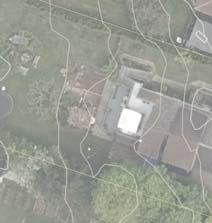
9 Appendix A: Park Improvement Plan Bike Skills Park Community Garden Burnside Gorge Community Centre Cecelia Ravine Park New Park Properties Location of new playground Existing Park Features 1 Outdoor Fitness Equipment 2 Existing Playground View from community centre stairs to Cecelia Road 3 Galloping Goose Regional Trail 4 Community Garden 5 Main Parking Lot 6 Bike Skills Park 7 Amphitheatre 8 Basketball Court 9 Cecelia Creek 10 Burnside Gorge Community Centre Fig 2: Cecelia Ravine Park existing amenities Cecelia Creek Cecelia Ravine Park Improvement Plan 9

 1 Existing condition of new properties 2 Existing condition of new properties 3 Existing Cecelia Road pathway connection Site Opportunities: Playground upgrade: The existing playground is 30 years")


10 Cecelia Ravine Park: New Properties The additional lands are 0.22 hectares (0.5 acres) and expand the total size of Cecelia Ravine Park to 4.07 hectares. The new property is predominantly flat and consists of an old driveway. There are a few small fruiting trees. The house that used to sit on the site was demolished after the city took possession of the property. There are several properties that do not currently have perimeter fencing. (See Fig. 3) 1 Existing condition of new properties 2 Existing condition of new properties 3 Existing Cecelia Road pathway connection Site Opportunities: Playground upgrade: The existing playground is 30 years old and has exceeded its service life. The new properties offer the opportunity to replace and modernize the play equipment, improve accessible play opportunities, include natural play elements, and provide high quality and creative play features. Improve health and wellness activities: Two outdoor fitness stations were installed in this park in 2014 to support the use of this park for circuit training and other fitness activities. The new properties provide the opportunity to expand the fitness area with new types of equipment and further strengthen the opportunity to use this space for fitness circuits. Improve site amenities: The new properties offer the opportunity to consider new types of site amenities within this park, including a public washroom, improved furnishings, bike parking, perimeter fencing, and pathway lighting. Improve accessibility: The new properties offer multiple opportunities to improve accessibility for the park and neighbourhood, including offering more accessible site amenities and improving site access. Upgrading the Cecelia Road pathway would remove a large accessibility barrier for this park, and also improve overall neighbourhood connectiveness. Site Challenges: Location of service utilities: There are a number of service utilities running along and across the ravine embankement that must be accommodated in an upgraded Cecelia Road pathway connection. 4 Existing playground and fitness equipment Pathway encroachment: Achieving a more accessible grade on the Cecelia Road pathway connection will require encroaching on land owned by Transport Canada and operated by the CRD. A right-of-way agreement with the CRD has been initiated. CITY OF VICTORIA 10

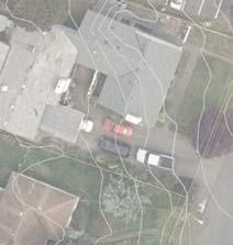
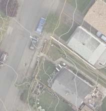
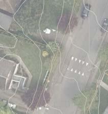
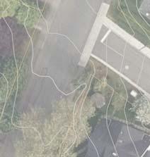
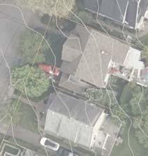
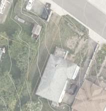
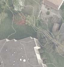
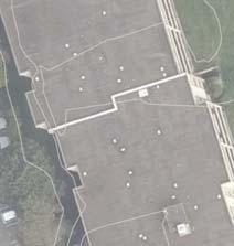
11 Appendix A: Park Improvement Plan WASHINGTON AVE 1 2 NEW PROPERTIES CECELIA RD Primary pedestrian/cyclist access from new properties to GGRT, Cecelia Ravine Park, Burnside Gorge Community Centre (steep, paved pathway) 4 3 GALLOPING GOOSE REGIONAL TRAIL Fig. 3: Existing Conditions of New Properties Cecelia Ravine Park Improvement Plan 11

12 CITY OF VICTORIA 12
13 Appendix A: Park Improvement Plan Design Process Guiding Documents In developing the preliminary materials for this project, staff reviewed a variety of guiding documents. The following is a summary of some of the guiding principles or objectives that have helped frame the proposed improvements to the new lots. Parks and Open Spaces Master Plan (2017) Identify opportunities to daylight or celebrate culverted streams (1.2.3); Identify opportunities to incorporate more support amenities such as washrooms, drinking fountains, lighting and food services at select parks (2.1.5); Incorporate a variety of spaces for socializing and group gathering into park spaces (2.2.2); Identify new health and fitness cluster locations where outdoor fitness amenities, walking areas, playgrounds, and sports amenities are located near each other (2.3.1); Establish a target for the provision of play spaces within an 800 meter walking distance of 99% of households (2.3.2); Establish and maintain standards of care to ensure safe, high quality and creative play features (2.3.3); and, Prioritize the development of active transportation linkages and infrastructure that connects residents and visitors to parks (2.6.4). Cecelia Ravine Park Improvement Plan 13
14 Burnside Gorge Neighbourhood Plan (2017) Improve the connection of Cecelia Ravine and Cecelia Road through pathway improvements (e.g. grade, signage and lighting) (Sections (d), ) Work to remove invasive species and to improve native habitats in the ravine. Continue restoration of the creek and watershed. In addition, opportunities to make the mouth of Cecelia Creek more fish-friendly should be explored (Sections (a), ) Enhance the park s function for events through improvements to the amphitheatre function, collaboration with the Burnside Gorge Community Association on programming, and consideration of a shelter, seating, or other features to support music performances, block parties, live theatre, or casual neighbourhood gathering (Sections (b), ) Urban Forest Master Plan (2013) Maximize community benefits from the urban forest in all neighbourhoods (Goal 4) The urban forest contributes significantly to the beautification and local character of the public realm The urban forest is part of the social fabric of the city, providing a safe place for festivals, smaller social gatherings and the enjoyment of nature Residents enjoy significant health and recreational benefits from the public urban forest Favour the planting of larger growing tree species wherever practical Expand and enhance the urban forest on public and private lands Cecelia Ravine Park Management Plan (2011) Consider acquisition of additional park lands to expand the park boundaries (Recommendation 5) Create new facilities and amenities to attract more destination users who visit for longer periods of time (Goal 3) Improve secondary trail safety with better intersections and connections to the Galloping Goose Regional Trail (Goal 4) Consider location of outdoor fitness equipment (Recommendations 14, 16) CITY OF VICTORIA 14
15 Appendix A: Park Improvement Plan Upgrade the playground at 400 Cecelia Road (Recommendation 17) Conduct trail improvements to connect 400 block of Cecelia to the Galloping Goose Regional Trail (Recommendation 20, Appendix 5) Public Engagement Process In development of the improvement plan, the City hosted two rounds of public engagement in The first round was to collect general feedback and ideas about improvements to Cecelia Ravine Park and the new lots. The second was to solicit input on a proposed draft plan that had been developed based on the input from the first round of engagement. The summary of all engagement is included as Appendix A of this design report. Phase One Public Engagement From July 20 August 20, 2017, the City hosted the first phase of public engagement to collect general feedback and ideas about improvements to Cecelia Ravine Park. Through a variety of mechanisms including an online survey and in-person events, the City heard feedback from over 200 residents including: Over 60 local residents attended an open house in Cecelia Ravine Park 122 residents completed the online survey 30 seniors, and over 100 parents and children attended events at the Burnside Gorge Community Centre during three pop up engagement stations 40 people stopped by the pop up engagement station at the Selkirk Waterfront. Building on the results of public engagement from neighbourhood planning and the Parks and Open Spaces Master Plan, residents were asked to provide feedback on proposed improvements including a renovated playground, community gathering space, small parking area, relocated outdoor fitness area, and a new perimeter fence. In addition, they were asked to prioritize potential new park activities, with the results from engagement from highest to lowest, an expanded fitness area, community garden, picnic area and an open, grassy area. Cecelia Ravine Park Improvement Plan 15
16 Common feedback received on the improvement plan included: Support for all proposed improvements, especially a bigger, better playground. Safety for visitors of all ages, including multiple access points, lighting and clear views. Playground should offer a combination of play structures and natural play areas. Climbing was the most requested type of play feature. Consider a public washroom at this location. An expanded fitness area, new community garden space, and open grassy areas for picnicking and informal recreation were all popular potential new amenities for this park space. Improvements are needed to make the Cecelia Road pathway connection more accessible. Residents were also asked to help prioritize the types of play equipment they would like to see in the park. In order of selected priority these included: Things to climb on A zipline A natural play area Water play Swings Slides Things that spin Phase 2 Public Engagement In conjunction with the guiding principles, site analysis and feedback received in Phase 1, staff prepared a proposed improvement plan for the park. During October 2017, the City hosted the second phase of public engagement to collect feedback on the proposed park improvement plan. In all, the City collected feedback during this phase from approximately 80 residents, through an online survey and an open house hosted at the Burnside Gorge Community Centre. Overall, feedback received indicated widespread support for the improvements included in this plan. Community feedback included: Strong support for natural play elements and water/creek CITY OF VICTORIA 16
17 Appendix A: Park Improvement Plan themed play elements Strong support for outdoor fitness equipment Improvements should feel safe for everyone with multiple access points, good lighting and clear sightlines Strong desire to complete the Cecelia Road right-of-way pathway as a priority Cecelia Ravine Park Improvement Plan 17

18 CITY OF VICTORIA 18
19 Appendix A: Park Improvement Plan Park Concept Plan The final proposed park concept plan is based on feedback recieved during the community consultation process, as well as key deliverables and objectives in City planning documents. An illustrative plan is shown in Fig. 4. The park concept plan includes the following key park components: Larger, more accessible, playground An improved outdoor fitness area A new parking lot for vehicles Enhanced furnishings including bike racks, shade structure, pathway lighting and seating Community gathering areas, picnic facilities and open green space New public washroom An upgraded, accessible pathway connecting the western area of the park to the Galloping Goose Regional Trail and eastern Cecelia Ravine Park Enhanced tree canopy coverage and native planting areas Cecelia Ravine Park Improvement Plan 19


20 WASHIN GTON AVE PEDESTRIAN PATHWAY TO WASHINGTON AVE Existing COMMUNITY GREEN Open grass area for picnicking and play PERIMETER FENCE (Shown with solid line) Chainlink fencing along perimeter as required PLAYGROUND Combination of play structures and natural play elements LOW STONE WALL WITH GATE Allows parking area to be locked at night PUBLIC WASHROOM Accessible single stall PARKING AREA Space for 4-5 cars OUTDOOR FITNESS With rubber surfacing and additional structures COMMUNITY PICNIC AREA Grass area, picnic tables, shade trellis NEW PATHWAY With seating R IL GALLOPING GOOSE REGIONAL TRA CECELIA RD PATHWAY IMPROVEMENT Max. grade 8%, with mid-slope rest area, lighting, and stair connection at Cecelia Road Fig 4: Park Concept Plan CITY OF VICTORIA 20


21 Appendix A: Park Improvement Plan Park Components Key Plan: Playground PLAYGROUND R IL AL TRA Playground A larger, more accessible playground with a mix of natural and structured play opportunities is envisioned. Drawing inspiration from the nearby Cecelia Creek, the play area includes creek-themed play opportunities, which may include elements such as creek-inspired imaginative play, or a play water channel and pump. Structured play will include climbing opportunities and accessible surfacing. Natural play opportunities and climbing were both high priorities from the public engagement. A zipline was also frequently requested, however a review of available space and siting requirements for play equipment determined this would not be feasible. Playground Examples Cecelia Ravine Park Improvement Plan 21


 were both")
22 Outdoor Fitness Equipment CECELIA RD OUTDOOR FITNESS EQUIPMENT Key Plan: Outdoor Fitness Equipment An expanded outdoor fitness area is located adjacent to the Cecelia Road pathway in order to allow for continued use of the ravine slopes and existing equipment within the park to continue as a fitness circuit. The area will include a wider range of equipment and rubber surfacing to complement the activities provided at the community centre. Rubber surfacing and a greater range of equipment (especially stationary equipment such as horizontal and parallel bars) were both requests that were recieved during public consultation. Outdoor Fitness Equipment Examples CITY OF VICTORIA 22


 was also important to the community.")
23 Appendix A: Park Improvement Plan Retained mature apple tree Key Plan: Community Amenities COMMUNITY GREEN R IL COMMUNITY PICNIC AREA OOSE REGIONAL TRA Community Amenities The concept plan includes a variety of community amenities including new internal pathways linking to Cecelia Road and the existing Washington Avenue connection; a community picnic area with a shade structure, new furnishings, an enhanced urban canopy and native planting areas, and an open grass area for community gathering and informal recreation. This new land provides the only opportunity within Cecelia Ravine Park for a flat lawn area for unstructured play. Providing opportunities for community gathering was an important consideration recieved from residents through public engagement for this project, and also through the Burnside Gorge Neighbourhood Planning process. Retaining an existing apple tree (near where the existing playground sits) was also important to the community. This tree is planned to be retained and will enhance the nearby picnic area. Example of seating elements Example of shade structure Example of community green Cecelia Ravine Park Improvement Plan 23


24 Parking CECELI A RD PARKING AREA GALLOPING GOOSE REGIONAL TRA Making use of the existing driveway, the concept plan includes a small parking area with space for 4-5 cars to serve the expanded park and to improve accessibility to the site. Bicycle parking facilities will also be provided on-site. Key Plan: Parking Example of parking area CITY OF VICTORIA 24


25 Appendix A: Park Improvement Plan Accessible Public Washroom PUBLIC WASHROOM Public feedback indicated that the City should consider including a public washroom adjacent to the improved playground site. The design of this facility would be contemplated during detailed design but would be a small built structure. Exterior walls could be animated with mural painting. Key Plan: Public Washroom Examples of public washrooms Cecelia Ravine Park Improvement Plan 25

.")

, making this pathway connection more accessible, and greatly")

26 CECELIA RD CECELIA ROAD PATHWAY GALLOPING GOOSE REGIO Cecelia Road Pathway The block pattern in Burnside Gorge does not easily facilitate pedestrian access to the Galloping Goose, urban villages and parks, making neighbourhood cohesion a key concern for residents of this neighbourhood. Key Plan: Cecelia Road Pathway A cycling and pedestrian connection through Cecelia Ravine Park connecting the western side of Cecelia Road to the Galloping Goose and the Burnside Gorge Community Centre was identified as a priority active transportation improvement for this neighbourhood through the Burnside Gorge Neighbourhood Plan (5.4.2). This connection is also identified as part of the City s Greenways Plan and the Cecelia Ravine Park Management Plan. The existing pathway at this location is steep, narrow and difficult to navigate for those with mobility challenges, on bicycles, or pushing strollers. The priority for this improvement was reiterated by the neighbourhood through public engagement for this project. The redesigned pathway included in this project will be wider and less steep (with a maximum grade of 8%), making this pathway connection more accessible, and greatly improving east-west active transportation connections through the Burnside-Gorge neighbourhood. Completion of a pathway that meets accessible grades will require agreement from the Capital Regional District as a portion of the pathway would fall outside lands owned by the City. Preliminary conversations with CRD staff indicate support for this approach as it would also help improve sightlines from the pathway onto the Galloping Goose Regional Trail. Existing pathway conditions (Top: from GGRT; Bottom: from Cecelia Rd.) CITY OF VICTORIA 26

27 Appendix A: Park Improvement Plan Cecelia Ravine Park Improvement Plan 27
28 Implementation Budget The City of Victoria has worked with an external costing consultant to prepare a preliminary (Class D) cost estimate for the proposed park improvements. The total anticipated construction budget for this project, including 10% design costs and 25% contingency, is $1,568,700. CLASS D (PRELIMINARY) COST ESTIMATE Park Hard and Soft Landscaping (paving, fencing, bollards, plantings, etc.) $167,000 Park Amenities (furnishings, playground/fitness equipment) $290,000 Lighting $70,000 Washroom (including servicing) $250,000 Cecelia Road Pathway $384,000 Construction Cost $1,162,000 Design Services (10%) $116,200 Construction contingency (25%) $290,500 TOTAL 2018 Estimated Costs $1,568,700 Timeline This project is being presented to Council for approval at the beginning of the detailed design phase. Construction is scheduled to start in the third quarter of 2018 and is anticipated to be completed by December CITY OF VICTORIA 28
29 CITY OF VICTORIA 30
Burnside Gorge Neighbourhood Plan. Engagement Summary
 Burnside Gorge Neighbourhood Plan Engagement Summary Table of Contents Engagement Summary... 3 Phase One Engagement (April May 2015)... 4 Phase Two Engagement (January March 2016)... 4 Appendix One: Summary
15. Rock Bay Employment Sub-Area
 15. Employment Sub-Area Future Land Use Directions and Urban Design The area will continue to serve as Victoria s urban industrial district. The waterfront is a key location for heavier, often harbour-dependent
Johnson Street Bridge Public Realm Update
 Johnson Street Bridge Public Realm Update August 20, 2015 Background Johnson Street Bridge Replacement Project impacts a diverse range of stakeholders In addition to a new bridge, the project also includes
South th E ast Communit ity Centre (SECC)
") South East Community Centre (SECC) 1 New Park Design & Community Centre Update Thursday, February 8, 2018 Public Open House Thank you for attending this Open House! The town and the Consulting Team will
South East Community Centre (SECC) 1 New Park Design & Community Centre Update Thursday, February 8, 2018 Public Open House Thank you for attending this Open House! The town and the Consulting Team will
4. Parks, Open Space and Waterways
 4. s, Open Space and Waterways Other Relevant Policies & Bylaws Official Community Plan s and Open Spaces Master Plan ways Plan Management and Improvement Plans Goals: 1. Protect and enhance Vic West s
Figure 3-1: Public Realm Plan
 3 Public Realm Figure 3-1: Public Realm Plan 3.1 Public Realm Concept The public realm concept for the Little Mountain site integrates a clear and accessible movement network with public spaces for social
SUMMARY OF PHASE ONE ENGAGEMENT BURNSIDE GORGE AND DOUGLAS AREA PLAN
 SUMMARY OF PHASE ONE ENGAGEMENT BURNSIDE GORGE AND DOUGLAS AREA PLAN OVERVIEW Throughout April, May and June the City of Victoria engaged with more than 1,000 people on the future of the Burnside neighbourhood.
8. Urban Villages. Other Relevant Policies & Bylaws Official Community Plan Development Permit Area Designations and Guidelines
 8. Urban Villages Urban villages provide walkable shops and services, encourage a neighbourhood social life, create a sense of place and provide different housing options. More housing near Urban Villages
4. Parks, Open Space and Urban Forest
 4. Parks, Open Space and Urban Forest Goals 1. Enhance parks as public gathering places for the neighbourhood 2. Refresh park facilities to attract diverse ages and activities 3. Improve waterfront access
1. Parks & Recreation Neighborhood Parks Community Parks Special Use Sites 2. Open Space 3. Trails
 Appendix A: Park Classifications The intent of parks and recreation classifications is to aid in making acquisition and design decisions for park sites, facilities and the organization of recreation space
section 3: Vision, Values and Goals
 Vision, Values and Goals 3 2041 Vision: Victoria is an urban sustainability leader inspiring innovation, pride and progress towards greater ecological integrity, livability, economic vitality, and community
Long Branch-Wayne Local Park Renovation Project
 Montgomery Parks Long Branch-Wayne Local Park Renovation Project Community Meeting #2 September 20, 2016 Oak View Elementary School 7:00-9:00 PM Welcome / Team Introductions M-NCPPC (Montgomery Parks)
Planning Board Briefing
 Planning Board Briefing Why Now? The Sector Plan Implementation Chapter States: Before Stage 1 begins, the following must occur: Approval of the Sectional Map Amendment. Approval of the Greater Lyttonsville
Project purpose. advise. The purpose of the Beaumaris Lake Open Space Rehabilitation project is to: + Develop a Functional Program Concept
 Project purpose owns Road Beaumaris Road The purpose of the Beaumaris Lake Open Space Rehabilitation project is to: + Develop a Functional Program Concept + Guide Rehabilitation of Landscape and Community
SECTION ONE: INTRODUCTION. introduction
 introduction 1 INTRODUCTION Since it was first established in 1843 as a trading post for the Hudson s Bay Company, Victoria has evolved into a Provincial capital city that is recognized across Canada and
10.0 Open Space and Public Realm
 10.0 Open Space and Public Realm 10.0 Open Space and Public Realm The Public Open Space System is comprised of: outdoor spaces available for public use that are either publicly owned (e.g., parks and
North Oakville East Parks Facilities Distribution Plan. November, 2009
 North Oakville East November, 2009 POLICY CONTEXT 1) Purpose a) The purpose of this document is to be a guide for the location, configuration, design and development of the parks system for the North Oakville
Shared Principles and Emerging Plan Directions
 Shared Principles and Emerging Plan Directions Introduction Since the Fairfield Neighbourhood planning process launched in June 2016, we have heard from many residents, businesses, groups and other people
The Recreational Heart of Cannington - MacLeod & Claire Hardy Parks
 The Site Claire Hardy Park and MacLeod Park are both located within the community of Cannington on opposing shorelines of the Beaver River and are accessible to each other by a footbridge spanning the
PUBLIC RIGHT-OF-WAY IN THIS CHAPTER PUBLIC REALM
 PUBLIC RIGHT-OF-WAY This section provides design guidelines for improvements in the public right-of-way. The public right-of-way refers to streets, sidewalks, non-vehicular thoroughfares, parks and greenways
The Vision. Photo provided by The Minervini Group. 46 Vision, Objectives & Strategies
 Vision, Objectives & Strategies The is the public framework and guide for future development of the Grand Traverse Commons. The establishes public polices for infrastructure, the preservation of natural
APPENDIX D: PARKS AND RECREATION ACTION PLAN
 APPENDIX D: PARKS AND RECREATION ACTION PLAN Goals The following goals are specific to the development, maintenance, and operation of the existing parks in the Township, as well as the acquisition and
Key Moves in the Plan
 Key Moves in the Plan 2 Add housing that fits the neighbourhood s character Make it easier to leave the car behind Oak Bay Avenue Village plan to be completed in future planning process Future active transportation
RECREATION AND OPEN SPACE ELEMENT GOALS, OBJECTIVES, AND POLICIES
 RECREATION AND OPEN SPACE ELEMENT GOALS, OBJECTIVES, AND POLICIES Goal 7 To provide park facilities, recreation programs, and open space resources that are safe, adequate, and accessible to all City residents,
Errol Heights Park and Community Garden Frequently Asked Questions March 22, 2018
 Errol Heights Park and Community Garden Frequently Asked Questions March 22, 2018 Question 1: What improvements are planned for Errol Heights Park? How will the community be engaged in the process to shape
POLICY The Trillium Park Master Plan was approved by the Board on April 4, 2012.
 TO: FROM: SUBJECT: Date: June 2, 2014 Board Members Vancouver Park Board General Manager Parks and Recreation Proposed Trillium North Park Artists Garden RECOMMENDATION THAT the Board approve the new arts-focused
Plan Framework Report. Attachment A
 Plan Framework Report Attachment A Uptown-Douglas Corridor Plan - Plan Framework Report Contents Introduction... 1 Planning Process... 3 Project Objectives... 4 Vision... 5 Community Values... 6 Structural
Comprehensive Plan ADOPTED APRIL 2014
 Comprehensive Plan ADOPTED APRIL 2014 8 8. Outstanding Recreational & Cultural Opportunities We are proud of our community s parks and recreation system. Our community will ensure that the legacy of our
Animating the Rideau Canal December 2013
 Executive Summary Animating the Rideau Canal December 2013 Why study the Rideau Canal? The Rideau Canal has been an important part of Ottawa throughout its history, and has shaped and been shaped by the
Appendix 4 Park, Trail, and Recreation Facilities For more information, call the Park Planning and Stewardship Division at
 Appendix 4 Park, Trail, and Recreation Facilities For more information, call the Park Planning and Stewardship Division at 301-650-4380 montgomery county planning board maryland-national capital park and
John M. Fleming Managing Director, Planning and City Planner. Old East Village Dundas Street Corridor Secondary Plan Draft Terms of Reference
 Report to Planning and Environment Committee To: From: Subject: Chair and Members Planning & Environment Committee John M. Fleming Managing Director, Planning and City Planner Old East Village Dundas Street
North Adelaide Playspace and Pocket Orchard
 The Adelaide City Council invites engagement from the community about Playspace and Pocket Orchard Project Summary Adelaide City Council invites feedback from the community on the Tidlangga (Park 9) Playspace
QUESTION 8: What are your Public Realm priorities for implementation? What would you like to see happen first? TELL US WHAT YOU THINK
 Public Realm Plan How will the Public Realm Plan be implemented? The Public Realm Plan document will set out a vision for the next 30 years. Over time, Plan elements and aspects can be implemented as opportunities
Appendix H: Easement cross sections
 Appendix H: Easement cross sections SHARED PATH 1.5m FOOTPATH NATURE STRIP 7.3m CARRIAGEWAY 2.7m NATURE STRIP EXISTING PIPELINE 150mm DIA 5.0m (approx.) LOCAL ACCESS ROAD EXISTING PIPELINE 500mm DIA 2.7m
100 Dix Drive Conceptual Master Plan. Wyatt Thompson, PLA, ASLA, Assistant Director Lindsay Stucki, Intern Park Planner
 100 Dix Drive Conceptual Master Plan Wyatt Thompson, PLA, ASLA, Assistant Director Lindsay Stucki, Intern Park Planner Final Draft Prepared August 2018 Introduction On September 20, 2016, the City of Manhattan
Parks Renaissance. Strategy. Director, Operations. General Committee. Presentation to. May 16, Barb Rabicki
 1 Parks Renaissance Strategy Presentation to General Committee May 16, 2016 Barb Rabicki Director, Operations Incorporates recommendation to complete Parks Renaissance Strategy Feedback / requests from
More than 30 adults and 19 children were involved in these community workshops.
 Linwood Workshops held at Household of Faith Deliverance Church 3.29.08 and 4.05.08 What is a Design Workshop? We use the term workshop (often called charrette among design professionals) to describe a
Town Centre Park. Delahaye. David Avenue. Pine wood. Pipeline Rd. Pinetree. Town Ctr Blvd. Guildford. Guildford. High St. Westwood. Pinetree.
 WELCOME This open house is to give you an opportunity to review the proposed design of an outdoor performance and events plaza at Town Centre ark and to share your ideas, suggestions and thoughts related
Queensborough Eastern Neighbourhood Node. Community Open House
 Queensborough Eastern Community Open House The Vision The Queensborough Eastern will become the heart of eastern Queensborough. Through a sensitive mix of viable commercial and residential areas, the neighbourhood
master plan hodge park
 KCMO Parks & Commissioners Recreation Board of Parks & Recreation Kansas City, Missouri Mark McHenry Director Heather Runkel Project Manager LAND3 Studio L.L.C. Bob G Bushyhead Principle Michael H Malyn
City Council March 27, Parks, Recreation, and Trails Master Plan
 City Council March 27, 2018 Parks, Recreation, and Trails Master Plan Planning Process Develop Goals and Objectives Inventory of Areas and Facilities Needs Assessment And Identification Public Participation
Mark-up of the effect of the proposed Bronte Village Growth Area OPA No.18 on the text of section 24, Bronte Village, of the Livable Oakville Plan
 Mark-up of the effect of the proposed Bronte Village Growth Area OPA No.18 on the text of section 24, Bronte Village, of the Livable Oakville Plan Notes: This document is provided for information purposes
38 Queen s University Campus Master Plan Part 1
 38 Queen s University Campus Master Plan Part 1 46 The Campus at the City Scale Chapter 4 The Campus at the City Scale 39 Queen s is an urban University centrally located in Kingston. Decisions made by
General Manager, Planning and Development; General Manager, Parks, Recreation and Culture. Proposed Mini-Park and Plaza Designations
 Corporate NO: R106 Report COUNCIL DATE: June 16, 2008 REGULAR COUNCIL TO: Mayor & Council DATE: June 12, 2008 FROM: SUBJECT: General Manager, Planning and Development; General Manager, Parks, Recreation
Corridor Vision. 1Pursue Minnehaha-Hiawatha Community Works Project. Mission of Hennepin County Community Works Program
 1Pursue Minnehaha-Hiawatha Community Works Project Minnehaha-Hiawatha Community Works is a project within the Hennepin Community Works (HCW) program. The mission of the HCW program is to enhance how the
Parks Master Plan Implementation: Phase I Waterfront Use and Design REPORT #: September 7, 2016 File #
 0 'O DI Lan-171-14 1 - THE CORPORATION OF THE TOWN OF COBOURG..,. STAFF REPORT TO: FROM: Mayor and Members of Council Dean A. Hustwick, Director of Recreation and Culture DATE OF MEETING: Committee of
Reimagining Arnolds Creek. Community engagement report. May 2018
 Reimagining Arnolds Creek Community engagement report May 2018 Melbourne Water is owned by the Victorian Government. We manage Melbourne s water supply catchments, remove and treat most of Melbourne s
Philip A. Ginsburg, General Manager Toks Ajike, Acting Planning and Capital Program Director
 Date: March 7, 2018 To: Through: From: Subject: Recreation and Park Commission Capital Committee Philip A. Ginsburg, General Manager Toks Ajike, Acting Planning and Capital Program Director Dan Mauer,
Washington Park Diagonal
 Public Input Meeting August 3, 2011 Nicole Stahly RLA DPR Project Manager Jesse Clark RLA, LEED Stream Design Paul Thomas RLA Stream Design Kerry White RLA Urban Play Studio Tonight s Agenda 1st Meeting:
Town Centre Park Master Plan Update - Terms of Reference
 CoQuitlam For Committee Our File: 12-6100-20/14-001/1 Doc#: 2176441.V7 To: From: Subject: For: City Manager General Manager Parks, Recreation & Culture Services Town Centre Park Master Plan Update - Terms
BISCUIT RUN PARK MASTER PLAN
 BOARD OF SUPERVISORS November 14, 2018 BISCUIT RUN PARK MASTER PLAN COUNTY OF ALBEMARLE ANHOLD ASSOCIATES Contents Project Introduction Property Background County Park Planning Process Existing Site &
planning toronto s downtown Parks and Public Realm Plan Request for Proposals Information Meeting Andrew Farncombe, Project Manager August 19, 2015
 planning toronto s downtown Parks and Public Realm Plan Request for Proposals Information Meeting Andrew Farncombe, Project Manager August 19, 2015 BATHURST ST Keeping Downtown a great place to live, work,
Blood Alley Square/Trounce Alley Redesign
 June 216 Kick-Off Events Questionnaire and Engagement Summary Background The City of Vancouver is redesigning Blood Alley Square and Trounce Alley, important public spaces in the heart of Gastown, which
3. VISION AND GOALS. Vision Statement. Goals, Objectives and Policies
 Vision Statement Queen Creek s interconnected network of parks, trails, open spaces and recreation opportunities provide safe and diverse activities and programs that sustain its unique, small town, equestrian
New Park / Entry Court & Plaza Concept Design
 New Park / Entry Court & Plaza Concept Design The SECC Public realm is proposed to have a focus on health, wellness, and community and that site users will include patrons of the neighbourhood. The block
RECREATION, OPEN SPACE AND GREENWAYS ELEMENT GOALS, OBJECTIVES, AND POLICIES
 RECREATION, OPEN SPACE AND GREENWAYS ELEMENT GOALS, OBJECTIVES, AND POLICIES GOAL R-1: DEVELOP A RECREATION, OPEN SPACE AND GREENWAYS SYSTEM AS AN INTEGRAL COMPONENT OF AN OVERALL, COUNTY-WIDE ECONOMIC
PARK AND RECREATION MASTER PLAN UPDATE
 PARK AND RECREATION MASTER PLAN UPDATE 2014-2018 Prepared for: Avon Parks, Recreation and Beautification Council (PRBC) and Town of Avon Prepared by: Lehman & Lehman, Inc. 24-Apr-14 Mission Statement The
MASTERPLAN AND PARK IMPROVEMENTS
 ST.JAMES PARK MASTERPLAN AND PARK IMPROVEMENTS Stakeholder Meeting 3 April 26, 2016 Team: PMA Landscape Architects Ltd. Lead Landscape Architects MASS LBP Public Facilitation Consultant RAW Design Architectural
ATTACHMENT A AERIAL PHOTO OF McINTIRE PARK EAST
 ATTACHMENT A AERIAL PHOTO OF McINTIRE PARK EAST McIntire Botanical Garden Request for Proposals Attachments Page 1 of 33 ATTACHMENT B - MEMORANDUM OF AGREEMENT WITH THE CITY OF CHARLOTTESVILLE McIntire
REPORT SPECIAL COUNCIL MEETING MEETING DATE: MAY 2, Five Year Review of the 2012 Parks, Recreation and Library Facilities Master Plan
 REPORT SPECIAL COUNCIL MEETING MEETING DATE: MAY 2, 2017 FROM: Recreation and Culture Department DATE: April 25, 2017 SUBJECT: Five Year Review of the 2012 Parks, Recreation and Library Facilities Master
Open Space and Recreational Resources
 Chapter 3: Open Space and Recreational Resources A. INTRODUCTION Under the 2012 City Environmental Quality Review (CEQR) Technical Manual guidelines, open space is defined as publicly accessible, publicly
AVONDALE ESTATES GREENSPACE AD-HOC COMMITTEE
 AVONDALE ESTATES GREENSPACE AD-HOC COMMITTEE INVENTORY AND RECOMMENDATIONS REPORT November 7, 2018 Our Mission Statement: To provide assistance and support, through professional expertise in matters of
DOWNTOWN GEORGETOWN PLANNING STUDY
 DOWNTOWN GEORGETOWN PLANNING STUDY Community Workshop #3 Thursday, May 4, 08 The Planning Partnership OVERVIEW OF STUDY, PROCESS & MILESTONES We are here PURPOSE OF THE STUDY To develop a clear vision
URBAN DESIGN BRIEF. 2136&2148 Trafalgar Road. Town of Oakville
 URBAN DESIGN BRIEF 2136&2148 Trafalgar Road Town of Oakville Prepared By: METROPOLITAN CONSULTING INC For 2500674 Ontario Inc November 2016 TABLE OF CONTENTS Page No. 1.0 Introduction/Description of Subject
Keyport. Vision for Keyport
 Keyport Vision for Keyport Keyport is a rural, historic waterfront village bounded and limited in size by its natural borders of water and the Naval Undersea Warfare Center. The community consists primarily
Throughout. square. (Crystal City Vision Plan 2050)
") 1: Terms related to the PSMP document 1 public space (see also public realm, civic space) An open space designated on the regulating plan, accessible to all, including Plazas, Mini Parks, and Neighborhoods
1: Terms related to the PSMP document 1 public space (see also public realm, civic space) An open space designated on the regulating plan, accessible to all, including Plazas, Mini Parks, and Neighborhoods
DOWNTOWN PARKS & PUBLIC REALM PLAN
 DOWNTOWN PARKS & PUBLIC REALM PLAN CHALLENGES The Parks and Public Realm Strategy addresses challenges associated with a growing Downtown, including: GOALS 3.3 New buildings will fit within their existing
IMAGINE CLEARWATER. Community Workshop 3. November 2016
 IMAGINE CLEARWATER Community Workshop 3 November 2016 Imagine Clearwater has been a 6-month community-focused process to re-envision the downtown waterfront. VISIONING FRAMEWORK MASTER PLAN HOW CAN WE
PLAN ELEMENTS WORKSHOP. April 5, 2016
 PLAN ELEMENTS WORKSHOP April 5, 2016 needs more housing. But there is no one-size fits-all solution. Every neighborhood has its own character. In some places, density is not only appropriate it is badly
Bow to Bluff Public Realm Plan Design Update
 Bow to Bluff Public Realm Plan Design Update December 017 Great public spaces encourage people to gather, recreate, explore and discover. Introduction The City of Calgary is planning to improve the corridor
Mendota Heights 2040 Comprehensive Plan Draft Vers
 4 Parks and Trails The City of Mendota Heights boasts a variety of recreational and open space opportunities. Few cities can claim access to regional trails, riverside and lakeside parks, scenic bluffs
Workshop 3. City of Burlington Waterfront Hotel Planning Study. September 14, The Planning Partnership
 Workshop 3 City of Burlington Waterfront Hotel Planning Study September 14, 2017 The Planning Partnership The Waterfront Hotel Planning Study 01 The Brant & Lakeshore Planning Study will establish a Strategic
Welcome. Community Consultation Meeting November 28, Review and discuss the Bathurst Quay Neighbourhood Plan Framework
 Welcome Community Consultation Meeting November 28, 2016 Why Are We Here Today? Review and discuss the Bathurst Quay Neighbourhood Plan Framework Review and discuss an Action Plan for Implementation Next
The following principles guide the development of goals and strategies to protect and promote these amenities:
 OPEN SPACE/PARKS/TRAILS/RECREATION GOALS/STRATEGIES Cherry Hills Village is a living environment that offers low density development, open areas, public scenic vistas, public trails and public parks. This
Design Alternatives Workshop. Hilfiker Park Master Plan Workshop #2
 Design Alternatives Workshop Hilfiker Park Master Plan Workshop #2 Agenda for Tonight Staff Presentation (40 min) Introduction Master Plan Process Planning Context What We ve Heard So Far Design Alternatives
Waverley West B Secondary Planning Process. Open House South Pointe School April 25, 2018
 averley est B Secondary Planning Process South Pointe School April 25, 2018 averley est B Secondary planning process open house Please review the boards and provide your feedback. 1 The Role of a Secondary
ADOPTED CAPITAL IMPROVEMENT PROGRAM BUDGET ARROYO PROJECTS
 ADOPTED CAPITAL IMPROVEMENT PROGRAM BUDGET ARROYO PROJECTS HAHAMONGNA FY 212-216 Capital Improvement Program Priority Description Total Estimated Costs Appropriated Through FY 211 Adopted FY 212 FY 213
Vision Plan Kickoff Meeting Summary Report
 Vision Plan Kickoff Meeting Summary Report October 2018 The Vision Plan With the redevelopment of the Amtrak Property, Penn Station Partners (PSP) seeks to build on the creative talent and entrepreneurial
This Review Is Divided Into Two Phases:
 Semiahmoo Town Centre Review The purpose of this review: To review the Semiahmoo Town Centre Concept Plan, originally approved in 1993, to ensure that this centre will continue to serve the needs of South
4 C OMMUNITY D ISTRICTS
 4 C OMMUNITY D ISTRICTS N ew development in the Area will include many different types of land uses, including a destination retail area that attracts people from all over the region; recreation opportunities
East Bayshore Road Neighbourhood
 East Bayshore Road Neighbourhood Northridge Property Management Urban Design Brief 3195 East Bayshore Road City of Owen Sound January 2016 East Bayshore Road Neighbourhood Northridge Property Management
Citizen s Advisory Committee
 Citizen s Advisory Committee 13 Members 6 Meetings (5 Locations) 1 Public Meeting Numerous Report Drafts Countless Hours of Review Immeasurable Input Special Thank You To: Jack Cohen Brian Kile George
Welcome! HORSESHOE BAY PARK. Welcome!
 Welcome! HORSESHOE BAY PARK Welcome! Where are we in the process? Today we would like your input on how Horseshoe Bay Park can be upgraded to serve the community s needs better. CONSULT STAKEHOLDERS TAKE
Chapter 6. Overall Vision RECOMMENDATIONS. More Trail and Trail. Connections. Equal Access to Park. Facilities and Programs. Water Access.
 Overall Vision More Trail and Trail Connections Equal Access to Park Facilities and Programs Water Access Environment Variety Chapter 6 RECOMMENDATIONS Chapter 6 The following recommendations for park,
Las Colonias Park Master Plan
 2013 Las Colonias Park Master Plan City of Grand Junction June 2013 Introduction Las Colonias Park, a 101 acre parcel on the edge of the Colorado River south of downtown, was deeded to the City of Grand
Building Great Neighbourhoods. Strathcona
 Building Great Neighbourhoods Strathcona March 21, 2018 Becky Redford Project Manager, Planning & Design Building Great Neighbourhoods Integrated Infrastructure Services Welcome and Purpose To provide
Moody Centre Station TOD Area Today
 Moody Centre Station TOD Area Today WHAT IS a transit-oriented Murray Street development area? A Transit-Oriented Development (TOD) Area is a dense, walkable residential and commercial area built to support
BENJAMIN BANNEKER PARK FRAMEWORK PLAN (PLAN ADOPTION)
") BENJAMIN BANNEKER PARK FRAMEWORK PLAN (PLAN ADOPTION) COUNTY BOARD MEETING DECEMBER 16, 2017 County Board Consideration: Adopt the Benjamin Banneker Park Framework Plan and Design Guidelines Framework
BENJAMIN BANNEKER PARK FRAMEWORK PLAN (PLAN ADOPTION) COUNTY BOARD MEETING DECEMBER 16, 2017 County Board Consideration: Adopt the Benjamin Banneker Park Framework Plan and Design Guidelines Framework
Charles P. Johnson and Associates. Annapolis Landscape Architects
 Charles P. Johnson and Associates Annapolis Landscape Architects AGENDA Introduction Project Limits and Scope Site Analysis Opportunities & Constraints Program Goals Image Boards Design Alternatives Pros
The Illinois Department of Transportation and Lake County Division of Transportation. Route 173, including the Millburn Bypass
 The Illinois Department of Transportation and Lake County Division of Transportation welcome you to this Public Hearing for U.S. Route 45 from Illinois Route 132 to Illinois Route 173, including the Millburn
2. reimagine kings way undercroft as a community space
 2. reimagine kings way undercroft as a community space CLARENDON STREET CLARKE STREET QUEENS BRIDGE STREET MORAY STREET CITY ROAD BALSTON STREET BOYD KINGS WAY POWER STREET KAVANAGH WEST GATE FREEWAY Figure
ANCHORAGE PARK REPORT CARD Assessing A Park s Appearance, Function, & Condition
 ANCHORAGE PARK REPORT CARD Assessing A Park s Appearance, Function, & Condition Park Name: Is Your Park an A or an F? Your Name: Contact Information Optional: Date: General Instructions: Phone: Email:
Design Considerations
 Essential to the development of a successful Master Plan for the Park Complex is input from the community that the park will serve. The community outreach component of the planning process included numerous
CITY OF GAINESVILLE PARKS, RECREATION AND CULTURAL AFFAIRS DEPARTMENT VISION 2020
 CITY OF GAINESVILLE PARKS, RECREATION AND CULTURAL AFFAIRS DEPARTMENT VISION 2020 A BLUE PRINT FOR THE NEXT 20 YEARS The PRCA Vision 2020 Master Plan, adopted in November 2012, addresses the current state
PROPOSED REDEVELOPMENT OF THE GLEN ABBEY GOLF CLUB. STREETSCAPE DESIGN STUDY (excerpt from the Urban Design Brief) TOWN OF OAKVILLE.
 TOWN OF OAKVILLE.") PROPOSED REDEVELOPMENT OF THE GLEN ABBEY GOLF CLUB STREETSCAPE DESIGN STUDY (excerpt from the Urban Design Brief) TOWN OF OAKVILLE OCTOBER, 2016 for 2.4.2 STREETS Streets are the single largest component
PROPOSED REDEVELOPMENT OF THE GLEN ABBEY GOLF CLUB STREETSCAPE DESIGN STUDY (excerpt from the Urban Design Brief) TOWN OF OAKVILLE OCTOBER, 2016 for 2.4.2 STREETS Streets are the single largest component
[PLANNING RATIONALE] For Site Plan Control and Lifting of Holding Zone By-Law 101 Champagne Avenue. May 23, 2014
![[PLANNING RATIONALE] For Site Plan Control and Lifting of Holding Zone By-Law 101 Champagne Avenue. May 23, 2014](/thumbs/75/71599615.jpg "[PLANNING RATIONALE] For Site Plan Control and Lifting of Holding Zone By-Law 101 Champagne Avenue. May 23, 2014") [PLANNING RATIONALE] For Site Plan Control and Lifting of Holding Zone By-Law 101 Champagne Avenue May 23, 2014 Contents 1.0 Introduction... 2 2.0 Site Context... 2 2.1 Adjacent Uses... 2 Figure 1: Site
[PLANNING RATIONALE] For Site Plan Control and Lifting of Holding Zone By-Law 101 Champagne Avenue May 23, 2014 Contents 1.0 Introduction... 2 2.0 Site Context... 2 2.1 Adjacent Uses... 2 Figure 1: Site
Potential Green Infrastructure Strategies May 6, 2015 Workshop
 Potential Green Infrastructure Strategies May 6, 2015 Workshop Background The City of Cortland is developing the Tioughnioga Urban Headwaters Green Infrastructure Action Plan with funding from the National
The transportation system in a community is an
 7 TRANSPORTATION The transportation system in a community is an important factor contributing to the quality of life of the residents. Without a sound transportation system to bring both goods and patrons
City of Plattsburgh DRI: Downtown Streetscapes & Riverfront Access. Downtown Streetscape and Riverfront Access Design
 City of Plattsburgh DRI: Downtown Streetscapes & Riverfront Access Welcome Thank you for coming this evening. Agenda PART I - Project Context The Downtown Revitalization Program Our DRI Projects Other
South Bend Park. Visioning Plan
 South Bend Park Visioning Plan 2007 South Bend Park, Visioning Program, Executive Summary The South Bend Park Visioning Program began with the receipt of an application from the Friends of South Bend Park,