1 Metrolinx overview. Mission We connect our communities. Vision Getting you there better, faster and easier
|
|
|
- Emory Shawn Shaw
- 5 years ago
- Views:
Transcription
1 Mission We connect our communities Vision Getting you there better, faster and easier Values Play as a team Think forward Serve with passion 1 Metrolinx overview


2 go transit, up express, presto Serve a population of more than seven million across more than 11,000 square km stretching from Hamilton and Kitchener-Waterloo in the west to Newcastle and Peterborough in the east, and from Orangeville and Beaverton in the north to Niagara Falls in the south. In operation since 1967, GO now carries more than 70 million passengers a year. The PRESTO card is the smart card fare payment system seamlessly connecting 11 transit agencies across the GTHA and Ottawa. PRESTO replaces the need for tickets, tokens, passes or cash. UP Express connects the country's two busiest transportation hubs: Toronto Pearson International Airport and Union Station in downtown Toronto, offering a 25-minute journey from end to end, with trains departing every 15 minutes. Metrolinx Overview 2

3 Regional transit map connecting the region 3 Metrolinx overview

4 Regional Transportation Plan Metrolinx published the first regional transportation plan (RTP) for the Greater Toronto and Hamilton Area (GTHA) in We are required to review the RTP at least every ten years, in alignment with Ontario s Growth Plan for the Greater Golden Horseshoe. The legislative review of initial RTP led to the development of the 2041 RTP. Key outcomes include: o Quadrupling the number of people and doubling the number of jobs within walking distance of Frequent Rapid Transit o 27x more kilometres of the Frequent Rapid Transit o In addition to the capital costs, successful implementation will also require operating funding for transit services, fare integration and programs for walking and cycling Vision: The GTHA will have a sustainable transportation system that is aligned with land use, and supports healthy and complete communities. The system will provide safe, convenient and reliable connections, and support a high quality of life, a prosperous and competitive economy, and a protected environment. 31 Priority Actions to Support the 5 Strategies Metrolinx Overview 4


5 The objective of the Community Benefits Program is that people from historically disadvantaged communities and equity-seeking groups are positively impacted by the Eglinton Crosstown. Program has three streams: 1. Employment, Training and Workforce Development 2. Social Enterprises and Social Procurement 3. Investment (Community Improvements) Community Benefits 5 Metrolinx overview

6 6 Metrolinx overview Community Benefits


7 Business support shop local campaign 7 Metrolinx overview

8 8 Metrolinx overview Parking


 Crosstown East Office")
9 Stay in Touch or hours/7days a week crosstown@metrolinx.com facebook.com/thecrosstown twitter.com/crosstownto instagram.com/eglinton_crosstown Crosstown West Office 1848 Eglinton Ave W (at Dufferin) Crosstown East Office 660 Eglinton Ave E (at Bayview) METROLINX OVERVIEW 9

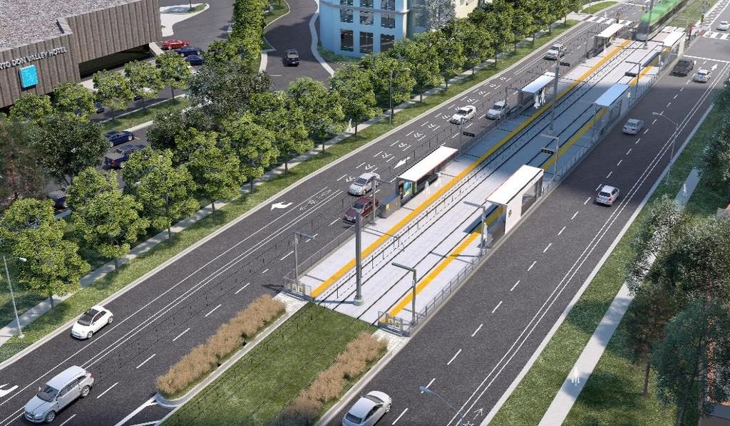
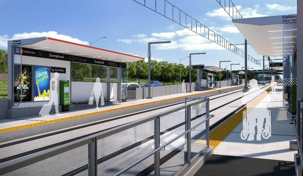
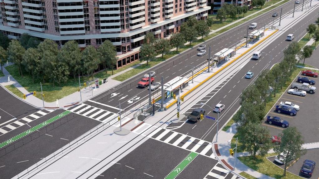
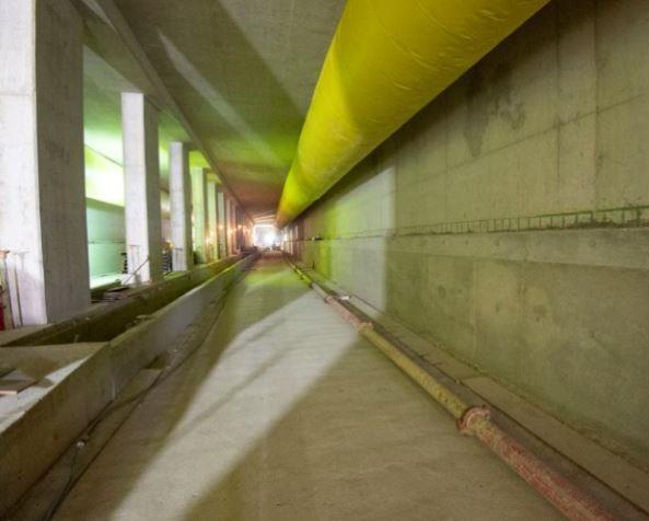
10 Project Overview 19 km route separated from regular traffic 10-kilometres underground; 9-kilometres at surface east of Laird 15 underground stations and 10 surface stops 20,000 m 2 maintenance and storage facility to maintain and house 76 vehicles Transit communications system Links to 54 bus routes, 3 subway stations, GO Transit, UP Express station

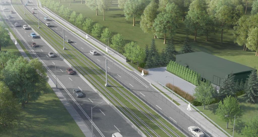
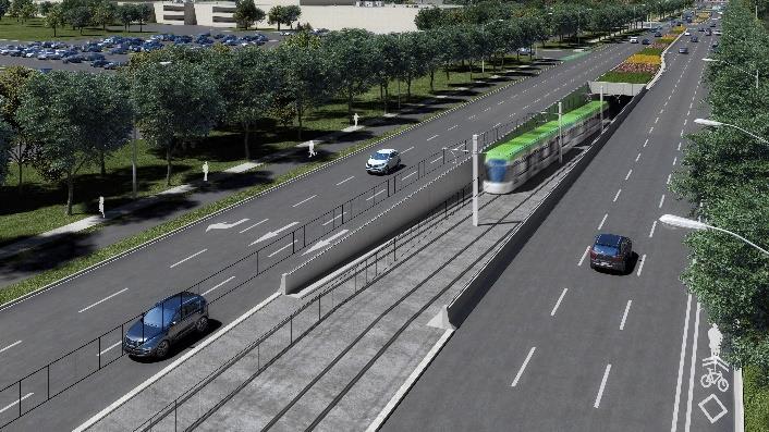
11 At-Grade Alignment


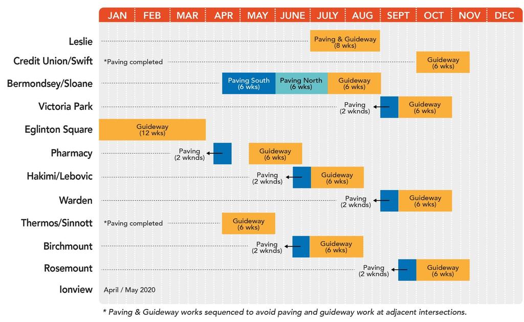
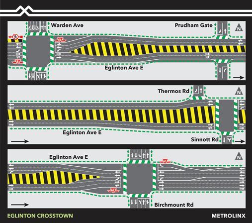
12 Eglinton Avenue East - At-Grade Construction Major work will be occurring at intersection between Leslie Street and Ionview Road throughout 2019 LRT guideway will be constructed in the middle of Eglinton and track will be installed The work takes place in two stages paving, followed by guideway construction and track installation
13 CTS requires temporary changes to intersections operations from Credit Union to Ionview for road paving: Eglinton must be widened for LRT; road must be paved prior to guideway installation Traffic restrictions required for two weekends one weekend no northbound access to Eglinton; one weekend no southbound access to Eglinton Because of the concrete road base at Credit Union/Swift and Bermondsey/Sloane restrictions longer; six weeks no northbound access to Eglinton; six weeks no southbound access to Eglinton Restrictions are not full intersection closures. Eglinton remains open in both directions at all times Work will not take place at adjacent intersections Emergency services access maintained 13


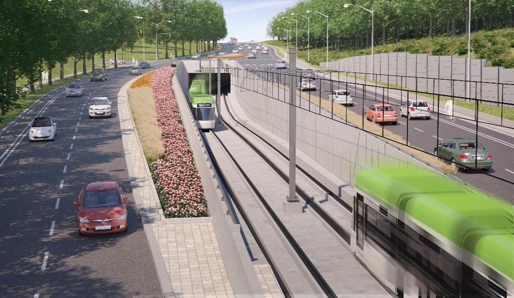
14 Sloane/Bermondsey (6 weeks per side) Victoria Park to Ionview (One weekend per side) 14
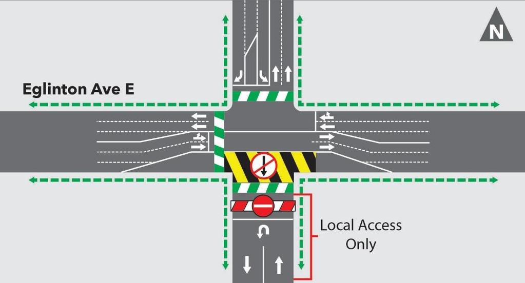
15 CTS requires temporary changes to intersections operations from Credit Union to Ionview for guideway construction: Guideway work in centre of intersection; no through north/south traffic for six weeks; includes rail installation Rail installation will be completed during the six weeks Signal timing will be optimized at the main and adjacent intersections to benefit operations Restrictions are not full intersection closures. Eglinton remains open in both directions at all times Work will not take place at adjacent intersections North and south traffic can access Eglinton at all times via right turns Eglinton traffic can make right turns to access north and south streets Emergency services access maintained 15


16 No through north/south traffic and no left turns for six weeks to construct guideway and install rail. 16
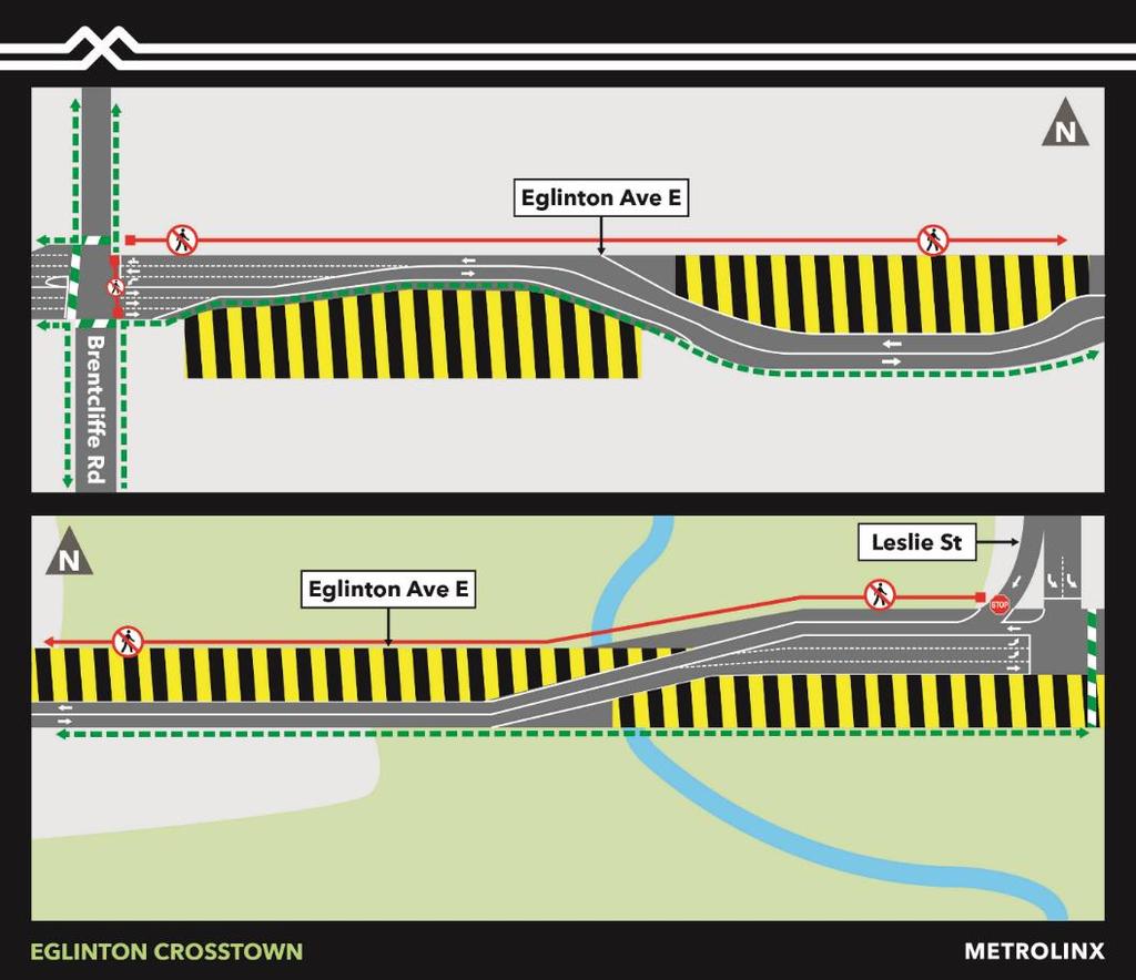
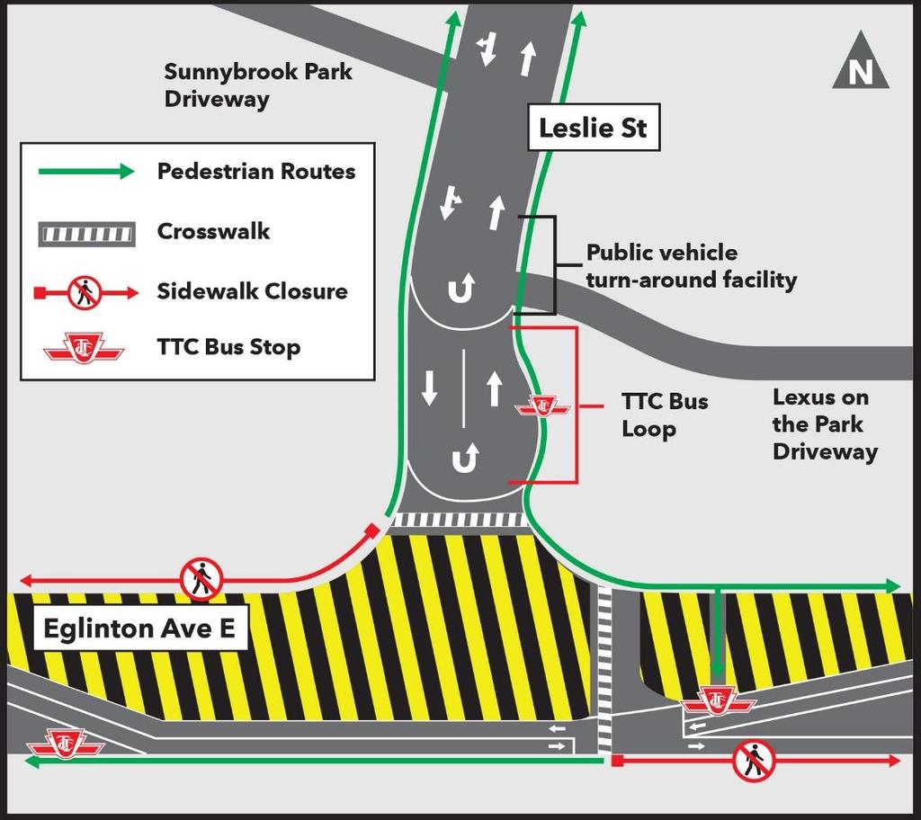
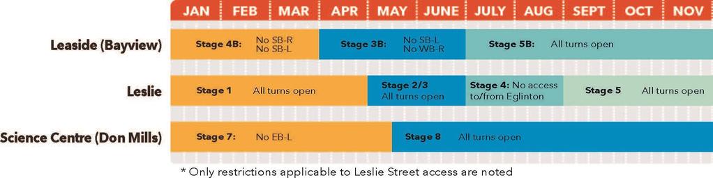
17
18
19 19


20


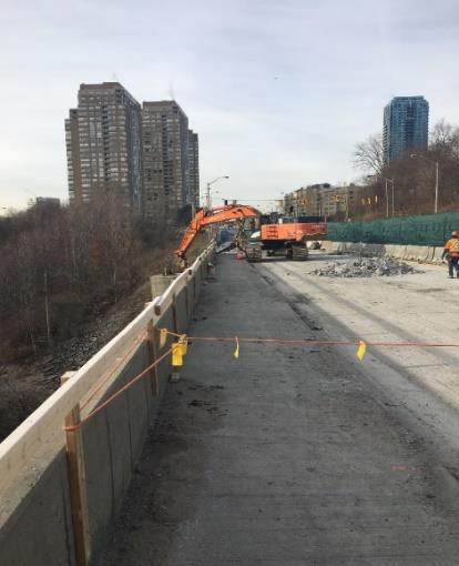
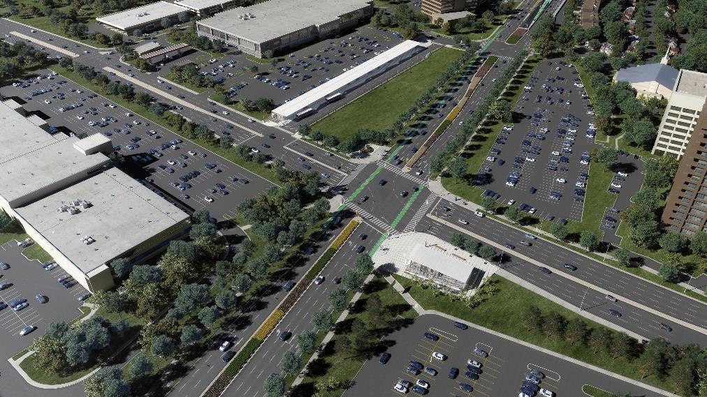
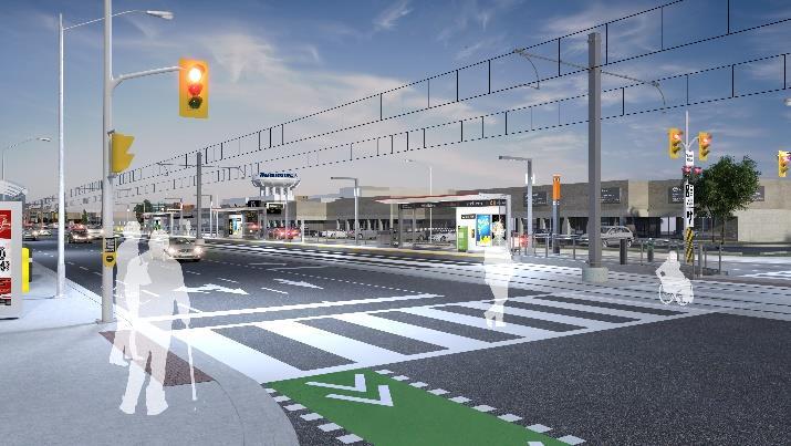
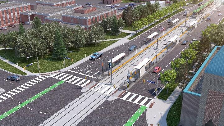
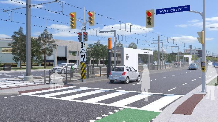
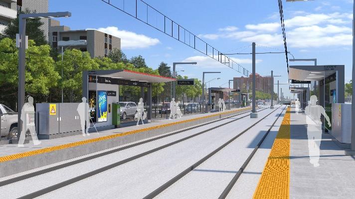
21 Eglinton Avenue East - Final Configuration O Connor Stop at Victoria Park and Eglinton Avenue
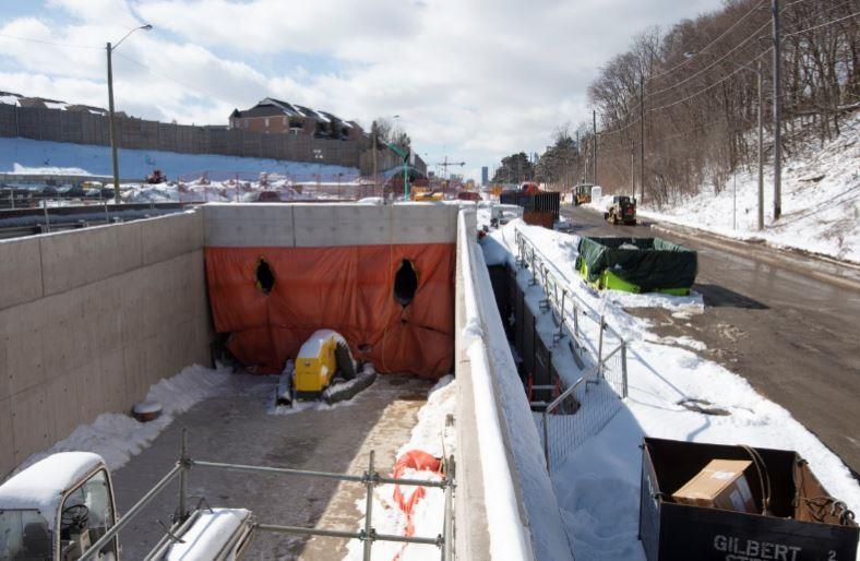
22 Brentcliffe Portal


23


24
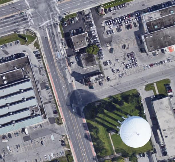
25 July-August Traffic Restriction - Leslie/Eglinton Crosslinx is seeking city permits for a temporary eight week restriction on vehicles travelling between Leslie Street & Eglinton Avenue East Allows for LRT guideway construction & track installation. Eglinton Avenue will remain open in both directions at all times. Leslie Street will otherwise function normally. Traffic lanes will open up & turn restrictions will be lifted at Bayview/Eglinton & Don Mills/Eglinton before the Leslie work starts. Proposed timeline is during the lowest traffic volume months. Emergency services access to and from Eglinton Avenue will be maintained at all times. Pedestrian & cyclist access between Leslie Street and Eglinton Avenue will be maintained throughout the closure. The entry to Sunnybrook Park off Leslie Street north of Eglinton Avenue is outside the work zone and will be open. 25

26
27
28 Why Restrict Some Traffic and Transit Access at Leslie? Keeping the intersection open for all traffic and transit access would require carrying the work out in a minimum of four stages resulting in: Extended disruption from construction from two to six months, including periods where traffic volume is greater than summer months. At least four (4) major changes in how traffic gets through the area; each stage of construction would be disruptive. Additional off-peak lane closures and intermediate traffic setups with associated restrictions required. Reduced quality of road when work is completed due to joints and higher future maintenance costs, with future road work required earlier or more frequently.

29 Lanes were realigned east of Leslie Street and west of the Celestica bridge for road widening and reconstruction works on the south side of Eglinton Avenue East. Work will continue until late April, 2019 and then shift to the north side of the street.


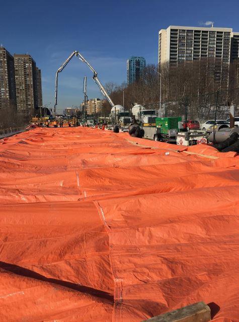
30 April 1: Road Widening and Paving 6 weeks To accommodate these traffic configurations, a temporary eastbound off ramp will be constructed at. the Don Valley Parkway West intersection. Short-term, intermittent closures of the north-south crosswalk at the Don Valley Parkway west ramp may be required for Stage 1. Mid-May: Guideway Construction 8 weeks An 8-week closure of the north-south crosswalk at the Don Valley Parkway west ramp will be required for stage 2. 30

31 New traffic configuration will be implemented at the intersection early April. This stage will be in place until May, A minimum of two through lanes of traffic in each direction will be maintained. A northbound through-lane will be implemented at the intersection for this stage. An eastbound left turn will be implemented at the intersection for this stage. 31 The south sidewalk west of Credit Union drive will remain closed. Eastbound and westbound TTC bus stops will be maintained. A temporary northbound TTC stop for the detoured Woodbine 91 bus will be installed at the south east corner of the intersection beginning April 15, 2019.
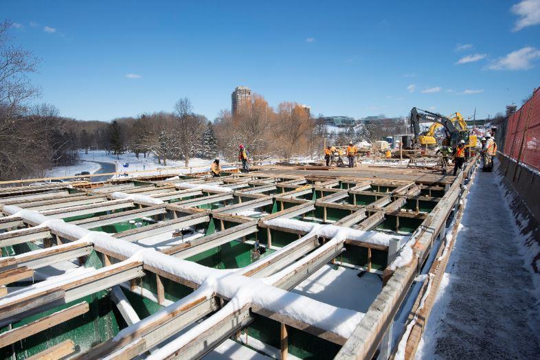
 weeks on each side.")

32 To accommodate road widening and paving activities along Eglinton Avenue East, two new traffic configurations will be implemented at Bermondsey Road. Traffic restrictions will be required for six (6) weeks on each side. Work is expected to begin as early as April 8 th, Work will not take place at adjacent intersections, emergency services access will be maintained and TTC detour routes will be communicated to the community.. 32


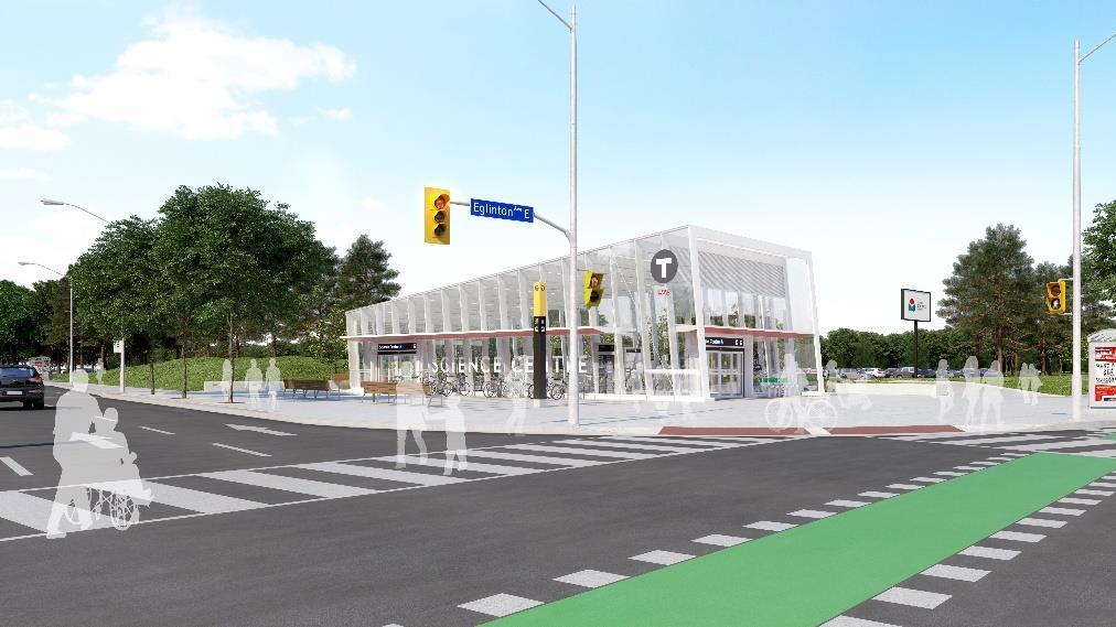
33 South Side Paving 6 weeks North Side Paving 6 weeks. 33


34

35 8
36 Brentcliffe Portal


37


38
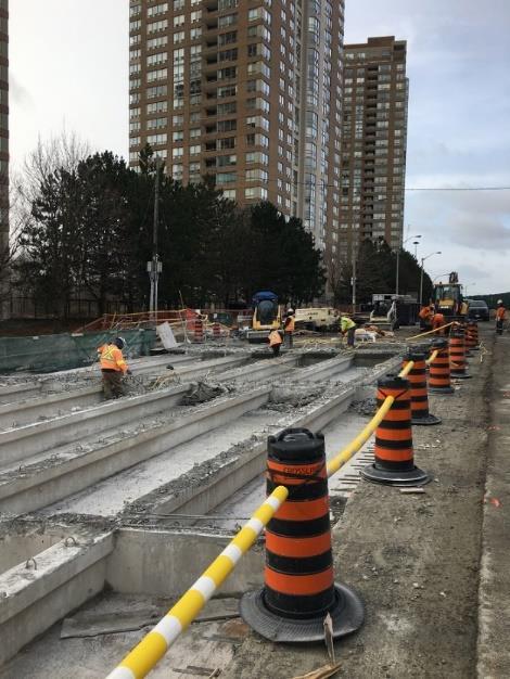
39


40 Station Box Excavation is ongoing under the decking Form work and rebar installation continues Upper north wall was poured Dewatering of ground water ongoing Main Entrance/Pedestrian Tunnels/Bus Terminal Form work and waterproofing activities in progress at the bus terminal Excavation has been completed at the pedestrian tunnel Duct bank poured at the main entrance Mud slab was poured at the at the pedestrian tunnel Excavation at the East Portal Excavation complete at Pedestrian Tunnel Portals Excavation continues Work continues on portal retaining walls Concourse Slab and Formwork
41 Brentcliffe Portal


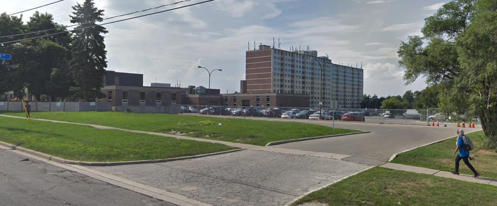
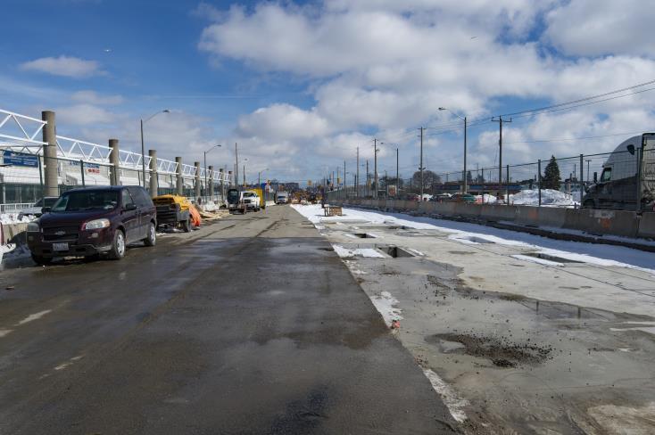
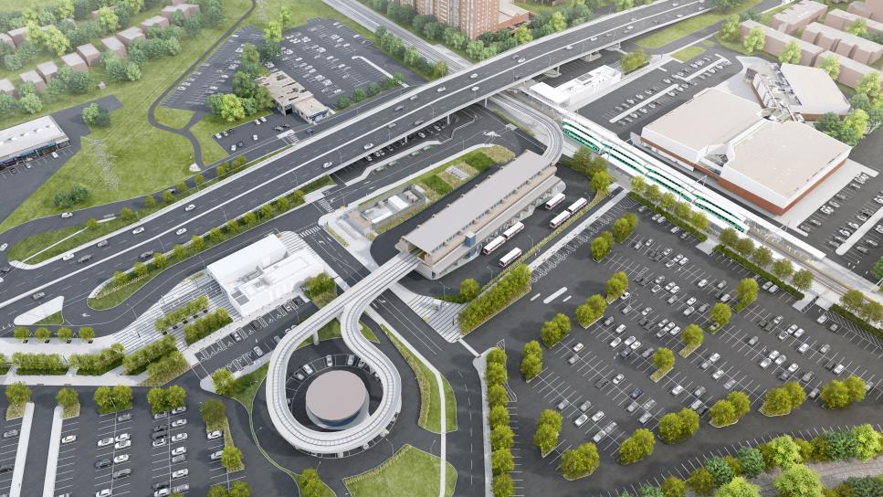
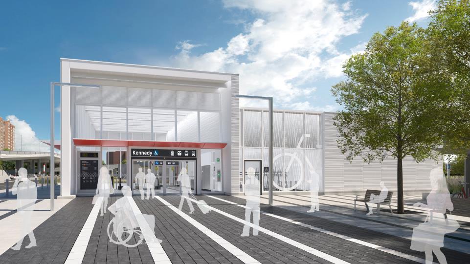
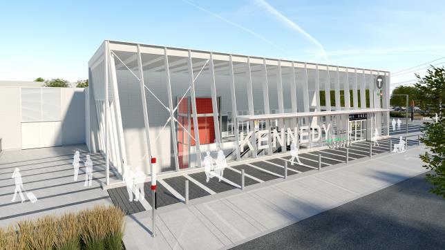
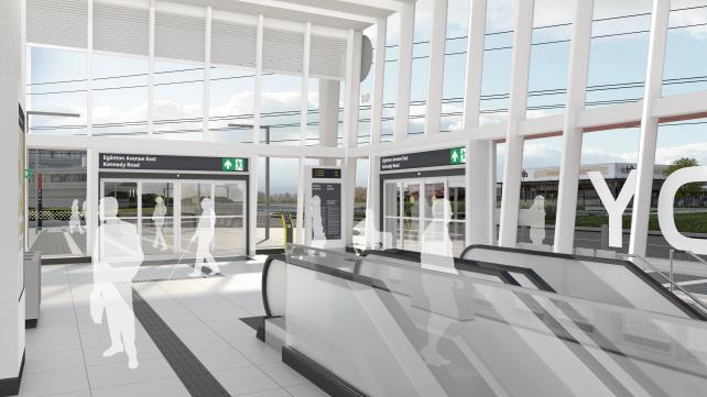
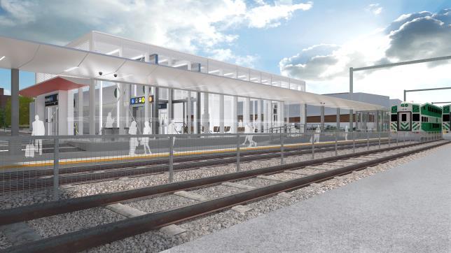
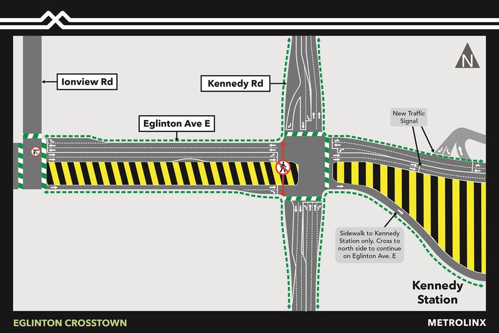
42 O Connor Stop to Ionview Stop Artist Renderings
43


44 Weekend Intersection Paving at Pharmacy Avenue 44


45 TTC Temporary Route Change- 67A and 67B 45


46

47


48 O Connor Stop to Ionview Stop Progress Photos


49
50


51 Current Staging: Kennedy Station 51


52 52


53 Kennedy Team- Vertical Pile Milestone Forming walls at West Portal M&E and Mud-Slab Main Entrance Compound Pile installation at Main Station Box
CROSSTOWN LRT Central Open House March 21, 2018
 CROSSTOWN LRT Central Open House March 21, 2018 Metrolinx was created in 2006 by the Province of Ontario to improve the coordination and integration of all modes of transportation in the Greater Toronto
2
 CROSSTOWN LRT 2 3 4 5 6 Construction of the Eglinton Crosstown LRT Line Background In September 2008, Metrolinx launched a regional transportation plan a 25-year, $50 billion plan -- to coordinate and
CROSSTOWN LRT Central-West Open House April 18, 2018
 CROSSTOWN LRT Central-West Open House April 18, 2018 Metrolinx was created in 2006 by the Province of Ontario to improve the coordination and integration of all modes of transportation in the Greater Toronto
2
 CROSSTOWN LRT 2 3 4 5 6 Construction of the Eglinton Crosstown LRT Line Background In September 2008, Metrolinx launched a regional transportation plan a 25-year, $50 billion plan -- to coordinate and
Eglinton West LRT Update
 Eglinton West LRT Update Community Consultation Update May 16, 2016 Background Rapid transit along Eglinton Ave between Kennedy Station and Pearson Airport was included in the Metrolinx Regional Transportation
3.5.7 Black Creek to Don Mills
 Toronto Transit Commission/City of Toronto 3.5.7.2 Keele Station Keele Station will be located at the intersection of Eglinton Avenue and Trethewey Drive/Keele Street. It will be the western-most station
Coordinated Transit Planning in Toronto SmartTrack GO RER Scarborough Relief Line Waterfront Transit
 Coordinated Transit Planning in Toronto SmartTrack GO RER Scarborough Relief Line Waterfront Transit Public Information Centres February 2016 Transportation Planning Section City Planning Division Toronto
Eglinton West/Allen Road Station Potential South Side Entrance Options. Online Consultation April 2 nd to April 16 th
 Eglinton West/Allen Road Station Potential South Side Entrance Options Online Consultation April 2 nd to April 16 th Eglinton West/Allen Road Station Consultation #1 Most common comment: south side entrance
Preliminary Construction & Traffic Planning Intro to Shop Local/Shop Eglinton Initiative. June 27, 2012
 Preliminary Construction & Traffic Planning Intro to Shop Local/Shop Eglinton Initiative June 27, 2012 Agenda Introductions Project Update Preliminary Crosstown Construction & Traffic Planning Overview
STATION AND STOP NAMES Eglinton Line. September 2015
 STATION AND STOP NAMES Eglinton Line September 2015 Naming Conventions. Why? There are ten transit agencies operating in the GTHA The planned construction of hundreds of kilometers of new rapid transit
Building the transportation network we need for the future
 Building the transportation network we need for the future WHO IS METROLINX? Metrolinx was created in 2006 by the Province of Ontario with a mandate to create greater connection between the communities
TORONTO TRANSIT COMMISSION REPORT NO.
 Form Revised: February 2005 TORONTO TRANSIT COMMISSION REPORT NO. MEETING DATE: NOVEMBER 17, 2009 SUBJECT: REQUEST FOR APPROVAL OF THE EGLINTON CROSSTOWN LRT TRANSIT PROJECT ASSESSMENT STUDY ACTION ITEM
WHY INVEST THE EGLINTON CONDOS
 WHY INVEST THE EGLINTON CONDOS By Mark Li Sales Representative Century 21 Leading Edge Realty Inc., Brokerage 416-500-5355 mark@mycondopro.com The Eglinton Yonge At Heart Yonge/Eglinton Area The Eglinton
1.3 TRANSIT VISION 2040 FROM VISION TO ACTION THEME 1: PUTTING TRANSIT AT THE CENTRE OF COMMUNITIES. Fully integrate transit with community planning
 TRANSIT VISION 2040 FROM VISION TO ACTION TRANSIT VISION 2040 defines a future in which public transit maximizes its contribution to quality of life with benefits that support a vibrant and equitable society,
Laird in Focus Community Information Session
 Laird in Focus Community Information Session Tuesday, December 5, 2017 St. Anslem Catholic School, 182 Bessborough Drive Session 1: 5:30 pm - Presentation and Question and Answer Period 6:15 pm - Breakout
ENHANCED EGLINTON WEST RAPID TRANSIT
 APPENDIX 4 ENHANCED EGLINTON WEST RAPID TRANSIT INITIAL BUSINESS CASE ANALYSIS JUNE 2016 Cover Image: Marcus Bowman TABLE OF CONTENTS Problem Statement II 1.0 Introduction 1 2.0 Context 2 3.0 Study Overview
MOBILITY HUB GUIDELINES 2012 TAC Sustainable Urban Transportation Award Submission BACKGROUND MOBILITY HUB GUIDELINES
 MOBILITY HUB GUIDELINES 2012 TAC Sustainable Urban Transportation Award Submission BACKGROUND Rapid population growth, increasing congestion, and years of under investment in transit in the Greater Toronto
Glen Road Pedestrian Bridge Environmental Assessment
 Glen Road Pedestrian Bridge Environmental Assessment Presentation to Design Review Panel July 18, 2017 Glen Road Pedestrian Bridge Class Environmental Assessment STUDY AREA Bloor Street East Streetscape
SCARBOROUGH SUBWAY EXTENSION. Scarborough Subway Extension. Final Terms of Reference
 Scarborough Subway Extension Final Terms of Reference 1 1.0 Introduction and Background 1.1 Introduction Toronto City Council recently confirmed support for an extension of the Bloor-Danforth Subway from
Subject: Transit Planning in Toronto: roles, priorities and our decision making framework
 INFORMATION ONLY Subject: Transit Planning in Toronto: roles, priorities and our decision making framework Date: July 29, 2015 At the TTC Board meeting on July 29, 2015, Jennifer Keesmaat, Chief Planner,
Welcome! MILLENNIUM LINE BROADWAY EXTENSION. Over the next 30 years, Metro Vancouver will welcome 1 million new residents and 600,000 new jobs.
 WELCOME Welcome! MILLENNIUM LINE BROADWAY EXTENSION Over the next 30 years, Metro Vancouver will welcome 1 million new residents and 600,000 new jobs. The Broadway Corridor is home to the second largest
APPENDIX 6 TRANSIT NETWORK ANALYSIS
 APPENDIX 6 TRANSIT NETWORK ANALYSIS 1. COORDINATED TRANSIT PLANNING Transit in Toronto Toronto's transit system is critical to the functioning of the Toronto city region. With the Toronto region population
The Commissioner of Engineering and Public Works recommends that this report be received for information purposes.
 COMMITTEE OF THE WHOLE FEBRUARY 1, 2011 407 TRANSITWAY - ENVIRONMENTAL PROJECT REPORT MINISTRY OF TRANSPORTATION CITY WIDE Recommendation The Commissioner of Engineering and Public Works recommends that
Strachan Ave. Overpass Community Design Update. October 26, 2010 Stephen Lipkus Executive Director Georgetown South Project GO Transit
 Strachan Ave. Overpass Community Design Update October 26, 2010 Stephen Lipkus Executive Director Georgetown South Project GO Transit Welcome Program Overview 6:30 8:30 p.m.: Storyboard Review Project
112th Avenue Light Rail Options Concept Design Report JUNE 2010 PREPARED FOR PREPARED BY TBG PGH
 112th Avenue Light Rail Options Concept Design Report JUNE 2010 PREPARED FOR PREPARED BY TBG060310124909PGH C ontents Introduction 1 Project Overview 1 Public Involvement and Technical Coordination 4 Description
GLEN ROAD PEDESTRIAN BRIDGE ENVIRONMENTAL ASSESSMENT STUDY PUBLIC INFORMATION CENTRE #2 OCTOBER 24, 2017
 GLEN ROAD PEDESTRIAN BRIDGE ENVIRONMENTAL ASSESSMENT STUDY PUBLIC INFORMATION CENTRE #2 OCTOBER 24, 2017 Glen Road Pedestrian Bridge Class Environmental Assessment 1 WELCOME! Welcome to the second Public
3 MARKHAM NORTH-SOUTH LINK CORRIDOR PUBLIC TRANSIT IMPROVEMENTS ENVIRONMENTAL ASSESSMENT UPDATE
 3 MARKHAM NORTH-SOUTH LINK CORRIDOR PUBLIC TRANSIT IMPROVEMENTS ENVIRONMENTAL ASSESSMENT UPDATE The Rapid Transit Public/Private Partnership Steering Committee recommends the adoption of the recommendations
Open House Wellesley Station Second Exit Construction Update and Public Art Concept
 Open House Wellesley Station Second Exit Construction Update and Public Art Concept YMCA 20 Grosvenor Street 1 Improvements coming to Wellesley Station Second Exit and Automatic Entrance Conceptual drawings
Don Mills Crossing Study and Celestica Lands Development Application Community Meeting, Open House, and Breakout Discussions
 Consultation Summary Don Mills Crossing Study and Celestica Lands Development Application Community Meeting, Open House, and Breakout Discussions This report is not intended to provide a verbatim transcript
Relief Line Project Assessment
 Relief Line Project Assessment Public Information Centre April 5, 2017 Tonight s Meeting PURPOSE To review the preferred alignment for the Local Segment. AGENDA 6:30 Open House 7:00 Presentation / Discussion
Canal Road City Limits (East of Van Dyke Ave) to Saal Road
 to Saal Road") Canal Road City Limits (East of Van Dyke Ave) to Saal Road Construction Update 9/14/2018 The ashalt paving on the southside of Canal Road is expected to start Saturday, September 15 (weather permitting)
Canal Road City Limits (East of Van Dyke Ave) to Saal Road Construction Update 9/14/2018 The ashalt paving on the southside of Canal Road is expected to start Saturday, September 15 (weather permitting)
Moving The Metro. A special construction update for the metro Omaha area.
 Moving The Metro A special construction update for the metro Omaha area. ebraska Department of Roads Spring/Summer 2017 I-80 / I-480 / US-75 Interchange The improvements on this project consist of bridge
SCARBOROUGH RAPID TRANSIT ENVIRONMENTAL PROJECT REPORT CHAPTER 2 PROJECT DESCRIPTION. Table 2-4: North Segment Alignment Analysis 2-21
 Table 2-4: North Segment Alignment Analysis 2-21 SCARBOROUGH RAPID TRANSIT Based on the above analysis (detailed analysis is contained in Appendix A-4), North Alignment 3 is preferred because it: Has the
TRANSPORTATION COMMITTEE
 TRANSPORTATION COMMITTEE CITY OF OTTAWA Ministry of Transportation Detailed Design Assignment G.W.P.# 4058-01-00 Highway 417 (Ottawa Queensway) Widening & Rehabilitation from Maitland Avenue to Island
Mount Dennis Mobility Hub Study Public Meeting December 12 th, :30pm 9:30pm York Memorial Collegiate, Cafeteria 2690 Eglinton Avenue West
 Mount Dennis Mobility Hub Study Public Meeting December 12 th, 2012 6:30pm 9:30pm York Memorial Collegiate, Cafeteria 2690 Eglinton Avenue West MEETING SUMMARY On December 12 th, 2012, over 89 people participated
DRAFT DRAFT DRAFT DRAFT
 # 19 EXPAND GREEN AND OPEN SPACES AND COMMUNITY FACILITIES IN TANDEM WITH NEW DEVELOPMENT The role of Eglinton will change in the coming years, along with the intensity of activity and land uses. As more
Bridge Type Assessment and Evaluation
 16M-01410-01 (3216026) Glen Road Pedestrian Bridge EA Study Bridge Type Assessment and Evaluation Factor Group/Criteria Alternative 1: Steel girder with two inclined steel legs Alternative 2: Steel girder
Port Credit Local Advisory Panel October 20 th Meeting
 Port Credit Local Advisory Panel October 20 th Meeting Focus Of This Evening s Meeting: 1. Hurontario Main Street Higher Order Transit Study 2. Port Credit Mobility Hub & GO Station Parking Structure Study
(blank page) WestConnex New M Roads and Maritime Services Environmental impact statement
 WestConnex New M Roads and Maritime Services Environmental impact statement") (blank page) WestConnex New M5 5-42 (blank page) WestConnex New M5 5-44 5.5 Tunnels 5.5.1 Main alignment tunnels The main alignment tunnels would be about nine kilometres long, with the western tunnel
(blank page) WestConnex New M5 5-42 (blank page) WestConnex New M5 5-44 5.5 Tunnels 5.5.1 Main alignment tunnels The main alignment tunnels would be about nine kilometres long, with the western tunnel
Reconfiguration of The Six Points Interchange. Community Update #2 June 18, 2014
 Reconfiguration of The Six Points Interchange Community Update #2 June 18, 2014 Outline 1. Project overview 2. How did we get here? 3. Etobicoke Centre 4. Existing and future road network 5. Design Update
VAUGHAN METROPOLITAN CENTRE STATION
 VAUGH VAUGH METROPOLIT STATION Located South West of 407 ETR and Jane Street intersection Five Level intermodal line station 600 Bay Commuter Parking Lot Passenger Pick-Up and Drop-Off (PPUDO) 18 bay Bus
FANSHAWE PARK ROAD/RICHMOND STREET INTERSECTION IMPROVEMENTS. PUBLIC INFORMATION CENTRE 2 June 16, 2016
 FANSHAWE PARK ROAD/RICHMOND STREET INTERSECTION IMPROVEMENTS Municipal Class Environmental Assessment PUBLIC INFORMATION CENTRE 2 June 16, 2016 ACCESSIBILITY Under the Accessibility Standards 2015 for
Victoria Bridge Municipal Class EA Civic Works Committee
 Municipal Class EA John Pucchio, P. Eng., Project Manager June 19 2018 Introduction Existing Conditions Municipal Class EA Proposed Bridge Proposed Road Reconstruction Proposed Improvements Construction
GOLDEN MILE SECONDARY PLAN. Community Consultation Meeting #3 June 26, 2018
 GOLDEN MILE SECONDARY PLAN Community Consultation Meeting #3 June 26, 2018 Meeting Overview 1. Introduction 2. Principles + Vision 3. Street + Block Alternatives 4. Parks + Open Space Alternatives 5. Land
Adelaide Street / Canadian Pacific Railway (CPR) Grade Separation Class Environmental Assessment. Public Information Centre 3
 Grade Separation Class Environmental Assessment. Public Information Centre 3") 1 Adelaide Street / Canadian Pacific Railway (CPR) Grade Separation Study Process and Purpose of PIC 3 2 Study Commencement February 2016 Phase 1: Problem and Opportunity Identify problems and opportunities
1 Adelaide Street / Canadian Pacific Railway (CPR) Grade Separation Study Process and Purpose of PIC 3 2 Study Commencement February 2016 Phase 1: Problem and Opportunity Identify problems and opportunities
Right-of-Way Acquisitions and Relocations Technical Memorandum
 Right-of-Way Acquisitions and Relocations Technical Memorandum Southeast Extension Project Lincoln Station to RidgeGate Parkway Prepared for: Federal Transit Administration Prepared by: Denver Regional
Allen Road-Eglinton West Station Public Consultation Report Open House & Online Consultation #1
 Allen Road-Eglinton West Station Public Consultation Report Open House & Online Consultation #1 March 2, 2012 2 Allen Road Eglinton West Station Consultation Table of Contents 1. Executive Summary... 4
Edmonton s LRT Setting the Stage for Heading Further South
 4 Capital Projects Project Updates Edmonton s LRT Setting the Stage for Heading Further South Art Washuta, P.Eng. AECOM Canada Ltd. Edmonton, Alberta Carole Cej, P.Eng. City of Edmonton Edmonton, Alberta
ROAD CONSTRUCTION. 36 June 2014 ROADS&BRIDGES
 ROAD CONSTRUCTION 36 June 2014 ROADS&BRIDGES Young is full of life Recent expansion completes continuous, multilane arterial By Donald Hammack, P.E. Contributing Author The Florida Department of Transportation
Assessing City of Toronto and Metrolinx Rapid Transit Priorities
 STAFF REPORT ACTION REQUIRED Assessing City of Toronto and Metrolinx Rapid Transit Priorities Date: June 3, 2013 To: From: Ward: Reference Number: Planning and Growth Management Committee Chief Planner
Planning and Growth Management Committee. Acting Chief Planner and Executive Director, City Planning Division
 STAFF REPORT ACTION REQUIRED Eglinton Planning Study Status Report Date: August 23, 2012 To: From: Planning and Growth Management Committee Acting Chief Planner and Executive Director, City Planning Division
St. Clair Avenue West Area Transportation Master Plan
 1 (Between Keele Street and Old Weston Road) Public Information Centre 1 December 2, 2015 2 Welcome Welcome to the first Public Information Centre for the St. Clair Avenue West Area. The panels will present
Scarborough Centre Transportation Master Plan Final Report
 REPORT FOR ACTION Scarborough Centre Transportation Master Plan Final Report Date: April 11, 2018 To: Scarborough Community Council From: Director Transit and Transportation Planning and Director Community
Shift Rapid Transit Public Participation Meeting May 3, 2017
 Shift Rapid Transit Public Participation Meeting May 3, 2017 Shift Rapid Transit Initiative Largest infrastructure project in the city s history. Rapid Transit initiative will transform London s public
Chicago Presentation March 31, 2009
 Chicago Presentation March 31, 2009 1 agenda Section One York Region and the GTHA Section Two Making Our Vision a Reality Section Three Our Project Section Four What s Next for Viva 2 york region and the
What s Up Next In The Seattle Squeeze. PSRC Transportation Policy Board April 11
 What s Up Next In The Seattle Squeeze PSRC Transportation Policy Board April 11 1 Current construction Alaskan Way Viaduct removal Removes the viaduct (including foundations and ramps) and restores the
Key Themes and Responses May 2016
 King and Victoria Transit Hub and Waterloo Street Pedestrian Access Key Themes and Responses May 2016 The following summarizes what Regional staff heard about the King Victoria Transit Hub and Waterloo
Adelaide Street / Canadian Pacific Railway (CPR) Grade Separation. Public Information Centre #1
 Grade Separation. Public Information Centre #1") 1 Adelaide Street / Canadian Pacific Railway (CPR) Why Are We Here? 2 The purpose of Public Information Centre (PIC) #1 is to: Introduce the study Provide the study background and context Identify the
1 Adelaide Street / Canadian Pacific Railway (CPR) Why Are We Here? 2 The purpose of Public Information Centre (PIC) #1 is to: Introduce the study Provide the study background and context Identify the
Coxwell Station Easier Access
 Coxwell Station Easier Access Construction Update and Public Art Concept Danforth Mennonite Church 1 Coxwell Station Easier Access Strathmore Blvd Looking North Street Level Elevator E2 Concourse Outline
Finch Avenue West and Sheppard Avenue East Corridors - Planning Study Approach. Planning and Growth Management Committee
 PG8.9 STAFF REPORT ACTION REQUIRED Finch Avenue West and Sheppard Avenue East Corridors - Planning Study Approach Date: October 13, 2015 To: From: Planning and Growth Management Committee Chief Planner
Moving from Vision to Action
 Moving from Vision to Action Photo: John Carvalho What does it mean for a city to move? To see its people belong and connect? To prosper? To become green? Those are the pillars that are helping Mississauga
COUNCIL ATTACHMENT 2 HIGHWAY 7 CORRIDOR AND VAUGHAN NORTH-SOUTH LINK
 COUNCIL ATTACHMENT 2 HIGHWAY 7 CORRIDOR AND VAUGHAN NORTH-SOUTH LINK Welcome! The purpose today is to: Present the Study Background; Describe Alignment Alternatives Analyzed; Present the Evaluation of
Burloak Drive Grade Separation
 Burloak Drive Grade Separation Transit Project Assessment Process Public Meeting #1 March 30, 2017 GO Lakeshore West Service Plan Weekday Rush Hour 15-minute, two-way service between Aldershot* and Union
WELCOME TO OPEN HOUSE TWO November 28, 2018
 Langstaff Road Weston Road to Highway 7 Class Environmental Assessment Study WELCOME TO OPEN HOUSE TWO November 28, 2018 Please sign in and join our mailing list Study Overview York Region is conducting
METRO Gold Line BRT CMC Meeting
 METRO Gold Line BRT CMC Meeting April 26, 2018 Today s Topics Welcome and Introductions Project Overview CMC Roles and Responsibilities Current Project Baseline: Scope and Cost Estimate Overview Municipal
Transit-supportive development and city-building
 Photo: Michael Hiemstra (CC BY 2.0) Transit-supportive development and city-building Brief 3: Tools for building infrastructure and policy conditions Building the policy and infrastructure conditions Municipalities
Relief Line Project Assessment
 6/9/2015 Relief Line Project Assessment Stakeholder Advisory Meeting #2 June 9, 2015 Meeting Purpose Report on the Evaluation Results for Potential Station Locations Seek your Input on Potential Corridors
7.5 Impacts on the Section 4(f) Properties
 Properties") constructive use, such as noise, air quality and visual impacts were also assessed. It was determined that this project would not introduce changes of an external nature that would affect the recreational
constructive use, such as noise, air quality and visual impacts were also assessed. It was determined that this project would not introduce changes of an external nature that would affect the recreational
I-75/I-475 Interchange Upgrade Project Informational Meeting Tuesday, July 27, 2010
 I-75/I-475 Interchange Upgrade Project Informational Meeting Tuesday, July 27, 2010 I-75/I-475 Interchange Upgrade Project David R. Dysard, AICP District Two Deputy Director Theresa Pollick Public Information
Mavis Road Class Environmental Assessment
 Mavis Road Class Environmental Assessment Public Information Centre #2 Wednesday November 9, 2016 6:00 to 8:00 p.m. Please sign in and complete a comment sheet Review the displays on your own or join in
2. SHAPING THE CITY URBAN REGION 2.1 BUILDING A MORE LIVEABLE
 2. SHAPING THE CITY Toronto s future is one of growth, of rebuilding, of reurbanizing and of regenerating the City within an existing urban structure that is not easy to change. Population growth is needed
Expo Line Transit Project. Project Status Update Meeting West End Corridor Segment C
 Exposition Light Rail Transit Project Project Status Update Meeting West End Corridor Segment C Culver City Senior Center November 18, 2010 Phase 1 Project Description Phase 1 from Downtown Los Angeles
Relief Line Project Assessment
 Relief Line Project Assessment Stakeholder Advisory Meeting #4 May 30, 2016 Tonight s Meeting PURPOSE To present and discuss: Results of the evaluation of potential alignments Emerging preferred alignment
TORONTO TRANSIT COMMISSION REPORT NO.
 Form Revised: February 2005 TORONTO TRANSIT COMMISSION REPORT NO. MEETING DATE: AUGUST 26, 2009 SUBJECT: REQUEST FOR APPROVAL OF THE SCARBOROUGH-MALVERN LRT ENVIRONMENTAL ASSESSMENT STUDY ACTION ITEM RECOMMENDATION
Purpose of Open House #3
 Public Meeting #3 May 9, 2009 MVVA Team Purpose of Open House #3 The main purpose of this Open House is to present and seek input on the: Evaluation of transportation and infrastructure design alternatives
Public Meeting #3 May 9, 2009 MVVA Team
 Public Meeting #3 May 9, 2009 MVVA Team Welcome to the third Public Meeting for the Lower Don Lands Municipal Class Environmental Assessment (EA) Infrastructure Master Plan and Keating Channel Precinct
770 Don Mills Road and 805 Don Mills Road - Official Plan Amendment and Zoning By-law Amendment Application Preliminary Report
 REPORT FOR ACTION 770 Don Mills Road and 805 Don Mills Road - Official Plan Amendment and Zoning By-law Amendment Application Preliminary Report Date: To: From: Wards: June 22, 2018 North York Community
Places29: List of Implementation Projects
 Important Points to Keep in Mind When Using This List Places29: List of s Each of the projects in this List represents an action needed to implement the Places29 Master Plan. The projects are grouped first
M4-M5 Link Rozelle Interchange factsheet 2017
 M4-M5 Link Rozelle Interchange factsheet 017 WestConnex is part of the ustralian and NSW governments vision for supporting Sydney s growing population and keeping our economy strong. The M4-M5 Link is
Mobility Hub Guidelines: Tools for Achieving Successful Station Areas
 Mobility Hub Guidelines: Tools for Achieving Successful Station Areas This paper introduces Metrolinx s recently released Mobility Hub Guidelines and highlights two key aspects of the document: the importance
Richmond Road Complete Street Meeting #1, April 25, 2016
 Richmond Road Complete Street Meeting #1, April 25, 2016 Agenda Overview Richmond Road Complete Street Other Ongoing Studies Discussion Map buses/day removed from Sir John A. Macdonald Parkway Confederation
PLZ HD Broker/Floorplan BrochureReV3.indd 1-2
 PLZ 31538 HD Broker/Floorplan BrochureReV3.indd 1-2 This is Plaza Midtown THIS IS PLAZA MIDTOWN. Much like the area itself, Plaza Midtown is a bit of everything for everyone. Its modular, Rubik s cube
Hurontario/Main Street Corridor Master Plan Mississauga and Brampton Building a new and integrated vision for the corridor
 Hurontario/Main Street Corridor Master Plan Mississauga and Brampton Building a new and integrated vision for the corridor Martin Powell, Commissioner of Transportation and Works, City of Mississauga Paper
AGINCOURT SECONDARY PLAN
 1 AGINCOURT SECONDARY PLAN 1. AGINCOURT SECONDARY PLAN The following policies and principles apply to the area herein referred to as Agincourt, as outlined on Map 1-1. 1. GENERAL POLICIES 1.1 This Secondary
1 Introduction. Chapter. In this chapter:
 Chapter 1 Introduction In this chapter: 1.1 A Snapshot of the Region 1.2 Towards a Sustainable Region 1.3 The Provincial Context 1.4 Purpose and Organization The Regional Municipality of York Official
Ashland BRT Environmental Assessment: logos of CTA, CDOT, Chicago Department of Housing and Economic Development
 Ashland BRT Environmental Assessment: logos of CTA, CDOT, Chicago Department of Housing and Economic Development Overview The Chicago Transit Authority (CTA), in partnership with the Chicago Department
2016 REVISIONS COMMENT FORM RULES AND REGULATIONS FOR CONSTRUCTION IN THE PUBLIC WAY COMMENT PERIOD: JUNE 1 TO JUNE 30, 2015
 AGENCY: 2016 REVISIONS COMMENT FORM Section Title Number Chapter 1 Introduction Comment 1.1 CDOT Mission Statement 1.2 Purpose of Rules and Regulations for Construction in the Public Way 1.3 Chicago Department
Welcome to the Public Consultation Exhibition
 Welcome to the Public Consultation Exhibition Today is your opportunity to: Speak to the team Learn more about the project Leave feedback on the plans The Secretary of State for Transport has recognised
New. Stations. Smart Track I tlo MTDRONIO. Public Information Centre
 Public Information Centre New Smart Track I tlo - - -E>- - Stations Public Information Centre. King-Liberty SmartTrack Station. St. Clair-Old Weston SmartTrack Station. Spadina-Front GO Station. Bloor-Lansdowne
9 CITY OF VAUGHAN OFFICIAL PLAN AMENDMENT NO BOCA EAST INVESTMENTS LIMITED
 9 CITY OF VAUGHAN OFFICIAL PLAN AMENDMENT NO. 631 - BOCA EAST INVESTMENTS LIMITED The Planning and Economic Development Committee recommends the adoption of the recommendations contained in the following
Eastside Transit Corridor Phase 2 Technical Study Update Community Outreach Meeting February 2017
 Eastside Transit Corridor Phase 2 Technical Study Update Community Outreach Meeting February 2017 Purpose of Tonight s Meeting Recap of Board motion (2014) and technical study process Provide update on
The Master Plan Framework
 The Master Plan Framework The East Harbour Master Plan advances the development of 60 acres of former industrial lands east of the Don River. The Master Plan outlines a vision for a vibrant, transit-oriented
Inner Sunset Streetscape Improvement Project. Operations and Customer Service Committee July 11, 2017
 Inner Sunset Streetscape Improvement Project Operations and Customer Service Committee July 11, 2017 1 Inner Sunset Streetscape Improvement Project Inner Sunset Streetscape Improvement Project sfmta.com/innersunset
WELCOME and introduction
 1 WELCOME and introduction Mobility Hub Locations within Burlington STUDY OVERVIEW STUDY OBJECTIVES The City of Burlington is developing four Area Specific Plans, one for each of Burlington s Mobility
3. Endorse the LRT vision in transforming Surrey into Connected-Complete-Livable communities, and more specifically, the official vision statement:
 CORPORATE REPORT NO: R038 COUNCIL DATE: February 20, 2017 REGULAR COUNCIL TO: Mayor & Council DATE: February 16, 2017 FROM: General Manager, Engineering FILE: 8740-01 SUBJECT: Surrey Light Rail Transit
Summary of Results from the Toronto Planning Review Panel Meeting held June 10, 2017 Executive Summary
 Summary of Results from the Toronto Planning Review Panel Meeting held June 10, 2017 Executive Summary The Planning Review Panel is a representative group of Torontonians, made up of 28 randomly selected
Public input has been an important part of the plan development process.
 Lakewood s Comprehensive Plan recognizes that transportation helps shape the community, and that the way the community provides for the safe and efficient movement of people affects the character of the
Chapter 8. Visualizations
 Examples of Effective Techniques for Improving the Quality of Environmental Documents Chapter 8. Visualizations Visualizations help the reader to see what the project would look like in the real world.
844 Don Mills Road & 1150 Eglinton Avenue East - Official Plan Amendment Application - Preliminary Report
 STAFF REPORT ACTION REQUIRED 844 Don Mills Road & 1150 Eglinton Avenue East - Official Plan Amendment Application - Preliminary Report Date: July 10, 2014 To: From: Wards: Reference Number: Planning and
New Official Plan Quest November 2013
 City of Markham New Official Plan Quest November 2013 Building Markham s Future Together - 6 Key Strategic Priorities 1. Growth - Managing our Growth 2. Transportation/Transit - Improving transportation