OCEAN POND COTTAGE DEVELOPMENT PLAN
|
|
|
- Joleen Richards
- 6 years ago
- Views:
Transcription
1 Edinburgh Group Limited 36 Cabot Avenue St. John s, NL A1A 5L9 OCEAN POND COTTAGE DEVELOPMENT PLAN ENVIRONMENTAL ASSESSMENT REGISTRATION JULY, 2014
2 TABLE OF CONTENTS Page 1. NAME OF UNDERTAKING PROPONENT Name of Body Address Chief Executive Officer Contact Person THE UNDERTAKING Nature of Undertaking Purpose/Rationale/Need for the Undertaking DESCRIPTION OF THE UNDERTAKING Geographic Location Physical Features Physical & Biological Environments Existing Site / Land Use Development Construction Operation Occupations Project Related Documents... 6
3 5. APPROVAL OF THE UNDERTAKING Project Individual Cottage Owners SCHEDULE FUNDING SUBMITTED... 7 APPENDIX I Preliminary Concept Plan...8 APPENDIX II Phase I Groundwater Assessment APPENDIX III Location Plan...10
4 OCEAN POND COTTAGE DEVELOPMENT PLAN ENVIRONMENTAL ASSESSMENT REGISTRATION 1. NAME OF UNDERTAKING Ocean Pond Cottage Development Plan 2. PROPONENT 2.1. Name of Body 2.2. Address Edinburgh Group Limited 36 Cabot Avenue St. John s, NL A1A 5L Chief Executive Officer Mr. Albert Williams, P. Eng Telephone: Contact Person Mr. Stephen Williams Telephone: Page 1
5 3. THE UNDERTAKING 3.1. Nature of Undertaking The project consists of the development of 110 recreational cottage lots in the Ocean Pond area. The development is an extension of existing cottage development in Ocean Pond. To facilitate this development it is proposed to construct approximately 3.7 km of Class C access road. The proposal will be a combination of waterfront and non-waterfront lots. Provisions will be made in the development to provide cottage owners and the general public access to the shoreline of Ocean Pond and the adjacent smaller pond. Access to the proposed development is via an extension of the existing Ocean Pond cottage access road. There will be no new access road connecting direct to the TCH created for this development Purpose/Rationale/Need for the Undertaking Ocean Pond is approximately one (1) hour drive from St. John s. The pond and surrounding area is a popular location for outdoor activities such as hunting, fishing, hiking and snowmobiling. The proposed development will address the growing demand for cottage lots on the Avalon and will ensure development occurs in a safe and environmentally sound manner. Development will take place as part of a planned cottage strategy, and it will occur in such a manner that the land base and surrounding environment will be preserved for the enjoyment of present and future users. For example, the new access road will have a 20-metre right-of-way and the road will be public. Also selected road accesses have been left for future development of Crown Lands in the adjacent access. 4. DESCRIPTION OF THE UNDERTAKING 4.1.Geographic Location Ocean Pond is located on the Avalon Peninsula and is accessible by the Trans Canada Highway( see Appendix III). The proposed Cottage Development Area is situated approximately six (6) kilometers east of the town of Whitbourne. It is an extension of the existing cottage lot development in Ocean Pond, as is located on the northwest side near the middle of the pond. The Ocean Pond cottage development encompasses an area of 48.6 hectares, plus 4.7 hectares of public access road. The area is surrounded entirely by Crown lands, and is outside the Page 2
6 planning boundaries of any municipality. The nearest existing development are cottages fronting on Western Gull Pond, which are located about 500 meters northeast of the site Physical Features Major physical features: The development will consist of one hundred ten (110), 0.4 hectares (minimum) unserviced cottage lots, totaling approximately 48.6 hectares. The 3.7 km of road development will have a 20 meter right-of way which will comprise a further 4.7 hectares. A preliminary concept plan showing location, design, lot areas and road layout is found in Appendix I Based on surficial geological mapping available for the area, the site sub-surface is characterised by glacial till; forming narrow, elongated ridge features that rise above the surrounding terrain, forming a series of closely-spaced gullies or deeply-incised channels; and forming hummocks having a random assemblage of knobs, mounds, ridges, and depressions. Based on a sieve analysis completed on a till sample from approximately 1 km northeast of the Site, the till is classified as a sand and gravel, with some silt. Minor bog is mapped within the property limits, though bog is more abundant on the adjacent lands. During the extensive agreement/review process between Crown Lands and the Garland Estate, preliminary engineering studies were carried out to reach an optimum layout that would minimize impact on any wetlands or sensitive areas. The proposed development area is privately owned land that was owned by the Garland family as part of a forest resource business. The original Garland grants covered extensive land areas in Ocean Pond and Whitbourne, and in 2013 Government and the Garland Estate reached agreement on a settlement of the land areas, which involved a significant reduction to the original grant. Edinburgh Group Limited acquired the Ocean Pond Lands from the Garland Estate. All lands surrounding this proposed development are owned by the Crown, and all new accesses constructed by the developer will be public roads built on Crown lands, to permit possible future expansion by Government. Approximately 29 of the proposed lots will have direct shoreline frontage on Ocean Pond, approximately 39 will have shoreline frontage on the adjacent smaller pond, and the remainder will be considered non-waterfront. This development has been given preliminary review by the Department of Environment, Water Resources Division and by Service NL. Further, as part of this review, a Phase I Groundwater Assessment was conducted by EXP Services Limited which concluded the site could support the development. Surface water runoff from the site drains toward Ocean Pond in the east or the smaller Pond 1 in the west. Ocean Pond is very large(6.5 km long and up to 1.4km wide), has a surface area of 400,000 m2, and drains southwest to the Page 3
7 Hodge River, ultimately discharging into the ocean about 20 km south of Colinet. Pond 1(0.9km long and up to 0.2km wide) has a surface area of 80,000 m2 and flows into East Pond, and on to Hooper s Pond and the Hodge River Physical and Biological Environments The development area is relatively flat to gently sloping terrain with surface topography ranging from 72m to 93m above sea level. In general, the land slopes toward either Ocean Pond or the adjacent smaller pond. Vegetation cover consists of typical Avalon Peninsula forest, predominately black spruce and larch in the wetter areas, with balsam fir and yellow birch on the drier sites. The proposed development area is adjacent to, and forms a natural extension of the existing cottage area on Ocean Pond. Wildlife consists of typical animal species found on the Avalon Peninsula. Fish in Ocean Pond are typical of those found in other Avalon Peninsula inland ponds,and consists mainly of trout species and American eel. Ocean Pond is not part of any salmon river system. The proposed development crosses no significant streams, and surface runoff is mainly intermittent overland flow Existing Site / Land Use Although this area was harvested years ago by the Garland family, there has been no commercial activity on the site for many years and the area consists of vacant forest lands. The pond is used for boating and recreational purposes by the cottage owners in the area. The existing access roads are maintained by the Ocean Pond Cottage Association, which charges an annual fee to the cottage owners. It is anticipated that this development would form part of this overall Association, and contribute to maintenance and management of the area for the benefit of everyone Development The development consists of 110 unserviced cottage lots, totaling approximately 48.6 hectares. The 3.7km of new road development, having a 20m right-of-way, will comprise a further 4.7 hectares. A preliminary site design has been laid out as shown in Appendix I. It is expected that the proposed lot lay out may change as terrain conditions warrant and the new roads have been completed. Each lot will have the capacity to be serviced by an on-site well and septic system in accordance with the Private Sewage Disposal and Water Supply Standard administered by Service NL. Tenure will be in the form of a freehold grant with all lots having legal surveys prior to allocation. Generally each lot will be 0.4 hectares in size with a 40-45m Page 4
8 frontage. Each lot will be evaluated for the installation of septic disposal system but individual lot owners will be responsible for ensuring that each lot has an approved septic system design prior to installation. Applicants will be responsible for road maintenance after the lots are allocated. Any proposal to develop on the fifteen (15) meter shoreline reservation must comply with Section 7 of the Lands Act Construction 4.7. Operation Description / Schedule: Construction associated with this proposal will be limited to 3.7 km gravel road construction and the works needed for installation of test pits and wells to meet regulatory requirements. Following installation of site access some thirty (30) test pits and five (5) wells will be constructed and monitored by EXP Services Limited for a three (3) month period. A detailed report will then be submitted for approval prior to cottage construction. It is anticipated it will be late fall 2014 before and final access road infrastructure or cottage development will take place. Individual cottages will be constructed by cottage lot owners according to their own schedules. Potential sources of pollutants: Potential sources of pollutants during the construction period will be those typically associated with road building and individual cottage construction (silt runoff into watercourses, leakage of fuels). Heavy equipment such as dump trucks, power shovels, backhoes and bulldozers are likely to be used during road construction; however there is no anticipated storage of fuels or other chemicals on site. All road construction will be undertaken according to existing government standards for environmental protection. Backhoes may also be used for installation of septic tanks and possibly bulldozers for localized grading to prepare ground for installation of foundations. While dust and noise are a concern for the public during any construction project, this site is located 0.5km from the end of the existing access road, and thus impacts on adjacent cottage owners should be minimal. The contractor will be instructed to minimize transport rotation of required heavy equipment, and to limit daily support operations to pickups or small trucks. Description: 110 cottage lots, each to be allocated to individual private Page 5
9 owners. All development will be serviced by on-site well and septic systems in accordance with Provincial Government standards. Estimated period of operation: Permanent (by each individual owner). Potential sources of pollutants: Cottage construction: Silt runoff, burning of vegetation during land clearing. Cottage occupations: Leakage from malfunctioning on-site waste disposal systems, if not maintained properly Occupations Estimated number of employees during construction: The road construction will be a tendered process and the number of employees will be determined by the contracted construction company. It is expected it would take 8-12 weeks. Two excavators, two off-road dump trucks, support equipment and up to six (6) employees would likely be onsite. Estimated number of occupations during operations: The project consists of 110 individually owned cottages which will be constructed according to schedules determined by the future lot owners Project-Related Documents Crown Land Planning Manual: Land Management Division, Department of Environment and Conversation, n.d. Cottage Development Planning in Newfoundland: Water Resources Management Division, Surface Water Section, Department of Environment and Lands, St. John s, EXP Services: Specialists Consulting Reports. 5. APPROVAL OF THE UNDERTAKING 5.1. Project Submitted by BAE-Newplan Group Limited for approval-in-principle on May 27, 2013 to: - Mr. Clyde McLean, P.Eng., Department of Environment and Conservation Page 6
10 - Ms. Dorothea W. Hanchar, M.Sc., Department of Environment and Conservation - Ms. Michelle Craig, P.Eng., Service NL - Department of Fisheries and Oceans Following feedback to above submissions, EXP Services were engaged to conduct a Level I Groundwater Assessment. Level I Groundwater Supply Assessment Final Report submitted January, Site visit and meetings with Department of Environment and Conservation and Service NL to confirm extent and locations for test pits, wells, and detailed field investigation program by EXP Services.. Individual cottages: Shall require septic design approval from the Government Service Centre. 6. SCHEDULE It is anticipated that final construction of the access road infrastructure will occur during the fall of 2014, following completion of the field investigation program and receipt of all required approvals. 7. FUNDING All development costs exclusive of individual cottage lots construction and installation of onsite servicing will accrue to Edinburgh Group Limited. All costs incurred will be recovered from cottage lot sales. 8. SUBMITTED Albert Williams, P. Eng Date Page 7
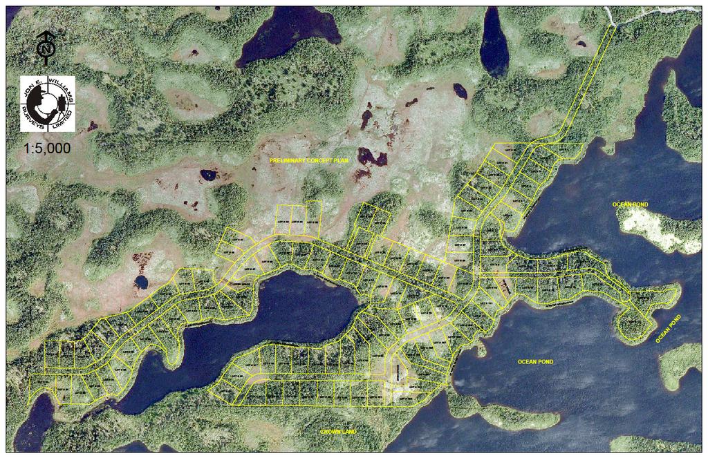
11 Appendix I Preliminary Concept Plan Page 8
12
13
BURNT BERRY POND COTTAGE DEVELOPMENT PLAN PHASE II ENVIRONMENTAL ASSESSMENT REGISTRATION
 GOVERNMENT OF NEWFOUNDLAND AND LABRADOR Department of Environment and Conservation Lands Branch, Land Management Division BURNT BERRY POND COTTAGE DEVELOPMENT PLAN PHASE II ENVIRONMENTAL ASSESSMENT REGISTRATION
PLACENTIA JUNCTION COTTAGE DEVELOPMENT PLAN (AMENDMENT NO. 2, 2010)
") Government of Newfoundland and Labrador Department of Environment & Conservation Lands Branch Land Management Division PLACENTIA JUNCTION COTTAGE DEVELOPMENT PLAN (AMENDMENT NO. 2, 2010) ENVIRONMENTAL
Government of Newfoundland and Labrador Department of Environment & Conservation Lands Branch Land Management Division PLACENTIA JUNCTION COTTAGE DEVELOPMENT PLAN (AMENDMENT NO. 2, 2010) ENVIRONMENTAL
BIG COOK S POND COTTAGE DEVELOPMENT PLAN ENVIRONMENTAL ASSESSMENT REGISTRATION
 GOVERNMENT OF NEWFOUNDLAND AND LABRADOR Department of Environment and Conservation Lands Branch, Land Management Division BIG COOK S POND COTTAGE DEVELOPMENT PLAN ENVIRONMENTAL ASSESSMENT REGISTRATION
April 11, 2016 Park Board Chair and Commissioners General Manager Vancouver Board of Parks and Recreation New Brighton Salt Marsh - Preferred Concept
 TO: FROM: SUBJECT: April 11, 2016 Park Board Chair and Commissioners General Manager Vancouver Board of Parks and Recreation New Brighton Salt Marsh - Preferred Concept RECOMMENDATION A. THAT the Vancouver
WEST HILL BUSINESS PARK AREA STRUCTURE PLAN
 MUNICIPAL DISTRICT OF PEACE NO. 135 WEST HILL BUSINESS PARK AREA STRUCTURE PLAN Prepared by: TABLE OF CONTENTS 1.0 Introduction... 1 1.1 Purpose of Plan........ 1 1.2 Plan Area..... 1 1.3 Existing Conditions...
Leduc Industrial Outline Plan SE W4
 Leduc Industrial Outline Plan SE 1-50-25-W4 Within the North Leduc Industrial ASP Prepared for: Leduc Energy Park Ltd. Prepared by: Stantec Consulting Ltd. File No. 1161 104655 V5 Table of Contents 1.0
LAND USE ASSESSMENT REPORT (LUAR) PROPOSED AFFORDABLE HOUSING COMPLEX MAIN ROAD PDE FILE NUMBER: REZ
 PROPOSED AFFORDABLE HOUSING COMPLEX MAIN ROAD PDE FILE NUMBER: REZ") LAND USE ASSESSMENT REPORT (LUAR) PROPOSED AFFORDABLE HOUSING COMPLEX 560-564 MAIN ROAD PDE FILE NUMBER: REZ13-00008 PREPARED FOR P.O. BOX 908 ST. JOHN'S, NL CANADA A1B 4C4 PROPONENT BROOKSIDE DEVELOPMENTS
LAND USE ASSESSMENT REPORT (LUAR) PROPOSED AFFORDABLE HOUSING COMPLEX 560-564 MAIN ROAD PDE FILE NUMBER: REZ13-00008 PREPARED FOR P.O. BOX 908 ST. JOHN'S, NL CANADA A1B 4C4 PROPONENT BROOKSIDE DEVELOPMENTS
OP Council Resolution June 16, Planning and Development Services
 OP-08-01 Council Resolution June 16, 2008 Planning and Development Services Kingsgate Landing Outline Plan Table of Contents 1.0 Introduction 1 1.1 Purpose of Plan 1 1.2 Plan Area Location 1 1.3 Ownership
7.0 SOCIAL, ECONOMIC, AND ENVIRONMENTAL ISSUES
 7.0 SOCIAL, ECONOMIC, AND ENVIRONMENTAL ISSUES The following list of social, economic, and environmental issues have been identified based on a preliminary inventory of resources in the project area, an
HURON COMMUNITY PLAN
 CITY OF KITCHENER DEPARTMENT OF DEVELOPMENT AND TECHNICAL SERVICES PD 94/7 HURON COMMUNITY PLAN Recommended by Planning and Economic Development Committee: October 31, 1994 Adopted by Kitchener City Council:
Procedures IV. V. Rural Road Design Option
 i IV. Procedures A. All applicants required to prepare a Conservation Design Subdivision shall provide the Planning Board with a conceptual conventional subdivision design as well as a proposed layout
Environmental Assessment Registration Report
 Environmental Assessment Registration Report Prepared For Environmental Assessment Division, Provincial Department of Environment and Climate Change On Behalf of Eastern Health HEALTH SCIENCES CENTER FLOOD
Planning and Public Consultation Process for the Preparation of a General Land Use Plan for South Port Kells TERMS OF REFERENCE
 APPENDIX "B" Planning and Public Consultation Process for the Preparation of a General Land Use Plan for South Port Kells TERMS OF REFERENCE PURPOSE South Port Kells is located in the northeastern quadrant
11. BALLANTRAE-MUSSELMAN LAKE AND ENVIRONS SECONDARY PLAN
 11. BALLANTRAE-MUSSELMAN LAKE AND ENVIRONS SECONDARY PLAN 11.1 PURPOSE The Ballantrae-Musselman Lake and Environs Secondary Plan Area includes two small existing settlement areas, Ballantrae and Musselman
13. VANDORF-PRESTON LAKE SECONDARY PLAN 13.1 INTRODUCTION
 13. VANDORF-PRESTON LAKE SECONDARY PLAN 13.1.1 Purpose 13.1 INTRODUCTION The Vandorf-Preston Lake Secondary Plan establishes the principles, objectives and general policies, as well as specific strategies
Chapter 4 - Preparation of Stormwater Site Plans
 Chapter 4 - Preparation of Stormwater Site Plans The Stormwater Site Plan is the comprehensive report containing all of the technical information and analysis necessary for the City to evaluate a proposed
NON-TECHNICAL SUMMARY
 Proposed Sand and Gravel Extraction and Associated Processing Operations with Restoration to a Mixture of Agriculture and Nature Conservation including Areas of Shallow Water at Hedgeley, Northumberland
McKay Road Interchange and Salem / Lockhart Crossing
 McKay Road Interchange and Salem / Lockhart Crossing The McKay Road Interchange Class EA has two components: 1. A new MacKay Road Interchange at Highway 400; and 2. A new bridge crossing of Highway 400
Central Lake Ontario Conservation Conservation Lands Master Plan
 Conservation Lands Master Plan Top 13 Frequently Asked Questions 1. What are conservation lands? Where are these conservation lands located in the Central Lake Ontario Conservation watershed? Conservation
FURTHER TO EXECUTIVE COMMITTEE MEETING #11/12 To be held on Friday, January 11, 2013
 FURTHER TO EXECUTIVE COMMITTEE MEETING #11/12 To be held on Friday, January 11, 2013 FURTHER TO: Pages EX10. APPLICATION FOR PERMITS UNDER ONTARIO REGULATION 166/06 Development, Interference with Wetlands
Fish Habitat Evaluation Report
 Fish Habitat Evaluation Report To: Jeff Lovegrove From: Rod Bilz Date: November 24, 2017 Subject: Gettings Property Part of Lot 28, Concession 2, Geographic Township of Brunel Introduction The client wishes
Fish Habitat Evaluation Report
 Fish Habitat Evaluation Report To: Jeff Lovegrove From: Rod Bilz Date: June 5, 2016 Subject: Gettings Property Part of Lot 28, Concession 2, Geographic Township of Brunel Introduction The client wishes
S o u t h C e n t r a l O u t l i n e P l a n. Leduc Business Park. North Leduc Industrial Area Structure Plan C it y of Led u c.
 Leduc Business Park North Leduc Industrial Area Structure Plan C it y of Led u c Prepared for Farm Air Properties Inc. January, 2007 Table of Contents Page Number 1.0 Purpose of Plan and Definition of
A Growing Community Rural Settlement Areas
 Town of Huntsville Official Plan Review - POLICY BACKGROUND PAPER A Growing Community Rural Settlement Areas BACKGROUND: In addition to the fully municipally-serviced Urban Settlement Area and the Hidden
ENBRIDGE GAS DISTRIBUTION INC. Proposed Relocation for Ninth Line, Markham and Whitchurch-Stouffville. Environmental Screening Report
 Page 1 of 18 ENBRIDGE GAS DISTRIBUTION INC. Proposed Relocation for Ninth Line, Markham and Whitchurch-Stouffville Environmental Screening Report July 2011 Page 2 of 18 Table of Contents 1.0 INTRODUCTION
City of Grande Prairie Development Services Department
 City of Grande Prairie Development Services Department ROYAL OAKS NORTH OUTLINE PLAN OP-07-03 NW 35-71-6 W6M May 7, 2007 Royal Oaks North Outline Plan TABLE OF CONTENTS 1.0 INTRODUCTION........ 3 1.1 Purpose
C ity of Grande Prairie Development Services Department
 C ity of Grande Prairie Development Services Department FAIRWAY DEVELOPMENT OUTLINE PLAN OP 08 09 Approved April 6, 2009 Prepared by: Focus Corporation Table of Contents 1.0. Introduction 2 3 1.1. Plan
Guide to Naturalizing a Lakefront Shoreline. September 2010
 Guide to Naturalizing a Lakefront Shoreline September 2010 Retaining walls and non-vegetated shorelines are a very common sight on shore-line properties in Alberta. These urbanized shorelines have a huge
M E M O R A N D U M. Chair and Members of North West Planning Advisory Committee
 Item 9.1.1 PO Box 1749 Halifax, Nova Scotia B3J 3A5 Canada M E M O R A N D U M TO: FROM: Chair and Members of North West Planning Advisory Committee Stephanie Salloum, Planner II DATE: June 26, 2017 SUBJECT:
APPENDIX A SIMPLIFIED APPROACH TO STORMWATER MANAGEMENT FOR SMALL PROJECTS. In West Sadsbury Township, Chester County, Pennsylvania
 APPENDIX A SIMPLIFIED APPROACH TO STORMWATER MANAGEMENT FOR SMALL PROJECTS In West Sadsbury Township, Chester County, Pennsylvania TABLE OF CONTENTS I. Introduction 3 II. Importance of Stormwater Management
Town of Huntsville Official Plan Section 8 Waterfront Policies Page 71
 Section 8 Waterfront Policies Page 71 8 WATERFRONT 8.1 DEFINITION AND FUNCTION Definition 8.1.1 The Waterfront includes those lands outside the Huntsville Urban Settlement Area, Hidden Valley and Port
A Guide to Open Space Design Development in Halifax Regional Municipality
 A uide to Open Space Design Development in Halifax Regional Municipality May 2007 1 Introduction Pursuant to Section 3.5 of the Regional Municipal Planning Strategy (RMPS), subdivision of land may proceed
MERIDAN PLAINS SAND RESOURCE AREA
 MERIDAN PLAINS SAND RESOURCE AREA INFORMATION SHEET October 2010 BACKGROUND The Meridan Plains Extractive Resource Area is located on the western fringe of the coastal urban communities of Caloundra West
6 PORT SYDNEY SETTLEMENT AREA
 Section 6 Port Sydney Page 61 6 PORT SYDNEY SETTLEMENT AREA 6.1 Basis and Principles Village of Port Sydney Waterfront Community Existing Services 6.1.1 Port Sydney is an historic settlement that has developed
Harrow Lane, St Leonards-on-Sea, East Sussex, TN37 7JZ ERECTION OF 113 DWELLINGS TOGETHER WITH ESTATE ROADS (DETAILED SUBMISSION)
") AGENDA ITEM NO: Report to: PLANNING BOARD Date: 10 September, 2003 Report from: Borough Planning Officer Application Address: Proposal: Application No: Recommendation: Ward: File No: Applicant: Interest:
AGENDA ITEM NO: Report to: PLANNING BOARD Date: 10 September, 2003 Report from: Borough Planning Officer Application Address: Proposal: Application No: Recommendation: Ward: File No: Applicant: Interest:
Services Department B September 10, 2007
 Report To: Development Services Committee Item: Date of Report: DS-07-246 September 5, 2007 From: Commissioner, Development File: Date of Meeting: Services Department B7200-0001 September 10, 2007 Subject:
-MENDOCINO COUNTY PLANNING AND BUILDING SERVICES- DIVISION II OF TITLE 20--COASTAL ZONING CODE
 CHAPTER 20.504 VISUAL RESOURCE AND SPECIAL TREATMENT AREAS Sec. 20.504.005 Applicability. Sec. 20.504.010 Purpose. Sec. 20.504.015 Highly Scenic Areas. Sec. 20.504.020 Special Communities and Neighborhoods.
Appendix I. Checklists
 Appendix I Checklists Town of Greenwich Drainage Manual Department of Public Works - Engineering Division Town Hall - 101 Field Point Road, Greenwich, CT 06836-2540 Phone 203-622-7767 - Fax 203-622-7747
SPG 1. * the northern and western sections which are open fields used for pasture and grazing;
 SPG 1 1.0 INTRODUCTION This development brief is based on the allocation of the Priors Hall site for employment and countryside recreational purposes in the Corby Borough Local Plan. The brief is intended
AMENDMENT NO. 30 TO THE OFFICIAL PLAN OF THE TOWN OF MILTON
 AMENDMENT NO. 30 TO THE OFFICIAL PLAN OF THE TOWN OF MILTON Subject: Boyne Survey Secondary Plan and Related Official Plan Amendments The following text and schedules constitute Amendment No. 30 to the
ARTICLE VI: SITE PLAN REVIEW
 Section 6.01 - Site Plan Review (All Districts) ARTICLE VI: SITE PLAN REVIEW Site plans give the Planning commission an opportunity to review development proposals in a concise and consistent manner. The
PURPOSE: The purpose is to provide commercial facilities in the Vancouver and Clark County vicinity.
 US Army Corps of Engineers Seattle District Joint Public Notice Application for a Department of the Army Permit and a Washington Department of Ecology Water Quality Certification and/or Coastal Zone Management
City of Surrey PLANNING & DEVELOPMENT REPORT File:
 City of Surrey PLANNING & DEVELOPMENT REPORT PROPOSAL: Planning Report Date: September 14, 2009 OCP Amendment Temporary Industrial Use Permit in order to allow the outdoor storage of construction waste
Hopwood Motorway Service Area, Worcestershire
 Hopwood Motorway Service Area, Worcestershire SuDS used Grass filter strip Stone collector trench Spillage basin Grass swale Balancing ponds Wetland ditch Wetland treatment Sub-surface collector trench
SECTION 4(f) DE MINIMIS DOCUMENTATION
 DE MINIMIS DOCUMENTATION") SECTION 4(f) DE MINIMIS DOCUMENTATION Illinois Route 60/83 IL 176 to the intersection of IL 60 (Townline Road) Lake County P-91-084-07 Mundelein Park and Recreation District Project Limit SECTION 4(f)
SECTION 4(f) DE MINIMIS DOCUMENTATION Illinois Route 60/83 IL 176 to the intersection of IL 60 (Townline Road) Lake County P-91-084-07 Mundelein Park and Recreation District Project Limit SECTION 4(f)
A Landowner s Guide to Creating Woodland Pools for Amphibians and Other Wildlife
 Cornell Department of Natural Resources Conservation Education Program Fact Sheet Kristi L. Sullivan and Stephen J. Morreale A Landowner s Guide to Creating Woodland Pools for Amphibians and Other Wildlife
Draft Rhode Island Stormwater Design and Installation Standards Manual
 Draft Rhode Island Stormwater Design and Installation Standards Manual Summary The May 2009 Public Review Draft version of the RI Stormwater Design and Installation Standards Manual consists of approximately
Carterton Construction Ltd is bringing forward plans for up to 85 new family homes and extra care facilities on land east of Burford.
 Welcome Carterton Construction Ltd is bringing forward plans for up to 85 new family homes and extra care facilities on land east of. We are at the early stages of designing our proposals and have a number
Development of land adjacent to Braggs Farm Lane and Rumbush Lane, Dickens Heath. Welcome. Today s exhibition. The proposal site
 Welcome Welcome to this event to discuss the development of land adjacent to Braggs Farm Lane. is currently in the preliminary stages of designing proposals to sensitively develop this site with high-quality
Station Street/Haig Road Extension Environmental Assessment (EA)Study. Welcome
Study. Welcome") Station Street/Haig Road Extension Environmental Assessment (EA)Study Welcome Welcome to this Public Information Centre (PIC) meeting. Please record your attendance and obtain a comment sheet at the registration
Station Street/Haig Road Extension Environmental Assessment (EA)Study Welcome Welcome to this Public Information Centre (PIC) meeting. Please record your attendance and obtain a comment sheet at the registration
PRELIMINARY DRAINAGE REPORT LATHAM 200 MMSCFD GAS PROCESSING PLANT
 PRELIMINARY DRAINAGE REPORT LATHAM 200 MMSCFD GAS PROCESSING PLANT LOTS B, RECORDED EXEMPTION 1211-2-1, RECX13-0096 LOCATED IN THE NORTH 1/2 OF SECTION 2, TOWNSHIP 3 NORTH, RANGE 66 WEST, 6 TH PRINCIPAL
Alternative Route Selection
 Alternative Route Selection Multiple routes are developed within the Alternative Corridors Developed by Project Team taking into account all information gathered to date Buildings St. Vital Station to
Section H: Waterfront
 Section H: Waterfront Waterfront Designation The waterfront designation describes the shoreline communities, which are located around the lakes or along the significant rivers in the Township. These communities
STORMWATER SITE PLAN INSTRUCTIONS AND SUBMITTAL TEMPLATE Medium and Large Projects
 DEPARTMENT OF COMMUNITY DEVELOPMENT 621 Sheridan Street, Port Townsend, WA 98368 Tel: 360.379.4450 Fax: 360.379.4451 Web: www.co.jefferson.wa.us/communitydevelopment E-mail: dcd@co.jefferson.wa.us STORMWATER
THREE-STEP DESIGN PROCESS FOR OPEN SPACE SUBDIVISIONS
 00216106.DOC NMA/RRK 1/30/14 THREE-STEP DESIGN PROCESS FOR OPEN SPACE SUBDIVISIONS Open space subdivisions, sometimes called cluster developments, maintain a significant portion of a development site in
Environmental Protection Ordinances (Performance Zoning) Bedminster Township, Bucks County
 Bedminster Township, Bucks County") Environmental Protection Ordinances (Performance Zoning) Bedminster Township, Bucks County ARTICLE VI. PERFORMANCE STANDARDS Section 600 Compliance All uses, activities, subdivisions and/or land developments
Environmental Protection Ordinances (Performance Zoning) Bedminster Township, Bucks County ARTICLE VI. PERFORMANCE STANDARDS Section 600 Compliance All uses, activities, subdivisions and/or land developments
STAFF REPORT FOR STANDARD COASTAL DEVELOPMENT PERMIT #CDP FEBRUARY 26, 2015 CPA - 1 PO BOX 238 APTOS, CA 94001
 STAFF REPORT FOR STANDARD COASTAL DEVELOPMENT PERMIT #CDP 2014-0030 FEBRUARY 26, 2015 CPA - 1 OWNER/APPLICANT: AGENT: REQUEST: HANS HEIM PO BOX 238 APTOS, CA 94001 JAMES HAY PO BOX 762 MENDOCINO, CA 95460
Plan of Development Mountain Valley Pipeline Project. APPENDIX M Winter Construction Plan
 APPENDIX M October 20, 2017 Appendix M Prepared by: October 20, 2017 TABLE OF CONTENTS 1.0 INTRODUCTION... M-1 2.0 STABILIZATION/WINTERIZATION... M-2 3.0 EROSION AND SEDIMENT CONTROL MEASURES... M-3 4.0
K. SMART ASSOCIATES LIMITED
 Planning Justification Report Zoning By-Law Amendment 185 King Street North Waterloo, Ontario April 7th, 2017 Project Reference Number 16-245 K. SMART ASSOCIATES LIMITED CONSULTING ENGINEERS AND PLANNERS
Manor Ponds, Sheffield
 Manor Ponds, Sheffield SuDS used Ponds Basins Benefits 1. Location Substantial improvement in amenity and biodiversity value. Effective stormwater treatment. Engagement/educational opportunity for all
APPLICATION BRIEFING Prepared For: Submitted by: Date: Subject:
 Planning & Development APPLICATION BRIEFING Prepared For: Submitted by: Date: Subject: Planning Advisory Committee Jason Fox, Director of Planning & Development Development Agreement application by Godfrey
TO BE COMPLETED BY APPLICANT
 Planning Division #200-2564 Shaughnessy Street Port Coquitlam BC V3C 3G4 Tel 604.927.5442 Fax 604.927.5404 Email planning@portcoquitlam.ca Application for Watercourse Development Permit Watercourse Development
The MSII reports for the bridge indicate that the Annual Average Daily Traffic at the bridge is 100. The road can be considered a low volume road.
 Page 1 1 INTRODUCTION 1.1 Background The Bronk Road Bridge is located on Bronk Road about 0.2 km north of Thrasher Road and spans Parks Creek, a tributary of the Moira River. Bronk Road is the road allowance
ADMINISTRATION RECOMMENDATION 2016 November 03. That Calgary Planning Commission recommends APPROVAL of the proposed Land Use Amendment.
 Page 1 of 12 EXECUTIVE SUMMARY This Land Use Amendment application covers an area of 75.76 hectares ± (187.20 acres ±) located in northeast Calgary, bound by Stoney Trail NE to the north, 128 Avenue NE
East Panorama Ridge Concept Plan Amendment
 Page 1 of 7 L003 : East Panorama Ridge Concept Plan Amendment Corporate NO: L003 Report COUNCIL DATE: March 4, 2002 REGULAR COUNCIL LAND USE TO: Mayor & Council DATE: February 27, 2002 FROM: General Manager,
APPENDIX F: EXTERNAL APPROVALS
 1.0 RESPONSIBILITIES When the City is constructing the Park or Open Space Development lands (OPTION I), after the subdivision construction process is completed by the Developer, Open Space Development
ADDENDUM TO BIOLOGICAL SCOPING SURVEY REPORT, BOTANICAL SURVEY AND WETLAND DELINEATION
 ADDENDUM TO BIOLOGICAL SCOPING SURVEY REPORT, BOTANICAL SURVEY AND WETLAND DELINEATION FOR AVALON INN (APN 069-241-27 & -04) 1201 & 1211 NORTH MAIN STREET FORT BRAGG, CA MENDOCINO COUNTY prepared for:
Regional Context Statement
 Regional Context Statement REGIONAL CONTEXT STATEMENT 3. REGIONAL CONTEXT STATEMENT In 1995, the Provincial Government passed into law the Growth Strategies Act. The purpose of this provincial initiative
CHARLES COUNTY GOVERNMENT RFP NO POPES CREEK RAIL TRAIL DESIGN
 CHARLES COUNTY GOVERNMENT Department of Fiscal and Administrative Services Purchasing Division Telephone: 301-645-0656 July 7, 2015 RFP NO. 16-02 POPES CREEK RAIL TRAIL DESIGN ADDENDUM NUMBER ONE TO: All
Table of Contents TABLE OF CONTENTS SECTION TITLE PAGE
 TABLE OF CONTENTS SECTION TITLE PAGE 1 INTRODUCTION AND OVERVIEW 1-1 1.1 Purpose and Need 1-1 1.2 Goals and Objectives 1-3 1.3 Overview of the Planning Process 1-5 1.4 Federal and State Requirements and
Genex Kidston Connection Project: Draf t Environmental Assessment Report Powerlink Queensland
 : Draf t Environmental Assessment Report Powerlink Queensland Chapter 14 \\autsv1fp001\projects\605x\60577456\6. Draft Docs\6.1 Reports\4. Compiled draft 17 September\Covers\Chapters\Ch 14.docx Rev ision
LAND USE AMENDMENT CORNERSTONE (WARD 3) 60 STREET NE AND COUNTRY HILLS BOULEVARD NE MAP 26NE BYLAW 22D2017
 60 STREET NE AND COUNTRY HILLS BOULEVARD NE MAP 26NE BYLAW 22D2017") Page 1 of 14 EXECUTIVE SUMMARY This Land Use Amendment application covers an area of 43.76 hectares ± (108.14 acres ±) located in northeast Calgary, bound by Country Hills Boulevard NE to the south and
Page 1 of 14 EXECUTIVE SUMMARY This Land Use Amendment application covers an area of 43.76 hectares ± (108.14 acres ±) located in northeast Calgary, bound by Country Hills Boulevard NE to the south and
CITY COUNCIL AGENDA REPORT
 CITY COUNCIL AGENDA REPORT Subject: DESIGNATED FLOOD LINE CARROT CREEK Recommendation(s) That Administration bring forward a Land Use Bylaw amendment in October 2014 establishing the Designated Flood Line
Site ref: AS06 Site Name or Address: Murreys Court, Agates Lane
 Site ref: AS06 Site Name or Address: Murreys Court, Agates Lane Proposed Land Use: Total Site Area (Ha): Housing 1.85 Ha Description: It is understood that the owner has no plans to dispose of the site
City of Grande Prairie Development Services Department KENNEDY DEVELOPMENTS LTD. OUTLINE PLAN OP-09-01
 City of Grande Prairie Development Services Department KENNEDY DEVELOPMENTS LTD. OUTLINE PLAN OP-09-01 July 27, 2009 TABLE OF CONTENTS 1.0 Introduction... 1 1.1 Plan Area Location & Context... 1 1.2 Ownership
Environmental Impact Assessment Screening Report for proposed Environmental Improvement Works to the Front of Emily Square, Athy
 Environmental Impact Assessment Screening Report for proposed Environmental Improvement Works to the Front of Emily Square, Athy by CAAS Ltd for Kildare County Council July 2018 CAAS Ltd, 1 st Floor, 24-26
Soil & Site Evaluator - Need to Know
 Soil & Site Evaluator - Need to Know I. The professional will understand the factors of soil development and demonstrate their importance to site evaluations. A. Topography 1. Landscape & landform description
TERRESTRIAL NATURAL HERITAGE SYSTEM STRATEGY APPENDIX F: MODEL POLICIES FOR THE IMPLEMENTATION OF THE TARGET TERRESTRIAL NATURAL HERITAGE SYSTEM
 TERRESTRIAL NATURAL HERITAGE SYSTEM STRATEGY APPENDIX F: MODEL POLICIES FOR THE IMPLEMENTATION OF THE TARGET TERRESTRIAL NATURAL HERITAGE SYSTEM C H A P T E R 1 M O D E L P O L I C I E S F O R I M P L
I403 Beachlands 1 Precinct
 I403. Beachlands 1 I403.1. Precinct Description Beachlands is a rural and coastal village located on the eastern side of Auckland, adjoining the Tamaki Strait coastline. The original Beachlands village
AMENDMENT NO. 38 TO THE CITY OF BARRIE OFFICIAL PLAN SALEM SECONDARY PLAN. June 2014
 AMENDMENT NO. 38 TO THE CITY OF BARRIE OFFICIAL PLAN SALEM SECONDARY PLAN June 2014 AMENDMENT NO. 38 TO THE OFFICIAL PLAN OF THE BARRIE PLANNING AREA TABLE OF CONTENTS Page Introduction 1 Part A - The
SMALL PROJECTS SIMPLIFIED APPROACH
 SMALL PROJECT APPLICATION AND STORMWATER MANAGEMENT DESIGN ASSISTANCE MANUAL FOR SMALL PROJECTS IN FULTON TOWNSHIP LANCASTER COUNTY, PENNSYLVANIA SMALL PROJECTS SIMPLIFIED APPROACH Prepared By: Light-Heigel
ST. JOHN'S URBAN REGION REGIONAL PLAN, 1976 (SJURRP) Amendment No. 3, Digital Map Consolidation
 Amendment No. 3, Digital Map Consolidation") ST. JOHN'S URBAN REGION REGIONAL PLAN, 1976 (SJURRP) Amendment No. 3, 2014 Digital Map Consolidation APPROVED AMENDMENT March 2015 URBAN AND RURAL PLANNING ACT, 2000 ST. JOHN'S URBAN REGION REGIONAL PLAN,
ST. JOHN'S URBAN REGION REGIONAL PLAN, 1976 (SJURRP) Amendment No. 3, 2014 Digital Map Consolidation APPROVED AMENDMENT March 2015 URBAN AND RURAL PLANNING ACT, 2000 ST. JOHN'S URBAN REGION REGIONAL PLAN,
Northeast Anthony Henday Drive Manning Freeway to Whitemud Drive Welcome to this Construction Information Session
 Manning Freeway to Whitemud Drive Welcome to this Construction Information Session Purpose To inform interested residents and businesses about the plans accommodation. Background: The Government of Alberta
RV Park/Campground Operator s Manual
 RV Park/Campground Operator s Manual Chapter 9 Principles For Designing A New RV Park/Campground The Region The Site (Land) / maps, conditions, climate, topography, drainage, site evaluation Facilities
TERMS OF REFERENCE MALASPINA COMPLEX COASTAL PLAN
 TERMS OF REFERENCE MALASPINA COMPLEX COASTAL PLAN A. RATIONALE Land and Water BC, resource user groups and the Powell River Regional District have requested that the Ministry of Sustainable Resource Management
CITY OF VAUGHAN EXTRACT FROM COUNCIL MEETING MINUTES OF NOVEMBER 15, 2016
 Item 11, Report No. 38, of the Committee of the Whole, which was adopted without amendment by the Council of the City of Vaughan on November 15, 2016. Regional Councillor Di Biase declared an interest
Southwest Fleetwood Enclave
 Southwest Fleetwood Enclave Development Concept Plan Southwest Fleetwood Enclave 1 st Land Owners Meeting April 30 th, 2012 Presentation Overview Why the Plan? ; Overview & Purpose of Study; Constraints
Town of Portola Valley General Plan. Nathhorst Triangle Area Plan
 Town of Portola Valley General Plan Amended December 10, 1997 Table of Contents Introduction... 1 Planning Area... 1 Objectives... 2 Principles... 2 Standards... 4 Description... 4 Community Commercial...
6 Growth Management Challenges and Opportunities
 6 Growth Management Challenges and Opportunities The Town has established a goal of attaining a 50% participation rate with respect to employment opportunities versus residential population. The Town s
TRCA Field Staking Protocol December 2016
 Page 1 of 6 TRCA Field Staking Protocol December 2016 This Protocol describes TRCA staff s current practice for field staking the physical top of bank, the physical toe of slope, and the limit of existing
3-2 Environmental Systems
 3-2 Environmental Systems 3.0 ENVIRONMENTAL SYSTEMS CONTENTS 3.1 GREENWAY SYSTEM 3.1.1 General Policies 3.1.2 Natural Heritage Network 3.1.3 Natural Heritage Network Enhancement Lands 3.1.4 Rouge Watershed
CITY OF CYPRESS 5275 Orange Avenue Cypress, California (714) DESIGN REVIEW COMMITTEE PERMIT PROCESS
 DESIGN REVIEW COMMITTEE PERMIT PROCESS") CITY OF CYPRESS 5275 Orange Avenue Cypress, California 90630 (714) 229-6720 DESIGN REVIEW COMMITTEE PERMIT PROCESS 1. Discuss project with Planning staff to determine zoning regulations, any unusual characteristics
CITY OF CYPRESS 5275 Orange Avenue Cypress, California 90630 (714) 229-6720 DESIGN REVIEW COMMITTEE PERMIT PROCESS 1. Discuss project with Planning staff to determine zoning regulations, any unusual characteristics
WELCOME TO THE PUBLIC INFORMATION CENTRE. Please Sign In
 WELCOME TO THE PUBLIC INFORMATION CENTRE Replacement of Oxtongue Lake Narrows Bridge & Oxtongue River Bridge, Highway 60 (G.W.P. 93-89-00 & G.W.P. 5550-04-00) Class Environmental Assessment (Group B) Please
6 RURAL RESIDENTIAL. 6.1 Rural Use. Rural Use (RU) Goals and Objectives. Policy Goal
 Goals and Objectives. Policy Goal") 6 RURAL RESIDENTIAL The vast majority of East Hants 466,426 acres are considered rural in nature and are characterized by a great diversity of uses. Because of this, land use policies in rural areas of
6 RURAL RESIDENTIAL The vast majority of East Hants 466,426 acres are considered rural in nature and are characterized by a great diversity of uses. Because of this, land use policies in rural areas of
ADMINISTRATION RECOMMENDATION(S) 2017 June 15. That Calgary Planning Commission recommends APPROVAL of the proposed Land Use Amendment.
 2017 June 15. That Calgary Planning Commission recommends APPROVAL of the proposed Land Use Amendment.") Page 1 of 7 EXECUTIVE SUMMARY The proposed land use amendment seeks to redesignate a Special Purpose Future Urban Development (S-FUD) District parcel in Residual Ward 3 Sub Area 3H to Industrial Outdoor
Page 1 of 7 EXECUTIVE SUMMARY The proposed land use amendment seeks to redesignate a Special Purpose Future Urban Development (S-FUD) District parcel in Residual Ward 3 Sub Area 3H to Industrial Outdoor
Appendix F Construction phase management
 Appendix F Construction phase management F.1. Introduction... 1 F.2. Core principles of sediment and erosion control... 2 F.3. Planning... 3 F.4. Occupational health and safety... 7 F.5. References / further
Rain Gardens. A Welcome Addition to Your Landscape
 Rain Gardens A Welcome Addition to Your Landscape Where Does The Rainwater Go? Naturally, forests provide a way for rainwater to percolate into the soil, filtering pollutants while trees are allowed to
THE CORPORATION OF THE CITY OF WINDSOR Office of the City Solicitor Planning Department
 THE CORPORATION OF THE CITY OF WINDSOR Office of the City Solicitor Planning Department REPORT TO THE CITY OF WINDSOR PLANNING ADVISORY COMMITTEE DATE OF REPORT: August 19, 2010 SUBJECT: Official Plan
4. UTILITIES ELEMENT.
 4. UTILITIES ELEMENT. The purpose of this element is to provide for necessary public facilities and services correlated to future land use projections and population demand. Utilities Sub-Elements (A)
Silverwood Masterplan Kickoff Meeting. Jim Neidhart Dane County Parks Planning
 Silverwood Masterplan Kickoff Meeting Jim Neidhart Dane County Parks Planning 608-224-3614 January 30, 2014 Silverwood County Park Public Information Meeting Notice Sent notice to all landowners adjacent