Urban Sprawl in North America: Where Will It End?
|
|
|
- Brian Lewis
- 6 years ago
- Views:
Transcription
1

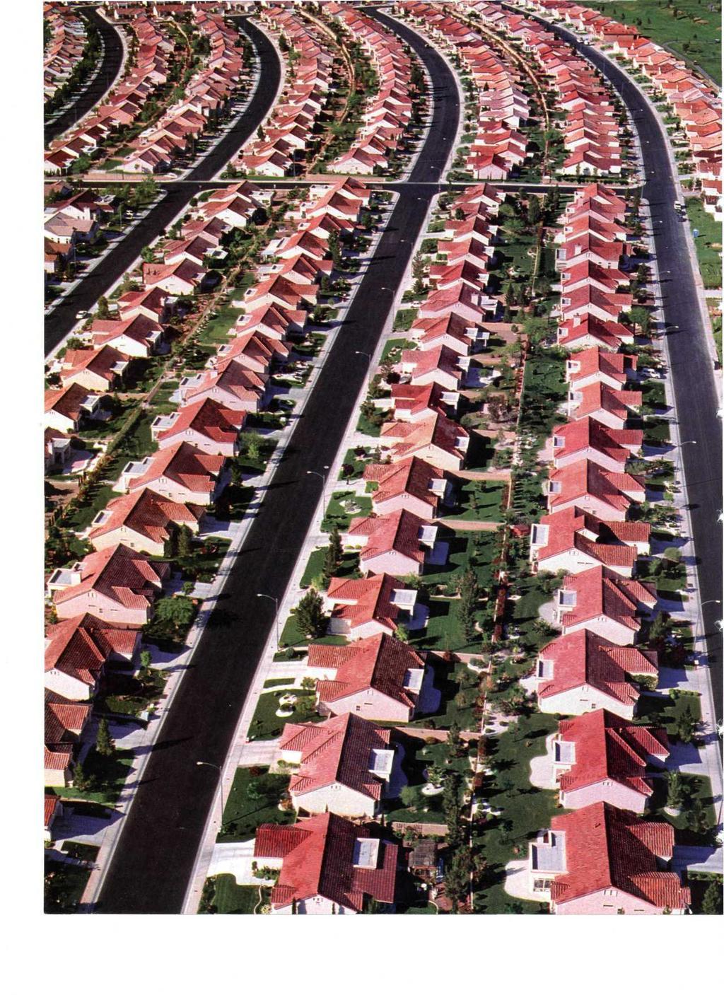
2 Urban Sprawl in North America: Where Will It End? CHAPTER Introduction Would you be surprised if you brought a picnic to a place called Hickory Woods, and there were no woods? Or if you took a drive to Partridge Farms, and there were no farms? What if you went for a walk through the Meadowlands and discovered that there were no meadows? You might be confused at first. Then you would see what these places had in common: houses lots and lots of houses. Hickory Woods, Partridge Farms, and the Meadowlands are all housing developments. Across North America, housing developments have been named after the types of land that were cleared in order to build new homes. For many decades, urban development in the United States and Canada has been moving out from cities to suburbs. A suburb is an area of housing built at the edge of a city. Developers create suburbs by buying up farmland or forested areas outside a city. They replace this open space with mile upon mile of housing tracts, shopping centers, and office parks. Often the only way to get from place to place in a suburban area is by car on traffic-clogged roads. The rapid and often poorly planned spread of cities and suburbs is known as urban sprawl. In this chapter, you will learn why urban sprawl happens. You will see how it affects people and the environment. And you will find out how people in three North American cities have dealt with it. How does urban sprawl affect people and the planet? Most cities begin as a small, compact urban core, as shown in the center ring of this diagram. As more people move to the city, development pushes outward to form an urban fringe. Beyond this is an area of rural, or open, land. This is called the rural fringe. Keep this diagram in mind as you try to answer the Essential Question. Housing development in Las Vegas, Nevada 79
3 5.2 The Geographic Setting "Welcome to LA!" say signs in the Los Angeles International Airport. Most people seeing these signs are visitors. They have come to Los Angeles for business or to see the sights. But some are people who have come to stay. The LA metropolitan area is growing by more than 200,000 new residents a year. A metropolitan area is a major city and its surrounding suburbs. Today 8 out of 10 people in the United States and Canada live in a metropolitan area. In the United States, New York City ranks first with more than 20 million people. In Canada, Toronto leads the way with more than 5 million residents. These two metropolitan areas have followed a similar pattern of growth. Stages of Urban Growth This diagram shows how a city becomes a sprawling metropolitan area. The old "walking city" lies at the center. Overtime, this urban core expands along rail lines and highways. The result is an urban fringe. Later growth pushes development out into the rural fringe. The Old Walking City: The Urban Core The oldest Canadian and American cities were founded during colonial times. At that time, cities had to be small enough for people to get around on foot or by horse. Homes and workplaces were in one small area. Today that old "walking city" is a city's urban core. People often think of this urban core as their city's "downtown" or business district. By the 1890s, many cities were bursting at their seams with people. Around that time, electric streetcars and commuter rail lines were developed. People began to build homes near these rail lines. They took trains or streetcars into the city center to work and shop. As a result, the urban core began to bulge outward along rail lines. Suburbs Around the City: The Urban Fringe By the 1920s, cars were becoming part of American life. No longer did city dwellers have to live near a rail line to get to their jobs. They could buy a car and commute. As cars became common, people began to build new housing areas farther away from the old urban core. In time, suburbs ringed most cities. These suburbs formed a new urban fringe. As people moved out of the urban core, some businesses moved out, too. The loss of people and businesses led to decay in older city neighborhoods. Meanwhile, people in the suburbs built their own town centers. These new communities were complete with shops, businesses, theaters, and parks. Where City Meets Country: The Rural Fringe Beyond the urban fringe lies an area with fewer people. Here, small towns mix with farms and open space. These less-developed areas form a rural fringe around a metropolitan area. This rural fringe is connected to the city by roads and highways. As populations grow, more and more of the rural fringe is developed. New homes, schools, shopping centers, and business parks seem to spring up almost overnight. Some people see this growth as a sign of progress. Others see it as harmful urban sprawl. In this chapter, you will explore both points of view. 80 Chapter 5

4 Geoterms metropolitan area a major population center made up of a large city and the smaller suburbs and towns that surround it rural fringe the small towns, farms, and open spaces that lie just beyond a city's suburbs suburb a developed area at the edge of a city that is mainly homes. Many suburbs also have stores and businesses. urban core the older part of a big city. Often the urban core serves as the downtown or central business district of a city. urban fringe the ring of small towns and suburbs that surround a big city urban sprawl the rapid, often poorly planned spread of development from an urban area outward into rural areas Urban Sprawl in Two Countries Metropolitan areas are found across the United States and Canada. Most people in both countries now live in cities and suburbs. As urban areas grow, they tend to sprawl outward. One dot equals 10,000 people. Urban Sprawl in North America: Where Will It End? 81

5 U.S. Farmland Converted to Developed Land, ;.?*wp I I Federally protected land «One dot equals 1,000 acres of converted land. 7,970,500 total acres converted from cropland to developed land, Urban Sprawl and Farmland Between 1982 and 1997, the United States lost almost 7 million acres of farmland to urban sprawl. This is an area about the size of Maryland. Only about a tenth of Earth's land is suitable for farming. If sprawl continues, will there be enough land left to feed Earth's growing population? 5.3 The Case for and Against Urban Growth Suppose a developer wants to build a housing development at the edge of a city. In many cities, a planning commission would need to approve the project. This body is made up of citizens chosen to guide a city's growth. The commissioners listen to people who support and oppose a project. Here are some of the arguments they might hear. Urban Growth Creates Needed Homes Everyone knows that when populations grow, new homes are needed. The question is where and at what cost to families. Those who favor growth argue that the best way to meet the need for housing is to develop empty land outside a city. Land in rural areas is cheaper than city land. Building costs in the country are lower than in the city. This keeps new homes affordable. In addition, many people want homes outside of cities. They believe that suburbs are better places than cities to raise a family. Pro-growth people say that urban growth has other benefits as well. New housing projects create jobs for construction workers. As people move into new homes, they spend money on things like furniture and garden supplies. All of this spending is good for local stores. The new homeowners also pay taxes. These taxes help fund roads, schools, and other city services. Urban Sprawl Damages the Environment Everyone agrees that people need housing, say those who oppose urban sprawl. The question is where and at what cost to the environment. 82 Chapter 5

6 These people argue that the worst way to meet the need for housing is to develop open spaces outside a city. Open spaces are not empty land. They are habitats for plants and animals. When land is developed, that habitat is lost and with it the wildlife that lived there. The National Wildlife Foundation warns that more than a thousand animal and plant species are in danger of dying out because of habitat loss to urban sprawl. Anti-sprawl people say that urban sprawl creates other problems as well. When housing is spread out, people rely on cars for transportation. This creates traffic jams and air pollution. Urban sprawl can also hurt people living in small towns. They often see their taxes go up when nearby land is developed. The extra tax money is needed to pay for roads, schools, and other services required when a small town suddenly grows. 5.4 Portland, Oregon, 1973 The Willamette Valley in Oregon is 120 miles long and 25 to 40 miles wide. The valley has Oregon's richest farmland. More than 170 crops are grown there. Orchards produce pears, plums, apples, and nuts. Fields of sweet corn and green beans mix with colorful flowerbeds and vineyards. The Willamette Valley is not all farmland, though. Oregon's largest city, Portland, is located at its northern edge. Growth Threatens the Willamette Valley Portland is known as the "City of Roses." Fragrant rose bushes fill its parks and gardens. Still, Portland is very much a big city. It has a downtown and many businesses. Its attractions include colleges, museums, and shopping areas. And, like all big cities, Portland has a lot of people. It was Portland's growing population that first began to worry people in the 1960s and 1970s. They feared that urban sprawl would soon gobble up the farms and forests of the Willamette Valley. A Difficult Decision: How Best to Grow? In 1973, Governor Tom McCall called on the state legislature to deal with this issue. "We are in dire need of a state land-use policy," McCall said. Oregon lawmakers agreed. But they weren't sure how best to control urban growth. There were many options the lawmakers might have considered. One might have been to allow growth to continue, but with a condition. For each acre of land that was developed, they would require that another acre be set aside to be preserved as open space. A second option might have been to create firm boundaries around cities. Once this was done, no new development would be allowed outside these boundaries. A third option was to ban all development in some rural areas, such as the Willamette Valley. Growth could be allowed in other areas that did not seem so valuable. Whatever lawmakers decided, one thing was clear. Their actions would affect the future of Oregon's people and its environment. Portland's Natural Setting The city of Portland lies at the north end of the Willamette Valley. In the distance you can see Mt. Hood. As Portland grew in the 1960s and 1970s, its urban fringe gave way to housing. People began to fear that the rest of the valley would soon be paved with homes and shopping malls. Urban Sprawl in North America: Where Will It End? 83

7 5.5 Portland Plans for Smart Growth In 1973, Oregon became the first state to create a set of land use planning laws. These laws promote an approach to land use planning known as smart growth. The basic idea of smart growth is to control sprawl by making better use of land that has already been developed. Urban Growth Boundaries Limit Sprawl Smart growth in Oregon began with a law creating urban growth boundaries. An urban growth boundary is a legal border. It separates urban land from rural land. New development is allowed inside the growth boundary. But it is not allowed on rural land outside the boundary. An urban growth boundary was drawn around the Portland metropolitan area. It included not only the city of Portland, but also several suburbs. To control growth inside this boundary, voters created a new regional government called Metro. Its main job is to plan growth inside the growth boundary. Smart Growth in Portland Portland is known for its smart growth policies. One of these policies calls for mixed-use developments like those shown here overlooking South Waterfront Park. Mixed use combines housing and business in one area. Getting Around on MAX Portland's light rail system is called the Metropolitan Area Express, or MAX. In 1986, MAX had 15 miles of track. By 2005, it had 44 miles of track. MAX connects downtown Portland to three suburbs and Portland's airport. Mixed Use Helps Portland to Grow Up, Not Out Oregon's land use planning laws have worked well. Today, Portland is a compact city with controlled growth. Its downtown area is friendly to pedestrians. It has hundreds of beautiful parks and open spaces. It also has a well-planned public transit system. Its buses and streetcars make it easy to get around without a car. These improvements have attracted many new residents to Portland. To provide housing for more people, the city is developing up, not out. Older, run-down neighborhoods have been revived with new mixed-use developments. This is development that combines housing and businesses in one area. For example, a building might have shops and offices on the ground floor and apartments above. Supporters of mixed-use development argue that it encourages people to live, work, and shop in one neighborhood. People can walk to jobs or shops instead of driving. This reduces traffic and air pollution. Opponents, however, argue that mixed-use development limits the kind of new homes that can be built. For people who want a big house on a large lot, a city apartment over a business is not their dream home. 84 Chapter 5

8 5.6 Toronto, Ontario, 1999 Toronto, Ontario, is Canada's largest metropolitan area. It is also its main business center. Toronto leads Canadian cities in printing and publishing. Television and movie production are important as well. With more than 5.5 million people, the city has been growing for decades. For a time, it managed this growth by stretching up. But Toronto soon began to sprawl out. Urban Sprawl in Toronto Toronto has been growing at a rapid pace for many years. By the late 1990s, urban sprawl stretched for miles and miles beyond the city limits. Building Up and Filling In Limits Sprawl Toronto has a long history. It began as a fur-trading post. In the 1800s, it became a factory town. Later still it developed into a banking center. But by the 1960s, its urban core was run down. Something had to be done to keep the downtown alive. In 1965, Toronto announced a plan to renew its urban core. The plan encouraged infill over sprawl. Infill involves filling in empty or ran-down parts of a city with new development. Building an apartment high-rise on an empty lot is an example of infill. So is building a shopping mall on the site of an old amusement park. During the 1960s and 1970s, Toronto rebuilt its urban core. The new buildings included some of the world's tallest skyscrapers. These towers had offices, shops, museums, parking, and housing. Rapid Growth on Toronto's Rural Fringe Toronto kept growing in the 1980s and 1990s. But instead of building up, it began to spread out. Urban sprawl took over farmland, forests, and wetlands. Traffic clogged suburban highways. Air pollution increased. Traffic and air quality both got worse as the years went by. By 1999, officials in Toronto knew they had to do something to control sprawl. There were many ideas they considered. One was to reduce sprawl by encouraging smart growth ideas like mixed-use development. Another idea was to ban all growth in rural areas. A third was to allow a lot of growth in part of the city while limiting it in the rest. Whatever was decided would shape Toronto's future. Urban Sprawl in North America: Where Will It End? 85

9 5.7 Toronto Plans for 30 Years of Growth On May 27, 2002, the mayor of Toronto gave a speech about urban growth. "Toronto is a great city, and we want it to stay that way," he said. "Where we go from here depends on all of us." He then introduced a document known as the Official Plan. It contained a plan for controlling Toronto's growth for the next 30 years. Future Land Use in Toronto Toronto's Official Plan includes a map showing how land is to be used in the city. This part of the map shows the downtown area bordering Lake Ontario. Development will be limited in neighborhoods marked in yellow and orange. Mixed use is encouraged in red areas. Parks and open space are shown in green. The brown areas near the waterfront are marked for redevelopment. Planning for Future Growth The Official Plan took three years to complete. The effort was led by Toronto's city council. The council heard ideas from people across the city. It also got advice from land use experts. The result was a plan that allows some growth in some places. The Official Plan allows growth to continue in 25 percent of the city. Most areas targeted for growth are in the urban core. They include the old downtown and the waterfront area on Lake Ontario. Growth is also allowed in four "centers" in outlying parts of the city. Public transportation is to be expanded to link these growth areas together. In the remaining 75 percent of the city, development is to be limited. This area includes the city's residential neighborhoods. It also includes waterways, parks, and open space. The Official Plan also lays out what kind of growth Toronto should encourage. New developments are to be mainly infill and mixed-use projects. Such projects will bring new homes, shops, and businesses into the urban core. Concerns About Infill Supporters of the Official Plan believe it offers a sensible approach to controlling sprawl. But while infill sounds like a good idea, not everyone supports it. Developers raise concerns about its hidden costs. Such costs include the extra time and money needed to clean up abandoned sites. This work must be done before new development can begin. If a site is polluted with toxic chemicals, these costs can rise very quickly. People living in neighborhoods marked for growth raise a different concern about infill. They worry that building new developments on empty lots will make the urban core more crowded. 86 Chapter 5
10 5.8 Atlanta, Georgia, 1998 In 1996, Atlanta, Georgia, hosted the summer Olympic Games. People came from around the world to watch the events. They filled hotels and restaurants. They cheered the athletes in new stadiums and arenas. Few visitors, however, traveled outside the city. Only those who did could see why Atlanta has been called "the fastest-spreading human settlement in history." Atlanta's Crowded Roads Traffic jams are a daily event in the Atlanta area. All of this driving creates major air pollution problems. In 1998, 13 counties in the Atlanta region failed to meet the Clean Air Act. A plan was needed to cut pollution in the entire metropolitan area. Rapid Growth Leads to Traffic Jams During the 1990s, the Atlanta metropolitan area boomed. Atlanta led the nation in new jobs, homes, and highways. It also led the nation in urban sprawl. Hundreds of acres of forest were cleared each week to make room for new residents. Without controls on development, housing tracts pushed deep into the rural fringe. The people who bought these new homes relied on cars to get around. Atlanta's commuters drove more miles every day than drivers anywhere else in the world. If you added up all the miles that Atlanta commuters drove in just one day, they would stretch all the way to the sun. There were traffic jams night and day. Air Pollution Threatens Highway Funds All those cars on Atlanta's roads also led to air pollution. The air became so polluted that it caused asthma attacks and other health problems. Atlanta's dirty air also violated the Clean Air Act. This is a federal, or national, law that sets limits on air pollution. In 1998, the federal government ordered Atlanta to meet the law's clean air standards. If it did not, Atlanta would lose federal highways funds. These are funds the federal government gives to cities to improve roads. Atlanta had to make a decision. One option was to do nothing to control growth. This would mean giving up federal highway funds. Another was to continue growing but to create a regional transportation system. Such a system could cut pollution by getting people out of their cars. A third option was to limit sprawl in some areas while requiring mixed-use development in others. Over time, this option could also reduce car trips and air pollution. Urban Sprawl in North America: Where Will It End? 87

11 5.9 Atlanta Fights Pollution with Public Transit In 1998, Roy Barnes was elected governor of Georgia. In his campaign, he promised to do something about the problems caused by sprawl. He made it clear, though, that he was not an enemy of development. "I'm no tree hugger," he said. "I'm a businessman who thinks you can't let your prosperity slip through your fingers." Rails and Trails in Atlanta Rather than slowing growth, Atlanta is trying to reduce air pollution with a better transit system. This map shows major rail lines. It also shows existing and future hiking and biking trails. As more people use rails and trails, traffic jams should decrease. A Regional Transportation Authority Is Born Governor Barnes wanted Atlanta to continue to grow. At the same time, he wanted to meet Clean Air Act standards. And so he focused on public transit. Under Barnes' leadership, the state created the Georgia Regional Transportation Authority. This agency had three goals: First, reduce traffic jams. Second, reduce air pollution caused by cars. Third, reduce poorly planned development. The Georgia Regional Transportation Authority works with other government agencies to get people out of their cars. One approach has been to promote mixed-use development. As you read, in mixeduse neighborhoods, people can walk to shops and jobs. Another has been to encourage people to walk or bike instead of drive. New bike trails and walking paths have been built. In addition, the region's public transit system had been expanded. The Metropolitan Atlanta Rapid Transit Authority (MARTA) is a system of trains and bus lines. It serves the entire Atlanta region. New rail lines have been built. A regional subway system has been expanded. New buses and bus routes have been added. The new buses don't pollute the air as much as older ones. Highway Existing trail Proposed trail Atlanta Continues to Grow The growth of public transit has helped Atlanta meet federal airquality standards. But it has not slowed growth. Urban sprawl remains a hot issue. Many people think the region should do more to control sprawl. Others say that Atlanta is doing just fine. They point out that there is new mixed-use development for those who want it. But they also think that people who want to buy new houses on the rural fringe should be allowed to do so. 88 Chapter 5

12 5.10 Beginning to Think Globally In this chapter, you learned about urban sprawl. You learned that cities grow outward. They expand from the urban core to the urban fringe to the rural fringe. You visited three metropolitan areas in the United States and Canada. And you saw how those areas are trying to deal with growth. Cities Continue to Sprawl The United States and Canada are still growing. As their populations increase, so does their need for housing. Even though sprawl isn't good for the environment, development continues to push into the rural fringe. As you have seen, there are many reasons why sprawl continues. Land and building costs are cheaper in the rural fringe than in the urban core. Some people prefer suburban homes to city apartments. Others don't like laws that limit where people could choose to live. Urban Sprawl in India Urban sprawl looks different in different parts of the world. In the urban fringe of Mumbai, India, new high rises have sprung up to house the wealthy. Nearby are shantytowns where poor people live. Sprawl Is a Worldwide Problem Cities around the world are struggling with urban sprawl. The Indian city of Mumbai (formerly known as Bombay) is a good example. In 1950, Mumbai had barely 3 million people. By 1995, the city had grown to more than 14 million. All those people could no longer fit into the old urban core. By 2015, Mumbai's population is expected to rise to 22 million. The only way it will be able to house so many people is by sprawling outward. Mumbai is not alone. Over the last century, the percentage of people living in urban areas has risen rapidly. In 1900, about 14 percent of people worldwide lived in cities. By 2000, almost 47 percent were in urban areas. That's nearly half of the world's people! Think about this as you look at the map of urban areas around the world in the next section. Urban Sprawl in North America: Where Will It End? 89

13 5.11 Global Connections This map shows metropolitan areas around the world. Cities with more than 5 million people are marked with large black dots. The bar graph shows how the populations of six cities have grown over time. Why might some regions have more metropolitan areas than others? Wealthy regions tend to have more large cities than poor ones. That's because most jobs in wealthy countries are found in cities. Climate, landf'orms, and vegetation zones also play a role. There aren't many big cities in extremely cold or arid regions. Nor are there many urban areas in mountains or rainforests. Urban Populations Around San Francisco Los Angeles PACIFIC OCEAN ATLANTIC OCEAN Why are there so many cities with more than 5 million people in Asia? The simple answer is this: Asia has more people than any other continent. More than 3 billion people live in Asia. Together, China and India are home to 4 out of 10 of the world's people. Also, the economies of many Asian countries are changing. They are shifting from farming to manufacturing and trade. Such economic activity generally takes place in urban settings. As a result, metropolitan areas are growing rapidly in Asia. What special problems might urban sprawl create for poor countries? Poor countries often have little control over how their cities grow. People moving to a city simply build homes wherever they find space. The governments of such countries lack money to provide growing cities with basic services. These services include clean water, paved roads, electricity, sewers, medical care, and schools. Over 5,000,000 people 1,000,000to 5,000,000 people 100,000 to 1,000,000 people Urban and Rural World Populations (estimated) 90 Chapter 5

14 Populations in Six World Cities Urban Sprawl in North America: Where Will It End? 91
The Old Walking City: The Urban Core
 Chapter 5: Urban Sprawl in North America Where Will it End? 1. Introduction Would you be surprised if you brought a picnic to a place called Hickory Woods, and there were no woods? Or if you took a drive
Portland was a beautiful city, but in the 1960s and 1970s, its population grew very fast.
 4 Portland, Oregon, 1973 After reading Section 4, identify three challenges facing Portland in 1973. Record them in the boxes below. Draw a line from each box to the part of the city most affected by that
10/19/2016. Chapter 22 Lecture Outline Urbanization. Urbanization and Sustainable Cities. Outline
 Chapter 22 Lecture Outline Urbanization 1 Urbanization and Sustainable Cities 2 Outline Urbanization Push and Pull Factors Urban Challenges in the Developing World Urban Challenges in the Developed World
Ch. 13 Urbanization. Global urbanizing trends 2/9/2016. Our urbanizing world. Central Case: Managing growth in Portland, Oregon
 Ch. 13 Urbanization Central Case: Managing growth in Portland, Oregon Oregon residents feared sprawling development would ruin their communities Urban Growth Boundaries (UGBs) allow development in urban
Chapter 13 Learning Guide Urban Patterns
 Chapter 13 Learning Guide Urban Patterns Key Issue 4 Why Do Suburbs Face Distinctive Challenges? Pgs. 424 434 Urban Expansion 1. What is annexation? Process of legally adding land area to a city 2. What
UNIT 2B URBAN AND RURAL CANADA: BUILDING SUSTAINABLE COMMUNITIES
 UNIT 2B URBAN AND RURAL CANADA: BUILDING SUSTAINABLE COMMUNITIES Part 1: Where Do Canadians live? The majority of Canadians live in cities. WHY? Because cities 1. Provide more services for people 2. Large
Chapter 22 Cities and Sustainability
 Chapter 22 Cities and Sustainability The city is not an ecological monstrosity. It is rather the place where both the problems and the opportunities of modern technological civilization are most potent
Making the Land Use, Transportation, Air Quality Connection
 Special Thanks To Our Generous Sponsor What Happened To Harbor Drive and the Mt. Hood Freeway? Andy Cotugno Metro Policy Advisor 180 days of air quality violations Gas Crisis Making The Pacific the Land
UNIT 5 URBAN AND RURAL CANADA: BUILDING SUSTAINABLE COMMUNITIES. Tuesday, 29 January, 13
 UNIT 5 URBAN AND RURAL CANADA: BUILDING SUSTAINABLE COMMUNITIES 1 Look at the photographs on p. 196 What do you see in each? In which of the above cities would you prefer to visit? Why? 2 Cities Provide
Wasatch CHOICE for 2040
 Wasatch CHOICE for 2040 Economic Opportunities We Can Choose a Better Future We enjoy an unparalleled quality of life along the Wasatch Front. People from all over the world are drawn to our stunning scenery,
Making the Land Use Light Rail Connection. Andy Cotugno Metro Rail~Volution 2010
 Making the Land Use Light Rail Connection Andy Cotugno Metro Rail~Volution 2010 Making The Pacific the Land Northwest Use, Transportation, The Oregon Story "There is a shameless threat to our environment
The Urban Environment: Creating Livable and Sustainable Cities
 13 The Urban Environment: Creating Livable and Sustainable Cities Chapter Objectives This chapter will help students: Describe the scale of urbanization Assess urban and suburban sprawl Outline city and
THE HISTORY OF PLANNING: PART II
 1 THE HISTORY OF PLANNING: PART II Dr. AbdulAziz Bubshait, Professor, Construction Engineering and Management Department. Introduction 2 The period between 1920 to the present has experienced enormous
English as a Second Language Podcast ESL Podcast 168 The Home Improvement Store
 GLOSSARY to need work has to be improved or made better * This house is big, but it is old and really needs work. to put off to delay, to wait * I ve been putting off washing the car and I think it s time
Birmingham. Summer study!!
 Birmingham Summer study!! Urban Change in the UK - Birmingham - Part 1 Location / Facts - Birmingham is located in the centre of England - It is the 2nd largest city with a population of around 1 million
Improve Neighborhood Design and Reduce Non Point Source Water Pollution
 HOW TO Planning Guide Improve Neighborhood Design and Reduce Non Point Source Water Pollution This document was funded by a grant from the New Hampshire Coastal Program with funding from the National Oceanic
The Urban Environment
 9 The Urban Environment Overview of Chapter 9 Population and Urbanization Characteristics of Urban Population Urbanization Trends City as an Ecosystem Environmental Problems in Urban Areas Environmental
CHAPTER 7: Transportation, Mobility and Circulation
 AGLE AREA COMMUNITY Plan CHAPTER 7 CHAPTER 7: Transportation, Mobility and Circulation Transportation, Mobility and Circulation The purpose of the Transportation, Mobility and Circulation Chapter is to
Green Guide to the Local Plan consultation
 Green Guide to the Local Plan consultation This guide is to help you fill in the Local Plan Have your say consultation. It doesn t tell you what to do, but gives some ideas for filling in answers and giving
Green Infrastructure The Indianapolis Greenways Connection
 Green Infrastructure The Indianapolis Greenways Connection Fewer things in the transportation industry today make better since than combining the needs for pedestrian and bike trails with the need to locate,
Reshaping The City: New Visions for Urban Transport. Trent Lethco, Associate Principal Allison Davis, Senior Planner Vicent Risica, Planner Arup
 Reshaping The City: New Visions for Urban Transport Trent Lethco, Associate Principal Allison Davis, Senior Planner Vicent Risica, Planner Arup Agenda Where are we now? Rethinking infrastructure? Cities
Coast Highway Oceanside, California
 Coast Highway Oceanside, California Coast Highway Plan Zones What We ve Heard - Walkable/Bikeable Community (Senior and Child Friendly) -Wider Sidewalks -Street Trees -Traffic Calming -Bike Lanes -Paseos
Peter Finley FRY. Land Use Planning & Design Consultant. Peter Finley Fry AICP. Portland, USA PORTLAND, OREGON STRATEGIES OF GROWTH MANAGEMENT
 23 26 JUNE 202 Peter Finley FRY Land Use Planning & Design Consultant Peter Finley Fry AICP Portland, USA PORTLAND, OREGON STRATEGIES OF GROWTH MANAGEMENT PORTLAND, OREGON STRATEGIES OF GROWTH MANAGEMENT
-'" 1. The snow eater happens in the. B White Mountains C Appalachian Mountains D Sierra Nevada Mountains
 _ A snow eater is a special wind. It blows only at certain places and times. One of these places is in the Rocky Mountains. The special time is most often late winter or early spring. The mountains are
Urbanization. R. Rosenberg Spring Urbanization- 1
 GLOBAL SYSTEMS Urbanization R. Rosenberg Spring 2018 Urbanization- 1 Where are we? * Environment * Economics * Engineered Systems o Energy o Water o Food o Urbanization o Internet Urbanization- 2 Our agenda
Mississauga remakes Lakeview s long-lost waterfront
 Mississauga remakes Lakeview s long-lost waterfront 26-hectare project will rebuild wetlands from the Toronto line to the site of the GTA s last coal-fired power plant. By: May Warren Staff Reporter, Published
Chapter 18. The Urban Environment: Creating Sustainable Cities. Lecture Presentations prepared by Reggie Cobb Nash Community College
 Chapter 18 The Urban Environment: Creating Sustainable Cities Lecture Presentations prepared by Reggie Cobb Nash Community College This lecture will help you understand: The scale of urbanization Urban
Sustainable Urban Planning:
 Sustainable Urban Planning: A More Energy Efficient Lifestyle with a Return to the Walkable City Elizabeth Monterrosa Energy Law Spring 2009 emonterrosa@kentlaw.edu Walkable City v. Urban Sprawl European
One said, without a clear understanding of what will be annexed, this is an exercise in futility.
 Stakeholder Focus Groups: Summary of Meetings Stakeholder Focus Group meetings were held on at the Pinellas County Planning Department conference room. Focus Group meetings will be held during each of
Design your Ideal City. Adrian A.-A.
 Design your Ideal City Adrian A.-A. My Vision I would love to create a city with a futuristic downtown with high rises and skyscrapers while staying environmentally friendly. As a coastal city on a large
Non-fiction: Waste Woes
 Waste Woes By Chris Jozefowicz Our old electronic gadgets often become toxic trash. School tests can be stressful. But they might also inspire you to help change the world. That s what happened to three
Lincoln Multi-Modal Center
 University of Nebraska - Lincoln DigitalCommons@University of Nebraska - Lincoln Theses from the Architecture Program Architecture Program May 2006 Lincoln Multi-Modal Center Jeffrey Bayer Follow this
Suwanee Design Charrette 2000 The City of Suwanee, Georgia is located in northeast Gwinnett County. In the 1990s Suwanee was one of the fastest growin
 Suwanee Design Charrette 2000 The City of Suwanee, Georgia is located in northeast Gwinnett County. In the 1990s Suwanee was one of the fastest growing small cities in Georgia, experiencing an over 260%
Press Backgrounder. About Sidewalk Toronto. Site
 Press Backgrounder About Sidewalk Toronto Sidewalk Toronto is a joint effort by Waterfront Toronto and Alphabet s Sidewalk Labs to design a new kind of mixed-use, complete community on Toronto s Eastern
Land Use Planning in the United States and in Oregon
 Land Use Planning in the United States and in Oregon Dr. Ethan Seltzer Nohad A. Toulan School of Urban Studies and Planning Portland State University Outline Planning in the United States Planning In Oregon
Fall www. aualum.org
 Fall 2007 www. aualum.org Photography by Jeff Etheridge Auburn Magazine For Alumni & Friends of Auburn University 33 34 Fall 2007 www. aualum.org Jean Williams recalls the day she was driving through her
LESSON MATERIALS. Group 1
 LESSON MATERIALS Group 1 explain the actions that Dunmore took and why he took them. Lord Dunmore, Governor of Virginia You are the Governor of Virginia, appointed by the King of England to rule the Virginia
ORANGE COUNTY IMPLEMENTING THE FOUR C s
 ORANGE COUNTY IMPLEMENTING THE FOUR C s East Central Florida Corridor Task Force O R A N G E COUN TY P LA N N I N G DIVISION C O M M U N I T Y, E N V I R O N M E N T A L A N D D E V E L O P M E N T S E
Willamette River Bridges HAER Spanning Willamette River at various locations, Portland Muitnomah County Oregon
 Willamette River Bridges HAER Spanning Willamette River at various locations, Portland Muitnomah County Oregon 08 REDUCED COPIES OF MEASURED DRAWINGS WRITTEN HISTORICAL AND DESCRIPTIVE DATA Historic American
Full Name /title*. Address 1. Address 2 Post Code* *.. Phone* *Required fields for draw
 You can return this later to post boxes at: the Parish Council Office, Rowney Green Village Hall, The Petrol Station at Hopwood, or the Library. Closing date 14 th March: Draw on 14 th April 2014 at Alvechurch
The Boomburb Downtown. Robert Lang, Ph.D. Arthur C. Nelson, Ph.D. FAICP Metropolitan Institute at Virginia Tech
 The Boomburb Downtown Robert Lang, Ph.D. Arthur C. Nelson, Ph.D. FAICP Metropolitan Institute at Virginia Tech Boomburbs Have over 100,000 residents and are mostly found in the Southwest U.S. Are not the
WELCOME. Welcome to this public exhibition about the future of the Aylesham Shopping Centre.
 WELCOME Welcome to this public exhibition about the future of the Aylesham Shopping Centre. This exhibition has been organised by Tiger Developments Ltd and members of the project team are available today
Chapter 1 Vision Statement & Goals
 Chapter 1 Section 1.1 Section 1.2 Section 1.3 Section 1.4 Section 1.5 Introduction Vision Statement Visioning Exercise Prioritization of Land Use Issues Goals of the Comprehensive Plan CHAPTER 1 SECTION
Foreword. Foreword. Sincerely, The Damascus Design Workshop: A Regional Model for a Clean, Green, Affordable and Fair UGB Expansion
 Foreword Foreword We are pleased to present this summary report of the results of the Damascus Community Design Workshop. This project represents a new effort by 1000 Friends of Oregon and the Coalition
Price Tags. Silver Spring. Washington on Rail 2. Issue 97 / November 7, 2007
 Price Tags Issue 97 / November 7, 2007 Silver Spring Washington on Rail 2 METROHOODS Price Tags 95 explored two Washington neighbourhoods: one shaped by the electric streetcar in the 1890s (Cleveland Park),
Transit Oriented Development. PB PlaceMaking Group RTD Planning & Development Committee May 4, 2010
 Transit Oriented Development Peer Agency State of the t th Practice GB Arrington PB PlaceMaking Group RTD Planning & Development Committee May 4, 2010 TOD State of the Practice Overview 1. How does RTD
CHAPTER 3 VISION, GOALS, & PLANNING PRINCIPLES. City of Greensburg Comprehensive Plan. Introduction. Vision Statement. Growth Management Goals.
 CHAPTER 3 VISION, GOALS, & PLANNING PRINCIPLES Introduction The Greensburg Comprehensive Plan is intended as a working community document. A combination of long and short-term goals, this document is intended
Activating the Urban Entertainment District: Signage in American Cities. YESTERDAY, TODAY, AND TOMORROW Activating the Urban Entertainment District 1
 Activating the Urban Entertainment District: Signage in American Cities YESTERDAY, TODAY, AND TOMORROW Activating the Urban Entertainment District 1 DAVID EHRLICH Executive Director, Urban Activation Institute
Growth Management Planning in the Central Puget Sound Region. Today s Presentation. Puget Sound Region. New Partners for Smart Growth
 Growth Management Planning in the Central Puget Sound Region New Partners for Smart Growth Denver, CO January 2006 Today s Presentation Regional growth management in central Puget Sound, WA Regional geographies
Understanding Text Structures
 Understanding Text Structures What is the first structure we will review? Sometimes, a writer will want to explain how one event leads to another This kind of text structure is called cause and effect
Summary of key points in support of LD 1553:
 Testimony of Stacy Mitchell Senior Researcher, Institute for Local Self-Reliance Before the Maine Legislature's Taxation Committee On LD 1553, An Act To Impose a Gross Receipts Tax on "Big Box" Stores
Case studies. B1.1 Lloyds Crossing, Portland (USA)
") B. Case Studies 57 B1 Case studies B1.1 Lloyds Crossing, Portland (USA) Lloyds Crossing in Portland is a brownfields redevelopment site in the central city area, with the aim of: Developing a conceptual
B. Case Studies 57 B1 Case studies B1.1 Lloyds Crossing, Portland (USA) Lloyds Crossing in Portland is a brownfields redevelopment site in the central city area, with the aim of: Developing a conceptual
Regional Context Statement
 Regional Context Statement REGIONAL CONTEXT STATEMENT 3. REGIONAL CONTEXT STATEMENT In 1995, the Provincial Government passed into law the Growth Strategies Act. The purpose of this provincial initiative
Economy Vision Statements: Social Wellbeing Vision Statements: Natural Environment Vision Statements:
 Economy Vision Statements: 1. Our business environment makes us a region of choice for new employers as we encourage entrepreneurship and have a vibrant, diversified and resilient regional economy. 2.
MONTCO 2040: A SHARED VISION The New Comprehensive Plan for Montgomery County. Dra Themes and Goals March, 2014
 MONTCO 2040: A SHARED VISION The New Comprehensive Plan for Montgomery County Dra Themes and Goals March, 2014 INTRODUCTION 2 WHAT IS A COMPREHENSIVE PLAN? A comprehensive plan is a long-range plan required
Nader Obied Abd al raheem hathat. Dr. Farid S. Al-Qeeq
 Submit from Nader Obied Abd al raheem hathat Submit to Dr. Farid S. Al-Qeeq DEC. 2010 NEW URBANISM : is the most important planning movement this century, which emerged during the late 1980s and early
Puget Sound A Great Region!
 Puget Sound A Great Region! Conservation is a state of harmony between man and nature. -Aldo Leopold Regional Problems Require Regional Solutions Keys to Regional Visioning Working Together Developers
495/MetroWest Development Compact Plan Citizen Planner Training Collaborative Conference. March 17, 2012
 495/MetroWest Development Compact Plan Citizen Planner Training Collaborative Conference March 17, 2012 Project Process Local and Regional Priority Areas Growth Scenarios Transportation Investment Categories
An illustration showing the use of Georgia-Pacific s products throughout the home. Courtesy of Georgia-Pacific.
 An illustration showing the use of Georgia-Pacific s products throughout the home. Courtesy of Georgia-Pacific. GEORGIA-PACIFIC A PROFILE IN GEORGIA S BUSINESS HISTORY Based in Atlanta, Georgia-Pacific
Create Streets We can help you make better places
 Create Streets We can help you make better places contact@createstreets.com www.createstreets.com Green wedges - are there alternatives to greenbelts? Mingfei Ma asks if there is a half-way house between
Windsor Locks Transit-Oriented Development Planning Grant Request. Project Background
 Windsor Locks Transit-Oriented Development Planning Grant Request Project Background Downtown Windsor Locks runs along Main Street in the vicinity of the intersection of Routes 159 and 140. The current
SWOT ANALYSIS Land Use
 Land Use S Village scale Rural character Hills/Mountain Current zoning Town plan Water Timber Prime agricultural land Public parks W High cost of land & farmland Route 7 bisects East Dorset Lack of funds
Benchmark Nonpoint Source Management Approaches In Other States
 Governor s Environmental Advisory Council 2007 Nonpoint Source Pollution Control Initiative Benchmark Nonpoint Source Management Approaches In Other States Governor s Environmental Advisory Council April
Case Study of Integrated Housing and Railway Development (Kohoku New Town and Yokohama City Metro Development)
") Case Study of Integrated Housing and Railway Development (Kohoku New Town and Yokohama City Metro Development) Project Division, Urban Development Bureau and Development Cooperation Division, International
Case Study of Integrated Housing and Railway Development (Kohoku New Town and Yokohama City Metro Development) Project Division, Urban Development Bureau and Development Cooperation Division, International
greenprint midtown SUSTAINABILITY ACTION PLAN 2012
 greenprint midtown SUSTAINABILITY ACTION PLAN 2012 MIDTOWN ALLIANCE SOUTHFACE ENERGY INSTITUTE RENAISSANCE PLANNING GROUP SUSTAINABLE ATLANTA PERKINS+WILL 2 GREENPRINT MIDTOWN 1. Introduction Sustainability
2. By 1971, most Canadians 76.1% - lived in towns and cities.
 1 S.S. 11: COUNTERPOINTS CH. 15: URBANIZATION NOTES INTRODUCTION 1. 1871 4 years after Confederation: For most men, life revolved around their jobs on farms, in lumber mills, at quarries, or in fishing
The Trust for Public Land. in Minnesota
 The Trust for Public Land in Minnesota Protecting Minnesota s Natural Legacy In Minnesota, The Trust for Public Land (TPL) is protecting strategic land and water resources for people to enjoy as parks,
CHAPTER 1: INTRODUCTION
 CHAPTER 1: INTRODUCTION MAP OF OUTAGAMIE COUNTY, WI N 1 = 6 miles INTRODUCTION The Town and Village of Black Creek are located in central Outagamie County, Wisconsin. The Village is located in the north
From i-waterfront to i-canada. The Role of Intelligent Communities in Canada's Digital Opportunity
 From i-waterfront to i-canada The Role of Intelligent Communities in Canada's Digital Opportunity 2015 Hutchison Management International Inc. All Rights Reserved April 29, 2015 From Automation to Smart/Intelligent
OREM CITY OREM UTOPIA SURVEY 2018
 OREM CITY OREM UTOPIA SURVEY 2018 1 Overall quality of life in Orem is high and residents are generally satisfied with the way the city is being run. However, compared to 2014 a somewhat smaller proportion
Transportation Working Team Duane Diggs, Co-Chair (VOICE Buffalo) Kelly Dixon, Co-Chair (GBNRTC) Paul Ray, Facilitator (UB Regional Institute)
 Kelly Dixon, Co-Chair (GBNRTC) Paul Ray, Facilitator (UB Regional Institute)") towards a more sustainable Buffalo Niagara Transportation Working Team Duane Diggs, Co-Chair (VOICE Buffalo) Kelly Dixon, Co-Chair (GBNRTC) Paul Ray, Facilitator (UB Regional Institute) Agenda Welcome,
towards a more sustainable Buffalo Niagara Transportation Working Team Duane Diggs, Co-Chair (VOICE Buffalo) Kelly Dixon, Co-Chair (GBNRTC) Paul Ray, Facilitator (UB Regional Institute) Agenda Welcome,
Errol Heights Park and Community Garden Frequently Asked Questions March 22, 2018
 Errol Heights Park and Community Garden Frequently Asked Questions March 22, 2018 Question 1: What improvements are planned for Errol Heights Park? How will the community be engaged in the process to shape
THE STILLWATER BRIDGE STORY
 THE STILLWATER BRIDGE STORY 1931 Stillwater Bridge Part I: The Backstory Behind the Bridge Undoubtedly the highest profile road project in Minnesota is the new bridge at Stillwater, the St. Croix Crossing.
Friday, March 4, 2011 New Brunswick, NJ
 Friday, March 4, 2011 New Brunswick, NJ Title Sponsors Smart Growth and Redevelopment Learn and Lead 1. Population is changing and redevelopment creates opportunities to meet the new demand Demographic
CHAPTER VI Plan Implementation
 Versailles-Midway CHAPTER VI Plan Implementation While prior sections focused on the tools the Commission needs to help it make the dayto-day decisions associated with subdivision, site plan and rezoning
Connecting Nine Buildings in Central Jakarta Together with the MRT. Mulyadi Janto, Director, PT Farpoint Prima
 Connecting Nine Buildings in Central Jakarta Together with the MRT Mulyadi Janto, Director, PT Farpoint Prima SEQUIS: INTER-SITE CONNECTIVITY 30/10/17 3.45pm 5.15 pm SEQUIS: INTER-SITE CONNECTIVITY 1.
PUT YOUR PASSION TO WORK
 PUT YOUR PASSION TO WORK SHARE THE EARTH. SHARE THE RESPONSIBILITY. EARTHSHARE.ORG You can protect the Earth we share. A glass of water, a breath of fresh air, a day outdoors with friends and family we
Building Smarter Cities. Building Smarter Cities 1
 SUSTAINABLE SYSTEMS Building Smarter Cities Building Smarter Cities 1 Today s topics The global trend toward urbanization Core urban systems Impact of rapid urbanization Sustainable ( smart ) cities Economic
What to do with all the old TVs, laptops and cellphones people throw away?
 What to do with all the old TVs, laptops and cellphones people throw away? By Orange County Register, adapted by Newsela staff on 01.14.14 Word Count 640 Old computer keyboards fill a box as EXPC employee
City Center Neighborhood Plan
 [1] City Center Neighborhood Plan As adopted by Ordinance No. 2014-09-049 and amended by Ordinance Nos. Formerly CBD Neighborhood as adopted by Ordinance No. 8868 and amended by Ordinance Nos. 8946, 9693,
Spatial Areas of Practice AICP EXAM REVIEW. February 20, 2009 Georgia Tech Student Center Gary A. Cornell, FAICP
 Spatial Areas of Practice AICP EXAM REVIEW February 20, 2009 Georgia Tech Student Center Gary A. Cornell, FAICP Acknowledgement Thanks to Mary M. Shaw, AICP Planning at the National Level Federalism in
Index 1-SETTLEMENT 2-RURAL SETTLEMENTS: (VILLAGES) 3-URBAN AREAS: (TOWNS) 3.1-TOWN FUNCTIONS 3.2-TOWN'S HIERARCHY 3.3-STRUCTURE OF TOWNS
 3-URBAN AREAS: (TOWNS) 3.1-TOWN FUNCTIONS 3.2-TOWN'S HIERARCHY 3.3-STRUCTURE OF TOWNS") TOWNS Index 1-SETTLEMENT 2-RURAL SETTLEMENTS: (VILLAGES) 3-URBAN AREAS: (TOWNS) 3.1-TOWN FUNCTIONS 3.2-TOWN'S HIERARCHY 3.3-STRUCTURE OF TOWNS 3.4-PARTS OF THE TOWN 4-URBAN PROBLEMS 5. EXERCISES 1-SETTLEMENT
TOWNS Index 1-SETTLEMENT 2-RURAL SETTLEMENTS: (VILLAGES) 3-URBAN AREAS: (TOWNS) 3.1-TOWN FUNCTIONS 3.2-TOWN'S HIERARCHY 3.3-STRUCTURE OF TOWNS 3.4-PARTS OF THE TOWN 4-URBAN PROBLEMS 5. EXERCISES 1-SETTLEMENT
Future City Class Project
 Future City Class Project Grade Class Name of School Date Note: This presentation may only be used for non-commercial, educational purposes. Any other use is strictly prohibited 2 City Planning Future
Regions are Growing...
 Growing Strong Communities: The rural version of smart growth New Partners for Smart Growth Conference 2006 Matthew Dalbey January 27, 2006 U.S. Environmental Protection Agency Development, Community and
MEGALOPOLIS: The Urbanized Northeast MEGALOPOLIS. Megalopolis at Night. Megalopolis: The Urbanized Northeast
 Megalopolis: The Urbanized Northeast Regional Landscapes of the United States and Canada MEGALOPOLIS: The Urbanized Northeast Prof. Anthony Grande AFG 2015 U.S. region stretching from Southern New England
By Chris Eckert, President, Sologic A version of this article appeared in the September 2010 issue of Pumps & Systems magazine.
 Slow Down and Think Casually to Solve Pump Problems Avoid repeat failures and lost production or profits by using a structured approach to problem solving. By Chris Eckert, President, Sologic A version
Telling the Oregon Story
 Telling the Oregon Story Our legacy, our future (Title) This presentation is intended as a brief, 20 minute INTRODUCTION to the value of good planning and provides a general background on Oregon s unique
Robbinsdale LRT Station. CDI Development Guidelines. August Overview
 Robbinsdale LRT Station August 2018 Overview The City of Robbinsdale may have the coolest opportunity site along the 13 mile stretch of the Bottineau LRT corridor / Blue Line extension. Located a block
Threat of Lawsuit Led To Watershed District
 Threat of Lawsuit Led To Watershed District (from Maine Townsman, June 2011) by Jeff Clark Sometimes, you need to pay attention to the gorilla in the closet. In 2007, the City of South Portland learned
Walkable Urban Places are Different & Complex to Manage
 Walkable Urban Places are Different & Complex to Manage Teaching a NASCAR Driver to be a Fighter Pilot Must Have a Strategy & Be Managed to Succeed, e.g., BID Each New Element Adds Value to Existing Assets
Reclaiming Old West Broad Street: I-16 Ramp Removal Study
 Reclaiming Old West Broad Street: I-16 Ramp Removal Study Community Meeting Summary July 15, 2014 The first community meeting for Phase II of the I-16 Ramp Removal Study was held on July 15, 2014, at the
Definitions. Average Daily Traffic Demand (ADT): The actual number or projected number of cars that pass a point in a 24-hour period.
: The actual number or projected number of cars that pass a point in a 24-hour period.") Definitions Access Management: A combination of physical techniques and transportation policies used to control the flow of traffic between roads and the surrounding lands. Alternative City Form Scenarios:
Definitions Access Management: A combination of physical techniques and transportation policies used to control the flow of traffic between roads and the surrounding lands. Alternative City Form Scenarios:
Envision Front Royal Workshop 1 of 2
 Envision Front Royal Workshop 1 of 2 September 12, 2013 Summary The Envision Front Royal project held the first of two public workshops on September 12, 2013. The purpose of the workshop was to evaluate
Sacramento Area Council of Governments (SACOG)
") Sacramento Area Council of Governments (SACOG) The Blueprint Vision The SACOG Board of Directors adopted the Preferred Blueprint Scenario in December 2004, a bold vision for growth that promotes compact,
Sacramento Area Council of Governments (SACOG) The Blueprint Vision The SACOG Board of Directors adopted the Preferred Blueprint Scenario in December 2004, a bold vision for growth that promotes compact,
Contemporary Urban Environments
 AQA Geography A-level Contemporary Urban Environments PMT Education Written by Jeevan Singh Contemporary Urban Environments Urbanisation Urbanisation is the growth in the proportion of a country living
REGIONAL ACTIVITY CENTER
 DRAFT REGIONAL ACTIVITY CENTER 70 EAST BENCH MASTER PLAN DRAFT 06 Introduction The East Bench Regional Activity center is comprised of large educational, research, medical, and employment centers. These
Elliot Park 2. Neighborhood Master Plan. Historical Perspective
 Elliot Park 2 Neighborhood Master Plan Historical Perspective August 2002 Early History Development patterns and the growth of Minneapolis largely grew out of the city s historical response to its geography.
epoint.edu.vn page 2 / 5
 IMPACT OF URBANIZATION ON FISH DIVERSITY COMPOSITION AND STRUCTURE OF STREAM FOOD WEBS ALONG A LAND COVER GRADIENT IN JEFFERSON COUNTY KENTUCKY CURRENT AND HISTORICAL PERSPECTIVES page 1 / 5 page 2 / 5
4 C OMMUNITY D ISTRICTS
 4 C OMMUNITY D ISTRICTS N ew development in the Area will include many different types of land uses, including a destination retail area that attracts people from all over the region; recreation opportunities
LAND PARK COMMUNITY PLAN
 LAND PARK Community Plan Part Three : COMMUNITY PLAN AREAS AND SPECIAL STUDY AREAS SACRAMENTO 2030 GENERAL PLAN Contents Community Location...3-LP-3 Community Vision...3-LP-4 Community Profile...3-LP-4