City of Sun Prairie Wetland Buffer Reduction Request
|
|
|
- Elfreda O’Connor’
- 6 years ago
- Views:
Transcription

1 City of Sun Prairie Wetland Buffer Reduction Request Westside Development Area January 9, 2017 Prepared by: City of Sun Prairie 300 E. Main Street Sun Prairie, WI 53590


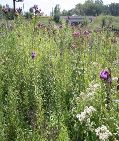
2 BACKGROUND The City of Sun Prairie is requesting relief from the 75-foot wetland buffer requirements as they pertain to a 15.5 acre farmed wetland complex located in areas recently annexed to the City in the vicinity of S. Grand Avenue and Blue Aster Boulevard. The subject wetlands have been farmed for decades, and as noted in a recent delineation report, are dominated by invasive plant species, specifically reed canary grass. Per the attached Stantec report regarding the Brooks Tractor Wetland Delineation, the wetland appears to meet the criteria for less susceptible wetlands with a required buffer per NR of 10 to 30 feet in width. The photos to the right are included in the Stantec report, and were taken while standing within the delineated wetland boundary. Based on information from the attached delineation reports, as well as a misunderstanding on the part of the City of the applicability of the buffer requirements in unmapped environmental corridors, development approvals have been granted by the City for some properties bordering the wetlands. Some grading activities have commenced on the properties in question in accordance with an NOI issued by the DNR for the project earlier this year. The wetlands are located on the four properties described and mapped below, three of which have received final development approvals from the City. The fourth property is in the process of being purchased by the City.
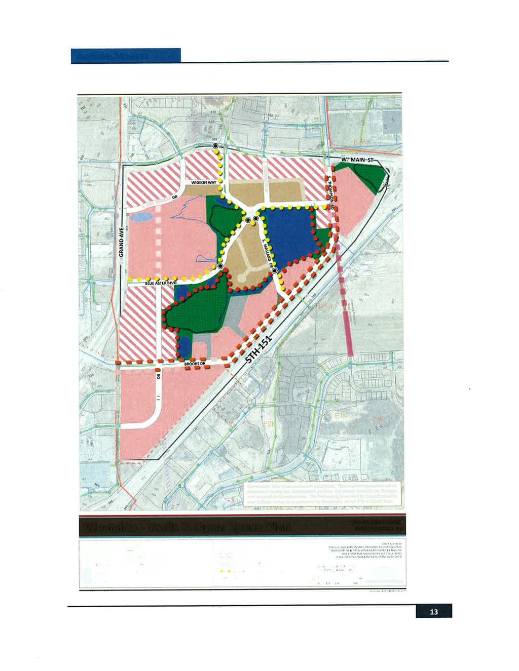
3 Site A - Menards: A 27.9-acre site located along the east side of Grand Avenue, between Blue Aster Boulevard and S. City Station Drive. In addition to the delineated wetlands, this site is also hindered by the presence of a natural gas pipeline within a 50-foot easement and an adjacent 10-foot utility easement, within which no structures may be located. Menard s proposed materials yard fence is allowed to cross the easement, but cannot run parallel with the pipeline within the easement. Site B Brooks Property: A 25.5-acre site located immediately south of the Menards property. Blue Aster Boulevard borders the site on the north, and Brooks Drive on the south. Zoning entitlements have been granted for a 228-unit apartment development on this site to be known as the Springs at Sun Prairie (Continental 345 Fund LLC). The same natural gas pipeline and utility easement extend through the Brooks Property, as well. Site C - West Prairie Village: Originally platted in 2005, the West Prairie Village plat was modified in 2016 to realign streets to better accommodate the pending development to the south. Site D - Schneider Property: The City of Sun Prairie is in the process of purchasing this 41+ acre site for the purpose of constructing a regional storm water facility on a portion of the property. The City plans to close on a portion of the property in March Although no final determination has been made at this time, it is likely that the balance of the property will be made available for development to help recover some of the acquisition costs. This property is included in this request due to the proximity of planned street connections to the wetlands, and because it is the only other undeveloped property that borders the subject wetland. WETLAND BUFFER REQUIREMENTS The Capital Area Regional Planning Commission (CARPC) enforces the following wetland buffer requirements regardless of the size or quality of wetlands involved: A 75-foot buffer around the perimeter of a wetland within which no impervious surfaces (buildings, roads, driveways, etc.) are permitted. A 30-foot no grading buffer around the perimeter of a wetland. The lands related to this request were included in the Sun Prairie Urban Service Area boundary by the Dane County Regional Planning Commission in its original delineation in No site-specific conditions of approval were included in the original delineation, and no environmental corridors were identified and mapped at that time. The City of Sun Prairie Municipal Code also contains a provision that requires a 75-foot buffer around delineated wetlands. However, the City s Planned Development District regulations provide a process for requesting the waiver or reduction of such zoning standards when deemed appropriate to provide flexibility that may be needed to address unique or challenging site conditions, to encourage more creative site planning, and to improve overall design quality. In the case of the developments described
4 herein, the justification for the buffer reductions granted by the City are described in the REQUESTED BUFFER REDUCTIONS section of this application. When City staff became aware of the need for CARPC and DNR approval of the buffer reductions, CARPC staff provided guidance as to the circumstances under which reduced wetland buffer widths might be considered. It was suggested that the following information be submitted in support of the petition: The petition for the wetland buffer reductions must be sponsored by the local governing authority. Attached please find City of Sun Prairie Ordinance #623 and Ordinance #647, approving the Planned Development General Development Plans for both the Menards and Brooks sites, respectively, within which the proposed buffer reductions were granted by the Sun Prairie Common Council. The Menards approval included the proposed street realignment in West Prairie Village (ie, Wigeon Way), which was designed in such a manner so as to allow the City to avoid direct encroachment into the wetlands when this street is extended in the future onto the Schneider Property (see the REQUESTED BUFFER REDUCTIONS section below for details). Due to current and past agricultural practices, the wetland in its current state provides little ecological or aesthetic value. To help account for the reduced buffer, a wetland restoration plan has been developed to improve the quality of this resource, a acre wetland in a rapidly developing urban area. Further information regarding implementation of the restoration plan is provided under the WETLAND RESTORATION PLAN section of this application. NR 151 post-construction standards allow for some direct runoff to wetlands when other areas are over-treated and overall 80% TSS control is achieved. Post-construction stormwater management measures are planned to minimize direct impacts on the wetlands by providing pre-treatment of runoff within on-site storm water facilities prior to runoff entering the wetlands. A summary of these efforts is provided in the POST CONSTRUCTION STORM WATER MANAGEMENT PLAN section of this application. Construction site erosion control measures will also be implemented to account for grading within the 30 foot buffer. A summary of such erosion control measures is provided in the CONSTRUCTION SITE EROSION CONTROL PLAN section of this application. REQUESTED BUFFER REDUCTIONS The specific buffer reductions being requested and the proposed justification for granting the requested relief from the buffer requirements follow: Menards Property: The Menards development plan evolved over an extended period. The initial concept plan for the facility involved a smaller site that did not have access to the proposed extension of Blue Aster Boulevard, and would have resulted in a petition to the DNR to fill approximately 2.3 acres of the wetland in order to create a building site large enough for the store (see September 2014 Concept


5 Plan, right). At that time, City staff recommended that the concept plan be rejected, in part due to the wetland encroachment. However, as a result of public feedback received through a subsequent plan amendment process for this area of the City, the Plan Commission and City Council approved a plan that shifted the commercial site to the south to avoid the wetlands and to gain access to the signalized intersection at Grand Avenue and Blue Aster Boulevard. Upon approval of the Plan amendment, Menards negotiated the purchase of additional land to the south to comply with the intent of the City s action. In addition to the wetlands, development of the Menards site is further challenged by the presence of a natural gas pipeline that runs north-south through the easterly 1/3 rd of the property. No structures are allowed within the easement, and while the fencing that encloses the proposed materials yard may cross the easement, it may not run lengthwise within the easement parallel to the pipeline. The combination of wetlands and the restrictions within the easement create a challenging site that is difficult to design within, and the imposition of the full 75 buffer complicates the site even further. In considering the proposed buffer reduction as part of the Planned Development process, the City took into account Menard s willingness to adjust its plans to avoid the filling of the wetland as originally proposed, the complications created by the pipeline easement and its associated restrictions, the overall poor quality of the farmed wetlands, and the proposed storm water plan, which diverts water to several on-site detention and treatment facilities before being released back into the

6 natural drainage system in the area. As proposed, a 30-foot no-build buffer is maintained in all but one location on the property, with associated grading proposed within the remaining 30-foot buffer. In one location the materials enclosure comes within approximately 6 feet of the wetland boundary in one location where the wetland extends very close to the pipeline easement. Brooks Property: The Brooks property was recently annexed into the City and approved for a 228-unit apartment development. It is being developed by Continental 345 Fund LLC. The wetland occupies a substantial portion of this property, and the gas pipeline and easement also runs through this site. The Continental plan works around the wetland, but involves some development within the 75-foot buffer and grading within the 30-foot buffer (all proposed impervious surface other than a planned multi-purpose path would be located at least 30 feet from the wetland). To comply with recommendations of the City s Land Use Plan and Official Map, the development includes a north-south street through the property that connects from Brooks Drive on the south to Blue Aster Boulevard on the north. The alignment of this street is dictated on both the south and the north by prior decisions. At Brooks Drive to the south, the roadway lines up with a right of way purchased and platted by the Wisconsin Department of Transportation in the early 2000s as part of the Hwy 151/CTH C interchange project. At Blue Aster, the street is to line up with the approved entrance to the Menards property. This alignment dictates that the street be located near the edge of the wetland, but a 30-foot setback between the wetland and the edge of the right of way has been maintained. Grading for this roadway is proposed within the 30-foot buffer. The development includes a proposed multi-purpose path along the edge of the wetlands in response to the City s adopted land use plan and Official Map, which call for the development of a trail network around the wetland and storm water features in this vicinity as a means of providing recreational opportunities for residents in the area. Installation of the trail contributes to the extent of the grading that is proposed within the 30-foot no grading buffer. As with the Menards development, the City Council approved a reduction in the buffer as part of the Planned Development General Development Plan for this property, as noted on the Ordinance attached to this application. The quality of the wetland, the challenges presented by the location of the pipeline
7 and easement on the property, and the desire to encourage a moderate density development on this site, which is within walking distance of several nearby retail businesses, entertainment venues and offices, provided the justification for the buffer reductions. West Prairie Village Plat: The West Prairie Village First Addition plat was recorded in 2005, but the streets south of W. Main Street have not yet been developed. In order to better connect with the Menards development and facilitate access from Menards to W. Main Street, the developers of West Prairie Village agreed to the replatting of this portion of their development to realign the streets, including the realignment of Wigeon Way. In agreeing to do so, West Prairie Village LLC was concerned about the creation of unusable parcels to the south of Wigeon Way, and requested that Wigeon be moved to the south to maintain as much developable land as possible within their plat. Initially, the realigned Wigeon Way was to be located outside of the 30-foot no grading buffer. However, as part of these discussions the City was also able to negotiate the adjustment of the right of way of the north-south aligned S. Mallard Drive, which is planned to run generally parallel to the east side of the wetlands, with a multi-purpose path along its west edge to offer public access and enjoyment of the wetlands. This right of way was shifted to the east so that as it extends into the Schneider property in the future it can avoid disturbance of the wetlands that have recently been delineated. Unfortunately, in doing so this also required the adjustment of Wigeon Way, which shifted closer to the wetland in order to square up the intersection of Wigeon and S. Mallard. As a result, Wigeon Way is now platted within the 30-foot no grading buffer. Given the circumstances and the fact that this adjustment was done to help avoid the need to fill wetlands in the future as the street system is extended, the City felt that this was a good compromise and approved the reduction in the buffer in this area. We are requesting similar action from CARPC and the DNR. Initial realignment of Wigeon Way. Final realignment of Wigeon Way.


8 Schneider Property: As mentioned earlier, the City is in the process of purchasing the Schneider Property in order to use a portion of the site for a regional storm water management facility. This facility will likely be located on the eastern 1/3 rd of the property, and the balance of the land will likely be sold for development to recover some of the acquisition costs. As such, there is no current development plan for the lands located adjacent to the wetlands other than the City s future land use plan. As noted above, as Mallard Drive is extended south into the Schneider Property, the City s aim is to avoid disturbance of the wetland recently discovered in this vicinity. The shift in the right of way should provide enough room to avoid impacts on the wetland, but the street and associated grading will very likely be within the 75-foot buffer. Grading activities will likely be located within the 30-foot buffer, as well. For the balance of S. Mallard Drive, the City would like to have the flexibility to locate all or portions of S. Mallard within the 75-foot buffer, provided that all associated grading remains outside of the 30-foot no grading buffer and stormwater generated from the future road will be treated prior to drainage to the wetland. One goal in this vicinity is to locate a multi-purpose path along the west side of Mallard Drive near the wetlands to provide access to this area for the public.
9 WETLAND RESTORATION PLAN In association with the pending development projects, the improvement of the existing 15.5 acres of farmed wetlands is being proposed to offset the requested reductions in the wetland buffers. A summary of the buffer treatments and planned wetland enhancement is provided on the attached restoration plan, and involves the reseeding of the buffers and wetland with a range of native vegetation (wet detention seed mix, native mesic prairie seed mix, and wet mesic prairie seed mix). In addition, wetland buffers will be seeded with a no mow seed mix to help stabilize these areas and prevent erosion. In conjunction with the Menards and Continental construction plans, each developer will be responsible for implementing the wetland restoration plan on their perspective property as indicated. A three-year maintenance plan will be established and enforced to ensure that weeds are controlled, woody species are removed, and native plantings are provided the opportunity to flourish and take hold. Activities will include, but may not be limited to, maintenance mowing or spot mowing once or twice annually to a minimum height of 6-12 inches until the native plantings are adequately established. POST CONSTRUCTION STORMWATER MANAGEMENT PLAN Post-construction stormwater management measures have been proposed for the Menards development (which includes the West Prairie Village street network) as well as the Brooks Property (Continental 345 Fund LLC). These developments have submitted Stormwater Management Plans to conform to Chapter of the Sun Prairie s Stormwater Management Ordinance and Chapter 14 of the Dane County Manure Management, Erosion Control and Stormwater Management Ordinance. In addition to the County Ordinance for peak runoff control, the City of Sun Prairie also requires that the proposed development limit the peak runoff rate for the 10 year through the 25 year events to the 5 year predevelopment runoff rate. Menards: A wet detention pond is proposed on the north side of the site, separated by an access road but connected with an equalizer pipe. This pond will handle runoff from portions of City Station Drive, Wigeon Way and the majority of the Menards parking lot. An infiltration basin on the east side of the site will handle runoff from the Menards building, warehouse and the outdoor yard area. A third pond will be constructed on the south side of the Menards site and will handle runoff from the nearby road to the south and the future development of Lot 2 and Blue Aster Boulevard. In addition to treating the Menards site, developer is also treating approximately 3 acres from Grand Avenue that drained to the wetland network pre-development, further improving the water quality entering the wetlands. Continental: Two wet detention ponds are proposed for water quality treatment. The first basin is located in the northeast corner of the property that treats buildings, parking lots and a portion of the proposed Spring Street. The second basin is centrally located on the opposite side of Spring Street from the wetland. This facility handles the majority of runoff from development on the west side of Spring Street.
10 As it pertains to the wetlands, the individual stormwater management plans result in improving the water quality before it enters the wetlands. The pre-development conditions included farmed cropland and portions of Grand Avenue stormwater draining to the farmed wetlands. Combined with the wetland restoration plan, the development stormwater facilities will provide improved water quality, enhanced groundwater recharge and improved aesthetics with improved accessibility to create a valuable public recreation feature out of the existing wetlands. City Staff, along with MSA Professional Services, the City s consulting engineer, continues to review and comment on Menard s and Continental s stormwater management plans. Both current stormwater management plans are included in the attach materials. MSA s status of review memo, which also includes responses to Tony Vandermuss review comments, is also included. CONSTRUCTION SITE EROSION CONTROL PLAN Prior to any land disturbance or grading that is related to development outside the wetlands, construction site erosion control measures will be implemented. Anticipated measures will include the following: 1. Silt fence (WDNR Conservation Practice Standard 1056) will be placed around the perimeter of the entire delineated wetland. Silt fence will also be implemented at perimeter locations of the site where sheet flow drainage has the potential to transport sediment offsite. 2. Temporary sediment traps (WDNR Conservation Practice Standard 1063) will be constructed at the same locations where bioretention basins are sited. Following 85 percent build out of the subdivision, the temporary sediment basins will be removed and replaced with the bioretention basins. 3. Minimum no grading vegetative buffers of 5 to 30 feet or more will be maintained around the perimeter of the wetlands, with the exception of the small area on the Menards site where the wetland is only 6 feet from the pipeline easement. The buffer areas will be seeded with a no mow fescue seed mix. 4. Install stone tracking pads (WDNR Conservation Practice Standard 1057) at all points of construction traffic egress. 5. Implement Class II, Type C organic erosion control revegetative mat on all side slopes greater than 4:1. This type of mat is typically used adjacent to environmentally and biologically sensitive areas where plastic netting is inappropriate and will generally last three-years or greater also. As final design of each development is advanced, detailed Construction Site Erosion Control Plans will be developed and submitted for review and approval.
11
12
13


14 Wetland Restoration Seed Mix Examples No Mow Seed Mix Wet Detention Seed Mix Native Mesic Prairie Seed Mix Wet Mesic Prairie Seed Mix
15 W. Main St Site C S. Grand Avenue Site A Wigeon Way Site D Blue Aster Blvd Gas Pipeline Easement Site B Brooks Drive
16

17
SUPPORTING DOCUMENT STORMWATER POLLUTION PREVENTION PLAN (SWPPP) NARRATIVE
 NARRATIVE") SUPPORTING DOCUMENT STORMWATER POLLUTION PREVENTION PLAN (SWPPP) NARRATIVE Please complete this narrative form and submit with your SWPPP drawings. Refer to Kitsap County Stormwater Design Manual Vol.
SUPPORTING DOCUMENT STORMWATER POLLUTION PREVENTION PLAN (SWPPP) NARRATIVE Please complete this narrative form and submit with your SWPPP drawings. Refer to Kitsap County Stormwater Design Manual Vol.
Project Applicant Checklist for NPDES Permit Requirements SAN MATEO COUNTYWIDE STORMWATER POLLUTION PREVENTION PROGRAM
 Project Applicant Checklist for NPDES Permit Requirements SAN MATEO COUNTYWIDE STORMWATER POLLUTION PREVENTION PROGRAM I. PROJECT DATA Project Name Bay Meadows Development Phase II Project Address 2600
USA Addition of South & East Side Residential Parcels. USA Deletion of a Town of Christiana Parcel. Conversion from USA to Limited Service Area
 Village of Rockdale Village of Rockdale 148 Water Street Cambridge, WI 53523 Phone 608.423.1497 Fax 608.423.9694 Urban Service Area (USA) Amendment USA Addition of South & East Side Residential Parcels
Florence County Small Commercial Land Disturbance Permit Application
 Florence County Small Commercial Land Disturbance Permit Application Florence County Engineering Division 518 South Irby Street Florence, S.C. 29501 Phone (843) 676-8600 Fax (843) 676-8667 Tax Map Number:
DRAFT DESIGN CRITERIA STORMWATER TREATMENT STANDARDS CITY OF OVERLAND PARK
 DRAFT DESIGN CRITERIA STORMWATER TREATMENT STANDARDS CITY OF OVERLAND PARK A. Authority As set forth in the Overland Park Municipal Code (OPMC), Chapter 16.210, the Director of Planning and Development
Zoning Ordinance Chapter 10
 CHAPTER 10 - WASHES SECTION 10.0 GENERAL: A. The purpose of this Ordinance is to establish standards for development in or near Major and Minor Washes as defined in Appendix A Glossary of Terms and Definitions
Draft Rhode Island Stormwater Design and Installation Standards Manual
 Draft Rhode Island Stormwater Design and Installation Standards Manual Summary The May 2009 Public Review Draft version of the RI Stormwater Design and Installation Standards Manual consists of approximately
City of Stoughton Erosion Control Permit Application (effective 2/6/2018)
") City of Stoughton Erosion Control Permit Application (effective 2/6/2018) Incomplete applications will not be accepted Project Name: Address of subject property: Landowner Name(s): Applicant Name: Landowner
City of Stoughton Erosion Control Permit Application (effective 2/6/2018) Incomplete applications will not be accepted Project Name: Address of subject property: Landowner Name(s): Applicant Name: Landowner
Asbury Chapel Subdivision Sketch Plan
 Asbury Chapel Subdivision Sketch Plan PART 1: PROJECT SUMMARY Applicant: NVR Inc. Project Size: +/- 76.13 acres Parcel Numbers: 02101112,02116101,02116112, 02116113 Current Zoning: Transitional Residential
WQ-23 MOUNTAINOUS AND STEEP SLOPE SITES
 Greenville County Technical Specification for: WQ-23 MOUNTAINOUS AND STEEP SLOPE SITES 1.0 Mountainous and Steep Slope Sites 1.1 Description The geographic locations of portions of Greenville County are
Gold Line Bus Rapid Transit Transit Oriented Development (BRTOD) Helmo Station Area Plan
 Helmo Station Area Plan") Appendix F Gold Line Bus Rapid Transit Transit Oriented Development (BRTOD) Helmo Station Area Plan Introduction and Purpose of the Plan The Gold Line Bus Rapid Transit facility is an eleven-mile dedicated
Appendix F Gold Line Bus Rapid Transit Transit Oriented Development (BRTOD) Helmo Station Area Plan Introduction and Purpose of the Plan The Gold Line Bus Rapid Transit facility is an eleven-mile dedicated
Plan Review Checklist
 Plan Review Checklist FOR EROSION AND SEDIMENT CONTROL PLANS _ Minimum Standards - All applicable Minimum Standards must be addressed. All minimum Standards must be adhered to during the entire project
The Engineer/Developer s Perspective on Storm Water Management
 The Engineer/Developer s Perspective on Storm Water Management CASE STUDY: An Innovative Approach to Storm Water Management for Small Parcel Site Development Presented by: James B. Leedom, P.E. The Sigma
The Illinois Department of Transportation and Lake County Division of Transportation. Route 173, including the Millburn Bypass
 The Illinois Department of Transportation and Lake County Division of Transportation welcome you to this Public Hearing for U.S. Route 45 from Illinois Route 132 to Illinois Route 173, including the Millburn
SITE PLAN REVIEW APPLICATION AND CHECKLIST
 SITE PLAN REVIEW APPLICATION AND CHECKLIST PROJECT SUMMARY: Project Name: City/ETA Location: City ETA (Application fee & number of copies needed are based on location) Property Location (Legal Description
CITY PLANNING COMMISSION AGENDA ITEM: C STAFF: ROBERT TEGLER FILE NO: CPC PUD QUASI-JUDICIAL
 CPC AGENDA June 8, 2006 Page 37 CITY PLANNING COMMISSION AGENDA ITEM: C STAFF: ROBERT TEGLER FILE NO: CPC PUD 05-294 - QUASI-JUDICIAL PROJECT: APPLICANT: OWNER: PARKWOOD AT WOLF RANCH NASS DESIGN ASSOCIATES
Village of Glenview Plan Commission
 Village of Glenview Plan Commission STAFF REPORT January 22, 2019 TO: Chairman and Plan Commissioners CASE #: P2018-047 FROM: Community Development Department CASE MANAGER: Tony Repp, Senior Planner SUBJECT:
Watertown City Council
 City of Watertown Watertown City Council April 14 th, 2015 Agenda Item: City Comment on Sun Share CUP Application Request for Action: Motion to Approve City Comments regarding CUP Application Department:
Town of Essex Small Site Erosion Control Guide
 Town of Essex Small Site Erosion Control Guide Why do we need to protect against erosion? Water Quality: Erosion and the transport of sediment and pollutants impacts the water quality of nearby streams
A. INTRODUCTION AND SUMMARY OF FINDINGS B. EXISTING CONDITIONS. Table 10-1 Adjacent Storm Drains
 Chapter 10: Stormwater Management A. INTRODUCTION AND SUMMARY OF FINDINGS This chapter describes existing and proposed stormwater management on the Site. Potential impacts to stormwater infrastructure
City of Yelm. Tahoma Terra Final Master Plan Development Guidelines. Table of Contents
 City of Yelm Tahoma Terra Final Master Plan Development Guidelines Table of Contents Table of Contents... 1 Purpose... 2 Low Density Residential (R4-6)... 3 Moderate Density Residential (R6-10)... 5 Neighborhood
CITY OF TUMWATER 555 ISRAEL RD. SW, TUMWATER, WA (360) (360) (FAX)
 (360) (FAX)") CITY OF TUMWATER 555 ISRAEL RD. SW, TUMWATER, WA 98501 (360) 754-4180 (360) 754-4126 (FAX) Email: cdd@ci.tumwater.wa.us APPENDIX II-C SHORT FORM CONSTRUCTION STORMWATER POLLUTION PREVENTION PLAN (SWPPP)
CITY OF TUMWATER 555 ISRAEL RD. SW, TUMWATER, WA 98501 (360) 754-4180 (360) 754-4126 (FAX) Email: cdd@ci.tumwater.wa.us APPENDIX II-C SHORT FORM CONSTRUCTION STORMWATER POLLUTION PREVENTION PLAN (SWPPP)
REQUEST FOR COUNCIL ACTION 6A AGENDA ITEM
 DATE REQUEST FOR COUNCIL ACTION 6A AGENDA ITEM ORIGINATING DEPT. AGENDA ITEM CITY ADMINISTRATOR APPROVAL Community Development PUD Concept & Development Stage Plan Preliminary Plat & Final Plat PREVIOUS
Chapter 1: General Program Information
 Chapter 1: General Program Information 1.1 Introduction The Montgomery County Stormwater Management Resolution (#03-1-5) was adopted by the County Board of Commissioners on January 22, 2003. The purpose
Major Subdivision Sketch Plan Checklist
 This checklist provides specific requirements that are apart of the Sketch process. The entire process is described by the Huntersville Subdivision Review Process which details all the submittal and resubmittal
S o u t h C e n t r a l O u t l i n e P l a n. Leduc Business Park. North Leduc Industrial Area Structure Plan C it y of Led u c.
 Leduc Business Park North Leduc Industrial Area Structure Plan C it y of Led u c Prepared for Farm Air Properties Inc. January, 2007 Table of Contents Page Number 1.0 Purpose of Plan and Definition of
Section 3 Non-Structural BMPs
 3.1 Stream Buffers A stream buffer or stream setback is a designated area around a stream, lake, or wetland left in a natural, densely vegetated state so as to protect the receiving water quality and provide
STORMWATER MANAGEMENT CODES ANALYSIS RICHLAND COUNTY, SC SITE PLANNING ROUNDTABLE
 STORMWATER MANAGEMENT CODES ANALYSIS RICHLAND COUNTY, SC SITE PLANNING ROUNDTABLE Codes analyses for each subcommittee were completed to assist participants of the Richland County Site Planning Roundtable.
 Stormwater Management Plan Narrative Quality Fleet Services, Inc. SITE RE-DEVELOPMENT 548 New Ludlow Road South Hadley, MA The project proposed by Quality Fleet Services, Inc. consists of the site improvements
PRELIMINARY STAFF PLANNING REPORT TO THE WALWORTH COUNTY ZONING AGENCY X CONDITIONAL USE
 This report was prepared prior to the public hearing. This report may be supplemented or amended to reflect the review of additional information presented at the public hearing and written material submitted
Review Zone Application for D&R Canal Commission Decision
 Review Zone Application for D&R Canal Commission Decision MEETING DATE: July 20, 2016 DRCC #: 16-4803 Latest Submission Received: June 13, 2016 Applicant: Robert McCarthy, PE PSE&G 4000 Hadley Road, 2
SECTION II SECTION II STATEMENT OF GOALS, OBJECTIVES, PRINCIPLES, ASSUMPTIONS, POLICIES AND STANDARDS
 STATEMENT OF GOALS, OBJECTIVES, PRINCIPLES, ASSUMPTIONS, POLICIES AND STANDARDS 1 2 STATEMENT OF GOALS, OBJECTIVES, PRINCIPLES, ASSUMPTIONS, POLICIES AND STANDARDS INTRODUCTION The New Jersey Municipal
Soil Erosion & Sediment Control Plan Requirements for Submittal to the Cape Atlantic Conservation District
 Soil Erosion & Sediment Control Plan Requirements for Submittal to the Cape Atlantic Conservation District The following is a list of the minimum requirements required on Soil Erosion and Sediment Control
Chapter 3 Site Planning and Low Impact Development
 CHAPTER 3 Site Planning and Low Impact Development Chapter 3 Site Planning and Low Impact Development 3.0 Introduction The City of Charleston requires that major residential, large commercial (>1 acre),
12/7/2007. Christopher B. Burke Engineering West, Ltd Aux Sable Creek Watershed Plan Update 1
 The ABC s of BMP s Aux Sable Watershed Plan St. Charles, IL Why are BMP s Important Best Management Practices (BMPs) developed as a set of practices which help to achieve goals of the Clean Water Act and
City of Grande Prairie Development Services Department KENNEDY DEVELOPMENTS LTD. OUTLINE PLAN OP-09-01
 City of Grande Prairie Development Services Department KENNEDY DEVELOPMENTS LTD. OUTLINE PLAN OP-09-01 July 27, 2009 TABLE OF CONTENTS 1.0 Introduction... 1 1.1 Plan Area Location & Context... 1 1.2 Ownership
SENSITIVE LANDS OVERLAY
 SENSITIVE LANDS OVERLAY Chapter 22 Sensitive Lands Overlay 22.1 PURPOSE 22.2 APPLICATION AND ANALYSIS REQUIREMENTS 22.3 SENSITIVE LAND REGULATIONS 22.4 ADMINISTRATIVE PROVISIONS 22.5 DESIGN STANDARDS 22.6
UNIVERSITY OF MICHIGAN:
 Chapter Eight UNIVERSITY OF MICHIGAN: North Campus I. Introduction The University of Michigan currently owns approximately 800 acres of land in the northeast section of Ann Arbor. North Campus refers to
THE CITY OF MOBILE, ALABAMA
 THE CITY OF MOBILE, ALABAMA LETTER OF DECISION Ark of Safety, Inc. Mobile, AL 36617 Re: (Northwest corner of Main Street and First Avenue, extending to the Southwest corner of Esau Avenue and Main Street.)
Planning Districts INTRODUCTION
 INTRODUCTION To facilitate detailed examination of development prospects for all areas of the community, Delano has been divided into 14 planning districts. The location of these planning districts is
Drexel, Barrell & Co.
 Drexel, Barrell & Co. June 18, 2018 Engineers/Surveyors Boulder Colorado Springs Greeley 3 South 7 th Street Colorado Springs, Colorado 80905-1501 719 260-0887 719 260-8352 Fax El Paso County Planning
SECTION UNIFIED DEVELOPMENT ORDINANCE SECTION Part 1 Ordinance. ARTICLE 1 Zoning Districts
 SECTION 1-100 UNIFIED DEVELOPMENT ORDINANCE SECTION 1-300 Part 1 Ordinance SECTION 1-100. Introduction. ARTICLE 1 Zoning Districts Crystal Lake strives to maintain a balance of various land uses for a
Leduc Industrial Outline Plan SE W4
 Leduc Industrial Outline Plan SE 1-50-25-W4 Within the North Leduc Industrial ASP Prepared for: Leduc Energy Park Ltd. Prepared by: Stantec Consulting Ltd. File No. 1161 104655 V5 Table of Contents 1.0
Appendix I. Checklists
 Appendix I Checklists Town of Greenwich Drainage Manual Department of Public Works - Engineering Division Town Hall - 101 Field Point Road, Greenwich, CT 06836-2540 Phone 203-622-7767 - Fax 203-622-7747
City of Waco Stormwater Management Regulations
 1.0 Applicability: City of Waco Stormwater Management Regulations These regulations apply to all development within the limits of the City of Waco as well as to any subdivisions within the extra territorial
Chapter 131 GENERAL REFERENCES
 Chapter 131 STREAM CORRIDOR PROTECTION ZONE 131-1. Objectives. 131-2. Definitions. 131-3. Establishment of the Stream Corridor Protection Zone. 131-4. Uses permitted. 131-5. Uses expressly prohibited.
Project: Mooney Lake Preserve Received: Location: 300 Sixth Ave. N., Orono Complete: Noticed:
 Permit Application No.: 15-445 Rules: Erosion Control, Wetland Protection, & Stormwater Management Applicant: BPS Properties, LLC Project: Mooney Lake Preserve Received: 8-24-15 Location: 300 Sixth Ave.
Drexel, Barrell & Co.
 Drexel, Barrell & Co. December 21, 2018 Engineers/Surveyors Boulder Colorado Springs Greeley 3 South 7 th Street Colorado Springs, Colorado 80905-1501 719 260-0887 719 260-8352 Fax El Paso County Planning
5. LOW IMPACT DEVELOPMENT DESIGN STANDARDS
 5. LOW IMPACT DEVELOPMENT DESIGN STANDARDS Low Impact Development (LID) requires a shift in stormwater management away from conveying runoff to a small number of downstream points through hydraulically
Rule D Wetland and Creek Buffers
 Rule D Wetland and Creek Buffers 1 Policy It is the policy of the Board of Managers to ensure the preservation of the natural resources, recreational, habitat, water treatment and water storage functions
Urban Planning and Land Use
 Urban Planning and Land Use 701 North 7 th Street, Room 423 Phone: (913) 573-5750 Kansas City, Kansas 66101 Fax: (913) 573-5796 Email: planninginfo@wycokck.org www.wycokck.org/planning To: From: City Planning
Town of Portola Valley General Plan. Nathhorst Triangle Area Plan
 Town of Portola Valley General Plan Amended December 10, 1997 Table of Contents Introduction... 1 Planning Area... 1 Objectives... 2 Principles... 2 Standards... 4 Description... 4 Community Commercial...
Storm Water Quality and Shoreline Restoration Improvements - Grant Funding Request City of Mound Carlson Park Bolton & Menk Project No.
 September 15, 2016 Brett Eidem Cost Share Grant Administrator Minnehaha Creek Watershed District 15320 Minnetonka Boulevard Minnetonka, MN 55345 RE: Storm Water Quality and Shoreline Restoration Improvements
Using the Updated RI Soil Erosion and Sediment Control Handbook. The Introductory Workshop for RIDEM/CRMC Staff January 23, 2015
 Using the Updated RI Soil Erosion and Sediment Control Handbook The Introductory Workshop for RIDEM/CRMC Staff January 23, 2015 URI Cooperative Extension NEMO URI Cooperative Extension NEMO White Oak,
PART 1: PROJECT SUMMARY. Proposed Land Use: 120 single-family lots. The application is Attachment A. The site plan is Attachment B.
 PART 1: PROJECT SUMMARY Applicant: JBH Development, LLC and Hopper Communities, INC Project Size: +/- 80.48 acres Parcel Number: 01513107, 01513108, 01513109, 01513113, 01513120, 01513121, 01513122, 01513124,
Vegetated Filter Strips and Buffers
 3.15 Sediment Control Description: Buffer strips (existing vegetation) and filter strips (planted vegetation) are sections of vegetated land adjacent to disturbed areas. They are designed with low slopes
WET PONDS INSPECTION & MAINTENANCE CHECKLIST
 WET PONDS INSPECTION & MAINTENANCE CHECKLIST INTRODUCTION Once construction is completed, periodic site inspections are essential in order to monitor the effectiveness and to anticipate the maintenance
PLANNED UNIT DEVELOPMENT & SUBDIVISION STAFF REPORT Date: May 18, 2017
 & PUD-0000102-2017 PLANNED UNIT DEVELOPMENT & SUBDIVISION STAFF REPORT Date: May 18, 2017 NAME SUBDIVISION NAME Dauphin Creek Estates Subdivision Dauphin Creek Estates Subdivision LOCATION CITY COUNCIL
APPENDIX A SIMPLIFIED APPROACH TO STORMWATER MANAGEMENT FOR SMALL PROJECTS. In West Sadsbury Township, Chester County, Pennsylvania
 APPENDIX A SIMPLIFIED APPROACH TO STORMWATER MANAGEMENT FOR SMALL PROJECTS In West Sadsbury Township, Chester County, Pennsylvania TABLE OF CONTENTS I. Introduction 3 II. Importance of Stormwater Management
MANUAL OF DESIGN, INSTALLATION, AND MAINTENANCE REQUIREMENTS FOR STORMWATER MANAGEMENT PLANS
 MANUAL OF DESIGN, INSTALLATION, AND MAINTENANCE REQUIREMENTS FOR STORMWATER MANAGEMENT PLANS May 2007 SECTION 1 Responsibility of Applicant TABLE OF CONTENTS A. Stormwater Management Plan Required Information
Coffee Creek Park Development Low Impact Development (LID)
") Coffee Creek Park Development Low Impact Development (LID) City of Duluth, St. Louis County, MN Presented By: Christopher J. Rousseau, P.E. February 27, 2008 Developer / Owner Information Trinity Development
Coffee Creek Park Development Low Impact Development (LID) City of Duluth, St. Louis County, MN Presented By: Christopher J. Rousseau, P.E. February 27, 2008 Developer / Owner Information Trinity Development
TOWNSHIP OF LOGAN SOIL & FILL IMPORTATION AND PLACEMENT APPLICATION SUBMITTAL CHECKLIST
 TOWNSHIP OF LOGAN SOIL & FILL IMPORTATION AND PLACEMENT APPLICATION SUBMITTAL CHECKLIST Applications: 5 copies of application - Applicant will reproduce the copies at his/her costs. The Township Clerk
O l so n M e morial Highway, S t e , G o l d e n V a l l e y, MN Delano Laketown Homes Concept Plan
 N O R T H W E S T A S S O C I A T E D C O N S U L T A N T S, I N C. 4 1 5 0 O l so n M e morial Highway, S t e. 3 2 0, G o l d e n V a l l e y, MN 5 5 4 2 2 T e l e p h o n e : 7 6 3. 9 5 7. 1 1 0 0 W
SEMSWA s Role in the Land Development Process
 SEMSWA s Role in the Land Development Process One of SEMSWA s responsibilities is to ensure that any new development or redevelopment within its service area is designed and constructed in compliance with
East Panorama Ridge Concept Plan Amendment
 Page 1 of 7 L003 : East Panorama Ridge Concept Plan Amendment Corporate NO: L003 Report COUNCIL DATE: March 4, 2002 REGULAR COUNCIL LAND USE TO: Mayor & Council DATE: February 27, 2002 FROM: General Manager,
Zoning Ordinance Article 3
 Article 3 Natural Resources Protection Section 301 Natural Resources Protection 301.1. Purpose - The following natural resources protection standards are established to protect the public health, safety
CITY PLANNING COMMISSION AGENDA. ITEM NO(s): C.1 C.3 STAFF: STEVE TUCK
: C.1 C.3 STAFF: STEVE TUCK") Page 34 CITY PLANNING COMMISSION AGENDA ITEM NO(s): C.1 C.3 STAFF: STEVE TUCK FILE NOS: CPC ZC 12-00035 QUASI-JUDICIAL CPC NV 12-00036 QUASI-JUDICIAL AR DP 12-00039 QUASI-JUDICIAL PROJECT: APPLICANT: OWNER:
Page 34 CITY PLANNING COMMISSION AGENDA ITEM NO(s): C.1 C.3 STAFF: STEVE TUCK FILE NOS: CPC ZC 12-00035 QUASI-JUDICIAL CPC NV 12-00036 QUASI-JUDICIAL AR DP 12-00039 QUASI-JUDICIAL PROJECT: APPLICANT: OWNER:
Chapter 10 IMPLEMENTATION RECOMMENDATIONS
 Chapter 10 IMPLEMENTATION RECOMMENDATIONS The recommended land use plan presented in the previous chapter provides a design for the attainment of the urban and rural development and open space preservation
EXHIBIT B PROJECT NARRATIVE POULSBO MEADOWS
 EXHIBIT B PROJECT NARRATIVE POULSBO MEADOWS Name of Project: Poulsbo Meadows; A Planned Residential Development (PRD)/Plat Applicants Name: PBH Group LLC/Byron Harris PO Box 1010 Silverdale, WA 98038 Description
PLANNED UNIT DEVELOPMENT STAFF REPORT Date: June 2, 2016
 # 9 ZON2016-01032 PLANNED UNIT DEVELOPMENT STAFF REPORT Date: June 2, 2016 DEVELOPMENT NAME JJT Properties LLC LOCATION 1147 & 1151 East I-65 Service Road South and 1180 Sledge Drive (Southeast corner
OP Council Resolution June 16, Planning and Development Services
 OP-08-01 Council Resolution June 16, 2008 Planning and Development Services Kingsgate Landing Outline Plan Table of Contents 1.0 Introduction 1 1.1 Purpose of Plan 1 1.2 Plan Area Location 1 1.3 Ownership
Glenn Highway MP DSR. Landscape Narrative
 Glenn Highway MP 34-42 DSR Landscape Narrative Project Landscape Goals The Glenn Highway MP 34-42 Project extends through a variety of landscape types typical to the Matanuska-Susitna Valley. In general,
ARTICLE VI: SITE PLAN REVIEW
 Section 6.01 - Site Plan Review (All Districts) ARTICLE VI: SITE PLAN REVIEW Site plans give the Planning commission an opportunity to review development proposals in a concise and consistent manner. The
ST. MARY S SOIL CONSERVATION DISTRICT (SMSCD) AND DPW&T CONCEPT EROSION AND SEDIMENT CONTROL AND STORMWATER MANAGEMENT GUIDELINES AND CHECKLIST
 AND DPW&T CONCEPT EROSION AND SEDIMENT CONTROL AND STORMWATER MANAGEMENT GUIDELINES AND CHECKLIST") St. Mary s Soil Conservation District 26737 Radio Station Way, Suite B Leonardtown, MD 20650 Phone: 301-475-8402 ext. 3 Fax: 301-475-8391 www.stmarysscd.com St. Mary s County Government Department of Public
St. Mary s Soil Conservation District 26737 Radio Station Way, Suite B Leonardtown, MD 20650 Phone: 301-475-8402 ext. 3 Fax: 301-475-8391 www.stmarysscd.com St. Mary s County Government Department of Public
Environmental Protection Ordinances (Performance Zoning) Bedminster Township, Bucks County
 Bedminster Township, Bucks County") Environmental Protection Ordinances (Performance Zoning) Bedminster Township, Bucks County ARTICLE VI. PERFORMANCE STANDARDS Section 600 Compliance All uses, activities, subdivisions and/or land developments
Environmental Protection Ordinances (Performance Zoning) Bedminster Township, Bucks County ARTICLE VI. PERFORMANCE STANDARDS Section 600 Compliance All uses, activities, subdivisions and/or land developments
LAND USE AMENDMENT CORNERSTONE (WARD 3) COUNTRY HILLS BOULEVARD AND STONEY TRAIL NE BYLAW 9D2017
 COUNTRY HILLS BOULEVARD AND STONEY TRAIL NE BYLAW 9D2017") Page 1 of 12 EXECUTIVE SUMMARY This Land Use Amendment application covers an area of 54.92 hectares ± (135.71 acres ±) located in northeast Calgary, bound by Country Hills Boulevard NE to the north and
Page 1 of 12 EXECUTIVE SUMMARY This Land Use Amendment application covers an area of 54.92 hectares ± (135.71 acres ±) located in northeast Calgary, bound by Country Hills Boulevard NE to the north and
Department of Community Development. Planning and Environmental Review Division Revised Notice of Preparation
 Department of Community Development Michael J. Penrose, Acting Director Divisions Building Permits & Inspection Code Enforcement County Engineering Economic Development & Marketing Planning & Environmental
EROSION PREVENTION BMP SUGGESTED USES MATRIX
 EROSION PREVENTION SUGGESTED USES MATRIX Processed Based Tools Software Aids Slope Waterway Surface Concentrated Flows Large Flat Stock Pile Borrow Adjacent Property Impacts Erosion Prevention Measures
ENBRIDGE GAS DISTRIBUTION INC. Proposed Relocation for Ninth Line, Markham and Whitchurch-Stouffville. Environmental Screening Report
 Page 1 of 18 ENBRIDGE GAS DISTRIBUTION INC. Proposed Relocation for Ninth Line, Markham and Whitchurch-Stouffville Environmental Screening Report July 2011 Page 2 of 18 Table of Contents 1.0 INTRODUCTION
June 27, Letter of Intent West Prairie Village Replat No.1
 June 27, 2016 Letter of Intent West Prairie Village Replat No.1 West Prairie Village Replat No.1 is a re-plat of Lots 152, 156, 207 thru 237, 250 thru 257, 260, 266 thru 275, Outlot 19 and Outlot 20 of
Deerfield Township Community Development Department
 STAFF REVIEW Deerfield Township Community Development Department To: From: Hayfaa Wadih, AICP Lois McKnight, AICP Meeting Date: April 13, 2015 Re: Stage 2, Final Detailed Plan for Lot #41 at Arbor Square
RESIDENTIAL PLANNED UNIT DEVELOPMENT / SUBDIVISION AND REZONING CONCEPT AND DEVELOPMENT STAGE PLAN SUBMITTAL NARRATIVE
 RESIDENTIAL PLANNED UNIT DEVELOPMENT / SUBDIVISION AND REZONING CONCEPT AND DEVELOPMENT STAGE PLAN SUBMITTAL NARRATIVE DEVELOPMENT TEAM DONEGAL SOUTH Maple Grove, Minnesota March 27, 2017 Applicant/Developer/Builder:
ITEM # _ 41 _ DATE: COUNCIL ACTION FORM MAJOR FINAL PLAT FOR MENARDS SUBDIVISION BACKGROUND:
 ITEM # _ 41 _ DATE: 06-12-18 COUNCIL ACTION FORM SUBJECT: MAJOR FINAL PLAT FOR MENARDS SUBDIVISION BACKGROUND: The City s subdivision regulations are included in Chapter 23 of the Ames Municipal Code.
Town of Windham. Planning Department 8 School Road Windham, ME voice fax
 Town of Windham Planning Department 8 School Road Windham, ME 04062 voice 207.864-5960 fax 207.892.1916 MEMO DATE: TO: Staff Review Committee FROM: Amanda Lessard, Planner Cc: Ellen Rathbone, St. Germain
ARTICLE VI AGRICULTURAL PROTECTION DISTRICT
 A. Findings and Purpose ARTICLE VI AGRICULTURAL PROTECTION DISTRICT The Town of Northumberland finds that the protection of agriculture is essential to the implementation of the goals and objectives ofthe
ARTICLE V PLANNED UNIT DEVELOPMENT DISTRICT
 ARTICLE V PLANNED UNIT DEVELOPMENT DISTRICT A. Purpose and Objective The Planned Unit Development (PUD) procedure provides a flexible land use and design regulation through the use of performance criteria
ARTICLE 3 LANDSCAPING AND SCREENING REQUIREMENTS
 ARTICLE 3 CHAPTER 4 LANDSCAPING AND SCREENING REQUIREMENTS SEC 3.401 SEC 3.402 (D) (E) PURPOSE: The purpose of this Chapter is to establish minimum standards for the design, installation, and maintenance
Red Fox Commercial Outline Plan
 Red Fox Commercial Outline Plan City of Cold Lake, Alberta Prepared by Durrance Projects Ltd and Ross W. Sharp & Associates Ltd October 2014 Rupert 1 Table of Contents 1. PURPOSE...3 1.1. Location...4
Minnesota Department of Natural Resource - Natural Resource Guidance Checklist Conserving Natural Resources through Density Bonuses
 Minnesota Department of Natural Resource - Natural Resource Guidance Checklist Conserving Natural Resources through Density Bonuses NRDB Why Use Density Bonuses & This Checklist Local units of government
Huntington Stormwater Utility
 Huntington Stormwater Utility Stormwater Management & Sediment and Erosion Control Requirements for Construction Sites Authorized by Huntington City Code Articles: 971, 970, 930, 935, 955, Revised April
4. CONCEPT PLAN DEVELOPMENT
 4. CONCEPT PLAN DEVELOPMENT Concept Plan Step 1: Identify Site Constraints and Opportunities Review the existing site to identify constraints and opportunities for GI Practices to meet the RRv. Constraints
STREAM BUFFER PROTECTION AND MANAGEMENT
 ORDINANCE NO. 753 AN ORDINANCE AMENDING THE CODE OF ORDINANCES OF THE CITY OF PLEASANT HILL, IOWA 1998, BY ESTABLISHIING CHAPTER 104, STREAM BUFFER PROTECTION AND MANAGEMENT Be it enacted by the City of
ARTICLE IX SPECIAL PERMIT USES
 ARTICLE IX SPECIAL PERMIT USES All special permit uses cited in Article IX and Attachment A of this Ordinance or any other Section of this Ordinance shall be subject to Site Plan Review. The procedures
STATUS OF REVIEW: ENGINEER WILL COMPLY
 OCTOBER 8, 2013 PROJECT NAME: UHAUL SELF-STORAGE @ S HWY 441 - MAJOR SITE PLAN PROJECT NUMBER: 1999007762 APPLICATION: #11903 Met with staff 10/24/13, DRC on 11/4/13 1. DEPARTMENT: ENGDRN - STORMWATER
Richton Park Western Development Corridor Green Infrastructure Development Plan August 18, 2017
 Richton Park Western Development Corridor Green Infrastructure Development Plan August 18, 2017 Conservation Design Forum Geosyntec Consultants 403 W. St. Charles Road 1420 Kensington Road, Suite 103 Lombard,
Vegetated Filter Strips and Buffers
 3.15 Sediment Control Description: Buffer strips (existing vegetation) and filter strips (planted vegetation) are sections of vegetated land adjacent to disturbed areas. They are designed with low slopes
AWH REPORT OF THE PLANNING AND DEVELOPMENT DEPARTMENT FOR APPLICATION FOR REZONING ORDINANCE TO PLANNED UNIT DEVELOPMENT
 AWH REPORT OF THE PLANNING AND DEVELOPMENT DEPARTMENT FOR APPLICATION FOR REZONING ORDINANCE TO PLANNED UNIT DEVELOPMENT MAY 8, 2014 The Planning and Development Department hereby forwards to the Planning
When planning stormwater management facilities, the following principles shall be applied where possible.
 2.0 Principles When planning stormwater management facilities, the following principles shall be applied where possible. 2.0.1 Drainage is a regional phenomenon that does not respect the boundaries between
IV. Development in the Rural Overlay District
 Intracoastal Waterway Route 17 Route 168 Great Dismal Swamp VIRGINIA NORTH CAROLINA IV. Development in the Rural Overlay District IV-1 Route 17 in Chesapeake s Rural Overlay District affords distant views
Highway Oriented Commercial Development Criteria
 7.6 HOC-1 Highway Oriented Commercial District A. Statement of Purpose The Highway Oriented Commercial District (HOC-1) is intended to provide for the development of high density retail and service businesses