Yonge Eglinton Centre Urban Design Guidelines
|
|
|
- Gervais Austin
- 5 years ago
- Views:
Transcription


1 Yonge Eglinton Centre Urban Design Guidelines City Planning Urban Design January 2009
2
3 YONGE EGLINTON CENTRE INTRODUCTION GENERAL SITE PLAN OBJECTIVES Building Orientation Size and Scale Massing and Angular Planes Landscaped Open Space Access and Services Phasing Definition of Entrances Public Amenity Space Street Animation Linkage to Landscaped Open Space Vehicular Entrances Building Materials and Rhythm Pedestrian Public Realm Streetscape Public Art Ceiling Heights and Pedestrian Connections Tall Buildings Green Development Standards URBAN DESIGN CONCEPT PLANNING Urban Design Concept Plans January 2009 i
4
5 YONGE EGLINTON CENTRE INTRODUCTION This document forms a set of Urban Design Guidelines, endorsed by City Council, which build on approved policies of the Official Plan and applicable zoning bylaws that set out land use, angular planes, set backs, step backs and height. The goal of these urban design guidelines is to outline how the area may develop over time in a manner which is compatible with the adjacent established residential areas, while improving the quality of the environment in the Yonge Eglinton Centre. An additional goal is to ensure that those elements, which contribute to the special character of the diverse parts of the area, are retained and enhanced when new development occurs. The Urban Design goals for the Yonge Eglinton Centre are to create a beautiful, comfortable and amenable area of the city. These guidelines are a framework, which can be used to shape the form and layout of new development in the area. The goals are as follows: To ensure new development fits within the existing neighbourhood context. To further define the character of the Yonge Eglinton Centre as a whole, including its streets and buildings. To provide open space and pedestrian linkages to encourage movement in and around Yonge Eglinton Centre. To establish the relationship of built form to adjacent streets and open spaces. To provide direction for the public realm and clarify streetscape elements, views and vistas and public art. GENERAL SITE PLAN OBJECTIVES The Urban Design Guidelines are intended to be read in conjunction with the Urban Design Concept Plans. The Concept Plans illustrate how the guidelines will shape development and show how the guidelines work as a unified whole. These guidelines refer to terms such as street wall, podium, point tower, setback and step back. The street wall or podium is the portion of a building which frames the street, typically six floors or less. The distance which the street wall is located away from the street or property line is known as a setback. A point tower is the term given to the portion of a building which sits on top of and rises above the podium or street wall. The distance from which a point tower is located beyond the facade of the street wall is referred to as a step back. These guidelines also frequently mention the term grade related. This term refers to any portion of a building (dwelling units, shops, lobbies, etc.) that is located at street or ground level and is directly accessible from the sidewalk. In general, these Guidelines encourage street related development with buildings ( street walls ) typically sited parallel to the public streets and along the edges of open spaces and parks. Grade related dwellings and other appropriate uses are encouraged on these public building faces to provide safe and animated streets and open spaces. It is this fundamental relationship between well designed buildings and their adjacent public spaces which forms the basis for good urban design. For the most part, these Guidelines are area-wide, applying to the entire Yonge Eglinton Centre. Some guidelines are site specific and the area within which they apply is clearly indicated. January


6 BUILDING ORIENTATION Guideline: Buildings should be oriented in a way that appropriately defines the street. The built form that is being proposed through these guidelines responds to the character of the existing context. To the south and west is a low density single family residential neighbourhood. To the north and east there are higher density office and residential towers with commercial uses at the ground level. The massing of new development should be street-related to properly define the street. Buildings which are oriented parallel to the street allow for greater animation of the street related public realm, whether it be by grade related retail or by townhouse units which provide for enhanced visibility and eyes on the street. In the Focused Review area of the Yonge Eglinton Centre, the following street typologies are suggested: Along Duplex Avenue, south of Duplex Crescent, the scale and mix of the development should relate to the surroundings by providing a low scale built form of up to 3 floors in height. The units should have their front doors along the street and be set back a minimum of 3 metres from the property line in order to provide a terraced landscaped edge to the street. The mid-block park or open space should also be framed by buildings which are oriented parallel to the edge of the park. Residential uses should front onto the park in order to provide a greater sense of security and visibility of the open space. New buildings proposed for Eglinton Avenue should also be located parallel to the street and have grade related uses such as retail shops and/or lobbies to residential or commercial buildings. The buildings should be set back from the street to allow for wide sidewalks of 8 to 10 metres. Higher building elements above the street wall, should be stepped back a minimum of 3 metres. The new north-south street may also be residential in character. Buildings street wall heights should be no higher than 6 storeys. Point towers located on this street should step back above the street wall a minimum of 3 metres. At the ground level of the new north-south street the buildings should have grade related activities such as two-level townhouses or live/work units. Some retail may be considered as part of the live/work mix. Diagram shows street walls to be parallel to all streets and public open spaces 2
7 Buildings along Berwick Avenue should also reference the house form buildings on the south side of the street with a step back above the third floor. Buildings along this street should have entrances to residential uses, where possible, directly on the street. Buildings along Yonge Street should continue the existing street wall characteristics. These include matching the set backs on neighbouring building sites and maintaining retail at ground level. On the east side of Yonge Street south of Eglinton Avenue new buildings should match the proposed set backs of the Minto Development. On the west side of Yonge Street, south of Eglinton Avenue, opportunities for increased retail frontages should be introduced to further animate the streetscape. Taller building elements should also be stepped back a minimum of 3 metres from the face of the street wall. January


8 SIZE AND SCALE Guideline: Size, scale and use should reflect the context of the neighbourhood and recognize the differences around the site. The existing urban structure of the focused study area contains taller buildings along the main streets and at the intersection of Yonge and Eglinton. The areas to the southwest, southeast, and northwest are stable neighbourhoods of low-rise residences. It is important that new developments in the study area respect these existing conditions and form a transition from the higher height areas to the lower height residential areas. Uses may also vary in the study area to relate better to the surroundings. While retail and other commercial uses are expected along Eglinton Avenue and Yonge Street, residential uses and a smaller rhythm of buildings are expected along the residential streets of Duplex and Berwick Avenues. Diagram indicating diverse scales and uses in the Yonge Eglinton Centre area. The blue refers to residential uses and/or house form buildings. The red refers to commercial functions with higher scale development. 4


9 MASSING AND ANGULAR PLANES Guideline: Taller buildings should be located closer to Yonge Street and Eglinton Avenue and new development should comply with the existing angular planes for Duplex Avenue. The highest buildings in the study area should be located closest to the Yonge/Eglinton intersection and along Yonge Street. Numerous shadow studies have been prepared of the proposed built form in order to monitor the shadow impacts of higher buildings on the adjacent neighbourhoods. The current built form studies are designed to limit the backyard shadows of the homes on Duplex during the shoulder seasons of March 21st September 21st. The existing angular plane is 60 degrees north of Duplex Crescent and 45 degrees south of Duplex Crescent. The angular planes in the zoning bylaw on Duplex Avenue exist to limit the height, location and massing of buildings which are in close proximity to the residential neighbourhoods. The closer the buildings get to Duplex, the lower they must be. Massing model looking east showing contemplated proposed tower heights as they relate to the existing context and approved buildings Street wall setbacks and heights on residential streets should respect the neighbourhood and angular planes January


10 LANDSCAPED OPEN SPACE Guideline: Provide landscaped open space (such as parks), which are designed within a City/Community process. Open space has been identified on the concept master plan central to the block on the southwest quadrant of the Yonge/Eglinton intersection. The concept plan contemplates a park along Duplex Avenue which helps to create a community focal point and a transition from the low density residence areas to the commercial areas. It would also be desirable to allow for a future pedestrian connection to Yonge Street. Such a pedestrian promenade would also have an organizing function of breaking up the large block into two smaller more manageable blocks. This would also help connect the neighbourhood with Yonge Street and create more frontages for retail and cafes, which would have a desirable urban character. Perspective of concept plan from the intersection of Duplex Cres. and Duplex Avenue looking southeast 6

11 ACCESS AND SERVICES Guideline: Locate vehicular access and service entrances to new development without negative impact on the existing residential fabric and streetscape of Yonge Street and Eglinton Avenue. It is desirable to minimize the traffic impact of any new development on the existing residential neighbourhood. The concept master plan discourages new vehicular entrances to parking/drop-off, loading, and the bus terminal, south of Duplex Crescent. Internal traffic should be accessed via the new northsouth road. Access points will be limited on Yonge Street and Eglinton Avenue to ensure a continuous streetscape. The northeast quadrant of the intersection should utilize the rear lane off Roehampton Avenue and the southeast quadrant should utilize the north-south lane between Yonge Street and Holly Street. Diagram demonstrating how traffic access to new development may occur without infiltrating into existing neighbourhoods January

12 PHASING Guideline: The configuration of the site should allow for phased development. The overall build out of the development on the southwest block may take many years to complete. Phasing of the development should occur in such a way as to be mindful of the impact of each phase on the overall plan. Essential elements of the concept plan should be protected such as the new north-south road and the proposed public park. Configuration of the site should allow phasing of the development. Each phase should be thought of as part of a comprehensive overall plan for the block. 8


13 DEFINITION OF ENTRANCES Guideline: Architecturally define entrances to transit and shopping. It would be desirable to articulate architecturally, all major entrances to transit and major entrances to shops and commercial spaces. The southwest corner of Yonge and Eglinton is an important entrance to the Eglinton transit station. It would be desirable to celebrate this entrance with a larger, more dynamic architectural pavilion, which is transparent and inviting. Diagram indicating possible new entrance to retail/transit station at the southwest corner of Yonge and Eglinton Examples: entrances to public transit Precedent images: entrances to retail January


14 PUBLIC AMENITY SPACE Guideline: Provide publicly accessible amenity space such as an urban plaza at the intersection of Yonge and Eglinton. The intersection of Yonge Street and Eglinton Avenue is very busy, both from a vehicular as well as pedestrian point of view. As the area continues to grow it is important that pedestrian activity at the intersection remains safe and comfortable. This includes having adequate sidewalk widths on the main streets and having sufficient open space at the intersections. A plaza exists on the northwest corner of Yonge and Eglinton where open space is desirable and upgrading should be encouraged. It would also be desirable to have some open space at the northeast corner if and when that corner is comprehensively redeveloped. Existing plaza at the northwest corner of Yonge and Eglinton Possible plaza at the northeast corner of Yonge and Eglinton 10


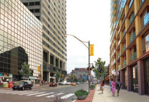
15 STREET ANIMATION Guideline: Create storefronts and pronounce building entrances on major streets. Development on the old bus terminal site will improve the urban condition along the south side of Eglinton Avenue between Duplex Avenue and Yonge Street by filling in the gap in the street wall that currently exists. The new development will have multiple pedestrian entrances to shops and lobbies, which will add to the pedestrian experience. On major streets it is desirable to maintain and continue retail at the ground floor, punctuated by well-defined residential and commercial building entrances (lobbies). Precedent image: to show how Eglinton Avenue may develop. The photo shows a brick-clad street wall with multiple entrances to retail, wide sidewalks with healthy trees. Existing condition along Eglinton Avenue View of concept plan along Eglinton Avenue looking east January


16 LINKAGE TO LANDSCAPED OPEN SPACE Guideline: Acknowledge the Courtyard and the Minto Midtown development with a view corridor, road or pedestrian plaza. The Minto Midtown development on the east side of Yonge Street, south of Eglinton Avenue is now complete. The development includes two residential towers and between them, a publicly accessible landscaped open space. The Minto open space is located directly on Yonge Street and is of high design quality. It would be desirable to have a balance of landscaped open spaces on the other side of the street by creating a landscaped amenity on the west side of Yonge Street directly opposite the Minto open space. In the interim, the existing plaza, which contains a TTC entrance, may be enhanced with further landscape and seating. There is also the opportunity to create a direct interior pedestrian connection upon the completion of redevelopment on the bus terminal lands. This pedestrian connection will link Yonge Street with the new park. In the long term, there is an opportunity to open up the existing street wall and have a second level pedestrian promenade which begins at Yonge Street and extends west. The pedestrian promenade would have gardens, shops and outdoor cafes and bring a high sense of urbanity to the Yonge Eglinton neighbourhood. Courtyard at the Minto Midtown Development Bus terminal site plan showing potential for an east-west pedestrian connection Precedent image: similar pedestrian precinct in Montreal 12


17 Aerial view looking west across Yonge Street towards the southwest quadrant of the intersection View along Yonge Street looking west to possible new raised pedestrian promenade above bus terminal with glass pavillion/ttc entrance View along Yonge Street looking west to possible new raised pedestrian promenade above bus terminal with glass pavillion/ttc entrance January


18 VEHICULAR ENTRANCES Guideline: Vehicular entrances should blend with the proposed new street wall and minimize disruption to pedestrian traffic. Vehicular access to new development on the southwest block at Yonge and Eglinton will occur from a new north-south street and from existing main streets. These openings should be integrated with the design of the building and blend in so as not to create any visual breaks in the street. They should also be designed in a manner to be safe to pedestrians and avoid hidden intersections. Precedent image: demonstrates success Proposed new north-south street in concept plan looking north 14 Entrance to parking will be visually integrated into the architectural design of the building


19 BUILDING MATERIALS AND RHYTHM Guideline: Building materials and rhythm should be compatible with neighbouring buildings. The rhythm of buildings along a street is a measure of the typical width of buildings or lot sizes. On main streets the width of buildings is typically larger than those on residential streets. As an example, along the east side of Yonge Street, north of Eglinton Avenue, the rhythm of buildings consist of multiple storefronts. As we try to encourage new development to fit in with its existing context, it is important that the existing rhythm of buildings be maintained. New buildings along Duplex and Berwick Avenues are to be designed in such a way as to reflect the residential scale of the buildings across the street. Brick cladding for the new buildings is encouraged to relate better to the existing houses. New buildings on Yonge Street or Eglinton Avenue should be articulated to maintain the existing rhythm of commercial and retail buildings on the street. Materials should be of a high quality such as limestone, granite or other natural materials. Large picture windows are desirable for the retail areas at the ground floor. View looking north along Duplex Avenue in concept plan with proposed townhouses (background) and existing houses (foreground) Precedent image: shows use of compatible materials, such as brick January


20 Precedent image: shows low scale townhouses in front of higher point towers 16

21 PEDESTRIAN PUBLIC REALM Guideline: Create a new and safe pedestrian public realm (during the day or night). Several urban design guidelines, which are part of this document, have been created to jointly create a safe and useable public realm. The built form policies, for example, will ensure that buildings front onto the new public spaces and streets. Streets with greater visibility, that are well lit, are by and large safer. Diagram showing sidewalks/public realm (in black) and possible pedestrian connections (orange lines) January


22 STREETSCAPE Guideline: Streetscapes are to be designed according to the City of Toronto Streetscape Manual. Streets are the most vital part of the public open space system and have a distinct position, identity and role within the fabric of the city. They comprise the majority of the city s public spaces and much of the quality of the physical public realms comes from their character. The City of Toronto Streetscape Manual outlines different street classifications based on their size and arterial characteristics. Different areas and neighbourhoods are also outlined as having unique design criteria. The streetscape manual will be used in the Yonge Eglinton Centre area for the designs of sidewalks, streetscape design, street lighting, tree details and other street furniture such as benches. Based on the character of the streets, sidewalks and streetscape will vary. In its entirety, the area will start to exhibit its own character through the use of coordinated design treatments and streetscapes. Granite accent paving will be required for all major streets, while the residential streets will have a different character with more greenery and grass boulevards. Precedent image: showing public realm 18


23 PUBLIC ART Guideline: Create opportunities for public art. Public art will play an important role in enhancing the aesthetic quality of the Yonge Eglinton Centre area. Opportunities for public art range from the integration of art ideas into streetscape open space and built form designs to the creation of independent sculptures. Gateways and visual corridor terminations could become prominent public art sites. It is anticipated that the City of Toronto s Private Developer Percent For Public Art Program will be a major contributor to the improvement of publicly accessible areas, both on private and public lands. Public art policies are guidelines referenced in the City s Urban Design Handbook. Precedent image: public art integrated into streetscape Precedent image: public art with park-like settings Precedent image: public art January


24 CEILING HEIGHTS AND PEDESTRIAN CONNECTIONS Guideline: Create higher floor-to-floor heights on the ground, second and underground concourse levels and strengthen below grade and internal pedestrian connections where possible. New development at Yonge and Eglinton should extend the underground shopping concourse where possible. Opportunities exist on both the northeast and southwest corners to link to and continue the underground shopping concourse. Transit improvements and links to the new bus terminal should continue to have improved connections to shops and retail. New development at Yonge and Eglinton should be able to adapt to changing uses over time. To best accommodate this change, floor-to-floor heights on those floors above and below ground floor should be high enough to accommodate a range of uses from residential to retail to community functions. We anticipate as an example, that street related buildings along the new north-south street may have live/work units at the ground floor. These live/work units may be entirely residential at first but may adapt over time to a mix of uses including service-oriented shops, such as dry cleaners, etc. Cross-section showing grade difference between Eglinton Avenue and Berwick Avenue View of proposed north-south street in concept plan with grade related townhouses or live/work units 20


25 TALL BUILDINGS Guideline: Utilize City of Toronto Design Criteria for Review of Tall Building Proposals. The Yonge Eglinton concept plan has envisioned various locations for point towers. The point tower would be the preferred form of high rise development. The merits of the point tower is that the buildings are slender, their shadows move quickly and they allow sun light to penetrate through them onto the streets and into the residential units. For point towers to achieve these attributes it is important to apply certain criteria that would ensure that the form and frequency of these buildings maintain the intent of the concept plan. This will be achieved by: Ensuring that the design and spacing of tall buildings create residential units that have adequate access to light and privacy. Ensure that the design and spacing of tall buildings permits adequate access to natural light and skyview to the surrounding streets and public realm, and does not unduly create excessive shadowing of the surrounding context. To achieve these objectives the point towers which have been incorporated into the concept plan all have floor plates which are less than 750 square metres and are spaced apart from each other a distance which is at least equal the width of the buildings themselves. Point towers should also be stepped back above the podium so they are less visible from the street and do not create a canyon effect'. It would also be desirable for the tower tops to be sculpted' by reducing the tower floor plates on the upper floors. This would improve the skyview and allow more light to penetrate onto the street. Other issues such as street wall cladding materials, shadows, weather protection, wind impacts and microclimate should all be considered in the design and placement of point towers in accordance with the City of Toronto Design Criteria for Review of Tall Building Proposals. January

26 THE GREEN DEVELOPMENT STANDARD Guideline: Utilize the Toronto Green Development Standard Checklist. Toronto like all built up areas, experiences the environmental impacts of urbanization including the deterioration of air and water quality. Toronto s various environmental pressures and the recognition that Toronto s buildings and sites play an important role in determining the quality of environment in which we live have given rise to the desire for Toronto to have a green development standard. Toronto needs a green development standard to improve the following: Air quality and climate change Energy use Water quality and efficiency Solid waste Urban forest health, quality of life habitat, light pollution Economic and social health The Toronto Green Development Standard contains performance targets and guidelines that relate to site and building design to promote better environmental sustainability of development. The Standard is a made-in-toronto approach that integrates existing City guidelines and targets with standards from private rating systems such as Leadership in Energy and Environmental Design (LEED) and Green Globes. The Toronto Standard is intended not to compete with rating systems like LEED, but to ensure that when there is a desire to build green in Toronto, local environmental objectives are met. The Standard will: Apply to new city-owned and affiliated projects Encourage green development amongst the private sector Be voluntary during the initial year of implementation while further study and consultation is conducted Applications for new developments in the Yonge Eglinton Centre will be reviewed in accordance with the Toronto Green Development Standard. 22
27 URBAN DESIGN CONCEPT PLANNING Urban Design Concept Plans The following concept planning studies are meant to illustrate how the Urban Design Guidelines may be implemented. The studies represent how future roads, parks and buildings could be arranged in the creation of a new neighbourhood on the southwest corner of Yonge and Eglinton. The plan calls for a new north-south street which would begin at Duplex and run east and then southward to Berwick Avenue. Street related buildings ranging from 3-6 storeys would frame the new street. Selected locations for higher point towers would ensure that they have a minimum negative impact on the residential neighbourhood and on each other. Three-dimensional massing studies were conducted to illustrate where higher buildings may be positioned so that they do not cast new shadows onto the existing context. Early in the working group process a shadow model was prepared to show what the extent of shadowing the existing zoning permissions would create. New shadows would be considered those which exceed those which are created by the existing zoning permissions. Possible new road configurations and building locations show parks and open space (in green), street wall buildings (in purple) and possible point tower locations (in red). Buildings and heights of towers which create new shadows onto the low density residential neighbourhoods were avoided in the concept plan and are discouraged. January


 and")
.")
28 Shadow study June 21, 10 a.m. Shadow study September 21, 10 a.m. Shadow study June 21, 12 p.m. Possible new road configurations and building locations show parks and open space (in green), street wall buildings (in purple) and possible point tower locations (in red). Shadow study September 21, 12 p.m. 24


29 Existing conditions model Long term build out massing model January

30 This drawing transforms the built form studies into an aerial perspective, which is more illustrative of the architectural character of the newer buildings in the Yonge Eglinton precinct. The drawing also communicates how the scale of development would change from three-storey townhouses along Duplex Avenue to higher point towers located closer to Yonge Street. 26

31 To better understand the concept plan, the following walking tour was presented to help illustrate, through drawings and graphics, what the experience may be like if one were to walk through the area at some time in the future after the area has been developed. Starting along Eglinton Avenue the tour would continue to Yonge Street and head south. One would experience the Minto landscaped open space and its related new public open space on the west side of Yonge Street. The tour would continue west to Berwick Avenue and then northward on the new north-south street and into the proposed new park, concluding at the residential street along Duplex Avenue. Along Eglinton Avenue the existing bus barns will be replaced by street related buildings six storeys in height. The sidewalk in this area will be 8-10 metres wide with an allée of trees planted in the boulevard. Retail shop fronts would line the street punctuated by entrances (lobbies) to residential or commercial buildings. A single vehicular entrance to the bus terminal may be proposed along Eglinton Avenue and would replace the multiple curb cuts, which currently exist. Close to Yonge Street a higher building up to 120 metres may be proposed. This tower should be stepped back from the podium to be less visible from the sidewalk. Eglinton Avenue plan and proposed street section Existing view looking east along Eglinton Avenue View of concept plan looking east along Eglinton Avenue January


32 View looking east along Eglinton Avenue, present day View looking east along Eglinton Avenue, after initial development View looking east along Eglinton Avenue after long-term development is complete 28

 on all four")


33 The corner of Yonge and Eglinton will remain an important intersection and crossroads for the city. Increased pedestrian activity will be accommodated by wider sidewalks and open space (interior and exterior) on all four corners. It would be desirable to mark the southwest corner with a larger interior atrium. The atrium would function as an entrance to both the transit station as well as to related shops and other commercial functions. Open space is also contemplated/desired on the northeast corner of Yonge and Eglinton. Yonge Street plan and street section Proposed new buildings on the east side of Yonge Street January


34 New buildings built along Yonge Street should maintain the existing set backs where appropriate and be set back further in other instances to allow for wider sidewalks. Retail activity should be continued at grade. Trees will also be planted in the boulevard. High quality building materials are encouraged, such as limestone or granite. Concrete is discouraged as a cladding material. New landscaped open space (the Courtyard at the Minto Midtown development) is located along Yonge Street as part of the proposed Minto development. The landscaped open space will provide for a mid-block pedestrian connection eastward. It would be desirable to balance this open space with a plaza, view corridor or a road running westward from Yonge Street. The following illustrations depict a pedestrian connection linking Yonge Street with the proposed new park on Duplex Avenue. Long term planning for this block must take into consideration such urban design opportunities which will bring a new urban amenity to the community. The pedestrian connection as proposed would incorporate outdoor cafes, shops and pavilions which would serve as the south entrance to the subway and transit. View of the Minto street wall along Yonge Street with proposed landscaped open space A new north-south road is proposed for the block. The road is designed to absorb traffic which would be generated by the new development of the block. The View along Yonge Street looking west to possible new pedestrian promenade with glass pavillion/ttc entrance View of possible new pedestrian promenade looking east towards Yonge Street and the Minto landscaped open space 30


35 road may also provide some of the access to the bus terminal. The design of the road and streetscape is meant to reflect an urban street. The street will be framed by buildings which are 6 storeys in height creating a street wall. Higher buildings ranging from 60 metres to 85 metres should step back from the street wall and be positioned apart from each other as demonstrated on the concept plan. The streetscape will be designed with green boulevards to provide a residential feel. Stone and brick cladding are preferred for the street wall and the use of concrete as a cladding material is discouraged. Townhouse or live/work units will be encouraged to occupy the lower floors providing a greater sense of community. Vehicular entrances to parking and loading should be incorporated into the design of the street wall in order to create a continuous streetscape. Proposed plan and street section of new north-south street View of proposed north-south street in concept plan with grade related townhouses or live/work units January


36 A new neighbourhood park will be created as part of the redevelopment of the southwest block. The park will be designed and programmed through a separate community process. On the concept plan the park has been located along Duplex Avenue to best create a transition between the neighbourhood and the buildings which are located close to Yonge Street. The park should be framed by grade related units to enhance the visibility and safety of the park. Buildings which front onto Duplex Avenue should be residential in scale. The concept plan envisions threestorey townhouses with buildings which are set back 2 to 3 metres from the street. The 2 to 3 metre setback would allow for private front yards and may also protect a majority of the mature trees which currently exist along Duplex Avenue. Buildings along Duplex Avenue are encouraged to be brick clad to blend with the existing character of the houses on the street. Additional main street development consisting of buildings up to six storeys in height with at-grade retail and office or residential on subsequent floors may be located along Duplex Avenue at Eglinton Avenue. Proposed plan and street section looking north along Duplex Avenue View looking west towards Duplex Avenue in the concept plan. The new community park will be framed with residential buildings to enhance visibility and safety of the park. The new community park 32


37 View of the concept plan looking south towards Duplex Avenue View of the concept plan looking south towards Duplex Avenue January

38 View from Duplex Avenue looking northeast towards future park and developments 34
39
40 January 2009 City Planning Urban Design
Clairtrell Area Context Plan
 Clairtrell Area Context Plan March 2005 Urban Development Services City Planning Contents 1. Introduction... 4 2. Development Structure... 6 2.1 Streets... 7 2.1.1 Sheppard Avenue and Bayview Avenue...
DRAFT Northeast Quadrant of Kipling Avenue and Highway 7 DRAFT AUGUST 29, Goals Land Use. The goals of this Plan are to:
 AUGUST 29, 2017 12.15 Northeast Quadrant of Kipling Avenue and Highway 7 12.15.1 Goals 12.15.2 Land Use The goals of this Plan are to: 12.15.2.1 General Provisions: a) Ensure the development of a compact
(DC1) Direct Development Control Provision DC1 Area 4
 Direct Development Control Provision DC1 Area 4") . General Purpose (DC) Direct Development Control Provision DC Area 4 The purpose of this Provision is to provide for an area of commercial office employment and residential development in support of the
. General Purpose (DC) Direct Development Control Provision DC Area 4 The purpose of this Provision is to provide for an area of commercial office employment and residential development in support of the
Context Plan and Urban Design Guidelines for the lands west of Provost Drive
 Concord Park Place Context Plan and Urban Design Guidelines for the lands west of Provost Drive Amendment to the Bessarion-Leslie Context Plan October 2013 Concord Park Place Urban Design Guidelines The
ELMVALE ACRES SHOPPING CENTRE MASTER PLAN
 ELMVALE ACRES SHOPPING CENTRE MASTER PLAN Contents 1.0 INTRODUCTION... 2 2.0 LOCATION... 2 3.0 EXISTING CONTEXT... 2 4.0 VISION & GUIDING PRINCIPLES... 2 5.0 LAND USE AND BUILT FORM... 4 5.1 St. Laurent
URBAN DESIGN BRIEF URBAN DESIGN BRIEF 721 FRANKLIN BLVD, CAMBRIDGE August 2018
 URBAN DESIGN BRIEF URBAN DESIGN BRIEF 721 FRANKLIN BLVD, CAMBRIDGE August 2018 DESIGN BRIEF CONTENTS PART A 1.0 INTRODUCTION 2.0 DESCRIPTION & ANALYSIS OF SITE CONTEXT 3.0 DESIGN CONSTRAINTS AND OPPORTUNITIES
Community Design Plan
 Gardena General Plan 2006 Authority While the is not a required element of a General Plan, it is included because improving the community appearance and image is paramount to the overall quality of life
Official Plan Review: Draft Built Form Policies
 PG.30.1 REPORT FOR ACTION Official Plan Review: Draft Built Form Policies Date: May 15, 2018 To: Planning and Growth Management Committee From: Chief Planner and Executive Director, City Planning Division
Policies and Code Intent Sections Related to Town Center
 Policies and Code Intent Sections Related to Town Center The Town Center Vision is scattered throughout the Comprehensive Plan, development code and the 1994 Town Center Plan. What follows are sections
Urban Design Brief to 1557 Gordon Street & 34 Lowes Road West
 Urban Design Brief 1533 to 1557 Gordon Street & 34 Lowes Road West Reid s Heritage Homes Ltd. & 883928 Ontario Ltd. and RHH Property Management Ltd. City of Guelph Zoning By-law Amendment November 2017
URBAN DESIGN BRIEF. 2136&2148 Trafalgar Road. Town of Oakville
 URBAN DESIGN BRIEF 2136&2148 Trafalgar Road Town of Oakville Prepared By: METROPOLITAN CONSULTING INC For 2500674 Ontario Inc November 2016 TABLE OF CONTENTS Page No. 1.0 Introduction/Description of Subject
TALL BUILDING GUIDELINES
 TALL BUILDING GUIDELINES Urban Design Guidance for the Site Planning and Design of Tall Buildings in Milton May, 2018 A Place of Possibility Contents 1.0 INTRODUCTION 1 1.1 What is a Tall Building? 2
Regency Developments. Urban Design Brief. Holyrood DC2 Rezoning
 Regency Developments Urban Design Brief Holyrood DC2 Rezoning Stantec Consulting Ltd. 7-31-2017 1. Overview Regency Developments intends to rezone the lands located at 8510 and 8511 93 Avenue, within the
appendix and street interface guidelines
 appendix five: building and street interface guidelines appendix 5 building and street interface guidelines BOULEVARDS Boulevards are generally characterized by higher levels of traffic movement at higher
Uptown Rideau Street Secondary Plan [Amendment #166, January 12, 2016]
![Uptown Rideau Street Secondary Plan [Amendment #166, January 12, 2016]](/thumbs/76/73760497.jpg "Uptown Rideau Street Secondary Plan [Amendment #166, January 12, 2016]") [Amendment #166, January 12, 2016] The policies of this Secondary Plan are in effect, save and except for the property at 560 Rideau Street, for which there remains a site specific appeal to this Secondary
[Amendment #166, January 12, 2016] The policies of this Secondary Plan are in effect, save and except for the property at 560 Rideau Street, for which there remains a site specific appeal to this Secondary
CONTENTS 8.0 LAND USE 8.1 GENERAL LAND USE 8.2 RESIDENTIAL 8.3 MIXED USE 8.4 COMMERCIAL 8.5 EMPLOYMENT LANDS
 8-2 Land Use 8.0 LAND USE CONTENTS 8.1 GENERAL LAND USE 8.1.1 Uses provided for in all Land Use Designations 8.1.2 Uses prohibited in Hazardous Lands, Hazardous Sites and Special Policy Areas 8.1.3 Uses
East Bayshore Road Neighbourhood
 East Bayshore Road Neighbourhood Northridge Property Management Urban Design Brief 3195 East Bayshore Road City of Owen Sound January 2016 East Bayshore Road Neighbourhood Northridge Property Management
Highland Village Green Design Guidelines
 Highland Village Green Design Guidelines Publishing Information Title Highland Village Green Design Guidelins Author The City of Calgary Status DRAFT - Proposed document subject to changes Additional Copies
URBAN DESIGN BRIEF REPORT
 URBAN DESIGN BRIEF REPORT PREPARED FOR 2568401 ONTARIO INC NEW GASBAR, CONVENIENCE STORE & CARWASH DEVELOPMENT @ 1509 FANSHAWE PARK ROAD WEST LONDON, ONTARIO GAMA ENGINEERING INC. PROJECT NUMBER 1669 PREPARED
New-Cast Mixed-use Development Proposal King Street West, Newcastle, Ontario
 URBAN DESIGN BRIEF New-Cast Mixed-use Development Proposal King Street West, Newcastle, Ontario TABLE OF CONTENTS: 1.0 Executive Summary 2.0 Creating Vibrant and Sustainable Urban Places: Excerpts from
DRAFT DRAFT DRAFT DRAFT
 # 19 EXPAND GREEN AND OPEN SPACES AND COMMUNITY FACILITIES IN TANDEM WITH NEW DEVELOPMENT The role of Eglinton will change in the coming years, along with the intensity of activity and land uses. As more
401/Keele Provincial Campus Ontario Realty Corp.
 1.0 INTRODUCTION 1.1 Site Location and Description The study area consists of approximately 74 acres (30 ha) located in the Keele Street and Wilson Avenue area. It is bounded by Wilson Avenue to the north,
WEST LOOP DESIGN GUIDELINES CHECKLIST
 WEST LOOP DESIGN GUIDELINES CHECKLIST Section 1.0 General Strategies 1.1 DESIGN EXCELLENCE: ENCOURAGE HIGH QUALITY AND INNOVATIVE DESIGN OF NEW BUILDINGS WITHIN THE WEST LOOP WITHOUT BEING PRESCRIPTIVE
CHAPTER 5: GUIDING PRINCIPLES
 CHAPTER 5: GUIDING PRINCIPLES The following 10 principles were developed based on public consultation, planning policy and the background analysis conducted during Phase 1. The Guiding Principles significantly
BESSARION-LESLIE CONTEXT PLAN
 Development in the Bessarion-Leslie area will be consistent with the following urban design guidelines. They provide a framework for development in the area and are to be read in conjunction with the urban
Duplex Design Guidelines
 Duplex Design Guidelines Adopted by Council May 29, 2006 Prepared By: Table of Contents 1.0 Application and Intent 1 2.0 Areas of Application 2 3.0 Design Principles 3 4.0 Design Guidelines 4 4.1 Site
QUEEN-RIVER SECONDARY PLAN
 34 QUEEN-RIVER SECONDARY PLAN 34. QUEEN RIVER SECONDARY PLAN 1. INTRODUCTION The Queen-River area is approximately 6.4 hectares and is located at the eastern edge of the Downtown as shown on Map 34-1.
URBAN DESIGN BRIEF 181 Burloak Drive, Oakville
 URBAN DESIGN BRIEF 181 Burloak Drive, Oakville February 2017 Our File: 1730B 230-7050 WESTON ROAD / WOODBRIDGE / ONTARIO / L4L 8G7 / T: 905 761 5588/ F: 905 761 5589/WWW.MHBCPLAN.COM TABLE OF CONTENTS
Urban Design Manual PLANNING AROUND RAPID TRANSIT STATIONS (PARTS) Introduction. Station Study Areas
 Introduction. Station Study Areas") 111111 PLANNING AROUND RAPID TRANSIT STATIONS (PARTS) Introduction The ION rapid transit system will link Waterloo, Kitchener and Cambridge through a central transit corridor (CTC). There are a number
111111 PLANNING AROUND RAPID TRANSIT STATIONS (PARTS) Introduction The ION rapid transit system will link Waterloo, Kitchener and Cambridge through a central transit corridor (CTC). There are a number
[PLANNING RATIONALE] For Site Plan Control and Lifting of Holding Zone By-Law 101 Champagne Avenue. May 23, 2014
![[PLANNING RATIONALE] For Site Plan Control and Lifting of Holding Zone By-Law 101 Champagne Avenue. May 23, 2014](/thumbs/75/71599615.jpg "[PLANNING RATIONALE] For Site Plan Control and Lifting of Holding Zone By-Law 101 Champagne Avenue. May 23, 2014") [PLANNING RATIONALE] For Site Plan Control and Lifting of Holding Zone By-Law 101 Champagne Avenue May 23, 2014 Contents 1.0 Introduction... 2 2.0 Site Context... 2 2.1 Adjacent Uses... 2 Figure 1: Site
[PLANNING RATIONALE] For Site Plan Control and Lifting of Holding Zone By-Law 101 Champagne Avenue May 23, 2014 Contents 1.0 Introduction... 2 2.0 Site Context... 2 2.1 Adjacent Uses... 2 Figure 1: Site
Urban Design Brief December 23, 2015 Southside Construction Group Official Plan & Zoning By-Law Amendment
 Urban Design Brief Proposed Official Plan & Zoning By-Law Amendment 3244, 3263 and 3274 Wonderland Road South Southside Group December 23, 2015 TABLE OF CONTENTS Page No. INTRODUCTION... 1 SECTION 1 LAND
City-Initiated Official Plan and Zoning By-law Amendments, Yonge-Eglinton Centre Focused Review Final Report
 STAFF REPORT ACTION REQUIRED City-Initiated Official Plan and Zoning By-law Amendments, Yonge-Eglinton Centre Focused Review Final Report Date: January 5, 2009 To: From: Planning and Growth Management
Wide asphalt driveway abutting school property. garage built with incompatible materials, too close to park. incompatible fencing materials
 Wide asphalt driveway abutting school property incompatible fencing materials garage built with incompatible materials, too close to park Lack of plantings as a buffer between private property and open
Agenda. 7 Wright Crescent Urban Design Study. Public Meeting and Urban Design Workshop. 1 INTRODUCTION AND BACKGROUND (City of Kingston)
") Urban Design Study Public Meeting and Urban Design Workshop October 02, 2013 Agenda 1 INTRODUCTION AND BACKGROUND (City of Kingston) 2 URBAN DESIGN STUDY PRESENTATION (Antonio Gomez-Palacio, DIALOG) 3
Urban Design Study Public Meeting and Urban Design Workshop October 02, 2013 Agenda 1 INTRODUCTION AND BACKGROUND (City of Kingston) 2 URBAN DESIGN STUDY PRESENTATION (Antonio Gomez-Palacio, DIALOG) 3
WINDSOR GLEN DESIGN GUIDELINES
 WINDSOR GLEN DESIGN GUIDELINES Adopted by Council, 2006 WINDSOR GLEN REDEVELOPMENT DESIGN GUIDELINES August 2006 1.0 Master Plan Organization For this area of the Coquitlam Town Centre, a mix of high,
Bel-Air Lexus Automobile Service Station
 Bel-Air Lexus Automobile Service Station Design Brief 443-447 McArthur Avenue Ottawa April 30, 2015 14-1299-MCA Site Details Application: Site Plan Control Legal Description and Municipal Addresses: 443
YONGE STEELES CORRIDOR SECONDARY PLAN. Young + Wright / IBI Group Architects Dillon Consulting Ltd. GHK International (Canada) Ltd.
 Ltd.") PART A: PREAMBLE 1.0 PURPOSE The purpose of this Secondary Plan is to provide a development framework for intensification of the Yonge/ Steeles corridor including the north side of Steeles Avenue West
PART A: PREAMBLE 1.0 PURPOSE The purpose of this Secondary Plan is to provide a development framework for intensification of the Yonge/ Steeles corridor including the north side of Steeles Avenue West
599 Kennedy Road - Official Plan Amendment and Zoning Amendment Application - Preliminary Report
 STAFF REPORT ACTION REQUIRED 599 Kennedy Road - Official Plan Amendment and Zoning Amendment Application - Preliminary Report Date: March 7, 2017 To: From: Wards: Reference Number: Scarborough Community
4.9 Mendocino Avenue Corridor Plan Design Guidelines
 4.9 Mendocino Avenue Corridor Plan Design Guidelines The Mendocino Avenue Corridor Plan addresses the area between College Avenue and Steele Lane. Mendocino Avenue is a busy arterial that runs parallel
5.1 Site Plan Guidelines
 5. Community Core Guidelines Development of the Community Core will take place by plan of subdivision and site plan approval. It will occur in a phased manner that will reflect the timing of residential
CONTENTS 6.1 URBAN DESIGN
 6-2 Urban Design and Sustainable Development 6.0 URBAN DESIGN AND SUSTAINABLE DEVELOPMENT CONTENTS 6.1 URBAN DESIGN 6.1.1 General Policies 6.1.2 The Public Realm 6.1.3 Streets and Blocks 6.1.4 Streetscapes
BROADVIEW PLANNING STUDY Community Consultation Meeting 4. January 2016
 BROADVIEW PLANNING STUDY Community Consultation Meeting 4 January 2016 2 Agenda 6:00 pm Open House and Displays 7:00 pm Introductions, Agenda Review and Welcome 7:10 pm Presentation Broadview Planning
GUIDELINES WESTON LOCATION: URBAN DESIGN GUIDELINES
 Development in the Weston area will be consistent with the following urban design guidelines. The guidelines correspond to Site and Area Specific Policies 45, 46, 47, 48, 49, 51, 52 and 232 in Chapter
*** DRAFT 2 FOR PUBLIC REVIEW ***
 6.7 The area is generally bounded by the Red Hill Valley Parkway to the west, Lake Avenue to the east, the Queen Elizabeth Way (QEW) to the north, and by the properties just south of Queenston Road to
Mark-up of the effect of the proposed Bronte Village Growth Area OPA No.18 on the text of section 24, Bronte Village, of the Livable Oakville Plan
 Mark-up of the effect of the proposed Bronte Village Growth Area OPA No.18 on the text of section 24, Bronte Village, of the Livable Oakville Plan Notes: This document is provided for information purposes
Derry Green Corporate Business Park
 Town of Milton Derry Green Corporate Business Park Urban Design Guidelines BMI/Pace - June 2010 Draft 3 Prepared by: Brook McIlroy Planning + Urban Design / Pace Architects Suite 300-51 Camden Street Toronto,
DRAFT. 10% Common Open Space
 % OF CHARLOTTE IS CATEGORIZED AS A. LAND USES : Placeholder map displaying location of Place Type GOALS: Accommodate XX% of future growth. Provide a concentration of primarily commercial and civic activity
Urban Design Brief. 583, 585 and 589 OXFORD STREET EAST. Salt Clinic Canada Inc.
 Urban Design Brief 583, 585 and 589 OXFORD STREET EAST Salt Clinic Canada Inc. February 3, 2013 TABLE OF CONTENTS Page No. INTRODUCTION... 1 SECTION 1 LAND USE PLANNING CONCEPT... 1 1.1 The Subject Property...
Urban Design Guidelines Townhouse and Apartment Built Form
 Urban Design Guidelines Townhouse and Apartment Built Form Town of Wasaga Beach Table of Contents 1. Introduction 1.1. Purpose 1.2. Urban Design Principles 1.3. Application of Guidelines 2. Site Design,
GUIDELINES BAYVIEW INSTITUTIONS CONTEXT PLAN LOCATION PLAN COMPONENTS URBAN DESIGN GUIDELINES
 Development in the Bayview Sunnybrook area will be consistent with the following urban design guidelines. They provide a framework for development in the area and are to be read in conjunction with the
2418 KHALSA GATE, OAKVILLE URBAN DESIGN BRIEF APPLICATION FOR ZONING BY-LAW AMENDMENT. Prepared for: Golden Arch Tech Investment Corporation
 APPLICATION FOR ZONING BY-LAW AMENDMENT Prepared for: Golden Arch Tech Investment Corporation NOVEMBER 2015 I TABLE OF CONTENTS INTRODUCTION... 1 SECTION 1... 2 Contextual Analysis... 2 Oakville Official
lot flankage Y street 16m 6m landscape strip for large site 3m landscape strip for small medium site
 Commercial General Commercial Objectives Create developments compatible with adjacent land uses in scale, function and character Define a consistent and attractive street edge with quality landscaping,
Housing and Coach House Guidelines - Ladner
 Housing and Coach House Guidelines - Ladner Policy D.8: Encourage Compatible Housing Design Encourage housing design that is sensitive to existing single family housing neighbourhoods by requiring a design
HIGHLAND VILLAGE GREEN URBAN DESIGN PRINCIPLES/GUIDELINES
 URBAN DESIGN GUIDING PRINCIPLES/GUIDELINES CONTEXT/CHARACTER The City of Calgary s Municipal Development Plan (MDP), Transit-Oriented Development (TOD) Policy Guidelines and Main Street/Corridor policy
Authority: Toronto and East York Community Council Item 26.14, as adopted by City of Toronto Council on October 8, 9, 10 and 11, 2013 CITY OF TORONTO
 Authority: Toronto and East York Community Council Item 26.14, as adopted by City of Toronto Council on October 8, 9, 10 and 11, 2013 CITY OF TORONTO BY-LAW No. 1507-2013 To adopt Amendment No. 183 to
13 THORNHILL YONGE STREET STUDY IMPLEMENTATION CITY OF VAUGHAN OPA 669 AND TOWN OF MARKHAM OPA 154
 13 THORNHILL YONGE STREET STUDY IMPLEMENTATION CITY OF VAUGHAN OPA 669 AND TOWN OF MARKHAM OPA 154 The Planning and Economic Development Committee recommends the adoption of the recommendations contained
BENSON / HUNT TERTIARY PLAN
 BENSON / HUNT TERTIARY PLAN TABLE OF CONTENTS 1.0 INTRODUCTION 1.1 Purpose 2 1.2 How to Read This Plan 3 1.3 Tertiary Plan Context 3 1.4 Vision and Principles 5 1.5 Public Consultation 5 2.0 PLANNING CONTEXT
Workshop 3. City of Burlington Waterfront Hotel Planning Study. September 14, The Planning Partnership
 Workshop 3 City of Burlington Waterfront Hotel Planning Study September 14, 2017 The Planning Partnership The Waterfront Hotel Planning Study 01 The Brant & Lakeshore Planning Study will establish a Strategic
burlington mobility hubs study Downtown Burlington Mobility Hub
 burlington mobility hubs study Downtown Burlington Mobility Hub Draft Precinct Plan Workbook PIC #3, September 7, 2017 downtown mobility hub objectives City staff and their consultants are proposing an
SECTION TWO: Overall Design Guidelines
 SECTION TWO: Overall Design Guidelines This section provides overall design principles and guidelines for the Gardnerville Mixed-use Overlay. They provide criteria for mixed-use places consisting of residential,
4. INDUSTRIAL 53 CASTLE ROCK DESIGN
 4. INDUSTRIAL 53 CASTLE ROCK DESIGN CASTLE ROCK DESIGN 54 4. INDUSTRIAL Overview Well-designed and attractive industrial centers are the product of blending economic realities with both functional and
Bank Street Secondary Plan
 1.1 Introduction The is a guide to the long term design and development of the portion of Bank Street between Riverside Drive and Ledbury Park, and provides direction on land use, built form, design, parking,
178 Carruthers Properties Inc.
 178 Carruthers Properties Inc. Planning Rationale for 178 Carruthers Avenue Site Plan Control Application June 2014 Table of Contents 1.0 Introduction 2.0 Overview of Subject Property 3.0 Current Zoning
Site Planning. 1.0 Site Context. 2.0 Pedestrian Circulation Systems. Pag e 2-23
 The following photographs from throughout the country illustrate key urban design principles. Photographs are provided to illustrate the overall urban design concepts described in Chapter 1 of the Downtown
1354 CARLING AVENUE FORMAL RESUBMISSION HOLLOWAY LODGING
 1354 CARLING AVENUE FORMAL RESUBMISSION HOLLOWAY LODGING DECEMBER, 2017 THE SITE 1354 CARLING AVENUE The subject property is at a key gateway to the Carlington Neighbourhood, and when combined with future
ARCHITECTURAL DESIGN REVIEW For submission with development proposals in the City s Tourist Area
 ARCHITECTURAL DESIGN REVIEW For submission with development proposals in the City s Tourist Area Property Owner: Property Address: Architect: Application Number: Date: Please describe in detail how the
GUIDELINES EXHIBITION PLACE LOCATION: OBJECTIVES. Structure Plan URBAN DESIGN GUIDELINES
 Development in the Exhibition Place lands will be consistent with the following urban design guidelines. They provide a framework for new development of the lands and are to be read in conjunction with
PORT WHITBY COMMUNITY
 PORT WHITBY COMMUNITY SECONDARY PLAN UPDATE COMMUNITY IMPROVEMENT PLAN URBAN DESIGN GUIDELINES September 2015 DRAFT PROPOSED AMENDMENT NUMBER # to the Whitby Official Plan PURPOSE: The intent of this Amendment
Winston Road Neighbourhood Town of Grimsby. Urban Design Manual. February 2016
 Winston Road Neighbourhood Town of Grimsby Urban Design Manual February 2016 FEBRUARY 2016 Winston Road Neighbourhood Urban Design Manual Town of Grimsby 1 2 3 Contents Introduction Document Overview...
Urban Design Brief. 875 Wellington Road. Proposed One-Storey Fast Food Restaurant and Two-Storey Restaurant. Wellington Harlech Centre Inc.
 Urban Design Brief 875 Wellington Road Proposed One-Storey Fast Food Restaurant and Two-Storey Restaurant Wellington Harlech Centre Inc. Prepared By: (519) 433-7587 info@yorkdev.ca May 3 rd 2013 1 Table
The Village. Chapter 3. Mixed Use Development Plan SPECIFIC PLAN
 The Village SPECIFIC PLAN Chapter 3 3.1 INTRODUCTION 3.1.1 Purpose This Chapter describes the development regulations applicable to the Mixed-Use and Transit Center Planning Areas. These form-based regulations
13. New Construction. Context & Character
 13. New Construction Context & Character While historic districts convey a sense of time and place which is retained through the preservation of historic buildings and relationships, these areas continue
GUIDELINES REPLACEMENT HOUSING GUIDELINES LOCATION INTRODUCTION URBAN DESIGN GUIDELINES
 Replacement housing in the former City of North York will be consistent with the following urban design guidelines. They provide a framework for residential re-development in the former City of North York
PUBLIC RIGHT-OF-WAY IN THIS CHAPTER PUBLIC REALM
 PUBLIC RIGHT-OF-WAY This section provides design guidelines for improvements in the public right-of-way. The public right-of-way refers to streets, sidewalks, non-vehicular thoroughfares, parks and greenways
Bayshore Boulevard Home Improvement District Design Guidelines
 Bayshore Boulevard Home Improvement District Design Guidelines guidelines for New construction projects and major alterations IN the bayshore boulevard home improvement special use DISTRICT SAN FRANCISCO
1 Eglinton Avenue East Zoning Amendment Application Final Report
 STAFF REPORT ACTION REQUIRED 1 Eglinton Avenue East Zoning Amendment Application Final Report Date: September 29, 2017 To: From: Wards: Reference Number: Toronto and East York Community Council Director,
Public Consultation Summary: Lakeview Place Making Workshop January 30, 2008.
 Page 1 of 11 Public Consultation Summary: Lakeview Place Making Workshop January 30, 2008. 1.0 Introduction: On January 30, 2008 the City of Mississauga, in conjunction with the consulting team of Brook
VILLAGE OF SKOKIE Design Guidelines for Mixed-Use Districts NX Neighborhood Mixed-Use TX Transit Mixed-Use CX Core Mixed-Use
 VILLAGE OF SKOKIE Design Guidelines for Mixed-Use Districts NX Neighborhood Mixed-Use TX Transit Mixed-Use CX Core Mixed-Use TABLE OF CONTENTS CHAPTER 1 SITE DESIGN Purpose 1 CHAPTER 2 SITE DESIGN Streetscape
TRAFALGAR ROAD
 158-2192 TRAFALGAR ROAD URBAN DESIGN BRIEF PREPARED BY KLM PLANNING PARTNERS INC. FOR DUNPAR DEVELOPMENTS INC. TOWN OF OAKVILLE JUNE 2012 TABLE OF CONTENTS 1 INTRODUCTION 1.1 Project Description...1 1.1.1
DRAFT. October Wheaton. Design Guidelines
 October 2011 DRAFT Wheaton Design Guidelines 2 Draft - Design Guidelines - Wheaton Sector Plan Contents 04 Section 1: Introduction 06 Section 2: Context 08 Section 3: Design Guidelines 09 Goal 1: Create
Multi family Residential Development Permit Area
 City of Kamloops KAMPLAN Multi family Residential Development Permit Area PURPOSE The purpose of this Development Permit Area (DPA) is to establish objectives and provide guidelines for the form and character
SCHEDULE 'A' TO BY-LAW as Amended by AMENDMENT NO. 90 TO THE WHITBY OFFICIAL PLAN
 SCHEDULE 'A' TO BY-LAW 6413-10 as Amended by 6553-11 AMENDMENT NO. 90 TO THE WHITBY OFFICIAL PLAN SECTION A: GROWTH PLAN CONFORMITY PURPOSE: LOCATION: BASIS: The purpose of this Amendment is to: conform
Tel: (705) Fax: (705)
 Fax: (705)") 521 and 525 Essa Road City of Barrie Tel: (705) 812-3281 Fax: (705) 812-3438 Email: INFO@IPSCONSULTINGINC.com 1 5 0 D U N L O P S T R E E T E A S T, S U I T E 2 0 1, B A R R I E O N T A R I O L 4 M 1 B
521 and 525 Essa Road City of Barrie Tel: (705) 812-3281 Fax: (705) 812-3438 Email: INFO@IPSCONSULTINGINC.com 1 5 0 D U N L O P S T R E E T E A S T, S U I T E 2 0 1, B A R R I E O N T A R I O L 4 M 1 B
Figure Example of out door dining in the public right-of-way.
 Section 2 Core Area Goal 2.2.1 To maintain and enhance the character of existing streets in the Downtown Area. Character Figure 2.2.1 Example of out door dining in the public right-of-way. A. Provide street
The Master Plan Framework
 The Master Plan Framework The East Harbour Master Plan advances the development of 60 acres of former industrial lands east of the Don River. The Master Plan outlines a vision for a vibrant, transit-oriented
Planning Rationale Zoning By-law Amendment Application October Centrepointe Drive - Ottawa, Ontario
 ZONING BYLAW AMENDMENT OCTOBER 2011 Table of Contents Table of Contents... i 1 Introduction... 1 1.1 Site Location... 1 1.2 Overview of Proposed Development... 1 2 Context... 6 2.1 Community Character...
AIRPORT BUSINESS PARK
 PIER MAC PETROLEUM INSTALLATION LTD. AIRPORT BUSINESS PARK DEVELOPMENT APPLICATIONS March 2003 4.1 Airport Business Park Development Permit Area 4.1.1 Justification/Design Concept The design concept envisioned
BROADWAY-ARBUTUS POLICIES. Adopted by City Council on July 7, NOTE: To be considered in combination with applicable guidelines
 50 City of Vancouver Land Use and Development Policies and Guidelines Community Services, 453 W. 12th Ave Vancouver, BC V5Y 1V4 F 873.7344 fax 873.7060 planning@city.vancouver.bc.ca BROADWAY-ARBUTUS POLICIES
Othello Neighborhood Design Guidelines
 Othello Neighborhood Design Guidelines 1 S ORCAS ST S OTHELLO ST 42ND AVE S 2 Note: Design Review does not apply to all zones. See Citywide Guidelines for details. Additionally, zoning areas on this map
TABLE OF CONTENTS 1.0 INTRODUCTION... 3
 TABLE OF CONTENTS 1.0 INTRODUCTION... 3 1.1. BACKGROUND... 3 1.2. THE PROPOSAL... 5 2.0 EXISTING POLICY FRAMEWORK... 5 2.1. PROVINCIAL POLICY STATEMENT (PPS)... 5 2.2. CITY OF LONDON OFFICIAL PLAN (OP)...
11.5 Kipling Avenue Corridor Secondary Plan
 11.5 Kipling Avenue Corridor Secondary Plan ADOPTED BY VAUGHAN CITY COUNCIL NOT YET APPROVED BY THE ONTARIO MUNICIPAL BOARD 11.5.1 Development Principles and Objectives The following principles support
New Street Proposed Redevelopment Architecture & Urban Design Brief
 2130 2136 New Street Proposed Redevelopment Architecture & Urban Design Brief Prepared By: Cynthia Zahoruk Architect Inc. 3077 New Street, Burlington, ON, L7N 1M6 TABLE OF CONTENTS Background and Objective
City of Vaughan Urban Design Guidelines for Infill Development in Established Low-Rise Residential Neighbourhoods
 City of Vaughan Urban Design Guidelines for Infill Development in Established Low-Rise Residential Neighbourhoods DRAFT - September 2016 Contents 1. Introduction 1 2. Policy Context 3 3. Characteristics
Urban Design Brief Fanshawe Park Road. Competition Toyota
 Urban Design Brief 1300 Fanshawe Park Road Competition Toyota May 2, 2014 TABLE OF CONTENTS Page No. INTRODUCTION... 1 SECTION 1 LAND USE PLANNING CONTEXT... 1 1.1 The Subject Lands... 1 1.2 The Proposal...
LOW DENSITY RESIDENTIAL
 LOW DENSITY RESIDENTIAL Corner lots with coach houses to increase diversity, provide unity to the streetscape and increase eyes on the street. Garages and ancillary units accessed via rear lanes. Parking
CREATE A VIBRANT MIXED-USE COMMUNITY
 CREATE A VIBRANT MIXED-USE COMMUNITY Land Use Public Realm Plan Built Form Heritage Tell us what you think! Place a sticky note here or leave us a comment form LAND USE The land use framework of this Secondary
Mixed Use Centres Development Permit Guidelines
 1 Mixed Use Centres Development Permit Guidelines Area Commercial or Mixed Use development occurring in City Centre, Urban Centre, Neighbourhood Centre, or Institutional Complex land use designations is
Town Center (part of the Comprehensive Plan)
") Town Center (part of the Comprehensive Plan) Mercer Island Town Center Looking North (2014) In 1994, a year-long process culminated in a set of design guidelines and code requirements for the Town Center
Town Center (part of the Comprehensive Plan) Mercer Island Town Center Looking North (2014) In 1994, a year-long process culminated in a set of design guidelines and code requirements for the Town Center
Urban Design Brief Milton Thompson Developments Limited
 Urban Design Brief Milton Thompson Developments Limited Mixed Use Node Louis St. Laurent Avenue at Thompson Rd. Milton, Ontario September 11, 2014 Prepared by MSAi Michael Spaziani Architect Inc. 1 INTRODUCTION
NEIGHBORHOOD 3: UNIVERSITY EDGE
 NEIGHBORHOOD 3: UNIVERSITY EDGE Aerial View of North Indiana Avenue EXISTING CHARACTER The University Edge neighborhood represents the primary town/gown interface between the campus and the city of Bloomington,