PITKIN COUNTY AIRPORT LANDSCAPE MASTERPLAN
|
|
|
- Lorin Chandler
- 5 years ago
- Views:
Transcription
1

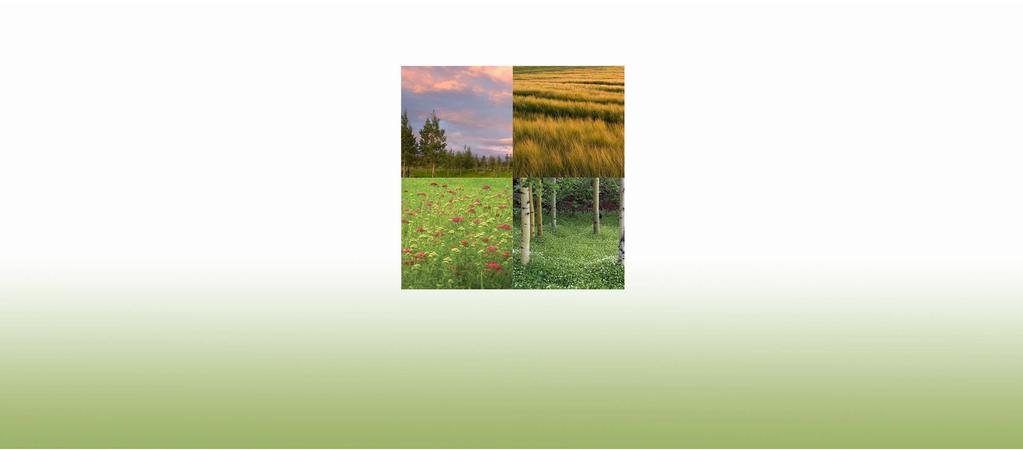
2 WELCOMING VIEW OF AIRPORT CAMPUS AND AN IM- PORTANT SECTION OF THE EXPERIENCE INTO ASPEN. SOUTH MEADOW IS PART OF THE NATIVE GRASS, SAGE, AND WILDFLOWER MEADOW EXTENDING FROM BUTTERMILK MOUNTAIN DOWN TO THE RIVER. EN- HANCE THE MEADOW WITH WILDFLOWERS AND PUR- SUE OPPORTUNITIES FOR PEOPLE TO EXPERIENCE THE SITE. TRANSITION FROM MEADOW TO RANCH. CREATE GROVE PLANTINGS SURROUNDING CLUSTERS OF BUILDINGS. MANICURE AND CONTOUR THE LANDFORM TO APPEAR MORE NATURAL IN SHAPE AND SIZE, ADD A PERMANENT IRRIGA- TION SYSTEM, AND EXTEND TREE CLUSTERS FROM THE AOC THROUGH THE LANDFORMS. PRESERVE HISTORIC RANCH CHARACTER; ENHANCE THE OWL CREEK STREAM CORRIDOR WITH RIPARIAN VEGETATION, AND REJUVENATE THE ASPEN AND OAK GROVES. MAINTAIN AND ENHANCE THE BEAUTIFUL VIEW OF THE MEADOW, PASTURE, AND RUN- WAY. TRANSITION FROM EXISTING TOPPED COTTONWOODS ALONG OWL CREEK TO MEDIUM HEIGHT TREES. ENHANCE LANDSCAPING AT THE TERMINAL TO CREATE A GATEWAY FOR THE ASPEN EXPERIENCE AND EMPHASIZE AN ATMOSPHERE OF A VILLAGE IN COMBINATION WITH THE BUSINESS CENTER TRANSITION FROM THE RIPARIAN AREA TO THE AIRPORT TERMINAL VILLAGE WITH CLUSTERS OF ASPEN, SPRUCE, AND PINES TO CREATE A BALANCE OF SCREENING AND VISTAS INTO THE AIRPORT. THE MEADOW FLOWERS AND GRASSES WILL CONTINUE THROUGH THE TREE GROVES AND EVOLVE THE MORE MANICURED LANDSCAPE OF THE AIRPORT VILLAGE. SITE PLAN

3 SUMMARY Installation Budget SOUTH MEADOW 216,000 - South Meadow - Meadow Between De-Ice Apron and Hwy 82 PASSENGER TERMINAL AREA 1,325,000 - Airport Road from Main Entrance to Slip Ramp - Long Term Parking to Terminal - Entry, Loop Road, Short Term Pk - North Promontory - Main Entrance at Signal Light - Airport Road Adjacent to Lot B AOC AND OWL CREEK ROAD 61,000 - Indian Mound - AOC Meadow at Owl Creek Road AIRPORT RANCH TBD - Airport Ranch PATIO SHELTER PLANTINGS, ATCT, AND FBO 65,000 - Airport Road from ATCT to FBO - Patio Shelter Plantings NORTH END MEADOW AND RIPARIAN REHAB 260,000 - Wetland Rehabilitation - Owl Creek Plantings - Wildflower Meadow Total $1,927, Year Phased Implementation at $150,000/Year SITE PLAN BUDGET SUMMARY


4 PHASING CONCEPTS SUMMARY Each Year We Would Devote a Percentage of the Years Landscape Budget to a Project in Each Category. This Will Allow the Money to be Utilized Effectively for Immediate Aesthetic Improvements as Well as Long Term Benefits. Category 1: On Going Projects That Require Yearly Attention - Terminal Planter Pots Category 2: Complete Existing Projects For Desired Outcome - Finishing Touches on Existing Projects - 2 year Period - AOC Roof Plantings - AOC Landscape Plantings - Patio Shelter Plantings Category 3: Investing In Long Term Projects That Require Initial Investment With Long Term Visual Benefits - Utilize Irrigation Water Rights. Environmentally Responsible to Use Non-Potable Water. A - Transitioning Terminal Landscaping From City Water to Ditch Water B - Opportunities to Introduce the Irrigation Stream as a Landscape Feature C - Temporary Re-usable Irrigation System to Establish Wildflower Areas Using a Pump System and Above Ground Piping and Sprinklers - Transition Cottonwoods at Owl Creek to Medium Stature Grove - Opportunities for Micro-Hydro Electric on Owl Creek Near the Ranch - Include Bioswales for Storm Water Run-off - Public and Private Partnerships at the Airport Ranch i.e. Hay Fields and Cattle - Electric Car Charging Stations Near Terminal - Creating Wildflower Meadows Over Time Throughout the Airport Campus Category 4: New Installations For Immediate Visual Impact - Cluster Tree Plantings - Terminal Entry Gardens Category 5: Interactive Public Spaces - South Meadow Interactive Signs and Trails - Public Gathering Spaces, Interpretive Signs, and Art - Trail Network and Connections PHASING CONCEPTS SUMMARY


5 BOCC WORK SESSION SUMMARY Jim Elwood, Airport Director, and Shannon Murphy, Landscape Architect, met with BOCC at their May 12, 2009 work session. They presented an overview of landscape projects installed on the airport campus and the Landscape Master Plan document developed to guide the airport with installation projects for the next years. Specific elements of the Landscape Master Plan discussed at the work session were: 1. Identify the many diverse ecosystems and landscape characteristics of the airport area and surrounding environments. 2. Illustration of landscape designs/strategies to enhance site features and ecological systems 3. Conceptual installation scopes of work and associated budgets 4. Installation strategies and phasing 5. Ongoing maintenance and continued stewardship Following the landscape presentation, the Commissioners were asked to provide input and comment on the landscape design concepts, phasing and installation strategies. Below are their comments and suggestions. BOCC Work Session Comments - Urged the team to be mindful and aware of future projects and not invest in items that will be demolished in a few years. - Agreed with the categorizing approach of yearly budget, to disperse the funds into projects with immediate benefit as well as investing in long term projects with future aesthetic payoffs. - Agreed with enhancing terminal gardens to promote a great first impression our community. - Promoted additional planting and maintaining an intensity of wildflowers throughout the airport campus. - Concluded that we provide perennials that benefit honey bees as they are on the decline. - Urged that wildflower plantings should include a sequence of flowering blooms from Spring through Fall. - Encouraged minimal manicured areas and increase the natural vegetation. - Supported the idea of transitioning Cottonwoods at Owl Creek to medium stature grove over next few years. - Agreed with enhancing perennial and tree plantings along the sidewalk to the long term parking area and the shuttle service staging area. - Supported the idea to enhance areas near terminal and long term parking. - Encouraged the concept of planting aspen trees that could be grown in place and transplanted at a mature size onto future projects. - Promoted the bioswale idea and irrigation stream water features. - Supported utilizing irrigation water rights. Environmentally responsible to use non potable water. - Urged the team to provide future space for public gathering events. - Suggested the team work with local non-profits for public art displays throughout the campus i.e. Anderson Ranch, Red Brick Center for the Arts, Aspen Art Museum. - Supported ideas involving green solutions i.e. electric car parking stations and micro-hydro electric from Owl Creek. Priorities for AOC Roof Plantings 2- Owl Creek view plane 3- Terminal area, providing for potential future projects 4- North ramp tree groves 5- Wildflowers BOCC WORK SESSION SUMMARY
6 APPENDIXES


7 ENHANCE STREAM COURSE WITH PLANTING EXISTING OWL CREEK BIKE TRAIL. WORK WITH PITKIN COUNTY OPEN SPACE AND TRAILS TO DEVELOP INTER- PRETIVE AND INFORMATIONAL GATHERING SPACES. AIRPORT SERVICE ROAD OWL CREEK ROAD GRASS AND WILDFLOWER MEADOW MIXED WITH EXISTING NATIVE VEGETATION HIGHWAY 82 SOUTH MEADOW


8 GRASS AND WILDFLOWER MEADOW PLANTINGS AIRPORT SERVICE ROAD TO DEFINE PLANTING EDGE OWL CREEK ROAD AND TRAIL ENHANCE LANDFORMS BETWEEN OWL CREEK ROAD AND AIRPORT SERVICE ROAD ENHANCE TREE PLANTINGS FOR SCREENING EXISTING AIRPORT OPERATIONS CENTER OWL CREEK ROAD AND TRAIL OWL CREEK ROAD


9 PLANT NEW RIPARIAN SHRUBS AND REMOVE DAMAGED/DEAD SHRUBS PLANT NEW MID-STATURE TREES AND REMOVE MATURE COTTONWOOD TREES IN STAGES AS NEW TREES FILL IN SEED WILDFLOWERS IN EXISTING MEADOW EXISTING HAY FIELD AIRPORT SERVICE ROAD HIGHWAY 82 NORTH END MEADOW AND RIPARIAN REHABILITATION


10 SEEDED WILDFLOWERS ENHANCE SPRUCE GROVES PATIO SHELTERS HIGHWAY 82 Unit NORTH END PATIO, ATCT, AND FBO


11 PRUNE AND CLEAN EXISTING COTTONWOODS NEW PROMONTORY LANDSCAPE DESIGN ADD PATHWAY AND LANDSCAPE TO EXISTING PARKING LOT ENTRANCE WHEN PARKING IS CONVERTED TO AIRCRAFT APRON ENHANCE WILDFLOWER PLANTINGS AT ENTRY WILDFLOWER MIX Unit Unit MAIN ENTRANCE TO TERMINAL


12 WILDFLOWER MEADOW WILDFLOWER MEADOW PLANTED IN BOTH MEDIAN AREAS AIRPORT SERVICE ROAD HIGHWAY 82 HIGHWAY 82 SOUTH OF TERMINAL


13 LOT B PARKING HIGHWAY 82 LOT B PARKING GREEN WALL IMAGE ELECTRIC CAR PARKING AND CHARGING STATIONS BOULDER RETAINING WALL CRUSHER FINES WALKING PATH VERTICAL FREE-STANDING GREEN WALLS AIRPORT ROAD AND TERMINAL ENTRANCE PATH

14 OR RP AI T AD RO SPRUCE EXISTING LOT B PARKING COTTONWOOD SEATING AREA VIEW OF PROPOSED OF SEATING AREA Airport Road Adjacent to Lot B Installation Item Notes Prune existing vegetation and general clean-up Remove weeds spot spray and hand pull Topsoil for fine grading Fine tune grading for path and picnic area Walking path and picnic area crusher fines Seating stones stone slabs 18" tall, 2' wide, 2'-5' long Cottonwood trees Spruce trees Spruce trees Planted wildflowers Seed wildflowers hand broadcast Sod Irrigation new zones General Conditions; contingency, mobilization, port-a-pottie (if applicable) Landscape Architectural Design and Construction Observation Subtotal CRUSHER FINES WALKING PATH Quantity 24 labor hours 24 labor hours 70 cubic yards allowance allowance 9 each 5 2.5" caliper 4 16' tall 5 14' tall allowance allowance allowance allowance Yearly maintenance required after installation; fertilizing, weed maintenance and irrigation monitoring Unit price Total Price $40 $960 $80 $1,920 $65 $4,550 $5,000 $10,000 $500 $4,500 $400 $2,000 $1,700 $6,800 $1,500 $7,500 $3,000 $2,000 $2,000 $15,000 $6,523 $7,175 $77,968 $4,000 A I R P O R T R OA D A J AC E N T TO LOT B


15 AIRPLANE PARKING VIEWING AREA ROCK OUTCROPS FOR SEATING ASPEN GROVE TERMINAL SERVICE AREA TERMINAL BUILDING PASSENGER DROP-OFF AND PICK-UP NORTH PROMONTORY


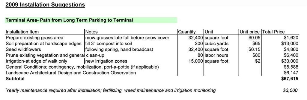
16 ADDITIONAL ASPEN AND WILDFLOWER REVEGETATION CLEAN-UP EXISTING PLANT AND SHRUB MATERIAL LONG TERM PARKING PLANT ADDITIONAL ASPEN ALONG WALKING PATH. TREES TO BE TRANSPLANTED ON AIRPORT CAMPUS TO ACCOMMO- DATE FUTURE TERMINAL REDEVELOPMENT PLANT ADDITIONAL ASPEN IN ISLAND TERMINAL AIRCRAFT APRON AIRPORT TAXI SERVICE HIGHWAY 82 EXISTING ROADS AND WALKWAYS REMAIN UNCHANGED WILDFLOWER AND GRASS MEADOW TERMINAL PATH TO LONG TERM PARKING


17 2009 LANDSCAPE BUDGET SUMMARY
GYPSUM PARKWAY CORRIDOR ENHANCEMENT Gypsum, Colorado. Schematic Design January 2015
 GYPSUM PARKWAY CORRIDOR ENHANCEMENT Gypsum, Colorado Schematic Design January 2015 1 2 3 4 5 6 7 8 9 DESIGN WORKSHOP Landscape Architecture Land Planning Urban Design Tourism Planning Asheville Aspen Austin
Hidden Pointe Landscape Master Plan. June, archi terra
 Hidden Pointe Landscape Master Plan June, 2006 t h e archi terra g r o u p 1 Table of Contents Background Purpose and Goals of the Master Plan Master Plan Process Existing Conditions Entrance Hidden Pointe
Table of Contents. 1.0 Introduction Scope of Work Existing Conditions Previous Concepts Objectives 6. 6.
 1.0 Introduction 1 2.0 Scope of Work 1 3.0 Existing Conditions 2 4.0 Previous Concepts 4 5.0 Objectives 6 6.0 Considerations 7 7.0 Concept Development 8 8.0 Plant Palette 13 Table of Contents STANDARD
2011 ASLA Design Awards. Coyote Gulch Honor Award and Land Stewardship Designation Valerian LLC. Environmental Restoration and Reclamation
 2011 ASLA Design Awards Honor Award and Land Stewardship Designation Valerian LLC Environmental Restoration and Reclamation Project Name: Category : Project Location: 5 2011 Environmental Restoration and
F. The following uses in the HR District: attached single-family dwellings, condominiums, and institutional uses; and
 1102 DESIGN REVIEW 1102.01 PURPOSE AND APPLICABILITY Section 1102 is adopted to provide standards, criteria, and procedures under which design review may be approved. Design review is required for: A.
Blood Alley Square/Trounce Alley Redesign
 June 216 Kick-Off Events Questionnaire and Engagement Summary Background The City of Vancouver is redesigning Blood Alley Square and Trounce Alley, important public spaces in the heart of Gastown, which
SOUTH DAKOTA STATE UNIVERSITY GROUNDS MANAGEMENT PLAN FY 2013
 SOUTH DAKOTA STATE UNIVERSITY GROUNDS MANAGEMENT PLAN FY 2013 SOUTH DAKOTA STATE UNIVERSITY GROUNDS MANAGEMENT PLAN Table of contents: Introduction & Goals 03 Prioritization 03 Improvement Strategies 07
Hayesville Downtown Improvement Projects Martha Eberle DCA Intern Summer 2010
 Downtown Improvement Projects Martha Eberle DCA Intern Summer 2010 Project 1: Trail etwork Downtown Trail Hia wa ssee Clay County Health Dept Spikebuck Mound and Village Site July 14, 2010 July 14, 14,
4. INDUSTRIAL 53 CASTLE ROCK DESIGN
 4. INDUSTRIAL 53 CASTLE ROCK DESIGN CASTLE ROCK DESIGN 54 4. INDUSTRIAL Overview Well-designed and attractive industrial centers are the product of blending economic realities with both functional and
Roanoke Rapids Streetscape Master Plan. City Council Presentation
 SCHEDULE: Stakeholder Meeting/Kick off November,2016 Master Planning Phase (November March 2017) Public Meeting #1 December 13, 2016 Review Meeting with Key Stakeholders Refine Concepts Based on Input
ROCHESTER INSTITUTE OF TECHNOLOGY Active Transportation Improvements 2010
 ROCHESTER INSTITUTE OF TECHNOLOGY Active Transportation Improvements 2010 In 2008, the Rochester Institute of Technology (RIT) completed a Comprehensive Parking and Transportation Study. Recommendations
Standards (R-3) Figure B-11: R-3 Residential Standards Exhibit
 Figure B-11: R-3 Residential Standards Exhibit") Avila Ranch Avila Ranch Specific Plan Development Standards High Medium Density - High Residential Density Residential Lot and Building Lot and Standards Building (R-3) Standards (R-3) EXAMPLES These sketches
Avila Ranch Avila Ranch Specific Plan Development Standards High Medium Density - High Residential Density Residential Lot and Building Lot and Standards Building (R-3) Standards (R-3) EXAMPLES These sketches
Landscaping Standards
 CHAPTER 29 ARTICLE 403 29.403 Landscaping Standards Purpose: The purpose of this section is to protect and promote the public health, safety and general welfare by requiring landscaping in relation to
Philip A. Ginsburg, General Manager Toks Ajike, Acting Planning and Capital Program Director
 Date: March 7, 2018 To: Through: From: Subject: Recreation and Park Commission Capital Committee Philip A. Ginsburg, General Manager Toks Ajike, Acting Planning and Capital Program Director Dan Mauer,
SOUTH LAKE TAHOE LINEAR PARK LANDSCAPE IMPROVEMENTS
 SOUTH LAKE TAHOE LINEAR PARK LANDSCAPE IMPROVEMENTS JUNE 2012 Scope of Work for Linear Park Landscape Improvements Prepare conceptual landscape design with increased lawn areas, additional accent planting,
Silverdale Regional Center
 Silverdale Regional Center Vision for Silverdale Regional Center The Silverdale Regional Center Plan (Plan) will guide the evolution of the Silverdale Regional Center from a collection of strip malls and
Girdwood Cemetery Girdwood, Alaska
 Miners Pond Shelter Council Circle Woodl Trails Overlooks Committal Shelter Courts Woodl Burial Bridge to Beaver Pond Trail Protected Stream Valleys Columbarium Court Shelter Woodl Trails Woodl Cremation
Landscape and Streetscape Design 2.5
 Landscape and Streetscape Design 2.5 2.5.1 Goals 2.5.2 Planting 2.5.3 Sidewalks and Pavement 2.5.4 Furnishings 2.5.5 Walls 2.5.6 Lighting 2.5.7 Stormwater 2.5.8 Street Cross Sections 2.5 LANDSCAPE AND
UBC URBAN STUDIO, FALL 2002 PEDESTRIAN ORIENTED
 SECTION B PEDESTRIAN ORIENTED PATTERN: CITY OF VANCOUVER B.1 Vision Overview Regional Framework Energy 50% of all energy used within the Region to be produced by the Region. Energy production methods to
Silver Creek Subdivision Public Park
 Silver Creek Subdivision Public Park Design Team: team80026 Munding Design Lead Consultant Gaia Designs Landscape Architect Wildrye Design Landscape Architect Akamai Design Civil Engineer introduction
2011 ASLA Design Awards. Westside Creeks Restoration Plan Merit Award AECOM, Fort Collins. Planning & Urban Design
 2011 ASLA Design Awards Westside Creeks Restoration Plan Merit Award AECOM, Fort Collins Planning & Urban Design Project Fact Sheet Category of Entry: Rotating Specialty Award: 2011 2011 ASLA Colorado
Corridor Enhancements
 Corridor Enhancements Safety is MoDOT s first priority in widening and rebuilding I-70 across the state of Missouri. MoDOT also understands that the interstate - and its interchanges and overpasses - are
ROARING FORK RAILROAD CORRIDOR
 ROARING FORK RAILROAD CORRIDOR CONSERVATION AREA ASSESSMENT August 28, 2017 Prepared For: Covenant Enforcement Commission Roaring Fork Transportation Authority Prepared By: NEWLAND PROJECT RESOURCES, INC
SITE INTRODUCTIONS AND OVERVIEW
 SITE INTRODUCTIONS AND OVERVIEW The City s formal Open Space Program was established in 1990 to implement long-standing policies that called for the protection of the farmlands and wild areas that surround
Seneca Meadows. Block 4 Locate office, technology, and medical development adjacent to I Screen views of garage structures from I-270.
 Seneca Meadows Seneca Meadows has an industrial park in its southern end and a mixed-use employment area planned for the north end. The district benefits from extensive I-270 visibility, stream valley
Forest Grove Park Master Plan
 Workshop 03 Steering Committee Meeting 2:00 5:00 PM Public Open House 5:00 7:00 PM February 21, 2012 Agenda February 21, 2012 Schedule and planning process update. Preliminary Program review. Concept plan
A Master Plan for High Park s Hillside Garden and other Ornamental Gardens: Recommendations from the High Park Natural Environment Committee
 www.highparknature.org mail@highparknature.org A Master Plan for High Park s Hillside Garden and other Ornamental Gardens: Recommendations from the High Park Natural Environment Committee September 2015
V. Vision and Guiding Principles
 V. Vision and Guiding Principles The Master Plan for the Powers Ferry Corridor seeks a foundation in the desires of the community. At times, various elements of the community offered opposing viewpoints,
Lehigh Acres Land Development Regulations Community Planning Project
 Lehigh Acres Land Development Regulations Planning Effort Summary In July, 2010 Commissioner Frank Mann invited the Lehigh Acres community to start discussing how to achieve their recently adopted community
Ecological Restoration at the Las Vegas Springs Preserve. Von K. Winkel, Ph.D.
 Ecological Restoration at the Las Vegas Springs Preserve Von K. Winkel, Ph.D. The Las Vegas Springs Before Disturbance The springs are very large. A small creek flows from each of 3 or 4 springs and
This presentation has been developed by the Sustainable Sites Initiative for general audiences
 This presentation has been developed by the Sustainable Sites Initiative for general audiences Copyright 2011 by the Sustainable Sites Initiative. All rights reserved. 2011 2010 Sustainable Sites Initiative
April 11, 2016 Park Board Chair and Commissioners General Manager Vancouver Board of Parks and Recreation New Brighton Salt Marsh - Preferred Concept
 TO: FROM: SUBJECT: April 11, 2016 Park Board Chair and Commissioners General Manager Vancouver Board of Parks and Recreation New Brighton Salt Marsh - Preferred Concept RECOMMENDATION A. THAT the Vancouver
PUBLIC ENGAGEMENT & SIX THEMES OF THE PLAN
 Connecting the heart of Eagle to the soul of the river - Kathy Chandler-Henry, Commissioner Eagle County CHAPTER 1 PUBLIC ENGAGEMENT & SIX THEMES OF THE PLAN town of eagle - river corridor plan 1 PUBLIC
 Health Sciences City The available land area, although limited, combined with the unique partnership between the primary institutions and the supporting partnerships of the development interests within
ARTICLE IV: DEVELOPMENT STANDARDS 404 MASTER PLANNING
 IV 13 404 MASTER PLANNING Master Planning through the Site Analysis (Master Planning Site Analysis) or Planned Development (Master Planning Planned Development) is provided to encourage development which
doyle + o troithigh landscape - architecture
 doyle + o troithigh landscape - architecture REPORT: PROJECT: LANDSCAPE DESIGN REPORT. STUDENT HOUSING DEVELOPMENT AT WESTWOOD HOTEL SITE. DATE: MAY 2018. www.doyle-otroithigh.com Landscape design report,
City of San Juan Capistrano PROJECT PRESENTATION NORTHWEST OPEN SPACE COMMUNITY PARK (CIP 09209) March 22, 2016 FOR THE PROJECT PRESENTATION
 March 22, 2016 FOR THE PROJECT PRESENTATION") City of San Juan Capistrano PROJECT PRESENTATION PROJECT PRESENTATION FOR THE NORTHWEST OPEN SPACE COMMUNITY PARK (CIP 09209) PLANNING COMMISSION 1 PROCESS & OBJECTIVES A. Develop a new Concept Plan for
City of San Juan Capistrano PROJECT PRESENTATION PROJECT PRESENTATION FOR THE NORTHWEST OPEN SPACE COMMUNITY PARK (CIP 09209) PLANNING COMMISSION 1 PROCESS & OBJECTIVES A. Develop a new Concept Plan for
Potential Green Infrastructure Strategies May 6, 2015 Workshop
 Potential Green Infrastructure Strategies May 6, 2015 Workshop Background The City of Cortland is developing the Tioughnioga Urban Headwaters Green Infrastructure Action Plan with funding from the National
Creating a sense of arrival at campus entrances and at the primary entrances to the Campus Core.
 16.0 LANDSCAPE DESIGN GUIDELINES ELEMENT In campus planning, design professionals whose focus is the outdoors must be sensitive to transitions from building to open space, the need for common areas and
Corridor Identity. Section 9. Introduction. Corridor Guiding Principles
 Corridor Identity An attractive and healthy community is a critical element of a quality place, and the design of quality places is a balance between environmental, economic, and social considerations.
The Vision. Photo provided by The Minervini Group. 46 Vision, Objectives & Strategies
 Vision, Objectives & Strategies The is the public framework and guide for future development of the Grand Traverse Commons. The establishes public polices for infrastructure, the preservation of natural
Landscape Questionnaire
 Landscape Questionnaire This form was developed to assess your landscape needs and preferences. Please fill out all relevant questions and skip those that are not relevant. There is room for further elaboration
Town of Lyons Parks Flood Recovery Planning Process. Photograph courtesy of Ed Bruder
 Town of Lyons Parks Flood Recovery Planning Process Photograph courtesy of Ed Bruder Lyons Parks and Recreation Flood Recovery Update 1. Meadow Park Phase II - Project PW20B1 Estimated Completion: Summer
Community Design Guidelines. Port Wallace DRAFT
 Community Design Guidelines Port Wallace DRAFT Energy 1 2 3 Nature Movement Connections Built Form DRAFT Layout Energy 1 Nature Community Design Guidelines GREAT COMMUNITIES PROTECT, CELEBRATE, AND CONSERVE
Master Plan. of a new entry ramp as depicted on the Proposed First Floor Plan.
 Master Plan The completed Master Plan is an aggregation of the input gathered in the focus group, steering committee, staff and public open house meetings. The Design Team completed the Draft Master Plan
B L A C K D I A M O N D D E S I G N G U I D E L I N E S for Multi-family Development
 B L A C K D I A M O N D D E S I G N G U I D E L I N E S for Multi-family Development Adopted June 18, 2009 This section of the Design and focuses on site planning and design guidance for new multi-family
City of Missoula and Missoula County Open Space Planning Open House
 City of Missoula and Missoula County Open Space Planning Open House FEBRUARY 6, 2018 The following slides contain the display board content from the open house. Please use boards to answer questions in
OPPORTUNITIES AND CONSTRAINTS - OXBOW PARK ENTRANCE AND PUT-IN
 OPPORTUNITIES AT OXBOW EXISTING WETLANDS Site is undeveloped and we can design a park that works well from the start. SAND BEACH Potential to eliminate invasive species. DEBRIS (CONCRETE, OLD CARS) VEGETATION
OBJECTIVE 1.1: To develop and adopt a Landscape Master Plan for the University of Central Florida campus by 2015.
 Goals, Objectives and Policies GOAL 1: To create an exemplary campus outdoor environment that promotes comfort, security, sustainability, and a regional sense of place. and to create a rich and horticulturally
CANADA 150 SPECIAL EDITION Evaluation Form 2017
 CANADA 150 SPECIAL EDITION Evaluation Form 17 2 P age 17 - Canada 150 Special Edition - Evaluation Form Community: Province: Category: The evaluation is based on 8 criteria, divided into the following
ECOLOGICALLY-BASED CITY PARK MASTER PLAN
 ECOLOGICALLY-BASED CITY PARK MASTER PLAN AUTHORED BY: KELSEY BLAHO CAYLA COTHRON MAY 12, 2016 Project Summary Table of Contents Existing Conditions Stormwater Management Circulation Wildlife Habitat and
Landscaping and Landscape Architecture
 A. General Overview This planning and landscape section has been prep ared to provide Property Owners, Architects, Contractors, and Builders/Developers with important information related to the development
MISSISSIPPI GORGE REGIONAL PARK MASTER PLAN
 MISSISSIPPI GORGE REGIONAL PARK MASTER PLAN Minneapolis Park and Recreation Board CAC MEETING #1 APRIL 23, 2018 AGENDA Mississippi Gorge Regional Park Master Plan CAC #1 01 / Welcome and Calling Circle
SYRINGA VALLEY SPECIFIC PLAN NARRATIVE
 SYRINGA VALLEY SPECIFIC PLAN NARRATIVE Introduction With this application, Pleasant Valley South LLC ( Pleasant Valley ) seeks the City of Boise s approval of a new Specific Plan Ordinance to be added
City of Langford Green Development Checklist
 City of Langford Green Development Checklist The following Green Development Checklist creates a sustainability standard for all comprehensive development within the City of Langford. The commitments made
Rocky Areas Project Guidance HABITAT
 Rocky Areas Project Guidance HABITAT Introduction Rocky habitats are surface areas dominated by exposed rock, such as mountain peaks, inland cliffs, buttes and rocky outcrops. In many cases, rocky areas
Village of Pemberton DOWNTOWN ENHANCEMENT INITIATIVE FRONTIER STREET PILOT PROJECT WE NEED YOUR HELP TO REVIEW THE PLAN
 Village of Pemberton DOWNTOWN ENHANCEMENT INITIATIVE FRONTIER STREET PILOT PROJECT WELCOME TO THE NEW FRONTIER STREET! WE NEED YOUR HELP TO REVIEW THE PLAN The Village of Pemberton would like your feedback
Presentation to Parks and Open Space Advisory. Committee September 22, 2016
 Flood Planning & Preliminary Design Services for South St. Vrain Creek Restoration at Hall Ranch Presentation to Parks and Open Space Advisory Prepared for: Boulder County, Colorado Committee September
SOUTH PARK. Construction of a Portion of South Park at Fresh Kills Park, Staten Island
 SOUTH PARK Construction of a Portion of South Park at Fresh Kills Park, Staten Island FRESHKILLS PARK FIRST PHASE OF SOUTH PARK FRESHKILLS PARK CONTEXT SOUTH PARK EXISTING CONDITIONS PROJECT OPPORTUNITIES
Juneau Watershed Partnership
 Juneau Watershed Partnership Native Plant Resource Center Final Report A Partners for Fish and Wildlife Project Prepared for: U.S. Fish and Wildlife Service For Grant #F11C00552 Prepared by: The Juneau
MER BLEUE URBAN EXPANSION AREA
 MER BLEUE PARKS MER BLEUE URBAN EXPANSION AREA August 207 INTRODUCTION The objective of the Area Parks Plan (APP) is to outline the overall distribution of parks, amenities and greenspace connections within
The Turtle Creek Master Plan- A Summary. July 7, 2011
 The Turtle Creek Master Plan- A Summary July 7, 2011 Background During 2004, TCA commissioned highly regarded Antonio Di Mambro & Associates to create a Master Plan for the Turtle Creek Corridor. The resulting
Clair-Maltby Community visioning
 Clair-Maltby Community visioning workshop #1 Summary April 27th, 2017 Table of Contents INTRODUCTIon 1 PURPOSE 1 CONSULTATION STRUCTURE 2 PARTICIPANT FEEDBACK 3 VISIONING EXERCISE 8 ONLINE SURVEY RESULTS
Courtice Main Street Study Community Vision Workshop PLANNING SERVICES DEPARTMENT
 Courtice Main Street Study Community Vision Workshop PLANNING SERVICES DEPARTMENT July 22, 2009 Tonight s Meeting 7:00 pm Introduction David Crome, Director of Planning 7:05 Presentation Stasia Bogdan,
Centennial Hall Planning Comments Public Meetings, 9/19/2011. General Comments
 Centennial Hall Planning Comments Public Meetings, 9/19/2011 General Comments Space/Location Too tight. Acquire more space (Women s Club?) Is there a more central visitor center site? Site very important
Lowe Park Master Plan Update Marion, IA August 25 th, 2011
 Lowe Park Master Plan Update Marion, IA August 25 th, 2011 Lowe Park Master Plan Update Concept Plan - June 1 st, 2011 Agenda 1 - INTRODUCTION Vision Statement Aerial of Existing Condition 2 MASTER PLAN
BISCUIT RUN PARK MASTER PLAN
 BOARD OF SUPERVISORS November 14, 2018 BISCUIT RUN PARK MASTER PLAN COUNTY OF ALBEMARLE ANHOLD ASSOCIATES Contents Project Introduction Property Background County Park Planning Process Existing Site &
Southeast Michigan Council of Governments
 Southeast Michigan Council of Governments SEMCOG Green Infrastructure Activities Regional Green Infrastructure Vision GLRI Green Streets EPA Technical Assistance MDOT Grants Green Infrastructure Vision
Landscape and fencing requirements of this Chapter shall apply to all new landscaped areas.
 Chapter 19.06. Landscaping and Fencing. Sections: 19.06.01. Purpose. 19.06.02. Required Landscaping Improvements. 19.06.03. General Provisions. 19.06.04. Landscaping Plan. 19.06.05. Completion of Landscape
Port Lavaca Future Land Use
 Port Lavaca Future Land Use Introduction The City of Port Lavaca is beginning to see sustained growth, after many years of relative stable population. New single family homes, apartments, and businesses
Surrey Ecosystem Management Study
 Surrey Ecosystem Management Study Green Infrastructure Network Opportunities Public Open House & Information Session June 24 th, 2010 EMS Process Ecological Inventory Ecological Assessment Management Policy
Denver Moves: Transit Task Force
 Insert transit picture Denver Moves: Transit Task Force Meeting #8 October 5, 2017 1. Welcome & Introductions Opening remarks and housekeeping Task Force and audience introductions Upcoming events and
Highland Falls Waterfront Redevelopment Feasibility Study Village Board Meeting March 20, 2017
 Village Board Meeting March 20, 2017 Agenda I. Public Meeting #1 Visioning Summary II. Public Meeting #2 Comment Summary III. IV. IV. Case Study: Milton Train Station Schematic Design Concepts Schedule/Next
Century Park to Ellerslie Road Preliminary Engineering
 Century Park to Ellerslie Road Preliminary Engineering South LRT Extension Stakeholder Information Panel Brochure March 2010 www.edmonton.ca/lrtprojects LRT Station (left) and Transit Centre Architectural
Evaluation Form 2016
 Evaluation Form 2016 2 P age 2016 Evaluation Form Community: Province: Category: The evaluation is based on 8 criteria, divided into the 6 following sections, assessing 4 sectors of the community: Tidiness
Providence Waterfront Park
 I-195 Redevelopment Parcels Providence Waterfront Park June 30, 2014 I-195 30% Design Review 1 November 19, 2012 endorses open space design. 2 Design Chronology October 2013 10% Design Submitted for both
Urban Planning and Land Use
 Urban Planning and Land Use 701 North 7 th Street, Room 423 Phone: (913) 573-5750 Kansas City, Kansas 66101 Fax: (913) 573-5796 Email: planninginfo@wycokck.org www.wycokck.org/planning To: From: City Planning
Table of Contents. Elm Avenue Improvement Plan City of Waco, Texas. Introduction 1. Existing Context 1 Figure 1 2.
 Table of Contents Introduction 1 Existing Context 1 Figure 1 2 Plan Guidelines 3 Future Urban Form 4 The West-End 4 Main Street 6 The East-End 7 Figure 2 9 Public Improvement Recommendations 7 General
3. VISION AND GOALS. Vision Statement. Goals, Objectives and Policies
 Vision Statement Queen Creek s interconnected network of parks, trails, open spaces and recreation opportunities provide safe and diverse activities and programs that sustain its unique, small town, equestrian
Client #: Dawson /91. NRCS Tract #(s): Location: Fleming Memorial Park Field #(s): Program(s): Urban Project Name: Date:
: Location: Fleming Memorial Park Field #(s): Program(s): Urban Project Name: Date:") Natural Resource Stewardship Plan Jackson Soil and Water Conservation District 89 Alder Street Central Point, Oregon 97502 Ph. (541) 664-1070 www.jswcd.org Client Name: Elisa Dawson, City of Rogue River
Natural Resource Stewardship Plan Jackson Soil and Water Conservation District 89 Alder Street Central Point, Oregon 97502 Ph. (541) 664-1070 www.jswcd.org Client Name: Elisa Dawson, City of Rogue River
Programming Ideas for Parks Professionals
 Programming Ideas for Parks Professionals 6 How to Use this Information This is a list of ideas, suggestions and tips for promoting and incorporating the healthy in nature movement in your parks. Whether
Preliminary Sketch Plan for Fort Hunter Park
 Preliminary Sketch Plan for Fort Hunter Park Public Presentation November 19, 2009 Dauphin County Parks and Recreation 100 Fort Hunter Road Harrisburg, PA 17110 (717) 599-5188 www.dauphinc.org THOMAS COMITTA
APPENDIX C. Architectural and Environmental Design Standards. Environmentally sensitive areas should be protected.
 APPENDIX C Architectural and Environmental Design Standards Environmentally Sensitive Areas Goal A. Environmentally sensitive areas should be protected. Development, such as roads, houses, and other structures,
Existing Conditions. Planning and Design Principles
 penn s south bank enn s South Bank is located south of the Schuylkill River at the intersection of 4th Street and. This acre former heavy industrial site offers the opportunity to accommodate a variety
Call for Artists for: Design and Construction of Environmental Art Activation Story Mill Community Park, Bozeman, MT
 Call for Artists for: Design and Construction of Environmental Art Activation Story Mill Community Park, Bozeman, MT Seeking artists to design, fabricate and install art elements in the nature sanctuary
BUFFERS, TREE PROTECTION AND LANDSCAPING. Sec Purpose and Intent.
 ARTICLE 20 BUFFERS, TREE PROTECTION AND LANDSCAPING Sec. 20.1. Purpose and Intent. Trees improve air and water quality, reduce soil erosion, reduce noise and glare, provide habitat for desirable wildlife,
Welcome! Today s topic: Landscaping and Curb Appeal
 Welcome! Today s topic: Landscaping and Curb Appeal Today s schedule Curb appeal Lawn care basics Henrico County maintenance code requirements Break Selecting, planting, and pruning trees and shrubs Protecting
Property Owners Association. Annual Meeting Notice July 26, :00pm - 7:00pm Park City Marriott 1895 Sidewinder Drive Park City, Utah
 Property Owners Association Annual Meeting Notice July 26, 2016 5:00pm - 7:00pm Park City Marriott 1895 Sidewinder Drive Park City, Utah Annual Meeting Agenda Welcome Approval of Minutes Introduction of
Glenborough at Easton Land Use Master Plan
 Public Facilities 102 7.0 PUBLIC FACILITIES 7.1 OVERVIEW This chapter describes the public facilities that will provide high-quality services in the Glenborough at Easton community, to include three schools,
THE 355/270 CORRIDOR:
 THE 355/270 CORRIDOR: Strategic Ideas for Sustaining a Livable Work Place Project Summary ACCESS LIFE DESIGN HEALTH WORK Montgomery County Planning Department The Maryland-National Capital Park and Planning
Handshake Partnership Program Report - FY 2013 Recipients
 Handshake Partnership Program Report - FY 2013 Recipients 1. Name of Corps Project/Lake: Raystown Lake Project 2. Handshake Project Name: The Raystown Lake Naturalized Wildlife & Bird Watering Rehabilitation
Terra Nova Rural Park Plan
 Terra Nova Rural Park Plan Part 1 Getting to know the land The Surrounding Area North Side Airport, River, Trail East Side - Residential West Side- Sturgeon Banks, West Dyke Trail South Side:Terra Nova
PrairieWalk Pond Lisle, IL
 PrairieWalk Pond Lisle, IL Hybrid of Native Vegetation and Traditional Landscape Design Scott Kuykendall, Planning Resources Inc. Awards 2011 Chicago Wilderness Conservation & Native Landscaping Award
I-70 Corridor Enhancement Plan
 i - Table of Contents Table of Contents Chapter I Overview Chapter II Bridge and Roadway Improvements Chapter III Landscape Enhancements Chapter IV Riparian Corridors Chapter V Showcase Missouri Plan Chapter
CHAPTER FIVE COMMUNITY DESIGN
 CHAPTER FIVE COMMUNITY DESIGN CHAPTER FIVE - COMMUNITY DESIGN Assumptions Frazier Park and Lebec have historically developed according to different patterns of spatial form. While both communities are
UNIVERSITY TOWN NEIGHBOURHOODS 5.2 ECO-CORRIDOR MELBOURNE CAMPUS MASTER PLAN 2014
 5.2 ECO-CORRIDOR 37 ECO-CORRIDOR EXISTING CONDITIONS & VISION NEIGHBOURHOOD VISION Investment in the Eco-corridor Neighbourhood will signify the University s commitment to supporting local ecology and
VISION: To be the most recognized, trusted and innovative landscaping service provider in the region.
 Green Dimensions is a full service landscape company based in Amman, Jordan. The business has evolved from a family owned plant nursery to a full service design-build and maintenance landscape company.
Special Use Permit WSUP
 Special Use Permit WSUP17-0014 Washoe County Board of Adjustment October 4, 2017 GAIL WILLEY 1 Vicinity Map Pleasant Valley 134 Andrew Lane Immediately south of Hwy 395 General Rural 35.9-acres 2 Overview
VEHICULAR AND PEDESTRIAN CIRCULATION
 This perspective sketch communicates the intended character and quality of a proposed streetscape design. Locate benches near a major intersection where people tend to gather. Seating and lighting provide
RESEDA - WEST VAN NUYS COMMUNITY PLAN
 RESEDA - WEST VAN NUYS COMMUNITY PLAN Executive Summary As part of the initial outreach effort, the Department of City Planning hosted two workshops for the Reseda-West Van Nuys Community Plan Area during