Calumet Town of New Market, Frederick County Maryland
|
|
|
- Roderick Rich
- 5 years ago
- Views:
Transcription


1 Community Design Guidelines Bowman Consulting Group, Ltd. - October 2015
2 Community Founders: Survey, Engineering and Environmental Miller and Smith Bowman Consultingn Group, Ltd Greensboro Drive, Suite W. Church St. Mclean, VA Frederick, MD Attn: Thomas Hyde Attn: Donavon Corum Attorney: Offit Kurman 50 Carroll Creek Way, Suite 340 Frederick, MD Attn: David Severn Traffic Engineer: Wells and Associates, Inc Spring Hill Rd Tysons, VA Attn: Michael Workowsky Fiscal Analysis: Valbridge Property Advisors / Lipman, Frizzell & Mitzhell, LLC 6240 Old Dobbin Lane Suite 140 Columbia, MD Attn: Joe Cronyn Design: Parker Rodriguez, Inc. 101 N. Union Street, Suite 320 Alexandria, VA Attn: Dan Avrit Project Team ii
3 Community Design Guidelines Page Chapter 2... Introduction Lot Standards 10...Neighborhood Commons 11...Thoroughfares Environmental Site Design 1 Table of Contents


.")
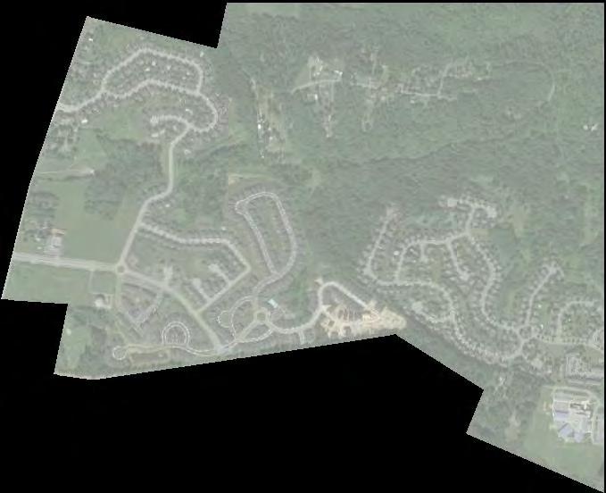
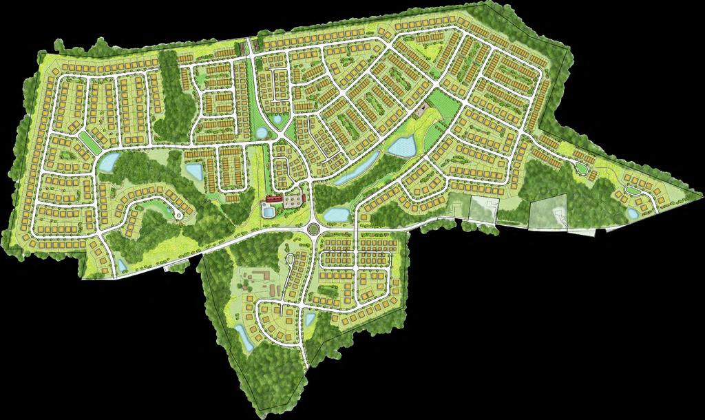
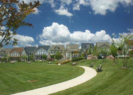
4 The Town of New Market Master Plan (the Plan) adopted in 2012 sets forth a clear vision for the future of the community based on Smart Growth principles that include among others: Encourage mixed land uses Incorporate compact building design Create housing opportunities and choices Create walkable communities Foster distinctive, attractive communities with a strong sense of place. According to the Plan, A one-sentence summary of New Market s visions and objectives is a desire to maintain a sustainable balance among New Markets economic, aesthetic, cultural, and historic elements. This notion is built on a commitment to change at a pace that preserves the Town s special quality of life, preserves its diversity of citizenry and architecture, preserves open space and the environment, as well as the town s historic character (page 17). In the interest of maintaining control of the development surrounding New Market and diversifying its tax base, the desire to grow at a responsible paced is stressed throughout the Plan to prevent..becoming a small town surrounded a larger county town (page 14). The proposed Neighborhood is located on the recently annexed Smith and Cline properties and is consistent with the goals set forth in the Master Plan for New Markets expansion and population growth. will consist of 925 Single Family Detached homes and Townhomes on 263 acres (±). Existing streams, wetlands, floodplains and forests form the green spine of the community. This combined with pocket parks, recreational areas and other open space areas will provide all residents with outdoor opportunities within walkable distance. The community will be bisected by a proposed Mussetter Road extended connecting to MD Rt. 75, thereby providing easy access to and from the community while alleviating traffic in the historic downtown area. With guidance from the Design Standards for New Market and oversight by the Historic District Commission / Architectural Review Committee (HDC/ARC), the development of will respect the rural and historic qualities of the Town while providing quality homes to accommodate the projected growth in the region. Introduction 2 Lot Design The design criteria used during the layout of the community, establish lot sizes and configurations while taking into consideration restrictions placed on individual residential lots. Subsequently, the size and configuration of each lot determines its use. As such, the criteria included in the lot design are the first step in introducing architectural and adjacency diversity within the community. Lot design criteria produce developments that are more sensitive to the environment, preserve open space, promote better site layout and opportunities for recreational areas, and result in energy-efficiency. They reduce the dominance of the vehicle and create pedestrian-oriented neighborhoods with walkable pathways and interconnected street systems. The criteria emphasize: protecting and celebrating the natural features of existing developments, developing safe and attractive neighborhoods, encouraging a range of lot sizes and housing types, building street networks for pedestrians, cyclists and cars, designing streets that are safe and attractive, and providing a high degree of opportunity for social interaction in the community. Lot Design Criteria Four criteria define the lot shape and size within the community. First, each lot should have sufficient size and shape to accommodate the construction of homes, meeting the requirements of established building, construction, housing and public health codes. Second, each lot should also be able to accommodate easements for all public and private utility services and facilities. Third, each lot should be individually connected to utilities and be independently metered. Finally, each lot should have public-street or access alley, public water and public sewer. Dwelling Units Fronting Green Spaces: Public / HOA open space throughout this neighborhood plays a key role in providing meaningful useable outdoor areas. Allowing residential units to front onto green spaces with public alley access accomplishes this goal. Many examples exist throughout the City of Frederick and Frederick County. Lots that are designed fronting onto an Public / HOA open space will have public alley access and is designed to provide direct public safety equipment to either the front or rear of the dwelling unit. Access for vehicles, utilities and emergency vehicles will be insured through the use of common area agreements or private easements.


5 Allowing residential units fronting onto common HOA neighborhood green spaces bolsters the character of the Town of New Market, creates a safe and attractive community and allows the community layout to be more sensitive to the environment. be provided with supporting documents demonstrating the typical design of the neighborhood Thoroughfares. Typical Thoroughfares cross sections are provided for the general design intent. Lot Size contains a variety of lot sizes in order to create a diverse streetscape and a sense of character. Lot Setbacks Dwellings are typically set back a uniform distance, with only minor fluctuations to provide visual relief in the neighborhood. The front semi-private yard is typically 10 to 15 feet in width from the street to the front of the dwelling, depending upon the character of the street. Porches may extend into the front yard not more than thirty (30) percent of the established front yard setback. Side yards are typically 4 to 6 feet in width, with a minimum of 10 feet between dwellings. Lots with driveways accessing streets require greater front yards. Side yards along streets, referred to as a secondary street frontage, should match the front yard of the adjoining lot that fronts the street. Free-standing garages and other secondary buildings should be placed towards the rear of the lot and are permitted to be closer to one or both sides of the side or rear lot lines. Lot Layout The following pages contain the lot criteria and architectural characteristics for each lot within. The lot types include a front-loaded, single family townhouse on a standard lot measuring wide by 90 feet deep; a single-family detached home on a standard lot measuring 50 wide by 100 deep served by alleys; and single-family detached homes on standard lots measuring 62 by 100 and 80 by 120. Corner lots will sometimes be increased in width between 5 to 10 feet to accommodate wrapped porches and other architectural elements. Local Neighborhood Streets Local Residential Streets within a neighborhood are intended to provide access equally to the pedestrian and the automobile. The Land Development Ordinance (LDO) Article IV, Section (a) Design Standards will be reviewed and approved by the Planning Commission for landscaping, lighting, walkways and road standards. During the Master Plan, Preliminary Plat and Improvement Plan review and approval process detail design and geometry will 3 Lot Standards
 Side Yard Setback: 5 Rear Yard Setback: 20 Maximum Building Height: 40 Minimum aggregate width of side")

6 Single Family Detached 80 Front Garage Minimum Lot Area: 8,000 s.f. Minimum Lot Width: 80 Front Yard Setback: 15 Street Side Yard Setback: 15 (Corner Lots only) Side Yard Setback: 5 Rear Yard Setback: 20 Maximum Building Height: 40 Minimum aggregate width of side yards to be 10 feet If attached to the principal structure, a one-story, open porch, with or without a roof may extend into a front yard not more than thirty (30%) of the existing front yard setback. Building height measured from average finished grade at building front to the midpoint of the roof. Projections such as bay window, chimneys, entrances, vestibules, balconies, eaves, and leaders may extend into any required setback not more than four (4) feet, provided that such projections (except eaves) are not over ten (10) feet in length and no closer than four (4) feet to any property or right-of-way line. If attached to the principal structure, a one-story open deck without a roof may extend into the required rear yard not more than twenty-five percent (25%) of the required setback. Accessory buildings, including detached garages, shall be located behind the front line of the principal dwelling structure, and shall be set back a minimum of five (5) feet from the side street lot line and rear property lines; and no less than four (4) feet from any side lot line. Surface drainage patterns shall be maintained when lots and homes are modified unless approved by the HOA. Lot Standards 4
 Side Yard Setback: 5 Rear Yard Setback: 20 Maximum Building Height: 40 Minimum aggregate width of side")

7 Single Family Detached 62 Front Garage Homes Minimum Lot Area: 6,000 s.f. Minimum Lot Width: 62 Front Yard Setback: 15 Street Side Yard Setback: 15 (corner lots only) Side Yard Setback: 5 Rear Yard Setback: 20 Maximum Building Height: 40 Minimum aggregate width of side yards to be 10 feet If attached to the principal structure, a one-story, open porch, with or without a roof may extend into a front yard not more than thirty (30%) of the existing front yard setback. Building height measured from average finished grade at building front to the midpoint of the roof. Projections such as bay window, chimneys, entrances, vestibules, balconies, eaves, and leaders may extend into any required setback not more than four (4) feet, provided that such projections (except eaves) are not over ten (10) feet in length and no closer than four (4) feet to any property or right-of-way line. If attached to the principal structure, a one-story open deck without a roof may extend into the required rear yard not more than twenty-five percent (25%) of the required setback. Accessory buildings, including detached garages, shall be located behind the front line of the principal dwelling structure, and shall be set back a minimum of five (5) feet from the side street lot line and rear property lines; and no less than four (4) feet from any side lot line. Surface drainage patterns shall be maintained when lots and homes are modified unless approved by the HOA. 5 Lot Standards
 Side Yard Setback: 5 Rear Yard Setback: 5 Maximum Building Height: 40 Minimum aggregate")

 are not over ten (10) feet in length and no closer than four (4) feet to any property or right-of-way line.")
 feet from the")
8 Single Family Detached 50 Alley Garage Homes Minimum Lot Area: 5,000 s.f. Minimum Lot Width: 50 Front Yard Setback: 5 Street Side Yard Setback: 5 (corner lots only) Side Yard Setback: 5 Rear Yard Setback: 5 Maximum Building Height: 40 Minimum aggregate width of side yards to be 10 feet If attached to the principal structure, a one-story, open porch, with or without a roof may extend into a front yard not more than thirty (30%) of the existing front yard setback. Building height measured from average finished grade at building front to the midpoint of the roof. Projections such as bay window, chimneys, entrances, vestibules, balconies, eaves, and leaders may extend into any required setback not more than four (4) feet, provided that such projections (except eaves) are not over ten (10) feet in length and no closer than four (4) feet to any property or right-of-way line. If attached to the principal structure, a one-story open deck without a roof may extend into the required rear yard not more than twenty-five percent (25%) of the required setback. Accessory buildings, including detached garages, shall be located behind the front line of the principal dwelling structure, and shall be set back a minimum of five (5) feet from the side street lot line and rear property lines; and no less than four (4) feet from any side lot line. Surface drainage patterns shall be maintained when lots and homes are modified unless approved by the HOA. Lot Standards 6
 Side Yard Setback: 4 (with 10 building separation) Rear Yard Setback: 10 Maximum Building Height: 40")

9 Townhouse - Front Garage Homes Minimum Lot Area: 1,200 s.f. Minimum Lot Width: Front Yard Setback: 15 Street Side Yard Setback: 10 (corner lots only) Side Yard Setback: 4 (with 10 building separation) Rear Yard Setback: 10 Maximum Building Height: 40 Minimum Front Parking Space: 18 (where provided) Minimum side to side separation of adjacent townhouse building groups to be 10 feet. Maximum number of attached homes without a break equals 8 unless the Planning Commission approves a limited number with 10 to address specific site constraints. If attached to the principal structure, a one-story, open porch, with or without a roof may extend into a front yard not more than thirty (30%) of the existing front yard setback. Building height measured from average finished grade at building front to the midpoint of the roof. Projections such as bay window, chimneys, entrances, vestibules, balconies, eaves, and leaders may extend into any required setback not more than four (4) feet, provided that such projections (except eaves) are not over ten (10) feet in length and no closer than four (4) feet to any property or right-of-way line. If attached to the principal structure, a one-story open deck without a roof may extend into the required rear yard not more than twenty-five percent (25%) of the required setback. Driveways to be a minimum of 18 between front of garage and back of sidewalk. Surface drainage patterns shall be maintained when lots and homes are modified unless approved by the HOA. Parking requirements may be met with a combination of on-lot and on-street parking spaces. 7 Lot Standards
 If attached to the principal structure, a one-story open deck without a roof may extend into the required rear yard not more than twenty-five percent (25%) of the required setback.")
10 Townhouse - Front Garage Homes (Cont.) If attached to the principal structure, a one-story open deck without a roof may extend into the required rear yard not more than twenty-five percent (25%) of the required setback. Driveways to be a minimum of 18 between front of garage and back of sidewalk. Surface drainage patterns shall be maintained when lots and homes are modified unless approved by the HOA. Parking requirements may be met with a combination of on-lot and on-street parking. Lot Standards 8
 Side Yard Setback: 10 Rear Yard Setback: 10 Accessory Building Setback: 5 from any lot line- (permitted in front yarld")

11 Community Pool Minimum Lot Area: +/- 1.5 acres Front Yard Setback: 10 Street Side Yard Setback: 10 (corner lots only) Side Yard Setback: 10 Rear Yard Setback: 10 Accessory Building Setback: 5 from any lot line- (permitted in front yarld along Mussetter Road frontage) Maximum Building Height: 40 Maximum Fence Height: 6 including fences within front yard Summary - bathhouse, clubhouse, HOA offices, with deck and indoor and outdoor gathering areas. Adjacent to the pool. On-site parking will be supplemented by on-street parking. Pathway and sidewalk connections for pedestrian access. Sited to be visible from Boyers Mill Road and Mussetter Road. The site has frontage on three public streets which creates 3 front yards. To achieve the design intent and to satisfy legal requirements for pool enclosures, several develoment stan dards (permitting accessory buildings in a front yard, height limit for a fence in a front yard, front yard setback for the primary building, and accessory structures) from the LDO are modified through this approval. Design to include a combination of modern and rustic elements to be approved by the ARC prior to issuance of building permits Projections such as bay window, chimneys, entrances, vestibules, balconies, eaves, and leaders may extend into any required setback not more than four (4) feet, provided that such projections (except eaves) are not over ten (10) feet in length and no closer than four (4) feet to any property or right-of-way line. 9 CommunityPool


12 Open Space and Recreation Areas A hierarchy of active and passive open spaces, pocket parks and recreational areas are located throughout providing easy access for all residents. At the top of the open space linear park network is a clubhouse with pool and athletic facilities centrally located off of Mussetter Rd. (extended) near the intersection with Boyers Mill Road providing equal access for all residents. This location is also adjacent to the linear network of passive open spaces created by stream valleys and natural features. Smaller recreational areas are located in the neighborhoods to the north and south of Mussetter Rd. (extended), as well as to the west of Boyers Mill Rd. Further down the Open Space hierarchy are pocket parks and tot lot s located within or near individual blocks, followed by passive landscape ESD features that manage stormwater while providing aesthetic features and wildlife habitat. Pedestrian Networks The design of encourages walking and biking by providing pedestrian walkways through the neighborhood providing connections between residences and open spaces. The placement of community greens and other open areas and the incorporation of existing natural features during the design of the neighborhood encourage outdoor activities and open-air interaction. The combined pedestrian / bike path associated with Mussetter Road will provide pedestrian access to the Town of New Market, The100 Acre woods and LOUYYA Fields. Neighborhood Commons 10
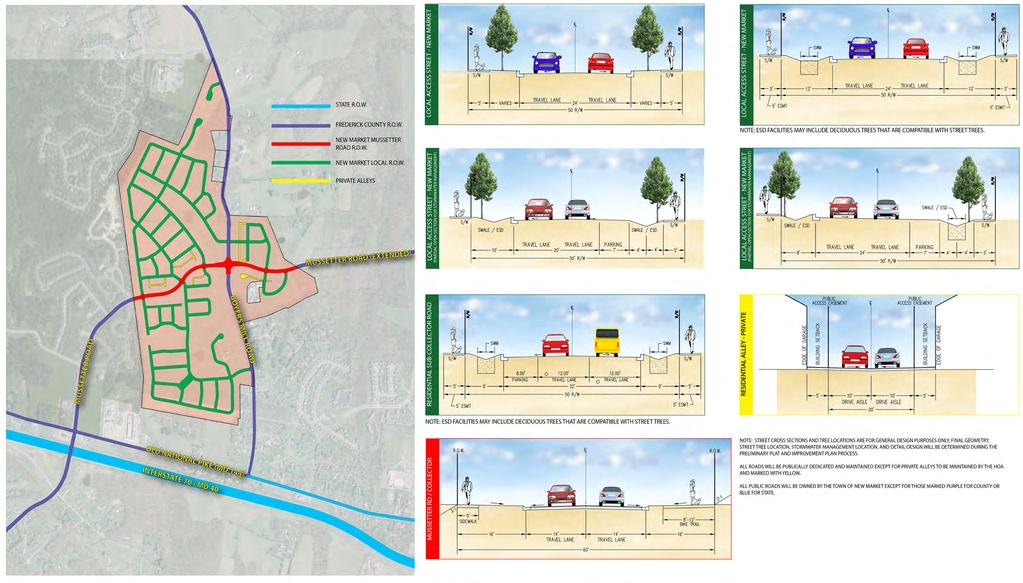
13 11 Thoroughfares
, the design of will utilize Environmental Site Design (ESD) / Low")


14 Environmental Site Design As required by the Maryland Department of the Environment (MDE) and stated in the New Market Master Plan (page 77), the design of will utilize Environmental Site Design (ESD) / Low Impact Development (LID) practices. According to the MD Stormwater Design Manual Section 5.0.1, ESD is a comprehensive design strategy for maintaining predevelopment runoff characteristics and protecting natural resources.. and relies on integrating site design, natural hydrology, and smaller controls to capture and treat runoff. According to LID is a comprehensive land planning and engineering design approach with a goal of maintaining and enhancing the predevelopment hydrologic regime of urban and developing watersheds. The two strategies are therefore one and the same. These strategies seek to reduce runoff and improve water quality by first reducing impervious coverage, utilizing pervious pavements and promoting tree coverage. Micro-Filtration practices such as bio-swales, gravel wetlands, raingardens, dry wells and wet ponds are then utilized throughout the site to capture and allow water to filter into the ground, thereby enhancing water quality. These facilities not only protect water quality but also benefit wildlife, control flooding and can serve as an aesthetic feature in the community. Typical ESD Details Bio-Swale Grass Swale Micro-Bio Rain Garden Environmental Site Design 12
City of Yelm. Tahoma Terra Final Master Plan Development Guidelines. Table of Contents
 City of Yelm Tahoma Terra Final Master Plan Development Guidelines Table of Contents Table of Contents... 1 Purpose... 2 Low Density Residential (R4-6)... 3 Moderate Density Residential (R6-10)... 5 Neighborhood
REZONING APPLICATION MPD SUPPLEMENT
 REZONING APPLICATION MPD SUPPLEMENT For Staff Use Only: DATE/TIMESTAMP: ZA# RECEIVED BY: The intent of the Master Planned District (MPD) designation is to allow flexibility in the design and construction
ARTICLE 13 STREETS General
 ARTICLE 13 STREETS 13.1 General Streets shall be designed to suit their functions. Many streets have purposes other than vehicular traffic. As an alternative to current N.C. Department of Transportation
ARTICLE 13 STREETS General
 ARTICLE 13 STREETS 13.1 General Streets shall be designed to suit their functions. Many streets have purposes other than vehicular traffic. As an alternative to current N.C. Department of Transportation
3700. OLD HOMOSASSA AREA REDEVELOPMENT PLAN STANDARDS. Aesthetic standards are mandatory for nonresidential projects only.
 3700. OLD HOMOSASSA AREA REDEVELOPMENT PLAN STANDARDS Aesthetic standards are mandatory for nonresidential projects only. 3701. PURPOSE AND INTENT The purpose of this section is to establish those supplemental
Section 9 NEIGHBORHOOD DESIGN
 Section 9 NEIGHBORHOOD DESIGN City of Lancaster Comprehensive Plan D u n k i n, S e f k o & A s s o c i a t e s, I n c. NEIGHBORHOOD DESIGN INTRODUCTION There are many ways in which a neighborhood can
Design Guidelines for Residential Subdivisions
 Design Guidelines for Residential Subdivisions Development Services 972-466-3225 cityofcarrollton.com This page intentionally left blank. Table of Contents Purpose... 1 Design Objectives... 1 Design Guidelines
LOW DENSITY RESIDENTIAL
 LOW DENSITY RESIDENTIAL Corner lots with coach houses to increase diversity, provide unity to the streetscape and increase eyes on the street. Garages and ancillary units accessed via rear lanes. Parking
B L A C K D I A M O N D D E S I G N G U I D E L I N E S for Multi-family Development
 B L A C K D I A M O N D D E S I G N G U I D E L I N E S for Multi-family Development Adopted June 18, 2009 This section of the Design and focuses on site planning and design guidance for new multi-family
understanding Green Infrastructure In Zoning
 understanding Green Infrastructure In Zoning Purpose Measurable standards can be adopted within municipal zoning codes, and subdivision and stormwater regulations, to promote a comprehensive approach to
Chapter RM MULTI FAMILY BUILDING ZONES
 Chapter 19.17 RM MULTI FAMILY BUILDING ZONES 19.17.010 Established 19.17.020 Primary Permitted Uses 19.17.030 Accessory Permitted Uses 19.17.040 Secondary Permitted Uses 19.17.050 Conditional Property
LANDSCAPING. Design. Development of the site shall not unreasonably impair the ability of adjoining properties to utilize solar energy.
 Landscape design is an integral component of Site Planning and Building. The current pattern of walkways, driveways and landscape elements such as fences, hedges, and retaining walls in the neighborhood
ARTICLE 6: Special and Planned Development Districts
 ARTICLE 6: Special and Planned Development Districts 6-10 Traditional Neighborhood Development (TND) District 6-10.10 Purpose and Intent The Traditional Neighborhood Development (TND) District provides
Planned Residential Neighborhoods Land Use Goals
 Planned Residential Neighborhoods Land Use Goals Issue: Guidelines that provide for diverse high quality residential areas that include a variety of housing styles and layouts are needed. Goal 1: Create
II. SINGLE FAMILY RESIDENTIAL
 II. SINGLE FAMILY RESIDENTIAL Castle Rock is made up of numerous individually built houses and subdivision tracts that have been developed during the past century. Some of the tracts are diverse in architectural
RESIDENTIAL PLANNED UNIT DEVELOPMENT / SUBDIVISION AND REZONING CONCEPT AND DEVELOPMENT STAGE PLAN SUBMITTAL NARRATIVE
 RESIDENTIAL PLANNED UNIT DEVELOPMENT / SUBDIVISION AND REZONING CONCEPT AND DEVELOPMENT STAGE PLAN SUBMITTAL NARRATIVE DEVELOPMENT TEAM DONEGAL SOUTH Maple Grove, Minnesota March 27, 2017 Applicant/Developer/Builder:
Community LID Workgroup Issue Paper #6
 Community LID Workgroup Issue Paper #6 Topic: Hard and Impervious Surface Coverage Limits Objective: Minimize the amount of hard and impervious surfaces in developments to allow more stormwater to infiltrate
Major Subdivision Sketch Plan Checklist
 This checklist provides specific requirements that are apart of the Sketch process. The entire process is described by the Huntersville Subdivision Review Process which details all the submittal and resubmittal
Asbury Chapel Subdivision Sketch Plan
 Asbury Chapel Subdivision Sketch Plan PART 1: PROJECT SUMMARY Applicant: NVR Inc. Project Size: +/- 76.13 acres Parcel Numbers: 02101112,02116101,02116112, 02116113 Current Zoning: Transitional Residential
Chapter PEDESTRIAN COMMERCIAL (PC) ZONING DISTRICT
 ZONING DISTRICT") Chapter 11-17 PEDESTRIAN COMMERCIAL (PC) ZONING DISTRICT Sections: 11-17-01 GENERAL PURPOSE 11-17-02 PERMITTED BUILDING TYPES 11-17-03 USES PERMITTED WITH DESIGN REVIEW 11-17-04 USES PERMITTED BY CONDITIONAL
Chapter 11-17 PEDESTRIAN COMMERCIAL (PC) ZONING DISTRICT Sections: 11-17-01 GENERAL PURPOSE 11-17-02 PERMITTED BUILDING TYPES 11-17-03 USES PERMITTED WITH DESIGN REVIEW 11-17-04 USES PERMITTED BY CONDITIONAL
DEFINITIONS AND RULES OF MEASUREMENT DEFINITIONS AND RULES OF MEASUREMENT 7-1
 7 DEFINITIONS AND RULES OF MEASUREMENT DEFINITIONS AND RULES OF MEASUREMENT 7-1 DEFINITIONS Abutting or Adjoining. Having a common boundary, except that parcels having no common boundary other than a common
TOP TEN LIST OF COMMUNITY CONCERNS REGARDING PROPOSED AMENDMENTS TO CHAPTER 42
 TOP TEN LIST OF COMMUNITY CONCERNS REGARDING PROPOSED AMENDMENTS TO CHAPTER 42 1. Extend the urban area to Beltway 8 in stages, over say a three-year period, prioritizing development in transit and declining
Improve Neighborhood Design and Reduce Non Point Source Water Pollution
 HOW TO Planning Guide Improve Neighborhood Design and Reduce Non Point Source Water Pollution This document was funded by a grant from the New Hampshire Coastal Program with funding from the National Oceanic
for Master Planned Development Framework Design Standards & Guidelines
 B L A C K D I A M O N D DE S I G N G U I D E L I N E S for Master Planned Development Framework Design Standards & Adopted June 18, 2009 Introduction and Purpose The Master Planned Development (MPD) Framework
FORMER CANADIAN FORCES BASE (CFB) ROCKCLIFFE SECONDARY PLAN. Official Plan Amendment XX to the Official Plan for the City of Ottawa
 ROCKCLIFFE SECONDARY PLAN. Official Plan Amendment XX to the Official Plan for the City of Ottawa") FORMER CANADIAN FORCES BASE (CFB) ROCKCLIFFE SECONDARY PLAN Official Plan Amendment XX to the Official Plan for the City of Ottawa 1 INDEX THE STATEMENT OF COMPONENTS PART A THE PREAMBLE PAGE Purpose...
FORMER CANADIAN FORCES BASE (CFB) ROCKCLIFFE SECONDARY PLAN Official Plan Amendment XX to the Official Plan for the City of Ottawa 1 INDEX THE STATEMENT OF COMPONENTS PART A THE PREAMBLE PAGE Purpose...
Throughout. square. (Crystal City Vision Plan 2050)
") 1: Terms related to the PSMP document 1 public space (see also public realm, civic space) An open space designated on the regulating plan, accessible to all, including Plazas, Mini Parks, and Neighborhoods
1: Terms related to the PSMP document 1 public space (see also public realm, civic space) An open space designated on the regulating plan, accessible to all, including Plazas, Mini Parks, and Neighborhoods
URBAN DESIGN BRIEF URBAN DESIGN BRIEF 721 FRANKLIN BLVD, CAMBRIDGE August 2018
 URBAN DESIGN BRIEF URBAN DESIGN BRIEF 721 FRANKLIN BLVD, CAMBRIDGE August 2018 DESIGN BRIEF CONTENTS PART A 1.0 INTRODUCTION 2.0 DESCRIPTION & ANALYSIS OF SITE CONTEXT 3.0 DESIGN CONSTRAINTS AND OPPORTUNITIES
Exhibit A. 8:9 Scuffletown Rural Conservation District
 Exhibit A 8:9 Scuffletown Rural Conservation District 8:9.1 Intent and Purpose The Scuffletown Rural Conservation (SRC) District is intended to provide for residential development that supports the development
AWH REPORT OF THE PLANNING AND DEVELOPMENT DEPARTMENT FOR APPLICATION FOR REZONING ORDINANCE TO PLANNED UNIT DEVELOPMENT
 AWH REPORT OF THE PLANNING AND DEVELOPMENT DEPARTMENT FOR APPLICATION FOR REZONING ORDINANCE TO PLANNED UNIT DEVELOPMENT MAY 8, 2014 The Planning and Development Department hereby forwards to the Planning
SYRINGA VALLEY SPECIFIC PLAN NARRATIVE
 SYRINGA VALLEY SPECIFIC PLAN NARRATIVE Introduction With this application, Pleasant Valley South LLC ( Pleasant Valley ) seeks the City of Boise s approval of a new Specific Plan Ordinance to be added
Appendix E: Illustrative Green Infrastructure Examples
 Appendix E: Illustrative Green Infrastructure Examples Integrating LID into San Francisco s Urban Landscape Figure E. High-density Residential Figure E. Low-density Residential Figure E. Mixed Use 7 Figure
SECTION UNIFIED DEVELOPMENT ORDINANCE SECTION Part 1 Ordinance. ARTICLE 1 Zoning Districts
 SECTION 1-100 UNIFIED DEVELOPMENT ORDINANCE SECTION 1-300 Part 1 Ordinance SECTION 1-100. Introduction. ARTICLE 1 Zoning Districts Crystal Lake strives to maintain a balance of various land uses for a
B. Blocks, Buildings and Street Networks
 B. Blocks, Buildings and Street Networks Figure IV.4 A rational block pattern with connected streets Introduction The single most important element in the physical and functional integration of mixed use
ARTICLE 2 FORM BASED DISTRICT STANDARDS
 ARTICLE 2 FORM BASED DISTRICT STANDARDS 2.1 INTENT 2.1.1 Intent It is the intent of these standards to: a. Provide the City of Rowlett with pedestrian-oriented/bicycle-friendly districts and neighborhoods
EXHIBIT B PROJECT NARRATIVE POULSBO MEADOWS
 EXHIBIT B PROJECT NARRATIVE POULSBO MEADOWS Name of Project: Poulsbo Meadows; A Planned Residential Development (PRD)/Plat Applicants Name: PBH Group LLC/Byron Harris PO Box 1010 Silverdale, WA 98038 Description
MIDTOWN MIXED-USE VILLAGE. TECHNICAL DATA SHEET COMPONENT C-1 FOR PUBLIC HEARING - PETITION NUMBER Project No RZ1.1. Issued.
 N MIDTOWN MIXED-USE VILLAGE TECHNICAL DATA SHEET COMPONENT C- FOR PUBLIC HEARING - PETITION NUMBER 04-00 Project No. 496 Issued Revised SCALE: " = 0' N 0 0 0 40 RZ. c GENERAL PROVISIONS: a. SITE LOCATION.
WAYNE GLEN (also known as the Richter Property) A model Low Impact Development (LID) community.
 A model Low Impact Development (LID) community.") WAYNE GLEN (also known as the Richter Property) A model Low Impact Development (LID) community. Sketch Plan Submission Tredyffrin Planning Commission i Meeting January 17, 2013 114 Forrest Avenue, Suite
WAYNE GLEN (also known as the Richter Property) A model Low Impact Development (LID) community. Sketch Plan Submission Tredyffrin Planning Commission i Meeting January 17, 2013 114 Forrest Avenue, Suite
PART 1: PROJECT SUMMARY. The application is Attachment A. The site plan is Attachment B.
 Belleterre Subdivision Sketch Plan Town Board 8.7.17 Belleterre Subdivision Sketch Plan PART 1: PROJECT SUMMARY Applicant: Bowman Development Project Size: +/- 20.85 acres Parcel Number: 01115104 and 01115121
Request Alternative Compliance to the prescribed criteria of the Oceanfront Resort District Form-Based Code. Staff Planner Kristine Gay
 Applicant/Owner Ocean Rental Properties, LLC Public Hearing April 13, 2016 City Council Election District Beach Agenda Item 1 Request Alternative Compliance to the prescribed criteria of the Oceanfront
TRANSIT ORIENTED DEVELOPMENT PINELLAS COUNTY MPO LIVABLE COMMUNITIES INITIATIVE PINELLAS COUNTY COMPREHENSIVE PLAN AMENDMENTS
 PINELLAS COUNTY MPO LIVABLE COMMUNITIES INITIATIVE MODEL LAND DEVELOPMENT CODE TRANSIT ORIENTED DEVELOPMENT PINELLAS COUNTY COMPREHENSIVE PLAN AMENDMENTS MPO Livable Communities Initiative Goal: Improve
DRAFT. 10% Common Open Space
 % OF CHARLOTTE IS CATEGORIZED AS A. LAND USES : Placeholder map displaying location of Place Type GOALS: Accommodate XX% of future growth. Provide a concentration of primarily commercial and civic activity
PINE CURVE REZONING. BACKGROUND Purchased as two parcels in 2001 and 2002
 BACKGROUND Purchased as two parcels in 2001 and 2002 WHAT THE PROJECT IS AND IS NOT A Rezoning establishes the land use standards for Annexed and Zoned Greater Downtown District Historic Center September
VILLAGE OF CLEMMONS PLANNING BOARD DRAFT STAFF REPORT. Single Family Residential, Townhomes
 VILLAGE OF CLEMMONS PLANNING BOARD DRAFT STAFF REPORT PETITION INFORMATION Docket # C-212 Staff Megan Ledbetter Petitioner(s) Peacehaven Development LLC Owner(s) Larry Jarvis, William Alexander and Peacehaven
g) "Minor repair" means repairs dealing primarily with nonstructural portions of the fence, as well as appearance.
 Minor repair means repairs dealing primarily with nonstructural portions of the fence, as well as appearance.") 6.2.4 FENCES, WALLS AND SCREENS: To protect the use and enjoyment of residential property by providing for the passage of air and light; to protect public welfare and safety by providing for the safe movement
6.2.4 FENCES, WALLS AND SCREENS: To protect the use and enjoyment of residential property by providing for the passage of air and light; to protect public welfare and safety by providing for the safe movement
Gold Line Bus Rapid Transit Transit Oriented Development (BRTOD) Helmo Station Area Plan
 Helmo Station Area Plan") Appendix F Gold Line Bus Rapid Transit Transit Oriented Development (BRTOD) Helmo Station Area Plan Introduction and Purpose of the Plan The Gold Line Bus Rapid Transit facility is an eleven-mile dedicated
Appendix F Gold Line Bus Rapid Transit Transit Oriented Development (BRTOD) Helmo Station Area Plan Introduction and Purpose of the Plan The Gold Line Bus Rapid Transit facility is an eleven-mile dedicated
Supplemental Design Guidelines
 Supplemental Design Guidelines 65 SUPPLEMENTAL DESIGN GUIDELINES As a supplemental reference to the project, the following diagrams are included to illustrate the site planning approaches that were followed
City of Vaughan Urban Design Guidelines for Infill Development in Established Low-Rise Residential Neighbourhoods
 City of Vaughan Urban Design Guidelines for Infill Development in Established Low-Rise Residential Neighbourhoods DRAFT - September 2016 Contents 1. Introduction 1 2. Policy Context 3 3. Characteristics
East Bayshore Road Neighbourhood
 East Bayshore Road Neighbourhood Northridge Property Management Urban Design Brief 3195 East Bayshore Road City of Owen Sound January 2016 East Bayshore Road Neighbourhood Northridge Property Management
Landscaping Standards
 CHAPTER 29 ARTICLE 403 29.403 Landscaping Standards Purpose: The purpose of this section is to protect and promote the public health, safety and general welfare by requiring landscaping in relation to
HE VISION. Building a Better Connected Place
 HE VISION Building a Better Connected Place WALK INTO THE FUTURE. Life in Cranberry, 2030 Here s what our residents told us they wanted to see in their community by 2030: The Cranberry of 2030 is a place
Urban Design Guidelines Townhouse and Apartment Built Form
 Urban Design Guidelines Townhouse and Apartment Built Form Town of Wasaga Beach Table of Contents 1. Introduction 1.1. Purpose 1.2. Urban Design Principles 1.3. Application of Guidelines 2. Site Design,
PINE CURVE REZONING. Property does not meet criteria for open space preservation and is not a candidate for a park
 PINE CURVE REZONING BACKGROUND Purchased as two parcels in 2001 and 2002 Annexed and Zoned Greater Downtown District Historic Center September 25, 2002 and October 7, 2002 WHAT THE PROJECT IS AND IS NOT
COUNTY OF PRINCE WILLIAM 5 County Complex Court, Suite 120 Prince William, Virginia (703) Metro Fax: (703)
 Metro Fax: (703)") COUNTY OF PRINCE WILLIAM 5 County Complex Court, Suite 120 Prince William, Virginia 22192-5308 (703) 792-6930 Metro 631-1703 Fax: (703) 792-5285 DEPARTMENT OF DEVELOPMENT SERVICES Wade A. Hugh Director
COUNTY OF PRINCE WILLIAM 5 County Complex Court, Suite 120 Prince William, Virginia 22192-5308 (703) 792-6930 Metro 631-1703 Fax: (703) 792-5285 DEPARTMENT OF DEVELOPMENT SERVICES Wade A. Hugh Director
Residential Design Standards Stakeholders Meeting
 Residential Design Standards Stakeholders Meeting CHARLOTTE-MECKLENBURG PLANNING DEPARTMENT JULY 29 TH, 2008 Agenda Introductions Housekeeping Recap of 1 st meeting Presentation-Planning Policies and Regulations
3.1 community vision. 3.3 required plan elements
 Chapter 3 Community Form 3.1 community vision 3.2 Parks & landscaping concepts 3.3 required plan elements D R A F T 20 Community Form Chapter 3 3.0 Community form 3.1 community vision The Specific Plan
ARTICLE IV: DEVELOPMENT STANDARDS 404 MASTER PLANNING
 IV 13 404 MASTER PLANNING Master Planning through the Site Analysis (Master Planning Site Analysis) or Planned Development (Master Planning Planned Development) is provided to encourage development which
CITY OF UNIVERSITY PLACE
 CITY OF UNIVERSITY PLACE DESIGN STANDARDS AND GUIDELINES FOR SMALL LOT AND MULTIFAMILY DEVELOPMENT Exhibit A Adopted by Reference in UPMC Chapter 19.53 Planning and Community Development Department TABLE
I. Introduction. Prior Approvals
 Statement of Justification First National Bank 19790 Crystal Rock Drive, Germantown, Maryland Application for Site Plan and Limited Preliminary Plan Amendment I. Introduction DPH Architecture, for First
Eastcreek Farm. Planned Development Standards September, 2014
 Eastcreek Farm Planned Development Standards September, 2014 ekfarm Contents 01. General Standards 02. Residential Development Standards 03. Architectural Design Standards 04. Landscape Design Standards
Chapter Purpose and Intent. 7.2 Applicability. 7.3 General Provisions RECREATIONAL OPEN SPACE
 Chapter 7. RECREATIONAL OPEN SPACE 7.1 Purpose and Intent The intent of this Chapter is to provide for centrally located, unencumbered land as neighborhood recreational open space and not to permit the
DESIGN STANDARDS AND GUIDELINES FOR SMALL LOT AND MULTI-FAMILY DEVELOPMENT
 CITY OF FIRCREST DESIGN STANDARDS AND GUIDELINES FOR SMALL LOT AND MULTI-FAMILY DEVELOPMENT Adopted by Reference in FMC Chapter 22.63 October 13, 2015 Planning and Building Department TABLE OF CONTENTS
PLANNED UNIT DEVELOPMENT PUD For The Proposed Antietam Subdivision Escambia County, Florida. Introduction
 PLANNED UNIT DEVELOPMENT PUD For The Proposed Antietam Subdivision Escambia County, Florida Introduction The project is located in Escambia County approximately 0.75 + miles north of the US Highway 90,
Duplex Design Guidelines
 Duplex Design Guidelines Adopted by Council May 29, 2006 Prepared By: Table of Contents 1.0 Application and Intent 1 2.0 Areas of Application 2 3.0 Design Principles 3 4.0 Design Guidelines 4 4.1 Site
Importance of townhouse design
 Importance of townhouse design Townhouses in the past Townhouses in the past Montco2040 Goals Townhouse Trends in Montco Attached and multifamily housing have become the dominant form of built housing,
Conservation Development
 Acknowledgements RIDEM: Scott Millar Anthony Lachowicz-Planning and Zoning Consultant Director of Planning 1 : a creative land use technique that allows a community to guide growth to the most appropriate
MONTGOMERY COUNTY PLANNING DEPARTMENT THE MARYLAND-NATIONAL CAPITAL PARK AND PLANNING COMMISSION
 MONTGOMERY COUNTY PLANNING DEPARTMENT THE MARYLAND-NATIONAL CAPITAL PARK AND PLANNING COMMISSION MCPB Item No. Date: 12-10-15 Leisure World Clubhouse II Addition Fitness Center, Limited Site Plan Amendment
ARTICLE V PLANNED UNIT DEVELOPMENT DISTRICT
 ARTICLE V PLANNED UNIT DEVELOPMENT DISTRICT A. Purpose and Objective The Planned Unit Development (PUD) procedure provides a flexible land use and design regulation through the use of performance criteria
ST. MARY S SOIL CONSERVATION DISTRICT (SMSCD) AND DPW&T CONCEPT EROSION AND SEDIMENT CONTROL AND STORMWATER MANAGEMENT GUIDELINES AND CHECKLIST
 AND DPW&T CONCEPT EROSION AND SEDIMENT CONTROL AND STORMWATER MANAGEMENT GUIDELINES AND CHECKLIST") St. Mary s Soil Conservation District 26737 Radio Station Way, Suite B Leonardtown, MD 20650 Phone: 301-475-8402 ext. 3 Fax: 301-475-8391 www.stmarysscd.com St. Mary s County Government Department of Public
St. Mary s Soil Conservation District 26737 Radio Station Way, Suite B Leonardtown, MD 20650 Phone: 301-475-8402 ext. 3 Fax: 301-475-8391 www.stmarysscd.com St. Mary s County Government Department of Public
R E S O L U T I O N. Single-Family Residence/ Church. 2,488 sq. ft. 2,488 sq. ft. Area Parking Required: Church
 R E S O L U T I O N WHEREAS, the Prince George s County Planning Board is charged with the approval of Detailed Site Plans pursuant to Part 3, Division 9 of the Zoning Ordinance of the Prince George s
Clair-Maltby Community visioning
 Clair-Maltby Community visioning workshop #1 Summary April 27th, 2017 Table of Contents INTRODUCTIon 1 PURPOSE 1 CONSULTATION STRUCTURE 2 PARTICIPANT FEEDBACK 3 VISIONING EXERCISE 8 ONLINE SURVEY RESULTS
3. VISION AND GOALS. Vision Statement. Goals, Objectives and Policies
 Vision Statement Queen Creek s interconnected network of parks, trails, open spaces and recreation opportunities provide safe and diverse activities and programs that sustain its unique, small town, equestrian
Narcoossee Roadway Corridor
 Community Meeting Narcoossee Roadway Corridor April 5, 2012 Meeting Agenda Purpose of Meeting Continuation of Study Update Process (Previous Meetings Oct. & Nov., 2011) Tonight s Objective Review Proposals
CITY OF ZEELAND PLANNING COMMISSION
 APPLICATION FOR SITE PLAN REVIEW AND SPECIAL LAND USE Date City Official App. Filing Fee Rec'd ($350) NOTE TO APPLICANT: Please submit this application for Site Plan Review along with twenty (20) copies
 Villa Vizcaya PUD Amendment No. 3 4 April 16, 2008 May 29, 2015 Presented to: City of Port St. Lucie Planning and Zoning Department 121 SW Port St. Lucie Boulevard Port St. Lucie, Florida 34984 Exhibit
URBAN DESIGN BRIEF. 2136&2148 Trafalgar Road. Town of Oakville
 URBAN DESIGN BRIEF 2136&2148 Trafalgar Road Town of Oakville Prepared By: METROPOLITAN CONSULTING INC For 2500674 Ontario Inc November 2016 TABLE OF CONTENTS Page No. 1.0 Introduction/Description of Subject
SECTION TWO: Overall Design Guidelines
 SECTION TWO: Overall Design Guidelines This section provides overall design principles and guidelines for the Gardnerville Mixed-use Overlay. They provide criteria for mixed-use places consisting of residential,
ARTICLE 9: Landscaping
 ARTICLE 9: Landscaping 9-10 Legislative Intent The purpose of this Article is to regulate the planting and preservation of landscape materials; to facilitate the creation of an attractive and healthy environment;
PLANNING COMMISSION. Agenda Item # 6.
 PLANNING COMMISSION Agenda Item # 6. LAND DEVELOPMENT CODE AMENDMENT Planning Commission: October 5, 2016 Case: LDC-6-1016 Staff Contact: Eryn K. Moller; eryn.moller@wilmingtonnc.gov 910-341-4695 Staff
Description of Preferred Alternative
 Chapter 2 Description of Preferred Alternative 2.1 Introduction This chapter of the programmatic Sammamish Town Center Sub-area Plan Final EIS provides a more detailed description of the Preferred Alternative
Request Change in Nonconformity. Staff Recommendation Approval. Staff Planner Jonathan Sanders
 Applicant & Owner Public Hearing April 11, 2018 City Council Election District Beach Agenda Item 5 Request Change in Nonconformity Staff Recommendation Approval Staff Planner Jonathan Sanders Location
CITY OF PORTSMOUTH PLANNING DEPARTMENT. MEMORANDUM To: From:
 CITY OF PORTSMOUTH PLANNING DEPARTMENT MEMORANDUM To: From: Subject: Date: Planning Board Juliet T.H. Walker, Planning Director Jillian Harris, Planner 1 Staff Recommendations for the August 23, 2018 Planning
Chesapeake Bay Critical Area Conservation Plan
 The Maryland-National Capital Park and Planning Commission Prince George s County Planning Department Development Review Division 301-952-3530 Note: Staff reports can be accessed at www.mncppc.org/pgco/planning/plan.htm.
The Baileys Planning District portion of the Comprehensive Plan contains site design recommendations for both the Baileys Crossroads Community
 The Baileys Planning District portion of the Comprehensive Plan contains site design recommendations for both the Baileys Crossroads Community Business Center and the Seven Corners Community Business Center.
CITY PLANNING COMMISSION AGENDA ITEM: C STAFF: ROBERT TEGLER FILE NO: CPC PUD QUASI-JUDICIAL
 CPC AGENDA June 8, 2006 Page 37 CITY PLANNING COMMISSION AGENDA ITEM: C STAFF: ROBERT TEGLER FILE NO: CPC PUD 05-294 - QUASI-JUDICIAL PROJECT: APPLICANT: OWNER: PARKWOOD AT WOLF RANCH NASS DESIGN ASSOCIATES
Neighborhood Districts
 NEIGHBORHOOD DISTRICTS SEVEN MAIN DISTRICTS Neighborhood Districts While the Development Plan provides a broad-scale overview of the neighborhood, this section focuses on uses and relationships at the
City of Fort Lupton Administrative Site Plan Process
 City of Fort Lupton Administrative Site Plan Process Purpose The Site Plan process is meant to promote orderly and sound development standards as they apply to the City. These site development standards
CHAPTER 11 SITE DESIGN AND LOW IMPACT DEVELOPMENT
 CHAPTER 11 SITE DESIGN AND LOW IMPACT DEVELOPMENT Source: City of Bend Chapter Organization 11.1 Purpose... 11-1 11.2 Applicability... 11-1 11.3 Low Impact Development Overview... 11-2 11.3.1 Key Strategies...
CHAPTER 3 VISION, GOALS, & PLANNING PRINCIPLES. City of Greensburg Comprehensive Plan. Introduction. Vision Statement. Growth Management Goals.
 CHAPTER 3 VISION, GOALS, & PLANNING PRINCIPLES Introduction The Greensburg Comprehensive Plan is intended as a working community document. A combination of long and short-term goals, this document is intended
Dwelling Units Max 12 dwelling units per acre/min 8 dwelling units per acre. Development Mix 80% non residential/20% residential
 13. OSTEEN LOCAL PLAN Background: The Osteen Local Plan area is located in southwest Volusia County along the SR 415 corridor between Lemon Bluff Road and Acorn Lake Road and includes 3,990 acres. The
Low Impact Development. Charlene LeBleu Auburn University Landscape Architecture (334)
") Low Impact Development Charlene LeBleu Auburn University Landscape Architecture leblecm@auburn.edu (334) 844-0192 What is Low Impact Development? Infiltrate Filter Store Evaporate Detain An innovative
Low Impact Development Charlene LeBleu Auburn University Landscape Architecture leblecm@auburn.edu (334) 844-0192 What is Low Impact Development? Infiltrate Filter Store Evaporate Detain An innovative
Gruene River Place PDD CONCEPT PLAN AND DEVELOPMENT STANDARDS
 Gruene River Place PDD CONCEPT PLAN AND DEVELOPMENT STANDARDS GRUENE RIVER PLACE PLANNED DEVELOPMENT DISTRICT As per Section 3.5, Chapter 144 of the City s Zoning Ordinance To: The Planning & Zoning Commission
Required yards shall be horizontally unobstructed except as follows:
 ARTICLE IV: DEVELOPMENT STANDARDS 418 SETBACKS IV 111 418 SETBACKS 418 1 Obstruction in Required Yards Required yards shall be horizontally unobstructed except as follows: 418 1.1 Cornices, eaves, belt
D1 September 11, 2013 Public Hearing APPLICANT:
 D1 September 11, 2013 Public Hearing APPLICANT: BEACH MUNICIPAL FEDERAL CREDIT UNION PROPERTY OWNER: SISTERS II, LLC STAFF PLANNER: Karen Prochilo REQUEST: Conditional Change of Zoning (AG-2 Agriculture
Application Number: SD Project Name: Walton Farms Preliminary Subdivision (acting as Master Plan)
") STAFF REPORT Town of Clayton Planning Department 111 E. Second Street, Clayton, NC 27520 P.O. Box 879, Clayton, NC 27528 Phone: 919-553-5002 Fax: 919-553-1720 Planning Board May 22, 2017 Application Number:
STAFF REPORT Town of Clayton Planning Department 111 E. Second Street, Clayton, NC 27520 P.O. Box 879, Clayton, NC 27528 Phone: 919-553-5002 Fax: 919-553-1720 Planning Board May 22, 2017 Application Number:
Obey Creek July 17, Vicinity Map. Concept Plan Submittal. No
 15/501 Fordham Blvd. 15/501 By-Pass To Downtown Chapel Hill Vicinity Map 0 1000 2000 FT Arlen Park DR. Bennett Road Mt. Carmel Church Rd. Southern Village Parkside Circle Market St. 15/501 Founder's Ridge
Part 9 Specific Land Uses - Housing on Small and Narrow Lots
 19 HOUSING ON SMALL AND NARROW LOTS This section of the DCP applies where development for the purpose of a dwelling house, attached dwellings, or semi-detached dwellings is or are proposed in the R2 Low
Article 7.05 Manufactured Home Park Districts
 Article Manufactured Home Park Districts.01 Intent The purpose of the MHP Manufactured Home Park District is to give recognition to the fact that manufactured homes can provide satisfactory living conditions
Complete Neighbourhood Guidelines Review Tool
 Complete Neighbourhood Guidelines Review Tool Prepared By: City of Regina Planning Department October 2014 Page 1 of 14 Community Development Review Checklist for Secondary Plans and Concept Plans The
General Location Courtyard at LMH Final Development Plan and Final Plat
 R-1 LEYDEN RIDGE LOMA RIDGE LOBDELL R-3 MILLER PARKWAY LAUSSAC Subject Property R-3 LOCHENSHIRE LESMER R General Location Courtyard at LMH Final Development Plan and Final Plat ¹ 230 115 0 230 Feet Airport
IV. Development in the Rural Overlay District
 Intracoastal Waterway Route 17 Route 168 Great Dismal Swamp VIRGINIA NORTH CAROLINA IV. Development in the Rural Overlay District IV-1 Route 17 in Chesapeake s Rural Overlay District affords distant views