DACORUM GOLDEN PARSONAGE Great Gaddesden Brief Description Principal Building: Approach: Stable block other utilitarian buildings: Walled Garden:
|
|
|
- Leona Gray
- 5 years ago
- Views:
Transcription
1 HERTFORDSHIRE GARDENS TRUST LOCAL LIST: DACORUM Present Name of Site GOLDEN PARSONAGE Historic Name (if known) Parish/Town Great Gaddesden National Grid Reference of Principal Building: TL Present Area (approximate) In 1836 Golden Parsonage was advertised for lease and the particulars noted a park of 46 acres. In Herts Archaeology and History Vol the acreage is given as 148 acres. Brief Description Significant park and gardens in 18 th Century to the present day though the park is now mostly ploughed. Origins of the house and grounds are 16 th Century but extant features are principally 18 th Century. Principal Building: Country house and attached garden walls on the north east. Present house begun in 1720s by Henshaw Halsey which seems to have originated as a new north western wing to the older house of the 1660s, just three bays wide and with the finest architectural details on the south east facing the gardens. Soon after completion, this block was extended by a further two bays to the north west. After demolition of most of the older, existing house, this new virtually square building became the main residence. Approach: Running south west from Gaddesden Row along a hedge and tree drive reaching the main entrance which faces NNW where there is an inscription beside the porch outside dated Stable block/other utilitarian buildings: A long brick wall of 56 courses high, each course being 7.5cm runs SW to NE adjacent to the SE front of the house and bears evidence of garden buildings at each end with windows punched through at the eastern end to overlook a lawn and the smaller of 2 walled garden enclosures. The building at the western end seems to have been erected at the same time as alternations made to the house by Henshaw Halsley in the 1720s for its walls are decorated with the same vitrified headers as the pilasters of that new build. Windows of both buildings have been block and the buildings themselves taken down but enough remains to suggest two imposing greenhouses or orangeries looking out across the main area of gardens. Walled Garden: 100 metres NE of the house and described as trapezoid and constructed after 1787 using bricks from the 1760s demolished house's walled gardens which were built SE of that house. Walls 3ft high, lower parts of narrow 16 th or 17 th Century red brick English bond, upper parts 18 th Century red brick Flemish bond. Pleasure grounds and ornamental features extending into the wider park: An estate map in 1717 for Henshaw Halsey shows the house surrounded by a series of rectangular enclosures bordered with trees. The main garden is to the south and east of the house and terminates in an area of woodland described as The Grove. Relict features are a series of three rectangular ponds, possibly semi-ornamental fish ponds, joined together to form a single rectangular area of water in the late 19 th Century. Some 25 metres to the east and parallel with the ponds is a low raised terrace on which still grows a single large lime tree, the survivor of an avenue of trees. To the north east of the terrace is another area of water, a substantial ornamental canal of early 18 th Century date, flanked by a walk the remains of a three-meter Golden Parsonage 1/5
2 wide terrace can still be seen, cut into the slope of the ground on its western side. A tree covered mound, some five meters in height stands about 100 metres to the east of these features and some 250 metres from the house, constructed early 18 th Century at a time when there was an increasing interest in extended prospects. Lastly, extending south westwards from and almost on the same alignment as the fishponds, is a fine avenue of lime trees which today continues for some 600 metres as far as London Wood. Some originals survive with girths in excess of 5 metres suggesting a planting date of 1720s. The feature is not aligned on the house or on a point near it and nor did it ever line a major approach to the house. Drury and Andrews' county map of 1866 and Bryant's map of 1822 do however show that there was originally another avenue, running parallel and some distance to the north west which was apparently aligned on the house. However it appears this surviving avenue was intended simply to provide a walk or a ride extending out from the Grove and associated garden features into the wider landscape of the estate. Important people associated with site: Resident: Sir John Halsey (d1670) Master of Chancery, Thomas Halsey sheriff county 1697 and MP (between 1685 and 1713). Architect: Designer: Assessment of significance. Ancient and complex site with many relict features of 18 th landscape park which merits further investigation. It has always been linked with the neighbouring Gaddesden Place estate (q.v.), owned by the same family Principal Uses: Residential and farming on estate Public Access/Rights of Way: FP 23, 32, 34 Designations: (e.g. Scheduled Ancient Monuments, Conservation Area, Listed Buildings, EH Register of Historic Parks & Gardens, Tree Preservation Orders, SSSIs, Nature Reserve, National Trust, County Wildlife Site, etc) House and garden walls attached on north-east Grade II*, Great Gaddesden Area of Archaeological Significance Area of Outstanding Natural Beauty Rural Area Landscape Character Area: 124 Gaddesden Row Sources of information: Original report of Hertfordshire Gardens Trust in ACC 3898 in Hertfordshire Archives and Local Studies Site visited by: Hertfordshire Gardens Trust Date: 2000 Golden Parsonage 2/5


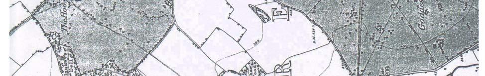
3 Ordnance Survey 2 nd Edition Sheet XXXIII 1883/4. Scale 6 :1 mile Golden Parsonage 3/5
4 Ordnance Survey 2 nd Edition Sheet XXXIII 1883/4. Scale 6 :1 mile Showing Relationship of Golden Parsonage and Gaddesden Place Golden Parsonage 4/5


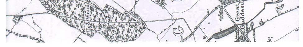
5 A Mansion B 17C Wall D Lime Avenue c E 3 Fishponds joined to form 1 in late 19C F Low raised Terrace with relict lime of early avenue G Early 18C canal H Tree covered mound possibly an 18C viewing mount Relict landscape features at Golden Parsonage Remains of early 18c Canal Sweet Chestnuts Lime Avenue Golden Parsonage 5/5
CGT visit to Godolphin 11 th May 2016
 CGT visit to Godolphin 11 th May 2016 The garden at Godolphin Is one of Cornwall s most important medieval gardens and is on the national Register of Parks and Gardens as II*. The Register summary states
Leicestershire and Rutland Gardens Trust Walled Kitchen Garden Register
 Leicestershire and Rutland Gardens Trust Walled Kitchen Garden Register Name of House: East Langton Grange Address: East Langton Grange Back Lane East Langton Market Harborough LE16 7TB Ownership: Private
Proposed Retirement Village Cole Green Way, Hertford. Archaeology Statement
 RETIREMENT LIVING MADE BETTER Proposed Retirement Village Cole Green Way, Hertford Archaeology Statement Woodlands Retirement Village RETIREMENT LIVING MADE BETTER Retirement Living Made Better Archaeology
National Character Area 70 Melbourne Parklands
 Summary The are a landscape of rolling farmland, parkland and woodland on the northern flanks of the ridge between Burton upon Trent and Swadlincote. The land slopes down to the River Trent, which borders
Present Area (approximate) School 60 Acres
 School 60 Acres") HERTFORDSHIRE GARDENS TRUST LOCAL LIST: DACORUM Present Name of Site BEECHWOOD Historic Name (if known) St Giles in the Wood Parish/Town Markyate National Grid Reference of Principal Building: TL045 145
HERTFORDSHIRE GARDENS TRUST LOCAL LIST: DACORUM Present Name of Site BEECHWOOD Historic Name (if known) St Giles in the Wood Parish/Town Markyate National Grid Reference of Principal Building: TL045 145
Broad Oak Farm, Sweechgate, Broad Oak, Canterbury, Kent
 Broad Oak Farm, Sweechgate, Broad Oak, Canterbury, Kent Broad Oak Farm Sweechgate, Broad Oak, Canterbury, Kent CT2 0QR A fine family home set in a large, established garden within easy reach of Canterbury.
Understanding Historic Parks and Gardens in Buckinghamshire
 Understanding Historic Parks and Gardens in Buckinghamshire The Buckinghamshire Gardens Trust Research & Recording Project Denham Grove (formerly Durdent Court/ Tile House) April 2016 Bucks Gardens Trust
Historical Value As evidence of Quaker heritage in Wells extending over three hundred years, the meeting house has high historical value.
 Friends Meeting House, Wells-next-the-Sea Quaker Yard, Church Street, Wells-next-the-Sea, Norfolk, NR23 1HZ National Grid Reference: TF 91978 43092 Statement of Significance The building has high significance
& Local History Society
 Ampthill & District Archaeological & Local History Society The Search for a lost Moat A Resistance Survey of the Old House at Wrest TL 092354 Kevan J. Fadden Michael J. B. Turner K J Fadden and M J B
Persimmon Homes Thames Valley Date received: 2 nd April week date(major): 2 nd July 2014 Ward: Nascot
: 2 nd July 2014 Ward: Nascot") PART A Report of: DEVELOPMENT MANAGEMENT SECTION HEAD Date of Committee: 26 th June 2014 Site address: Rounton, 28, Nascot Wood Road Reference Number: 14/00497/REM Description of Development: Reserved
PART A Report of: DEVELOPMENT MANAGEMENT SECTION HEAD Date of Committee: 26 th June 2014 Site address: Rounton, 28, Nascot Wood Road Reference Number: 14/00497/REM Description of Development: Reserved
Leicestershire and Rutland Gardens Trust Walled Kitchen Garden Register
 Leicestershire and Rutland Gardens Trust Walled Kitchen Garden Register Name of House: Address: Brooksby Hall (now Brooksby Melton College) Brooksby, Melton Mowbray Leicestershire LE14 2LJ Ownership: Private
Lancaster Conservation Area Appraisal. Character Area 8. Cathedral
 Lancaster Conservation Area Appraisal Character Area 8. Cathedral March 2013 118 3.8 Character Area 8. Cathedral 3.8.1. Definition of Special Interest "This character area is distinctive for the fine group
Appendix 1: Site Inventory Form
 Appendix 1: Site Inventory Form Wapsi Valley Archaeology, Inc. Anamosa, IA 56 X Cemetery Washington 83 24 2 NE X 1 5 approx. 200 approx. 201 unknown unknown Historic Resources Evaluation: 07A: Cemetery
ENVIRONMENTAL INVENTORY
 Hungarton Neighbourhood Plan ENVIRONMENTAL INVENTORY Sites scoring 25/36 or more (70%) are judged to be the most important environmental and community sites and are proposed as Local Green Space. Other
Quaker Meeting House, Ipswich. 39 Fonnereau Road, Ipswich, Suffolk, IP1 3JH. National Grid Reference: TM Statement of Significance
 Quaker Meeting House, Ipswich 39 Fonnereau Road, Ipswich, Suffolk, IP1 3JH National Grid Reference: TM 16326 44954 Statement of Significance The building has medium heritage significance as an example
The Kent Compendium of Historic Parks and Gardens for Medway. Parkwood Green Rainham
 The Kent Compendium of Historic Parks and Gardens for Medway Parkwood Green Rainham March 2014 Parkwood Green Rainham TABLE OF CONTENTS LOCATION BRIEF HISTORY SITE DESCRIPTION LISTING STATUS CONCLUSION
Internship Role Profile Visitor Experience Development Intern
 Internship Role Profile Visitor Experience Development Intern Overview of the role 2016 is a particularly exciting year at Fountains Abbey and Studley Royal in which we are launching many new initiatives
Parish Derry Slopes ITM Coordinates ; NG Coordinates C House B1 and farm buildings B2; Registered Garden L061
 Asset Ref No. HB/01/27/018A-C, Ballyarnett & Farm; Registered Historic Garden L061 Heritage Type Location Protection Status Condition Ownership (if known) Built Post-Medieval house & farm OS 6-inch map
Butler s Farm, St Mary Bourne, Hampshire
 Butler s Farm, St Mary Bourne, Hampshire On the market for the first time in 47 years Lying on a quiet country lane, a 17th century Grade II listed farmhouse, beautifully maintained, with a magnificent
Appraisal of proposed alterations to the boundary of Helmsley Conservation Area
 Appraisal of proposed alterations to the boundary of Helmsley Conservation Area Elmslac Road: Elmslac Road was constructed in the early 1950s in two or three stages by the Helmsley Rural District Council.
Historical value The building is a rare example of a small, little altered meeting house of the eighteenth century. It has high historical value.
 Friends Meeting House, Wallingford 13 Castle Street, Wallingford, Oxfordshire, OX10 8DL National Grid Reference: SU 60702 89627 Statement of Significance The meeting house is a small brick building of
Built in 1984, the meeting house is the third meeting house on a site acquired in 1668 as a burial ground. The building has low heritage significance.
 Friends Meeting House, Reigate 47 Reigate Road, Reigate, Surrey, RH2 0QT National Grid Reference: TQ 26184 50219 Statement of Significance Built in 1984, the meeting house is the third meeting house on
NATIONAL REGISTER OF HISTORIC PLACES MULTIPLE PROPERTY DOCUMENTATION FORM CONTINUATION SHEET ASSOCIATED PROPERTY TYPES
 Section F, Page 1 ASSOCIATED PROPERTY TYPES Six common property types are identified with the 48 cemeteries surveyed in the Town of Southampton. These six property types are identified as being associated
Friends Meeting House, Norwich. Upper Goat Lane, Norwich, Norfolk, NR2 1EW. National Grid Reference: TG Statement of Significance
 Friends Meeting House, Norwich Upper Goat Lane, Norwich, Norfolk, NR2 1EW National Grid Reference: TG 22802 08656 Statement of Significance The meeting house has exceptional heritage significance as a
10. East Dulwich East Dulwich Area Vision
 10. 10.1. Area Vision 10.1.1. is: A predominantly residential area characterised by mostly medium density housing, including many family homes. Many parts of have retained historic character and it includes
Sandall Park, Doncaster
 Sandall Park, Doncaster History The site was marked as the Sandall Brick and Tile Works on the 1854 and 1892 OS maps. It appeared on the 1906, 1930 and 1937 1:2500 maps similarly marked but also disused.
Historic England Advice Report 26 August 2016
 Case Name: Kingsland Castle Case Number: 1435892 Background Historic England has been asked to review the scheduling for Kingsland Castle. The land on which the monument lies is understood to be for sale.
PENVENTINUE MANOR FARM FOWEY, CORNWALL
 PENVENTINUE MANOR FARM FOWEY, CORNWALL PENVENTINUE MANOR FARM PENVENTINUE LANE, FOWEY, CORNWALL An extremely impressive and beautifully presented restored, 17th Century detached former farmhouse with
HERITAGE STATEMENT AND IMPACT ASSESSMENT HILLBARK FARMHOUSE FRANKBY
 HILLBARK FARMHOUSE HERITAGE STATEMENT AND IMPACT ASSESSMENT HILLBARK FARMHOUSE FRONT ENTRANCE CONTENTS Executive summary 1.0 INTRODUCTION 1.1. Background to the report 1.2. Purpose of the Report 2.0 SIGNIFICANCE
OAK LODGE INVERESK, MIDLOTHIAN
 OAK LODGE INVERESK, MIDLOTHIAN OAK LODGE 14 INVERESK VILLAGE MUSSELBURGH MIDLOTHIAN EH21 7TE A CHARMING GEORGIAN HOUSE IN CONSERVATION VILLAGE JUST 7 MILES EAST OF EDINBURGH Hallway, Drawing Room, Dining
The Cedars THE CAUSEWAY 8 GREAT HORKESLEY 8 COLCHESTER
 The Cedars THE CAUSEWAY 8 GREAT HORKESLEY 8 COLCHESTER The Cedars The Causeway, Great Horkesley, Colchester CLASSIC PERIOD COUNTRY HOUSE WITH SELF CONTAINED ANNEXE, SUPERB GARDENS & PADDOCKS ON THE EDGE
Exton Lodge 8PP.qxp_Stags 06/06/ :38 Page 1 EXTON LODGE D E V O N
 EXTON LODGE DEVON Exton Lodge 8PP.qxp_Stags 06/06/2017 11:38 Page 2 Exton Lodge Mill Lane, Exton, Exeter, Devon EX3 0PJ Topsham 2.5 miles Exmouth 4 miles Exeter 7 miles A substantial and elegant detached
Friends Meeting House, Broughton. Meeting House Lane, Little Broughton, Cockermouth, CA13 0YQ. National Grid Reference: NY
 Friends Meeting House, Broughton Meeting House Lane, Little Broughton, Cockermouth, CA13 0YQ National Grid Reference: NY 07832 31740 Statement of Significance The modest building has medium significance
Manor Farm. Lower Slaughter
 Manor Farm Lower Slaughter Manor Farm Lower Slaughter, Nr Stow-on-the-Wold, Cheltenham, Gloucestershire, GL54 2HP Stow-on-the-Wold 3 miles, Cirencester 17 miles, Cheltenham 16 miles, Oxford 32 miles A
Parkland and parakeets
 Parkland and parakeets Knole historic deer park, at Sevenoaks, straddles the Greensand Way and is the perfect place for walkers of all ages to enjoy long views across to the North Downs. From here, you
Evidential value The meeting house site is likely to have low archaeological potential and the building has low evidential value.
 Friends Meeting House, Colwyn Bay 21 Erskine Road, Colwyn Bay, LL29 8EU National Grid Reference: SH 85406 78739 Statement of Significance The 1899 meeting house is an attractive late Victorian building
Northbury Farm, Castle End Road, Ruscombe, Berkshire
 Northbury Farm, Castle End Road, Ruscombe, Berkshire An Archaeological Watching Brief For Sir Colin and Lady Southgate by Danielle Milbank Thames Valley Archaeological Services Ltd Site Code NFR 07/120
New Swimming Pool,West Meon House, West Meon, Hampshire
 New Swimming Pool,West Meon House, West Meon, Hampshire An Archaeological watching brief and building recording for Mr and Mrs Younger by Danielle Milbank Thames Valley Archaeological Services Ltd Site
MEDLANDS FARM Combe Lane, Shere, Guildford, Surrey
 MEDLANDS FARM Combe Lane, Shere, Guildford, Surrey MEDLANDS FARM Combe Lane, Shere Guildford, Surrey GU5 9TD SHERE VILLAGE - 0.75 mile Guildford (Waterloo 38 mins) - 5 miles Set in 37 acres of pastureland
Lincoln Townscape Assessment. Sherbrooke Inherited Character Area Statement
 Lincoln Townscape Assessment Sherbrooke Inherited Character Area Statement June 2008 Page 2 of 15 Table of Contents Page Overview 2 Historical Development 3 Urban form 4 Views 8 Condition of Buildings
HARTLANDS ST GEORGE S HILL, WEYBRIDGE, SURREY
 HARTLANDS ST GEORGE S HILL, WEYBRIDGE, SURREY HARTLANDS ST GEORGE S HILL, WEYBRIDGE, SURREY A breathtaking modern mansion extending to approximately 14,564 sq ft, approached by a long sweeping driveway
Name: Former Ornamental Garden and Trees at 1 Harestone Drive. Site is Grounds of 1 Harestone Drive formerly the Marie Curie Hospice.
 Name: Former Ornamental Garden and Trees at 1 Harestone Drive Location: Site is Grounds of 1 Harestone Drive formerly the Marie Curie Hospice. No.48 Coloured Red on plan. Description. Former site of Harestone
XSW11, Plumstead Portal worksites, Interim Statement for NLBH. 1 Introduction Site Methodology and fieldwork objectives...4
 Contents 1 Introduction...4 2 Site Methodology and fieldwork objectives...4 2.1 NLBH Methodology... 4 2.2 NLBH Fieldwork Objectives... 5 3 Provisional Results...6 3.1 NLBH various features... 6 3.2 Shelter
206 N. Colorado. 322 and 330 N. Colorado. 101 S. Colorado. The Country Rose, 121 S. Colorado. Municipal Power Plant
 This streetscape shows the west side of Colorado Ave. around 1905. The Drake Mercantile building is the only building still standing. Haxtun s early commercial buildings were primarily simple wood frame,
Friends Meeting House, Oakham. 59 South Street, Oakham, LE15 6BG. National Grid Reference: SK Statement of Significance
 Friends Meeting House, Oakham 59 South Street, Oakham, LE15 6BG National Grid Reference: SK 85941 08691 Statement of Significance An attractive simple building of the early eighteenth century, with an
Duplex Design Guidelines
 Duplex Design Guidelines Adopted by Council May 29, 2006 Prepared By: Table of Contents 1.0 Application and Intent 1 2.0 Areas of Application 2 3.0 Design Principles 3 4.0 Design Guidelines 4 4.1 Site
The Farmhouse, Winkhurst Green, Ide Hill, Sevenoaks, Kent
 The Farmhouse, Winkhurst Green, Ide Hill, Sevenoaks, Kent The Farmhouse Winkhurst Green, Ide Hill, Sevenoaks, Kent, TN14 6LD A delightful small estate situated in an area of outstanding natural beauty,
Baker Historic District
 DISTRICT DESCRIPTION This is a historically middle-class neighborhood in the South Side, an area annexed by Denver in 1883, consisting of more than 20 tightly interwoven residential subdivisions. The earliest
7.1 Area 1: Haslemere Conservation Area
 7.1 Area 1: Haslemere Conservation Area Detailed map of Haslemere Town Conservation Area as of 2006 Crown copyright and database right 2011 Ordnance Survey LA100025451 27 The Conservation Area is characterised
Deerleap. Rowlands Castle Hampshire
 Deerleap Rowlands Castle Hampshire Deerleap Rowlands Castle Hampshire PO9 6BW Mileages Chichester 11 miles Petersfield 9.7 miles South Coast 4.2 miles Goodwood 10 miles Winchester 23 miles Central London
List of Buildings of Local Architectural or Historic Interest BUCKHURST HILL PARISH
 List of Buildings of Local Architectural or Historic Interest BUCKHURST HILL PARISH 1. ST. STEPHEN'S CHURCH Albert Road /Buckhurst Way Attractive, albeit modest, late 19th century church (date stone 1876)
Badgers Hurst, Near Petersfield, Hampshire GU31 5RF
 Badgers Hurst, Near Petersfield, Hampshire GU31 5RF Badgers, Hurst, Near Petersfield, Hampshire GU31 5RF A charming period farmhouse of great character, together with a separate single storey cottage,
CLAYTON PRIORY London Road Hassocks West Sussex BN6 9NE
 CLAYTON PRIORY London Road Hassocks West Sussex BN6 9NE CLAYTON PRIORY Clayton Priory is Listed Grade II*, being of particularly important 'historic and architectural interest', and is a superb example
Archaeological monitoring at Clintons, Bury Green, Little Hadham, Hertfordshire April 2008
 Archaeological monitoring at Clintons, Bury Green, Little Hadham, Hertfordshire April 2008 report prepared by Ben Holloway on behalf of Charles Britton Equestrian Construction CAT project ref.: 08/3b NGR:
NORFOLK RURAL SCHOOLS SURVEY
 1 Name of school Hilgay Ten Mile Bank St Mark's CofE School Photo reference Ten_Mile_Bank_St_Mark's_CofE_School_01.- 07jpg Grid Reference TL60309700 Is the building listed? no A small plain school of the
buildings sites structures objects 0 Total Number of contributing resources previously listed in the National Register : 0
 NPS Form 10-900 (Rev. 8-86) OMB No. 1024-0018 United States Department of the Interior National Park Service NATIONAL REGISTER OF HISTORIC PLACES REGISTRATION FORM other name/site number: 2. Location street
1 THE OLD VICARAGE MANOR ROAD F GORING ON THAMES F OXFORDSHIRE
 1 THE OLD VICARAGE MANOR ROAD F GORING ON THAMES F OXFORDSHIRE 1 THE OLD VICARAGE MANOR ROAD F GORING ON THAMES F OXFORDSHIRE Pangbourne on Thames 5 miles F Reading 10 miles F Newbury 13 miles F Oxford
St. Elizabeths Hospital/West Campus Landscape Character-Defining Features
 The following list of landscape character-defining features is taken directly from Chapter VII of the 2007 St. Elizabeths West Campus Cultural Landscape Report by Heritage Landscapes and Robinson & Associates,
Old Town Hall, Market Place, Faringdon, Oxfordshire
 Old Town Hall, Market Place, Faringdon, Oxfordshire Building Recording and Archaeological Watching Brief for Great Faringdon War Memorial Trust by Jamie Preston and Steve Ford Thames Valley Archaeological
Maesgwynne Hall Estate. Howey Nr Llandrindod Wells Powys
 Maesgwynne Hall Estate Howey Nr Llandrindod Wells Powys Maesgwynne Hall Estate Howey Nr Llandrindod Wells Powys ld1 5rn Exciting Sporting Estate in Mid Wales Exciting opportunity to acquire an historic
Gryme s Dyke, Stanway Green
 Gryme s Dyke, Stanway Green A short assessment of the archaeological impact of contractor s groundworks at the southern end of the Gryme s Dyke Middle earthwork February 2000 Archive report on behalf of
NORFOLK RURAL SCHOOLS SURVEY
 1 Name of school Photo reference Thelveton Public Elementary School Thelveton 1-6 Grid Reference TM1615 8083 Is the building listed? No School Address The Old School House Norwich Road Thelveton Diss IP21
HAHN BUILDING 140 N.E. 1 ST AVENUE
 HAHN BUILDING 140 N.E. 1 ST AVENUE Designation Report City of Miami REPORT OF THE CITY OF MIAMI PLANNING DEPARTMENT TO THE HERITAGE CONSERVATION BOARD ON THE POTENTIAL DESIGNATION OF THE HAHN BUILDING
4.0 ANALYSIS AND ASSESSMENT OF COMPONENTS Kuntingga/Park 7 + Barnguttilla/Park 8 Assessment
 4.1.5 Kuntingga/Park 7 + Barnguttilla/Park 8 Assessment KUNTINGGA + BARNGUTTILLA: 658 Kuntingga/Park 7 + Barnguttilla/Park 8 Existing Planning / Development Plan Context The olive (Olea europaea) groves
Silver Halt Heather Lane, West Chiltington, West Sussex RH20 2NZ. Price on Application.
 Offices at Storrington, Horsham, Pulborough & London Mayfair www.guyleonard.co.uk Silver Halt Heather Lane, West Chiltington, West Sussex RH20 2NZ A handsome Wells country house situated in a most sought
Conservation Area Designation, amendments and Review
 Conservation Area Designation, amendments and Review Location: No.s 37-49 (odd) Twickenham Road Date Assessed: January 2018 Adjacent Conservation Area Significance: Teddington Lock CA. The Teddington Lock
Conservation Area Designation, amendments and Review
 Conservation Area Designation, amendments and Review Location: Are area largely confined to Cowley Road and North Warpole Way and incorporating the following properties: No.s 2-120 (even) & 61 123 (odd)
Paynes Farm Uplowman, Tiverton, Devon
 Paynes Farm Uplowman, Tiverton, Devon Paynes Farm Uplowman, Tiverton, Devon, EX16 7LY Tiverton about 5 miles Wellington about 15 miles Taunton about 19 miles Exeter about 22 miles (Distances are approximate)
Strip Enclosure. Summary of Dominant Character
 Strip Enclosure Summary of Dominant Character This zone is characterised by long thin curving fields, sometimes all running in the same direction and sometimes forming a patchwork pattern across the landscape.
Beech Tree Cottage, South Green, Kent
 Beech Tree Cottage, South Green, Kent Beech Tree Cottage South Green, Kent ME9 7RY A delightful rural property, tucked away in the Area of Outstanding Natural Beauty surrounded by its own garden, orchard,
helmsford Springfield Green, Conservation Area Borough Heritage Conservation area character appraisal Status: Consultation Draft
 Borough Heritage Conservation area character appraisal Springfield Green, Conservation Area Status: Consultation Draft Design and conservation 01245 606294 Mmichael.hurst@chelmsford.gov.uk helmsford BOROUGH
THE AVENUES HERITAGE CONSERVATION DISTRICT STUDY BUILDING INVENTORY SHEET
 THE AVENUES HERITAGE CONSERVATION DISTRICT STUDY BUILDING INVENTORY SHEET Issued by the Arts, Culture & Heritage Division of the City of Peterborough with ERA Architects Inc. Thank you for agreeing to
LOGGERHEADS NEIGHBOURHOOD PLAN LOCAL GREEN SPACE DESIGNATION OCTOBER 2016
 DRAFT LOGGERHEADS NEIGHBOURHOOD PLAN LOCAL GREEN SPACE DESIGNATION OCTOBER 2016 1. Introduction For many local communities, green infrastructure in and around their neighbourhood is an important issue,
NHS DUMFRIES & GALLOWAY - NITHBANK
 NHS DUMFRIES & GALLOWAY - NITHBANK Feasibility Options 19 March 2018 nithbank - site appraisal Site Analysis Set high on a terrace above a formal garden and the main road. This position and setting is
Ref: LCAA6982 Offers in excess of 350,000. Station House, Shepherds, St Newlyn East, Newquay, Cornwall
 Offers in excess of 350,000 Station House, Shepherds, St Newlyn East, Newquay, Cornwall FREEHOLD A large family home set in a quiet rural hamlet close to the north Cornish coast. Comprising large living
Environmental and Landscape Mapping
 Environmental and Landscape Mapping In support of the Calveley Neighbourhood Plan November 2016 Project Name and Number: Calveley Neighbourhood Plan 16-025 Document Name and Revision: Environmental and
The Villages. 2 Woodlands Appledore Road Kenardington local village property
 2 Woodlands Appledore Road Kenardington #TheGardenOfEngland 2 Woodlands Appledore Road Kenardington TN26 2NE A lovely period property with high ceilings and well proportioned rooms in a semi rural location
OSTERLEY PARK AND SURROUNDING AREA
 OSTERLEY PARK AND SURROUNDING AREA Boundary: See Map 13 Date of Designation: 19 April 1988 Date of Extension: None Additional protection to the area: Osterley Park House listed grade l; with subsidiary
GREAT WESTERN SQUARE & ENVIRONS
 GREAT WESTERN SQUARE & ENVIRONS Draft Architectural Conservation Area Report Character Appraisal and Policy Framework 20 1 Architectural Conservation Area Report: GREAT WESTERN SQUARE & ENVIRONS Draft
Friends Meeting House, Nottingham. 25 Clarendon Street, Nottingham, NG1 5JD. National Grid Reference: SK Statement of Significance
 Friends Meeting House, Nottingham 25 Clarendon Street, Nottingham, NG1 5JD National Grid Reference: SK 56675 40326 Statement of Significance The meeting house is a good example of mid-twentieth century
ENVIRONMENTAL AND LANDSCAPE MAPPING
 APPENDIX IV : Environmental and Landscape Mapping ENVIRONMENTAL AND LANDSCAPE MAPPING Calveley Neighbourhood Plan November 2016 ENVIRONMENTAL AND LANDSCAPE MAPPING Calveley Neighbourhood Plan Calveley
Howleigh House Blagdon Hill, Taunton, Somerset TA3 7SP
 Howleigh House Blagdon Hill, Taunton, Somerset TA3 7SP A beautifully presented, well - proportioned period country house situated in a peaceful rural location within 4 miles of the centre of Taunton, with
The Rows Church Road, Layer de la Haye, Colchester, CO2 0EU
 The Rows Church Road, Layer de la Haye, Colchester, CO2 0EU The Rows Church Road, Layer de la Haye, CO2 0EU Colchester town centre 5.5 miles, Colchester North Station 6.5 miles (London Liverpool Street
GMT 1-8. A high quality flint building built by the landlord (Charles Lombe) in the 1850s with a small extension in the 1890s. Now a private house.
 in the 1850s with a small extension in the 1890s. Now a private house.") 1 Name of school Great Melton National (Mied) School (1852) Photo reference GMT 1-8 Grid Reference TG 6129 3068 School Address (Now Private residence) Old School, Landlow Lane, Great Melton, Norwich, NR9
1 Name of school Great Melton National (Mied) School (1852) Photo reference GMT 1-8 Grid Reference TG 6129 3068 School Address (Now Private residence) Old School, Landlow Lane, Great Melton, Norwich, NR9
Garage Site, Foots Cray High Street, Sidcup, Kent, London Borough of Bexley
 Garage Site, Foots Cray High Street, Sidcup, Kent, London Borough of Bexley An Archaeological Evaluation for Mizen Design Build by Andy Taylor Thames Valley Archaeological Services Ltd FOC 07 September
Country Homes 2, FARM COTTAGES THREE CHIMNEYS BIDDENDEN, KENT, TN27 8HA OFFERS IN EXCESS OF 595,000 FREEHOLD
 Country Homes 2, FARM COTTAGES THREE CHIMNEYS BIDDENDEN, KENT, TN27 8HA OFFERS IN EXCESS OF 595,000 FREEHOLD The Estate Office, Crampton House High Street, Staplehurst Kent, TN12 0AU 01580 893152 enquiries@radfordsestates.co.uk
CHESHIRE HISTORIC TOWNS SURVEY
 CHESHIRE HISTORIC TOWNS SURVEY Frodsham Archaeological Strategy 2003 CHESHIRE HISTORIC TOWNS SURVEY Frodsham Archaeological Strategy 2003 Environmental Planning Cheshire County Council Backford Hall Backford
Greenfields Farm WYCK RISSINGTON GLOUCESTERSHIRE
 Greenfields Farm WYCK RISSINGTON GLOUCESTERSHIRE Greenfields Farm WYCK RISSINGTON GLOUCESTERSHIRE A 5 bedroom Cotswold stone house sitting in a private edge of village setting with woodland and a paddock
WEST GRANGE, GREAT SHELFORD
 WEST GRANGE, GREAT SHELFORD A rare opportunity to acquire a substantial village house of considerable charm and character, situated within wonderful established gardens and grounds in this highly regarded
Shalford House HASLEMERE WEST SUSSEX
 Shalford House HASLEMERE WEST SUSSEX Shalford House SQUARE DRIVE HASLEMERE WEST SUSSEX Superb house on the edge of Haslemere with stunning gardens of approximately 43 acres Accommodation Main House Entrance
The meeting house is of low-key design typical of the inter-war period. It has an attractive appearance with a spacious interior and good amenities.
 Friends Meeting House, Preston 189 St George s Road, Preston, PR1 6NQ National Grid Reference: SD 54314 30558 Statement of Significance The meeting house is of low-key design typical of the inter-war period.
Alresford Grange. a l r e s f o r d n c o lc h e s t e r n e s s e x
 Alresford Grange a l r e s f o r d n c o lc h e s t e r n e s s e x 1 2 Alresford Grange a l r e s f o r d n c o l c h e s t e r n e s s e x Superbly positioned Edwardian country house with exceptional
UPPER GORDON ROAD TO CHURCH HILL, CAMBERLEY CONSERVATION AREA
 Introduction This leaflet explains the purpose of conservation areas and the implication of their designation for residents, property owners and the Council. It provides you with a plan of the area and
Kiltearn Old Kirk Gravestone Inscriptions
 Kiltearn Old Kirk Gravestone Inscriptions As part of the Evanton Community Trust s project to investigate Kiltearn Old Kirk, a group of volunteers recorded and photographed inscriptions on gravestones
STRENSALL RAILWAY BUILDINGS CONSERVATION AREA APPRAISAL. In association with Strensall with Towthorpe Parish Council
 STRENSALL RAILWAY BUILDINGS CONSERVATION AREA APPRAISAL In association with Strensall with Towthorpe Parish Council CONTENTS Page 1 Introduction 2 2 Location and Context 3 3 Topography and Setting 4 4
Road Barn Farm, Croft Road, Cosby, Leicestershire LE9 1RE
 Road Barn Farm, Croft Road, Cosby, Leicestershire LE9 1RE Road Barn Farm,Croft Road, Cosby, Leicestershire LE9 1RE Guide Price: 825,000 Road Barn Farm, Cosby, is a fabulous property situated on the edge
Weatherman Walking. Approximate distance: 3.8 miles For this walk we ve included OS grid references should you wish to use them. Start.
 Approximate distance: 3.8 miles For this walk we ve included OS grid references should you wish to use them. 5 4 2 3 1 Start End N W E S Reproduced by permission of Ordnance Survey on behalf of HMSO. Crown
PLEASURE GROUNDS: BOUNDARIES PG1. Description:
 PLEASURE GROUNDS: BOUNDARIES PG1 - The boundary walls of the pleasure grounds consist of the Victorian materials and details extant in this section of the Garden prior to refurbishment, and were rebuilt
Warwickshire County Council. Upper and Lower Brailes. Landscape Study
 Warwickshire County Council Upper and Lower Brailes Landscape Study Produced by WCC Landscape Architects March 2016 Landscape Assessment of Potential Development Sites within the parish of Brailes 1.0
Friends Meeting House, Sunderland. 30 Roker Park Road, Sunderland, SR6 9PG. National Grid Reference: NZ Statement of Significance
 Friends Meeting House, Sunderland 30 Roker Park Road, Sunderland, SR6 9PG National Grid Reference: NZ 40381 59047 Statement of Significance A substantial town house built at the turn of the twentieth century,