Impact of Storm Drains on Urbanized Alluvial Fan Flooding in Ventura County, California
|
|
|
- Kelly Gilbert
- 5 years ago
- Views:
Transcription


1 Impact of Storm Drains on Urbanized Alluvial Fan Flooding in Ventura County, California Presented to: FMA Annual 2015 Conference September 8-11, 2015 Presented by: Jim O Brien, Ph.D., P.E. Noemi Gonzalez, Ph.D.
2 We ve come a long way with urban detail. From 1-D single discharge flood assessments to Typical HEC-RAS Cross Section for a Single WSE

3 Eventually the flood mapping community will graduate from this to this

4 2-D flood hydrograph routing Larger projects, smaller grid elements, detailed and integrated models Show animation Hohokam
5 FLO-2D Model Components 2-D overland unconfined flow in 8-directions Channels: rectangular, trapezoidal or cross sections Computes channel-floodplain exchange flow Rainfall, infiltration and evaporation Buildings Streets Dam and levee breach Simulates sediment transport and mud/debris flows Hydraulic structures: bridges, culvert, weirs Storm drains Groundwater
6 FLO-2D Primary Features Physical process model Conserves volume and reports on it Combined hydrologic and hydraulic model Unconfined flooding with no boundary conditions or hot starts Routes entire hydrograph Variable timesteps enable fast simulations
7 FLO-2D Storm Drain Component Fully integrated surface and storm drain model: FLO-2D complete surface water hydrology and hydraulics model. Storm drain component solves the pipe hydraulics for each surface water model computational timestep.
8 FLO-2D Pro Storm Drain Pipe System Rainfall, inflow hydrographs Surface Hydrology/Hydraulics Outlet nodes, infiltration, evaporation Dynamic Link Bidirectional flow exchange - user assigned features Inflow from upstream systems (external hydrology) Closed Conduit Network - Pipe Hydraulics Oufalls, outlets, junctions, overflow, etc.
9 FLO-2D Storm Drain Increased Accuracy and Detail over other SWMM Based Models Worked with the FCDMC in Arizona: Storm drain inlet discharge ~ f(head, inlet geometry) Return flow is based on Head not Rim elevation Volume conservation Surface water - storm water exchange timestep Outfall enhancements Street cross slope Stability and automated data input

10 FLO-2D Storm Drain Inlet Control


11 FLO-2D Storm Drain Manhole Simulation Manhole covers can pop and stay off with return flow to surface water.

12 Outfall Advantage o Pipe discharge can be removed from the SD system or returned to the SW as a user defined option. o This outfall flexibility represents an enhancement.


13 Ventura County, California Example Project Urban Storm Water Analysis Total Project ~ 10 sq. mi.
14 Lots of Details Spatially variable floodplain roughness Buildings Streets Channels Hydraulic structures Storm drain system Completed in 6 month
15 Database Mainly using GIS data: Parcels Streets Right-of-Way Land Use Storm drain system atlas: main lines, laterals, catch basins/inlets, open channels, box conduits, etc. Roofline polygons (building footprints)*
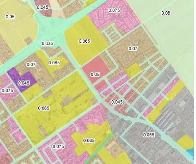
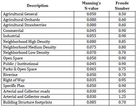
16 Floodplain Roughness
17 Hydrology Options Off site return period flood inflows Rainfall frequency events NEXRAD replicate storms Integrate with Santa Clara River flows Infiltration Groundwater Spatially and temporally variable rainfall

18 Channel System

19 Storm Drain System

20 Storm Drain Model - Details Channel flows enter a closed conduit for about 5000 ft through the urban environment. The storm drain system redistribute flood volumes through the urban environment
21 Storm Drain Network 9 independent storm drain lines with 250 conduits, 174 inlets, 9 outfalls Pipes ranged from 1ft to 9ft in diameter Pipe lengths ranges from 20 to 800 ft with a total of 6.6 miles of pipes The pipe capacity ranged from 2 cfs to 3,500 cfs

22 Hydraulic Structures - 90

23 Flood Damage $$ for Depths > 0.5 ft


24 10yr Flood Animation Risk Analysis

25 Without Storm Drain 10-year flood
26 With Storm drain 10-year flood Impact
27 Questions?
STAFFORD TRACT NORTH OF US90A 1.0 INTRODUCTION 1.1 OBJECTIVE
 1.0 INTRODUCTION 1.1 OBJECTIVE This report, prepared for submittal to TxDOT, analyzes existing and proposed detention facilities draining into the TxDOT US90A storm sewer system. The results of the detailed
BRISBANE BAYLANDS INFRASTRUCTURE PLAN FEBRUARY 2011 APPENDIX O DRAFT
 BRISBANE BAYLANDS INFRASTRUCTURE PLAN FEBRUARY 2011 APPENDIX O DRAFT PRELIMINARY STORM DRAIN CALCULATIONS ASSOCIATED WITH BRISBANE BAYLANDS REDEVELOPMENT BRISBANE, CALIFORNIA Prepared by BKF Engineers
Pollutant Removal Benefits
 Bioswales Bioswales Similar to biocells, but have a slight, but positive grade toward an outlet Designed to convey the WQv event at very low velocities Promote filtration through native vegetation, infiltration
ARIZONA WATER COMPANY
 ARIZONA WATER COMPANY East Sedona Water Storage Facility February 21, 2018 Community Meeting STORMWATER RUNOFF Issue: Runoff sometimes flows out of the wash at bottlenecks in front of several homes on
MEMORANDUM. September 10, 2018
 September 10, 2018 MEMORANDUM TO: Chad Bird, City of Decorah FROM: Larry Weber and Dan Gilles, Iowa Flood Center, IIHR Hydroscience & Engineering COPY TO: Dana Werner, St. Paul District Corps of Engineers,
Modeling Cumulative LID Features for Floodplain Impacts in an Urban Watershed in Houston, TX
 Modeling Cumulative LID Features for Floodplain Impacts in an Urban Watershed in Houston, TX Christina Hughes, Phil Bedient cmhughes@rice.edu May 2, 2014 1 Modeling Cumulative LID Features for Floodplain
NAPA COUNTY PUBLIC WORKS Standards & Specifications
 Roadway Design & Construction Manual (Table of Contents) 1. Chapter 1: General Provisions 1.1 Short Title 1.2 Jurisdiction 1.3 Purpose and Effect 1.4 Enactment Authority 1.5 Amendment and Revisions 1.6
MANUAL OF DESIGN, INSTALLATION, AND MAINTENANCE REQUIREMENTS FOR STORMWATER MANAGEMENT PLANS
 MANUAL OF DESIGN, INSTALLATION, AND MAINTENANCE REQUIREMENTS FOR STORMWATER MANAGEMENT PLANS May 2007 SECTION 1 Responsibility of Applicant TABLE OF CONTENTS A. Stormwater Management Plan Required Information
Bioretention cell schematic key
 Bioretention Cells Bioretention cell schematic key 1 3 Hardwood mulch 2 Curb cut 3 18-30 Modified soil 4 Stone aggregate choker layer 5 Stone aggregate base layer 6 Subdrain 7 Undisturbed soil 8 Overflow/Cleanout
City of Norfolk Coastal Flood Mitigation Program. March 13, 2013
 City of Norfolk Coastal Flood Mitigation Program March 13, 2013 Topics Brief overview of Norfolk s Coastal Flood Program Data-driven analysis and decision making City-wide vulnerability, project concepts,
Draft Rhode Island Stormwater Design and Installation Standards Manual
 Draft Rhode Island Stormwater Design and Installation Standards Manual Summary The May 2009 Public Review Draft version of the RI Stormwater Design and Installation Standards Manual consists of approximately
Figure 1 Cypress Street Study Area Location Map
 July 20, 2016 TO: FROM: Jim Massarelli Director of Engineering Jeff Julkowski, PE Michael Burke, PE SUBJECT: Cypress Street Study Area Stormwater Analysis (CBBEL Project No. 16-0058) At the request of
2I-5 Bioswales (Numbering pending)
") Iowa Stormwater Management Manual 2I-3 2I-5 Bioswales (Numbering pending) Source: Steve Anderson, 2011 BENEFITS Low =
Iowa Stormwater Management Manual 2I-3 2I-5 Bioswales (Numbering pending) Source: Steve Anderson, 2011 BENEFITS Low =
Development and Design of Cost-Effective, Real-Time Implementable Sediment and Contaminant Release Controls
 Development and Design of Cost-Effective, Real-Time Implementable Sediment and Contaminant Release Controls Richard Warner, Ph.D. Biosystems and Agricultural Engineering Department University of Kentucky
Stormwater Master Plan Update. City Council Briefing January 8, 2019
 Stormwater Master Plan Update City Council Briefing January 8, 2019 1 Stormwater Master Plan Update January 8, 2019 Agenda Background for Update Stormwater Modeling and Calibration Visualizations of Results
CHECKLIST FOR PHASE II DRAINAGE REPORT
 I. COVER SHEET CHECKLIST FOR PHASE II DRAINAGE REPORT A. Name of Project B. Address C. Owner D. Developer E. Engineer F. Submittal date and revision dates as applicable II. GENERAL LOCATION AND DESCRIPTION
Baltimore, MD Lt. Gov. Boyd Rutherford
 MODEL STANDARD PLAN FOR POULTRY HOUSE SITE DEVELOPMENT ON MARYLAND S EASTERN SHORE MARCH 2011 1800 Washington Boulevard 410-537-3000 Gov. Larry Hogan Baltimore, MD 21230-1718 800-633-6101 Lt. Gov. Boyd
Green Infrastructure Modeling in Cincinnati Ohio. Small Scale Green Infrastructure Design Using Computer Modeling
 Green Infrastructure Modeling in Cincinnati Ohio Small Scale Green Infrastructure Design Using Computer Modeling Presenters Jason Abbott is a Design Engineer with over 17 years of experience. Jason is
KYTC and NFIP: Bridging Floodplain Management and Design KAMM CONFERENCE AUGUST 25, 2015
 KYTC and NFIP: Bridging Floodplain Management and Design KAMM CONFERENCE AUGUST 25, 2015 KYTC STATEWIDE DRAINAGE DESIGN Provide Drainage Design Services on an as needed basis: Perform hydraulic analysis
Blake C. Kronkosky, PE, Ph.D.
 Blake C. Kronkosky, PE, Ph.D. Blake.Kronkosky@statetecheng.com, CELL (512) 663-1954 Education Ph.D., Civil Engineering, Texas Tech University, May 2018: An Engineer's Guide for Estimating 1-Day, 100-Year
A Process-based Method to Simulate Terraces in SWAT
 西北农林科技大学 Northwest A&F University A Process-based Method to Simulate Terraces in SWAT Hui Shao, Claire Baffaut, Jiang Gao, Keqin Wang and Hujun Shang July 17-19, 2013 Terrace Distribution in China Terraces
 PSLS Surveyors' Conference Workshop Information Form Workshop Number: (leave blank if unknown) Hours: Workshop Title: Workshop Description: Suggested Speaker(s), affiliation/contact information 1. 2. 3.
City of Troutdale South Troutdale Road Storm Drainage Plan
 City of Troutdale South Troutdale Road Storm Plan January 29 City of Troutdale SOUTH TROUTDALE ROAD STORM DRAINAGE PLAN January 29 Prepared for: City of Troutdale 342 SW 4th Street Troutdale, OR 976 Prepared
Wallkill River. Floodplain Bench Project Phase 1. OCSWCD Kevin Sumner. October 2016 Orange County. Wendell Buckman
 Wallkill River Floodplain Bench Project Phase 1 October 2016 Orange County OCSWCD Kevin Sumner Wendell Buckman Introduction Location Define the Problem History Location MIDDLETOWN NEWBURGH PROJECT Location
Post Construction BMPs
 Post Construction BMPs Why are Post Construction BMPs important? With increased development brings the increase of impervious cover Parking lots, rooftops, driveways Storm water runoff volume increases
Santa Cruz River Master Plan. Presented to the Arizona Floodplain Management Association Spring Conference June 8-10, 2011
 Santa Cruz River Master Plan Presented to the Arizona Floodplain Management Association Spring Conference June 8-10, 2011 Introduction Who is FICO? 2 Project Team Kimley-Horn and Associates, Inc. River
The use of low head weirs to. perennial streams with their floodplains:
 The use of low head weirs to reconnect severely entrenched perennial streams with their floodplains: An Anne Arundel County TMDL Watershed Implementation Plan Strategy presented by Hala Flores, P.E Mid
Alternatives Analysis Summary Memorandum
 F 16253 Swingley Ridge Rd, Suite 100, St. Louis, MO 63017 636-777-3000 P 314.432.5812 F Alternatives Analysis Summary Memorandum To: City of Creve Coeur, Missouri By: Mark Meyer, PE Date: 09-25-2013 Re:
Using AutoCAD Civil 3D and ESRI ArcGIS to meet LEED-ND (Neighborhood Development) Requirements NDIA O Brien & Gere. All Rights Reserved.
 Requirements NDIA O Brien & Gere. All Rights Reserved.") Using AutoCAD Civil 3D and ESRI ArcGIS to meet LEED-ND (Neighborhood Development) Requirements NDIA 12457 1 Using AutoCAD Civil 3D and ESRI ArcGIS to meet LEED-ND (Neighborhood Development) Requirements
Using AutoCAD Civil 3D and ESRI ArcGIS to meet LEED-ND (Neighborhood Development) Requirements NDIA 12457 1 Using AutoCAD Civil 3D and ESRI ArcGIS to meet LEED-ND (Neighborhood Development) Requirements
Problem Understanding
 Introduction...2-1 Previous Data and Mapping...2-2 Known Problem Areas...2-3 Resident Survey.2-3 Introduction The Village of Downers Grove stormwater system includes storm sewers, streams, wetlands, roadway
ENGINEERING & CONSTRUCTION MANAGEMENT
 DATE: PROJECT: DIVISION OF ENGINEERING & CONSTRUCTION MANAGEMENT PLAN REVIEW PERMITTING ENGINEERING CONSTRUCTION COUNTY PLAN FILE NUMBERS: DESIGN FIRM: PRELIMINARY SUBDIVISION PLAT CHECKLIST INSTRUCTIONS:
Modeling Rain Garden LID Impacts on Sewer Overflows
 7 Modeling Rain Garden LID Impacts on Sewer Overflows Uzair (Sam) M. Shamsi In September 2010, the U.S. Environmental Protection Agency (USEPA) released a new version (5.0.021) of Storm Water Management
7th Avenue Creek Master Plan Development Project. City of St. Charles, IL. IAFSM CONFERENCE March 14, 2018 MARKET
 7th Avenue Creek Master Plan Development Project MARKET City of St. Charles, IL IAFSM CONFERENCE March 14, 2018 7 TH AVENUE CREEK PROJECT AREA 2 2008 RAIN EVENT 3 RESIDENTIAL STRUCTURE FLOODING COMMERCIAL
Neighborhood-Scale Water Quality Improvements The Broadway Neighborhood Stormwater Greenway Project
 Neighborhood-Scale Water Quality Improvements The Broadway Neighborhood Stormwater Greenway Project Presenter: Stacy Luell, Geosyntec Consultants Co-Authors: R. Batchelder, W. Tam, M. Hanna, M. Sadeghi
Village of Forest Park. July 27, Sewer Separation Evaluation
 Village of Forest Park July 27, 2015 Sewer Separation Evaluation Presentation Overview Study Background Historic Nature of Forest Park Drainage Scale of Flooding Problem Forest Park Sewer System Background
APPENDIX B. Hydrologic and Hydraulic Analysis
 APPENDIX B Hydrologic and Hydraulic Analysis HYDROLOGIC AND HYDRAULIC ANALYSIS PETERSBURG ROAD IMPROVEMENTS DOT&PF Project No. 67879 Prepared for: State of Alaska Department of Transportation and Public
Washington County, Maryland Division of Public Works Policy Manual
 Washington County, Maryland Division of Public Works Policy Manual Subject: Downstream Drainage Easement Category: Land Development Engineering Number: 7-4.1 Date: June 1, 2009 (effective) PURPOSE: The
TENNESSEE GAS PIPELINE COMPANY, L.L.C.
 TENNESSEE GAS PIPELINE COMPANY, L.L.C. HYDROLOGIC AND HYDRAULIC CALCULATIONS FOR ACCESS ROADS ALONG THE CONNECTICUT PIPELINE EXPANSION PROJECT CONNECTICUT LOOP Submitted by: Tennessee Gas Pipeline Company,
Stormwater BMP and Stream Restoration in a City Park. Jeff Herr P.E., D.WRE Jill Stachura
 Stormwater BMP and Stream Restoration in a City Park Jeff Herr P.E., D.WRE Jill Stachura 770.673.3673 JHerr@BrwnCald.com Project Location Camp Creek in Metro Atlanta 7 sq. mile drainage area at project
City of Elmhurst. Comprehensive Flood Plan. City of Elmhurst. City Council Meeting September 15, 2014
 City of Elmhurst City of Elmhurst Comprehensive Flood Plan City Council Meeting September 15, 2014 City of Elmhurst Presentation Overview Study Background Study Methodology Analysis of Three Additional
Jill Stachura STORMWATER BMP AND STREAM RESTORATION IN A CITY PARK. October 2013 Southeast Stormwater Association Annual Conference, Charlotte, NC
 Jill Stachura STORMWATER BMP AND STREAM RESTORATION IN A CITY PARK October 2013 Southeast Stormwater Association Annual Conference, Charlotte, NC Project Location Gwinnett County, GA: Population: 825,000
Successful Green Infrastructure Planning: A Micro-Scale Modeling and Field Investigation Approach
 Successful Green Infrastructure Planning: A Micro-Scale Modeling and Field Investigation Approach Hazem Gheith and Vinnie Treatment, Water Division, ARCADIS-US Hunter Kelly, Department of Sewage and Drainage,
Reducing New York City s CSOs Using Green Infrastructure
 Reducing New York City s CSOs Using Green Infrastructure Think Blue Maine Conference November 21-22, 2013 Portland, ME Anne Kitchell, LEED AP, Horsley Witten Group John McLaughlin, NYCDEP Matthew Jones,
Appendix K. Stormwater Management Plan
 Regional Municipality of Halton - Steeles Avenue (Regional Road 8) Class EA - Industrial Drive to Regional Road 25/Martin Street Appendix K Stormwater Management Plan PR226401.001 Rev. 2 PR.DOT, 00/01
ANSWER KEY MGSFlood v WWHM2012 (released 5/15/2015)
") ANSWER KEY MGSFlood v. 4.35 --- WWHM2012 (released 5/15/2015) Name: Date: Module 6.0: Advanced Topics in LID Design: Hydrologic Modeling General instructions: You may model facility dimensions to the nearest
ANSWER KEY MGSFlood v. 4.35 --- WWHM2012 (released 5/15/2015) Name: Date: Module 6.0: Advanced Topics in LID Design: Hydrologic Modeling General instructions: You may model facility dimensions to the nearest
Three Rivers Park District Administration Center Rain Garden
 Three Rivers Park District Administration Center Rain Garden Introduction There are significant changes to the hydrologic regime and nutrient loading following urban and industrial development. The post-development
North Branch of Cypress Creek Ecological Restoration: A Comprehensive Approach to Stream Restoration
 North Branch of Cypress Creek Ecological Restoration: A Comprehensive Approach to Stream Restoration Rocky Powell Clear Creeks Consulting, LLC Keith D. Tate, P.E. BayLand Consultants & Designers, Inc.
Table of Contents G.1.a Water Resources - Surface Water - Drainage
 Table of Contents G.1.a Water Resources - Surface Water - Drainage 1. INTRODUCTION... 1335 2. ENVIRONMENTAL SETTING... 1335 a. Regional Hydrology... 1335 b. Local Hydrology... 1337 c. On-site Hydrology...
A. Regional Detention Requirements
 I. GENERAL DESIGN GUIDELINES A. Full-spectrum detention is provided for all new development, redevelopment or expansion of a site to provide for water quality and flood control detention. B. Detention
Lilburn, GA STORMWATER BMP AND STREAM RESTORATION IN A CITY PARK. July 2013 Jill Stachura
 Lilburn, GA STORMWATER BMP AND STREAM RESTORATION IN A CITY PARK July 2013 Jill Stachura Project Location Gwinnett County, GA: Population: 825,000 Area: 437 sq. miles 1,300 miles storm drainage system
Lincoln 270. City of Lincoln. Stormwater Management Plan. April 2, 2013
 Lincoln 270 City of Lincoln Stormwater Management Plan April 2, 2013 # 2005.48 Prepared By: Civil Engineering Solutions, Inc. 590 E Street Lincoln, Ca 95648 (916) 645 5700 1.0 Background: The project site
GIS-Enabled Rain Garden Design: A Case Study in Austin, Texas. GIS in Water Resources (C E 394K-3) Clint Smith, E.I.T.
 Clint Smith, E.I.T.") GIS-Enabled Rain Garden Design: A Case Study in Austin, Texas GIS in Water Resources (C E 394K-3), E.I.T., MSCE 12/07/2018 Table of Contents: 1. Abstract 3 2. Introduction 4 2.1 Background 4 2.2 Project
GIS-Enabled Rain Garden Design: A Case Study in Austin, Texas GIS in Water Resources (C E 394K-3), E.I.T., MSCE 12/07/2018 Table of Contents: 1. Abstract 3 2. Introduction 4 2.1 Background 4 2.2 Project
Updates to the Ground Infiltration Module in InfoWorks ICM 8.0
 Updates to the Ground Infiltration Module in InfoWorks ICM 8.0 Introduction The release of InfoWorks ICM version 8.0 has seen a couple of additional features added to the Ground Infiltration module to
Stormwater Retrofitting: The Art of Opportunity. Presented by the Center for Watershed Protection
 Stormwater Retrofitting: The Art of Opportunity Presented by the Center for Watershed Protection What Are Stormwater Retrofits? Retrofits are stormwater management measures inserted in an urban or ultra-urban
Checklists. Project Name: Location: File Number: Date of Submittal: Reviewer: Date: Applicant: Contact Name: Phone Number:
 Applicant: Contact Name: Phone Number: Email: Project Name: Location: File Number: Date of Submittal: Reviewer: Date: Concept Plan Requirements: I. General Project Information 1. Address or parcel number
PRELIMINARY DRAINAGE REPORT LATHAM 200 MMSCFD GAS PROCESSING PLANT
 PRELIMINARY DRAINAGE REPORT LATHAM 200 MMSCFD GAS PROCESSING PLANT LOTS B, RECORDED EXEMPTION 1211-2-1, RECX13-0096 LOCATED IN THE NORTH 1/2 OF SECTION 2, TOWNSHIP 3 NORTH, RANGE 66 WEST, 6 TH PRINCIPAL
Stormwater Pollution Prevention Plan Oneonta Heights Oneonta, NY TABLE OF CONTENTS PAGE
 Oneonta Heights Oneonta, NY TABLE OF CONTENTS PAGE I. INTRODUCTION... 2 II. EXISTING CONDITIONS... 3 A. Topography/ Drainage... 3 B. Soils... 3 C. Wetlands... 3 D. Floodplain... 3 E. NYSDEC Environmental
Chapter 4 - Preparation of Stormwater Site Plans
 Chapter 4 - Preparation of Stormwater Site Plans The Stormwater Site Plan is the comprehensive report containing all of the technical information and analysis necessary for the City to evaluate a proposed
Brigitte A. Berger, Director of Engineering
 Brigitte A. Berger, Director of Engineering Wilmette s Sewer System Overview of Wilmette s Sewer System Green vs. Gray? Stormwater Action Plan Regulatory Compliance Why Homes Flood What can
Village of New Maryland. Storm Water Management Master Plan
 Village of New Maryland Storm Water Management Master Plan Village of New Maryland Storm Water Management Master Plan Fredericton Office 80 Bishop Drive Fredericton NB E3C 1B2 Canada Telephone: +1 506
Going Green with the NYS Stormwater Design Standards
 Going Green with the NYS Stormwater Design Standards Shohreh Karimipour, P.E. NYSDEC History of Stormwater Management Ancient Greek Cisterns Water Cistern Systems in Greece from Minoan to Hellenistic Period,
DRAINAGE CALCULATIONS
 DRAINAGE CALCULATIONS For the Carroll Single Family Residence At Santa Clara County Saratoga, California APN: 517-26-010 December 18, 2015 Prepared For: John and Peggy Carroll Prepared By: RI Engineering,
Green Infrastructure Implementation Planning for Multiple Objectives
 Green Infrastructure Implementation Planning for Multiple Objectives Hazem Gheith, ARCADIS September 10, 2014 Imagine the result Integrated Plan for Stormwater Control Integrated Plan Objective Sanitary
Somerville Station Area and Landfill Redevelopment. Green Seam & Wetland Conceptual Restoration Design Plan
 Somerville Station Area and Landfill Redevelopment Green Seam & Wetland Conceptual Restoration Design Plan 1 Project Overview Located adjacent to the Somerville, NJ Transit station, a former municipal
NYC DEP s Approach to Flood Mitigation: The Local Flood Analysis (LFA) Process
 Process") NYC DEP s Approach to Flood Mitigation: The Local Flood Analysis (LFA) Process Milone & MacBroom, Inc. Jenabay Sezen, EIT Connecticut Association of Floodplain Managers October 25, 2016 Agenda Introduction
NYC DEP s Approach to Flood Mitigation: The Local Flood Analysis (LFA) Process Milone & MacBroom, Inc. Jenabay Sezen, EIT Connecticut Association of Floodplain Managers October 25, 2016 Agenda Introduction
6.1 Bioretention Areas
 SAN MATEO COUNTYWIDE WATER POLLUTION PREVENTION PROGRAM 6.1 Bioretention Areas Figure 6-1. Bioretention Area. Source: City of Brisbane Bioretention areas 1, or rain gardens, are concave landscaped areas
Article 20 Stormwater Management
 Article 20 Section 20.01 Intent Article 20 The purpose of this Article is to protect the health, safety, and general welfare of the citizens by requiring compliance with accepted standards and practices
Severn River Sub-Watershed: BMP 09-Retrofit
 Project ID: BMP_09 Total Treated Drainage Area: 4.57 acres Total Treated Impervious Area: 2.9 acres Total Water Quality Volume (WQv): ~10,300 cubic feet; 0.236 acre-foot Rainfall Depth Treated (Pe): 1
Rainwater Management an issue for the 21 st Century. Hydrological Cycle
 Canadian Society of Landscape Architects CONGRESS 2014 Rainwater Management an issue for the 21 st Century Don Crockett, BCSLA, CSLA Principal, Golder Associates Ltd. May 2014 Hydrological Cycle PRE- URBAN
 Stormwater Management Plan Narrative Quality Fleet Services, Inc. SITE RE-DEVELOPMENT 548 New Ludlow Road South Hadley, MA The project proposed by Quality Fleet Services, Inc. consists of the site improvements
When planning stormwater management facilities, the following principles shall be applied where possible.
 2.0 Principles When planning stormwater management facilities, the following principles shall be applied where possible. 2.0.1 Drainage is a regional phenomenon that does not respect the boundaries between
STORM DRAINAGE CONSTRUCTION NOTES LENGTH RUN * See Note 2., Above or greater 500
 STORM DRAINAGE CONSTRUCTION NOTES 1. ALL STORM SEWER PIPE SHALL BE REINFORCED CONCRETE UNLESS APPROVED BY THE CITY ENGINEER. 2. STORM DRAINAGE PIPES SHALL BE A MINIMUM OF FIFTEEN (15) INCH DIAMETER (15"
South Campus Stormwater Master Plan. University of Illinois. June Clark Dietz, Inc S. Neil Street, Suite 100 Champaign, Illinois 61820
 South Campus Stormwater Master Plan University of Illinois June 2007 Submitted by Clark Dietz, Inc. 1817 S. Neil Street, Suite 100 Champaign, Illinois 61820 Table of Contents Executive Summary Section
Case 1:85-cv RGS Document 1769 Filed 06/15/12 Page 1 of 13. UNITED STATES DISTRICT COURT for the DISTRICT OF MASSACHUSETTS
 Case 1:85-cv-00489-RGS Document 1769 Filed 06/15/12 Page 1 of 13 UNITED STATES DISTRICT COURT for the DISTRICT OF MASSACHUSETTS UNITED STATES OF AMERICA, Plaintiff, CIVIL ACTION v. No. 85-0489-RGS METROPOLITAN
Runoff Modelling for Simulating Inundation in Urban Area as a Result of Spatial Development Change
 2012, TextRoad Publication ISSN: 2090-4215 Journal of Applied Environmental and Biological Sciences www.textroad.com Runoff Modelling for Simulating Inundation in Urban Area as a Result of Spatial Development
Regenerative Stormwater Conveyances: Giving Old, Perched Outfalls New Life APWA NC Stormwater Management Division Conference
 Regenerative Stormwater Conveyances: Giving Old, Perched Outfalls New Life APWA NC Stormwater Management Division Conference 16 September 2014 Ward Marotti Senior Scientist Project Manager David Kiker
SECTION 5: REACH RECOMMENDATIONS/MAPS
 SECTION 5: REACH RECOMMENDATIONS/MAPS This section describes areas of concern and provides specific recommendations for each project reach. Locations of stormwater drains were from GIS coverage supplied
Brian Friedlich, PE. Jeremiah Bergstrom, LLA
 Engineering Concepts for Bioretention Facilities: From Rain Gardens to Basins NJASLA 2011 Annual Meeting & Expo February 1, 2011 Brian Friedlich, PE Senior Engineer Jeremiah Bergstrom, LLA Senior Project
Huntington Stormwater Utility
 Huntington Stormwater Utility Stormwater Management & Sediment and Erosion Control Requirements for Construction Sites Authorized by Huntington City Code Articles: 971, 970, 930, 935, 955, Revised April
Chapter 1 GENERAL SOUTH DAKOTA DRAINAGE MANUAL
 Chapter 1 GENERAL SOUTH DAKOTA DRAINAGE MANUAL October 2011 Table of Contents Section Page 1.1 INTRODUCTION...1-1 1.2 BASIC APPROACH...1-2 1.3 FUNCTIONAL RESPONSIBILITIES...1-3 1.3.1 Office of Road Design...1-3
2E-4 Bioretention Cells
 Iowa Stormwater Management Manual 2E-4 2E-4 Bioretention Cells BENEFITS Low =
FLAGSTAFF FAMILY FOOD BANK Erik Henricksen, Elena Smith, Garrett Ribas, and Meshal Alotaibi Client: Joshua Spears TA: Dr.
 FOOD STORAGE FACILITY FLOODING FLAGSTAFF FAMILY FOOD BANK Erik Henricksen, Elena Smith, Garrett Ribas, and Meshal Alotaibi Client: Joshua Spears TA: Dr. Wilbert Odem 1 BACKGROUND Figure 1: Food Bank Front
M-231 and Water Quality. Ottawa County Water Quality Forum November 21, 2016 James Fortney, MDOT
 M-231 and Water Quality Ottawa County Water Quality Forum November 21, 2016 James Fortney, MDOT M-231 Facts: 7-Miles long 2-Lane Limited Access Highway Connects I-96 and M-45 M-231 Facts: Includes Michigan
South Bismarck Watershed Model Update and Stormwater Improvement Project
 Preliminary Engineering Report Bismarck Tribune South Bismarck Watershed Model Update and Stormwater Improvement Project City of Bismarck, ND January 2017 14.105.0046 1.0 Executive Summary The focus of
EMERGENCY ACTION PLAN
 EMERGENCY ACTION PLAN Lake Sunapee Dam Sunapee, NH Dam #229.04 (Class B Dam) Water Division Lake Sunapee Dam - Sunapee, NH TABLE OF CONTENTS Section 1 Section 2 Section 3 Section 4 Notification Flowchart
Don t Flood The Rodeo! Preparing for Fort Worth s New Arena
 Don t Flood The Rodeo! Preparing for Fort Worth s New Arena T F M A S P R I N G C O N F E R E N C E APRI L 27 2017 Scott Hubley, P.E., CFM Justin Oswald, P.E., CFM Christopher Johnson, P.E., CFM PHOTO
STREAM BANK STABILIZATION THORPS MORTIMER RECREATION AREA Grandfather Ranger District SITE LOCATION & DRAINAGE AREA
 STREAM BANK STABILIZATION THORPS CREEK @ MORTIMER RECREATION AREA SITE LOCATION & DRAINAGE AREA SITE LOCATION Drainage Area = 1.14 sq. miles STREAM BANK STABILIZATION THORPS CREEK @ MORTIMER RECREATION
Development of LID Design Guide in Edmonton
 Development of LID Design Guide in Edmonton Xiangfei Li and Fayi Zhou, the City of Edmonton Dan Healy, AMEC Earth and Environmental Philadelphia LID Symposium September 26, 2011 Outline Why LID Why develop
Managing Stormwater within the Road Right-of-Way: An Urban NAI Approach
 Turgay Dabak, Joni Calmbacher, Sara DeGroot, Andrea Ryon Managing Stormwater within the Road Right-of-Way: An Urban NAI Approach Presentation Outline Project Background Project Overview BMPs Evaluated
Outfall Retrofit Feasibility Study
 Outfall Retrofit Feasibility Study 2013 APWA-NC SWM Conference September 16-17, 2013 Overview PWD history with outfall retrofits Project setting Review of screening factors and weighting scale QA/QC process
VA DCR STORMWATER DESIGN SPECIFICATION NO. 11 WET SWALE. VERSION 2.0 January 1, 2013 SECTION 1: DESCRIPTION
 VIRGINIA DCR STORMWATER DESIGN SPECIFICATION No. 11 VERSION 2.0 January 1, 2013 SECTION 1: DESCRIPTION Wet swales can provide runoff filtering and treatment within a conveyance system and are a cross between
C.1 Operational Information Requirements
 C.1 Operational Information Requirements 1.1 The Existing Galway Waste Water Works The Galway City sewer network has expanded with the development of the city, and the oldest sewers can be found in city
General Technical Guidance for Treatment Measures
 Chapter 5 General Technical Guidance for Treatment Measures This Chapter contains guidance on: Hydraulic sizing criteria, Applicability of non-landscape based treatment measures, Using Manufactured Treatment
CHAPTER 9 STORM DRAINAGE. Minimum Requirements for New Development and Redevelopment
 CHAPTER 9 STORM DRAINAGE 9.01 General The standards established by this chapter are intended to represent the minimum standards for the design and construction of storm drainage facilities. 9.02 Design
Tracking spatiotemporal patterns of building vulnerabilities and evacuations during flood hazards
 Tracking spatiotemporal patterns of building vulnerabilities and evacuations during flood hazards Shane Hubbard Junchuan Fan Kathleen Stewart Emily White The University of Wisconsin Madison, SSEC/CIMSS
Using the Past to Understand the Present Emerging Lessons for Environmental Planning in the Santa Clara Valley
 Using the Past to Understand the Present -- -- -- Emerging Lessons for Environmental Planning in the Santa Clara Valley Robin Grossinger Director of the Historical Ecology Program San Francisco Estuary
5. LOW IMPACT DEVELOPMENT DESIGN STANDARDS
 5. LOW IMPACT DEVELOPMENT DESIGN STANDARDS Low Impact Development (LID) requires a shift in stormwater management away from conveying runoff to a small number of downstream points through hydraulically
3/7/2013. Compliance & Sustainability
 Overview www.kieser associates.com Celebrating 20 Years of Excellence in Environmental Science & Engineering WMU Arcadia Creek Stormwater Treatment and Floodplain Enhancement Project DEQ #2008 0018 and
Planning the BMP. Region 2000 Planning District Commission Lynchburg, VA December 13, 20013
 Planning the BMP Region 2000 Planning District Commission Lynchburg, VA December 13, 20013 PLANNING THE BMP AGENDA BMP Selection BMP Design SWM Plan Preparation 2 BMP SELECTION Types of BMPs Structural
Old Mill Community Association Bioretention Facility
 Project Overview This project will install a bioretention facility in a community recreation area owned by the Old Mill Community Association, Inc. Drainage from the area is currently unmanaged and has