BLACK/HARMONY/FAREWELL CREEK WATERSHED EXISTING CONDITIONS REPORT CHAPTER 5 IMPERVIOUS SURFACES
|
|
|
- Garry Gervase Cooper
- 5 years ago
- Views:
Transcription


1 BLACK/HARMONY/FAREWELL CREEK WATERSHED EXISTING CONDITIONS REPORT CHAPTER 5 IMPERVIOUS SURFACES Draft November 2009
2 TABLE OF CONTENTS 1.0 INTRODUCTION STUDY AREA AND SCOPE METHODOLOGY FINDINGS Black/Harmony/Farewell Creek Watershed Subwatershed Findings Harmony Creek Subwatershed Ritson Subwatershed Wilson Subwatershed Grandview Subwatershed Taunton Subwatershed Mitchell Subwatershed Farewell Creek Subwatershed Black Creek Subwatershed CONCLUSIONS REFERENCES LIST OF TABLES Table 1: Imperviousness and ELC/land use classifications Table 2: Maximum impervious values as a percent Table 3: Total subwatershed imperviousness LIST OF FIGURES Figure 1: Black/Harmony/Farewell Creek watershed Figure 2: Black/Harmony/Farewell Creek watershed impervious areas Figure 3: Ritson subwatershed impervious areas Figure 4: Wilson subwatershed impervious areas Figure 5: Grandview subwatershed impervious areas Figure 6: Taunton subwatershed impervious areas Figure 7: Mitchell subwatershed impervious areas Figure 8: Farewell Creek subwatershed impervious areas Figure 9: Black Creek subwatershed impervious areas Page 2 of 26


 requires, except with respect to land in Settlement Areas, that all development and site alteration are prohibited")
3 1.0 INTRODUCTION Impervious surfaces are impenetrable surfaces that prevent rainwater from infiltrating into the soil. Impervious surfaces affect a watershed in many ways: reduce the rate of groundwater recharge; increase the volume and rate of stormwater runoff; increase the temperature of stormwater runoff; and increase the concentration of pollutants carried to the receiving watercourse Cumulatively, these changes may adversely impact the aquatic and other biological communities. Examples of impervious surfaces include sidewalks, paved driveways, roadways or parking lots, and rooftops. Imperviousness may be considered a direct result of land development, as such it can be used as a general indicator of potential water quantity and quality impacts to the watershed and subwatershed. Targets for the percent imperviousness for watersheds may be set to assist in managing land development to mitigate impacts on streams locally and cumulatively at a watershed scale. Therefore, it is important to investigate and report on the location and the percentages of impervious surfaces within the Black/Harmony/Farewell Creek watershed and subwatersheds. Applicable Legislation and Policies The Oak Ridges Moraine Conservation Plan (ORMCP) requires, except with respect to land in Settlement Areas, that all development and site alteration are prohibited if they cause the total percentage of the area of the subwatershed that has impervious surfaces to exceed 10% or any lower percentage prescribed in the applicable watershed plan (Ministry of Municipal Affairs and Housing (MMAH), 2002). Approval authorities are to consider, with respect to land development or site alteration applications in settlement areas, keeping impervious surfaces and their impacts on water quality and quantity to a minimum (Ministry of the Environment (MOE), 2007). imperviousness may be considered a direct result of land development, as such it can be used as a general indicator of potential water quantity and quality impacts to the watershed and subwatershed Page 3 of 26


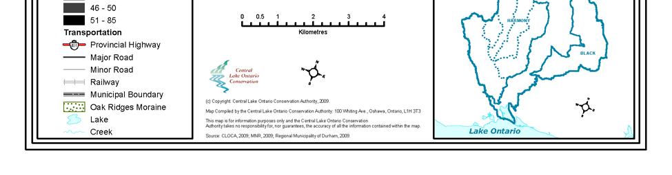
4 2.0 STUDY AREA AND SCOPE The Black/Harmony/Farewell Creek watershed is situated entirely within the Regional Municipality of Durham and covers an area of approximately 108 km 2 (Figure_1). The watershed drains southerly towards Lake Ontario from its headwaters which originate in the south slope till plain of the Oak Ridges Moraine. The Black/Harmony/Farewell Creek watershed is divided into 3 primary subwatersheds: Black Creek, Harmony Creek and Farewell Creek. The Harmony Creek subwatershed is further divided into 5 subwatersheds: Ritson, Wilson, Grandview, Taunton and Mitchell. This chapter focuses on the impervious surfaces found within the watershed and each subwatershed. Identification of imperviousness is based primarily on land use and natural land cover information derived from an interpretation of CLOCA s 2005 orthophotography coverage of the watershed. The information presented in this chapter represents estimates of the existing conditions as of 2005, at a subwatershed-wide rather than at a local scale. For instance, a high density urban residential area may be assumed to have about 85% of its area impervious to water infiltration from a subwatershed perspective, while locally within the residential area the actually imperviousness may be highly variable. Scale is an important consideration when reviewing the possible impacts of hardening surfaces to water penetration. identification of imperviousness is based primarily on land use and natural land cover information derived from an interpretation of CLOCA s 2005 orthophotography coverage of the watershed Black Creek subwatershed Page 4 of 26
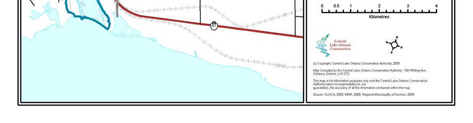
5 Figure 1: Black/Harmony/Farewell Creek watershed. Page 5 of 26

6 3.0 METHODOLOGY Calculating the level of imperviousness within the watershed was carried out using three main steps: reclassification of the Ecological Land Classifications (ELC) categories, the reader is referred to Chapter 17 Terrestrial Natural Heritage Appendix A for detailed ELC information; a literature review of land use designation and the associated impervious values; and a spatial analysis of imperviousness within the Lynde Creek. The Oak Ridges Moraine Conservation Plan (ORMCP) technical guidance document #13 (MOE, 2007) suggests three GIS based methods for calculating the impervious areas within a watershed including random sampling, digitizing or land classification. The method that CLOCA has chosen to use is a variation of digitizing. It is felt that the method is reliable and uses data that is already complete and available. The methodology used to determine the impervious areas is described below. Impervious surfaces are directly related to land use and thus to obtain values describing this characteristic, the land cover for the area must be known. CLOCA has developed an extensive inventory of the Ecological Land Classification and land use for the watershed. The ELC/land use data was derived from 2008 colour orthophotos and the ELC categories are as defined in the Ecological Land Classification for Southern Ontario (Lee et al. 1998). It is this data set that is used to determine the impervious area for the subject area. impervious surfaces are directly related to land use and thus to obtain values describing this characteristic, the land cover for the area must be known A literature review of land use designations and typical impervious values was conducted. Sources such as the Ministry of Transportation Drainage Manual (MTC, 1982) and Visual Otthymo Manual (Greenland, 2002) provide a range of average parameters that are typically used in hydrology applications. In order to apply the typical values a reclassification of the ELC/land use values is necessary. The values from the ELC and land use were assigned a more general classification, referred to as the dissolved land use. The ELC/land use categories that were assigned to the dissolved land use categories are shown in Table_1. Page 6 of 26
7 Table 1: Imperviousness and ELC/land use classifications. Dissolved Land Use Crop & Improved CLOCA Land Use Agricultural Facility Crop Field Nursery GIS Classification Pasture & Unimproved Pasture Cultural Meadow Transportation Greenspace Cultural Savannah Urban Residential Rural Residential High Density Urban Residential Industrial & Commercial Treed Field (Orchard) Urban Residential Rural Residential Apartment Buildings Commercial Industrial Institutional Building ELC Cultural Thicket Lakes and Wetlands Stormwater Pond Open Fen Water Feature Meadow Marsh Shallow Marsh Open Aquatic Submerged shallow aquatic Floating-leaved shallow aquatic Deciduous Swamp Coniferous Swamp Mixed Swamp Woodlot & Forest Manicured Green space Landfill and Aggregate Transportation & Utility Athletic field Golf facility Institutional green space Park Ski hill Aggregate Landfill Transportation Corridor Utility Corridor Utility Transfer Station Thicket Swamp Cultural Plantation Cultural Woodland Coniferous Forest Deciduous Forest Mixed Forest ELC/land use categories were assigned to the dissolved land use categories Page 7 of 26
 Crop & Improved 0 Pasture & Unimproved 0 Urban Residential 45 Rural Residential 20 High Density Urban Residential 85 Industrial & Commercial 85 Lakes and Wetlands 0 Woodlot &")
8 Table_2 details the compiled values for imperviousness for each land use classification used by CLOCA. Table 2: Maximum impervious values as a percent. Land Use Maximum (%) Crop & Improved 0 Pasture & Unimproved 0 Urban Residential 45 Rural Residential 20 High Density Urban Residential 85 Industrial & Commercial 85 Lakes and Wetlands 0 Woodlot & Forest 0 Manicured Green space 0 Landfill and Aggregate 50 Transportation & Utility 50 Inherent in any methodology it is understood that a margin of error exists. While every effort has been made to accurately present the findings reported in this chapter, factors such as significant digits and rounding, and processes such as computer digitizing and data interpretation may influence results. For instance, in data tables no relationship between significant digits and level of accuracy is implied and values may not always sum to the expected total due to rounding. values were compiled for imperviousness for each land use classification Harmony Creek subwatershed Page 8 of 26


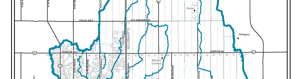
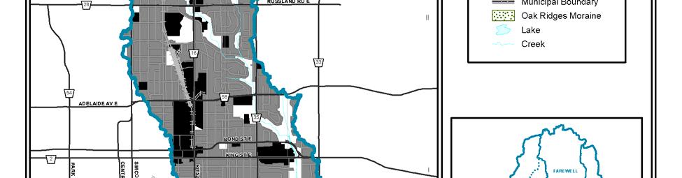
9 4.0 FINDINGS 4.1 Black/Harmony/Farewell Creek Watershed The percent imperviousness values for the specified land use have been paired with a land use map to illustrate the imperviousness for the Black/Harmony/Farewell Creek watershed. The overall imperviousness for the watershed is approximately 15%. The spatial distribution of impervious area is shown in Figure_2 where shading represents the estimated percent imperviousness. Urban areas predominate within the Oshawa portion of the watershed and within Clarington beginning slightly north of Nash Rd. to the southern watershed boundary. The sum of paved roadway surfaces represents the majority of the remaining watershed impervious areas. the overall imperviousness for the watershed is approximately 15% Page 9 of 26
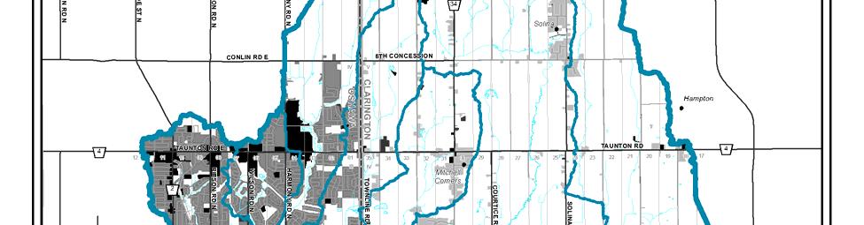
10 Figure 2: Black/Harmony/Farewell Creek watershed impervious areas. Page 10 of 26
 Harmony - Ritson 43.8 Harmony - Wilson 42.8 Harmony - Grandview 15.8 Harmony - Taunton 13.2 Harmony - Mitchell 16.")
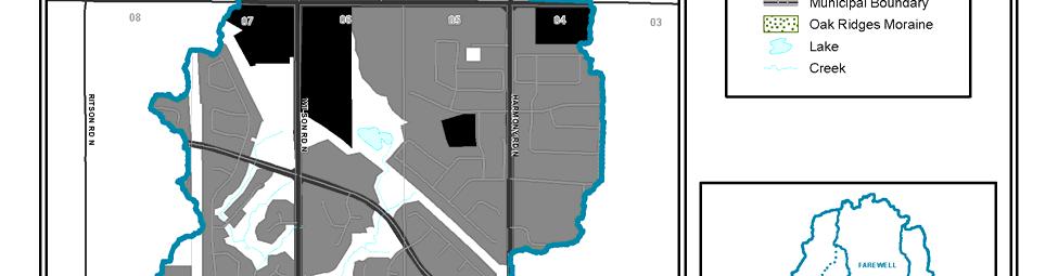
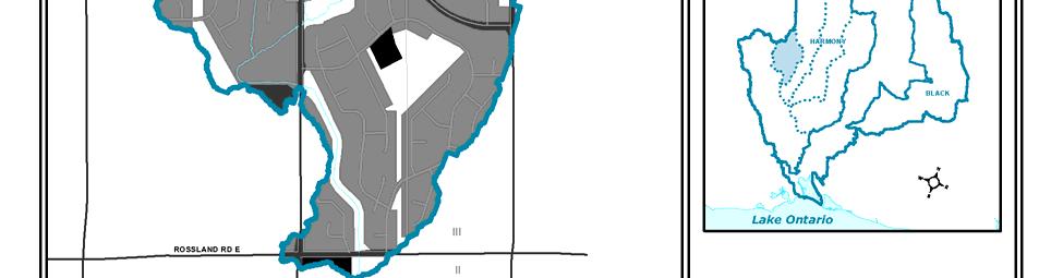
11 In addition to the mapping in Figure_2, Table_3 was prepared that summarizes the imperviousness of each subwatershed within the Black/Harmony/Farewell Creek watershed. Table 3: Total subwatershed imperviousness. Subwatershed Imperviousness (%) Harmony - Ritson 43.8 Harmony - Wilson 42.8 Harmony - Grandview 15.8 Harmony - Taunton 13.2 Harmony - Mitchell 16.2 Farewell 9.2 Black 5.3 A review of Figure_2 and Table_3 indicates that the Harmony Ritson and Wilson subwatershed are the most impervious of the Black/Harmony/Farewell Creek subwatersheds. These conditions are examined on a subwatershed scale in the following sections. 4.2 Subwatershed Findings Harmony Creek Subwatershed Ritson Subwatershed This subwatershed has the greatest percentage of imperviousness area within the Black/Harmony/Farewell Creek watershed at 43.8%. The majority of the impervious area within the subwatershed is due to roads and urban commercial and residential areas. This subwatershed is located entirely within the City of Oshawa s urban core, which is depicted in Figure_3. The Ritson subwatershed does not contain area classified as Oak Ridges Moraine. the Ritson subwatershed has the greatest percentage of imperviousness area at 43.8% Ritson Subwatershed Page 11 of 26

12 Figure 3: Ritson subwatershed impervious areas. Page 12 of 26


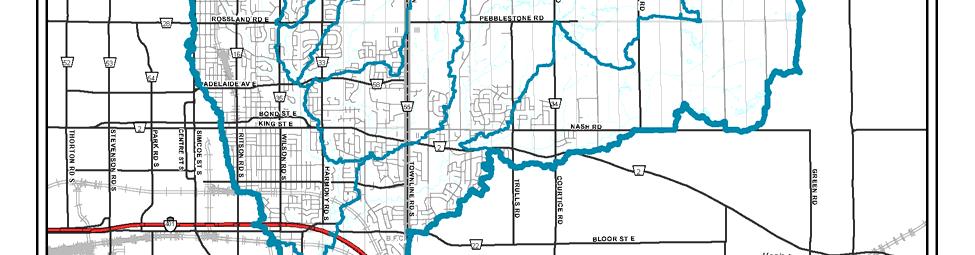
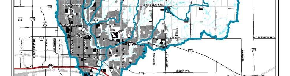
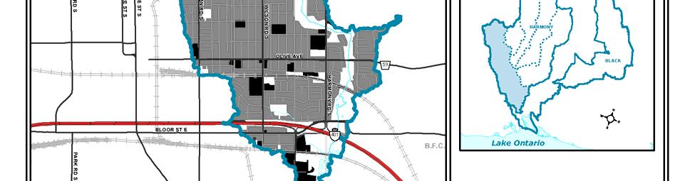
13 Wilson Subwatershed The Wilson subwatershed is also highly impervious, with a value of 42.8%. The majority of the impervious area within the subwatershed is due to roads and urban commercial and residential land use as this subwatershed is also included within the urban core of the City of Oshawa as shown in Figure_4. the Wilson subwatershed has an estimated total imperviousness of 42.8% Wilson Subwatershed Page 13 of 26

14 Figure 4: Wilson subwatershed impervious areas. Page 14 of 26

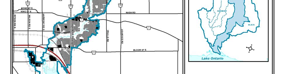
15 Grandview Subwatershed The Grandview subwatershed contains a very small portion of Oak Ridges Moraine land, approximately 15.6% of the subwatershed area. This subwatershed has a total imperviousness of approximately 15.8%. The majority of the impervious area within the Grandview subwatershed is due to paved roadways and urban commercial and residential areas including the area commonly referred to as the Taunton Community, which is depicted in Figure_5. There is a large commercial area centered on the Harmony Rd. and Taunton Rd intersection that accounts for a good percentage of the imperviousness within this subwatershed. Any development within the ORM, excluding lands within Settlement Areas, must ensure that the ORMCP requirements with respect to impervious surfaces are satisfied. Section 27 of the ORMCP states that impervious surfaces cannot exceed 10% within the subwatershed, or any lower percentage that is specified within the appropriate watershed plan. Settlement Areas and lands located outside of the Oak Ridges Moraine boundary are excluded. This subwatershed [Grandview] has a total imperviousness of approximately 15.8% Grandview Subwatershed Page 15 of 26


16 Figure 5: Grandview subwatershed impervious areas. Page 16 of 26


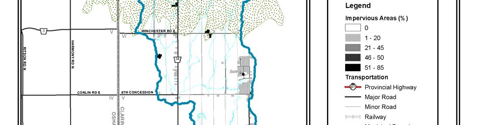
17 Taunton Subwatershed The Taunton subwatershed, of which also contains no Oak Ridges Moraine area, has a total imperviousness of 13.2%. The majority of the impervious area within the subwatershed is due to paved roads and urban residential land use, the majority of which being located within the Municipality of Oshawa as shown in Figure_6. the Taunton subwatershed has a total imperviousness of 13.2% Taunton Subwatershed Page 17 of 26


18 Figure 6: Taunton subwatershed impervious areas. Page 18 of 26


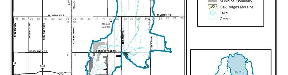
19 Mitchell Subwatershed The Mitchell subwatershed has a total imperviousness of 16.2%, and no Oak Ridges Moraine area. The majority of the impervious area within the subwatershed is due to roads and urban residential land use, as shown on Figure_7. The small settlement of Mitchell s Corners is located within this subwatershed and contributes a minor amount of impervious area. the Mitchell subwatershed has a total imperviousness of 16.2% Mitchell Subwatershed Page 19 of 26

20 Figure 7: Mitchell subwatershed impervious areas. Page 20 of 26


21 4.2.2 Farewell Creek Subwatershed The Farewell Creek subwatershed contains a small portion of Oak Ridges Moraine land, approximately 19.9% of the subwatershed area. This subwatershed has a total imperviousness of approximately 9.2%. The majority of the impervious area within the Farewell Creek subwatershed is due to paved roadways and urban residential, which is depicted in Figure_8. There are several small rural residential areas that have a minor contribution to the impervious value of the subwatershed. Any development within the ORM, excluding lands within Settlement Areas, must ensure that the ORMCP requirements with respect to impervious surfaces are satisfied. Section 27 of the ORMCP states that impervious surfaces cannot exceed 10% within the subwatershed, or any lower percentage that is specified within the appropriate watershed plan. Settlement Areas and lands located outside of the Oak Ridges Moraine boundary are excluded. the Farewell subwatershed has a total imperviousness of 9.2% Farewell Creek Subwatershed Page 21 of 26

22 Figure 8: Farewell Creek subwatershed impervious areas Page 22 of 26


23 4.2.3 Black Creek Subwatershed The Black Creek subwatershed contains a very small portion of Oak Ridges Moraine land, approximately 3.8% of the subwatershed area. This subwatershed has the least amount of impervious area, a total percentage of approximately 5.3%. The majority of the impervious area within the Black Creek subwatershed is due to paved roadways and several small urban residential and commercial land use areas, which are depicted in Figure_9. There are several small rural residential areas that have a minor contribution to the impervious value of the subwatershed. Any development within the ORM, excluding lands within Settlement Areas, must ensure that the ORMCP requirements with respect to impervious surfaces are satisfied. Section 27 of the ORMCP states that impervious surfaces cannot exceed 10% within the subwatershed, or any lower percentage that is specified within the appropriate watershed plan. Settlement Areas and lands located outside of the Oak Ridges Moraine boundary are excluded The Black Creek subwatershed has the least amount of impervious area, a total percentage of approximately 5.3% Black Creek Subwatershed Page 23 of 26


24 Figure 9: Black Creek subwatershed impervious areas Page 24 of 26

25 5.0 CONCLUSIONS Impervious surfaces interrupt the natural hydrologic cycle, by preventing the infiltration of rainwater into the ground, increasing the volume, rate and temperature of stormwater runoff, and increasing the concentration of pollutants carried to the receiving watercourse. In addition, cumulatively, these changes may adversely impact the aquatic and other biological communities. The Black/Harmony/Farewell Creek watershed has an imperviousness of approximately 15%, with the Ritson subwatershed having the highest imperviousness at 43.8%, due mainly to the urban core of the City of Oshawa. the Ritson subwatershed has the highest imperviousness at 43.8% WHAT WE DO ON THE LAND IS MIRRORED IN THE WATER Page 25 of 26
26 6.0 REFERENCES Greenland Consulting Ltd Visual Otthym0 v2.0 Reference Manual. April Lee, H.T., W.D. Bakowsky, J. Riley, J. Bowles, M. Puddister, P. Uhlig and S. McMurray Ecological Land Classification for southern Ontario: First Approximation and Its Application. Ontario Ministry of Natural Resources, Southcentral Science Section, Science Development and Transfer Branch. SCSS Field Guide FG-02. Ontario Ministry of the Environment Subwatersheds Impervious Surfaces. Technical Paper #13., Oak Ridges Moraine Conservation Plan. Final Version Ontario Ministry of the Environment. 2006a. SWP Draft Assessment Report: Guidance Module 2, Water Budgets. OMOE. April 10, Ontario Ministry of Transportation and Communications Drainage Manual Ministry of Municipal Affairs and Housing Oak Ridges Moraine Conservation Plan. Queens Printer for Ontario. Page 26 of 26
Township of Adjala-Tosorontio Official Plan Review. Natural Heritage
 Township of Adjala-Tosorontio Official Plan Review 13 Natural Heritage Introduction What is an Official Plan? An official plan is a municipal policy document which sets out the community s vision and strategies
TRCA Field Staking Protocol December 2016
 Page 1 of 6 TRCA Field Staking Protocol December 2016 This Protocol describes TRCA staff s current practice for field staking the physical top of bank, the physical toe of slope, and the limit of existing
3-2 Environmental Systems
 3-2 Environmental Systems 3.0 ENVIRONMENTAL SYSTEMS CONTENTS 3.1 GREENWAY SYSTEM 3.1.1 General Policies 3.1.2 Natural Heritage Network 3.1.3 Natural Heritage Network Enhancement Lands 3.1.4 Rouge Watershed
Community LID Workgroup Issue Paper #6
 Community LID Workgroup Issue Paper #6 Topic: Hard and Impervious Surface Coverage Limits Objective: Minimize the amount of hard and impervious surfaces in developments to allow more stormwater to infiltrate
TERRESTRIAL NATURAL HERITAGE SYSTEM STRATEGY APPENDIX F: MODEL POLICIES FOR THE IMPLEMENTATION OF THE TARGET TERRESTRIAL NATURAL HERITAGE SYSTEM
 TERRESTRIAL NATURAL HERITAGE SYSTEM STRATEGY APPENDIX F: MODEL POLICIES FOR THE IMPLEMENTATION OF THE TARGET TERRESTRIAL NATURAL HERITAGE SYSTEM C H A P T E R 1 M O D E L P O L I C I E S F O R I M P L
Central Lake Ontario Conservation Conservation Lands Master Plan
 Conservation Lands Master Plan Top 13 Frequently Asked Questions 1. What are conservation lands? Where are these conservation lands located in the Central Lake Ontario Conservation watershed? Conservation
Summary of Changes for the Comprehensive Draft Proposed Official Plan Amendment
 Summary of Changes for the Comprehensive Draft Proposed Official Plan Amendment Note: Due to the broad scope of the Official Plan Review, this list is not exhaustive of the extent of changes in the comprehensive
Peel Region. Greenbelt Plan Conformity. Plan Review. Background & Approach
 Peel Region Plan Review Background & Approach Greenbelt Plan Conformity November 2008 Page 2 of 13 2 COMMENT SHEET Region of Peel Greenbelt Plan Policy Review This comment sheet is to be used to provide
13. VANDORF-PRESTON LAKE SECONDARY PLAN 13.1 INTRODUCTION
 13. VANDORF-PRESTON LAKE SECONDARY PLAN 13.1.1 Purpose 13.1 INTRODUCTION The Vandorf-Preston Lake Secondary Plan establishes the principles, objectives and general policies, as well as specific strategies
Master Environmental Servicing Plan & Secondary Plan
 East Side Lands Stage 2 1 Master Environmental Servicing Plan & Secondary Plan Public Information Centre #1 June 16, 2016 Welcome! Today s Agenda Please sign in at the front desk. 5:30 pm 6:30 pm: Open
AMENDMENT NO. 30 TO THE OFFICIAL PLAN OF THE TOWN OF MILTON
 AMENDMENT NO. 30 TO THE OFFICIAL PLAN OF THE TOWN OF MILTON Subject: Boyne Survey Secondary Plan and Related Official Plan Amendments The following text and schedules constitute Amendment No. 30 to the
Draft Impervious Cover Reduction Action Plan for West Long Branch Borough, Monmouth County, New Jersey
 Draft Impervious Cover Reduction Action Plan for West Long Branch Borough, Monmouth County, New Jersey Prepared for West Long Branch Borough by the Rutgers Cooperative Extension Water Resources Program
Land Development Characteristics (Module 6)
") Land Development Characteristics (Module 6) Robert Pitt and Celina Bochis Department of Civil, Construction and Environmental Engineering The University of Alabama Tuscaloosa, AL 35487 Example of 1 m monochromatic
Land Development Characteristics (Module 6) Robert Pitt and Celina Bochis Department of Civil, Construction and Environmental Engineering The University of Alabama Tuscaloosa, AL 35487 Example of 1 m monochromatic
AMENDMENT NO. 2 TO THE TRENT HILLS OFFICIAL PLAN
 The Municipality of Trent Hills Official Plan AMENDMENT NO. 2 TO THE TRENT HILLS OFFICIAL PLAN Adopted by Council on Approved by the Ministry of Municipal Affairs and Housing on Version Date: November
11. BALLANTRAE-MUSSELMAN LAKE AND ENVIRONS SECONDARY PLAN
 11. BALLANTRAE-MUSSELMAN LAKE AND ENVIRONS SECONDARY PLAN 11.1 PURPOSE The Ballantrae-Musselman Lake and Environs Secondary Plan Area includes two small existing settlement areas, Ballantrae and Musselman
Draft Impervious Cover Reduction Action Plan for West New York, Hudson County, New Jersey
 Draft Impervious Cover Reduction Action Plan for West New York, Hudson County, New Jersey Prepared for the Town of West New York by the Rutgers Cooperative Extension Water Resources Program March 29, 2017
Chapter 3 Site Planning and Low Impact Development
 CHAPTER 3 Site Planning and Low Impact Development Chapter 3 Site Planning and Low Impact Development 3.0 Introduction The City of Charleston requires that major residential, large commercial (>1 acre),
APPENDIX A SIMPLIFIED APPROACH TO STORMWATER MANAGEMENT FOR SMALL PROJECTS. In West Sadsbury Township, Chester County, Pennsylvania
 APPENDIX A SIMPLIFIED APPROACH TO STORMWATER MANAGEMENT FOR SMALL PROJECTS In West Sadsbury Township, Chester County, Pennsylvania TABLE OF CONTENTS I. Introduction 3 II. Importance of Stormwater Management
Methods to Simulate the Impact of BMPs
 LA221 Project Ortega Watershed Demonstration Area, Quito Ecuador Ricardo da Cruz e Sousa Master of Landscape Architecture & Environmental Planning University of California, Berkeley December 2011 Ortega
City of Greater Sudbury Subwatershed Study Program. Public Open House Tom Davis Square, C-13 A and B March 9, 2016
 City of Greater Sudbury Subwatershed Study Program Public Open House Tom Davis Square, C-13 A and B March 9, 2016 Welcome to the City of Greater Sudbury Subwatershed Study Program Public Open House Tom
Impervious Cover Reduction Action Plan for City of Vineland, Cumberland County, New Jersey
 Impervious Cover Reduction Action Plan for City of Vineland, Cumberland County, New Jersey Prepared for the City of Vineland by the Rutgers Cooperative Extension Water Resources Program May 23, 2016 Table
THREE-STEP DESIGN PROCESS FOR OPEN SPACE SUBDIVISIONS
 00216106.DOC NMA/RRK 1/30/14 THREE-STEP DESIGN PROCESS FOR OPEN SPACE SUBDIVISIONS Open space subdivisions, sometimes called cluster developments, maintain a significant portion of a development site in
THE GREENBELT ACT AND PLAN
 Ontarians have come to value the Greenbelt since it was created in February 2005. It protects 1.8 million acres of environmentally sensitive and agricultural land around the Greater Golden Horseshoe. Growing
July 9, Adèle Labbé Environmental Planner City of Guelph 1 Carden Street Guelph, Ontario N1H 3A1. Dear Ms. Labbé.
 July 9, 2014 Adèle Labbé Environmental Planner City of Guelph 1 Carden Street Guelph, Ontario N1H 3A1 Dear Ms. Labbé. Re: 132 Clair Road West EIS Terms of Reference North-South Environmental Inc. (hereafter,
THE CORPORATION OF THE CITY OF WINDSOR Office of the City Solicitor Planning Department
 THE CORPORATION OF THE CITY OF WINDSOR Office of the City Solicitor Planning Department REPORT TO THE CITY OF WINDSOR PLANNING ADVISORY COMMITTEE DATE OF REPORT: August 19, 2010 SUBJECT: Official Plan
HAZARD MITIGATION GOALS AND OBJECTIVES
 SEWRPC Community Assistance Planning Report No. 282, 2nd Edition CITY OF MILWAUKEE ALL HAZARDS MITIGATION PLAN UPDATE Chapter IV HAZARD MITIGATION GOALS AND OBJECTIVES [NOTE: Throughout this plan update
APPENDIX I Presentations
 APPENDIX I Presentations Workshop Summary Report 11 Peel Region Official Plan Review May 5, 2010 Compatible Active Recreation Workshop July 29, 2010 Components of PROPR Sustainability Planning Tools/Updates
Impervious Cover Reduction Action Plan for Hampton Township, Sussex County, New Jersey
 Impervious Cover Reduction Action Plan for Hampton Township, Sussex County, New Jersey Prepared for Hampton Township by the Rutgers Cooperative Extension Water Resources Program November 8, 2016 Table
Draft. Impervious Cover Reduction Action Plan for Dunellen Borough, Middlesex County, New Jersey
 Draft Impervious Cover Reduction Action Plan for Dunellen Borough, Middlesex County, New Jersey Prepared for Dunellen Borough by the Rutgers Cooperative Extension Water Resources Program September 22,
Great Lakes Conservation Blueprint for Terrestrial Biodiversity on the Canadian Shield
 Great Lakes Conservation Blueprint for Terrestrial Biodiversity on the Canadian Shield Bonnie L. Henson 1, Kara E. Brodribb 2 and John L. Riley 3 1 Ontario Ministry of Natural Resources 2,3 The Nature
RECOMMENDED DIRECTIONS REPORT FOR THE TOWN OF RICHMOND HILL
 RECOMMENDED DIRECTIONS REPORT ENVIRONMENTAL POLICY REVIEW FOR THE TOWN OF RICHMOND HILL Prepared for: Town of Richmond Hill 225 East Beaver Creek Road Richmond Hill, ON, L4B 3P4 Prepared by: SENES Consultants
Final Impervious Cover Assessment for Upper Deerfield Township, Cumberland County, New Jersey
 Final Impervious Cover Assessment for Upper Deerfield Township, Cumberland County, New Jersey Prepared for Upper Deerfield Township by the Rutgers Cooperative Extension Water Resources Program September
Chapter 4 - Preparation of Stormwater Site Plans
 Chapter 4 - Preparation of Stormwater Site Plans The Stormwater Site Plan is the comprehensive report containing all of the technical information and analysis necessary for the City to evaluate a proposed
Minnesota Department of Natural Resource - Natural Resource Guidance Checklist Conserving Natural Resources through Density Bonuses
 Minnesota Department of Natural Resource - Natural Resource Guidance Checklist Conserving Natural Resources through Density Bonuses NRDB Why Use Density Bonuses & This Checklist Local units of government
Major Subdivision Sketch Plan Checklist
 This checklist provides specific requirements that are apart of the Sketch process. The entire process is described by the Huntersville Subdivision Review Process which details all the submittal and resubmittal
B R I E F A p p e n d i x A : F i g u r e s
 HALTON MUNICIPALITIES BRIEF: APPENDIX A 1 B R I E F A p p e n d i x A : F i g u r e s 2 0 1 6 Halton Municipalities Regional Municipality of Halton Corporation of the City of Burlington Corporation of
Draft Rhode Island Stormwater Design and Installation Standards Manual
 Draft Rhode Island Stormwater Design and Installation Standards Manual Summary The May 2009 Public Review Draft version of the RI Stormwater Design and Installation Standards Manual consists of approximately
7.0 SOCIAL, ECONOMIC, AND ENVIRONMENTAL ISSUES
 7.0 SOCIAL, ECONOMIC, AND ENVIRONMENTAL ISSUES The following list of social, economic, and environmental issues have been identified based on a preliminary inventory of resources in the project area, an
Chapter 1 - General Design Guidelines CHAPTER 1 GENERAL DESIGN GUIDELINES
 CHAPTER 1 GENERAL DESIGN GUIDELINES 1.0 INTRODUCTION This Publication has been developed to provide current, uniform procedures and guidelines for the application and design of safe, convenient, efficient
KING CITY COMMUNITY PLAN
 KING CITY COMMUNITY PLAN TOWNSHIP OF KING JANUARY 27, 2000 AMENDMENT NO. 54 to the OFFICIAL PLAN for the TOWNSHIP OF KING PLANNING AREA THE COMMUNITY PLAN TABLE OF CONTENTS PAGE PART 1 INTRODUCTION 1.1
APPENDIX 1: SCOPED ENVIRONMENTAL IMPACT STATEMENT (EIS) FORM
 FORM") APPENDIX 1: SCOPED ENVIRONMENTAL IMPACT STATEMENT (EIS) FORM This form is intended for use by applicants (primarily private landowners) who need to conduct a Scoped EIS in support of minor development
APPENDIX 1: SCOPED ENVIRONMENTAL IMPACT STATEMENT (EIS) FORM This form is intended for use by applicants (primarily private landowners) who need to conduct a Scoped EIS in support of minor development
STORMWATER MANAGEMENT CODES ANALYSIS RICHLAND COUNTY, SC SITE PLANNING ROUNDTABLE
 STORMWATER MANAGEMENT CODES ANALYSIS RICHLAND COUNTY, SC SITE PLANNING ROUNDTABLE Codes analyses for each subcommittee were completed to assist participants of the Richland County Site Planning Roundtable.
Draft Impervious Cover Reduction Action Plan for Newark, Essex County, New Jersey Volume 2
 Draft Impervious Cover Reduction Action Plan for Newark, Essex County, New Jersey Volume 2 Prepared for the City of Newark by the Rutgers Cooperative Extension Water Resources Program April 16, 2018 Table
CHAPTER 4 FUTURE LAND USE AND URBAN SERVICES DISTRICTS
 CHAPTER 4 FUTURE LAND USE AND URBAN SERVICES DISTRICTS Introduction This chapter discusses how Benzie County should grow and change in the future. A community can grow and change in many different ways.
SPECIAL COMMITTEE OF THE WHOLE DECEMBER 9, 2002 BLOCK 12 BLOCK PLAN FILE BL CASTAN BATHURST TESTON CORPORATION ET AL PRELIMINARY REPORT
 SPECIAL COMMITTEE OF THE WHOLE DECEMBER 9, 2002 BLOCK 12 BLOCK PLAN FILE BL.12.99 CASTAN BATHURST TESTON CORPORATION ET AL PRELIMINARY REPORT Recommendation The Commissioner of Planning recommends: THAT
Evaluating Low Impact Development Practices for Stormwater Management on an Industrial Site in Mississippi
 Evaluating Low Impact Development Practices for Stormwater Management on an Industrial Site in Mississippi Dennis S. Painter, Tennessee Valley Authority, Nashville, Tennessee Donald Becker, Tennessee Valley
Draft. Impervious Cover Reduction Action Plan for Fair Haven, Monmouth County, New Jersey
 Draft Impervious Cover Reduction Action Plan for Fair Haven, Monmouth County, New Jersey Prepared for Fair Haven by the Rutgers Cooperative Extension Water Resources Program June 10, 2016 Table of Contents
AMENDMENT NO. 107 TO THE CLARINGTON OFFICIAL PLAN ADOPTED BY CLARINGTON COUNCIL NOVEMBER 1, 2016
 AMENDMENT NO. 107 TO THE CLARINGTON OFFICIAL PLAN ADOPTED BY CLARINGTON COUNCIL NOVEMBER 1, 2016 Purpose The purpose and effect of the Recommended Official Plan Amendment No. 107 is to bring the Clarington
PAVING PARKING AREAS AND ROADS DESCRIPTION. Alternate Names: Pavement Practices, Impervious Paving
 4.2-i PAVING PARKING AREAS AND ROADS Alternate Names: Pavement Practices, Impervious Paving DESCRIPTION All roads, driveways, and parking lots proposed for year-round use shall be paved with a hard plowable
When planning stormwater management facilities, the following principles shall be applied where possible.
 2.0 Principles When planning stormwater management facilities, the following principles shall be applied where possible. 2.0.1 Drainage is a regional phenomenon that does not respect the boundaries between
Toronto Complete Streets Guidelines
 Toronto Complete Streets Guidelines 108 110 7.1 Green Infrastructure Design Principles 112 7.2 Context-Sensitive Green Streets 114 7.3 Key Green Street Elements Green infrastructure refers to natural and
Stormwater Retrofitting: The Art of Opportunity. Presented by the Center for Watershed Protection
 Stormwater Retrofitting: The Art of Opportunity Presented by the Center for Watershed Protection What Are Stormwater Retrofits? Retrofits are stormwater management measures inserted in an urban or ultra-urban
McKay Road Interchange and Salem / Lockhart Crossing
 McKay Road Interchange and Salem / Lockhart Crossing The McKay Road Interchange Class EA has two components: 1. A new MacKay Road Interchange at Highway 400; and 2. A new bridge crossing of Highway 400
Pennsylvania Stormwater Best Management Practices Manual. Chapter 1. Introduction and Purpose
 Pennsylvania Stormwater Best Management Practices Manual Chapter 1 Introduction and Purpose Chapter 1 Introduction and Purpose 1.1 Purpose of this Manual 1 1.2 How to Use this Manual...1 1.3 Overview
BISCUIT RUN PARK MASTER PLAN
 BOARD OF SUPERVISORS November 14, 2018 BISCUIT RUN PARK MASTER PLAN COUNTY OF ALBEMARLE ANHOLD ASSOCIATES Contents Project Introduction Property Background County Park Planning Process Existing Site &
SECTION UNIFIED DEVELOPMENT ORDINANCE SECTION Part 1 Ordinance. ARTICLE 1 Zoning Districts
 SECTION 1-100 UNIFIED DEVELOPMENT ORDINANCE SECTION 1-300 Part 1 Ordinance SECTION 1-100. Introduction. ARTICLE 1 Zoning Districts Crystal Lake strives to maintain a balance of various land uses for a
Keele Campus Storm Drainage. Presented by Mark Hagesteijn September 24, 2013
 Keele Campus Storm Drainage Presented by Mark Hagesteijn September 24, 2013 1 Presentation Overview Urbanization Impact on the Hydrologic Cycle Why Do We Manage Stormwater? Typical Stormwater Management
Directors Rules for Seattle Municipal Code, Chapters Stormwater Code
 Directors Rules for Seattle Municipal Code, Chapters 22.800 22.808 Stormwater Code Requirements for Green Stormwater Infrastructure to the Maximum Extent Feasible for Single-Family Residential and Parcel-Based
Appendix I. Checklists
 Appendix I Checklists Town of Greenwich Drainage Manual Department of Public Works - Engineering Division Town Hall - 101 Field Point Road, Greenwich, CT 06836-2540 Phone 203-622-7767 - Fax 203-622-7747
Environment and Sustainability. Environment and Sustainability
 4 Environment and Sustainability Environment and Sustainability ENVIRONMENT AND SUSTAINABILITY 4.1 CLIMATE CHANGE AND AIR QUALITY... 4-5 4.1.1 OBJECTIVES... 4-6 4.1.2 POLICIES... 4-6 4.2 NATURAL HERITAGE
Impervious Cover Assessment for Salem City, Salem County, New Jersey
 Impervious Cover Assessment for Salem City, Salem County, New Jersey Prepared for Salem City by the Rutgers Cooperative Extension Water Resources Program August 10, 2016 Introduction Pervious and impervious
Paul D. Ralph, BES, RPP, MCIP, Commissioner, Development Services Department. Proposed Storm Water Pond Maintenance Fee
 Public Report To: From: Report Number: Development Services Committee Paul D. Ralph, BES, RPP, MCIP, Commissioner, Development Services Department DS-16-211 Date of Report: December 1, 2016 Date of Meeting:
Pennsylvania Stormwater Best Management Practices Manual
 Pennsylvania Stormwater Best Management Practices Manual DRAFT - JANUARY 2005 Section 4 Comprehensive Stormwater Management: Integrating Site Design, Non-Structural, and Structural BMP's This page intentionally
NEW REGIONAL OFFICIAL PLAN HIGH LEVEL PROCESS & FRAMEWORK
 NEW REGIONAL OFFICIAL PLAN HIGH LEVEL PROCESS & FRAMEWORK Why A New Official Plan Originally the role of Regionally Planning and content of Regional Official Plan (1970s) primarily focused on protecting
DEFINITIONS AND RULES OF MEASUREMENT DEFINITIONS AND RULES OF MEASUREMENT 7-1
 7 DEFINITIONS AND RULES OF MEASUREMENT DEFINITIONS AND RULES OF MEASUREMENT 7-1 DEFINITIONS Abutting or Adjoining. Having a common boundary, except that parcels having no common boundary other than a common
Better Cycling. The City will update the cycling master plan (London ON Bikes) based on the approved BRT network.
 based on the approved BRT network.") Better Cycling Dedicated bike facilities will be constructed along BRT corridors where space is available. Nearby bike routes will also be upgraded to ensure a complete network is available for cyclists.
Better Cycling Dedicated bike facilities will be constructed along BRT corridors where space is available. Nearby bike routes will also be upgraded to ensure a complete network is available for cyclists.
Draft Impervious Cover Assessment for Fair Haven Borough, Monmouth County, New Jersey
 Draft Impervious Cover Assessment for Fair Haven Borough, Monmouth County, New Jersey Prepared for Fair Haven Borough by the Rutgers Cooperative Extension Water Resources Program March 15, 2016 Introduction
Hydrologic Assessment of using Low Impact Development to Mitigate the Impacts of Climate Change. Chris Jensen, AScT Master of Science Thesis
 Hydrologic Assessment of using Low Impact Development to Mitigate the Impacts of Climate Change Chris Jensen, AScT Master of Science Thesis Bowker Creek Initiative April 12, 2012 Outline 1. Future Impacts
Appendix E: Illustrative Green Infrastructure Examples
 Appendix E: Illustrative Green Infrastructure Examples Integrating LID into San Francisco s Urban Landscape Figure E. High-density Residential Figure E. Low-density Residential Figure E. Mixed Use 7 Figure
Town of Vershire Road Erosion Inventory Report
 Town of Vershire Road Erosion Inventory Report Taylor Valley Road. Photo taken by TRORC staff. Prepared by: 128 King Farm Road Woodstock, VT 05091 Inventory and report funded by the Vermont Agency of Transportation
Rainwater Management an issue for the 21 st Century. Hydrological Cycle
 Canadian Society of Landscape Architects CONGRESS 2014 Rainwater Management an issue for the 21 st Century Don Crockett, BCSLA, CSLA Principal, Golder Associates Ltd. May 2014 Hydrological Cycle PRE- URBAN
Portage Parkway Environmental Assessment Public Information Centre No. 1
 City of Vaughan Portage Parkway Environmental Assessment Public Information Centre No. 1 November 25, 2015 Welcome to the Public Information Centre This first Public Information Centre (PIC) introduces
BMP Siting Tool. Step-by-Step Guide
 BMP Siting Tool Step-by-Step Guide ArcGIS 10.1 Service Pack 1 (Build 3143) Prepared by: Tetra Tech, Inc. 10306 Eaton Place, Suite 340 Fairfax, VA 22030 January 2013 Contents 1 Getting Started... 1 1.1
Draft Impervious Cover Assessment for North Plainfield Borough, Somerset County, New Jersey
 Draft Impervious Cover Assessment for North Plainfield Borough, Somerset County, New Jersey Prepared for North Plainfield Borough by the Rutgers Cooperative Extension Water Resources Program February 4,
STORMWATER MANAGEMENT DESIGN ASSISTANCE MANUAL. For Minor Land Development Activities in Paradise Township, York County, Pennsylvania
 STORMWATER MANAGEMENT DESIGN ASSISTANCE MANUAL For Minor Land Development Activities in Paradise Township, York County, Pennsylvania Simplified Approach TABLE OF CONTENTS Introduction.......C-2 Importance
OFFICIAL PLAN FOR THE TOWN OF NEW TECUMSETH
 OFFICIAL PLAN FOR THE TOWN OF NEW TECUMSETH Approved by Simcoe County- March 10, 2010 TABLE OF CONTENTS PAGE# 1.0 TITLE AND COMPONENTS... 5 2.0 INTRODUCTION... 6 2.1 Purpose... 6 2.2 Organization of the
CITY OF SCANDIA ORDINANCE NO. 174
 CITY OF SCANDIA ORDINANCE NO. 174 AN ORDINANCE AMENDING ORDINANCE NO. 122, THE SCANDIA DEVELOPMENT CODE, CHAPTER 2, SECTION 4.34, REGARDING SOLAR FARMS AND COMMUNITY SOLAR GARDENS The City Council of the
GREEN NETWORK APPLICATIONS IN ESTONIA
 GREEN NETWORK APPLICATIONS IN ESTONIA Kalev Sepp, Tuuli Veersalu, Martk Külvik Estonian University of Life Sciences 1 WHY? BACKGROUND - POLITICAL By adopting the Pan-European Biological and Landscape Diversity
Information for File # ARC
 Information for File # 2017-03115-ARC Applicant Consultant Corps Contact Bob Manzoline St. Louis and Lake Counties Regional Rail Authority Natalie White Short Elliot Hendrickson (SEH) Inc. Andrew R Chambers
THE REGIONAL MUNICIPALITY OF PEEL BY-LAW NUMBER
 - 1 - THE REGIONAL MUNICIPALITY OF PEEL BY-LAW NUMBER 34-2010 A by-law to adopt Regional Official Plan Amendment Number 24 to the Region of Peel Official Plan in order to amend policies related to Growth
SUMMARY ASSESSMENT MATRIX
 ASSESSMENT MATRIX Legend: Least Preferred Most Preferred Natural Environment Terrestrial Ecosystems Avoids regulated SAR habitat. Avoids regulated SAR habitat. Avoids creating a new crossing of the features.
4. What are the goals of the Kawarthas, Naturally Connected project? 7. What are watersheds and why are they being used as the project boundaries?
 Frequently Asked Questions (FAQs) 1. What are Natural Heritage Systems (NHS)? 2. Why are they important? 3. Which areas of the province have undertaken NHS projects? 4. What are the goals of the Kawarthas,
NPDES - PCSM. Permit Preparation
 NPDES - PCSM National Pollutant Discharge Elimination System Post Construction Stormwater Management Permit Preparation Jim Pillsbury, PE Engineer s Workshop - March 4 and 5, 2010 Who needs NPDES? Earth
Submitted to the City of Guelph. FINAL REPORT March 2005
 Submitted to the City of Guelph City of Guelph Natural Heritage Strategy Phase 1: Terrestrial Inventory Design & Defining Locally Significant Natural Areas Tree preservation on Grange Hill Torrance Creek
Pennsylvania Stormwater Best Management Practices Manual. Chapter 4. Integrating Site Design and Stormwater Management
 Pennsylvania Stormwater Best Management Practices Manual Chapter 4 Integrating Site Design and Stormwater Management 363-0300-002 / December 30, 2006 Chapter 4 Integrating Site Design and Stormwater Management
PDS June 1, 2016 Page 1. Planning and Development Committee. MEETING DATE: Wednesday, June 01, 2016
 Page 1 REPORT TO: Planning and Development Committee MEETING DATE: Wednesday, June 01, 2016 SUBJECT: ROPA 12: Project Initiation Report Regional Official Plan Amendment (ROPA # 12) Watercourse Policies
THE CORPORATION OF THE TOWN OF OAKVILLE BY-LAW NUMBER
 THE CORPORATION OF THE TOWN OF OAKVILLE BY-LAW NUMBER 20012-08530 A by-law to adopt an amendment to the Official Plan of the Oakville Planning Area (Official Plan Amendment 198) Land North of Dundas Street.
Draft Impervious Cover Assessment for West New York, Hudson County, New Jersey
 Draft Impervious Cover Assessment for West New York, Hudson County, New Jersey Prepared for the Town of West New York by the Rutgers Cooperative Extension Water Resources Program March 30, 2017 Introduction
APPENDIX 1. Long Range Planning and the Vision for the Future of the Town
 APPENDIX 1 Long Range Planning and the Vision for the Future of the Town Long Range Planning and the Vision for the Future of the Town Given the requirements of the Provincial Policy Statement and Growth
Bostwick Road. Municipal Class Environmental Assessment. October 13, City of London. Bostwick Road Municipal Class Environmental Assessment
 Bostwick Road Municipal Class Environmental Assessment October 13, 2016 Welcome! Welcome to the first Public Information Centre for the Bostwick Road Municipal Class Environmental Assessment. Representatives
A Proposed Modelling and Scenariobased Approach for Identifying Natural Heritage Systems in Southern Ontario Discussion Paper
 A Proposed Modelling and Scenariobased Approach for Identifying Natural Heritage Systems in Southern Ontario Discussion Paper Ministry of Natural Resources Draft - October 2006 Executive Summary Under
MARKHAM. City of. Comprehensive Zoning By-law Project. Task 15: Review & Assessment - Hazardous Lands and Greenway April 20, 2015
 Appendix 'H' City of MARKHAM Comprehensive Zoning By-law Project Task 15: Review & Assessment - Hazardous Lands and Greenway April 20, 2015 Markham Zoning By-law Consultant Team Gladki Planning Associates,
Chesapeake Bay Watershed Restoration Jessica Seipp, PMP Water Resources Department Manager
 Chesapeake Bay Watershed Restoration Jessica Seipp, PMP Water Resources Department Manager Bite of Science Loyola University, Baltimore, MD November 13, 2017 Agenda Who am I and where do I work? How did
CHAPTER 11 SITE DESIGN AND LOW IMPACT DEVELOPMENT
 CHAPTER 11 SITE DESIGN AND LOW IMPACT DEVELOPMENT Source: City of Bend Chapter Organization 11.1 Purpose... 11-1 11.2 Applicability... 11-1 11.3 Low Impact Development Overview... 11-2 11.3.1 Key Strategies...
Notice of Preparation of an Environmental Impact Report and Scoping Meeting for the Canyon Lane Roadway Improvements Development Project
 of an Environmental Impact Report and Scoping Meeting for the As the Lead Agency, the County of San Mateo (County) will prepare an Environmental Impact Report (EIR) for the (project), and would like your
APPENDIX L3. Table of Contents. SWP EA Information Sheets
 E N V I R O N M E N T A L A S S E S S M E N T APPENDIX L3 SWP EA Information Sheets Table of Contents EA Info Sheet 1... L3-1 EA Info Sheet 2... L3-3 EA Info Sheet 3... L3-5 EA Info Sheet 4... L3-7 SCARBOROUGH
INTRODUCTION Key Issues and Findings Goals, Objectives, and Policies - Natural Resources - Map M18 - Environmental Resources
 Natural, Environmental, Cu INTRODUCTION This Element provides policies related to the preservation and protection of the Centre Region s natural, environmental, cultural, and historic resources. This Element
Albion Hills Conservation Area Master Plan. Public Information Session
 Albion Hills Conservation Area Master Plan Public Information Session 1 03.25.2014 Meeting Agenda 1. Project Introduction Property History Current Use Master Plan Process 2. Draft Vision Goals and Objectives
Richton Park Western Development Corridor Green Infrastructure Development Plan August 18, 2017
 Richton Park Western Development Corridor Green Infrastructure Development Plan August 18, 2017 Conservation Design Forum Geosyntec Consultants 403 W. St. Charles Road 1420 Kensington Road, Suite 103 Lombard,
Official Plan Office Consolidation Copy
 Official Plan Office Consolidation Copy This document presents a consolidation of the and subsequent amendments, as approved and/or modified by the Regional Municipality of Durham and the Ontario Municipal