Arboretum Design Guidelines University of Illinois Arboretum. Prepared by Sasaki Associates, Inc
|
|
|
- Mitchell Snow
- 5 years ago
- Views:
Transcription
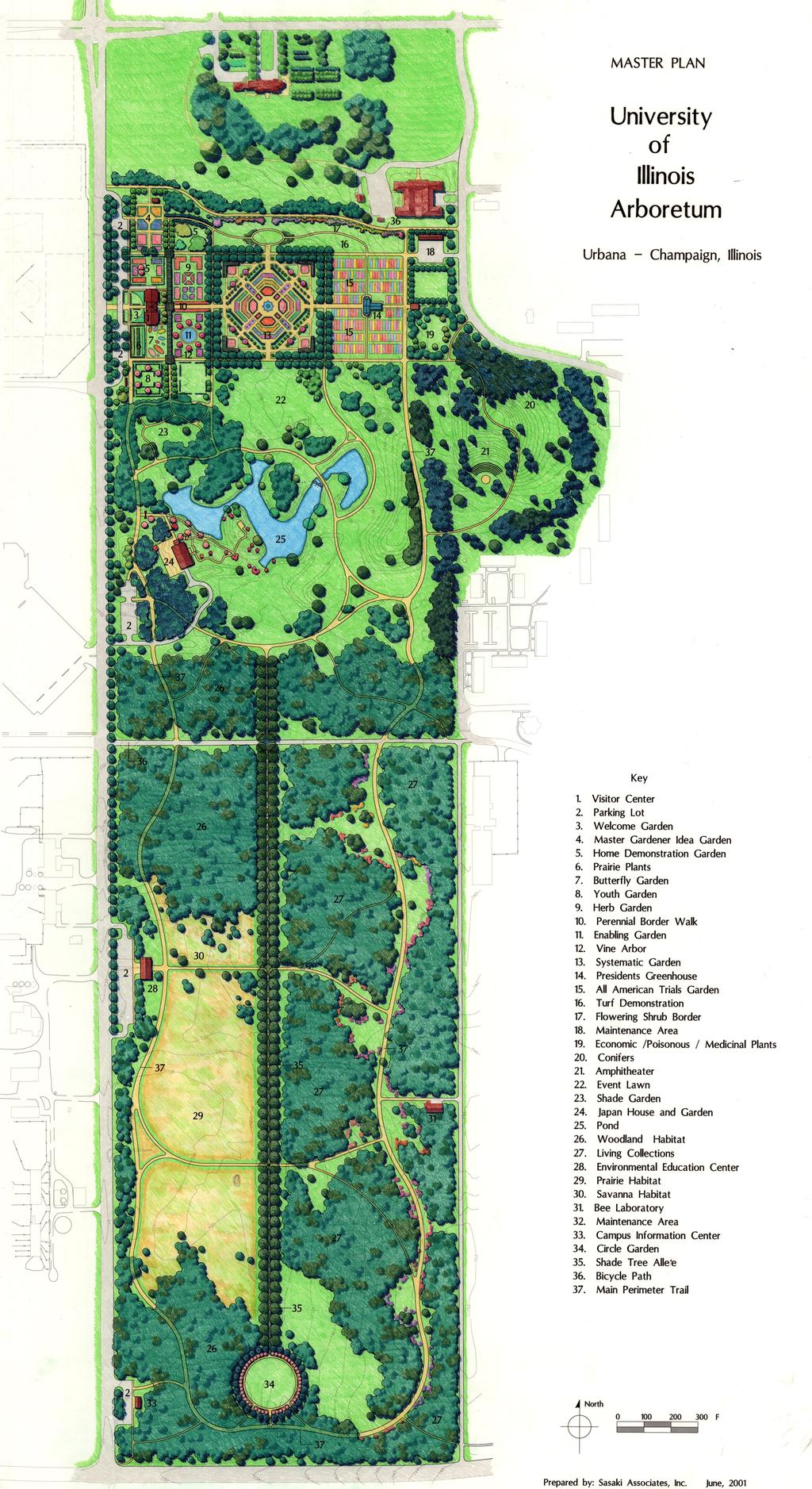
1 Arboretum Design Guidelines University of Illinois Arboretum Prepared by Sasaki Associates, Inc June 2001
2 The design guidelines for the University of Illinois Arboretum are intended to encourage a unified approach to the phased implementation of the Arboretum. The guidelines are a companion set of performance criteria to the 2001 updated Master Plan. The guidelines are organized to reflect the three major parts of the Arboretum the Core Gardens Area, the Pond Area, and the Collections Area. 1.0 THE CORE GARDENS AREA This area is the northernmost part of the Arboretum and contains the Visitor Center and a series of garden areas organized around the existing Hartley Garden. The area extends from Lincoln Avenue east to Orchard Drive, and from the President s House property south to St. Mary s Road extended. 1.1 Core Gardens Area Space Organization: The primary organizing ideas for the Core Gardens Area are as follows: Consistent with the original 1990 Arboretum Master Plan, the Core Gardens Area consists of a series of square and rectangular garden units aligned with the surrounding street grid. The Hartley Garden is an established element that is framed with a double row of Lindens and corner trellises. The overall character of this part of the Arboretum should be that of rich and varied gardens set within a geometric frame of paths, structures and framing plants Future garden paths, parking, structures, buildings and framing vegetation should conform to the grid structure established by the Hartley Garden. The exception to this is the vegetation frame along the President s House boundary, which may depart from the structural geometry. The purpose of employing the grid as a landscape structuring device is to ensure a unified order for the Core Gardens Area, make efficient use of the land, maintain a compact configuration and reasonable walking distances among the Core Gardens Area, facilitate easy wayfinding, and facilitate efficient irrigation and utility distribution systems. The subscription to a geometric garden structuring system is in no way intended to suggest that the garden designs within the rooms defined by the primary organizing paths, buildings, structures and frame plantings need to be geometric. Individual garden designs within the areas defined by the organizing paths, buildings, structures and frame plantings may be highly varied and responsive to individual garden program requirements and designer creativity Core Gardens Area frame planting and garden structures should be employed to visually define and frame individual garden areas. The degree of separation among the gardens will be determined on an individual basis. For example, a hedge may suffice to separate gardens in some cases, whereas other gardens may require a row of small trees or a trellis to adequately achieve the visual quality objectives of each garden. The design objective is to have the gardens perceived as individual and distinctive gardens unified by their overall organization and the treatment of their edges. The unifying role of the framework should not be ignored. Sasaki Associates, Inc. Page 1
3 1.1.4 It is recommended that, on the east side of the Visitor Center, a north-south trellis or other space-defining element be developed to create separation between the gardens associated closely with the Visitor Center and parking area, and those to the east. This will help create a pleasant sequence of spaces and landscape interest between the parking area and the Hartley Garden. 1.2 Core Gardens Area Circulation: The primary paths of the Core Gardens Area should be laid out in accordance with the updated Master Plan. A system of secondary paths may be developed within the gardens. The paths should be designed to accommodate both visitors and service vehicles Space should be provided along the north boundary of the Core Gardens Area for a shared use bicycle and pedestrian path. The path should be separate from paths used by garden visitors Parking for the Core Gardens Area should be located parallel and adjacent to Lincoln Avenue. Immediately east of the parking, the Visitor Center should be centered on the Hartley Garden. The primary garden access point should be at a Welcome Center in front of the Visitor Center, however, secondary access points should link the parking with the gardens north and south of the Visitor Center. 1.3 Core Gardens Area Land Use: Parking should be kept peripheral on the west edge of the Core Gardens Area The area designated for the Master Gardener Idea Garden in the Master Plan is based on the idea of incorporating and building upon the existing Master Gardener area. This area also requires close proximity to parking The area west of the Hartley Garden should be reserved for gardens that will have the highest appeal to public and campus audiences. Their location near parking and Lincoln Avenue will provide for convenient access The area east of the Hartley Garden should be reserved for gardens with lower all-season appeal to public audiences. These include the trials garden, poisonous plants area, and possibly a youth garden. The maintenance area should be located on the east side of the Core Gardens Area on Orchard Drive The north edge of the Core Gardens Area should be reserved for lawn and flowering shrub displays, which can serve as an informal buffer between the gardens and the bicycle path The Master Plan shows several garden areas that are undesignated for use. These areas may be used for future garden types that are yet to be defined. Sasaki Associates, Inc. Page 2
4 2.0 THE POND AREA This area includes the pond and the landscape around it, extending from Lincoln Avenue to Orchard Drive, and from the south edge of the Hartley Garden south to the north end of the Allée. 2.1 Space Organization for the Pond Area: The primary organizing ideas for the Pond Area are as follows: With the exception of the Lincoln Avenue edge where a formal row of street trees is proposed, the order of the plantings within the Pond Area should be informal and naturalistic. This approach is consistent with the existing patterns of trees in the Illini Meadows area and on the small hill near Orchard Drive. The overall character of this part of the Arboretum should be a parkland of spacious lawns surrounded and accented by masses of beautiful trees Trees and shrubs should be massed to frame open lawn areas to the north, south and east of the Pond. The Prairie School landscape idea of sun openings alternating with masses of mature trees casting shade should be developed. The spoil pile hill immediately east of the pond should remain open to maintain views from the hilltop. West and north of Japan House, tree planting should be denser to create a wind barrier, provide visual backdrop for Japan House, and to screen Lincoln Avenue and nearby parking The gardens at Japan House should be designed to relate to the building. Garden walking sequences and views should be considered primarily from the perspective of the house and its immediate outdoor porches and viewing stations. Planting on the east side of the Pond and on the conifer hill should be designed with an understanding of its role in the composition of views from Japan House Conifers should be massed along the Orchard Drive edge to provide a visual edge to the Arboretum The center of the lawn immediately north of the Allée should be free of trees between the Allée and the Pond. This will provide an appropriately spacious feeling at the north end of the Allée and a filtered visual connection across the Pond to the Hartley Garden Lindens. 2.2 Pond Area Circulation: Two primary paths should link the Core Gardens Area, through the Pond Area, to the Arboretum to the south. The two primary north-south paths should be located east and west of the Pond, be curvilinear in character and be fitted to the existing contour of the land. The paths should be designed to serve as the primary service vehicle route as well as the primary pedestrian path Secondary cross connector paths should be developed between the two primary paths. The connector on the south side of the Pond should reach its southernmost apex at the Allée. Sasaki Associates, Inc. Page 3
5 2.2.3 The access to Japan House should be from the west, through a series of garden gates between the primary path and Japan House. Access to Japan House from the east should be discouraged. It is recommended that the gardens around Japan House be developed in association with the building and experienced from that perspective and sequence A path up the hill adjacent to Orchard Downs Apartments should generally conform to the lay of the land, and follow a smooth and gently curving alignment to the summit of the hill. 2.3 Pond Area Land Use: Parking should be confined to the area immediately adjacent to Lincoln Avenue An amphitheater should be developed on the south slope of the hill adjacent to Orchard Drive, taking advantage of the natural contour of the land Existing mature trees in the northwest corner of the Pond Area should be employed as the canopy for a shade garden. The shade garden is an important link garden between Japan House and the Core Gardens Area. Its size permits extensive collections and massing of shade-tolerant herbaceous and woody plants Service activity for Japan House should be confined to the south side of the building and screened from view. 3.0 THE COLLECTIONS AREA The Collections Area consists of the area between the Pond Area and Windsor Road. It is defined on the east by an existing farm road and on the west by Lincoln Avenue. 3.1 Collections Area Space Organization: The primary organizing ideas for the Collections Area are as follows: The Collections Area is divided along a central north-south line into an East Area and a West Area. The center dividing line is to be developed as a powerful treelined avenue, or Allée. The overall character of the Collections Area will be naturalistic both east and west of the axis, and dramatically formal along its center axis in the fashion of the grand avenues of trees that grace such world-renowned naturalistic parks as Kensington Gardens in London and Central Park in New York City The Allée should be planned and planted with the long-term effect in mind. That effect should be of a grand and awe-inspiring avenue of trees, powerful in its scale and unity. It is the landscape element that will tie together half a mile of Arboretum collections. It needs to be bold and clear. The grand Elms of the early 20 th century along Burrill Avenue from the Union to Mumford House are a comparable example of the unambiguous effect that is sought. Sasaki Associates, Inc. Page 4
6 The Allée trees should be approximately forty feet apart east-west and northsouth. The area beneath the tree canopy should be lawn. The trees employed should be monocultures for each of the four segments of the Allée defined by crossing paths. The trees employed should be deciduous and capable of reaching large size. Based on stature and form, potential Allée trees include: Sugar Maple Hackberry Honeylocust Black Walnut Tulip Poplar Sycamore Bur Oak White Oak Chinkapin Oak Swamp White Oak Silver Linden American Elm (Valley Forge or New Harmony) It is understood that in youth the trees will be branched low, however, as they mature and their canopies overlap, the interior branches will be shaded out and removed. The long-term result will be an open space corridor between a colonnade of trees stretching for the full length of the Allée. At the south end of the Allée, a circular garden should be developed as the terminal space that receives and resolves the central corridor space of the Allée. An outer ring of large coniferous trees such as Norway Spruce and an inner ring of flowering trees such as Crabapples is recommended. At the points along the Allée where paths cross the axis, simple development of benches or seat walls should take place. The purpose of such elements will be to provide places to sit at key nodes along the Allée without interrupting the continuity of the open space corridor. The importance of maintaining the clarity and simplicity of the Allée and Circle Garden cannot be overstated. These elements, in time, will be among the most memorable iconic landscapes on the campus East of the Allée, the collections of woody trees and shrubs should be planted in masses that become more open along the pathways. The pathway openings will create linear serpentine spaces of varying width that will offer unlimited opportunities for attractive sequences, views and plant combinations. Sun-loving flowering plants may be emphasized along the edges of the spaces. Some areas within the denser tree plantings may eventually be allowed to evolve to a leaf mulch ground plane. Lawn maintained at a coarse height would be continuous along the pathways. Sasaki Associates, Inc. Page 5
7 3.1.4 West of the Allée, the Collections Area will consist of naturalistic communities of plants composed to replicate the character of woodlands, savanna and prairie landscapes. A plant buffer should be developed along the Lincoln Avenue edge to provide visual separation and a shelterbelt. The buffer should be composed of native trees and shrubs that would naturally occur at prairie edges. 3.2 Collections Area Circulation: The primary paths of the Collections Area shall consist of the Allée path, two other major north-south paths, and several east-west paths connecting the three north-south paths as shown on the updated Master Plan. Paths should be designed to accommodate both visitors and service vehicles With the exception of the Allée path and Hazelwood Drive extended, all of the paths should be curvilinear in their alignment The points at which the east-west paths cross the central Allée path should be synchronized to occur at topographic high points along the Allée path The path at Hazelwood Drive extended should be designed as a shared use path for bicycles and pedestrians Parking should be kept to the west perimeter of the Collections Area in two locations. One parking area is to be located in the south and be combined with a Campus Information Center. Another should be located near the proposed Environmental Education Center Service road connections should be made at proper functional intervals between the farm road along the east edge of the Collections Area and the primary northsouth path on the east side of the Collections Area. 3.3 Collections Area Land Use: Parking should be limited to the Lincoln Avenue edge. The south parking area should be developed in association with a Campus Information Center The Bee Laboratory should remain in its present location The Environmental Education Center should be located along Lincoln Avenue. This location will allow for public visibility, access and convenient proximity to available parking The west side of the Collections Area should be devoted to native plant collections composed to replicate natural communities. The north and south extremes of the West Collections Area should be devoted to woodlands. The central section of the West Collections Area should be devoted to prairie and savanna communities. Sasaki Associates, Inc. Page 6
8 3.3.5 The east side of the Collection Area should be devoted to woody plant collections composed by genera, family or other systematic method deemed appropriate to the teaching, research and outreach purposes of the collections. The difference between the East Collections Area and the West Collections Area is that the west area is organized to replicate natural communities and the east is not. The east area may include a broader range of introduced genera and species that would not be appropriate in the west area. mch\g:\ \admin\r-arboretum11_16.doc Sasaki Associates, Inc. Page 7
9
Physical Structure. This historic image from 1882 emphasizes the dramatic topography that distinguishes Cornell s setting at the top of East Hill.
 Physical Structure The natural, agrarian and urban setting for Cornell s campus is a precious resource to protect and enhance. It has also shaped the physical structure of the campus. Buildings, roads
PUBLIC RIGHT-OF-WAY IN THIS CHAPTER PUBLIC REALM
 PUBLIC RIGHT-OF-WAY This section provides design guidelines for improvements in the public right-of-way. The public right-of-way refers to streets, sidewalks, non-vehicular thoroughfares, parks and greenways
The Anaheim Resort Public Realm Landscape Program. City of Anaheim. Adopted September 1994 (94R-239)
") Public Realm Landscape Program City of Anaheim Adopted September 1994 (94R-239) Amendment No. 1 October 1996 (96R-178) Amendment No. 2 June 1999 (99R-137) Amendment No. 3 February 2001 (2002R-56) Amendment
Public Realm Landscape Program City of Anaheim Adopted September 1994 (94R-239) Amendment No. 1 October 1996 (96R-178) Amendment No. 2 June 1999 (99R-137) Amendment No. 3 February 2001 (2002R-56) Amendment
13. New Construction. Context & Character
 13. New Construction Context & Character While historic districts convey a sense of time and place which is retained through the preservation of historic buildings and relationships, these areas continue
EXISTING VEHICULAR & PEDESTRIAN CIRCULATION
 46 EXISTING CONDITIONS EXISTING VEHICULAR & PEDESTRIAN CIRCULATION Vehicular and pedestrian circulation patterns are illustrated on this graphic. Campus entry points and major vehicular circulation routes
SIUE LANDSCAPE UPGRADE
 SIUE LANDSCAPE UPGRADE Project Introduction The Southern Illinois University Edwardsville campus was established and built in the mid-1960's, based on a landscape master plan by HOK. The landscape plan
EXISTING CONDITIONS 41. Existing Conditions
 EXISTING CONDITIONS 41 Existing Conditions The Existing Analysis phase of the planning process involved a study of the existing conditions on the campus in order to identify key planning issues to be addressed
Georgeson Botanical Garden Master Plan
 Georgeson Botanical Garden Master Plan Alaska Chapter 2018-03-12 This Master Plan was developed by volunteers representing the Alaska Chapter of the American Society of Landscape Architects. Eliza Bober
3.1 community vision. 3.3 required plan elements
 Chapter 3 Community Form 3.1 community vision 3.2 Parks & landscaping concepts 3.3 required plan elements D R A F T 20 Community Form Chapter 3 3.0 Community form 3.1 community vision The Specific Plan
Designing a Water-Wise Garden. Design Goals. Feel Your Space. Before 2/26/2015
 Designing a Water-Wise Garden Patti Handfinger Master Gardener Design Goals it works in our environment it s beautiful it fits your site it keeps you healthy 1 2 Before Feel Your Space the breezes the
Design Principles, Design Guidelines, and Standing Review Committees for The Arboretum at Penn State
 Design Principles, Design Guidelines, and Standing Review Committees for The Arboretum at Penn State This document was prepared at the request of Kim Steiner, Arboretum director, by an Arboretum Design
Granite Belt Arboretum Australia
 The design principles and guidelines of Granite Belt Arboretum Australia are outlined in this document. They encompass environmental, social and economic sensitivities with the prime focus of creating
public review draft Key objectives for this chapter are:
 5 - parks & open space Providing a rich collection of outdoor places for informal gathering and recreation, as well as planned promotional activities and community events, is a key concept for Midtown.
Glenborough at Easton Land Use Master Plan
 Public Facilities 102 7.0 PUBLIC FACILITIES 7.1 OVERVIEW This chapter describes the public facilities that will provide high-quality services in the Glenborough at Easton community, to include three schools,
Seneca Meadows. Block 4 Locate office, technology, and medical development adjacent to I Screen views of garage structures from I-270.
 Seneca Meadows Seneca Meadows has an industrial park in its southern end and a mixed-use employment area planned for the north end. The district benefits from extensive I-270 visibility, stream valley
Purposes and Uses of Hedges
 Hedge s Purposes and Uses of Hedges Form a barrier or division Mark boundaries Provide privacy Background to garden displays Give design emphasis Separate one area from another where desirable General
section five BEAUTIFICATION PLAN
 section five BEAUTIFICATION PLAN BEAUTIFICATION PLAN Section Five Beautification Plan The goal of the Beautification Plan is to improve the Route 8-Sunnyland Corridor in terms of aesthetics and to create
Lecture 4 Circulation MoveMent through Space
 Islamic University-Gaza Faculty of Engineering Architecture Department Principles of Architectural and Environmental Design EARC 2417 Lecture 4 Circulation MoveMent through Space Instructor: Dr. Suheir
Lecture 8 OPENINGS &ORGANIZATION OF FORM AND SPACE
 Islamic University-Gaza Faculty of Engineering Architecture Department Principles of Architectural and Environmental Design EARC 2417 Lecture 8 OPENINGS &ORGANIZATION OF FORM AND SPACE Instructor: Dr.
Principles of Landscaping
 Principles of Landscaping 1. Definition of Landscaping Landscaping is a branch of horticulture and is an important field in which architecture, art and knowledge are combined to achieve beauty and utility.
Landscape and Streetscape Design 2.5
 Landscape and Streetscape Design 2.5 2.5.1 Goals 2.5.2 Planting 2.5.3 Sidewalks and Pavement 2.5.4 Furnishings 2.5.5 Walls 2.5.6 Lighting 2.5.7 Stormwater 2.5.8 Street Cross Sections 2.5 LANDSCAPE AND
AIRPORT BUSINESS PARK
 PIER MAC PETROLEUM INSTALLATION LTD. AIRPORT BUSINESS PARK DEVELOPMENT APPLICATIONS March 2003 4.1 Airport Business Park Development Permit Area 4.1.1 Justification/Design Concept The design concept envisioned
IV.63 Heritage Landscapes LLC, Preservation Landscape Architect & Planners
 Chapter IV: Landscape Units & Character-Defining Features Figure IV.1: This 1905 image north to Allison D shows shrubs east and southeast of the building. CDF Code T13c. Courtesy National Archives. (R-STE-DC0074SE0P003.jpg)
St. Elizabeths Hospital/West Campus Landscape Character-Defining Features
 The following list of landscape character-defining features is taken directly from Chapter VII of the 2007 St. Elizabeths West Campus Cultural Landscape Report by Heritage Landscapes and Robinson & Associates,
LANDSCAPE DESIGN AND INSTALLATION Lesson 20: DESIGN PROCESS
 LANDSCAPE DESIGN AND INSTALLATION Lesson 20: DESIGN PROCESS Script to Narrate the PowerPoint, 20_PowerPoint_Proc.ppt It is not permitted to export or reuse any images in the PowerPoint presentation. PowerPoint
Clovis Urban Greening Plan. Community Workshop #2 Northwest
 Clovis Urban Greening Plan Community Workshop #2 Northwest Thursday, October 9, 2014 WHAT IS AN URBAN GREENING PLAN? A guide to help the City to improve quality of life for residents Identification of
5.1.1 The streetscape along US Highway 64 (Brevard Road); and, The built environment within new residential developments; and,
; and, The built environment within new residential developments; and,") Article 5. Landscaping 5.1 Purpose The Town of Laurel Park s landscape standards are designed to create a beautiful, aesthetically pleasing built environment that will complement and enhance community
Article 5. Landscaping 5.1 Purpose The Town of Laurel Park s landscape standards are designed to create a beautiful, aesthetically pleasing built environment that will complement and enhance community
ALTERNATIVE STATION AREA -
 ALTERNATIVE STATION AREA - THE 10 TH STREET GARDEN STATION Two alternative land use scenarios and designs are illustrated here: Scheme A - Transit-Oriented Development High to Mid-Density Residential /Office
LANDSCAPE RESOURCE SURVEY
 LANDSCAPE RESOURCE SURVEY Campus Heritage Landscape Plan Eugene, Lane County, Oregon Spring 2007 n RESOURCE IDENTIFICATION & SUMMARY LANDSCAPE AREA NAME (o) Historic name(s) none known campus plan designation
Elements and Principles of Landscape Gardening
 Elements and Principles of Landscape Gardening Elements Line Colour Texture Habit Form Light Space or Volume Mobility Style Principles Simplicity Unity or Harmony Balance Proportion or Scale Accent or
Design Specifications & Requirements Manual
 11 PARKS & OPEN SPACES 11.1 DEFINITIONS... 1 11.1.1 Neighbourhood Parks... 1 11.1.2 District Parks... 1 11.1.3. Sport Parks... 1 11.1.4 Urban Parks... 1 11.1.5 Civic Spaces... 1 11.1.6 Open Space System...
CHAPTER 3. Design Standards for Business, Commercial, Industrial, Recreational and Institutional Uses
 CHAPTER 3 Design Standards for Business, Commercial, Section Number Title Ordinance Number Date of Ordinance 16-3-1 Applicability 2006-11 2008-04 07-01-08 16-3-2 Uniform Standards for Architectural Design
MILL POND OVERLOOK. A project of the Town of Oyster Bay. Prepared by Cameron Engineering & Associates, LLP
 MILL POND OVERLOOK A project of the Town of Oyster Bay Prepared by Cameron Engineering & Associates, LLP Funded in part through an EPF grant from the NYS Department of State Project Goals & Advisory Committee
Site Planning. 1.0 Site Context. 2.0 Pedestrian Circulation Systems. Pag e 2-23
 The following photographs from throughout the country illustrate key urban design principles. Photographs are provided to illustrate the overall urban design concepts described in Chapter 1 of the Downtown
Wide asphalt driveway abutting school property. garage built with incompatible materials, too close to park. incompatible fencing materials
 Wide asphalt driveway abutting school property incompatible fencing materials garage built with incompatible materials, too close to park Lack of plantings as a buffer between private property and open
2015 Campus Master Plan Update
 September 15, 2015 2015 Campus Master Plan Update Campus and Community Analysis Summary Presentation A G E N D A 1. Scope & Schedule of the Master Plan 2. Planning Principles & Draft Goals 3. Background
B L A C K D I A M O N D D E S I G N G U I D E L I N E S for Multi-family Development
 B L A C K D I A M O N D D E S I G N G U I D E L I N E S for Multi-family Development Adopted June 18, 2009 This section of the Design and focuses on site planning and design guidance for new multi-family
Infill Residential Design Guidelines
 Infill Residential Design Guidelines Adopted March 23, 2004 Amended September 10, 2013 City of Orange Community Development Department Planning Division Phone: (714) 744-7220 Fax: (714) 744-7222 www.cityoforange.org
Landscape Design Requirements and Guidelines for Private Lots in the Old Town North Neighborhood
 Landscape Design Requirements and Guidelines for Private Lots in the Old Town North Neighborhood July 2009 Prepared for High Country Management on behalf of the OTN Homeowners Association, by Christine
WESTERN ILLINOIS UNIVERSITY
 WESTERN ILLINOIS UNIVERSITY Quad Cities Riverfront Campus Master Plan March 1, 2006 Preliminary Master Plan Total Site Build Out Western Illinois University Quad Cities Municipal Park Mississippi River
Design Specifications & Requirements Manual
 11 PARKS & OPEN SPACES 11.1 DEFINITIONS... 1 11.1.1 Neighbourhood Parks... 1 11.1.2 District Parks... 1 11.1.3. Sport Parks... 1 11.1.4 Urban Parks... 1 11.1.5 Civic Spaces... 1 11.1.6 Open Space System...
FRUITVALE TRANSIT VILLAGE (Phase 2) Residential Project
 Residential Project") FRUITVALE TRANSIT VILLAGE (Phase 2) Residential Project DEVELOPER: SIGNATURE PROPERTIES ARCHITECT: HKIT ARCHITECTS April 23, 2010 TABLE OF CONTENTS 3 Vision 4 Description of Site 5 Guiding Concepts 6
FRUITVALE TRANSIT VILLAGE (Phase 2) Residential Project DEVELOPER: SIGNATURE PROPERTIES ARCHITECT: HKIT ARCHITECTS April 23, 2010 TABLE OF CONTENTS 3 Vision 4 Description of Site 5 Guiding Concepts 6
Planning Board Briefing
 Planning Board Briefing Why Now? The Sector Plan Implementation Chapter States: Before Stage 1 begins, the following must occur: Approval of the Sectional Map Amendment. Approval of the Greater Lyttonsville
ATTACHMENT A. SILVERDALE DESIGN STANDARDS Amendments to the Waaga Way Town Center Chapter
 ATTACHMENT A SILVERDALE DESIGN STANDARDS Amendments to the Waaga Way Town Center Chapter Chapter 10. Waaga Way Town Center 10.1 Physical Identity Elements & Opportunities The Waaga Way Town Center includes
DESIGN GUIDELINES. Seattle Children s Major Institution Master Plan. Approved May 7, 2010
 Approved May 7, 2010 Contact: Todd Johnson, todd.johnson@seattlechildrens.org, (206)987-5259 A. MASTER PLAN... 3 A1.0 Context... 3 A1.1 Purpose of Design Guidelines... 3 A1.2 Design Guidelines... 4 B....
SYRINGA VALLEY SPECIFIC PLAN NARRATIVE
 SYRINGA VALLEY SPECIFIC PLAN NARRATIVE Introduction With this application, Pleasant Valley South LLC ( Pleasant Valley ) seeks the City of Boise s approval of a new Specific Plan Ordinance to be added
VEHICULAR AND PEDESTRIAN CIRCULATION
 This perspective sketch communicates the intended character and quality of a proposed streetscape design. Locate benches near a major intersection where people tend to gather. Seating and lighting provide
I. VISUAL/AESTHETICS/NEIGHBORHOOD CHARACTER. b. Existing Conditions Views from Kimball Avenue
 I. VISUAL/AESTHETICS/NEIGHBORHOOD CHARACTER 1. Existing Conditions a. View Of The Site From Area Roads Figures IV.I-2, I-3 and I-4 depict existing views from the Cross County Parkway, Central Park Avenue,
Tel: (705) Fax: (705)
 Fax: (705)") 521 and 525 Essa Road City of Barrie Tel: (705) 812-3281 Fax: (705) 812-3438 Email: INFO@IPSCONSULTINGINC.com 1 5 0 D U N L O P S T R E E T E A S T, S U I T E 2 0 1, B A R R I E O N T A R I O L 4 M 1 B
521 and 525 Essa Road City of Barrie Tel: (705) 812-3281 Fax: (705) 812-3438 Email: INFO@IPSCONSULTINGINC.com 1 5 0 D U N L O P S T R E E T E A S T, S U I T E 2 0 1, B A R R I E O N T A R I O L 4 M 1 B
Insects The Cutleaf Weeping Birch is recommended for the following landscape applications;
 Cutleaf Weeping Birch The famous Cutleaf Weeping Birch, features finely cut leaves and a very pronounced weeping habit of growth, one of the most popular accent trees of all time; keep it happy and stress-free
KEY MAP DEVELOPMENT PERMIT AREA MAP. Sunnymede North Sub-Area Plan
 Richmond Official Community Plan BROADMOOR AREA SUNNYMEDE NORTH SUB-AREA PLAN Bylaw 7100 Schedule 2.6C SUNNYMEDE NORTH SUB-AREA PLAN SUNNYMEDE NORTH SUB-AREA PLAN SUNNYMEDE NORTH SUB-AREA PLAN KEY MAP
PLANNING RATIONALE FOR THE PROPOSED RIVERSIDE SOUTH ELEMENTARY SCHOOL 715 BRIAN GOOD AVENUE, OTTAWA, ON
 PLANNING RATIONALE FOR THE PROPOSED RIVERSIDE SOUTH ELEMENTARY SCHOOL 715 BRIAN GOOD AVENUE, OTTAWA, ON Conseil des écoles publiques de l'est de l'ontario (CEPEO) French Public School Board TABLE OF CONTENTS
URBAN DESIGN BRIEF. April FREEPORT Street TOWNHOUSES. 711 FREEPORT St., LONDON
 URBAN DESIGN BRIEF April 2013 FREEPORT Street TOWNHOUSES 711 FREEPORT St., LONDON TABLE OF CONTENTS 1.0 Land Use Planning Context...... pg. 1 1.1 Subject Lands... pg. 1 1.2 Proposed Development... pg.
6 STANDARDS THAT APPLY TO ALL
 6 STANDARDS THAT APPLY TO ALL DEVELOPMENT PROJECTS WITH RESIDENTIAL USES This chapter presents standards that are applicable to all projects with residential uses. STANDARDS THAT APPLY TO ALL DEVELOPMENT
Subcampus Recommendations
 T he campus is is comprised of three major areas. These subcampus areas are known as WestCampus, South Campus, Campus Oakland and Drive East Campus. and Future East growth Campus. requires a Future careful
Landscaping and Landscape Architecture
 A. General Overview This planning and landscape section has been prep ared to provide Property Owners, Architects, Contractors, and Builders/Developers with important information related to the development
SECTION TWO: Urban Design Concepts
 SECTION TWO: Urban Design Concepts The Gardnerville Plan for Prosperity shapes economic opportunities presented by regional growth. The Urban Design Concepts provide policies and concepts for land use,
EXISTING COMPREHENSIVE PLAN
 EXISTING COMPREHENSIVE PLAN Town Center Land Use Element: V. LAND USE POLICIES Town Center Mercer Island's business district vision as described in "Your Mercer Island Citizen-Designed Downtown" was an
Whitby Campus Landscape and Arboretum Plan THE BUILDING OF THE CFF LANDSCAPE, STUDENT COMMONS AND ARBORETUM
 Whitby Campus Landscape and Arboretum Plan THE BUILDING OF THE CFF LANDSCAPE, STUDENT COMMONS AND ARBORETUM Base Plan March 2016 3 Year Plan and Immediate Actions The focus for the evolution of the Whitby
Tazewell Pike. Neighborhood Conservation Overlay District Design Guidelines
 Tazewell Pike Neighborhood Conservation Overlay District Design Guidelines Knoxville Knox County Metropolitan Planning Commission November 2, 2000 These design guidelines were: Adopted by the Knoxville
4.0 SOFT LANDSCAPING & PLANTING
 4.0 SOFT LANDSCAPING & PLANTING The purpose of this section is to describe the horticultural characteristics of Herbert Park. The history as well as the present condition of the planting is described.
UNIVERSITY OF OREGON OREGON BACH FESTIVAL CPC Presentation February 11, 2016
 UNIVERSITY OF OREGON OREGON BACH FESTIVAL CPC Presentation February 11, 2016 LARGE SCALE CAMPUS TRANSPORTATION SITE ARRANGEMENT BUILDING DESIGN Campus Trees Good Neighbor Main Gateways Open-Space Framework
United City of Yorkville 50/50 Parkway Tree Program
 United City of Yorkville 50/50 Parkway Tree Program Through the 50/50 Parkway Tree Program, the United City of Yorkville shares the cost of planting trees with homeowners. Residents simply choose the tree
GARDENS AND ESTATES HORTON COUNTRY HOUSE LONGCROSS ESTATE LA GRANDE MAISON SUDELEY LAWN BARN NEAR BRIXWORTH WINGROVE HOUSE
 Our garden and estate work encompasses both traditional and contemporary design, informed by our skills in historic landscape conservation, and has been consistently well received. We like to work closely
Landscape Design The Design Process
 Landscape purposes Landscape Design The Design Process Utilitarian Aesthetic Psychological Carol Brouwer, Ph.D. Design Process Design Process Phases Series of problemsolving and creative steps to develop
Landscape Design Guidelines
 Section 7: Landscape Design Guidelines seven section Landscape Design Guidelines Following are landscape guidelines specific to Milledgeville. This section provides guidance to property owners and the
ZONING ORDINANCE TOWNSHIP OF BELLEVUE EATON COUNTY, MICHIGAN
 ZONING ORDINANCE TOWNSHIP OF BELLEVUE EATON COUNTY, MICHIGAN SECTION 23.08 LANDSCAPE PLANTING A. All plant materials required by this Ordinance or an approved Site Plan shall be planted to completion within
VILLAGE OF SKOKIE Design Guidelines for Mixed-Use Districts NX Neighborhood Mixed-Use TX Transit Mixed-Use CX Core Mixed-Use
 VILLAGE OF SKOKIE Design Guidelines for Mixed-Use Districts NX Neighborhood Mixed-Use TX Transit Mixed-Use CX Core Mixed-Use TABLE OF CONTENTS CHAPTER 1 SITE DESIGN Purpose 1 CHAPTER 2 SITE DESIGN Streetscape
Woodland Conservation and the Master Plan
 1 WHAT IS A MASTER PLAN? A Vision for the Future of Your Community Woodland Conservation and the Master Plan Goals Objectives Strategies 2 How Will Your Community Look? TREE PRESERVATION AND THE MASTER
Design Elements & Principles. Landscape Curb Appeal Principles & Elements of Design COLOR. Elements Color Form Texture Line
 Design Elements & Principles Landscape Curb Appeal Principles & Elements of Design Carol Brouwer, Ph.D. Elements Color Form Texture Line Principles Order Unity Dominance Accent Repetition Interconnection
HALF MOON BAY CATHOLIC ELEMENTARY SCHOOL SITE PLAN CONTROL DESIGN BRIEF
 HALF MOON BAY CATHOLIC ELEMENTARY SCHOOL SITE PLAN CONTROL DESIGN BRIEF February 12, 2015 BRYDEN MARTEL ARCHITECTS INCORPORATED 1066 somerset street west, suite 200, ottawa, ontario K1Y 4T3 tel: (613)
RIVERSIDE DESIGN CD-1 GUIDELINES. Adopted by City Council August 9, 1983
 $1 City of Vancouver Land Use and Development Policies and Guidelines Community Services, 453 W. 12th Ave Vancouver, BC V5Y 1V4 F 604.873.7344 fax 873.7060 planning@city.vancouver.bc.ca RIVERSIDE DESIGN
97 Lea Bridge Road, Leyton, E10 7QL London Borough of Waltham Forest December 2015
 97 Lea Bridge Road, Leyton, E10 7QL London Borough of Waltham Forest December 2015 Public Realm and Landscape Proposals LEA BRIDGE ROAD, WALTHAMSTOW Public Realm & Landscape Proposals BDP(90)RPT001 December
WELLINGTON STREET WEST COMMUNITY DESIGN PLAN
 36 3.CDP POLICIES 37 Wellington Street West CDP Vision Statement 38 3.1 Introduction 3.1.1 Purpose The development of buildings and public spaces is influenced by a variety of factors over time. City of
THE LANDMARK PROJECT: ST. GEORGE CAMPUS BEFORE AND AFTER
 THE LANDMARK PROJECT: ST. GEORGE CAMPUS BEFORE AND AFTER The Landmark Project will reimagine the historic core of the St. George campus by creating dynamic, open spaces where students, faculty and the
AESTHETIC APPEARANCE. Design Guidelines for Grade-Separated Pedestrian, Cyclist and Equestrian Structures
 III. AESTHETIC APPEARANCE The aesthetic qualities of a grade-separated structure are as important as the specific design criteria. For example, a structure may be constructed to the exact criteria set
E. Natural areas include habitats such as wetlands, tidal marshes, waterways, natural drainage-ways, woodlands and grassland meadows.
 Adopted November 1999 I. Purpose A. The purpose of these guidelines is to assist in the design and layout of open space, as provided on developed lots within the District. The intent of these guidelines
Knot gardens gained popularity in England during the 16th and 17th centuries.
 Knot gardens gained popularity in England during the 16th and 17th centuries. A horticultural treat awaits you at the glorious Historic Gardens in Annapolis Royal, Nova Scotia. It is composed of various
3.13. Development Guidelines
 3.3 Landscaping Elements Landscaping should be used to frame and soften structures, define site functions, enhance the quality of the environment, and screen undesirable views. Safety, environmental impacts,
ELEMENT 16 - LANDSCAPE DESIGN GUIDELINES ELEMENT
 16 ELEMENT 16 - LANDSCAPE DESIGN GUIDELINES ELEMENT Goal 1 To establish an overall landscape character that provides: A pedestrian friendly environment that provides ample tree canopy and shade. An overall
How to Plan and Implement Outdoor Learning Environments
 How to Plan and Implement Outdoor Learning Environments Jesse Turner, PLA Design Coordinator Brad Bieber, MLA Design Associate College of Design, NC State University 2 Step 1: Assessment Existing Site
Unique. Livable. Connected. Sustainable. Anticipate and Manage Change. Variety of Housing Choices. Enhanced Arterial Corridors
 Neighborhood Vision The Old Town Neighborhoods are Unique, Livable, Connected, and Sustainable. As mature, established neighborhoods, many of the ideas and opportunities expressed by stakeholders in support
A Master Plan for High Park s Hillside Garden and other Ornamental Gardens: Recommendations from the High Park Natural Environment Committee
 www.highparknature.org mail@highparknature.org A Master Plan for High Park s Hillside Garden and other Ornamental Gardens: Recommendations from the High Park Natural Environment Committee September 2015
Central Library of Rochester and Monroe County Historic Monographs Collection
 Rochester PtlMfc Ubrary CHA^IiE^ E UOT C f ) I S motto is ^o-ufltaspiration in Landscape Development. Co preserve all natural beauty so far as is possible; to add to it wherever conditions require; and
There are five comprehensive goals that inform the Urban Design element at FIU. They are:
 3.0 URBAN DESIGN ELEMENT This Comprehensive Master Plan Update reflects the University s commitment to the refinement and extension of the base concepts earlier master planning efforts have created. FIU
DEVELOPMENT CONTROLS MEDICAL DISTRICT
 6.01. GENERAL DESIGN GUIDELINES A. Site Planning B. Architectural Design C. Medical Facility Signage & Lighting D. Exhibit 48. ARCHITECTURAL DESIGN CONCEPTS 6.02. MEDICAL FACILITY STANDARDS & GUIDELINES
3.0 master plan concept
 3.0 master plan concept 3.1 introduction The purpose of the Huron Church Road Master Plan Concept is to provide an overview of the Master Plan design process, identify preliminary streetscape installations
The open space system should provide connective elements, relate to natural resources, and enhance the suburban character of the landscape..
 The open space system should provide connective elements, relate to natural resources, and enhance the suburban character of the landscape.. Mixed-use and infill development should maintain or enhance
Commercial Development Permit Area
 City of Kamloops KAMPLAN Commercial Development Permit Area PURPOSE The purpose of this Development Permit Area (DPA) is to establish objectives and provide guidelines for the form and character of commercial
Design Considerations
 Essential to the development of a successful Master Plan for the Park Complex is input from the community that the park will serve. The community outreach component of the planning process included numerous
LANDSCAPING, SCREENING AND BUFFER AREAS
 ARTICLE 9 LANDSCAPING, SCREENING AND BUFFER AREAS 9.1 PURPOSE AND SCOPE. The landscaping, screening and buffer regulations, adopted and prescribed in this Ordinance, are found by the Village Council to
4.500 Preston Road Overlay District
 Section 4.500 Preston Road Overlay District 2004 Zoning Ordinance 4.500 Preston Road Overlay District (ZC 98-29; Ordinance No. 98-9-12) 4.501 Purpose To provide appropriate design standards for the use
Neighborhood Districts
 NEIGHBORHOOD DISTRICTS SEVEN MAIN DISTRICTS Neighborhood Districts While the Development Plan provides a broad-scale overview of the neighborhood, this section focuses on uses and relationships at the
PROTOTYPE DESIGN/INTRODUCTION
 PART III: PROTOTYPE DESIGN These concepts and guidelines described earlier were used to develop a prototype design for an emerging suburban area located west of the City of Milwaukee. This was done to
R STREET CORRIDOR NEIGHBORHOOD Site Plan and Design Review Supplemental Guidelines Checklist
 R STREET CORRIDOR NEIGHBORHOOD Site Plan and Design Review Supplemental Guidelines Checklist Applicant s Name: Project Address: Phone: Email: Applicant shall fill out the design guidelines checklist for
Berkshire Regional Planning Commission Clearinghouse Review Report
 August 19, 2013 SUBJECT: Reconstruction of Housatonic Street, Dalton, MA EOEA#: 15083 LOCATION: Dalton ESTIMATED COST: $8.1 million REVIEW TYPE: ENF PROPONENT: MassDOT and Town of Dalton COMMENTS DUE:
CGT visit to Godolphin 11 th May 2016
 CGT visit to Godolphin 11 th May 2016 The garden at Godolphin Is one of Cornwall s most important medieval gardens and is on the national Register of Parks and Gardens as II*. The Register summary states
SECTION V: DESIGN GUIDELINE EXAMPLES
 SECTION V: DESIGN GUIDELINE EXAMPLES Introduction The Syracuse Town Center is envisioned as an area that creates a sense of place, a community downtown. As such, the Town Center Committee recommended the
The Olympics The first sustainable Games.
 Case Study The Olympics 2012. The first sustainable Games. 1 Case Study: The 2012 London Olympics Date: Summer 2012 Athletes Village: When architects and landscapers working on plans for the Athletes Village
REDMOND CENTRAL CONNECTOR ART & DESIGN MASTER PLAN
 REDMOND CENTRAL CONNECTOR ART & DESIGN MASTER PLAN Redmond Central Connector Master Plan design principles principles make it redmond: past, present, future not just a place with art, a place that is art