7.0 Site Considerations
|
|
|
- Erin Newton
- 5 years ago
- Views:
Transcription
1 7.0 Site Considerations In this chapter we present ideas for site layout and design with particular attention to sustaining and maximizing the natural environment.

2
3 SITE CONSIDERATIONS 7.1 The School Site Site layout and design is just as important as the spatial relationships of the spaces within the building. Of course, many of the design decisions relating to site issues will vary according to the actual size, orientation and topography of the land. Still, no matter where it is located, the building should be carefully placed within its context and should also sensitively cooperate with the environment. Site considerations such as zoning, setbacks, building heights, lot coverage, landscape ordinances, and local building codes need to be incorporated into the overall site plan design. Although many building codes are similar in different areas each local jurisdiction usually has unique building and/or local requirements that may alter the building and zoning codes. The site design in this document is based on an allocation of approximately 72,000 square feet. The recommended size of an elementary school, per the State s Facility Guidelines is 10.0 developable acres plus one developable acre for each 100 students. The 10 acres include adequate space for bus drop-off and parking; service and loading area; staff, faculty, and visitor parking; parent drop-off area; play areas; walking trails; stormwater pond; and minor building expansion. The assumptions here are that the site is basically flat, and the buildings are located with a north-south orientation. Minimum acreage refers to usable acreage or acreage that can be developed. School site sizes may be larger or smaller than those outlined in the State Guidelines. For example, additional acreage may be necessary to: Accommodate community use of the facility and multiuse recreational facilities such as soccer and softball fields. Account for areas that cannot be built upon, such as steep slopes, wetlands, rights-of-way, easements, setbacks, buffers, or poor soils. Meet requirements imposed by local ordinances, i.e. restrictions governing land that cannot be disturbed within a development and the permitted amount of impervious service will affect the ultimate size of the site. Include landscaping and buffers. Other aspects to consider in siting a new school include natural geographic barriers, road patterns, and existing or non-existing infrastructure such as water, sewer, and roadways. School systems should actively pursue partner agreements with communities, parks and recreation departments, private developers, and business in an effort to maximize joint use of facilities. SITE CONSIDERATIONS 63


4 64 Students are more likely to prosper when their environment is conducive to learning. Welldesigned systems send a powerful message to kids about the importance their community places on education. ~The American Association of School Administrators 7.2 Site Design and the Environment The following are some suggestions that insure a focus on sustaining and maximizing the natural environment. We have also included ways in which the site itself might be integrated into the school curriculum. 1. Site layout should minimize disturbance to natural areas. Wherever feasible, these areas are to be used for outdoor learning locations. 2. Limit amount of impermeable paving by maximizing use of porous materials such as pavers, porous concrete, porous asphalt, turf pavers, etc. 3. Provide preferred parking spaces for hybrid and compact cars. 4. Promote planting and saving of trees to provide canopy coverage particularly near and within parking areas. 5. Site planning should maximize potential for pedestrian and bike access. 6. Site design and layout should include opportunities for improving the land through restoration of degraded ecological attributes such as streams or wetlands. These restored features can be used as outdoor teaching areas. 7. If areas/borders do not exist, create them. They should be composed entirely of native species plantings with drought tolerance, and should come from a local nursery source for proper genetic provenance. 8. Trees and shrubs should provide wildlife food source. Species selection should be based on geographic location. 9. The building should be located on the higher part of the site in order to take advantage of natural slopes for drainage. 10. Provide a variety of covered outdoor activity areas for shaded play and rainy weather. 11. Ensure that all areas are handicapped accessible. 12. The building should be laid on an east/west axis. This will allow most windows to be placed on the North/South side of the building, thus allowing the design to take advantage of natural light and air. This includes sizing the windows based on the orientation of the sun, and using natural breeze to help ventilate. 13. In order to lower construction cost and significantly reduce site disturbance, consider building size reduction, multi-story structures and shared use with other community organizations. 14. Local materials will bring local character to the design. Use of indigenous materials will reduce the cost of shipping materials to the site and the emissions associated with shipping. 15. Green products can contribute to a sustainable design, for example by creating retaining walls with vegetation bags to bring more green to the design and create more areas to treat stormwater. Fairfield Middle School Photo courtesy of Perkins Eastman Photographer: Woodruff/Brown


5 Bus Entrance Public Entrance Frontage Road Proposed 10-Acre Site Bus Parking Staff/Visitor Parking Bus Drop-Off Media Center Service Yard Gym/ Dining Admin Shared Support Pre-Kindergarten Cluster Common Area Outdoor Learning Environment Building Services Primary Cluster I Art/Music/ Science St. Ignatius School Photo courtesy of Perkins Eastman Photographer: Sarah Mechling Common Area Outdoor Learning Environment Primary Cluster II Storm Water Management Pond Access to nature is linked with development of imagination, independence and autonomy. Outdoor Learning Environment Assumed North SITE CONSIDERATIONS 65


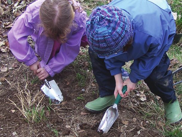
6 Student Engagement in Outdoor Play and Learning Outdoor spaces should be designed so children can test their abilities in an environment that offers challenge and stimulation. Children need tools, open space, and the opportunity to interact with the outdoor environment. Outdoor spaces help children grow up closely connected to nature. By being exposed to trees, plants, and other natural materials, children can independently discover nature and its processes. The outdoor environment should engage children s sense of inquiry, stimulate their imaginations, invite exploration, and support their developing competencies. An ideal outdoor area should be one that contains a variety of natural play and learning settings, offering children multiple opportunities to observe, explore, and interact with nature. An outdoor water exploration area would promote creativity, innovation, and exploration. Outdoor areas could also contain a variety of play and learning settings with constructed or manufactured elements that encourage physical activity. In addition to gross motor equipment, outdoor areas can promote arts and crafts, scientific and mathematical exploration, relaxation, quiet or dramatic play. In the FirstSchool Design Guide, it is suggested there be an outdoor learning area adjacent to each cluster of classrooms, promoting the outdoor learning experience related to the age group of each cluster. Outdoor opportunities should be designed for age appropriate learning experiences. Concordia International School Elementary School Photo courtesy of Perkins Eastman Photographer: Tim Griffith 1. Areas should be set aside for natural learning locations, perhaps named, for such things as vegetable production (organic), wildflowers, butterfly gardens, and rainwater harvesting. 2. Plant edible and re-seed gardens: These gardens will bring life and fun to the classroom. Re-seed gardens will allow students to learn nature s patterns. 3. The implementation of composting stations on-site will complete the planting cycle for the students. They will see how leftover food and yard debris can be used to fertilize their gardens. 4. Adventure Play Gardens (APG) give students not only the chance to play, but also a chance to bring lessons learned back into the classroom. APG allows students to explore and enhance their love for the outdoors. These playgrounds, though different from the typical schoolyard, give students a chance to mold, create, build, and manipulate many parts of their play area. APG allows children to take part in the things they love; crawling, digging, damming, and climbing. These spaces can be designed so that children will have plants and rocks to crawl under, soil and sand to dig in, water features to dam, and trees and other objects to climb. 5. Play areas that are responsive to the interests and skills of all young children (age 3 through 8), with attention to safety and supervision needs, facilitate cross-age interaction. The creation of these play spaces will also allow younger and older students to interact and learn from one another.


7 Outdoor Play and Learning Environment Common Area Outdoor Learning Environments Pre-K Common Area Outdoor Learning Environments Primary Cluster I Outdoor Learning Environments Primary Cluster II SITE CONSIDERATIONS 67


8 A Welcoming Environment One of the most important features of a school is the degree to which it fosters a sense of welcome and belonging for children and families. As a child approaches the school grounds and facility itself she/he should have a sense of being welcome. Buildings may seem imposing to young children and they can become easily overwhelmed with the size and scope of the space. Children should be able to easily negotiate the space. Doors should be easily opened by young children, pathways should be marked so that children not yet reading can find their way, displays should be placed at eye level for small children, and furniture should be available for young children in common areas as well as in their own classroom areas. The entry and other common areas should be familiar to children. They should see themselves and their families reflected in the art work, and depicted in school activities, photographs, and other displays in the school. The environment should inspire a sense of curiosity reflective of the school s attitude of inquiry as a core attribute of a successful school. Similarly, unless there is clear thought put into making a school friendly to adult family members, they too may feel uncomfortable entering a strange and imposing space. Having spaces specifically designed for use by family members that are clearly identified and easily accessible helps to let parents and other family members know that they are a welcome part of the school community and encourages them to become active in the life of the school. While the school must be designed to provide security for children at all times, this does not mean the spaces cannot be friendly to both children and adults as they enter the building. Indeed, a sense of safety is essential to a welcoming atmosphere.
Creating vibrant and healthy communities by transforming pavement into green space. Rose Bergeron Manager, Water Program, Depave Paradise
 Creating vibrant and healthy communities by transforming pavement into green space. Rose Bergeron Manager, Water Program, Depave Paradise Positive action for a green and healthy future Members across Canada:
COMMUNITY DESIGN. GOAL: Create livable and attractive communities. Intent
 COMMUNITY DESIGN Intent An attractive, well-designed County will attract quality development, instill civic pride, improve the visual character of the community, and create a strong, positive image for
Community Design Guidelines. Port Wallace DRAFT
 Community Design Guidelines Port Wallace DRAFT Energy 1 2 3 Nature Movement Connections Built Form DRAFT Layout Energy 1 Nature Community Design Guidelines GREAT COMMUNITIES PROTECT, CELEBRATE, AND CONSERVE
B L A C K D I A M O N D D E S I G N G U I D E L I N E S for Multi-family Development
 B L A C K D I A M O N D D E S I G N G U I D E L I N E S for Multi-family Development Adopted June 18, 2009 This section of the Design and focuses on site planning and design guidance for new multi-family
Rain Gardens. A Welcome Addition to Your Landscape
 Rain Gardens A Welcome Addition to Your Landscape Where Does The Rainwater Go? Naturally, forests provide a way for rainwater to percolate into the soil, filtering pollutants while trees are allowed to
Dowdy Park. Concept Plans TOWN OF NAGS HEAD NORTH CAROLINA. Developed by: Albemarle & Associates, Ltd VHB/ Vanasse Hangen Brustlin, Inc.
 TOWN OF NAGS HEAD NORTH CAROLINA Concept Plans Developed by: Albemarle & Associates, Ltd VHB/ Vanasse Hangen Brustlin, Inc. Site Looking Southeast Dowdy Park Existing Conditions Nags Head Woods Sound Future
Neighborhood Districts
 NEIGHBORHOOD DISTRICTS SEVEN MAIN DISTRICTS Neighborhood Districts While the Development Plan provides a broad-scale overview of the neighborhood, this section focuses on uses and relationships at the
STREAM BUFFERS
 88-415 STREAM BUFFERS 88-415-01 PURPOSE In the Kansas City region and throughout the nation, vegetated stream buffers have been clearly shown to protect stream stability and related infrastructure, improve
CAL POLY MASTER PLAN UPDATE, March 2015
 Some Key Themes in the General Guiding Principles Academic Mission The plan must foremost advance the University s academic mission and student success. Foresight and Adaptability The plan should take
CITY OF VIRGINIA BEACH PLANNING COMMISSION DESIGN AWARDS PROGRAM 2012
 Virginia Beach City Public Schools COLLEGE PARK ELEMENTARY SCHOOL CITY OF VIRGINIA BEACH PLANNING COMMISSION DESIGN AWARDS PROGRAM 2012 NOMINATION APPLICATION SUSTAINABLE DEVELOPMENT PROJECT NARRATIVE
Conservation Development
 Acknowledgements RIDEM: Scott Millar Anthony Lachowicz-Planning and Zoning Consultant Director of Planning 1 : a creative land use technique that allows a community to guide growth to the most appropriate
ANCHORAGE PARK REPORT CARD Assessing A Park s Appearance, Function, & Condition
 ANCHORAGE PARK REPORT CARD Assessing A Park s Appearance, Function, & Condition Park Name: Is Your Park an A or an F? Your Name: Contact Information Optional: Date: General Instructions: Phone: Email:
Duplex Design Guidelines
 Duplex Design Guidelines Adopted by Council May 29, 2006 Prepared By: Table of Contents 1.0 Application and Intent 1 2.0 Areas of Application 2 3.0 Design Principles 3 4.0 Design Guidelines 4 4.1 Site
Principles for Ecological Landscape Design in Brownfield Business Parks
 Principles for Ecological Landscape Design in Brownfield Business Parks Part of USDA Forest Service research project # 00-JV-11231300-033: Aligning Social and Ecological Drivers of Urban Landscape Change
Toronto Complete Streets Guidelines
 Toronto Complete Streets Guidelines 108 110 7.1 Green Infrastructure Design Principles 112 7.2 Context-Sensitive Green Streets 114 7.3 Key Green Street Elements Green infrastructure refers to natural and
Exhibit A. 8:9 Scuffletown Rural Conservation District
 Exhibit A 8:9 Scuffletown Rural Conservation District 8:9.1 Intent and Purpose The Scuffletown Rural Conservation (SRC) District is intended to provide for residential development that supports the development
GUIDING PRINCIPLES IN THIS CHAPTER
 GUIDING PRINCIPLES The guiding principles and design concepts in this chapter work together with the Chapel Hill 2020 Comprehensive Plan to support new public places that can be enjoyed by all while also
PUBLIC RIGHT-OF-WAY IN THIS CHAPTER PUBLIC REALM
 PUBLIC RIGHT-OF-WAY This section provides design guidelines for improvements in the public right-of-way. The public right-of-way refers to streets, sidewalks, non-vehicular thoroughfares, parks and greenways
Coffee Creek Park Development Low Impact Development (LID)
") Coffee Creek Park Development Low Impact Development (LID) City of Duluth, St. Louis County, MN Presented By: Christopher J. Rousseau, P.E. February 27, 2008 Developer / Owner Information Trinity Development
Coffee Creek Park Development Low Impact Development (LID) City of Duluth, St. Louis County, MN Presented By: Christopher J. Rousseau, P.E. February 27, 2008 Developer / Owner Information Trinity Development
Proposed for Vic West Neighbourhood Plan. Design Guidelines for Intensive Residential Development - Townhouse and Attached Dwelling
 Proposed for Vic West Neighbourhood Plan Design Guidelines for Intensive Residential Development - Townhouse and Attached Dwelling Design Guidelines for Intensive Residential Development - Townhouse and
PART 1: PROJECT SUMMARY. The application is Attachment A. The site plan is Attachment B.
 Belleterre Subdivision Sketch Plan Town Board 8.7.17 Belleterre Subdivision Sketch Plan PART 1: PROJECT SUMMARY Applicant: Bowman Development Project Size: +/- 20.85 acres Parcel Number: 01115104 and 01115121
STORMWATER MANAGEMENT CODES ANALYSIS RICHLAND COUNTY, SC SITE PLANNING ROUNDTABLE
 STORMWATER MANAGEMENT CODES ANALYSIS RICHLAND COUNTY, SC SITE PLANNING ROUNDTABLE Codes analyses for each subcommittee were completed to assist participants of the Richland County Site Planning Roundtable.
Smart Growth Development Checklist
 2004 Smart Growth Development Checklist Smart Growth Development Checklist Corporation of the City of New Westminster Guide and manage growth in a manner which is consistent with the principles of sustainable
Chapter Master Planned Communities (MPC) District
 District") Sections 14.53.010 Purpose and Intent 14.53.020 Applicability 14.53.030 Procedure 14.53.040 MPC Standards 14.53.050 Required Findings 14.53.010 Purpose and Intent Chapter 14.53 Master Planned Communities
Sections 14.53.010 Purpose and Intent 14.53.020 Applicability 14.53.030 Procedure 14.53.040 MPC Standards 14.53.050 Required Findings 14.53.010 Purpose and Intent Chapter 14.53 Master Planned Communities
SITE FEASIBILITY TEST FIT LAYOUT NORTHERN AREA INTERNATIONAL SCHOOL DECEMBER 2016
 SITE FEASIBILITY TEST FIT LAYOUT NORTHERN AREA INTERNATIONAL SCHOOL DECEMBER 2016 OWNER & DESIGN TEAM GENERAL BACKGROUND INFORMATION PGCPS received a Carnegie Corporation Opportunity by Design grant to
Tennessee Stormwater Management Program. Stormwater Management Site Assessment and Inventory Checklist. Quick Check o Vicinity Map within Watershed
 Tennessee Stormwater Management Program Project Name: Location: File Number: Reviewer: Date of Submittal: Review Date: Project Meeting Chronology: Type of Meeting: Date: Stormwater Management Site Assessment
include playgrounds, sports fields, community gardens and picnic areas.
 DEVELOPMENT PLAN OPEN SPACE SYSTEM OPEN SPACE SYSTEM The neighborhood provides for a range of open space types. The Village Square is an important open space in the neighborhood. It serves as a gathering
Charles P. Johnson and Associates. Annapolis Landscape Architects
 Charles P. Johnson and Associates Annapolis Landscape Architects AGENDA Introduction Project Limits and Scope Site Analysis Opportunities & Constraints Program Goals Image Boards Design Alternatives Pros
IV. Development in the Rural Overlay District
 Intracoastal Waterway Route 17 Route 168 Great Dismal Swamp VIRGINIA NORTH CAROLINA IV. Development in the Rural Overlay District IV-1 Route 17 in Chesapeake s Rural Overlay District affords distant views
Section 3 Non-Structural BMPs
 3.1 Stream Buffers A stream buffer or stream setback is a designated area around a stream, lake, or wetland left in a natural, densely vegetated state so as to protect the receiving water quality and provide
Landscaping Standards
 CHAPTER 29 ARTICLE 403 29.403 Landscaping Standards Purpose: The purpose of this section is to protect and promote the public health, safety and general welfare by requiring landscaping in relation to
Appendix E: Illustrative Green Infrastructure Examples
 Appendix E: Illustrative Green Infrastructure Examples Integrating LID into San Francisco s Urban Landscape Figure E. High-density Residential Figure E. Low-density Residential Figure E. Mixed Use 7 Figure
Landscape Design. earth-wise guide to. earth-wise guide to
 earth-wise guide to earth-wise guide to Landscape Design The purpose of this fact sheet is to provide background information on creating a green garden for either the do-it-yourselfer of for those working
GUIDELINES FOR ECOLOGICAL PERFORMANCE
 3 Landscape........................................... 3.2 Stormwater Management................................... 3.3 Hardscape........................................... 3.4 Streetscape..........................................
Gifts to the Breaking New Ground
 Breaking New Ground Gifts to the Breaking New Ground effort will help Pilot provide a learning environment that seamlessly combines the wonders of the campus with the technology of the building. Meeting
BARD COLLEGE REGIONAL GREEN INFRASTRUCTURE DEMONSTRATION PROJECT A Case Study Addressing Stormwater Management for a Small Watershed
 BARD COLLEGE REGIONAL GREEN INFRASTRUCTURE DEMONSTRATION PROJECT A Case Study Addressing Stormwater Management for a Small Watershed Presenter: Barbara Z. Restaino, RLA, ASLA Restaino Design Landscape
RECREATION, OPEN SPACE AND GREENWAYS ELEMENT GOALS, OBJECTIVES, AND POLICIES
 RECREATION, OPEN SPACE AND GREENWAYS ELEMENT GOALS, OBJECTIVES, AND POLICIES GOAL R-1: DEVELOP A RECREATION, OPEN SPACE AND GREENWAYS SYSTEM AS AN INTEGRAL COMPONENT OF AN OVERALL, COUNTY-WIDE ECONOMIC
North Oakville East Parks Facilities Distribution Plan. November, 2009
 North Oakville East November, 2009 POLICY CONTEXT 1) Purpose a) The purpose of this document is to be a guide for the location, configuration, design and development of the parks system for the North Oakville
Sustainable Park Design at Oregon Hills Park
 Sustainable Park Design at Oregon Hills Park Conservation Reduce fuel needed for transportation: o This is a Neighborhood park and as such, is located within walking distance of the park user o Encourage
Ohlone College Measure G Project Scope Revisions
 Scope Revisions Current Title Revised Title Current Scope Revised Scope 6101 Relocated Baseball Field Athletic Fields Create new sustainable baseball field with synthetic turf, bleacher seating and batting
ZONING ORDINANCE FOR THE ZONED UNINCORPORATED AREAS ARTICLE 1150 OF PUTNAM COUNTY, WEST VIRGINIA Page 95 ARTICLE 1150 SITE PLAN REVIEW
 OF PUTNAM COUNTY, WEST VIRGINIA Page 95 1150.01 PURPOSE 1150.02 APPLICABILITY 1150.03 APPLICATION PROCESS 1150.04 REVIEW PROCESS 1150.05 REVIEW CRITERIA 1150.06 SITE PLAN GUIDELINES 1150.01 PURPOSE ARTICLE
Green Infrastructure and Low-Impact Development Technologies
 Green Infrastructure and Low-Impact Development Technologies The guiding principles of these technologies is to manage stormwater at their sources using natural means, and establish conditions so that
VEHICULAR AND PEDESTRIAN CIRCULATION
 This perspective sketch communicates the intended character and quality of a proposed streetscape design. Locate benches near a major intersection where people tend to gather. Seating and lighting provide
TABLE OF CONTENTS 1.0 INTRODUCTION GENERAL OBJECTIVES LAND USE DESIGNATIONS, OBJECTIVES AND POLICIES 4
 Schedule I- Redstone Golf Course Resort Area Sector Plan 1 TABLE OF CONTENTS 1.0 INTRODUCTION 3 2.0 GENERAL OBJECTIVES 3 3.0 LAND USE DESIGNATIONS, OBJECTIVES AND POLICIES 4 4.0 TRANSPORTATION AND ROAD
F. Driveways. Driveways which provide access to off-street parking or loading from public streets shall comply with the following:
 Section 20.945.040 General Design Standards for Surface Parking Areas. A. Review Authority. Parking lot design and drainage shall be subject to review and approval of the City Transportation Manager. B.
REZONING APPLICATION MPD SUPPLEMENT
 REZONING APPLICATION MPD SUPPLEMENT For Staff Use Only: DATE/TIMESTAMP: ZA# RECEIVED BY: The intent of the Master Planned District (MPD) designation is to allow flexibility in the design and construction
COMMUNITY DEVELOPMENT DEPARTMENT POLICY DRAINAGE FOR RESIDENTIAL PROJECTS WITH ONE OR TWO UNITS REVISED JANUARY 4, 2018
 COMMUNITY DEVELOPMENT DEPARTMENT POLICY DRAINAGE FOR RESIDENTIAL PROJECTS WITH ONE OR TWO UNITS REVISED JANUARY 4, 2018 A. California Residential Code Requirement - Construction plans shall indicate how
319 Grant: Baker Creek & Centenary Creek Restoration Initiative
 319 Grant: Baker Creek & Centenary Creek Restoration Initiative Objectives: Overview of Watershed Characteristics: Discussion of Project Tasks: Discussion of Watershed Management Plan: Presented by: Erich
2.1 Principles & Objectives
 Designing With The Landform 2.1 Principles & Objectives Land planning which integrates the natural features of a site (i.e., designing with the landform ) into the site design is a major component of the
Glenborough at Easton Land Use Master Plan
 Public Facilities 102 7.0 PUBLIC FACILITIES 7.1 OVERVIEW This chapter describes the public facilities that will provide high-quality services in the Glenborough at Easton community, to include three schools,
ARTICLE 6: Special and Planned Development Districts
 ARTICLE 6: Special and Planned Development Districts 6-10 Traditional Neighborhood Development (TND) District 6-10.10 Purpose and Intent The Traditional Neighborhood Development (TND) District provides
City of Vaughan Urban Design Guidelines for Infill Development in Established Low-Rise Residential Neighbourhoods
 City of Vaughan Urban Design Guidelines for Infill Development in Established Low-Rise Residential Neighbourhoods DRAFT - September 2016 Contents 1. Introduction 1 2. Policy Context 3 3. Characteristics
URBAN DESIGN BRIEF URBAN DESIGN BRIEF 721 FRANKLIN BLVD, CAMBRIDGE August 2018
 URBAN DESIGN BRIEF URBAN DESIGN BRIEF 721 FRANKLIN BLVD, CAMBRIDGE August 2018 DESIGN BRIEF CONTENTS PART A 1.0 INTRODUCTION 2.0 DESCRIPTION & ANALYSIS OF SITE CONTEXT 3.0 DESIGN CONSTRAINTS AND OPPORTUNITIES
Improve Neighborhood Design and Reduce Non Point Source Water Pollution
 HOW TO Planning Guide Improve Neighborhood Design and Reduce Non Point Source Water Pollution This document was funded by a grant from the New Hampshire Coastal Program with funding from the National Oceanic
More than 30 adults and 19 children were involved in these community workshops.
 Linwood Workshops held at Household of Faith Deliverance Church 3.29.08 and 4.05.08 What is a Design Workshop? We use the term workshop (often called charrette among design professionals) to describe a
Complete Neighbourhood Guidelines Review Tool
 Complete Neighbourhood Guidelines Review Tool Prepared By: City of Regina Planning Department October 2014 Page 1 of 14 Community Development Review Checklist for Secondary Plans and Concept Plans The
Section 4 - Public Realm & Landscape proposals Landscape Masterplan. Section 4 52
 - Public Realm & Landscape proposals Landscape Masterplan 52 Proposed Masterplan - Green Infrastructure Strategy District Park 4.33 Ha to provide Passive and active recreation with a large play area which
Goals & Objectives (best derived from an input
 Goals & Objectives (best derived from an input process) Goal - sets an intent of the project States the expected result or outcome of the project The trail will provide recreation and transportation opportunities
Pre-Event Activities. Capture that Rain! Pre-Field Trip Suggestions
 Capture that Rain! When it rains, it pours, creating storm water runoff and water quality problems in our region. Students will assist Ontario Municipal Utilities Company s Water Resources Coordinator
Figure 1. Proposed Strategic Habitat Conservation Areas for Florida
 Figure 1. Proposed Strategic Habitat Conservation Areas for Florida Critical Lands and Waters Identification Project (CLIP) Cooperative Effort Century Commission for Sustainable Florida Florida Natural
Design Specifications & Requirements Manual
 11 PARKS & OPEN SPACES 11.1 DEFINITIONS... 1 11.1.1 Neighbourhood Parks... 1 11.1.2 District Parks... 1 11.1.3. Sport Parks... 1 11.1.4 Urban Parks... 1 11.1.5 Civic Spaces... 1 11.1.6 Open Space System...
The Five Components of the McLoughlin Area Plan
 The Five Components of the McLoughlin Area Plan This documents contains the complete language of the five components of the McLoughlin Area Plan: The Vision Statement The Values The Guiding Principles
Create your own. Rain Garden
 Create your own Rain Garden July 2013 Sacramento County Rain Garden Guidelines What s so cool about rain gardens? Rain gardens are shallow, landscaped depressions that capture rain water that runs off
Play areas overlooking climbing hill. School & playgrounds overlooking pond bottom ballfields. Project experience while at Loris and Associates, Inc.
 City of Thornton Parks & Open Space Cherrywood Park Thornton, CO Architect: Design Concepts Construction of this seven-acre City park, located adjacent to Adams Twelve Five Star Prairie Hills Elementary
MULTIFAMILY RESIDENTIAL DESIGN PRINCIPLES Site Plan and Design Review Principles Checklist
 MULTIFAMILY RESIDENTIAL DESIGN PRINCIPLES Site Plan and Design Review Principles Checklist Applicant s Name: Project Address: Phone: Email: Applicant shall fill out the design guidelines checklist for
Planning Board Briefing
 Planning Board Briefing Why Now? The Sector Plan Implementation Chapter States: Before Stage 1 begins, the following must occur: Approval of the Sectional Map Amendment. Approval of the Greater Lyttonsville
Urban Stormwater: Best Practice Environmental Management Guidelines. CSIRO This electronic edition published by CSIRO PUBLISHING, 2006.
 Urban Stormwater: Best Practice Environmental Management Guidelines. Chapter 5 Water Sensitive Urban Design Key references Department of Planning, 1993, Better Drainage: Guidelines for the Multiple Use
CHAPTER FIVE COMMUNITY DESIGN
 CHAPTER FIVE COMMUNITY DESIGN CHAPTER FIVE - COMMUNITY DESIGN Assumptions Frazier Park and Lebec have historically developed according to different patterns of spatial form. While both communities are
APPENDIX G: TOWN ORDINANCE REVIEW
 APPENDIX G: TOWN ORDINANCE REVIEW TYLin (225740) Woodard & Curran SWMP January 2013 Stormwater LID strategies, ranked for Zoning Bylaw and Site Plan Review Standards Dimensional Requirements Permit the
FirstLine Schools: GARDEN TEACHING FELLOW
 FirstLine Schools: GARDEN TEACHING FELLOW Creating and inspiring great open admissions public schools in New Orleans Organization Information: In 1998, FirstLine Schools started the first charter school
3. VISION AND GOALS. Vision Statement. Goals, Objectives and Policies
 Vision Statement Queen Creek s interconnected network of parks, trails, open spaces and recreation opportunities provide safe and diverse activities and programs that sustain its unique, small town, equestrian
Gold Line Bus Rapid Transit Transit Oriented Development (BRTOD) Helmo Station Area Plan
 Helmo Station Area Plan") Appendix F Gold Line Bus Rapid Transit Transit Oriented Development (BRTOD) Helmo Station Area Plan Introduction and Purpose of the Plan The Gold Line Bus Rapid Transit facility is an eleven-mile dedicated
Appendix F Gold Line Bus Rapid Transit Transit Oriented Development (BRTOD) Helmo Station Area Plan Introduction and Purpose of the Plan The Gold Line Bus Rapid Transit facility is an eleven-mile dedicated
Programming Ideas for Parks Professionals
 Programming Ideas for Parks Professionals 6 How to Use this Information This is a list of ideas, suggestions and tips for promoting and incorporating the healthy in nature movement in your parks. Whether
The leader in physical activity for young children!
 The leader in physical activity for young children! Create an Outdoor Playground! Complete, cross-curricular playgrounds promote whole-child development! Ground-level and freestanding activities promote
EXISTING CONDITIONS 41. Existing Conditions
 EXISTING CONDITIONS 41 Existing Conditions The Existing Analysis phase of the planning process involved a study of the existing conditions on the campus in order to identify key planning issues to be addressed
PCAL Case Study Open Spaces: Blayney Heritage Park
 PCAL Case Study Open Spaces: Blayney Heritage Park Introduction Blayney Heritage Park is an area of high quality open space that offers a range of active and passive recreation facilities. The multi-purpose
Green Infrastructure Recommendations For Parks and Public Spaces
 Green Infrastructure Recommendations For Parks and Public Spaces Issued by the Jersey Water Works Green Infrastructure Committee And Prepared by Meliora Design This document recommends ways to integrate
When planning stormwater management facilities, the following principles shall be applied where possible.
 2.0 Principles When planning stormwater management facilities, the following principles shall be applied where possible. 2.0.1 Drainage is a regional phenomenon that does not respect the boundaries between
Working Group Meeting
 April 4,, 2017 Parks Operations Bldg Working Group Meeting Arts Districts Overview Stormwater/RPA/Stream Considerations First Principles Agenda 7:00pm 7:05pm 7:10pm 7:40pm 8:30pm 9:40pm 9:45pm Welcome
G. RECREATION AND OPEN SPACE ELEMENT. The following summarizes the Recreation and Open Space Element:
 G. RECREATION AND OPEN SPACE ELEMENT The purpose of the Element is to provide the framework and direction for a comprehensive system of public and private sites for recreation, including, but not limited
Landscaping and Landscape Architecture
 A. General Overview This planning and landscape section has been prep ared to provide Property Owners, Architects, Contractors, and Builders/Developers with important information related to the development
1. Parks & Recreation Neighborhood Parks Community Parks Special Use Sites 2. Open Space 3. Trails
 Appendix A: Park Classifications The intent of parks and recreation classifications is to aid in making acquisition and design decisions for park sites, facilities and the organization of recreation space
ARTICLE IV: DEVELOPMENT STANDARDS 404 MASTER PLANNING
 IV 13 404 MASTER PLANNING Master Planning through the Site Analysis (Master Planning Site Analysis) or Planned Development (Master Planning Planned Development) is provided to encourage development which
City of Langford Green Development Checklist
 City of Langford Green Development Checklist The following Green Development Checklist creates a sustainability standard for all comprehensive development within the City of Langford. The commitments made
NEIGHBOURHOOD DECISION MAKING NORTHWEST LONDON
 NEIGHBOURHOOD DECISION MAKING NORTHWEST LONDON Thank you for voting! Please use the paper provided to mark down the numbers of the idea you would like to vote for, and bring it to the voting station. VOTE
RAIN GARDENS. Task: PART 1 (60 minutes) Student Directions: Steps you will be following: Directions for beginning: Source Information:
 Student Directions: Steps you will be following: Directions for beginning: Source Information:") PART 1 (60 minutes) Student Directions: Your assignment: Steps you will be following: Your neighborhood council is researching the benefits of installing rain gardens in your community. You will read two
PART 1 (60 minutes) Student Directions: Your assignment: Steps you will be following: Your neighborhood council is researching the benefits of installing rain gardens in your community. You will read two
SECTION II SECTION II STATEMENT OF GOALS, OBJECTIVES, PRINCIPLES, ASSUMPTIONS, POLICIES AND STANDARDS
 STATEMENT OF GOALS, OBJECTIVES, PRINCIPLES, ASSUMPTIONS, POLICIES AND STANDARDS 1 2 STATEMENT OF GOALS, OBJECTIVES, PRINCIPLES, ASSUMPTIONS, POLICIES AND STANDARDS INTRODUCTION The New Jersey Municipal
Derry Green Corporate Business Park
 Town of Milton Derry Green Corporate Business Park Urban Design Guidelines BMI/Pace - June 2010 Draft 3 Prepared by: Brook McIlroy Planning + Urban Design / Pace Architects Suite 300-51 Camden Street Toronto,
Keyport. Vision for Keyport
 Keyport Vision for Keyport Keyport is a rural, historic waterfront village bounded and limited in size by its natural borders of water and the Naval Undersea Warfare Center. The community consists primarily
Chapter PEDESTRIAN COMMERCIAL (PC) ZONING DISTRICT
 ZONING DISTRICT") Chapter 11-17 PEDESTRIAN COMMERCIAL (PC) ZONING DISTRICT Sections: 11-17-01 GENERAL PURPOSE 11-17-02 PERMITTED BUILDING TYPES 11-17-03 USES PERMITTED WITH DESIGN REVIEW 11-17-04 USES PERMITTED BY CONDITIONAL
Chapter 11-17 PEDESTRIAN COMMERCIAL (PC) ZONING DISTRICT Sections: 11-17-01 GENERAL PURPOSE 11-17-02 PERMITTED BUILDING TYPES 11-17-03 USES PERMITTED WITH DESIGN REVIEW 11-17-04 USES PERMITTED BY CONDITIONAL
Table of Contents. To learn more about the Schools In Motion program, visit
 TOOLK I T Table of Contents Planning an accessible playspace... 3 Examples of good accessible design... 4 Project planning tips... 5 Consulting with playspace users... 6 Consulting with a playspace designer...
VILLAGE OF SKOKIE Design Guidelines for Mixed-Use Districts NX Neighborhood Mixed-Use TX Transit Mixed-Use CX Core Mixed-Use
 VILLAGE OF SKOKIE Design Guidelines for Mixed-Use Districts NX Neighborhood Mixed-Use TX Transit Mixed-Use CX Core Mixed-Use TABLE OF CONTENTS CHAPTER 1 SITE DESIGN Purpose 1 CHAPTER 2 SITE DESIGN Streetscape
VILLAGE OF CLEMMONS PLANNING BOARD DRAFT STAFF REPORT
 VILLAGE OF CLEMMONS PLANNING BOARD DRAFT STAFF REPORT PETITION INFORMATION Docket # C-226 Staff Megan Ledbetter Petitioner(s) JBJH Properties, LLC Owner(s) JBJH Properties, LLC Subject Property 5892-49-1766
Master Plan LAUNCH REDEEMER AND BEYOND
 Master Plan LAUNCH REDEEMER 2018 AND BEYOND A school s Master Plan, by virtue of its focus on the future, needs to look to what may occur up ahead in learning environments and the world in general. Redeemer
Goal 1: To Encourage the Orderly, Harmonious and Judicious Use of University Resources in the Development of University Land.
 2.0 Future Land Use Goal 1: To Encourage the Orderly, Harmonious and Judicious Use of University Resources in the Development of University Land. Objective 1.1: Make available future building sites that
CHAPPLES PARK MASTER PLAN
 CHAPPLES PARK MASTER PLAN Presentation of Preliminary Development Options Public Open House #2 Wednesday November 2 nd, 2016 TONIGHT S AGENDA 1. Welcome & Introductions 2. Presentation by Sierra Planning
Community Co-Design Process. Create the ability to house a large school on the Cubberley site in the future.
 Community Co-Design Process Create the ability to house a large school on the Cubberley site in the future. Process timeline Programming Phase Design Phase M1 Program Needs & Major Spatial Relationships
The following principles guide the development of goals and strategies to protect and promote these amenities:
 OPEN SPACE/PARKS/TRAILS/RECREATION GOALS/STRATEGIES Cherry Hills Village is a living environment that offers low density development, open areas, public scenic vistas, public trails and public parks. This
5. LOW IMPACT DEVELOPMENT DESIGN STANDARDS
 5. LOW IMPACT DEVELOPMENT DESIGN STANDARDS Low Impact Development (LID) requires a shift in stormwater management away from conveying runoff to a small number of downstream points through hydraulically
Low Impact Development Site Design
 Chapter 4 Low Impact Development Site Design In this Chapter: How site design measures can reduce stormwater treatment measure size Tree preservation and planting Self-treating and self-retaining areas