A Process-based Method to Simulate Terraces in SWAT
|
|
|
- Shanna Underwood
- 5 years ago
- Views:
Transcription

1 西北农林科技大学 Northwest A&F University A Process-based Method to Simulate Terraces in SWAT Hui Shao, Claire Baffaut, Jiang Gao, Keqin Wang and Hujun Shang July 17-19, 2013

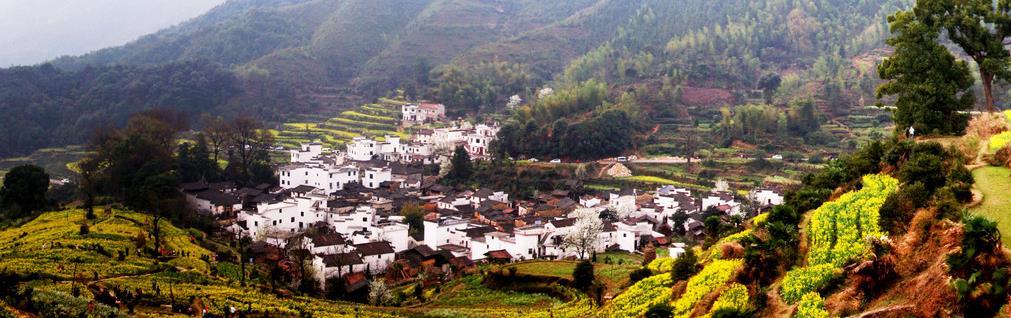
2 Terrace Distribution in China

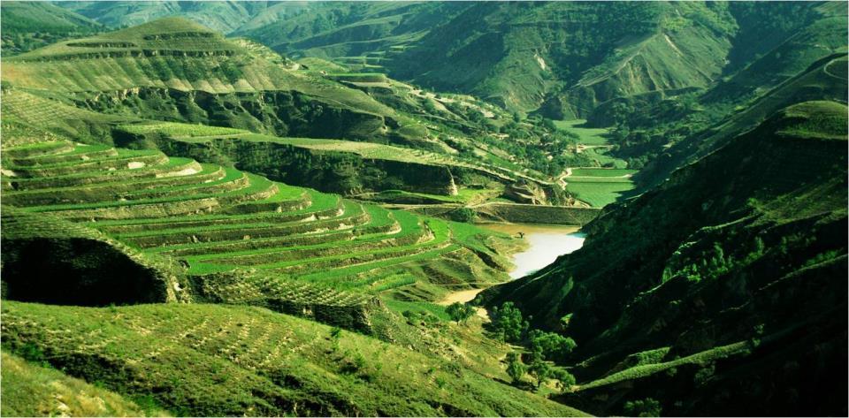
3 Terraces in Loess Plateau


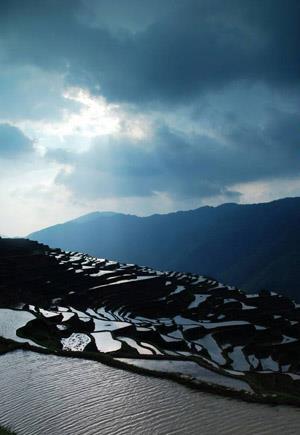
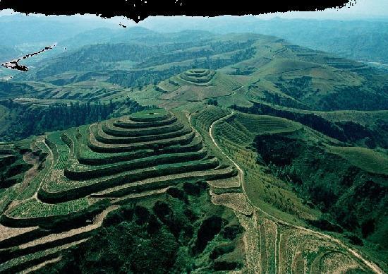
4 Terraces in Southwest China


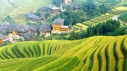
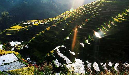
5 Terraces in Southeast Hilly Area of China

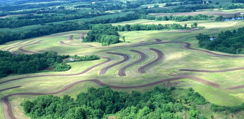
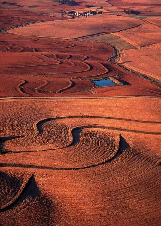
6 US Terraces

7 Sino-US Terrace Differences Terrace Barrier(Ridge) US Terrace Chinese Terrace Type Normal terrace Mainly bench terrace Original Slope Mostly Less than 10% Mainly between 5% and 46% Barrier Soil Soil or stone bank Drainage Underground pipe or grass water way Lined channel

 Watershed simulation")

: 3042-3055. Waidler, D., M.")

8 Current methods to simulate terraces in SWAT Previous studies have represented terraces by changing the value of : Runoff effect: curve number (CN2) Erosion effect: slope length and USLE control practice factor (USLE P-factor) Watershed simulation Terrace related variables References: Arabi, M., J. R. Frankenberger, B. A. Engel, and J. G. Arnold Representation of agricultural conservation practices with SWAT. Hydrological Processes 22(16): Waidler, D., M. White, E. Steglich, C. A. Jones, and R. Srinivasan Conservation Practice Modeling Guide for SWAT and APEX. TR-399. College Station, Texas: Texas A&M University System.


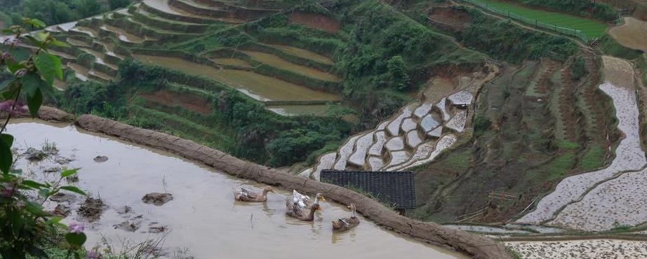
9 Terrace algorithm development Segment simulation Runoff: SCS curve number Erosion: MUSLE method Nutrients: nitrogen & phosphorous Plant growth: optimal growth & stress More: plant management, lateral flow, water harvesting etc. Map of bench terrace Map of normal terrace


10 Terrace storage effects Sub-daily simulation Sediment and nutrient settlement Extra infiltration Extra evaporation Inside terrace channel erosion Map of normal terrace Terrace output

11 SWAT Incorporation The terrace algorithms were integrated into SWAT at the HRU level by creating a sub-hru area with its own shape and soil system. Separate: soil, topography, crop management Share: ground water Sketch map of an HRU in SWAT with a terraced area Link: terrace output (drainage, overland flow)

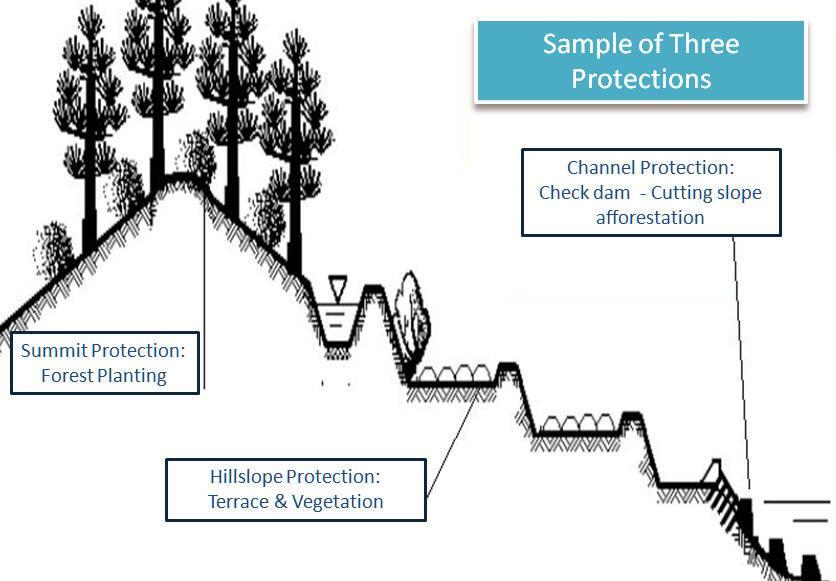
12 Flowchart of the terrace simulation algorithm The terrace algorithm code was incorporated in SWAT model version 488. The terrace simulation activation subroutine is called in the HRU loop of a terraced HRU.

13 Model testing Planar view Sectional view Runoff plot Original ground line 5 Reverse-slope terrace 1 1.2m Reverse-slope terrace 2 Runoff tank Terrace in China Terrace in the US
 in southwest China was used for calibration and validation. Yunnan Province, China Calibration Validation Runoff Ave. NS = 0.58 Ave. NS = 0.80 Calibration Validation Calibration Validation Sediment Ave.")
14 Terraced Experimental Plots in China A previously published 2 year long runoff, sediment and total nitrogen dataset collected on 2 natural rainfall runoff plots (one control plot and one terrace plot) in southwest China was used for calibration and validation. Yunnan Province, China Calibration Validation Runoff Ave. NS = 0.58 Ave. NS = 0.80 Calibration Validation Calibration Validation Sediment Ave. NS = 0.50 Ave. NS = 0.69 Ave. NS = 0.53 Ave. NS = 0.61 Total nitrogen

15 Terraced field scale plots in Kansas, US The modified SWAT model was evaluated using a 4-year long 6-plot event runoff and sediment data set with 5 years of plant yield data collected on a natural rainfall terraced field in southeast Franklin County, Kansas. Franklin, KS Calibration Validation Runoff Ave. NS = 0.77 Ave. NS = 0.71 Calibration Validation Ave. NS = 0.63 Sediment Ave. NS = 0.75 Ave. NS = 0.77 Crop Yield
16 Watershed application tool development The tool creates and modifies terrace inputs for the relevant HRU s in a watershed, and facilitates the application of the terrace model at watershed scale. Subbasin list Terrace fraction Inflow fraction Terrace input creation file(trc_fig.fig) Read parameter values from original SWAT input files Create terrace input files Write terrace related variable values

17 Watershed application Study Area 6794 km 2 Pasture / grassland: 45% Cropland 41% Forest: 14% Slopes: 2 64% Upstream of Chejiachuan station of the Weihe River Basin


18 Watershed application Problem Weihe River Basin Weihe River Weihe river is the largest branch of the Yellow River. In recent years, the runoff and water resources have decreased a lot under similar rainfall level. Why? Water conservation measures in the upstream areas? Dams on the main reaches?

19 Preliminary Results Model setup: No change of land cover in the terrace. No adjustment of CN with slope. Results: No changes in runoff, ET, and groundwater ET Groundwater recharge Water yield


20 Conclusions A process-based terrace algorithm was developed in SWAT to simulate the environmental effects of terraces, including normal terrace used in the US and bench terrace. Application results indicated successful performance of the terrace model at field and watershed scales. More applications on different types of terraces and soils will be needed for further validation and improvement of the model. Future development of a GIS tool to determine the terrace parameter values at the watershed scale will help effectively apply the model at larger spatial scales.
21
Bioretention cell schematic key
 Bioretention Cells Bioretention cell schematic key 1 3 Hardwood mulch 2 Curb cut 3 18-30 Modified soil 4 Stone aggregate choker layer 5 Stone aggregate base layer 6 Subdrain 7 Undisturbed soil 8 Overflow/Cleanout
Pollutant Removal Benefits
 Bioswales Bioswales Similar to biocells, but have a slight, but positive grade toward an outlet Designed to convey the WQv event at very low velocities Promote filtration through native vegetation, infiltration
Leduc Industrial Outline Plan SE W4
 Leduc Industrial Outline Plan SE 1-50-25-W4 Within the North Leduc Industrial ASP Prepared for: Leduc Energy Park Ltd. Prepared by: Stantec Consulting Ltd. File No. 1161 104655 V5 Table of Contents 1.0
Three Rivers Park District Administration Center Rain Garden
 Three Rivers Park District Administration Center Rain Garden Introduction There are significant changes to the hydrologic regime and nutrient loading following urban and industrial development. The post-development
Development of a web-based interface for simulating alternative conservation practices using APEX
 Development of a web-based interface for simulating alternative conservation practices using APEX ASABE Annual International Meeting, New Orleans, LA 29 July 2015 Presented by: Naresh Pai (Stone Environmental),
MANUAL OF DESIGN, INSTALLATION, AND MAINTENANCE REQUIREMENTS FOR STORMWATER MANAGEMENT PLANS
 MANUAL OF DESIGN, INSTALLATION, AND MAINTENANCE REQUIREMENTS FOR STORMWATER MANAGEMENT PLANS May 2007 SECTION 1 Responsibility of Applicant TABLE OF CONTENTS A. Stormwater Management Plan Required Information
Runoff Modelling for Simulating Inundation in Urban Area as a Result of Spatial Development Change
 2012, TextRoad Publication ISSN: 2090-4215 Journal of Applied Environmental and Biological Sciences www.textroad.com Runoff Modelling for Simulating Inundation in Urban Area as a Result of Spatial Development
Figure 1 Cypress Street Study Area Location Map
 July 20, 2016 TO: FROM: Jim Massarelli Director of Engineering Jeff Julkowski, PE Michael Burke, PE SUBJECT: Cypress Street Study Area Stormwater Analysis (CBBEL Project No. 16-0058) At the request of
TENNESSEE GAS PIPELINE COMPANY, L.L.C.
 TENNESSEE GAS PIPELINE COMPANY, L.L.C. HYDROLOGIC AND HYDRAULIC CALCULATIONS FOR ACCESS ROADS ALONG THE CONNECTICUT PIPELINE EXPANSION PROJECT CONNECTICUT LOOP Submitted by: Tennessee Gas Pipeline Company,
Investigation on Jiji Grass carried out in north China
 Investigation on Jiji Grass carried out in north China Liyu Xu 1 Deyou Hu 2 Lehong Tang 2 (1 China Vetiver Network, Nanjing 210008;2 Tianpeng Lande Grass Ecological Technology of Jiangsu Province Co.,
Impact of Storm Drains on Urbanized Alluvial Fan Flooding in Ventura County, California
 Impact of Storm Drains on Urbanized Alluvial Fan Flooding in Ventura County, California Presented to: FMA Annual 2015 Conference September 8-11, 2015 Presented by: Jim O Brien, Ph.D., P.E. Noemi Gonzalez,
Rainwater Management an issue for the 21 st Century. Hydrological Cycle
 Canadian Society of Landscape Architects CONGRESS 2014 Rainwater Management an issue for the 21 st Century Don Crockett, BCSLA, CSLA Principal, Golder Associates Ltd. May 2014 Hydrological Cycle PRE- URBAN
Conservation in South Jersey Being Creative with Restoration
 Conservation in South Jersey Being Creative with Restoration Stewardship on a Shoestring: Public Land Management in Fiscally Constrained Times November, 30, 2011 Conservation and Restoration for Open Space
The Nature of Soil Soil Conservation Sustainable Ag.
 Chapter 6 & 7 The Nature of Soil Soil Conservation Sustainable Ag. Climate Soil Forming Factors Parent material Organisms Topography Time Value of Soil Soil is under appreciated Condition of soil affects
Roof Runoff Harvesting Benefits for Regional Conditions in Low Density and Medium Density Residential Areas. Leila Talebi 1 and Robert Pitt 2
 Roof Runoff Harvesting Benefits for Regional Conditions in Low Density and Medium Density Residential Areas Leila Talebi 1 and Robert Pitt 2 1Graduate Student, Department of Civil, Construction, and Environmental
Division Study of Rainwater Utilization in China
 Division Study of Rainwater Utilization in China Haisheng Mou, Huilin Wang, Hsiang-te Kung Beijing Research and Application Institute of Water 1900 Clinton Ave. S., Apt. 11 Minneapolis, MN 55404 USA Fax:
Chapter 4 - Preparation of Stormwater Site Plans
 Chapter 4 - Preparation of Stormwater Site Plans The Stormwater Site Plan is the comprehensive report containing all of the technical information and analysis necessary for the City to evaluate a proposed
KENT COUNTY STORMWATER MAINTENANCE DISTRICT STORMWATER BMPs MAINTENANCE TASKS AND RESPONSIBILITIES GUIDANCE DOCUMENT BIO-RETENTION FACILITIES
 BIO-RETENTION FACILITIES (for all basins / BMPs) Annually Prepare Operation and Maintenance Plan. Clearly outline how vegetation in the facility and its buffer area will be managed or harvested in the
The Concept, Components and Methods of Rainwater Harvesting
 2 nd Arab Water Forum Living With Water Scarcity Cairo, November 20-23, 2011 Dieter Prinz The Concept, Components and Methods of Rainwater Harvesting Cairo, 21 Nov. 2011 Prof. Dr. Dieter Prinz, Karlsruhe,
Rainwater Harvesting: Where does the Rainfall Go?
 Rainwater Harvesting: Where does the Rainfall Go? Justin Mechell Extension Assistant Department of Biological and Agricultural Engineering Texas A&M University Objectives Understand a watershed and how
STAFFORD TRACT NORTH OF US90A 1.0 INTRODUCTION 1.1 OBJECTIVE
 1.0 INTRODUCTION 1.1 OBJECTIVE This report, prepared for submittal to TxDOT, analyzes existing and proposed detention facilities draining into the TxDOT US90A storm sewer system. The results of the detailed
 PSLS Surveyors' Conference Workshop Information Form Workshop Number: (leave blank if unknown) Hours: Workshop Title: Workshop Description: Suggested Speaker(s), affiliation/contact information 1. 2. 3.
Stormwater Low Impact Development - A Natural Solution
 Stormwater Low Impact Development - A Natural Solution Sarah U Ren Program Director The Watershed Center of Grand Traverse Bay 231-935-1514, suren@gtbay.org Our Mission: The Watershed Center advocates
Problem soils & its management. Satira Udomsri, LDD
 Problem soils & its management Satira Udomsri, LDD Kingdom of Thailand Location: Southeast Asian mainland 5 o -20 o N 97 o -105 o E Area total: land: water: Capital: 513,120 sq km 510,890 sq km 2,230 sq
When planning stormwater management facilities, the following principles shall be applied where possible.
 2.0 Principles When planning stormwater management facilities, the following principles shall be applied where possible. 2.0.1 Drainage is a regional phenomenon that does not respect the boundaries between
Hydrologic Assessment of using Low Impact Development to Mitigate the Impacts of Climate Change. Chris Jensen, AScT Master of Science Thesis
 Hydrologic Assessment of using Low Impact Development to Mitigate the Impacts of Climate Change Chris Jensen, AScT Master of Science Thesis Bowker Creek Initiative April 12, 2012 Outline 1. Future Impacts
IMPLEMENTING STORMWATER MANAGEMENT REQUIREMENTS FOR DEVELOPMENT
 IMPLEMENTING STORMWATER MANAGEMENT REQUIREMENTS FOR DEVELOPMENT 4.1 Overview Description: Requirements and standards for controlling runoff from development are critical to addressing water quantity and
Chapter 3 Site Planning and Low Impact Development
 CHAPTER 3 Site Planning and Low Impact Development Chapter 3 Site Planning and Low Impact Development 3.0 Introduction The City of Charleston requires that major residential, large commercial (>1 acre),
APPENDIX B. Hydrologic and Hydraulic Analysis
 APPENDIX B Hydrologic and Hydraulic Analysis HYDROLOGIC AND HYDRAULIC ANALYSIS PETERSBURG ROAD IMPROVEMENTS DOT&PF Project No. 67879 Prepared for: State of Alaska Department of Transportation and Public
Development and Design of Cost-Effective, Real-Time Implementable Sediment and Contaminant Release Controls
 Development and Design of Cost-Effective, Real-Time Implementable Sediment and Contaminant Release Controls Richard Warner, Ph.D. Biosystems and Agricultural Engineering Department University of Kentucky
Updates to the Ground Infiltration Module in InfoWorks ICM 8.0
 Updates to the Ground Infiltration Module in InfoWorks ICM 8.0 Introduction The release of InfoWorks ICM version 8.0 has seen a couple of additional features added to the Ground Infiltration module to
Low Impact Development in Coastal South Carolina: A Planning and Design Guide
 Low Impact Development in Coastal South Carolina: A Planning and Design Guide ACE Basin & North Inlet-Winyah Bay National Estuarine Research Reserves Network of 28 Reserves NOAA Program Research, Stewardship,
BMP Siting Tool. Step-by-Step Guide
 BMP Siting Tool Step-by-Step Guide ArcGIS 10.1 Service Pack 1 (Build 3143) Prepared by: Tetra Tech, Inc. 10306 Eaton Place, Suite 340 Fairfax, VA 22030 January 2013 Contents 1 Getting Started... 1 1.1
Old Mill Community Association Bioretention Facility
 Project Overview This project will install a bioretention facility in a community recreation area owned by the Old Mill Community Association, Inc. Drainage from the area is currently unmanaged and has
DEALING WITH STORM WATER MANAGEMENT
 December 2012 DEALING WITH STORM WATER MANAGEMENT This fact sheet provides information on the guiding principles of storm water management practices, explains the difference between structural and non-structural
ST. MARY S SOIL CONSERVATION DISTRICT (SMSCD) AND DPW&T CONCEPT EROSION AND SEDIMENT CONTROL AND STORMWATER MANAGEMENT GUIDELINES AND CHECKLIST
 AND DPW&T CONCEPT EROSION AND SEDIMENT CONTROL AND STORMWATER MANAGEMENT GUIDELINES AND CHECKLIST") St. Mary s Soil Conservation District 26737 Radio Station Way, Suite B Leonardtown, MD 20650 Phone: 301-475-8402 ext. 3 Fax: 301-475-8391 www.stmarysscd.com St. Mary s County Government Department of Public
St. Mary s Soil Conservation District 26737 Radio Station Way, Suite B Leonardtown, MD 20650 Phone: 301-475-8402 ext. 3 Fax: 301-475-8391 www.stmarysscd.com St. Mary s County Government Department of Public
Shelbyville, KY Stormwater Best Management Practices. Section 2 EROSION PREVENTION AND SEDIMENT CONTROL PLAN
 Section 2 EROSION PREVENTION AND SEDIMENT CONTROL PLAN 2.1 Requirements The City of Shelbyville, KY will require an Erosion Prevention and Sediment Control (EPSC) Plan for most types of development construction.
Methods to Simulate the Impact of BMPs
 LA221 Project Ortega Watershed Demonstration Area, Quito Ecuador Ricardo da Cruz e Sousa Master of Landscape Architecture & Environmental Planning University of California, Berkeley December 2011 Ortega
4.6. Low Impact and Retentive Grading
 4.6. Low Impact and Retentive Grading Low Impact Grading techniques focus on utilizing existing topography during Site layout to minimize cost. Proposing structures, roads, and other impervious surfaces
Evaluating Low Impact Development Practices for Stormwater Management on an Industrial Site in Mississippi
 Evaluating Low Impact Development Practices for Stormwater Management on an Industrial Site in Mississippi Dennis S. Painter, Tennessee Valley Authority, Nashville, Tennessee Donald Becker, Tennessee Valley
Predicting Design Storm Runoff for the Six Mile Creek Watershed: Effects of the Potential Sprawl-Is-Us, Inc. Development
 Predicting Design Storm Runoff for the Six Mile Creek Watershed: Effects of the Potential Sprawl-Is-Us, Inc. Development Ross Guida Faulkner Consulting Engineers, Inc. December 19, 2008 1 Table of Contents
Selecting the Right Closure Cap Option for Your Surface Impoundment or CCR Landfill
 2017 World of Coal Ash (WOCA) Conference in Lexington, KY - May 9-11, 2017 http://www.flyash.info/ Selecting the Right Closure Cap Option for Your Surface Impoundment or CCR Landfill Steven C. Lamb 1,
6.5 Lakewood Gulch. Basin Snapshot
 6.5 Lakewood Gulch The Lakewood Gulch Map Unit is comprised of both Lakewood Gulch and Dry Gulch (4800-01 and 4801-01) from the Denver Storm Drainage Master Plan (SDMP) and has a total drainage area of
North Branch of Cypress Creek Ecological Restoration: A Comprehensive Approach to Stream Restoration
 North Branch of Cypress Creek Ecological Restoration: A Comprehensive Approach to Stream Restoration Rocky Powell Clear Creeks Consulting, LLC Keith D. Tate, P.E. BayLand Consultants & Designers, Inc.
Citywide Integrated Stormwater Management Plan (ISMP) DRAFT ACTION PLAN REVIEW Public Consultation November 16 th, 2016
 DRAFT ACTION PLAN REVIEW Public Consultation November 16 th, 2016") Citywide Integrated Stormwater Management Plan (ISMP) DRAFT ACTION PLAN REVIEW Public Consultation November 16 th, 2016 1 Agenda DRAFT ACTION PLAN REVIEW Public Consultation Time 6:00 6:05 6:05 6:20 6:20
Citywide Integrated Stormwater Management Plan (ISMP) DRAFT ACTION PLAN REVIEW Public Consultation November 16 th, 2016 1 Agenda DRAFT ACTION PLAN REVIEW Public Consultation Time 6:00 6:05 6:05 6:20 6:20
Urban Stormwater Retrofit Program Highlights
 Urban Stormwater Retrofit Program Highlights Delaware Estuary Environmental Summit 2007 Prepared and Presented by: Liz Feinberg Project Funding: William Penn Foundation PA Coastal Zone Management Program
Urban Conservation Practice Physical Effects ESTABLISHMENT, GROWTH, AND HARVEST NUTRIENT MANAGEMENT
 NOT WELL 800 - Urban Stormwater Wetlands A constructed system of shallow pools that create growing conditions for wetland plants to lessen the impacts of stormwater quality and quantity in urban areas.
Rain Gardens. A Welcome Addition to Your Landscape
 Rain Gardens A Welcome Addition to Your Landscape Where Does The Rainwater Go? Naturally, forests provide a way for rainwater to percolate into the soil, filtering pollutants while trees are allowed to
STORMWATER REPORT FOR WALMART SUPERCENTER STORE # SIOUX FALLS, LINCOLN COUNTY, SOUTH DAKOTA BFA PROJECT NO
 STORMWATER REPORT FOR WALMART SUPERCENTER STORE # 2443-00 SIOUX FALLS, LINCOLN COUNTY, SOUTH DAKOTA BFA PROJECT NO. 3286 March 1, 2012 I hereby certify that this engineering document was prepared by me
The soil and water conservation effects and key issues by conservation tillage in Loess Plateau. HAO Mingde
 The soil and water conservation effects and key issues by conservation tillage in Loess Plateau HAO Mingde Institute of soil and water conservation, CAS & MWR; Institute of soil and water conservation,
University, Yangling, P. R. China b State Key Laboratory of Soil Erosion and Dryland Farming on the
 This article was downloaded by: [Northwest A & F University] On: 28 September 2014, At: 17:09 Publisher: Taylor & Francis Informa Ltd Registered in England and Wales Registered Number: 1072954 Registered
5/19/2011. Photos: David Dods, URS
 Rain Gardens Designing for the Midwest and Texas Agenda 1. Why LID? 2. Rain Garden Design for the Midwest David Dods URS Corp., Overland Park, KS 913.344.1022, david_dods@urscorp.com 3. Native vs. Engineered
DFH JOINT VENTURE. Stormwater Management Report for Proposed Residential Subdivision at Graham Block, Pokeno
 DFH JOINT VENTURE Stormwater Management Report for Proposed Residential Subdivision at Graham Block, Pokeno DOCUMENT CONTROL RECORD Document: DFH Joint Venture Graham Block Stormwater Management Report
Sustainable Stormwater Management with Low Impact Development (LID)
") Sustainable Stormwater Management with Low Impact Development (LID) Chui Ting Fong, May Department of Civil Engineering The University of Hong Kong HKIE Seminar Nov 27, 2014 1 Hydrologic Impact of Urbanization
Sustainable Stormwater Management with Low Impact Development (LID) Chui Ting Fong, May Department of Civil Engineering The University of Hong Kong HKIE Seminar Nov 27, 2014 1 Hydrologic Impact of Urbanization
4. CONCEPT PLAN DEVELOPMENT
 4. CONCEPT PLAN DEVELOPMENT Concept Plan Step 1: Identify Site Constraints and Opportunities Review the existing site to identify constraints and opportunities for GI Practices to meet the RRv. Constraints
Living on contour. The art of land shaping for natural rainfall catchment, a practical guide to water harvesting and management.
 Living on contour The art of land shaping for natural rainfall catchment, a practical guide to water harvesting and management Olmec Sinclair Deserts are dry and dead, water is the foundation of life Desert
PRELIMINARY DRAINAGE REPORT LATHAM 200 MMSCFD GAS PROCESSING PLANT
 PRELIMINARY DRAINAGE REPORT LATHAM 200 MMSCFD GAS PROCESSING PLANT LOTS B, RECORDED EXEMPTION 1211-2-1, RECX13-0096 LOCATED IN THE NORTH 1/2 OF SECTION 2, TOWNSHIP 3 NORTH, RANGE 66 WEST, 6 TH PRINCIPAL
STREAM BANK STABILIZATION THORPS MORTIMER RECREATION AREA Grandfather Ranger District SITE LOCATION & DRAINAGE AREA
 STREAM BANK STABILIZATION THORPS CREEK @ MORTIMER RECREATION AREA SITE LOCATION & DRAINAGE AREA SITE LOCATION Drainage Area = 1.14 sq. miles STREAM BANK STABILIZATION THORPS CREEK @ MORTIMER RECREATION
Modeling linkages between effective impervious surface and urban vegetation productivity in semi-arid environments
 Modeling linkages between effective impervious surface and urban vegetation productivity in semi-arid environments Catherine Shields PhD candidate, Bren School of Environmental Science and Management University
Post Construction BMPs
 Post Construction BMPs Why are Post Construction BMPs important? With increased development brings the increase of impervious cover Parking lots, rooftops, driveways Storm water runoff volume increases
APPENDIX A. Proposed Guidance and LID checklists for UConn and Town of Mansfield
 APPENDIX A. Proposed Guidance and LID checklists for UConn and Town of Mansfield 22 Guidance Document for Low Impact Development Best Management Practices for UConn June, 2011 In 2007, the Connecticut
5. LOW IMPACT DEVELOPMENT DESIGN STANDARDS
 5. LOW IMPACT DEVELOPMENT DESIGN STANDARDS Low Impact Development (LID) requires a shift in stormwater management away from conveying runoff to a small number of downstream points through hydraulically
BLACK/HARMONY/FAREWELL CREEK WATERSHED EXISTING CONDITIONS REPORT CHAPTER 5 IMPERVIOUS SURFACES
 BLACK/HARMONY/FAREWELL CREEK WATERSHED EXISTING CONDITIONS REPORT CHAPTER 5 IMPERVIOUS SURFACES Draft November 2009 TABLE OF CONTENTS 1.0 INTRODUCTION... 3 2.0 STUDY AREA AND SCOPE... 4 3.0 METHODOLOGY...
Draft Rhode Island Stormwater Design and Installation Standards Manual
 Draft Rhode Island Stormwater Design and Installation Standards Manual Summary The May 2009 Public Review Draft version of the RI Stormwater Design and Installation Standards Manual consists of approximately
Rainwater Harvesting: Soil Storage and Infiltration Systems
 Rainwater Harvesting: Soil Storage and Infiltration Systems Justin K. Mechell Texas Cooperative Extension Department of Biological and Agricultural Engineering Texas A&M University How Rainwater Harvesting
Why a new Food & Farm Ordinance?
 Growing for Kane Why a new Food & Farm Ordinance? 1. Growing obesity issue 64% of Kane adults are overweight or obese 2. Low rates of fruit & vegetable consumption Healthy diets include more fruits & veggies.
Introduction to Environmental Science. Soil Characteristics. Chapter 11 Soil
 Chapter 11 Soil Soil Characteristics It s more than dirt Most soils are 100s of years old Weathering breaks down parent rock Soil Separates (particle types) Sand (largest) Silt Clay (smallest) Plants contribute
Case Study: Dallas Green Infrastructure for Stormwater
 Case Study: Dallas Green Infrastructure for Stormwater Extension and Research Sandhya Mohan Fouad H. Jaber, PhD Biological and Agricultural Engineering Texas Agrilife, Texas A&M University System Urban
Lincoln 270. City of Lincoln. Stormwater Management Plan. April 2, 2013
 Lincoln 270 City of Lincoln Stormwater Management Plan April 2, 2013 # 2005.48 Prepared By: Civil Engineering Solutions, Inc. 590 E Street Lincoln, Ca 95648 (916) 645 5700 1.0 Background: The project site
The Prospects of Rainwater Utilization in the Taihang Mountain, China
 The Prospects of Rainwater Utilization in the Taihang Mountain, China Zhang Wanjun, Liu Zhijun, Cao Jiansheng (Shijiazhuang Institute of Agricultural Modernization, CAS, 050021, China) Abstract Based on
STORMWATER SITE PLAN INSTRUCTIONS AND SUBMITTAL TEMPLATE Medium and Large Projects
 DEPARTMENT OF COMMUNITY DEVELOPMENT 621 Sheridan Street, Port Townsend, WA 98368 Tel: 360.379.4450 Fax: 360.379.4451 Web: www.co.jefferson.wa.us/communitydevelopment E-mail: dcd@co.jefferson.wa.us STORMWATER
Appendix D - Technical Design Criteria for BMPs
 Appendix D - Technical Design Criteria for BMPs City of Wayzata Page 3 On-site infiltration features Definitions and Scope: Infiltration facilities are constructed basins or depressions located in permeable
Modeling Cumulative LID Features for Floodplain Impacts in an Urban Watershed in Houston, TX
 Modeling Cumulative LID Features for Floodplain Impacts in an Urban Watershed in Houston, TX Christina Hughes, Phil Bedient cmhughes@rice.edu May 2, 2014 1 Modeling Cumulative LID Features for Floodplain
Using LID Projects for Sustainable Development: A Case Study from the Chain of Lakes City
 Using LID Projects for Sustainable Development: A Case Study from the Chain of Lakes City When we try to pick out anything by itself, we find it hitched to everything else in the universe. John Muir M.J.
Urban Stormwater Management
 State Regulations and Sustainable Infrastructure April 16, 2011 Urban Stormwater Management Drivers Ecosystem Services LID and Light Imprint New Urbanism Comments MD Stormwater Regulations Larry S. Coffman
Study on the Influence of Urban River Topology on Landscape Design
 2017 3rd International Conference on Social Science, Management and Economics (SSME 2017) ISBN: 978-1-60595-462-2 Study on the Influence of Urban River Topology on Landscape Design Tao Zhang 1 Abstract
APPENDIX E DESIGN CRITERIA FOR POST-CONSTRUCTION WATER QUALITY BMPS
 APPENDIX E DESIGN CRITERIA FOR POST-CONSTRUCTION WATER QUALITY BMPS This Appendix presents design criteria for Post-Construction Water Quality BMPs to meet 80% TSS removal for use on SCDOT projects: Section
INTERLINKING URBAN DEVELOPMENT AND URBAN DRAINAGE? AN ACTION MANUAL
 INTERLINKING URBAN DEVELOPMENT AND URBAN DRAINAGE? AN ACTION MANUAL Lisa Deister Institute of Landscape Planning and Ecology, University of Stuttgart Malte Henrichs Institute for Water Resources Environment,
Optimizing Denitrification in Agricultural Streams. Todd V. Royer & Jennifer L. Tank
 Optimizing Denitrification in Agricultural Streams Todd V. Royer & Jennifer L. Tank Goals Lay a general groundwork for a discussion of how to optimize denitrification in agricultural landscapes Suggest
Sushil Ade1,Harshal Pathak2, Pravin Chaudhari3
 International Journal of Modern Trends in Engineering and Research www.ijmter.com e-issn No.:2349-9745, Date: 28-3 April, 26 Best Management Practices (BMP s) Used for Flood MitigationOn Mitthi River Sushil
Brian Friedlich, PE. Jeremiah Bergstrom, LLA
 Engineering Concepts for Bioretention Facilities: From Rain Gardens to Basins NJASLA 2011 Annual Meeting & Expo February 1, 2011 Brian Friedlich, PE Senior Engineer Jeremiah Bergstrom, LLA Senior Project
INTRODUCTION TO GREEN INFRASTRUCTURE HOW WE CAN PROTECT OUR COMMUNITIES AND OUR WATERS Maywood Public Library Bergen County, New Jersey
 INTRODUCTION TO GREEN INFRASTRUCTURE HOW WE CAN PROTECT OUR COMMUNITIES AND OUR WATERS Maywood Public Library Bergen County, New Jersey Jeremiah D. Bergstrom, LLA, ASLA Rutgers Cooperative Extension Water
DEVELOPMENT OF A SWAT-BASED SOIL PRODUCTIVITY INDEX
 DEVELOPMENT OF A SWAT-BASED SOIL PRODUCTIVITY INDEX Roberto de J. López-Escudero 1 Jesus Uresti-Gil 1 Héctor D. Inurreta-Aguirre 1 Diana Uresti-Durán 1 1 Instituto Nacional de Investigaciones Forestales,
Green Innovation Grant Program
 Green Innovation Grant Program Southeast New York Stormwater Conference Beacon, NY October 15, 2014 What is Green Infrastructure? Green stormwater infrastructure includes a wide array of practices at multiple
WQ-23 MOUNTAINOUS AND STEEP SLOPE SITES
 Greenville County Technical Specification for: WQ-23 MOUNTAINOUS AND STEEP SLOPE SITES 1.0 Mountainous and Steep Slope Sites 1.1 Description The geographic locations of portions of Greenville County are
Impervious Cover Reduction Action Plan for City of Vineland, Cumberland County, New Jersey
 Impervious Cover Reduction Action Plan for City of Vineland, Cumberland County, New Jersey Prepared for the City of Vineland by the Rutgers Cooperative Extension Water Resources Program May 23, 2016 Table
Figure 1. Bioswale along roadside. Photo courtesy of CalTrans. Figure 2. Diagram of typical bioswale (adapted from UDFCD 1999)
") Design Manual: Biological Filtration Canal (Bioswale) Dayna Yocum, Bren School of Environmental Science and Management, University of California, Santa Barbara Figure 1. Bioswale along roadside. Photo
Design Manual: Biological Filtration Canal (Bioswale) Dayna Yocum, Bren School of Environmental Science and Management, University of California, Santa Barbara Figure 1. Bioswale along roadside. Photo
2E-4 Bioretention Cells
 Iowa Stormwater Management Manual 2E-4 2E-4 Bioretention Cells BENEFITS Low =
Appendix I. Checklists
 Appendix I Checklists Town of Greenwich Drainage Manual Department of Public Works - Engineering Division Town Hall - 101 Field Point Road, Greenwich, CT 06836-2540 Phone 203-622-7767 - Fax 203-622-7747
Green Roofs and Stormwater Management Virginia Stovin
 Green Roofs and Stormwater Management Virginia Stovin Department of Civil and Structural Engineering Pennine Water Group University of Sheffield Outline Urban stormwater management Conventional solutions,
4.0 EROSION AND SEDIMENT PROCESS. 4.1 Mechanics of Erosion
 4.0 EROSION AND SEDIMENT PROCESS 4.1 Mechanics of Erosion SECTION 4 - EROSION AND SEDIMENT PROCESS Erosion is the wearing away of material by naturally occurring agents through the detachment and transport
CHAPTER 4. SPECIAL CONDITION EROSION CONTROL MEASURES
 CHAPTER 4. SPECIAL CONDITION EROSION CONTROL MEASURES 4.1 INFILTRATION BASIN AND TRENCH Figure 4.1. Infiltration basin and trench (Source: Department of Civil, Construction, and Environmental Engineering,
 Stormwater Management Plan Narrative Quality Fleet Services, Inc. SITE RE-DEVELOPMENT 548 New Ludlow Road South Hadley, MA The project proposed by Quality Fleet Services, Inc. consists of the site improvements
Appendix 6-A. Site Plan Preparation and Submission as Part of the Land Development Process
 Appendix 6-A Site Plan Preparation and Submission as Part of the Land Development Process Table of Contents Appendix Section Headings 6-A.1.0 INTRODUCTION 6-A-2 6-A.2.0 THE STORMWATER MANAGEMENT PLAN 6-A-6
Charles County, MD Low Impact Development (LID)/ Environmental Site Design (ESD) Ordinance & Design Manual
/ Environmental Site Design (ESD) Ordinance & Design Manual") Charles County, MD Low Impact Development (LID)/ Environmental Site Design (ESD) Ordinance & Design Manual Presentation Highlights Background What is LID / ESD? Why adopt LID/ESD MD SWM Act 2007 Planning
Charles County, MD Low Impact Development (LID)/ Environmental Site Design (ESD) Ordinance & Design Manual Presentation Highlights Background What is LID / ESD? Why adopt LID/ESD MD SWM Act 2007 Planning
Town of Hague Stormwater Outfall Evaluation Report
 Town of Hague Stormwater Outfall Evaluation Report Prepared by the Warren County Soil and Water Conservation District For the Town of Hague and the Lake George Park Commission November 2012 Table of Contents
LID Measures for Water Supply Source Protection: the Case of Quebec City and St-Charles Lake
 6 th Annual TRIECA Conference March 22 & 23, 2017 LID Measures for Water Supply Source Protection: the Case of Quebec City and St-Charles Lake Gilles Rivard, ing. M. Sc. Vice-President Urban Hydrology
Green Infrastructure and the Urban Forest: Thinking Outside the Planter Box
 Green Infrastructure and the Urban Forest: Thinking Outside the Planter Box James DeRoussel RLA P r o g r a m M a n a g e r W a t e r s h e d M a n a g e m e n t G r o u p Let s put a tree there! What
CHAPTER 3 REGULATED LAND-DISTURBING ACTIVITIES AND APPLICABLE REQUIREMENTS
 CHAPTER 3 REGULATED LAND-DISTURBING ACTIVITIES AND APPLICABLE REQUIREMENTS 3.1 INTRODUCTION As discussed in Chapter 1, development in Henrico County is subject to numerous environmental programs required
City of Stoughton Erosion Control Permit Application (effective 2/6/2018)
") City of Stoughton Erosion Control Permit Application (effective 2/6/2018) Incomplete applications will not be accepted Project Name: Address of subject property: Landowner Name(s): Applicant Name: Landowner
City of Stoughton Erosion Control Permit Application (effective 2/6/2018) Incomplete applications will not be accepted Project Name: Address of subject property: Landowner Name(s): Applicant Name: Landowner