Tracking spatiotemporal patterns of building vulnerabilities and evacuations during flood hazards
|
|
|
- Deirdre McDowell
- 5 years ago
- Views:
Transcription


1 Tracking spatiotemporal patterns of building vulnerabilities and evacuations during flood hazards Shane Hubbard Junchuan Fan Kathleen Stewart Emily White The University of Wisconsin Madison, SSEC/CIMSS August 6 th, 2014
 contents in the $100Ms Classes cancelled and major research programs were delayed or even lost Arts")
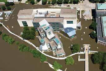
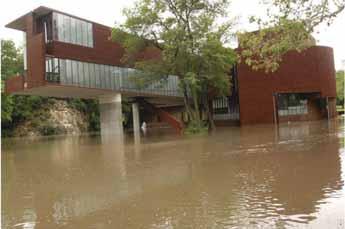
2 Background June 2008, Iowa City Record flood by 3 feet (1993) 25 buildings damaged on the UIowa Campus Flood damage and rebuilding costs $743M $1B (2011 Globe Gazette) contents in the $100Ms Classes cancelled and major research programs were delayed or even lost Arts Campus
3

4 A Unique Evacuation
5 Open Research Questions Approached by University group responsible for flood planning and response. What are the factors that affect campus evacuations? Critical infrastructure? Research? Student Housing? How to design a model that can be used to support decision-making about building evacuations on campus? What are the underlying spatiotemporal properties of a model for campus building evacuations?
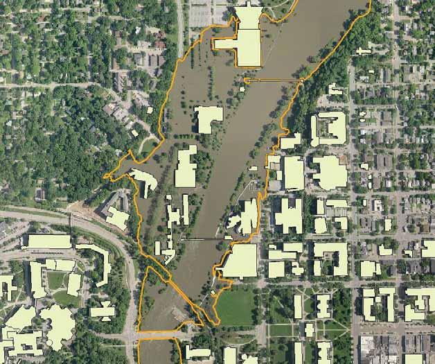
6 A foundation for evacuation planning The model will provide a means to analyze and visualize a time-varying flood boundary and how it intersects with different parts of the campus show which parts of the campus are vulnerable to flooding as the flood boundary changes over time form the basis for prioritizing evacuations on the UI campus based on information about the spatiotemporal properties of the flood boundary combined with data about building location, contents and access
 flood stage along the University")
 Flood depth grids continue every 0.")
7 Data collection: flood boundary data Obtained a set of flood depth grids for the Iowa River from The Iowa Flood Center Our model begins with flood depth grids that equate a 17-foot (7,180 cfs) flood stage along the University of Iowa campus The National Weather Service (NWS) reports the University of Iowa Campus sees building damage at approx 27 feet (25,100 cfs) Flood depth grids continue every 0.5 feet of flood stage from 17 through 34 feet (55,000 cfs)
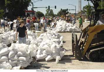
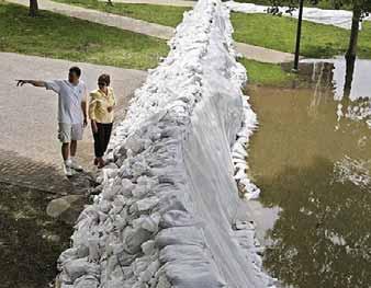
8 Automation The process of creating flood layers and formatting each into a GIS layer viewable on a webpage. Automation allows real-time depth grid development on the fly Coffer dam Sandbagging efforts

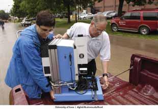
9 Data collection: spatial data Acquired spatial data from Facilities Management Updated GIS data of all campus roads, buildings and residence halls, sidewalks, parking lots, and steam tunnels as provided by Facilities Management Statewide LiDAR data Elevation data for campus terrain, campus buildings, river Campus-wide orthophotos collected June 15 th, 2008 for validation
10 University of Iowa FERP The University of Iowa has a detailed FERP that has been updated to July 2009 and more recently in 2012 Details critical buildings building watch list Evacuation plans The FERP identifies 30 buildings as at-risk facilities potentially within the flooding boundary As part of our research, we have revealed a further seven facilities also inside the flood boundary

11 Watch list buildings Art Building West Iowa Advanced Technology Lab (IATL) Mayflower Softball Complex Equipment Building Theatre Building Voxman Music Building Hancher Auditorium* English-Philosophy Bldg Adler Journalism Becker Communications Studies Bldg Library Water Plant Power Plant Cambus Maintenance Facility C. Maxwell Stanley Hydraulics Lab Art Building Museum of Art Butler Storage and Hydraulics Annexes Hydraulics Lab Model Annex Hydraulics Research East Annex Hydraulics Wind Tunnel Annex North Hall Iowa Memorial Union Danforth Chapel Madison Street Services Building Fleet Service Building Hawkeye Court Apartments Lindquist Center

12 Additional buildings at possible risk Liberty Square P. Sue Beckwith, M.D. Boathouse Campus Recreation and Wellness Center South Capitol Services Building Morgan Sanitary Eng Lab Gilbert Street Building Mossman Business Services Building
13 Building the evacuation model Two step process: A spatiotemporal analysis between flood boundaries and depth grids with University of Iowa infrastructure have been computed to determine campus areas at risk for flooding i.e., the buildings, roads, parking lots, etc. Based on these intersections and building elevations, we can determine what features are vulnerable with each new change in flood stage Time is being incorporated in the model so each flood stage and associated depth grid is associated with a likely time of building inundation. Evacuation start time = Time of risk** Time needed to evacuate building contents
14 Building Risk Layers Flood depth grids were translated into flood elevations Flooded buildings were identified for each flood elevation and placed into categories Vulnerable basement (0.5 ft grid before flooded basement) Flooded basement (revised with 2008 Flood data) Vulnerable first floor (0.5 ft grid before flooded basement) Flooded first floor (flood elevation and first floor elevation) Vulnerabilities are calculated to account for uncertainty
15 Data collection and preparation Basement flooding analysis Using data from the FERP, fields for the elevations of basements, and sub-basements of buildings on the watch-list were added to the GIS layer of university buildings For buildings with multiple basement elevations, there is a record for each of the basement elevations The estimated water table depth, the level of water in the basement, and the distance from the building to the nearest flooded area, were recorded for each flood depth But during validation found this did not produce accurate results Used the data collected from interviews on when the basements flooded and what the corresponding flood elevation was at the time.
16 Data collection and preparation First-floor flooding analysis Data from the FERP provided first-floor building elevations. The building data layer was intersected with the flood depth elevation rasters. When such an intersection exists, the flood elevation depth is compared to the first floor elevation for the building If the first floor elevation is less than the flood elevation, the first floor is considered flooded A zonal statistic is used to calculate minimum, maximum and mean water levels on the first floor. Max was used.


17 Building Risk Layers Building risk is tied to a specific flood level. In real-time risk layers are displayed based on the current and forecasted flood level

18 Risk Analysis Results Two peaks 50 Year 100 Year Related to floodplain construction regulations
19 Hazus-MH Depth/Damage Analysis The possible damage severity to each building was tracked using the average flood depth from a zonal statistics analysis in ArcGIS and then assigned a damage% from the damage curves in Hazus- MH. There are major differences in the damage functions and the default value does not reflect the historical depth damage relationship on the campus.

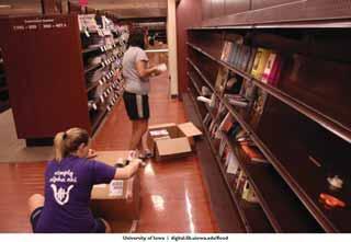
20 Building content information The direct flood risk to the building is not the entire problem. During the summer, we interviewed representatives from each of the 30+ buildings on the watch-list We collected data on estimated time needed for evacuation today time needed for evacuation during 2008 flooding details on where contents need to be moved challenges encountered during 2008 flooding length of time building was closed due to flooding key contents that would need to be evacuated details on numbers of building residents, vehicles, etc.
21 Diversity of vulnerable buildings The vulnerable buildings represent a very diverse set of needs and times for evacuation For example The University Library Mossman Business Services Building (campus mail ) UIHC Patient Transportation Services South Gilbert Street Building (Hawkshop, bookstore storage) Lindquist Center UITV, ITS Power Plant, Water Plant, IMU
22 Interview Findings Certain research projects can be extremely sensitive to evacuations Million dollar projects cannot be moved overnight Residence Halls are difficult to evacuate If summer, key faculty or administrators who would normally lead an evacuation may be away (what do we take?) Time available for evacuation is important 2 days? 5 days? What is the maximum time available for evacuations?

23 Road and Bridge Closures An important variable for modeling building evacuations is road/bridge closure or access to a building. Evacuations are road closure dependent Road and bridge closures are computed for each flood elevation Produces 2 additional evacuations.
24 Evacuation Time The recommended time evacuate is calculated by The time estimated to evacuate the building (determined by building interviews) The expected time of arrival of flooding or the loss of building access from inundated roads or closed bridges. Subtract the necessary time to evacuate the building from the expected time of arrival of flooding Conservative estimate expected time of arrival of flooding is based upon the vulnerable basement inundation time.
25 Evacuation Layers

26 Restoration Time and Priority An important consideration for evacuation priority is the length of time required to make the building functional again. Zonal statistics were used in ArcGIS to calculate the average flood depth. The Hazus-MH restoration functions were modified to estimate the time for building restoration University administrators may elect to change the evacuation recommendation time basedupon the level of importance of the building vs the time to restoration

27 Spatiotemporal Evacuation Model We have developed a real-time, visual, interactive model that uses a map-based interface to allow users to interact and query the spatiotemporal characteristics of a flood event and plan for possible evacuations Google Maps API to present the model in a web-based platform. Connected to a SQL database for data storage.


28 Putting everything together Interactive model is based on Our modeled assessments of infrastructure at risk Building content information n and FERP data Time needed for evacuations Current stream conditions and forecasts from the NWS (or other sources)

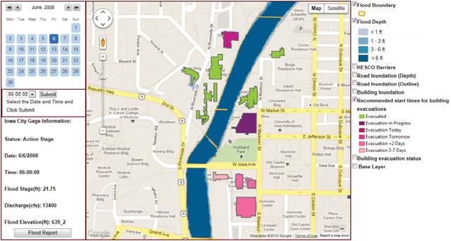
29 HawkEvac Historical, Realtime and Forecasted data Detailed Flood information Layer Selection

30 Reporting Future evacuations based on time to evacuate time of flooding 6 groups of evacuations Evacuated Evacuations in Progress Evacuations Beginning Today Evacuations Beginning Tomorrow Evacuations Beginning in 2 days Evacuations Beginning in 3 7 days Information on basements and first floors are included

31 2008 Iowa City Flood Results There is a spatiotemporal progression of flood evacuation start times across the University of Iowa campus. Not related to any flood surge movement downstream. Essential in understanding this pattern during real-time evacuations for congestion around evacuated buildings. Differences for every flood.

32 User Interaction Flood officials at the University requested a means for identifying what actually happens versus what we suggest should happen. Form was designed to provide the user with designating the current evacuation status for each vulnerable building Flash flooding University decision An additional layer is also present in the application.

33 Temporary Mitigation on Campus Future floods on campus will be mitigated with the use of HESCO barriers. The Iowa Flood Center used a HESCO layer to simulate the changes to the floodplain as a result of the mitigation measures. At this time evacuation recommendations are only calculated on the NO mitigation layers.
34 .And model validation
35 Future Work Extend model to capture recovery times The depth of water predicted inside the building. Important for faculty, staff, and students. Enhanced evacuation times based on Floor area that will be evacuated. What is being evacuated. Distance the contents must travel. Basement flooding
 263-3712 Cell: (608) 215-6059 e-mail: shane.hubbard@ssec.wisc.edu")
36 Thank You Shane Hubbard, Ph.D. Space Science and Engineering Center University of Wisconsin - Madison 1225 W. Dayton St. Madison, WI Office: (608) Cell: (608) shane.hubbard@ssec.wisc.edu
City of Norfolk Coastal Flood Mitigation Program. March 13, 2013
 City of Norfolk Coastal Flood Mitigation Program March 13, 2013 Topics Brief overview of Norfolk s Coastal Flood Program Data-driven analysis and decision making City-wide vulnerability, project concepts,
Risk Analysis Tools to Support Resilient Design
 Risk Analysis Tools to Support Resilient Design 1755 Cape Ann 6.3: BC WO Paul A. Morey FEMA Region I Woods Hole, MA/NOAA Hurricane & Earthquake Program Manager Maps Commonly used by FEMA and other Federal,
ROSS Appendix F Land Conversion. Ecosystem Services Value Lost from Land Conversion in the Central Puget Sound Region ( )
") Ecosystem Services Value Lost from Land Conversion in the Central Puget Sound Region (1992-2011) 1 Purpose The purpose of this study is to estimate, in dollars, the value of annual ecosystem services in
Ecosystem Services Value Lost from Land Conversion in the Central Puget Sound Region (1992-2011) 1 Purpose The purpose of this study is to estimate, in dollars, the value of annual ecosystem services in
Campus Planning and Capital Project Update. November 2017
 Campus Planning and Capital Project Update November 2017 Campus Planning Updates Process Updates Master Planning Progress Space Planning Major Studies Real Estate Issues City Updates Process Updates Program
GIS-Enabled Rain Garden Design: A Case Study in Austin, Texas. GIS in Water Resources (C E 394K-3) Clint Smith, E.I.T.
 Clint Smith, E.I.T.") GIS-Enabled Rain Garden Design: A Case Study in Austin, Texas GIS in Water Resources (C E 394K-3), E.I.T., MSCE 12/07/2018 Table of Contents: 1. Abstract 3 2. Introduction 4 2.1 Background 4 2.2 Project
GIS-Enabled Rain Garden Design: A Case Study in Austin, Texas GIS in Water Resources (C E 394K-3), E.I.T., MSCE 12/07/2018 Table of Contents: 1. Abstract 3 2. Introduction 4 2.1 Background 4 2.2 Project
Hazard Mitigation Planning. Association of New Jersey Environmental Commissions Workshop Edison, New Jersey October 20, 2012
 Hazard Mitigation Planning Association of New Jersey Environmental Commissions Workshop Edison, New Jersey October 20, 2012 Mitigation Planning NJ Hazard Mitigation Plan? What is the status of the HMP
Toward a Robust Flood Emergency Evacuation Integration of 2-D Hydraulic Modeling and Dynamic Evacuation Routing
 Toward a Robust Flood Emergency Evacuation Integration of 2-D Hydraulic Modeling and Dynamic Evacuation Routing Esri User Conference 2016 Sheng Tan, GISP June 29, 2016 Presentation Overview Study purpose
CITY COUNCIL AGENDA REPORT
 CITY COUNCIL AGENDA REPORT Subject: DESIGNATED FLOOD LINE CARROT CREEK Recommendation(s) That Administration bring forward a Land Use Bylaw amendment in October 2014 establishing the Designated Flood Line
Planning and Operational Applications of TRANSIMS
 Planning and Operational Applications of TRANSIMS Brian Wolshon, Ph.D., P.E. Louisiana State University Gulf Coast Center for Evacuation and Transportation Resiliency 2011 DOTD Congestion Management Seminar
Functional Areas of Practice AICP EXAM REVIEW. February 20, 2009 Georgia Tech Student Center
 Functional Areas of Practice AICP EXAM REVIEW February 20, 2009 Georgia Tech Student Center Areas of Practice Community development Comprehensive or long range planning Development regulation or administration
Creating 3D Interior Maps for Campus Planning
 Creating 3D Interior Maps for Campus Planning ESRI User Conference 2016 Parvaneh Kossari Harvard Planning & Project Management Antje Kunze SMARTERBETTERCITIES Harvard Planning & Project Management Harvard
Using FDS Modelling to Establish Performance Criteria for Water Mist Systems on Very Large Fires in Tunnels
 Using FDS Modelling to Establish Performance Criteria for Water Mist Systems on Very Large Fires in Tunnels Jack R. Mawhinney, P. Eng., FSFPE Javier J. Trelles, Ph.D. Authors & acknowledgement J. R. Mawhinney
DeltaV Analyze. Introduction. Benefits. Continuous automated DeltaV System alarm system performance monitoring
 DeltaV Distributed Control System Product Data Sheet December 2016 DeltaV Analyze Continuous automated DeltaV System alarm system performance monitoring Trends of alarms, events, and user actions Identification
The Language of Geography. Health and Human Services
 The Language of Geography Health and Human Services Cover Points of Distribution: this Esri map shows population density in relation to vaccine distribution centers, helping health officials perform a
The Esri Public Works Platform. More Than Mapping
 The Esri Public Works Platform More Than Mapping Intelligent Public Works Sustaining a safe, vibrant community requires a smart public works system. Esri created a platform that connects public works departments
Impact of Storm Drains on Urbanized Alluvial Fan Flooding in Ventura County, California
 Impact of Storm Drains on Urbanized Alluvial Fan Flooding in Ventura County, California Presented to: FMA Annual 2015 Conference September 8-11, 2015 Presented by: Jim O Brien, Ph.D., P.E. Noemi Gonzalez,
Update on University Avenue Study. September 21, 2015
 Update on University Avenue Study September 21, 2015 Existing Building Capacity Analysis Desired Potential Programs for Corridor District University Commons 50,000 +/- GSF Consolidate Student Services
Landscape Architecture (LARC)
") Landscape Architecture (LARC) 1 Landscape Architecture (LARC) Courses LARC 0841. Sustainable Design. 3 Credit Hours. What's the big deal about global warming and how should we respond to it? Explore the
Landscape Architecture (LARC) 1 Landscape Architecture (LARC) Courses LARC 0841. Sustainable Design. 3 Credit Hours. What's the big deal about global warming and how should we respond to it? Explore the
Mitigation Action Plan City of Mebane
 Mitigation Action Plan The Mitigation Action Plan for the is divided into two subsections: 7.1 Status of Previously Adopted Mitigation Actions 7.2 New 2015 Mitigation Actions 7.1 Status of Previously Adopted
242 neighborhoods NEIGHBORHOOD 4: JORDAN AVENUE CORRIDOR
 NEIGHBORHOOD 4: JORDAN AVENUE CORRIDOR Aerial View of Jordan Avenue Corridor EXISTING CHARACTER The Jordan Avenue Corridor is the portion of North Jordan Avenue that extends north from East Third Street
How to Use Fire Risk Assessment Tools to Evaluate Performance Based Designs
 How to Use Fire Risk Assessment Tools to Evaluate Performance Based Designs 1 ABSTRACT Noureddine Benichou and Ahmed H. Kashef * Institute for Research in Construction National Research Council of Canada
Planning for Historic/Cultural Resources Coastal Resiliency in Connecticut. Presented to CAFM s 3 rd Annual Conference
 Planning for Historic/Cultural Resources Coastal Resiliency in Connecticut Presented to CAFM s 3 rd Annual Conference October 25, 2016 Agenda Introduction and Project Overview Background Historic and Cultural
Sea Level Rise in the City of Vancouver: Mapping Coastal Flood Risk. Sarah North, GISP Northwest Hydraulic Consultants Ltd.
 Sea Level Rise in the City of Vancouver: Mapping Coastal Flood Risk Sarah North, GISP Northwest Hydraulic Consultants Ltd. INNER HARBOUR PORT, CONVENTION CENTRE SKYTRAIN, WEST COAST EXPRESS, FREIGHT
Village of Forest Park. July 27, Sewer Separation Evaluation
 Village of Forest Park July 27, 2015 Sewer Separation Evaluation Presentation Overview Study Background Historic Nature of Forest Park Drainage Scale of Flooding Problem Forest Park Sewer System Background
NAI Principles In Gwinnett County
 NAI Principles In Gwinnett County By Cornelius Ani, LSIT, CFM Contributors: Adena Fullard, P.E., CPSWQ Rudresh Bihalli, P.E., CFM Ken Kagy, P.E., CPESC, CPSWQ Ligia Negru, M. Sc., CFM Maja Radovic, CPESC,
Evaluation of How O&M Costs Vary for Alternative Flood Control Strategies
 Evaluation of How O&M Costs Vary for Alternative Flood Control Strategies Fargo-Moorhead Diversion Channel ASFPM Conference June 13, 2013 Matt Redington, PE Jeremy Cook HDR Engineering Red River of the
planning toronto s downtown Parks and Public Realm Plan Request for Proposals Information Meeting Andrew Farncombe, Project Manager August 19, 2015
 planning toronto s downtown Parks and Public Realm Plan Request for Proposals Information Meeting Andrew Farncombe, Project Manager August 19, 2015 BATHURST ST Keeping Downtown a great place to live, work,
Bernardo Aliaga. Ken Gledhill. Laura Kong. Programme Specialist Tsunami Unit UNESCO/IOC ICG/CARIBE EWS Technical Secretary
 UNESCO IOC CTIC US NOAA ITIC Regional Training Workshop on Strengthening Tsunami Warning and Emergency Response Standard Operating Procedures and the Development of the ICG/CARIBE-EWS PTWC New Enhanced
Mapping and the 2013 Colorado Floods. Mapping before, during, and after
 Mapping and the 2013 Colorado Floods Mapping before, during, and after Presented by Outline 2013 Floods Floodplain Mapping Before During After 20 counties 21,000 households 6000 sq. mi. 2,132 NFIP claims
TEXAS TECH UNIVERSITY HEALTH SCIENCES CENTER EL PASO
 TEXAS TECH UNIVERSITY HEALTH SCIENCES CENTER EL PASO Operating Policy and Procedure HSCEP OP: PURPOSE: REVIEW: 75.22, Flood Emergency Response Policy The purpose of this Texas Tech University Health Sciences
Winston-Salem State University Campus Master Plan 2016 Update
 Winston-Salem State University Campus Master Plan 2016 Update Request for Qualifications Page 1 of 6 Overview Winston-Salem State University (WSSU) is requesting qualifications from planning firms specializing
Live, Work, Locate and Site Selector
 Configuring Live, Work, Locate and Site Selector in Your Community John Hauck ArcGIS for State Government Solutions for Esri s government customers Series of useful maps and apps focused on government
District Facilities Master Plan
 W o r k s h o p B o a r d District Facilities Master Plan February 29, 2012 BACKGROUND + CONTEXT ANALYSIS OPTIONS RECOMMENDATIONS NEXT STEPS DFMP AGENDA BACKGROUND + CONTEXT ANALYSIS OPTIONS RECOMMENDATIONS
Using AutoCAD Civil 3D and ESRI ArcGIS to meet LEED-ND (Neighborhood Development) Requirements NDIA O Brien & Gere. All Rights Reserved.
 Requirements NDIA O Brien & Gere. All Rights Reserved.") Using AutoCAD Civil 3D and ESRI ArcGIS to meet LEED-ND (Neighborhood Development) Requirements NDIA 12457 1 Using AutoCAD Civil 3D and ESRI ArcGIS to meet LEED-ND (Neighborhood Development) Requirements
Using AutoCAD Civil 3D and ESRI ArcGIS to meet LEED-ND (Neighborhood Development) Requirements NDIA 12457 1 Using AutoCAD Civil 3D and ESRI ArcGIS to meet LEED-ND (Neighborhood Development) Requirements
Fairfax County Community Services Board Emergency Response System: Notifier
 Lathan S. Dennis, MSc., GIS Analyst Fairfax County, Human Services 12011 Government Center Parkway, Suite 946, Fairfax, VA 22035 Voice (703) 324-5648 Fax (703) 324-7572 Email ldenni@fairfaxcounty.gov Jim
Green Infrastructure Planning for Sustainability and Resiliency
 Green Infrastructure Planning for Sustainability and Resiliency Linking Lands and Communities in the Land-of-Sky Region SAMAB Conference - November 18, 2010 www.linkinglands.org Linda Giltz, AICP, Regional
Virginia Pilot. Climate Change Vulnerability and Risk Assessments of Transportation Infrastructure Hampton Roads, Virginia Implementation Pilot
 Virginia Pilot Climate Change Vulnerability and Risk Assessments of Transportation Infrastructure Hampton Roads, Virginia Implementation Pilot Yao-Jan Wu Andres Clarens Tanveer Hayat Brian Smith Jose Gomez
ArcGIS Online at Philadelphia Water Department
 ArcGIS Online at Philadelphia Water Department ESRI Public Sector Conference December 2017 Jessica Gould, GISP Megan Clarkin, AICP, LEED Green Associate Tim Smith We provide the City with integrated water,
Carleton University. Nicol Building New Sprott School of Business. Design Brief and Planning Rationale. Carleton University
 Carleton University Nicol Building New Sprott School of Business Design Brief and Planning Rationale Carleton University Design Team Proposal New Sprott School of Business Academic Building 2019 October
Sustainable Storm Water Management
 Incorporating Water Management into the Community Planning Process August 16, 2012 Sustainable Storm Water Management Samantha Brown Environmental Engineer SD1 SD1 s Service Area CVG Airport SD1 Service
Poisoned Park? How Exide s Lead Contamination Risks Frisco s Grand Park
 Frisco City Hall has big plans to transform Stewart Creek into a Grand Park with lots of water features for kids to play in. Poisoned Park? How Exide s Lead Contamination Risks Frisco s Grand Park But
Value Engineering Seminar & Design for the Woodroffe Avenue Pedestrian Bridge November 24, 2009
 Value Engineering Seminar & Design for the Woodroffe Avenue Pedestrian Bridge November 24, 2009 Elizabeth Murphy, P.Eng. Sr. Project Manager, City of Ottawa Introduction Algonquin College and the City
Priorities. Public Communication & Transparency Website, CM Public Updates, Magic City Newsletter
 Priorities Recognition & Thanks to public servant employees Public Communication & Transparency Website, CM Public Updates, Magic City Newsletter Citizen/Customer Service Fiscal Responsibility Flood Protection
Presentation Contents
 Department of Conservation & Recreation Division of Dam Safety & Floodplain Management Rappahannock-Rapidan Regional Commission Emergency Action Planning & Other Information November 18, 2014 Presented
HEALTH SCIENCES BUILDING
 HEALTH SCIENCES BUILDING DESIGN BRIEF AND PLANNING RATIONALE June 30, 2015 Montgomery Sisam / NXL / Bryden Martel Architects 1066 Somerset Street West, Ottawa, Ontario K1Y 4T3 Voice: 613-724-9914 Electronic:
Automating Wide Area Surveillance with Radar, AIS, and GPS. Dan Flynn Honeywell July 19, 2007
 Automating Wide Area Surveillance with Radar, AIS, and GPS Dan Flynn Honeywell July 19, 2007 Agenda Typical System Architecture Detection Sensors Automation System Responses System Performance and Limitations
Wallkill River. Floodplain Bench Project Phase 1. OCSWCD Kevin Sumner. October 2016 Orange County. Wendell Buckman
 Wallkill River Floodplain Bench Project Phase 1 October 2016 Orange County OCSWCD Kevin Sumner Wendell Buckman Introduction Location Define the Problem History Location MIDDLETOWN NEWBURGH PROJECT Location
20 International Conference of The Coastal Society THE ROLE OF PLANNED UNIT DEVELOPMENTS IN ENVIRONMENTAL MANAGEMENT IN THE COASTAL ZONE
 th 20 International Conference of The Coastal Society THE ROLE OF PLANNED UNIT DEVELOPMENTS IN ENVIRONMENTAL MANAGEMENT IN THE COASTAL ZONE Kathleen E. Semon, University of South Carolina Braxton C. Davis,
( )
") Course Title: Fire Dynamics (3087) Course Number: FST - 3087 Course Credit Hours: (3) Three Semester Hours Instructor Information: Bernard W. Becker, III, MS (937-751-7371) ccfdchiefbecker@yahoo.com Textbook:
Course Title: Fire Dynamics (3087) Course Number: FST - 3087 Course Credit Hours: (3) Three Semester Hours Instructor Information: Bernard W. Becker, III, MS (937-751-7371) ccfdchiefbecker@yahoo.com Textbook:
Street Flooding Mitigation Plan KYOVA Interstate Planning Commission. Presented to AMPO National Conference October 18, 2017
 Street Flooding Mitigation Plan KYOVA Interstate Planning Commission Presented to AMPO National Conference October 18, 2017 Saleem Salameh, Ph.D., P.E., M.ASCE Chet Parsons, AICP CTP Agenda: Background
Analysis of Pullout Resistance of Soil-Nailing in Lateritic Soil
 Analysis of Pullout Resistance of Soil-Nailing in Lateritic Soil B,L.A. Isaka 1, B.C. Madushanka 1 and N.H. Priyankara 1 1 Department of Civil and Environmental Engineering Faculty of Engineering University
Population, Housing, and Employment Analysis
 Population, Housing, and Employment Analysis Reviewed housing development patterns, trends, needs, affordability, and estimated employment and population capacity at full build out. Total 28,200 people
Streams to Dreams DELAWARE RUN PROJECT SPRING 2014
 Streams to Dreams DELAWARE RUN PROJECT SPRING 2014 Smith, Kerns, Siefker, Taylor GIS 355 May 2, 2014 Delaware Run Restoration Research and Analysis Continued: Friday May 2 nd 2014 Introduction: During
Ohlone College Measure G Project Scope Revisions
 Scope Revisions Current Title Revised Title Current Scope Revised Scope 6101 Relocated Baseball Field Athletic Fields Create new sustainable baseball field with synthetic turf, bleacher seating and batting
University of Denver Land Use Plan Update I. Executive Summary
 Executive Summary The task of developing a Land Use Plan for the University of Denver has been an exciting collaborative process that engaged a variety of interested people, including members of the University
California Environmental Quality Act (CEQA) Environmental Review Process
 Environmental Review Process") California Environmental Quality Act (CEQA) Environmental Review Process Los Angeles Union Station Forecourt and Esplanade Improvements constitute a Project Los Angeles County Metropolitan Transportation
California Environmental Quality Act (CEQA) Environmental Review Process Los Angeles Union Station Forecourt and Esplanade Improvements constitute a Project Los Angeles County Metropolitan Transportation
Security Escort. boschsecurity.com. Reliable wireless location solutions
 Security Escort boschsecurity.com Reliable wireless location solutions Security Escort Overview What is Security Escort? Security Escort is a wireless help-call system that allows you to locate people
Meter* (Existing or New) Comments 13,800 volt at plant or piggy back All Campus Utility Service Val Imm Electric Generator Building Existing
 Comments 13,800 volt at plant or piggy back All Campus Utility Service Val Imm Electric Generator Building Existing") Attachment 1 - Projected metering points The following tables are the good faith attempt to indentify all metering points for base bid. However, due to the complexity of the project and anticipation of
Attachment 1 - Projected metering points The following tables are the good faith attempt to indentify all metering points for base bid. However, due to the complexity of the project and anticipation of
Alarm Management Services
 Alarm Management Services Know and improve alarm performance Integrate compeletely with almost any control system Increase operator efficiency Comply with regulatory and industry standards The Value of
Kankakee River Bridge & Track Improvements Supplemental Environmental Assessment. May 5, 2016
 Kankakee River Bridge & Track Improvements Supplemental Environmental Assessment May 5, 2016 1 History: Chicago-St. Louis Corridor Since 1980 s IDOT has been looking at this corridor for high-speed service
Green Infrastructure The Indianapolis Greenways Connection
 Green Infrastructure The Indianapolis Greenways Connection Fewer things in the transportation industry today make better since than combining the needs for pedestrian and bike trails with the need to locate,
Community Response Buchanan Elementary. December 13, 2016
 Community Response Buchanan Elementary December 13, 2016 SITE EVALUATION FOLLOWING INITIAL COMMUNITY INPUT BUCHANAN ELEMENTARY SCHOOL Design Concepts for the new Buchanan Elementary School have been shared
Cool, calm and collected No cause for alarm on the Grane oil rig
 The control room on an offshore oil platform can quickly become a scene of frenzied activity in an emergency: Alarms scream, warning lights blaze and screens flash. Operators are inundated with information.
Computer Models For Fire and Smoke
 Computer Models For Fire and Smoke Model Name: JASMINE Version: 3.1 Classification: Very Short Description: CFD or Field A CFD or field model for predicting consequences of fire to evaluate design issues
Moe Pond Dam Emergency Action Plan
 EMERGENCY RESPONSE PLAN Moe Pond Dam Emergency Action Plan SECTION 26 Updated: 8/2015 Section 26-1 STATE UNIVERSITY COLLEGE AT ONEONTA ONEONTA, NEW YORK DAM EMERGENCY ACTION PLAN Coordination Moe Pond
Smart City Governance URBIS Solutions. David Ludlow, Assoc. Professor European Smart Cities University of the West of England, Bristol
 Smart City Governance URBIS Solutions David Ludlow, Assoc. Professor European Smart Cities University of the West of England, Bristol Integrated smart city model Smart Mobility Services focused on decreasing
Building Inspection Process SOP
 Environment, Health & Safety Office SOP #: EHS-0104 Revision #: 1.0 Implementation Date: 10/26/2012 Page #: 1 of 14 Last Reviewed/Update Date: 5/15/13 SOP Owner: Craig Bryer Approval: Peter Bochnak Safety
GIS Training of Undergraduates: Campus Stormwater Mapping. Joanne Logan, University of Tennessee. Gordie Bennett, University of Tennessee
 GIS Training of Undergraduates: Campus Stormwater Mapping Joanne Logan, University of Tennessee Gordie Bennett, University of Tennessee Seth Benge, University of Tennessee Tim Prather, University of Tennessee
Blake C. Kronkosky, PE, Ph.D.
 Blake C. Kronkosky, PE, Ph.D. Blake.Kronkosky@statetecheng.com, CELL (512) 663-1954 Education Ph.D., Civil Engineering, Texas Tech University, May 2018: An Engineer's Guide for Estimating 1-Day, 100-Year
Case Study: City of San Mateo
 Published on GreenPlan-IT (http://greenplanit.sfei.org) Home > Archived Materials > GreenPlan-IT Toolkit Demonstration Report > Chapter 2. Case Study: City of San Mateo Case Study: City of San Mateo Chapter
ESTABLISH AN EFFICIENT TOWN CENTER
 ESTABLISH AN EFFICIENT TOWN CENTER 4 Overview Lisbon residents are proud of the history of Newent and at the same time recognize its current importance as a centralized location for a variety of municipal
Onondaga County Sustainable Streets Project. Onondaga County Planning Federation June 7, Onondaga County Sustainable Streets Project 1
 Onondaga County Sustainable Streets Project Onondaga County Planning Federation June 7, 2012 Onondaga County Sustainable Streets Project 1 Sustainable Streets 1. Introduction to the SMTC 2. Sustainable
Case Study 1 Underground Car Park
 Case Study 1 Underground Car Park Dorota Brzezińska 1, Janusz Paliszek 2, Piotr Smardz 2, Renata Ollesz 1, Karol Kaczor 2 1 Lodz University of Technology, GRID - Lodz, 2 INBEPO Wroclaw, Poland Building
ArcGIS Data Reviewer. Planning and Deploying Data Quality Services. Edwin Waite & Shankar Chandrasekaran. Esri UC 2014 Technical Workshop
 ArcGIS Data Reviewer Planning and Deploying Data Quality Services Edwin Waite & Shankar Chandrasekaran Esri UC 2014 Technical Workshop A few examples of why data validation matters Esri UC 2014 Technical
7th Avenue Creek Master Plan Development Project. City of St. Charles, IL. IAFSM CONFERENCE March 14, 2018 MARKET
 7th Avenue Creek Master Plan Development Project MARKET City of St. Charles, IL IAFSM CONFERENCE March 14, 2018 7 TH AVENUE CREEK PROJECT AREA 2 2008 RAIN EVENT 3 RESIDENTIAL STRUCTURE FLOODING COMMERCIAL
Chabot College: Plan Kickoff and Visioning Session with Student Senate
 Facilities Master Plan 2017 Chabot College: Plan Kickoff and Visioning Session with Student Senate February 05, 2018 Key issues, challenges and opportunities: Need more information on the projects that
Countywide Green Infrastructure
 Montgomery County s Countywide Green Infrastructure F U N C T I O N A L M A S T E R P L A N The Maryland National Capital Park and Planning Commission INFRASTRUCTURE An underlying base or foundation especially
New York s Electric Reliability Monitoring Utility Performance
 New York s Electric Reliability Monitoring Utility Performance Mike Worden, Chief e o de, C e Distribution Systems Office of Electric, Gas & Water October 13, 2010 Overview of Presentation New York s Electric
Figure 1. Park Ave. Portsmouth
 Aquidneck Island Resilience Strategy Issue Paper 2 Issue: TRANSPORTATION Description of Concern: Aquidneck Island encompasses a 38 square mile area, including three municipalities, all supported by an
112th Avenue Light Rail Options Concept Design Report JUNE 2010 PREPARED FOR PREPARED BY TBG PGH
 112th Avenue Light Rail Options Concept Design Report JUNE 2010 PREPARED FOR PREPARED BY TBG060310124909PGH C ontents Introduction 1 Project Overview 1 Public Involvement and Technical Coordination 4 Description
Conservation Corridor Planning and Green Infrastructure Themes
 Conservation Corridor Planning and Green Infrastructure Themes Prepared by the Green Infrastructure Center Inc. and the Northern Virginia Regional Commission February 22, 2011 Brief Overview Project Background
CEE:3371 Principles of Hydraulics and Hydrology Project #2 Flow Measurement with a Weir
 CEE:3371 Principles of Hydraulics and Hydrology Project #2 Flow Measurement with a Weir Problem Statement The Iowa DNR plans to monitor a proposed prairie restoration project in eastern Iowa as an experiment.
FIREFIGHTING RESOURCES OF CALIFORNIA ORGANIZED FOR POTENTIAL EMERGENCIES
 FIREFIGHTING RESOURCES OF CALIFORNIA ORGANIZED FOR POTENTIAL EMERGENCIES PAST, CURRENT AND FUTURE DIRECTIONS A PROGRESS REPORT OCTOBER 1988 PAST, CURRENT, AND FUTURE Coordinate multi-agency resources during
ENVISIONING THE POSSIBILITIES OF A DIGITAL CITY: A CASE STUDY OF RAIN GARDENS AS FLOOD CONTROL IN AUSTIN, TEXAS CE 394K FALL 2011 PROF.
 ENVISIONING THE POSSIBILITIES OF A DIGITAL CITY: A CASE STUDY OF RAIN GARDENS AS FLOOD CONTROL IN AUSTIN, TEXAS BY KIERSTEN TYSSELAND DUBE CE 394K FALL 2011 PROF. MAIDMENT INTRODUCTION With the advent
Draft Impervious Cover Reduction Action Plan for West New York, Hudson County, New Jersey
 Draft Impervious Cover Reduction Action Plan for West New York, Hudson County, New Jersey Prepared for the Town of West New York by the Rutgers Cooperative Extension Water Resources Program March 29, 2017
EMERGENCY TELEPHONE NUMBERS
 Building Safety Plan EMERGENCY TELEPHONE NUMBERS POLICE AND FIRE 911 BUILDING PROCTOR. DEPARTMENT CHAIR LAB COORDINATOR. SAFETY OFFICER 719.549.2513 ENVIRONMENTAL HEALTH SERVICES 719.549.2513 EVACUATION
Appendix E Preliminary Location Hydraulic Study
 Appendix E Prepared for: State of Alaska Department of Transportation and Public Facilities Prepared by: HDR Alaska, Inc. 2525 C Street, Suite 305 Anchorage, Alaska 99503 February 2014 This page intentionally
2012 Honeywell Pacific Users Group. Sus tain.ability.
 2012 Honeywell Pacific Users Group Sus tain.ability. 1 2012 Honeywell Pacific Users Group Sus tain.ability. Nico Oosthuizen Effective Alarm and Operations Management 2 Topics Overview What is the problem?
Angela M. Bollinger. architecture & interior design project management facilities management PORTFOLIO
 Angela M. Bollinger architecture & interior design project management facilities management PORTFOLIO 2016 Outdoor Recreation Sport Complex Create a new Outdoor Recreation Sports Complex for NIU Campus
The Study of Evacuation Times from the Multiplex Theatres
 American Journal of Applied Sciences 9 (3): 321-326, 2012 ISSN 1546-9239 2012 Science Publications The Study of Evacuation Times from the Multiplex Theatres 1 Khanitha Songsakulchai, 2 Supat Patvichaichod
Aquarius - Spectrum. multi-layer acoustic water pipe monitoring solutions. Game changer in water network management
 Aquarius - Spectrum multi-layer acoustic water pipe monitoring solutions Game changer in water network management ID Founded in 2009 20 Employees Invested by Hutchinson Water Over 3,000 correlation sensors
The Summer of Smoke: ecosocial and health impacts of a record wildfire season in the Northwest Territories, Canada
 The Summer of Smoke: ecosocial and health impacts of a record wildfire season in the Northwest Territories, Canada Warren Dodd, PhD CUGH Conference March 16, 2018 wdodd@uwaterloo.ca Government of NWT Introduction
5 DESIGN DEVELOPMENT 5.1 ORGANIZATION OF SPACE. Projects, due to their programmatic adversity and complexity, function as small cities.
 5 DESIGN DEVELOPMENT IN THE ARCHITECTURE OF SPATIAL POSSIBILITY, ARCHITECTURE IS USED TO PROVIDE A SPATIAL FRAMEWORK THAT IS CAPABLE OF ABSORBING CHANGE, ACTING AS A HOLDING STRUCTURE TO DEFINE THE PARK
Transient Groundwater Analysis with Slope Stability
 Transient Groundwater Analysis with Slope Stability 19-1 Transient Groundwater Analysis with Slope Stability This tutorial describes how to use Slide to calculate factors of safety for a dam subjected
MEMORANDUM. September 10, 2018
 September 10, 2018 MEMORANDUM TO: Chad Bird, City of Decorah FROM: Larry Weber and Dan Gilles, Iowa Flood Center, IIHR Hydroscience & Engineering COPY TO: Dana Werner, St. Paul District Corps of Engineers,
Submitted to. Texas A&M University at Commerce The Texas A&M University System. Submitted by. Guanghua Wei Craig Campbell David Claridge Dan Turner
 ESL-TR-99/12-09 Report of Energy Efficiency Study and Metering/Utilities Profile for Electricity Deregulation at the Texas A&M University at Commerce (TAMU-Commerce) Commerce, Texas Submitted to Texas
PROJECT SUMMARY. University of California, Irvine Humanities Building. Project No FINAL INITIAL STUDY/MITIGATED NEGATIVE DECLARATION
 PROJECT SUMMARY University of California, Irvine Humanities Building Project No. 991077 FINAL INITIAL STUDY/MITIGATED NEGATIVE DECLARATION State Clearinghouse No. 2007011035 March 2007 Humanities Building
Outflow to Saw Mill Run
 Dormont Stormwater Fee Frequently Asked Questions What is stormwater, and why is it a problem in Dormont? Stormwater is runoff from rain or snow that falls and flows to Little Saw Mill Run or McNeilly
Town of Lyons Parks Flood Recovery Planning Process. Photograph courtesy of Ed Bruder
 Town of Lyons Parks Flood Recovery Planning Process Photograph courtesy of Ed Bruder Lyons Parks and Recreation Flood Recovery Update 1. Meadow Park Phase II - Project PW20B1 Estimated Completion: Summer
UBC Social Ecological Economic Development Studies (SEEDS) Sustainability Program. Student Research Report
 Sustainability Program. Student Research Report") UBC Social Ecological Economic Development Studies (SEEDS) Sustainability Program Student Research Report UBC Botanical Gardens Mapping Manual Amanda Leslie, Emma Cunningham, Gary Pinneo, Lauren Tekano,
UBC Social Ecological Economic Development Studies (SEEDS) Sustainability Program Student Research Report UBC Botanical Gardens Mapping Manual Amanda Leslie, Emma Cunningham, Gary Pinneo, Lauren Tekano,