Ivan Csiszar, Martin Wooster
|
|
|
- Jeffry Horton
- 5 years ago
- Views:
Transcription
1 Global Geostationary Network Ivan Csiszar, Martin Wooster
2 Recommendations from 2 nd workshop Research and Product Development Continue data fusion efforts and characterization Encourage products based on a multi-sensor approach Evaluate the Dozier technique and comparison of FRP and Dozier products Data Sharing Develop a coordinated depository to share data sets with each other and the general user community Provide ancillary data sets for algorithm development (e.g. improved land/water data sets, known locations of false alarms, emissivity, etc.). Validation and Calibration Activities Encourage joint validation i efforts regarding global l fire detection and characterization products within the geostationary network (GOES, Met-8/-9, MTSAT, FY-2C/2D, etc.) Provide access to ground truth including location, size and temperature, and higher resolution imagery (Landsat, ASTER). Regional validation should also be encouraged Utilize aircraft validation campaigns/experiments (e.g. NASA-Ames) Encourage investigators working with similar instruments to intercompare products Improve characterization of the 3.9 micron band on existing geostationary sensors
3 Recommendations from 2 nd workshop Future Sensors Encourage active involvement of the fire monitoring community in evaluating specifications for next generation operational geostationary satellites and provide feedback to operational agencies (e.g. calibration on hot end, pre-processing, flagging of saturated raw data, etc.). International ti Coordination Increase involvement of climate community and gain a better understanding of their needs Encourage greater involvement from agencies with new sensor capabilities in Asia. (Korea, Japan, India, Russia). Collaborate with surrounding countries and dialogue on user needs/requirements. Continue active participation in GEOSS/GEO tasks and planning Establish link with CGMS and operational agencies Adapt elements of the CEOS constellation process and maintain a strong relationship with the CEOS WGCV LPV to ensure ongoing cal/val activities in the community Convene follow-on meeting to address progress on global geostationary products, applications, and validation
4 Some major US activities I Csiszar, C. Schmidt, W. Shroeder, E. Prins, S. Kondragunta, X. Zhang
 Minimum Fire Size at Equator (at 750 K) (hectares) GOES-E/-W Imager (75ºW / 135ºW) 1 visible 3.9 and 10.7 m 1.0 4.0 0.57 2.")
 ~322 K (G-10) 39 3.9 and d107 10.7 m 40 4.0 23 2.3 15 min (SA) >335 K (G-12) 0.15 Met-8/-9 SEVIRI (9.5 ºE, 0º) 1 HRV 2 visible 1.6, 3.9 and 10.8 m 1.6 4.8 4.8 1.0 3.")
5 Global Geostationary o a Active Fire Monitoring Capabilities UW-Madison CIMSS S Satellite View Angle Satellite Active Fire Spectral Bands Resolution IGFOV (km) SSR (km) Full Disk Coverage 3.9 m Saturation Temperature (K) Minimum Fire Size at Equator (at 750 K) (hectares) GOES-E/-W Imager (75ºW / 135ºW) 1 visible 3.9 and 10.7 m hours (30 min NHE and SHE) >335 K (G-11) >335 K (G-12) 0.15 GOES-10 Imager (60ºW) (Ceased operation December 2009, replaced with GOES-12 in May 2010) 1 visible hours (Full Disk) ~322 K (G-10) and d m min (SA) >335 K (G-12) 0.15 Met-8/-9 SEVIRI (9.5 ºE, 0º) 1 HRV 2 visible 1.6, 3.9 and 10.8 m minutes ~335 K 0.22 FY-2C/2D SVISSR 1 visible, 1.25 (105 ºE / 86.5ºE) 3.75 and 10.8 m minutes ~330 K MTSAT-1R JAMI (140ºE) MTSAT-2 (HRIT) (145ºE) Operational visible 3.7 and 10.8 m hour ~320 K (MTSAT-1R) 330 K (MTSAT-2) 0.15 INSAT-3D (83 ºE?, TBD) (Launch 2010) 1 vis, 1.6 m 3.9 and 10.7 m minutes? GOMS Elektro-L N1 (76 ºE) (2010) GOMS Elektro-L N2 (14.5 ºE) (2011?) 3 visible 1.6, 3.75 and 10.7 m 1.0 km 4.0 km 30 minutes? COMS (128 ºE) (Launch 2010) 1 visible 3.9 and 10.7 m 1.0 km 4.0 km 30 minutes ~350 K


6 NOAA/NESDIS Operational Product WF_ABBA v65 WF_ABBA Fires: v GOES-12 MET-9 MTSAT-1R Red represents characterized fires and blue is low possibility fires. Schmidt et al.
7 NOAA/NESDIS operational Product Fire detections available in text file format at ftp:// /fire/abba/ GOES 11 and 12 ftp:// /fire/forpo/ METEOSAT-9 and MTSAT-1 Satellites to be included in the near future MTSAT-2 COMS INSAT-3D


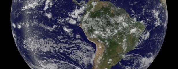
8 Biomass Burning Emissions of Aerosols Sept , 2009


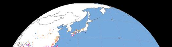
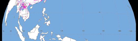
9 Same-day ETM+ and ASTER Red: ASTER Blue: TM+
10 Dete ection rate NASA ETM+ ASTER MODIS detection rates Number of 30m fire pixels ETM+: temporally biased ASTER: simultaneous Detection rates as a function of the number of 30m pixels within the pixel footprint Detection rate ETM+ ASTER Validation: impact of nonsimultaneous reference data GOES detection rates Temporally unbiased Number of 30m pixels


11 Correction for Omission Errors from Cloud Obscuration Simple approach: probability of fire under cloud cover = probability of fire over cloud-free areas Correction based on cloud fraction Probabilistic estimation: Fire climatology Precipitation Diurnal fire cycle

 (Schroeder et al.")
12 Correction for Omission Errors from Cloud Obscuration Results for WF-ABBA Cloud processing analysis 11% increment - Simple rule approach: 33% / 40% increments for 40 /120km sampling areas Basin wide increment in WF-ABBA fire detections (%) (Schroeder et al., 2008)

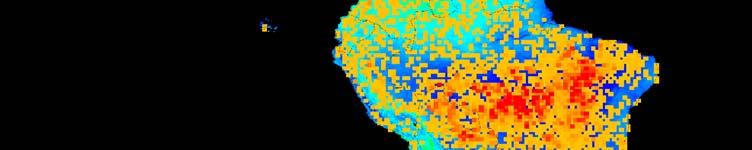
 e b - y - J g - S v - D M a r u n e p e c r CO 2 mass emission derived from GOES WF-ABBA v6.")
13 Long-term processing J a n A p r- J u l- O c t- n - F e r M a y l A u g t N o v Analysis of Long-Term Fire Dynamics and Impacts on the Amazon Using Integrated Multi-Source Fire Observations: NASA LBA-ECO Phase III LC-35 (I. Csiszar, C. Schmidt, W. Schroeder, E. Prins, A. Setzer, K. Longo, S. Freitas) e b - y - J g - S v - D M a r u n e p e c r CO 2 mass emission derived from GOES WF-ABBA v6.5 active fire data for 0-18 o S o W.


14 GOES-R Advanced Baseline Imager Builds on heritage WF- ABBA algorithm for current GOES, Met-8/-9 9, and MTSAT-1R Uses simulated ABI data created from models by CIRA and MODIS data remapped to ABI from CIMSS as proxies Product includes detection and characterization Instantaneous fire area and temperaturet Fire Radiative Power Fire detection threshold roughly 75 MW in terms of Fire Radiative Power Shaded areas correspond to probability of detection > 90%
15 Environmental Monitoring & Modelling Research Group European & African Contributions Towards a Global Geostationary Network Presented by Martin Wooster, Environmental Monitoring and Modelling Research Group Dept of Geography, King s College London, Strand, London, WC2R 2LS Contributions from W Xu (KCL) G Roberts (KCL) T Smith (KCL) Contributions from W. Xu (KCL), G. Roberts (KCL), T. Smith (KCL), J. Kaiser (ECMWF) and G. Van der Werf (VUA)


 NAfr (Northern Africa) SAfr")
 Available via FTP/EUMETCast")


16 LSA SAF Operational Meteosat Active Fire Radiative Power Product Global product generated from FRP pixel derived for different dates only as a visual example 4 Processing Regions FRP Pixel product is generated for four Regions of SEVIRI disk Euro (Europe) NAfr (Northern Africa) SAfr (Southern Africa) SAme (Southern America) Available via FTP/EUMETCast FRP_Pixel Product (native spatial/temporal resolution) available within 30 mins Gridded product - inc. adjustments for small fires and clouds also available.


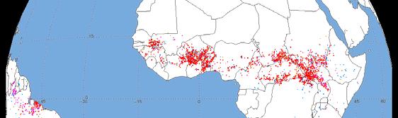
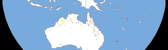
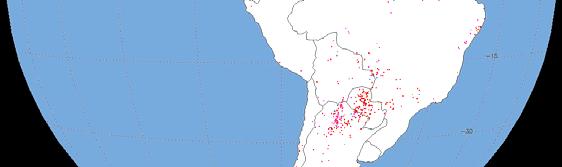
17 Prototyped: GOES Active Fire/FRP GOES 11 GOES 12 July 2007 GOES-detected fires (red) Superimposed on GLC2000


18 GOES: Fire Diurnal Cycle in Americas


")

 and extended")

19 Expected Global Geostationary System Meteosat: t GOES-E: E: GOES-W: Operational Future operational Future operational via LSA SAF currently currently KCL but available to KCL but available to users users FY2: Future CMA currently KCL Non-Optimum 3.9 µm channel data quality MTSAT: Maybe future operational currently KCL Non-Optimum 3.9 µm channel dynamic range + Future Meteosat Third Generation (2015+) will have improved temporal resolution, 2 km spatial resolution (SSP) and extended dynamic range 3.9 µm band.


 (ppb)")
20 GMES MACC D-FIRE System Fire FRP SEVIRI Emitted density Observational CO (W/m^2) (ppb) Coverage
21 Other Meteosat Active Fire Detection Algorithms & Systems Algorithms Active Fire Monitoring (FIR) algorithm (EUMETSAT MPEF) - operational - available by FTP/Eumetcast (2007 present) Fire Detection Algorithm (FiDAlgo) (Amraou et al., 2009, RSE) Active Fire Monitoring Algorithm (AFMA) (Hassini et al., 2009) MSG Data Manager fire detection algorithm (David Taylor) commercial software available for use with EUMETCast Related Novel Research Kalman Filter multi-temporal MSG fire detects (van den Bergh & Frost, 2005) Effect of SEVIRI PSF on fire detection/characterisation (Calle et al., 2009)
22 Systems using Active Fire Observations from European Sensors / Agencies 1) Advanced Fire Information System (AFIS ) ( An NRT operational fire alert and mapping system of fire activity in Africa Uses : SEVIRI and MODIS active fire products 2) African Monitoring of the Environment for Sustainable Development (AMESD) ( A continental wide, pan-african project to improve decision making-processes in environmental resource and risk management. Based on AFIS SEVIRI active fires. 3) Integrated System for Fire Risk Management (SIGRA) ( d it/) NRT detection of wildfire in the Mediterranean area using Meteosat SEVIRI. 4) European Forest Fire Information System (EFFIS) / / / f Provides a synoptic view of fires in Europe on a daily basis (based on MODIS) 5) Multi source data integration for fire management ( A prototype data assimilation system that uses a Kalman filter to integrate data from AATSR, MERIS and SEVIRI for fire detection and distribute the results to the user community (Diagne et al., 2010, IEEE GRSL)
 Purpose: Reduction of fire flashovers on South African transmission lines Method: AFIS scans a 2.")

 Screen grab from AFIS")
23 Advanced Fire Information System An NRT operational fire alert and mapping system of fire activity in Africa Instruments : MSG SEVIRI and MODIS active fire products Reference : Frost & Vosloo (2006) Purpose: Reduction of fire flashovers on South African transmission lines Method: AFIS scans a 2.5 km buffer along all transmission lines, identifying fires within buffer zones every 15 minutes. Provides: and text message system to provide rapid alert to fires. By-products: Frequency and distribution of fires in areas of interest to researchers can be reported by an automated daily . Results: 60% detection of flashover fires using AFIS (compared with 44% and 46% for just using MODIS or MSG, respectively) Screen grab from AFIS website: Web product provides fire location, intensity, location of electricity infrastructure and latest meteorological data. (

 Estimation of burned biomass based on")


24 SIGRA Satellite real-time monitoring of forest fires in Sardinia Instruments : MSG SEVIRI Reference : G. Laneve, et al., (2009) Estimation of burned biomass based on the quasi-continuous MSG/SEVIRI EO System, IGARSS Purpose: Detection of fires in Sardina Method: Detection of thermal anomalies seen in MSG SEVIRI data. Provides: Online detected hotspots. (
 Do Human-induced Fires Affect the Earth Surface reflectance at Continental Scales?")
25 Meteosat Surface Albedo & Fire Effects North Hemisphere Fire-induced perturbation 10 day temporal resolution DAYS OF 1996 Vegetation re-growth Pinty, B., Verstraete, M.M., Gobron, N., Govaerts, Y., and Roveda, F. (2000) Do Human-induced Fires Affect the Earth Surface reflectance at Continental Scales?, EOS Transactions,81,
26 International coordination for geostationary ti fire network within CGMS CGMS requirements (CGMS plenary) agency response
27 CGMS requirements Data access and pre-processing protocols Spatial resolution Pixel saturation and characterization of sensor behavior at high temperatures Data navigation Band-to-band co-registration Impact of Point Spread Function on fire detection and characterization Calibration and Validation Activities iti
28 Progress and next steps Progress has been steady, but moderate Comprehensive validation of all products Landsat-class imagery Research quality products fire masks etc. Improved data distribution system Identify fire POCs for all satellites/agencies Continued advocacy for future sensors GOES-R, MTG, etc. Better intergrate geostationary data into fire ECV Third workshop needed
Overview of the WF_ABBA Global Geostationary Fire Monitoring Program: Current Implementation and Future Plans
 Overview of the WF_ABBA Global Geostationary Fire Monitoring Program: Current Implementation and Future Plans Elaine M. Prins Consultant Christopher C. Schmidt Jay Hoffman Jason Brunner UW-Madison SSEC
A temporal active fire detection algorithm applied to geostationary satellite observations
 8 th 10 th June LSA-SAF Workshop 2015 A temporal active fire detection algorithm applied to geostationary satellite observations Gareth Roberts (University of Southampton) Outline Active fire detection
GOES-R AWG Land Team: Fire Detection and Characterization
 GOES-R AWG Land Team: Fire Detection and Characterization June 8, 2010 Presented By: Christopher C. Schmidt 1 1 UW-Madison/SSEC/CIMSS 1 FIRE Product Team AWG Land Team Chair: Yunyue (Bob) Yu FIRE Product
The operational MSG SEVIRI fire radiative power products generated at the Land-SAF
 Environmental Monitoring & Modelling Research Group The operational MSG SEVIRI fire radiative power products generated at the Land-SAF Martin Wooster, Gareth Roberts, Weidong Xu, Patrick Freeborn, Jianping
GOFC/GOLD Fire IT Strategic Planning. Day 1 - Break Out Group Discussion
 GOFC/GOLD Fire IT Strategic Planning Day 1 - Break Out Group Discussion Aims of the Fire IT refining and articulating the international requirements for fire related observations making the best possible
Elaine M. Prins* NOAA/NESDIS, Office of Research and Applications, Advanced Satellite Products Branch (ASPB) Madison, WI
 Madison, WI") P4.6 Global Geostationary Fire Monitoring System Elaine M. Prins* NOAA/NESDIS, Office of Research and Applications, Advanced Satellite Products Branch (ASPB) Madison, WI Donna McNamara NOAA/NESDIS, Office
P4.6 Global Geostationary Fire Monitoring System Elaine M. Prins* NOAA/NESDIS, Office of Research and Applications, Advanced Satellite Products Branch (ASPB) Madison, WI Donna McNamara NOAA/NESDIS, Office
[Some] Updates on Research into Fire Radiative Power & Energy
![[Some] Updates on Research into Fire Radiative Power & Energy](/thumbs/89/100768239.jpg "[Some] Updates on Research into Fire Radiative Power & Energy") Environmental Monitoring & Modelling Research Group [Some] Updates on Research into Fire Radiative Power & Energy Presented by Martin Wooster (Kings College London, UK) Slide contributions from many others
Environmental Monitoring & Modelling Research Group [Some] Updates on Research into Fire Radiative Power & Energy Presented by Martin Wooster (Kings College London, UK) Slide contributions from many others
PARALLEL USE OF SEVIRI LSA SAF FRP AND MPEF FIR PRODUCTS FOR FIRE DETECTION AND MONITORING
 PARALLEL USE OF SEVIRI LSA SAF FRP AND MPEF FIR PRODUCTS FOR FIRE DETECTION AND MONITORING C. G. Georgiev, J. S. Stoyanova National Institute of Meteorology and Hydrology, Bulgarian Academy of Sciences
Global Biomass Burning Emissions from a Constellation of Geostationary Satellites for Global Model Forecast Applications
 1 Global Biomass Burning Emissions from a Constellation of Geostationary Satellites for Global Model Forecast Applications Shobha Kondragunta NOAA/NESDIS Center for Satellite Applications and Research
Supplement of LSA SAF Meteosat FRP products Part 1: Algorithms, product contents, and analysis
 Supplement of Atmos. Chem. Phys., 15, 13217 13239, 2015 http://www.atmos-chem-phys.net/15/13217/2015/ doi:10.5194/acp-15-13217-2015-supplement Author(s) 2015. CC Attribution 3.0 License. Supplement of
SEVIRI/MSG sensor early fire detection performances assessment
 SEVIRI/MSG sensor early fire detection performances assessment G. Laneve, E. Cadau CRPSM Università di Roma La Sapienza e-mail: laneve@psm.uniroma1.it 2 nd GOFC/GOLD Workshop on GEO Fire Monitoring, Darmstadt,
GOFC-GOLD Fire An Overview
 GOFC-GOLD Fire An Overview Providing the International Coordination needed for Global Observation of Forest, Fire and Land Cover Dynamics. Krishna Prasad Vadrevu GOFC Fire Implementation Team (IT) Executive
Interim evaluation of the New IR Sensor Technology (NIRST) as a wildfire monitoring tool
 as a wildfire monitoring tool") Interim evaluation of the New IR Sensor Technology (NIRST) as a wildfire monitoring tool Joshua Johnston Forest Fire Analyst Canadian Forest Service Great Lakes Forestry Centre Sault Ste. Marie, Ontario
Interim evaluation of the New IR Sensor Technology (NIRST) as a wildfire monitoring tool Joshua Johnston Forest Fire Analyst Canadian Forest Service Great Lakes Forestry Centre Sault Ste. Marie, Ontario
Use of new spatially refined satellite remote sensing fire detection data in support of advanced wildfire mapping and modeling
 Use of new spatially refined satellite remote sensing fire detection data in support of advanced wildfire mapping and modeling Dr. Wilfrid Schroeder 1 Dr. Janice Coen 2 Dr. Patricia Oliva 1 Dr. Louis Giglio
Review of MTG FDHSI Mission Requirements Regarding Fire Applications
 Review of MTG FDHSI Mission Requirements Regarding Fire Applications Dr M.J. Wooster and Dr G. Roberts Environmental Monitoring and Modelling Group, Department of Geography King s College London Document
DETECTION AND MONITORING OF ACTIVE FIRES USING REMOTE SENSING TECHNIQUES
 DETECTION AND MONITORING OF ACTIVE FIRES USING REMOTE SENSING TECHNIQUES Source: Unknown n.d., http://www.hotrodsandclassics.net/featuredpictures/featurepictures2.htm. by Claire Riddell DETECTION AND MONITORING
Fire-Implementation Team (Fire-IT) Update and Future Steps
 Update and Future Steps") Global Observation of Forest and Land Cover Dynamics Fire-Implementation Team (Fire-IT) Update and Future Steps Fire-IT Co-Chair: Chris Justice (U. Maryland) Fire-IT Executive Officer: Krishna Vadrevu
Global Observation of Forest and Land Cover Dynamics Fire-Implementation Team (Fire-IT) Update and Future Steps Fire-IT Co-Chair: Chris Justice (U. Maryland) Fire-IT Executive Officer: Krishna Vadrevu
Advanced Fire Information System
 Advanced Fire Information System Karen Steenkamp Philip Frost CSIR Meraka Institute www.sac.co.za Meraka Institute - RSRU RSRU Mission: To conduct basic and applied remote sensing research for the advancement
Development of a Canadian Wildland Fire Monitoring Sensor (CWFMS)
") Unclassified Development of a Canadian Wildland Fire Monitoring Sensor (CWFMS) Helena (Marleen) van Mierlo 1 Linh Ngo Phong 1 Steeve Montminy 1 Joshua M. Johnston 2 Denis Dufour 3 (1) Canadian Space Agency
Unclassified Development of a Canadian Wildland Fire Monitoring Sensor (CWFMS) Helena (Marleen) van Mierlo 1 Linh Ngo Phong 1 Steeve Montminy 1 Joshua M. Johnston 2 Denis Dufour 3 (1) Canadian Space Agency
P1.9 CHARACTERIZING AND UNDERSTANDING THE DIFFERENCES BETWEEN GOES WF_ABBA AND MODIS FIRE PRODUCTS AND IMPLICATIONS FOR DATA ASSIMILATION
 P1.9 CHARACTERIZING AND UNDERSTANDING THE DIFFERENCES BETWEEN GOES WF_ABBA AND MODIS FIRE PRODUCTS AND IMPLICATIONS FOR DATA ASSIMILATION Jay P. Hoffman 1 *, Elaine M. Prins 1, Christopher C. Schmidt 1,
Recent Developments and Prospects for Innovative Remote Sensing of High-Temperature Events and Vegetation Fire Impacts
 Recent Developments and Prospects for Innovative Remote Sensing of High-Temperature Events and Vegetation Fire Impacts by D. Oertel, E. Lorenz, B. Zhukov German Aerospace Center, (DLR-OS) Berlin Adlershof
S-NPP/VIIRS and Landsat-8/OLI Global Active Fire Data Sets
 S-NPP/VIIRS and Landsat-8/OLI Global Active Fire Data Sets Wilfrid Schroeder Louis Giglio, Pierre Guillevic, William Walsh (Dept of Geographical Sciences/UMD) Janice Coen (NCAR/Boulder) Ivan Csiszar (NOAA/NESDIS/STAR)
I. INTRODUCTION. Index Terms Fires, satellites.
 248 IEEE JOURNAL OF SELECTED TOPICS IN APPLIED EARTH OBSERVATIONS AND REMOTE SENSING, VOL. 1, NO. 4, DECEMBER 2008 Short-Term Observations of the Temporal Development of Active Fires From Consecutive Same-Day
Analysing Threshold Value in Fire Detection Algorithm Using MODIS Data
 RESEARCH PAPER Analysing Threshold Value in Fire Detection Algorithm Using MODIS Data 1 Bowo E. Cahyono, 2 Peter Fearns, and 3 Brendon McAtee 1 Department of Physics, Jember University, Indonesia; 2 Department
Physical concepts. Remote sensing of fires and vegetation. Applications of SEVIRI channels.
 Physical concepts Remote sensing of fires and vegetation Applications of SEVIRI channels jose.prieto@eumetsat.int Contents Applications of SEVIRI channels Characteristics of the 3.9µm channel Differences
Fire Detection and Monitoring
 Fire Detection and Monitoring Akli Benali Forest Research Center, University of Lisbon aklibenali@gmail.com Conference & Summer School on Forest Fire Management Istituto Superiore Antincendi, Rome, September
History and update on satellite remote sensing of fires
 History and update on satellite remote sensing of fires Chris Justice and Krishna Vadrevu Dept. Geographcial of Sciences, University of Maryland, GOFC GOLD Fire Implementation Team Fires and smoke in Indonesia
FIRE DETECTION AND PARAMETERIZATION WITH MSG-SEVIRI SENSOR
 FIRE DETECTION AND PARAMETERIZATION WITH MSG-SEVIRI SENSOR A. Calle, J.L. Casanova, Moclán, C., Romo, A. and Fraile, S. Remote Sensing Laboratory of University of Valladolid. Dept. Applied Physic. Faculty
Satellite Derived Fire Products for Biomass Burning Studies
 Satellite Derived Fire Products for Biomass Burning Studies Chris Justice University of Maryland and colleagues Fires in Indochina April 6 2010 ( NASA MODIS Aqua) THE GLOBAL FIRE PRODUCT (1992 93) bioval.jrc.ec.europa.eu/
Fire Information for Resource Management System (FIRMS)
") Fire Information for Resource Management System (FIRMS) Diane Davies 1, Chris Justice 1, Jacques Descloitres 2, John Latham 3 John Musinsky 4 1 Department of Geography, University of Maryland 2 SSAI /
Fire Information for Resource Management System (FIRMS) Diane Davies 1, Chris Justice 1, Jacques Descloitres 2, John Latham 3 John Musinsky 4 1 Department of Geography, University of Maryland 2 SSAI /
16.10 Johannes Kaiser HALO Proposal
 MINUTES OF THE DISCUSSION SESSION ON WILDFIRES & BIOMASS BURNING at the GEMS Annual Assembly 2006: Monday, 6th February, 13.30-17.00 Minutes by: Christiane Textor, Johannes Kaiser, and Martin Schultz AGENDA
Verification and Validation of OOV-TET1 Multispectral Camera Observations within the FireBIRD Project
 DLR.de Chart 1 Verification and Validation of OOV-TET1 Multispectral Camera Observations within the FireBIRD Project O. Frauenberger **, A. Börner *, E. Borg **, W Halle *, E. Lorenz *, S. Mitchell *,
VIIRS FIRE PRODUCTS UPDATE
 VIIRS FIRE PRODUCTS UPDATE Ivan Csiszar 1, Wilfrid Schroeder 2, Louis Giglio 2, Brad Wind 2, Evan Ellicott 2, Christopher O. Justice 2 1 NOAA/NESDIS Center for Satellite Applications and Research, Camp
Methods of detecting burnt area and estimating emissions Dr. Kevin Tansey
 Methods of detecting burnt area and estimating emissions Dr. Kevin Tansey (kjt7@le.ac.uk) Why fire is important Emitter of GHG and aerosols into the atmosphere Stohl, A. et al., 2006, record high air pollution
Long-term Inventory of Fire Burned Areas and Emissions of North America s Boreal and Temperate Forests
 Long-term Inventory of Fire Burned Areas and Emissions of North America s Boreal and Temperate Forests P.Gong, Z. Li, I. Csiszar, W. Hao, R. Fraser J.Z. Jin, R. Pu Objectives 1. Map burn scars in boreal
FIRE DETECTION AND MONITORING USING AVHRRA AND MSG SYSTEMS. Version Tuesday, 1.0, 1530 November Slide: 1
 FIRE DETECTION AND MONITORING USING AVHRRA AND MSG SYSTEMS Version Tuesday, 1.0, 1530 November 2005 2004 Slide: 1 Botswana early warning system Version Tuesday, 1.0, 1530 November 2005 2004 Slide: 2 Objectives
Sentinel Asia Wildfire Monitoring
 Sentinel Asia Wildfire Monitoring Masami FUKUDA Institute of Low Temp. Sci. Hokkaido Univ. 3rd Sentinel Asia JPT Meeting 13 March 2007, Singapore Objective of Sentinel Asia Wildfire Monitoring Contribution
There are various resources and toolkits available to perform this task.
 Hands-On Exercise: Wildfires in Chile, January 2017 Task description Imagine you are analyst that has been assigned to the fire Las Maquinas burning in the vicinity of Constitución, in the Maule region
Google-Earth use as a monitoring tool for EUMETSAT s active fire product
 Google-Earth use as a monitoring tool for EUMETSAT s active fire product Assist.Prof. İbrahim SÖNMEZ Ondokuz Mayıs University Department of Meteorology Samsun, TURKEY isonmez@omu.edu.tr 1 OUTLINE Google-Earth
SAF for Land Surface Analysis (LSA SAF)
") SAF for Land Surface Analysis (LSA SAF) VALIDATION REPORT Fire Radiative Power (LSA-502 and LSA-503) Reference Number: SAF/LAND/IM/VR_FRP/V_10 Issue/Revision Index: Issue I/2015 FRP Pixel Algorithm Version:
SAF for Land Surface Analysis (LSA SAF) VALIDATION REPORT Fire Radiative Power (LSA-502 and LSA-503) Reference Number: SAF/LAND/IM/VR_FRP/V_10 Issue/Revision Index: Issue I/2015 FRP Pixel Algorithm Version:
Session 2: LSA-SAF evapotranspiration: files, format and applications
 Application of remote sensing data for drought monitoring Introduction to EUMETSAT Land SAF products Wednesday November 13, 2013 Session 2: LSA-SAF evapotranspiration: files, format and applications 1.
P7.3 RECENT VALIDATION STUDIES OF THE GOES WILDFIRE AUTOMATED BIOMASS BURNING ALGORITHM (WF_ABBA) IN NORTH AND SOUTH AMERICA
 IN NORTH AND SOUTH AMERICA") P7.3 RECENT VALIDATION STUDIES OF THE GOES WILDFIRE AUTOMATED BIOMASS BURNING ALGORITHM (WF_ABBA) IN NORTH AND SOUTH AMERICA Joleen M. Feltz* Cooperative Institute for Meteorological Satellite Studies,
P7.3 RECENT VALIDATION STUDIES OF THE GOES WILDFIRE AUTOMATED BIOMASS BURNING ALGORITHM (WF_ABBA) IN NORTH AND SOUTH AMERICA Joleen M. Feltz* Cooperative Institute for Meteorological Satellite Studies,
Global fire hotspots detected by NASA satellite to help United Nations
 Global fire hotspots detected by NASA satellite to help United Nations Published on 24 Sep 2010 is Image NASA's not found Moderate or type unknown Resolution Imaging Spectroradiometer (MODIS), an instrument
Rapid Prototyping of NASA Next Generation Sensors for the SERVIR System of Fire Detection in Mesoamerica
 Rapid Prototyping of NASA Next Generation Sensors for the SERVIR System of Fire Detection in Mesoamerica Joel S. Kuszmaul, Henrique Momm, Greg Easson University of Mississippi, University, MS 38677 Timothy
Daytime Fire Detection Using Airborne Hyperspectral Data Philip E. Dennison 1 and Dar A. Roberts 2. University of Utah, Salt Lake City, UT 84112, USA
 Daytime Fire Detection Using Airborne Hyperspectral Data Philip E. Dennison 1 and Dar A. Roberts 2 1 Department of Geography and Center for Natural and Technological Hazards, University of Utah, Salt Lake
CO 2, CH 4 and CO Observa0ons from CrIS on S-NPP and JPSS-1
 CO 2, CH 4 and CO Observa0ons from CrIS on S-NPP and JPSS-1 Xiaozhen (Shawn) Xiong 1,2, Lihang Zhou 2 Antonia Gambacorta 1,3, Nick Nalli 1,2, Changyi Tan 1,2 Flavio Iturbide-Sanchez 1,2, Kexing Zhang 1,2
Land SAF LSA-SAF Evapotranspiration (ET) Product
 Product") Land SAF LSA-SAF Evapotranspiration (ET) Product Alirio Arboleda Budapest 25 April 2017 In collaboration with: Nicolas Ghilain and Françoise Gellens-Meulenberghs Royal Météorological Institute of Belgium
Land SAF LSA-SAF Evapotranspiration (ET) Product Alirio Arboleda Budapest 25 April 2017 In collaboration with: Nicolas Ghilain and Françoise Gellens-Meulenberghs Royal Météorological Institute of Belgium
GOES-R ABI Emissive IR Bands Radiometric Performance Monitoring and Trending
 GOES-R ABI Emissive IR Bands Radiometric Performance Monitoring and Trending Haifeng Qian a, Robert Iacovazzi a, Xiangqian Wu b, Boryana Efremova a, Fangfang Yu a, Xi Shao a a ERT, Inc. Laurel, MD 20707
3rd GWIS and GOFC-GOLD Fire IT meeting 1st-2nd October 2018, University of Maryland, Agenda v.0
 3rd GWIS and GOFC-GOLD Fire IT meeting 1st-2nd October 2018, University of Maryland, Agenda v.0 Meeting Venue Earth System Science Interdisciplinary Center (ESSIC) University of Maryland Research Park
 www.inpe.br/queimadas This (short) presentation will stress: - Interaction with users; - GOES-16 detections A system with dozens of diferent products www.inpe.br/queimadas Our new portal CIMAN combines
BEYOND for atmospheric hazards monitoring and forecasting
 BEYOND for atmospheric hazards monitoring and forecasting V. Amiridis, S. Solomos, A. Tsekeri, E. Marinou, S. Kazadzis, E. Gerasopoulos, T. Herekakis, C. Kontoes Atmospheric hazards in BEYOND Examples
THE NORTHSTAR SYSTEM: A NEW ERA IN EARTH OBSERVATION
 THE NORTHSTAR SYSTEM: A NEW ERA IN EARTH OBSERVATION Daniel O Connell 1, Derek R. Peddle 2, 6, Stewart Bain 3, Douglas W. Bancroft 4, Kjell Stakkestad 5,7 NorthStar, Montréal, Québec, Canada. http://www.northstar-data.com
Detection and analysis of high-temperature events in the BIRD mission
 Acta Astronautica 56 (2005) 65 71 www.elsevier.com/locate/actaastro Detection and analysis of high-temperature events in the BIRD mission Boris Zhukov, Klaus Briess, Eckehard Lorenz, Dieter Oertel, Wolfgang
Band Selection & Algorithm Development for Remote Sensing of Wildland Fires
 Band Selection & Algorithm Development for Remote Sensing of Wildland Fires Andy Fordham Chester F. Carlson Center for Imaging Science Rochester Institute of Technology Rochester, New York 14623-5604 ajf8207@cis
Results on verification and validation of OOV-TET1 multispectral camera observations within the FireBIRD project
 Results on verification and validation of OOV-TET1 multispectral camera observations within the FireBIRD project O. Frauenberger **, E. Borg **, A. Börner *, W Halle *, E. Lorenz *, S. Mitchell *, C. Paproth
A Review of AVHRR-based Active Fire Detection Algorithms: Principles, Limitations, and Recommendations
 A Review of AVHRR-based Active Fire Detection Algorithms: Principles, Limitations, and Recommendations Z. Li 1, Y. J. Kaufman 2, C. Ichoku 2, R. Fraser 1, A. Trishchenko 1, L. Giglio 2, J. Jin 1, X. Yu
University of Puerto Rico at Mayagüez Direct Broadcast Polar Orbiter Workshop
 University of Puerto Rico at Mayagüez Direct Broadcast Polar Orbiter Workshop 27 April 2016 Lab 2 Part 4: Investigating VIIRS and MODIS Fire Detection Capabilities 1.1. Use Hydra to open the VIIRS directory
Validating the TET-1 satellite sensing system in detecting and characterizing active fire hotspots
 Validating the TET-1 satellite sensing system in detecting and characterizing active fire hotspots A thesis submitted in fulfilment of the requirements for the degree of Master of Science Simon Stuart
Sentinel Asia. Disaster Management Support System. Wild Fire Working Group
 Sentinel Asia Disaster Management Support System Wild Fire Working Group Impact to future global warming Carbon Cycle Sink Source Contribution to Kyoto Protocol Sustainable Forest Management Reports on
Using VIIRS Direct Readout Capabilities for the Improvement of Mexico's Wild Fire Alert System
 Using VIIRS Direct Readout Capabilities for the Improvement of Mexico's Wild Fire Alert System Juan M. Escamilla Mólgora 1 National Commission for Knowledge and Use of Biodiversity CONABIO - Mexico 1 CSPP/IMAPP
the EU-Japan Support Mission in the Space Sector
 Astro- und Feinwerktechnik Adlershof GmbH the EU-Japan Support Mission in the Space Sector 07 th of September 2017 Sapporo, Japan Dr.-Ing. Sebastian Scheiding s.scheiding@astrofein.com www.astrofein.com
Forest fire detection based on MODIS satellite imagery, and Comparison of NOAA satellite imagery with fire fighters' information
 Forest fire detection based on MODIS satellite imagery, and Comparison of NOAA satellite imagery with fire fighters' information *Koji Nakau, Masami Fukuda, Keiji Kushida, Hiroshi Hayasaka, Keiji Kimura,
EARLINET products for model evaluation and assimilation
 EARLINET products for model evaluation and assimilation Ioannis Binietoglou and EARLINET 1 National Observatory of Athens, Greece 2 National Institute for R&D in Optoelectronics, Romania 2 EARLINET research
National Infrared Operations (NIROPS) Program Overview. Tom Mellin National Infrared Program Manager
 Program Overview. Tom Mellin National Infrared Program Manager") National Infrared Operations (NIROPS) Program Overview Tom Mellin National Infrared Program Manager Topics NIROPS organization Phoenix imaging system Aircraft Data delivery to infrared interpreters IRIN
National Infrared Operations (NIROPS) Program Overview Tom Mellin National Infrared Program Manager Topics NIROPS organization Phoenix imaging system Aircraft Data delivery to infrared interpreters IRIN
RAPID FIRE DETECTION IN MEXICO AND CENTRAL AMERICA USING REMOTE SENSING METHODS
 RAPID FIRE DETECTION IN MEXICO AND CENTRAL AMERICA Bart Wickel Gerardo Lopez Ma. Isabel Cruz Erik de Badts Raúl Jimenez Rosenberg Comisión nacional para el conocimiento y uso de la biodiversidad Organization
Standardization of Remote Sensing Technology. Yuan-Yuan Jia. Academy of Opto-Electronics (AOE), CAS
, CAS") WGCV-36 Shanghai, China May 13-17, 2013 Standardization of Remote Sensing Technology Yuan-Yuan Jia 1 Academy of Opto-Electronics (AOE), CAS 2 Secretariat of National Technical Committee 327 on RS of Standardization
WGCV-36 Shanghai, China May 13-17, 2013 Standardization of Remote Sensing Technology Yuan-Yuan Jia 1 Academy of Opto-Electronics (AOE), CAS 2 Secretariat of National Technical Committee 327 on RS of Standardization
3. Managing smoke: Our strategies and opportunities
 3. Managing smoke: Our strategies and opportunities Dr. Zifei Liu zifeiliu@ksu.edu Pasture burning smoke management and air quality workshop March 28 th, 2015 Engineering Two strategies for reduction Minimize
ALBERTA FOREST PROTECTION THERMAL INFRARED PROGRAM
 ALBERTA FOREST PROTECTION THERMAL INFRARED PROGRAM Eleventh Biennial USDA Forest Service Remote Sensing Applications Conference Salt Lake City, Utah April 25 Ken Dutchak, P. Biol. Reconnaissance and Remote
Automated Fire and Flood Hazard Protection System
 De la Riva, J., Pérez-Cabello, F. & Chuvieco, E. (Eds) 2005 Proceedings of the 5 th International Workshop on Remote Sensing and GIS Applications to Forest Fire Management: Fire Effects Assessment: 167-172
Study for Monitoring of Fires in the Mediterranean Area by Geostationary
 Executive Summary Telespazio Document No.: 190.191.40-SPA-ES-001 Issue 1.0 Study for Monitoring of Fires in the Mediterranean Area by Geostationary and Polar Satellites Prepared by: ESA/Contract No. 14496/00/I-IW,
The Role of Satellite Observations in Assessing Impacts of Wildfire Occurrence on Respiratory Health of Population
 The Role of Satellite Observations in Assessing Impacts of Wildfire Occurrence on Respiratory Health of Population Tatiana Loboda University of Maryland Outline Wildfire and human health Interdisciplinary
Estimating Fire Properties by Remote Sensing 1.
 Estimating Fire Properties by Remote Sensing 1. Philip J. Riggan USDA Forest Service Pacific Southwest Research Station 4955 Canyon Crest Drive Riverside, CA 92507 909 680 1534 PJRiggan@IBM.net James W.
The Compact Muon Solenoid Experiment. Conference Report. Mailing address: CMS CERN, CH-1211 GENEVA 23, Switzerland
 Available on CMS information server CMS CR -2016/298 The Compact Muon Solenoid Experiment Conference Report Mailing address: CMS CERN, CH-1211 GENEVA 23, Switzerland 28 October 2016 (v2, 25 November 2016)
Evaluation of remote sensing-based active fire datasets in Indonesia
 INT. J. REMOTE SENSING, 20JANUARY, 2004, VOL. 25, NO. 2, 471 479 Evaluation of remote sensing-based active fire datasets in Indonesia F. STOLLE*{, R. A. DENNIS{, I. KURNIWAN{ and E. F. LAMBIN {Global Forest
DEMONSTRATION OF A SEMI-OPERATIONAL FIRE RECOGNITION SERVICE USING BIRD MICRO- SATELLITE - DEMOBIRD
 DEMONSTRATION OF A SEMI-OPERATIONAL FIRE RECOGNITION SERVICE USING BIRD MICRO- SATELLITE - DEMOBIRD Jesús Gonzalo, Gonzalo Martín de Mercado Ingeniería y Servicios Aeroespaciales, S.A. (INSA), Spain Paseo
A Forest Fire Warning Method Based on Fire Dangerous Rating Dan Wang 1, a, Lei Xu 1, b*, Yuanyuan Zhou 1, c, Zhifu Gao 1, d
 International Conference on Applied Science and Engineering Innovation (ASEI 2015) A Forest Fire Warning Method Based on Fire Dangerous Rating Dan Wang 1, a, Lei Xu 1, b*, Yuanyuan Zhou 1, c, Zhifu Gao
The New DUSTTRAK II and DRX Aerosol Monitors
 The New DUSTTRAK II and DRX Aerosol Monitors HEALTH AND SAFETY Exposure Monitoring TRUST. SCIENCE. INNOVATION. Real-Time Dust Monitoring Takes A Giant Leap Forward. The Revolution in Real-Time Dust Monitoring
All users are recommended to update their existing ProRAE Guardian (PRG) software to v
 software to v") Product ProRAE Guardian Version V1.14.4 Release Date January 2018 All users are recommended to update their existing ProRAE Guardian (PRG) software to v1.14.4. 1. Experion Field Personnel Safety (FPS)
Product ProRAE Guardian Version V1.14.4 Release Date January 2018 All users are recommended to update their existing ProRAE Guardian (PRG) software to v1.14.4. 1. Experion Field Personnel Safety (FPS)
JST-JICA Project Wild Fire and Carbon Management in Peat-Forest in Indonesia
 2011.07.13 JPTM2011 Putrajaya Status of JST/JICA Peat and Carbon Management Project Toshihisa HONMA (Hokkaido Univ.) JST-JICA Project Wild Fire and Carbon Management in Peat-Forest in Indonesia Hokkaido
The New DUSTTRAK II and DRX Aerosol Monitors
 The New DUSTTRAK II and DRX Aerosol Monitors HEALTH AND SAFETY Exposure Monitoring TRUST. SCIENCE. INNOVATION. Real-Time Dust Monitoring Takes A Giant Leap Forward. The Revolution in Real-Time Dust Monitoring
The FireBird mission - a scientific mission for Earth observation and hot spot detection
 The FireBird mission - a scientific mission for Earth observation and hot spot detection Terzibaschian, Thomas Reile, H., Lorenz, E. DLR, Germany 9th IAA SYMPOSIUM ON SMALL SATELLITES FOR EARTH OBSERVATION,
Product data sheet Palas Fidas 200 S
 Product data sheet Palas Fidas 200 S Applications Regulatory environmental monitoring in measuring networks Ambient air measurement campaigns Oriented indicative measurements (spot checks) Long-term studies
Digital soil mapping from legacy data and hyperspectral imagery in CapBon (Tunisia) First results and perspectives.
 First results and perspectives.") Digital soil mapping from legacy data and hyperspectral imagery in CapBon (Tunisia) First results and perspectives. Philippe Lagacherie 1, Cécile Gomez 2, Sinan Bacha 4, Rossano Ciampalini 2, Hedi Hamrouni
Digital soil mapping from legacy data and hyperspectral imagery in CapBon (Tunisia) First results and perspectives. Philippe Lagacherie 1, Cécile Gomez 2, Sinan Bacha 4, Rossano Ciampalini 2, Hedi Hamrouni
CROWD-SOURCED REMOTE ASSESSMENTS OF REGIONAL-SCALE POST-DISASTER DAMAGE
 Eleventh U.S. National Conference on Earthquake Engineering Integrating Science, Engineering & Policy June 25-29, 2018 Los Angeles, California CROWD-SOURCED REMOTE ASSESSMENTS OF REGIONAL-SCALE POST-DISASTER
Wildfire Mapping Using FireBIRD Data
 Wildfire Mapping Using FireBIRD Data Global Wildfire Information System (GWIS) GOFC GOLD Fire IT 20-23 rd November 2017, Cumberland Lodge Christian Fischer on behalf of the FireBIRD-Team German Aerospace
Enhancing our Nation s Wildfire Management Capabilities Through Application of NASA Science and Technology
 Enhancing our Nation s Wildfire Management Capabilities Through Application of NASA Science and Technology Vince Ambrosia Earth Science Division. Biospherics Branch NASA-Ames Research Center 2nd Annual
PUBLICATIONS. Journal of Geophysical Research: Atmospheres
 PUBLICATIONS RESEARCH ARTICLE Key Points: We compared the 2011 HMS fire pixels to ground-based fire records in Georgia The fire detection rate increases from 3% to 80% with the increase of fire size Detection
Validation of MODIS Active Fire Detection Products Derived from Two Algorithms
 Earth Interactions Volume 9 (2005) Paper No. 9 Page 1 Copyright 2005, Paper 09-009; 7,505 words, 11 Figures, 0 Animations, 2 Tables. http://earthinteractions.org Validation of MODIS Active Fire Detection
Urbanization dynamics along the Belt and Road
 Human Planet Forum Enschede, Netherlands 12-15 September 2017 Urbanization dynamics along the Belt and Road Linlin Lu Key Lab. of Digital Earth Science Institute of Remote Sensing and Digital Earth, Chinese
NEAR REAL TIME DETECTION OF BURNED SCAR AREA USING LANDSAT-8 IMAGERIES
 NEAR REAL TIME DETECTION OF BURNED SCAR AREA USING LANDSAT-8 IMAGERIES Danang Surya Candra Kustiyo - Indonesian National Institute of Aeronautics and Space (LAPAN) - Outline INTRODUCTION: Background, Problems,
Using Remote sensing technique for estimation of real evapotranspiration
 Using Remote sensing technique for estimation of real evapotranspiration Hassan Fathizad, Bijan Azad, Ali Yousefi, Azin jafarian Abstract Evapotranspiration is not easy to measure; Specific devices and
Space-borne high resolution fire remote sensing in Benin, West Africa
 INT. J. REMOTE SENSING, 10 JUNE, 2004, VOL. 25, NO. 11, 2209 2216 Space-borne high resolution fire remote sensing in Benin, West Africa D. OERTEL, B. ZHUKOV DLR-Institute of Space Sensor Technology and
DISASTER LANDSCAPE ATTRIBUTION
 DISASTER LANDSCAPE ATTRIBUTION Annual report 2016-2017 Prof. Simon Jones, Dr Karin Reinke & Dr Luke Wallace School of Mathematics and Geospatial Science, RMIT University Version Release history Date 1.0
Customized LIDARs. Research Pollution Climate. Raman, Depolarization, Backscatter, DIAL
 Customized LIDARs Research Pollution Climate Raman, Depolarization, Backscatter, DIAL Raymetrics Introduction Raymetrics was founded in 2002 with the aim of manufacturing the highest quality scientific
Time Domain THz Spectroscopy and Related Sensing Applications
 VG03-077 Time Domain THz Spectroscopy and Related Sensing Applications David J. Cook, Brian K. Decker, Gami Dadusc, and Mark G. Allen Physical Sciences Inc. 20 New England Business Center Andover, MA June
Atmospheric Super Test Beam for the Pierre Auger Observatory
 Atmospheric Super Test Beam for the Pierre Auger Observatory L. Wiencke for the Pierre Auger Collaboration and A. Botts, C. Allan, M. Calhoun, B. Carande, M. Coco, J. Claus, L. Emmert, S. Esquibel, L.
Fire Detection Using Image Processing
 Fire Detection Using Image Processing Ku. R.A.Agrawal ME Student Department of CSE Babasaheb Naik college of Engineering Pusad, India rachanaagrawal90@gmail.com Prof. S.T.Khandare Associate professor Department
DEVELOPMENT OF THE INFRARED INSTRUMENT FOR GAS DETECTION
 DEVELOPMENT OF THE INFRARED INSTRUMENT FOR GAS DETECTION Ching-Wei Chen 1, Chia-Ray Chen 1 1 National Space Organization, National Applied Research Laboratories ABSTRACT MWIR (Mid-Wave Infrared) spectroscopy
International Journal of Scientific & Engineering Research, Volume 7, Issue 7, July ISSN
 International Journal of Scientific & Engineering Research, Volume 7, Issue 7, July-2016 554 Forest Fire Detection using Wireless Sensor Harjinder Singh Department of Instrumentation and Control Engineering,
Ozone and Atmospheric Chemistry Monitoring SAF (O3M SAF)
") Ozone and Atmospheric Chemistry Monitoring SAF (O3M SAF) EUMETSAT SAF Network Workshop 14-16 January 2008 Jukka Kujanpää, FMI Overview of O3M SAF SAF on Ozone and Atmospheric Chemistry Monitoring Part
Ozone and Atmospheric Chemistry Monitoring SAF (O3M SAF) EUMETSAT SAF Network Workshop 14-16 January 2008 Jukka Kujanpää, FMI Overview of O3M SAF SAF on Ozone and Atmospheric Chemistry Monitoring Part