|
|
|
- Horace Gordon
- 5 years ago
- Views:
Transcription
1
2
3
4
5
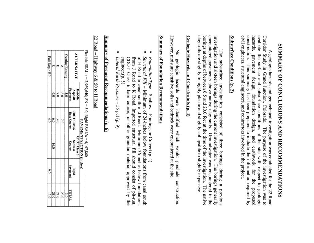
6
7
8
9
10
11
12
13
14
15
16
17
18
19
20

21 108 40' 29'' W Soil Map Mesa County Area, Colorado ' 55'' W 39 10' 11'' N 39 6' 31'' N ' 11'' N 39 6' 31'' N ' 29'' W N Map Scale: 1:33,200 if printed on A portrait (8.5" x 11") sheet. Meters Feet Map projection: Web Mercator Corner coordinates: WGS84 Edge tics: UTM Zone 12N WGS ' 55'' W Natural Resources Conservation Service Web Soil Survey National Cooperative Soil Survey 4/30/2014 Page 1 of 3
22 Soil Map Mesa County Area, Colorado MAP LEGEND MAP INFORMATION Area of Interest (AOI) Area of Interest (AOI) Soils Soil Map Unit Polygons Soil Map Unit Lines Soil Map Unit Points Special Point Features Blowout Borrow Pit Clay Spot Closed Depression Gravel Pit Gravelly Spot Landfill Lava Flow Marsh or swamp Mine or Quarry Miscellaneous Water Perennial Water Rock Outcrop Saline Spot Sandy Spot Severely Eroded Spot Sinkhole Slide or Slip Sodic Spot Spoil Area Stony Spot Very Stony Spot Wet Spot Other Special Line Features Water Features Streams and Canals Transportation Rails Interstate Highways US Routes Major Roads Local Roads Background Aerial Photography The soil surveys that comprise your AOI were mapped at 1:24,000. Please rely on the bar scale on each map sheet for map measurements. Source of Map: Natural Resources Conservation Service Web Soil Survey URL: Coordinate System: Web Mercator (EPSG:3857) Maps from the Web Soil Survey are based on the Web Mercator projection, which preserves direction and shape but distorts distance and area. A projection that preserves area, such as the Albers equal-area conic projection, should be used if more accurate calculations of distance or area are required. This product is generated from the USDA-NRCS certified data as of the version date(s) listed below. Soil Survey Area: Mesa County Area, Colorado Survey Area Data: Version 4, Jan 2, 2014 Soil map units are labeled (as space allows) for map scales 1:50,000 or larger. Date(s) aerial images were photographed: Jun 22, 2010 Sep 2, 2010 The orthophoto or other base map on which the soil lines were compiled and digitized probably differs from the background imagery displayed on these maps. As a result, some minor shifting of map unit boundaries may be evident. Natural Resources Conservation Service Web Soil Survey National Cooperative Soil Survey 4/30/2014 Page 2 of 3
23 Soil Map Mesa County Area, Colorado Map Unit Legend Mesa County Area, Colorado (CO680) Map Unit Symbol Map Unit Name Acres in AOI Percent of AOI Av AvC Ba BaS Avalon sandy loam, gravelly substratum, 2 to 5 percent slopes Avalon loam, gravelly substratum, 5 to 25 percent slopes Massadona silty clay loam, 0 to 2 percent slopes Massadona silty clay loam, saline, 0 to 2 percent slopes Bc Sagers silty clay loam, 0 to 2 percent slopes BcS Sagers silty clay loam, saline, 0 to 2 percent slopes BcW Fe Ff Hk Re Cojam loam, 0 to 2 percent slopes Fruita clay loam, 0 to 2 percent slopes Fruita clay loam, 2 to 5 percent slopes Killpack silty clay, 0 to 2 percent slopes Sagrlite loam, 0 to 2 percent slopes Rp Persayo silty clay loam, 12 to 40 percent slopes Tr Turley clay loam, 0 to 2 percent slopes % % % % % % % % % % % % % Totals for Area of Interest % Natural Resources Conservation Service Web Soil Survey National Cooperative Soil Survey 4/30/2014 Page 3 of 3
24 Map Unit Description---Mesa County Area, Colorado Map Unit Description The map units delineated on the detailed soil maps in a soil survey represent the soils or miscellaneous areas in the survey area. The map unit descriptions in this report, along with the maps, can be used to determine the composition and properties of a unit. A map unit delineation on a soil map represents an area dominated by one or more major kinds of soil or miscellaneous areas. A map unit is identified and named according to the taxonomic classification of the dominant soils. Within a taxonomic class there are precisely defined limits for the properties of the soils. On the landscape, however, the soils are natural phenomena, and they have the characteristic variability of all natural phenomena. Thus, the range of some observed properties may extend beyond the limits defined for a taxonomic class. Areas of soils of a single taxonomic class rarely, if ever, can be mapped without including areas of other taxonomic classes. Consequently, every map unit is made up of the soils or miscellaneous areas for which it is named and some minor components that belong to taxonomic classes other than those of the major soils. Most minor soils have properties similar to those of the dominant soil or soils in the map unit, and thus they do not affect use and management. These are called noncontrasting, or similar, components. They may or may not be mentioned in a particular map unit description. Other minor components, however, have properties and behavioral characteristics divergent enough to affect use or to require different management. These are called contrasting, or dissimilar, components. They generally are in small areas and could not be mapped separately because of the scale used. Some small areas of strongly contrasting soils or miscellaneous areas are identified by a special symbol on the maps. If included in the database for a given area, the contrasting minor components are identified in the map unit descriptions along with some characteristics of each. A few areas of minor components may not have been observed, and consequently they are not mentioned in the descriptions, especially where the pattern was so complex that it was impractical to make enough observations to identify all the soils and miscellaneous areas on the landscape. The presence of minor components in a map unit in no way diminishes the usefulness or accuracy of the data. The objective of mapping is not to delineate pure taxonomic classes but rather to separate the landscape into landforms or landform segments that have similar use and management requirements. The delineation of such segments on the map provides sufficient information for the development of resource plans. If intensive use of small areas is planned, however, onsite investigation is needed to define and locate the soils and miscellaneous areas. An identifying symbol precedes the map unit name in the map unit descriptions. Each description includes general facts about the unit and gives important soil properties and qualities. Natural Resources Conservation Service Web Soil Survey National Cooperative Soil Survey 4/30/2014 Page 1 of 14
25 Map Unit Description---Mesa County Area, Colorado Soils that have profiles that are almost alike make up a soil series. All the soils of a series have major horizons that are similar in composition, thickness, and arrangement. Soils of a given series can differ in texture of the surface layer, slope, stoniness, salinity, degree of erosion, and other characteristics that affect their use. On the basis of such differences, a soil series is divided into soil phases. Most of the areas shown on the detailed soil maps are phases of soil series. The name of a soil phase commonly indicates a feature that affects use or management. For example, Alpha silt loam, 0 to 2 percent slopes, is a phase of the Alpha series. Some map units are made up of two or more major soils or miscellaneous areas. These map units are complexes, associations, or undifferentiated groups. A complex consists of two or more soils or miscellaneous areas in such an intricate pattern or in such small areas that they cannot be shown separately on the maps. The pattern and proportion of the soils or miscellaneous areas are somewhat similar in all areas. Alpha-Beta complex, 0 to 6 percent slopes, is an example. An association is made up of two or more geographically associated soils or miscellaneous areas that are shown as one unit on the maps. Because of present or anticipated uses of the map units in the survey area, it was not considered practical or necessary to map the soils or miscellaneous areas separately. The pattern and relative proportion of the soils or miscellaneous areas are somewhat similar. Alpha-Beta association, 0 to 2 percent slopes, is an example. An undifferentiated group is made up of two or more soils or miscellaneous areas that could be mapped individually but are mapped as one unit because similar interpretations can be made for use and management. The pattern and proportion of the soils or miscellaneous areas in a mapped area are not uniform. An area can be made up of only one of the major soils or miscellaneous areas, or it can be made up of all of them. Alpha and Beta soils, 0 to 2 percent slopes, is an example. Some surveys include miscellaneous areas. Such areas have little or no soil material and support little or no vegetation. Rock outcrop is an example. Additional information about the map units described in this report is available in other soil reports, which give properties of the soils and the limitations, capabilities, and potentials for many uses. Also, the narratives that accompany the soil reports define some of the properties included in the map unit descriptions. Report Map Unit Description Mesa County Area, Colorado Av Avalon sandy loam, gravelly substratum, 2 to 5 percent slopes Map Unit Setting Elevation: 4,600 to 4,800 feet Mean annual precipitation: 7 to 10 inches Mean annual air temperature: 50 to 54 degrees F Frost-free period: 150 to 190 days Natural Resources Conservation Service Web Soil Survey National Cooperative Soil Survey 4/30/2014 Page 2 of 14
26 Map Unit Description---Mesa County Area, Colorado Map Unit Composition Avalon, gravelly substratum, and similar soils: 90 percent Description of Avalon, Gravelly Substratum Setting Landform: Terraces Landform position (three-dimensional): Tread Down-slope shape: Convex Across-slope shape: Linear Parent material: Alluvium and/or slope alluvium derived from sandstone and shale Properties and qualities Slope: 2 to 5 percent Depth to restrictive feature: More than 80 inches Drainage class: Well drained Capacity of the most limiting layer to transmit water (Ksat): Moderately high (0.20 to 0.60 in/hr) Depth to water table: More than 80 inches Frequency of flooding: None Frequency of ponding: None Calcium carbonate, maximum content: 40 percent Maximum salinity: Nonsaline (0.0 to 2.0 mmhos/cm) Sodium adsorption ratio, maximum: 10.0 Available water capacity: High (about 9.6 inches) Interpretive groups Farmland classification: Prime farmland if irrigated Land capability classification (irrigated): 3e Land capability (nonirrigated): 7c Hydrologic Soil Group: B Typical profile 0 to 3 inches: Sandy loam 3 to 17 inches: Loam 17 to 42 inches: Clay loam 42 to 60 inches: Gravelly loam AvC Avalon loam, gravelly substratum, 5 to 25 percent slopes Map Unit Setting Elevation: 4,500 to 4,900 feet Mean annual precipitation: 7 to 10 inches Mean annual air temperature: 50 to 54 degrees F Frost-free period: 150 to 190 days Map Unit Composition Avalon, gravelly substratum, and similar soils: 80 percent Natural Resources Conservation Service Web Soil Survey National Cooperative Soil Survey 4/30/2014 Page 3 of 14
27 Map Unit Description---Mesa County Area, Colorado Description of Avalon, Gravelly Substratum Setting Landform: Terraces Landform position (three-dimensional): Riser Down-slope shape: Convex Across-slope shape: Linear Parent material: Alluvium and/or slope alluvium derived from sandstone and shale Properties and qualities Slope: 5 to 25 percent Depth to restrictive feature: More than 80 inches Drainage class: Well drained Capacity of the most limiting layer to transmit water (Ksat): Moderately high (0.20 to 0.60 in/hr) Depth to water table: More than 80 inches Frequency of flooding: None Frequency of ponding: None Calcium carbonate, maximum content: 40 percent Maximum salinity: Nonsaline (0.0 to 2.0 mmhos/cm) Sodium adsorption ratio, maximum: 10.0 Available water capacity: High (about 9.6 inches) Interpretive groups Farmland classification: Not prime farmland Land capability classification (irrigated): 6e Land capability (nonirrigated): 7c Hydrologic Soil Group: B Typical profile 0 to 3 inches: Sandy loam 3 to 17 inches: Loam 17 to 42 inches: Clay loam 42 to 60 inches: Gravelly loam Ba Massadona silty clay loam, 0 to 2 percent slopes Map Unit Setting Elevation: 4,500 to 4,900 feet Mean annual precipitation: 7 to 10 inches Mean annual air temperature: 50 to 54 degrees F Frost-free period: 150 to 190 days Map Unit Composition Massadona and similar soils: 70 percent Description of Massadona Setting Landform: Fan terraces Down-slope shape: Concave Natural Resources Conservation Service Web Soil Survey National Cooperative Soil Survey 4/30/2014 Page 4 of 14
28 Map Unit Description---Mesa County Area, Colorado Across-slope shape: Linear Parent material: Alluvium derived from clayey shale Properties and qualities Slope: 0 to 2 percent Depth to restrictive feature: More than 80 inches Drainage class: Well drained Capacity of the most limiting layer to transmit water (Ksat): Moderately low to moderately high (0.06 to 0.20 in/hr) Depth to water table: More than 80 inches Frequency of flooding: None Frequency of ponding: None Calcium carbonate, maximum content: 15 percent Gypsum, maximum content: 2 percent Maximum salinity: Moderately saline to strongly saline (10.0 to 32.0 mmhos/cm) Available water capacity: High (about 10.0 inches) Interpretive groups Farmland classification: Not prime farmland Land capability classification (irrigated): 3s Land capability (nonirrigated): 7s Hydrologic Soil Group: D Typical profile 0 to 2 inches: Silty clay loam 2 to 12 inches: Silty clay 12 to 24 inches: Silty clay 24 to 48 inches: Stratified silty clay loam to fine sandy loam 48 to 60 inches: Stratified silty clay loam to fine sandy loam BaS Massadona silty clay loam, saline, 0 to 2 percent slopes Map Unit Setting Elevation: 4,500 to 4,890 feet Mean annual precipitation: 7 to 10 inches Mean annual air temperature: 50 to 54 degrees F Frost-free period: 150 to 190 days Map Unit Composition Massadona, saline, and similar soils: 70 percent Description of Massadona, Saline Setting Landform: Fan terraces Down-slope shape: Linear Across-slope shape: Linear Parent material: Alluvium derived from clayey shale Properties and qualities Slope: 0 to 2 percent Depth to restrictive feature: More than 80 inches Natural Resources Conservation Service Web Soil Survey National Cooperative Soil Survey 4/30/2014 Page 5 of 14
29 Map Unit Description---Mesa County Area, Colorado Drainage class: Well drained Capacity of the most limiting layer to transmit water (Ksat): Moderately low to moderately high (0.06 to 0.20 in/hr) Depth to water table: More than 80 inches Frequency of flooding: None Frequency of ponding: None Calcium carbonate, maximum content: 15 percent Gypsum, maximum content: 2 percent Maximum salinity: Strongly saline (20.0 to 40.0 mmhos/cm) Available water capacity: High (about 10.0 inches) Interpretive groups Farmland classification: Not prime farmland Land capability classification (irrigated): 4s Land capability (nonirrigated): 7s Hydrologic Soil Group: D Typical profile 0 to 2 inches: Silty clay loam 2 to 12 inches: Silty clay 12 to 24 inches: Silty clay 24 to 48 inches: Stratified silty clay loam to fine sandy loam 48 to 60 inches: Stratified silty clay loam to fine sandy loam Bc Sagers silty clay loam, 0 to 2 percent slopes Map Unit Setting Elevation: 4,500 to 5,900 feet Mean annual precipitation: 5 to 8 inches Mean annual air temperature: 50 to 54 degrees F Frost-free period: 150 to 190 days Map Unit Composition Sagers and similar soils: 90 percent Description of Sagers Setting Landform: Alluvial fans, terraces Landform position (three-dimensional): Tread Down-slope shape: Concave Across-slope shape: Linear Parent material: Alluvium and slope alluvium derived from calcareous shale and sandstone Properties and qualities Slope: 0 to 2 percent Depth to restrictive feature: More than 80 inches Drainage class: Well drained Capacity of the most limiting layer to transmit water (Ksat): Moderately high (0.20 to 0.60 in/hr) Depth to water table: More than 80 inches Frequency of flooding: None Natural Resources Conservation Service Web Soil Survey National Cooperative Soil Survey 4/30/2014 Page 6 of 14
30 Map Unit Description---Mesa County Area, Colorado Frequency of ponding: None Calcium carbonate, maximum content: 15 percent Gypsum, maximum content: 5 percent Maximum salinity: Nonsaline to slightly saline (2.0 to 8.0 mmhos/cm) Available water capacity: High (about 9.8 inches) Interpretive groups Farmland classification: Prime farmland if irrigated Land capability classification (irrigated): 2e Land capability (nonirrigated): 7c Hydrologic Soil Group: B Typical profile 0 to 12 inches: Silty clay loam 12 to 25 inches: Silty clay loam 25 to 60 inches: Silty clay loam BcS Sagers silty clay loam, saline, 0 to 2 percent slopes Map Unit Setting Elevation: 4,500 to 4,900 feet Mean annual precipitation: 5 to 8 inches Mean annual air temperature: 50 to 54 degrees F Frost-free period: 150 to 190 days Map Unit Composition Sagers, saline, and similar soils: 90 percent Description of Sagers, Saline Setting Landform: Alluvial fans, terraces Landform position (three-dimensional): Tread Down-slope shape: Concave Across-slope shape: Linear Parent material: Alluvium and slope alluvium derived from calcareous shale and sandstone Properties and qualities Slope: 0 to 2 percent Depth to restrictive feature: More than 80 inches Drainage class: Well drained Capacity of the most limiting layer to transmit water (Ksat): Moderately high (0.20 to 0.60 in/hr) Depth to water table: More than 80 inches Frequency of flooding: None Frequency of ponding: None Calcium carbonate, maximum content: 15 percent Gypsum, maximum content: 5 percent Maximum salinity: Moderately saline to strongly saline (16.0 to 32.0 mmhos/cm) Available water capacity: Very low (about 3.0 inches) Natural Resources Conservation Service Web Soil Survey National Cooperative Soil Survey 4/30/2014 Page 7 of 14
31 Map Unit Description---Mesa County Area, Colorado Interpretive groups Farmland classification: Not prime farmland Land capability (nonirrigated): 8s Hydrologic Soil Group: B Typical profile 0 to 12 inches: Silty clay loam 12 to 25 inches: Silty clay loam 25 to 60 inches: Silty clay loam BcW Cojam loam, 0 to 2 percent slopes Map Unit Setting Elevation: 4,470 to 4,870 feet Mean annual precipitation: 7 to 10 inches Mean annual air temperature: 50 to 54 degrees F Frost-free period: 150 to 190 days Map Unit Composition Cojam and similar soils: 90 percent Description of Cojam Setting Landform: Drainageways, alluvial fans Down-slope shape: Linear, concave Across-slope shape: Concave, linear Parent material: Alluvium derived from sandstone and shale Properties and qualities Slope: 0 to 2 percent Depth to restrictive feature: More than 80 inches Drainage class: Moderately well drained Capacity of the most limiting layer to transmit water (Ksat): Moderately high (0.20 to 0.60 in/hr) Depth to water table: About 12 to 24 inches Frequency of flooding: None Frequency of ponding: None Calcium carbonate, maximum content: 10 percent Gypsum, maximum content: 5 percent Maximum salinity: Nonsaline to slightly saline (2.0 to 8.0 mmhos/cm) Sodium adsorption ratio, maximum: 5.0 Available water capacity: High (about 9.9 inches) Interpretive groups Farmland classification: Not prime farmland Land capability classification (irrigated): 7w Land capability (nonirrigated): 7w Hydrologic Soil Group: D Typical profile 0 to 4 inches: Loam 4 to 12 inches: Silt loam Natural Resources Conservation Service Web Soil Survey National Cooperative Soil Survey 4/30/2014 Page 8 of 14
32 Map Unit Description---Mesa County Area, Colorado 12 to 24 inches: Silty clay loam 24 to 35 inches: Silty clay loam 35 to 59 inches: Stratified sandy loam to silty clay loam Fe Fruita clay loam, 0 to 2 percent slopes Map Unit Setting Elevation: 4,500 to 4,900 feet Mean annual precipitation: 7 to 10 inches Mean annual air temperature: 50 to 54 degrees F Frost-free period: 150 to 190 days Map Unit Composition Fruita and similar soils: 90 percent Description of Fruita Setting Landform: Terraces Landform position (three-dimensional): Tread Down-slope shape: Linear Across-slope shape: Linear Parent material: Slope alluvium derived from shale over alluvium derived from sandstone and shale Properties and qualities Slope: 0 to 2 percent Depth to restrictive feature: More than 80 inches Drainage class: Well drained Capacity of the most limiting layer to transmit water (Ksat): Moderately high (0.20 to 0.60 in/hr) Depth to water table: More than 80 inches Frequency of flooding: None Frequency of ponding: None Calcium carbonate, maximum content: 10 percent Gypsum, maximum content: 50 percent Maximum salinity: Very slightly saline to moderately saline (4.0 to 16.0 mmhos/cm) Sodium adsorption ratio, maximum: 10.0 Available water capacity: High (about 9.1 inches) Interpretive groups Farmland classification: Prime farmland if irrigated Land capability classification (irrigated): 2e Land capability (nonirrigated): 7c Hydrologic Soil Group: B Typical profile 0 to 2 inches: Clay loam 2 to 6 inches: Clay loam 6 to 16 inches: Clay loam 16 to 22 inches: Clay loam 22 to 32 inches: Loam Natural Resources Conservation Service Web Soil Survey National Cooperative Soil Survey 4/30/2014 Page 9 of 14
33 Map Unit Description---Mesa County Area, Colorado 32 to 60 inches: Gypsiferous sandy loam Ff Fruita clay loam, 2 to 5 percent slopes Map Unit Setting Elevation: 4,500 to 4,900 feet Mean annual precipitation: 7 to 10 inches Mean annual air temperature: 50 to 54 degrees F Frost-free period: 150 to 190 days Map Unit Composition Fruita and similar soils: 90 percent Description of Fruita Setting Landform: Terraces Landform position (three-dimensional): Tread Down-slope shape: Linear Across-slope shape: Linear Parent material: Slope alluvium derived from shale over alluvium derived from sandstone and shale Properties and qualities Slope: 2 to 5 percent Depth to restrictive feature: More than 80 inches Drainage class: Well drained Capacity of the most limiting layer to transmit water (Ksat): Moderately high (0.20 to 0.60 in/hr) Depth to water table: More than 80 inches Frequency of flooding: None Frequency of ponding: None Calcium carbonate, maximum content: 10 percent Gypsum, maximum content: 50 percent Maximum salinity: Very slightly saline to moderately saline (4.0 to 16.0 mmhos/cm) Sodium adsorption ratio, maximum: 10.0 Available water capacity: High (about 9.1 inches) Interpretive groups Farmland classification: Prime farmland if irrigated Land capability classification (irrigated): 3e Land capability (nonirrigated): 7c Hydrologic Soil Group: B Typical profile 0 to 2 inches: Clay loam 2 to 6 inches: Clay loam 6 to 16 inches: Clay loam 16 to 22 inches: Clay loam 22 to 32 inches: Loam 32 to 60 inches: Gypsiferous sandy loam Natural Resources Conservation Service Web Soil Survey National Cooperative Soil Survey 4/30/2014 Page 10 of 14
34 Map Unit Description---Mesa County Area, Colorado Hk Killpack silty clay, 0 to 2 percent slopes Map Unit Setting Elevation: 4,500 to 4,900 feet Mean annual precipitation: 7 to 10 inches Mean annual air temperature: 50 to 54 degrees F Frost-free period: 150 to 190 days Map Unit Composition Killpack and similar soils: 85 percent Description of Killpack Setting Landform: Hills Landform position (two-dimensional): Toeslope Down-slope shape: Linear Across-slope shape: Convex Parent material: Residuum weathered from clayey shale Properties and qualities Slope: 0 to 2 percent Depth to restrictive feature: 20 to 40 inches to paralithic bedrock Drainage class: Well drained Capacity of the most limiting layer to transmit water (Ksat): Moderately low to moderately high (0.06 to 0.20 in/hr) Depth to water table: More than 80 inches Frequency of flooding: None Frequency of ponding: None Calcium carbonate, maximum content: 40 percent Gypsum, maximum content: 15 percent Maximum salinity: Nonsaline to slightly saline (0.0 to 7.0 mmhos/cm) Sodium adsorption ratio, maximum: 2.0 Available water capacity: Low (about 4.7 inches) Interpretive groups Farmland classification: Not prime farmland Land capability classification (irrigated): 3s Land capability (nonirrigated): 7c Hydrologic Soil Group: C Typical profile 0 to 6 inches: Silty clay 6 to 17 inches: Silty clay 17 to 21 inches: Silty clay 21 to 24 inches: Silty clay 24 to 38 inches: Silty clay loam 38 to 60 inches: Weathered bedrock Natural Resources Conservation Service Web Soil Survey National Cooperative Soil Survey 4/30/2014 Page 11 of 14
35 Map Unit Description---Mesa County Area, Colorado Re Sagrlite loam, 0 to 2 percent slopes Map Unit Setting Elevation: 4,500 to 4,900 feet Mean annual precipitation: 7 to 10 inches Mean annual air temperature: 50 to 54 degrees F Frost-free period: 150 to 190 days Map Unit Composition Sagrlite and similar soils: 90 percent Description of Sagrlite Setting Landform: Terraces, alluvial fans Landform position (three-dimensional): Tread Down-slope shape: Linear Across-slope shape: Linear Parent material: Alluvium derived from sandstone and shale Properties and qualities Slope: 0 to 2 percent Depth to restrictive feature: More than 80 inches Drainage class: Well drained Capacity of the most limiting layer to transmit water (Ksat): Moderately high to high (0.60 to 2.00 in/hr) Depth to water table: More than 80 inches Frequency of flooding: None Frequency of ponding: None Calcium carbonate, maximum content: 20 percent Gypsum, maximum content: 1 percent Maximum salinity: Nonsaline to slightly saline (2.0 to 8.0 mmhos/cm) Sodium adsorption ratio, maximum: 10.0 Available water capacity: High (about 9.4 inches) Interpretive groups Farmland classification: Prime farmland if irrigated Land capability classification (irrigated): 2s Land capability (nonirrigated): 7c Hydrologic Soil Group: B Typical profile 0 to 13 inches: Loam 13 to 60 inches: Silt loam Rp Persayo silty clay loam, 12 to 40 percent slopes Map Unit Setting Elevation: 4,500 to 5,200 feet Mean annual precipitation: 7 to 10 inches Mean annual air temperature: 50 to 54 degrees F Natural Resources Conservation Service Web Soil Survey National Cooperative Soil Survey 4/30/2014 Page 12 of 14
36 Map Unit Description---Mesa County Area, Colorado Frost-free period: 150 to 190 days Map Unit Composition Persayo and similar soils: 70 percent Description of Persayo Setting Landform: Hills Landform position (two-dimensional): Backslope Landform position (three-dimensional): Side slope Down-slope shape: Concave Across-slope shape: Linear Parent material: Residuum weathered from clayey shale Properties and qualities Slope: 12 to 40 percent Depth to restrictive feature: 10 to 20 inches to paralithic bedrock Drainage class: Well drained Capacity of the most limiting layer to transmit water (Ksat): Moderately low to moderately high (0.06 to 0.20 in/hr) Depth to water table: More than 80 inches Frequency of flooding: None Frequency of ponding: None Calcium carbonate, maximum content: 40 percent Gypsum, maximum content: 10 percent Maximum salinity: Nonsaline to slightly saline (2.0 to 8.0 mmhos/cm) Sodium adsorption ratio, maximum: 5.0 Available water capacity: Very low (about 2.5 inches) Interpretive groups Farmland classification: Not prime farmland Land capability (nonirrigated): 7c Hydrologic Soil Group: D Ecological site: Silty Saltdesert (R034XY410CO) Typical profile 0 to 4 inches: Silty clay loam 4 to 15 inches: Silty clay loam 15 to 19 inches: Weathered bedrock Tr Turley clay loam, 0 to 2 percent slopes Map Unit Setting Elevation: 4,500 to 4,800 feet Mean annual precipitation: 7 to 10 inches Mean annual air temperature: 50 to 54 degrees F Frost-free period: 150 to 190 days Map Unit Composition Turley and similar soils: 90 percent Natural Resources Conservation Service Web Soil Survey National Cooperative Soil Survey 4/30/2014 Page 13 of 14
37 Map Unit Description---Mesa County Area, Colorado Description of Turley Setting Landform: Fan remnants Down-slope shape: Linear Across-slope shape: Linear Parent material: Alluvium derived from sandstone and shale Properties and qualities Slope: 0 to 2 percent Depth to restrictive feature: More than 80 inches Drainage class: Well drained Capacity of the most limiting layer to transmit water (Ksat): Moderately high (0.20 to 0.60 in/hr) Depth to water table: More than 80 inches Frequency of flooding: None Frequency of ponding: None Calcium carbonate, maximum content: 10 percent Gypsum, maximum content: 4 percent Maximum salinity: Nonsaline (0.0 to 2.0 mmhos/cm) Available water capacity: High (about 10.6 inches) Interpretive groups Farmland classification: Prime farmland if irrigated Land capability classification (irrigated): 2e Land capability (nonirrigated): 7c Hydrologic Soil Group: B Typical profile 0 to 10 inches: Clay loam 10 to 20 inches: Fine sandy loam 20 to 30 inches: Clay loam 30 to 60 inches: Stratified loam to silty clay loam Data Source Information Soil Survey Area: Mesa County Area, Colorado Survey Area Data: Version 4, Jan 2, 2014 Natural Resources Conservation Service Web Soil Survey National Cooperative Soil Survey 4/30/2014 Page 14 of 14
38
39
40
41
42
43
44
45
46
47
48
49
50
51
52
53
54
55
56
57
58
59

60
61
62
63
64
65
66
67
68
69
70
71
72
73
74

75
76
77
78
79
80
81
Custom Soil Resource Report for Craighead County, Arkansas
 United States Department of Agriculture Natural Resources Conservation Service A product of the National Cooperative Soil Survey, a joint effort of the United States Department of Agriculture and other
Custom Soil Resource Report for Polk County, Oregon
 United States Department of Agriculture Natural Resources Conservation Service A product of the National Cooperative Soil Survey, a joint effort of the United States Department of Agriculture and other
Custom Soil Resource Report for Pope County, Illinois
 United States Department of Agriculture Natural Resources Conservation Service A product of the National Cooperative Soil Survey, a joint effort of the United States Department of Agriculture and other
Custom Soil Resource Report for Southampton County, Virginia
 United States Department of Agriculture Natural Resources Conservation Service A product of the National Cooperative Soil Survey, a joint effort of the United States Department of Agriculture and other
Custom Soil Resource Report for Orange County, Virginia
 United States Department of Agriculture Natural Resources Conservation Service A product of the National Cooperative Soil Survey, a joint effort of the United States Department of Agriculture and other
NRCS Soils Report. Encana Oil & Gas (USA) Inc. C19 Injection Well. OA Project No
 Inc. C19 Injection Well. OA Project No") NRCS Soils Report Encana Oil & Gas (USA) Inc. C19 Injection Well OA Project No. 012-0178 826 21 ½ Road Grand Junction, CO 81505 TEL 970.263.7800 FAX 970.263.7456 United States Department of Agriculture
NRCS Soils Report Encana Oil & Gas (USA) Inc. C19 Injection Well OA Project No. 012-0178 826 21 ½ Road Grand Junction, CO 81505 TEL 970.263.7800 FAX 970.263.7456 United States Department of Agriculture
Custom Soil Resource Report for Daviess County, Missouri
 United States Department of Agriculture Natural Resources Conservation Service A product of the National Cooperative Soil Survey, a joint effort of the United States Department of Agriculture and other
Custom Soil Resource Report Soil Map
 77 11' 22'' W Custom Soil Resource Report Soil Map 77 9' 43'' W 36 48' 13'' N 304700 304900 305100 305300 305500 305700 305900 306100 306300 306500 306700 306900 307100 36 48' 13'' N 36 47' 21'' N 4073800
Custom Soil Resource Report for Kane County, Illinois
 United States Department of Agriculture Natural Resources Conservation Service A product of the National Cooperative Soil Survey, a joint effort of the United States Department of Agriculture and other
NRCS Soils Report. Grand River Gathering LLC K28E Compressor Station. OA Project No
 NRCS Soils Report Grand River Gathering LLC K28E Compressor Station OA Project No. 012-032 82 21 ½ Road Grand Junction, CO 81505 TEL 90.23.800 FAX 90.23.45 United States Department of Agriculture A product
Custom Soil Resource Report for Polk County, Oregon
 United States Department of Agriculture Natural Resources Conservation Service A product of the National Cooperative Soil Survey, a joint effort of the United States Department of Agriculture and other
Custom Soil Resource Report for Fond du Lac County, Wisconsin
 United States Department of Agriculture Natural Resources Conservation Service A product of the National Cooperative Soil Survey, a joint effort of the United States Department of Agriculture and other
Custom Soil Resource Report for Payne County, Oklahoma
 United States Department of Agriculture Natural Resources Conservation Service A product of the National Cooperative Soil Survey, a joint effort of the United States Department of Agriculture and other
Custom Soil Resource Report for Walker County, Texas
 United States Department of Agriculture Natural Resources Conservation Service A product of the National Cooperative Soil Survey, a joint effort of the United States Department of Agriculture and other
Custom Soil Resource Report for Lane County Area, Oregon
 United States Department of Agriculture Natural Resources Conservation Service A product of the National Cooperative Soil Survey, a joint effort of the United States Department of Agriculture and other
Custom Soil Resource Report for Clark County, Missouri
 United States Department of Agriculture Natural Resources Conservation Service A product of the National Cooperative Soil Survey, a joint effort of the United States Department of Agriculture and other
Custom Soil Resource Report for Pope County, Illinois
 United States Department of Agriculture Natural Resources Conservation Service A product of the National Cooperative Soil Survey, a joint effort of the United States Department of Agriculture and other
Custom Soil Resource Report for Franklin County, Washington
 United States Department of Agriculture Natural Resources Conservation Service A product of the National Cooperative Soil Survey, a joint effort of the United States Department of Agriculture and other
HCI ENGINEERING. March 27, City of Thornton, Development Engineering 9500 Civic Center Drive Thornton, CO 80229
 HCI ENGINEERING A division of HABERER CARPENTRY INC. March 27, 2014 Attn: Heath Klein, P.E. City of Thornton, Development Engineering 9500 Civic Center Drive Thornton, CO 80229 Re: Drainage Letter for
Custom Soil Resource Report for Centre County, Pennsylvania
 United States Department of Agriculture Natural Resources Conservation Service A product of the National Cooperative Soil Survey, a joint effort of the United States Department of Agriculture and other
Custom Soil Resource Report for Hamilton County, Texas
 United States Department of Agriculture Natural Resources Conservation Service A product of the National Cooperative Soil Survey, a joint effort of the United States Department of Agriculture and other
Custom Soil Resource Report for Ulster County, New York
 United States Department of Agriculture Natural Resources Conservation Service A product of the National Cooperative Soil Survey, a joint effort of the United States Department of Agriculture and other
Custom Soil Resource Report for State of Connecticut
 United States Department of Agriculture Natural Resources Conservation Service A product of the National Cooperative Soil Survey, a joint effort of the United States Department of Agriculture and other
Custom Soil Resource Report for Choctaw County, Oklahoma, and McCurtain County, Oklahoma
 United States Department of Agriculture Natural Resources Conservation Service A product of the National Cooperative Soil Survey, a joint effort of the United States Department of Agriculture and other
Custom Soil Resource Report for Hancock County Area, Maine
 United States Department of Agriculture Natural Resources Conservation Service A product of the National Cooperative Soil Survey, a joint effort of the United States Department of Agriculture and other
Custom Soil Resource Report for Cibola Area, New Mexico, Parts of Cibola, McKinley, and Valencia Counties
 United States Department of Agriculture Natural Resources Conservation Service A product of the National Cooperative Soil Survey, a joint effort of the United States Department of Agriculture and other
Custom Soil Resource Report for McCurtain County, Oklahoma
 United States Department of Agriculture Natural Resources Conservation Service A product of the National Cooperative Soil Survey, a joint effort of the United States Department of Agriculture and other
Custom Soil Resource Report for Hinds County, Mississippi
 United States Department of Agriculture Natural Resources Conservation Service A product of the National Cooperative Soil Survey, a joint effort of the United States Department of Agriculture and other
Custom Soil Resource Report for Yamhill Area, Oregon
 United States Department of Agriculture Natural Resources Conservation Service A product of the National Cooperative Soil Survey, a joint effort of the United States Department of Agriculture and other
Custom Soil Resource Report for Gallia County, Ohio
 United States Department of Agriculture Natural Resources Conservation Service A product of the National Cooperative Soil Survey, a joint effort of the United States Department of Agriculture and other
Custom Soil Resource Report for Webb County, Texas
 United States Department of Agriculture Natural Resources Conservation Service A product of the National Cooperative Soil Survey, a joint effort of the United States Department of Agriculture and other
Custom Soil Resource Report for Van Buren County, Iowa
 United States Department of Agriculture Natural Resources Conservation Service A product of the National Cooperative Soil Survey, a joint effort of the United States Department of Agriculture and other
Custom Soil Resource Report for Duval County, Texas
 United States Department of Agriculture Natural Resources Conservation Service A product of the National Cooperative Soil Survey, a joint effort of the United States Department of Agriculture and other
Custom Soil Resource Report for Columbia County, New York
 United States Department of Agriculture Natural Resources Conservation Service A product of the National Cooperative Soil Survey, a joint effort of the United States Department of Agriculture and other
Custom Soil Resource Report for Kent County, Maryland
 United States Department of Agriculture Natural Resources Conservation Service A product of the National Cooperative Soil Survey, a joint effort of the United States Department of Agriculture and other
Custom Soil Resource Report for Hinds County, Mississippi
 United States Department of Agriculture Natural Resources Conservation Service A product of the National Cooperative Soil Survey, a joint effort of the United States Department of Agriculture and other
Custom Soil Resource Report for Centre County, Pennsylvania
 United States Department of Agriculture Natural Resources Conservation Service A product of the National Cooperative Soil Survey, a joint effort of the United States Department of Agriculture and other
Custom Soil Resource Report for McCurtain County, Oklahoma, and Red River County, Texas
 United States Department of Agriculture Natural Resources Conservation Service A product of the National Cooperative Soil Survey, a joint effort of the United States Department of Agriculture and other
~ NRCS. Custom Soil Resource Report for Rifle Area, Colorado, Parts of Garfield and Mesa Counties. USDA United States ~ Department of Agriculture
 USA United States ~ epartment of Agriculture ~ NRCS Natural Resources Conservation Service A product of the National Cooperative Soil Survey, a joint effort of the United States epartment of Agriculture
~ NRCS. Custom Soil Resource Report for Rifle Area, Colorado, Parts of Garfield and Mesa Counties. Encana Upper Gate Communication Tower
 USA United States ~ epartment of Agriculture ~ NRCS Natural Resources Conservation Service A product of the National Cooperative Soil Survey, a joint effort of the United States epartment of Agriculture
Submittal Document II.I. USDA NRCS Soil Resources Report
 Submittal Document II.I. USDA NRCS Soil Resources Report United States Department of Agriculture Natural Resources Conservation Service A product of the National Cooperative Soil Survey, a joint effort
Farmland Classification Centre County, Pennsylvania (Student Farm Site) Web Soil Survey National Cooperative Soil Survey
 Web Soil Survey National Cooperative Soil Survey") 256300 256600 256900 257200 257500 257800 258100 77 51' 20'' W 77 53' 26'' W Farmland Classification Centre County, Pennsylvania 258400 258700 259000 40 49' 4'' N 4520600 4520900 4520900 4521200 4521200
256300 256600 256900 257200 257500 257800 258100 77 51' 20'' W 77 53' 26'' W Farmland Classification Centre County, Pennsylvania 258400 258700 259000 40 49' 4'' N 4520600 4520900 4520900 4521200 4521200
Custom Soil Resource Report for Marion County Area, Oregon
 United States Department of Agriculture Natural Resources Conservation Service A product of the National Cooperative Soil Survey, a joint effort of the United States Department of Agriculture and other
Any County, New York. Custom Soil Resource Report for. Homer Vegetable Research Farm. United States Department of Agriculture
 United States Department of Agriculture Natural Resources Conservation Service A product of the National Cooperative Soil Survey, a joint effort of the United States Department of Agriculture and other
APPENDIX A SOIL RESOURCES REPORTS
 APPENDIX A SOIL RESOURCES REPORTS United States Department of Agriculture Natural Resources Conservation Service A product of the National Cooperative Soil Survey, a joint effort of the United States Department
~ NRCS. Custom Soil Resource Report for Rifle Area, Colorado, Parts of Garfield and Mesa Counties. USDA United States ~ Department of Agriculture
 USA United States ~ epartment of Agriculture ~ NRCS Natural Resources Conservation Service A product of the National Cooperative Soil Survey, a joint effort of the United States epartment of Agriculture
Custom Soil Resource Report for Alsea Area, Oregon, and Lincoln County Area, Oregon
 United States Department of Agriculture Natural Resources Conservation Service A product of the National Cooperative Soil Survey, a joint effort of the United States Department of Agriculture and other
Custom Soil Resource Report for Banks and Stephens Counties, Georgia
 United States Department of Agriculture Natural Resources Conservation Service A product of the National Cooperative Soil Survey, a joint effort of the United States Department of Agriculture and other
Custom Soil Resource Report for State of Connecticut
 United States Department of Agriculture Natural Resources Conservation Service A product of the National Cooperative Soil Survey, a joint effort of the United States Department of Agriculture and other
Custom Soil Resource Report for Centre County, Pennsylvania
 United States Department of Agriculture Natural Resources Conservation Service A product of the National Cooperative Soil Survey, a joint effort of the United States Department of Agriculture and other
Custom Soil Resource Report for Madison County, Virginia, and Orange County, Virginia
 United States Department of Agriculture Natural Resources Conservation Service A product of the National Cooperative Soil Survey, a joint effort of the United States Department of Agriculture and other
Custom Soil Resource Report for Angelina County, Texas
 United States Department of Agriculture Natural Resources Conservation Service A product of the National Cooperative Soil Survey, a joint effort of the United States Department of Agriculture and other
Custom Soil Resource Report for Clearfield County, Pennsylvania
 United States Department of Agriculture Natural Resources Conservation Service A product of the National Cooperative Soil Survey, a joint effort of the United States Department of Agriculture and other
BENNING ROAD & BRIDGES TRANSPORTATION IMPROVEMENTS NRCS SOIL RESOURCE REPORT DRAFT MAY 2016
 BENNING ROAD & BRIDGES TRANSPORTATION IMPROVEMENTS NRCS SOIL RESOURCE REPORT DRAFT MAY 2016 United States Department of Agriculture Natural Resources Conservation Service A product of the National Cooperative
September 20, 2016 Soils Investigation for Agricultural Designation Windemere Place, Missoula County, Montana
 September 20, 201 Soils Investigation for Agricultural Designation Windemere Place, Missoula County, Montana The purpose of this report is to compare on-site soils of the proposed subdivision with the
Custom Soil Resource Report for Centre County, Pennsylvania
 United States Department of Agriculture Natural Resources Conservation Service A product of the National Cooperative Soil Survey, a joint effort of the United States Department of Agriculture and other
Custom Soil Resource Report for Union County, South Carolina
 United States Department of Agriculture Natural Resources Conservation Service A product of the National Cooperative Soil Survey, a joint effort of the United States Department of Agriculture and other
Yields of Non-Irrigated Crops (Component): Soybeans (Bu) Edgecombe County, North Carolina, and Halifax... (SOYBEANS)
: Soybeans (Bu) Edgecombe County, North Carolina, and Halifax... (SOYBEANS)") 77 37' 52'' W Yields of Non-Irrigated Crops (Component): Soybeans (Bu) Edgecombe County, North Carolina, and Halifax... () 77 36' 28'' W 263300 263600 263900 264200 264500 264800 265100 36 6' 59'' N 36
77 37' 52'' W Yields of Non-Irrigated Crops (Component): Soybeans (Bu) Edgecombe County, North Carolina, and Halifax... () 77 36' 28'' W 263300 263600 263900 264200 264500 264800 265100 36 6' 59'' N 36
Custom Soil Resource Report for Tompkins County, New York
 United States Department of Agriculture Natural Resources Conservation Service A product of the National Cooperative Soil Survey, a joint effort of the United States Department of Agriculture and other
Custom Soil Resource Report for Orange County, New York, and Sussex County, New Jersey
 United States Department of Agriculture Natural Resources Conservation Service A product of the National Cooperative Soil Survey, a joint effort of the United States Department of Agriculture and other
SOIL DATA: Avondale. in Allen, TX. This information was taken from NRCS web soil survey of Collin County, Texas.
 SOIL DATA: Avondale in Allen, TX This information was taken from NRCS web soil survey of Collin County, Texas. United States Department of Agriculture Soil Conservation Service in cooperation with Texas
Please use the Assessment and Solution section of your Scantron to answer Questions 1 through 20.
 Please use the Assessment and Solution section of your Scantron to answer Questions 1 through 20. Scenario part 1: You own a small 40 acre farm which you have been growing forage crops on for several years.
Preliminary Layout Drawings
 Preliminary Layout Drawings Geotechnical Evaluation Memorandum Memorandum To: From: Ryan S. Kingsbury Stephen L. Whiteside, P.E. Tyler C. Dunn Michael P. Smith Date: November 9, 2011 Subject: Preliminary
Sacramento River Farmland Anderson, California
 AG-LAND INVESTMENT BROKERS 275 Sale Lane / P. O. Box 896 Red Bluff, CA 96080 530.529.4400 office / 530.527.5042 fax Sacramento River Farmland Anderson, California Property: 43 +/- acres of farmland with
NONMETALLIC MINING SITE RECLAMATION PLAN. Gerke Excavating Town of Wilton Monroe County, Wisconsin May, 2012
 General Engineering Company P.O. Box 340 916 Silver Lake Drive Portage, WI 53901 608-742-2169 (Office) 608-742-2592 (Fax) gec@generalengineering.net www.generalengineering.net NONMETALLIC MINING SITE RECLAMATION
Custom Soil Resource Report for San Augustine and Sabine Counties, Texas
 United States Department of Agriculture Natural Resources Conservation Service A product of the National Cooperative Soil Survey, a joint effort of the United States Department of Agriculture and other
IOWA FFA STATE SOILS CDE SATURDAY, OCTOBER 13, 2007 AMES, IOWA
 IOWA FFA STATE SOILS CDE SATURDAY, OCTOBER 13, 2007 AMES, IOWA 1. Moderately sloping has what percent slope: a. 9-14% b. 2-5% c. 5-9% d. over 14% 2. Which of the following horizons is the loose underlying
RaC. RaD GlG. GlF. RaD GlE. CeA. RaE. RcD. GoF. GoF SkC. SkD. CfA. AdA. GoF. GoF. GoF. RcD. GgD. GoF. RaE GlE. RaE DbF. GoF. DbE. RaC.
 526300 527400 528500 529600 530700 531800 532900 534000 535100 4240200 4241300 4242400 4243500 4244600 4245700 ADRIAN DR FAIRWAY DR STATE FARM DR DOLORES DR HUDIS ST SANTA ALICIA DR Cotati PAGE ST ALTA
Town of Brunswick, Maine - AGENDA - BRUNSWICK TOWN HALL 85 UNION STREET ROOM 206 WEDNESDAY, MARCH 1, 2017, 10:00 A.M.
 Town of Brunswick, Maine STAFF REVIEW COMMITTEE 85 Union Street Brunswick, ME 04011 - AGENDA - BRUNSWICK TOWN HALL 85 UNION STREET ROOM 206 WEDNESDAY, MARCH 1, 2017, 10:00 A.M. 1. Case #17-007 Fitzpatrick
Iowa FFA Soil Career Development Event 2008
 Iowa FFA Soil Career Development Event 2008 1. In Iowa, corn suitability ratings for soil mapping units specifies a. natural weather conditions b. surface and subsurface drainage installed where needed
2014 Iowa FFA Soil Judging CDE Exam
 2014 Iowa FFA Soil Judging CDE Exam 1. Landscape position is one aspect of evaluating the surface features of a certain tract of land. Identifying the correct landscape position will indicate: a. If the
M EMORANDUM. Phone: To: Eric Doty Company: JMS Custom Homes LLC. Re: 4370 Manitou Road Stormwater Management
 Date: 6/29/2017 From: Brian Kallio Phone: 763-489-7910 M EMORANDUM To: Eric Doty Company: JMS Custom Homes LLC Re: 4370 Manitou Road Stormwater Management The purpose of this memorandum is to provide a
Section 1. Judging the soil pit (questions 1-4)
") CONNECTICUT ENVIROTHON 2009 SOILS QUESTIONS Please select the best response to the following questions. There are 25 questions; each question is worth 4 points. Section 1. Judging the soil pit (questions
CONNECTICUT ENVIROTHON 2009 SOILS QUESTIONS Please select the best response to the following questions. There are 25 questions; each question is worth 4 points. Section 1. Judging the soil pit (questions
Richfield Prunes, Pistachios & Walnuts
 AG-LAND Investment Brokers 275 Sale Lane Red Bluff, CA 96080 530-529-4400 Fax 530-527-5042 Richfield Prunes, Pistachios & Walnuts 210 +/- acres 3 Parcels Corning, CA - Tehama County jsubject AG-LAND
2 Older farm homes on the land
 2 Older farm homes on the land LAND RANCHES EXCHANGES This ranch consists of 70 +/_ acres of level farmland. Prime 13700 POWERHOUSE RD POTTER VALLEY agricultural land at an attractive price. This property
2017 Iowa FFA Soil Judging CDE Exam
 2017 Iowa FFA Soil Judging CDE Exam 1. Landscape positions vary in soil composition and makeup. What landscape position would be characterized by having strata and lenses of different textures in the profile:
CONNECTICUT ENVIROTHON 2012 SOILS QUESTIONS
 CONNECTICUT ENVIROTHON 2012 SOILS QUESTIONS Please select the best response to the following questions. There are 25 4 point questions. Many have more than one part. Good luck! Section 1: Judging the soil
SITE ASSESSMENT AND SEPTIC EVALUATION FOR JASON & JANET THATCHER 201 N. SPRAGUE AVED KINGSTON, PA 18704
 DATE: December 13, 2010 N.H. LICENSED DESIGNER OF SUBSURFACE DISPOSAL SYSTEMS 216 Hill Road Phone & Fax: 934-6206 Franklin, NH 03235 Cell: 393-3085 SITE ASSESSMENT AND SEPTIC EVALUATION FOR JASON & JANET
An Analysis of Soil Features and. Their Suitability for Recreational Uses. Using the U.S.D.A. s Web Soil Survey
 Soils of Pheasant Branch Conservancy An Analysis of Soil Features and Their Suitability for Recreational Uses Using the U.S.D.A. s Web Soil Survey Dreux J. Watermolen, Sally J. Kefer, and Adam C. Mednick
Tools to facilitate the use of Soil Maps in Emilia-Romagna region (Italy) Paola Tarocco
 Paola Tarocco") Tools to facilitate the use of Soil Maps in Emilia-Romagna region (Italy) Paola Tarocco Soil maps Vs Thematic maps Soil maps are not easy to manage. Legends are usually based on soil classifications (e.g.
Tools to facilitate the use of Soil Maps in Emilia-Romagna region (Italy) Paola Tarocco Soil maps Vs Thematic maps Soil maps are not easy to manage. Legends are usually based on soil classifications (e.g.
SOIL SCIENTIST REPORT FOR THE CONNECTICUT PORTION OF THE CONNECTICUT EXPANSION PROJECT. Prepared for:
 SOIL SCIENTIST REPORT FOR THE CONNECTICUT PORTION OF THE CONNECTICUT EXPANSION PROJECT Prepared for: Tennessee Gas Pipeline Company, L.L.C. 1001 Louisiana Street Houston, Texas 77002 Prepared by: AECOM
Alternative Crop Suitability Methodology
 Alternative Crop Suitability Methodology The Alternative Agriculture in Missouri Hub on Community Commons includes model-based ratings of natural suitability for selected alternative crops. These ratings
ATLANTIC TESTING LABORATORIES
 ATLANTIC TESTING LABORATORIES GEOTECHNICAL DESKTOP STUDY PROPOSED WIND TURBINES ROARING BROOK WIND POWER PROJECT TOWN OF MARTINSBURG LEWIS COUNTY, NEW YORK PREPARED FOR: PPM Energy, Inc. 1125 NW Couch,
ASCE - Philadelphia. Soils & Stormwater Management. Matthew C. Hostrander, CPSS, SEO Soil Scientist. Gilmore & Associates, Inc.
 ASCE - Philadelphia Soils & Stormwater Management Matthew C. Hostrander, CPSS, SEO Soil Scientist Gilmore & Associates, Inc. Course Overview COURSE OUTLINE Soil Science Fundamentals Discuss United States
1. Position (2 pts.) 2. Parent Material (2 pts.) 3. Slope Characteristics (2 pts.) 4. Surface Stoniness or Rockiness (2 pts.)
 2. Parent Material (2 pts.) 3. Slope Characteristics (2 pts.) 4. Surface Stoniness or Rockiness (2 pts.)") Maryland Envirothon SOILS Exam Guidance Information (revised 2017) Objective: To test students' knowledge and awareness of basic soil science and its application in wise land-use planning and therefore
Maryland Envirothon SOILS Exam Guidance Information (revised 2017) Objective: To test students' knowledge and awareness of basic soil science and its application in wise land-use planning and therefore
DO YOU KNOW YOUR SOILS? (Rev. 10/11)
") DO YOU KNOW YOUR SOILS? (Rev. 10/11) Circle all the correct answers. 1. What is the layer normally present on the surface of the soil in cropped fields? a. O c. Ap e. B g. R b. A d. E f. C 2. Available
DO YOU KNOW YOUR SOILS? (Rev. 10/11) Circle all the correct answers. 1. What is the layer normally present on the surface of the soil in cropped fields? a. O c. Ap e. B g. R b. A d. E f. C 2. Available
Appendix Q WETLAND SOILS EXAMINATION
 Appendix Q WETLAND SOILS EXAMINATION TIM MILLER ASSOCIATES, INC. ---------------------------------------------------------------------------------------------------------------------- 10 North Street,
Soil Survey of Nelson County, Virginia
 United States Department of Agriculture Natural Resources Conservation Service In cooperation with United States Department of Agriculture, Forest Service, and Virginia Polytechnic Institute and State
BC Soil Information Finder Tool. Questions
 BC Soil Information Finder Tool Questions 1 What is the Soil Information Finder Tool?... 2 2 How accurate is the information for a point on the map?... 3 3 What does Soil Erosion Potential mean?... 4 4
Soil Interpretations Erosion and Sedimentation Control Planning and Design Workshop
 Soil Interpretations Erosion and Sedimentation Control Planning and Design Workshop Presented by Richard Brooks Presentation prepared by Kristin May Resource Soil Scientists USDA-Natural Resources Conservation
AGRONOMY NOTES. Vol. 29, No. 5, 1996
 AGRONOMY NOTES Vol. 29, No. 5, 1996 Differential Black Walnut Growth on a Recommended Soil Map Unit: Investigation of Related Soil Chemical and Physical Properties D.C. Ditsch, J. Stringer and D. McIntosh
2016 Iowa FFA Soils Evaluation CDE Exam
 2016 Iowa FFA Soils Evaluation CDE Exam 1. Which of the following is true regarding soil horizons? a. A horizon is darker in color and has more organic matter b. B horizon is darker in color and has more
FOR SALE ± ACRES VALENTINES, VIRGINIA Price: $150,000
 LATITUDE & LONGITUDE 36.566924, -77.764781 Features STRONG RECREATIONAL INVESTMENT opportunity located south of Triplet with access from VSR 600 (Triplet Rd.) to the north. TRACT HAS BEEN RECENTLY CUTOVER
For Sale at $290,000.00
 We are pleased to present Stearns Property 77± Acres Forest Township, Rice County For Sale at $290,000.00 Listing Agent: Charles Wingert Office: 507-345-LAND (5263) Toll Free: 800-730-LAND (5263) Direct:
Land Capability Classifications
 Land Capability Classifications Unit: Soil Science Problem Area: Basic Principles of Soil Science Student Learning Objectives. Instruction in this lesson should result in students achieving the following
Horner-McLaughlin Woods: Soil Types
 Horner-McLaughlin Woods: Soil Types Not present at HMW Adrian Muck Conover Loam 0-4% Slopes Houghton Muck Miami Loam 2-6% Slopes Miami Loam 6-12% Slopes Miami Loam 12-18% Slopes t 0 0.125 0.25 Miles Mary
Survey of Texas Vineyard Soils
 Survey of Texas Vineyard Soils Characteristics and Challenges Ed Hellman Professor of Viticulture Bachelor of Science in Plant and Soil Science Degree Concentrations: Viticulture and Enology Local Food
Area 3 Envirothon Soils Questions Key
 Area 3 Envirothon Soils Questions Key 1. Soil aeration is the exchange of air in soil with air from the atmosphere. When a soil is well aerated, the air within the soil is very similar to the atmosphere
2016 Area 3 Envirothon Muskingum County Soils Test ANSWER KEY
 2016 Area 3 Envirothon Muskingum County Soils Test ANSWER KEY 1. The majority of the bedrock in Muskingum County is. a. sedimentary bedrock b. glacial bedrock c. igneous bedrock d. metamorphic bedrock
SOIL SURVEY FOR PROPOSED WET ASH DISPOSAL FACILITY, HENDRINA POWER STATION, MPUMALANGA PROVINCE
 REPORT for Lidwala Environmental and Planning Servives by the INSTITUTE FOR SOIL CLIMATE AND WATER AGRICULTURAL RESEARCH COUNCIL SOIL SURVEY FOR PROPOSED WET ASH DISPOSAL FACILITY, HENDRINA POWER STATION,