HOW TO CONTROL STREAMBANK EROSION
|
|
|
- Amberlynn Dalton
- 5 years ago
- Views:
Transcription
1 6
2 HOW TO CONTROL STREAMBANK EROSION Prepared by the Iowa Department of Natural Resources In cooperation with the Natural Resources Conservation Service, U.S. DEPARTMENT OF AGRICULTURE 2006 The 1984 printing was funded under Public Law The 2003 and 2005 printings were funded under section 319 of the Clean Water Act. The printing of this document is funded through the cooperation of the U.S. Department of Agriculture, the Natural Resource Conservation Service, and the U.S. Environmental Protection Agency, Region 7, Kansas City, Kansas, under Section 319 of the clean Water Act. DISCLAIMER The materials and views expressed in this document serve as examples of erosion control practices. They do not necessarily reflect all views and policies of the Environmental Protection Agency (EPA) nor endorse any trade names or commercial products shown in the manual.
3 TABLE OF CONTENTS LIST OF FIGURES...II LIST OF TABLES...II INTRODUCTION... 1 HOW TO CONTROL STREAMBANK EROSION... 2 SEEDING OF STREAMBANK LIVE STAKES JOINT PLANTING LIVE FASCINE BRUSHMATTRESS LIVE CRIBWALL BRANCHPACKING COCONUT FIBER ROLLS DORMANT POST PLANTINGS PILINGS WITH WIRE OR GEOTEXTILE FENCING RIPRAP JETTY SYSTEM IOWA VANES VEGETATED GEOGRIDS BIBLIOGRAPHY APPENDIX A How to Control Streambank Erosion i
4 LIST OF FIGURES Figure 1. Streambank that has been graded and seeded using a natural fiber blanket containing seed Figure 2. Seeded bank after a few months of growth Figure 3. Live stake preparation Figure 4. Growing a live stake Figure 5. Live stake installation Figure 6. Joint planting system installation Figure 7. Joint planting details Figure 8. Live fascine placement Figure 9. Live fascine stake network Figure 10. Live fascine details Figure 11. A brushmattress with riprap at the toe of the slope Figure 12. Live cribwall details Figure 13. Active branch packing system Figure 14. Active branch packing installation Figure 15. Coconut roll staked to bank with coconut fiber fabric across slope to protect exposed soil Figure 16. Installation of stakes to secure a coconut roll Figure 17. Willow posts on a streambank Figure 18. Piling revetment details Figure 19. Diagram of wire fencing between posts Figure 20. Riprap along the bend of a stream with vegetation between the rocks Figure 21. Cross-sectional view of riprap placement on the graded slope of a streambank Figure 22. Stream jetty placement for bridge protection Figure 23. Stream jetty details Figure 24. Installation of concrete Iowa vanes at low flow Figure 25. Iowa Vane placement details Figure 26. Replacement of sediment on bank from Vanes Figure 27. Vegetated geogrid details Figure 28. Completed geogrid installation Figure 29. Vegetated geogrid two years after installation LIST OF TABLES Table 1. Diagnosis of appropriate streambank stabilization methods... 6 Table 2. Recommended sizes for riprap How to Control Streambank Erosion ii
5 INTRODUCTION This manual is intended to assist private property owners, developers, and contractors in selecting materials and methods to control streambank erosion. It is not meant to be allinclusive, but provides information on a number of alternative methods for controlling streambank erosion and focuses on methods that are applicable to Iowa and other Midwestern states. For each method, the manual contains information describing the overall method, its advantages and disadvantages, materials needed, and site preparation and installation requirements. Where possible, photos have been provided to assist the user in visualizing the method and its implementation. The manual describes both structural and bioengineering methods of streambank erosion control. Structural methods use steel, wood, rock or other aggregate, concrete, or a combination of these materials to protect the streambank. Bioengineering methods use grasses, trees, or other living plants to restore natural streambank protection. In many cases, a combination of structural and bioengineering practices are used. The manual is not intended to be a step-by-step book. Rather, it is intended to provide basic information about alternative approaches that should be considered in planning a streambank protection project. The information in this manual may be adequate to allow landowners to carry out relatively simple streambank protection projects on small streams without additional assistance. For more complex projects, assistance may be needed from a licensed engineer or other professional with experience in this type of work. Sources of assistance may include the following: Iowa Department of Natural Resources (Iowa DNR), Flood Plain Permits Section/Sovereign Land Section (Des Moines, Iowa: ). This group can also provide advice about the necessary permits to be obtained prior to construction of the bank protection. Natural Resources Conservation Service (NRCS) ( ). U.S. Army Corps of Engineers (Rock Island, Iowa: ; Omaha, Nebraska: ). United States Fish and Wildlife Service ( ). Consulting Engineers Council of Iowa (Des Moines, Iowa, phone: ; fax: ). This organization can direct property owners to a local consultant who can assist in the design and construction supervision of such projects. Land Improvement Contractors Association of Iowa (LICA). This organization has members across the state to carry out such work. Iowa Department of Agriculture and Land Stewardship/Division of Soil Conservation ( ). How to Control Streambank Erosion 1
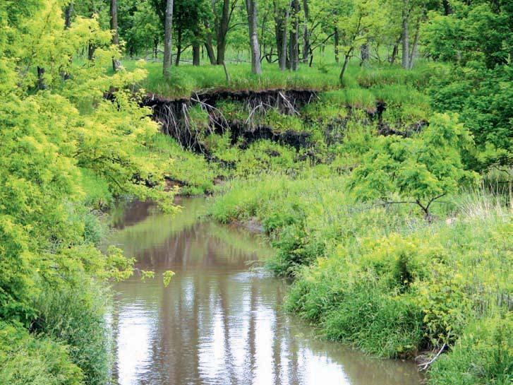
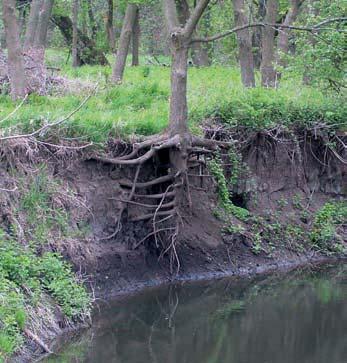
6 HOW TO CONTROL STREAMBANK EROSION To use this manual properly, one must have a basic understanding of why erosion is occurring, the physical and legal constraints in correcting the erosion problem, and the actions an individual can take to correct the problem. In many cases, the solution to the third problem may be to seek professional help in the design and installation of streambank erosion control measures. What is Streambank Erosion? Erosion is the removal of soil particles from a site due to the forces of water, wind, and ice. Over time, these forces will slowly wear away or disintegrate the soil. In the case of a stream, erosion may occur in several ways, identified below. Erosion of streams in agricultural areas normally occurs as a result of one of three factors: change in stream flow, water flowing over or through the streambank, and the discharge of concentrated runoff from other sources. Iowa s streams are subject to wide fluctuations in both flow depth and velocity over a period of years, due to normal seasonal changes in rainfall and large single-storm events. As flow depths and velocities increase, the force of the water flowing against the streambank removes soil particles from the banks, and in many cases erosion causes banks to slump and fall into the flowing water. In extreme situations where high flows persist over long periods, banks may erode several feet annually. Rain falling on streambanks or runoff from adjacent fields that enters a stream by flowing over the streambanks can also erode soil from streambanks, particularly if banks are inadequately protected. Finally, water discharged into a stream from tributary drainage systems (such as waterways or tile lines) can also erode streambanks, particularly if the water is discharged in an area where the bank is unstable and highly erodible. In many cases, moving the outlet to a point where the steam is less erodible or stabilizing the outlet area with rock can alleviate this problem. Although a stream channel may appear to be stable, when viewed over a period of decades or centuries most streams exhibit a tendency to adjust or shift location. In some instances, changes result from single events, such as a tree falling into a stream and deflecting the flow of the water. In other instances, these changes are due to differences in soil type and structure within the stream channel or are the result of erosion occurring from catastrophic storm events. Any straight stream channel will eventually erode on portions of each bank and begin to bend or meander. As the stream bends become longer and more sharply curved, more soil is eroded from one side of the channel and deposited on the other side of the channel. How to Control Streambank Erosion 2
7 Streambank Erosion Control Planning Considerations Erosion control projects should be planned carefully to achieve a successful result. The following factors should be considered before starting a streambank erosion project: Can erosion of the bank be reduced through conservation measures near the stream? In some cases, a landowner may be able to reduce bank erosion by using the following practices: o Farm no closer than feet from the edge of the streambank and establish permanent-type vegetation in this area identified as a buffer strip (see Riparian Buffers section). o Do not place excessive weight on the top of the bank in the 15-foot-wide strip nearest the stream. Do not make this a place for disposing of debris from the surrounding land or as a travel lane for vehicles or farm equipment. o Restrict or eliminate livestock access to the streambank or buffer zone. If possible, use off-stream watering sources to provide water to livestock. If this is not possible, restrict watering to specific locations where adequate streambank protection exists. o Remove fallen trees or other debris from the stream if debris is causing bank erosion problems. However, because trees often improve aquatic habitat conditions in streams, removal should be avoided when possible. o If seepage through the streambank is causing bank erosion, consider installing a subsurface drain system to intercept this drainage before it reaches the stream. Are nearby landowners also having problems with streambank erosion on this steam? If so, how have they dealt with the problems, and how can their successes or failures provide ideas about how to address specific problems? If other landowners are not experiencing problems, how are they managing the stream and adjacent lands differently, and would changing management practices solve the problem in question? Will the actions taken to solve a streambank erosion problem affect upstream or downstream landowners or public facilities such as roads or bridges? Any steps taken to solve a specific problem should be consistent with being a good neighbor and steward of the land. The entire stream should be considered as a system, and any project should consider impacts to the total system, not just on a single property. When will the site conditions be most suitable for carrying out the planned project, and how can construction activities be conducted to minimize stream impacts and maximize the safety of the individuals doing the work? Generally, construction activities should be planned for those periods of the year when stream flows are lowest. In some cases, certain activities may need to be carried out at other times of the year, particularly if the project involves planting trees or grasses. Can and should the work be carried out by the landowner or other private party, or does the project require specialized skills or equipment that should only be used by a qualified contractor? Working in or near a stream poses special safety How to Control Streambank Erosion 3
8 hazards, particularly if the stream has steep or high banks or the stream velocity is high. Where these conditions exist, using a contractor who has the needed equipment and experience is recommended. Are there permits and regulations that need to be obtained or considered before beginning? (see Permit Regulations section) How will this project affect the habitat of the fish and wildlife in and around the stream? Many of the methods covered in this manual can enhance habitat conditions within and adjacent to the stream. How much will the project cost, and will the benefits be sufficient to justify this cost? In many cases, the most severe streambank erosion problems occur on Iowa s larger streams. Unfortunately, due to the volume and velocity of the water carried in these streams, the cost of controlling erosion on these streams is also extremely high, and can generally only be justified if the erosion threatens a building, bridge, or other similar structure. Streambank Erosion Control Design and Construction Considerations Who will design the system and select the materials? For many of the methods illustrated in this manual, a professional engineer or person from the agencies listed above has the required specialized knowledge to design the system and can assist in the selection of the materials to be incorporated. Some of the materials identified in the manual are for use in specific restoration situations. Recommendations on alternative materials can be obtained through the Iowa DNR, NRCS, design consultants, LICA of Iowa, and through contractor supply companies in Iowa. When considering bioengineering materials, pay attention to materials readily available near the site or known to grow well along other streams in the area. Will the work be done by a contractor or by the landowner? The primary consideration in this decision is the safety of those working on the project. Consideration must be given to the velocity of the stream, depth of the stream at construction, slope and height of the bank, and the soils contained in the bank. 1. Stream velocity: Erosion can occur under any stream velocity, but becomes evident at velocities of greater than three feet per second. Velocities greater than three feet per second can pose safety concerns for workers as the depth of the stream increases. Erosion control work in areas with high water velocity requires special skills and equipment, usually only found with contractors. 2. Depth of stream: Depths of up to three feet allow individuals to work at the water s edge without special equipment. At depths in excess of three feet and velocities in excess of three feet per second, manual labor can become dangerous. Use of contractors should be considered for this type of work. 3. Bank slope: Slope is measured in terms of the horizontal distance from the top of the bank, toward the stream, for every one foot drop in elevation to the surface of the slope. Slopes of six feet horizontal to one foot vertical (6H: 1V) or flatter can be worked with landowner equipment, provided the total bank How to Control Streambank Erosion 4
9 height is less than four feet. Streambank protection activities on slopes steeper than 6H: 1V (ex. 1H: 1V to 5H: 1V) should only be conducted using specialized equipment, normally found with specialty contractors. 4. Bank height: The height is the difference in elevation between the top of the bank and the water at the low flow elevation. Property owners should only consider restoration of bank heights of less than four feet and with slopes as noted in item 3. Greater bank heights should be designed for restoration with a contractor s specialized equipment and knowledge. 5. Soils: Soil classifications for the materials present in the banks can be determined from the NRCS. Soil survey maps can be found in each Iowa DNR or NRCS office for the specific location ( This is the point where public agencies can help identify soils or other conditions that would be unsafe to operate motorized equipment over. 6. Volume of work to be accomplished in the streambank project: The property owner or developer must estimate the amount of time, materials, equipment, and labor necessary to complete the work as compared to those personally available. This is a subjective decision based on time, knowledge, and resource constraints. a. Construction activities should be conducted during periods of low flow. b. Construction equipment, activities, and materials should be kept out of the water to the maximum extent possible. c. All construction debris should be disposed of on land in such a manner that it cannot enter a waterway or wetland. d. Equipment for handling and conveying materials during construction should be operated to prevent dumping or spilling the material into water bodies, streams, or wetlands. e. Care should be taken to prevent any petroleum products, chemicals, or other deleterious materials from entering water bodies, streams, or wetlands. f. Clearing of vegetation, including trees located in or immediately adjacent to waters of the state, should be limited to that which is absolutely necessary for construction of the project. All vegetative clearing material shall be removed to an upland, non-wetland disposal site. Table 1 provides information that can be used to help select the streambank stabilization methods that are most appropriate for a given situation. Note that there may be several alternatives that meet the needs of a specific location. Each may be different in terms of types of materials used and cost of the design and installation. The property owner or developer must consider all of the criteria associated with the site and then employ the appropriate method. The decision may also involve considering successful operations done on adjacent portions of the streambank or considering ways to provide a certain aesthetic value to the area. How to Control Streambank Erosion 5
10 Table 1. Diagnosis of appropriate streambank stabilization methods Method Description Seeding of Planting of grasses on a streambank streambank to reinforce a bare streambank. Live Placement of woody plant and stakes tree cuttings on a graded bank to grow and stabilize the bank by the formation of roots and aboveground growth. Joint planting Combination of covering a streambank with rock and live stakes. Live fascine Placement of bundles of branches in trenches to slow over-bank erosion and establish structural soil stability. Combination of riprap, live fascine, live stakes, and brush to form a covering over the entire slope. Live cribwall Combination of timbers, live branches, soil, rocks, and logs to fill a bank and eventually establish a root network. Brushmattress Branchpacking Coconut fiber rolls Log, rootwad, and boulder revetment Tree revetment Dormant post planting Piling with wire or geotextile fencing Layering of live branch cuttings and compacted soil to fill small holes and slumps of a streambank. Cylindrical structures made of coconut husk fibers bound together with coconut husk twine. Logs are placed in the stream and held in place by boulders. The rootwads are then placed around the boulders to slow the flow of the stream, protect the bank, and provide habitats for fish and wildlife. *Bank erosion problem Stream velocity Stream depth Bank slope 1, ft/sec Any >6:1 1, 2, ft/sec & >3 ft/sec Any <6:1 Bank height <4 ft & >4 ft <4 ft & >4 ft Constr. cost Medium Maint. cost Low Medium Medium 2, 3, 4 >3 ft/sec Any <6:1 >4 ft High Low ft/sec Any >6:1 >4 ft High Low 1, 2, 4 >3 ft/sec Any <6:1 >4 ft High High 1, 2, 3 >3 ft/sec Any <6:1 >4 ft High Low 3 >3 ft/sec Any <6:1 >4 ft High High 1, 2, ft/sec 1, 3, 4 >3 ft/sec Any <6:1 Placement of trees along the eroding streambank. Placement of medium-sized trees in the slope next to the stream. 1, 2, 4 >3 ft/sec Any >6:1 Single or double row of pilings with mesh, wire, or geotextile on the streamside of the fence. Any >6:1 <4 ft Medium Medium <4 ft & >4 ft High Low 1, 3, 4 >3 ft/sec Any <6:1 >4 ft High Medium 1, 3, 4 >3 ft/sec Any <6:1 & >6:1 <4 ft & >4 ft >4 ft Medium Medium & High High Medium How to Control Streambank Erosion 6
11 Table 1. (continued) Method Description *Bank erosion problem Stream velocity Stream depth Bank slope Bank height Constr. cost Maint. cost Riprap Layer of various-sized rocks used <6:1 <4 ft & to protect a streambank from 1, 2, 3, 4 >3 ft/sec Any & >4 ft erosion. >6:1 High Low Jetty system Dike-like structure from the <6:1 streambank out into the streambed. 1, 3, 4 >3 ft/sec Any & >6:1 >4 ft High Low Iowa vanes Vanes placed in the eroding streambed that cause the flow to be redirected and result in the 1, 4 >3 ft/sec Any <6:1 & >4 ft Medium Low recollection of sediment on the bank. >6:1 Vegetated Combination of geotextiles, rock geogrids fills, and live materials. 1, 3, 4 >3 ft/sec Any <6:1 >4 ft High Low *Bank Erosion Problem: 1 = Fast flowing streams with erodible soils 3 = Fill structure for holes in streambank 2 = Extensive toe- and stream-level erosion 4 = Resistance to occasional heavy flows Streambank Erosion Control Maintenance Each of the methods described in this manual requires observation and maintenance of the streambank erosion control practices over time. Observations should be made on a regular basis prior to and after major stream flow events. Maintenance activities should include the following: 1. Removal of any debris that becomes entangled in the erosion control material and could damage the bank materials. 2. Replacement of missing or damaged erosion control materials during times of low stream flow. 3. Application of fertilizer to plant materials to enhance their growth each year. 4. Application of fertilizer and weed control to buffer strip vegetation. 5. Restriction of livestock from steep banks and the areas containing the erosion control measures. Riparian Buffers While completing an erosion control project, other factors can be considered to improve the water quality, riparian habitat, and the overall ecological health of the stream system. The use of riparian buffers is a popular method to increase the quality of water resources. The United States Department of Agriculture (USDA) offers an excellent booklet entitled Riparian Forest Buffers: Function and Design for Protection and Enhancement of Water Resources, which provides detailed information about the benefits and specifications of riparian buffers that will only be summarized here. How to Control Streambank Erosion 7
12 Refer to for the complete online booklet. The USDA defines a riparian forest buffer as An area of trees and other vegetation located in areas adjoining and up gradient from surface water bodies and designed to intercept surface runoff, wastewater, subsurface flow, and deeper groundwater flows from upland sources for the purpose of removing or buffering the effects of associated nutrients, sediment, organic matter, pesticides, or other pollutants prior to entry into surface waters and groundwater recharge areas. Specifically, riparian buffers provide the following benefits: Help cool the stream temperature, which improves insect and fish habitat. Establish complex root system from trees, shrubs, and grasses, which helps retain soil. Naturally removes phosphorous and nitrogen products from runoff water. Increases infiltration of water into the soil and slows the runoff. Decreases stream sediment load. Riparian buffers consist of three zones, a zone of stabilization at the stream edge, a tree and shrub area, and an area of dense grasses. Drainage tiles or pipes passing through riparian buffers should be minimized. Water that is normally carried through tiles or pipes should be allowed to flow through the buffer area to be naturally filtered and infiltrated and to allow for the removal of pollutants. The first zone next to the stream should be 15 feet wide, measured perpendicular to the stream. This zone can be comprised of the vegetation used in stream stabilization methods discussed in this manual. The second zone consists of an area with a minimum width of 60 feet, measured wide and on the land side of the first zone. It consists of trees, shrubs, and their litter of leaves and branches as an energy source to capture agricultural chemicals that pollute streams. Livestock should be restricted from zones one and two. Maintenance of zones one and two, especially after very high stream flows, is necessary. Zone three should be approximately 25 feet wide and contain natural grasses. This zone is an important area for infiltration of water during heavy storms. Livestock grazing over zone three should be limited to ensure adequate grass cover. The above description only outlines the minimum requirements and dimensions of a riparian buffer strip. Some riparian forest buffers can be up to 300 feet in width. More detailed information can be obtained from the Iowa DNR or the USDA Forest Service. How to Control Streambank Erosion 8
13 Permit Regulations Prior to beginning any streambank erosion control construction, the property owner should contact the Iowa DNR to determine the need for a special permit for the construction or use of special materials. Approval may be required from the DNR and the United States Army Corps of Engineers. The same application form is used for both agencies and can be obtained from the following: Iowa Department of Natural Resources Flood Plain Permits Section/Sovereign Land Section Wallace State Office Building 900 East Grand Avenue Des Moines, IA Telephone: (515) District Engineer U.S. Army Engineer District, Rock Island Regulatory Functions Branch Clock Tower Building Rock Island, IL Telephone: (309) The DNR typically has the following permit conditions for the types of materials used in the project: Riprap. It should consist of native field stone, quarry run rock, or clean broken concrete. If broken concrete is used, all reinforcement material shall be completely removed from it; if removal is not possible, the reinforcement material should be cut flush with the surface of the concrete. The riprap must be maintained free of exposed reinforcement material. The concrete pieces shall be appropriately graded and no piece shall be larger than three feet across the longest flat surface. No asphalt or petroleum-based material shall be used as or included in riprap material. Lumber. Wood products used in the construction of the project shall be limited to only water-based treated lumber; no creosote- or petroleum-treated lumber shall be permitted. How to Control Streambank Erosion 9

14 SEEDING OF STREAMBANK Establishing vegetation on streambanks is frequently the simplest way to stabilize the soil and slow erosion. Where erosion is not severe, the banks can be seeded with warm or cool season grasses and legumes. Live tree cuttings can be inserted in the ground to give greater bank protection over a longer period of time. Advantages and Disadvantages Seeding is useful when rich topsoil is readily available. Vegetation improves the appearance of streambanks. Seeding is low-cost, particularly when compared to structural erosion control methods. Seeding should be part of all projects, including those making use of more complex structural erosion control methods. If used alone, seeding may not be adequate to control bank erosion, especially when erosion is severe. Seeding must be done during low flow conditions, and vegetation must have sufficient time to grow before high flow conditions occur. If the bank is seeded shortly before a high flow event, the roots may not be strong enough to keep the plants and soil from washing away. Seeding is generally not suitable for stabilizing the toe of a streambank, as few plants will survive below water level. See the Willow-Post method for using trees to stabilize bank slopes at the edge of the waterline. Figure 1. Streambank that has been graded and seeded using a natural fiber blanket containing seed How to Control Streambank Erosion 10
15 Materials Seed mixture recommended by Iowa Department of Transportation: Alsike clover Fawn fescue Switchgrass Birdsfoot trefoil 5 lbs/acre 30 lbs/acre 10 lbs/acre 5 lbs/acre Preparation Regrade the slope no steeper than six feet horizontal to one foot vertical (6H: 1V). Always regrade by pulling dirt away from the stream to minimize the amount of soil discharged into the water. Check with the DNR prior to any flood plain disposal of spoil material resulting from the streambank grading. If the regraded bank does not contain adequate topsoil to support good vegetative growth, topsoil should be placed on the slope as needed. Additional bank stabilization can be obtained by installing a buffer strip of trees, shrubs, and grasses adjacent to the streambank. Installation There are several ways to apply the seed to the bank: A liquid seed mixture can be sprayed on the bank. The seeds can be evenly thrown on the bank and then covered with one-half inch of soil and lightly tamped to ensure contact with the soil. Straw or other suitable mulching material can also be used to provide initial bank stabilization and speed plant growth. Commercial seed mats can be used, giving more initial stabilization of the streambank (see Figure 1) and faster establishment. If increased vegetative growth is necessary, the slope can be treated with nitrogen in a 30-lb/acre application during the next growing season. How to Control Streambank Erosion 11

16 Figure 2. Seeded bank after a few months of growth How to Control Streambank Erosion 12
17 LIVE STAKES Live staking is the placement of woody plant and tree cuttings on a graded streambank to grow and stabilize the streambank by the formation of roots and aboveground brush. Advantages and Disadvantages To increase the resistance to erosion immediately after placement, erosion control fabric can be used to protect the slope and still allow the cuttings to grow. The natural formation of the interlocking roots secures the erosion control fabric and prevents gullies from forming. The roots and woody portion of trees, shrubs, and grasses slow the flow of water in high water stages. Staking a streambank helps dry out a wet, unstable bank and allows it to become more stable. This method is effective where there is an adequate supply of live cuttings and frequent heavy stream flows. Staking is also useful in conjunction with other more complex erosion control methods. This method should not be used if immediate stabilization is required. Materials Adequate supply of live stakes. Erosion control fabric. Saw, dead blow hammer, and iron bar or water jet. Preparation The streambank should be cut back to a two feet horizontal to one foot vertical (2H: 1V) or flatter slope. Check with the DNR prior to any flood plain disposal of spoil material resulting from the streambank grading. The cuttings should be o Cut with a saw or machete, not an ax, and the side branches should be removed. o Between one-half to two inches in diameter. o Between two to three feet in length. o Note: Bark should not be damaged during installation. How to Control Streambank Erosion 13


18 Figure 3. Live stake preparation Figure 4. Growing a live stake Installation Trees that can be used: o Young willows o Shrub dogwoods o Species with long straight branches and that root easily Cuttings should be installed the same day they are cut. Live stakes should be installed during the dormant season (October March). How to Control Streambank Erosion 14

19 The stake should be oriented with the buds pointed up, and the bottom should be cut at an angle for easy insertion into the ground. A dead blow hammer should be used to tamp all stakes. The stakes should be tamped into the ground perpendicular to the slope. About four-fifths of the length of the stake should be below ground and angled downstream. An iron bar can be used to make a pilot hole to prevent bark from being damaged during installation. The stakes should be randomly placed with two to four stakes per square yard. A list of woody plants native to Iowa and their rooting properties is included in Appendix A. Figure 5. Live stake installation How to Control Streambank Erosion 15

20 JOINT PLANTING Joint planting is a combination of covering a streambank with rock and live stakes. Advantages and Disadvantages The riprap aggregate can be used to reinforce the toe of the slope below the stream. The roots from the live stakes establish a root mat below the rock to prevent the erosion of fine particles below and between the rocks. Erosion control fabric can also be used underneath the rocks to prevent soil loss. This method is very effective where riprap is required or already being used. Live stakes establish the natural look of the slope. The live stakes growth over the stream improves aquatic habitats in the cooler water due to the shade. Materials There must be a supply of live cuttings in the area and a source of riprap (see Riprap section on page 9). Figure 6. Joint planting system installation How to Control Streambank Erosion 16

21 Preparation The streambank should be shaped to a slope of two feet horizontal to one foot vertical (2H: 1V) or flatter. Check with the DNR prior to any flood plain disposal of spoil material resulting from the streambank grading. The stakes are prepared as they are in live staking. The stakes should have a minimum diameter of 1.5 inches. Figure 7. Joint planting details Installation Riprap should be mechanically or hand placed across the full height of the bank to ensure a uniform distribution of rock particle sizes across the disturbed area. Stakes can be placed randomly between the rock (two to four stakes per square yard) during or after the installation of the rock. The bottom ends of each cutting should extend well into the soil and protrude slightly from the rock. Buds should be placed upward when planted and the cutting should be undamaged. How to Control Streambank Erosion 17
22 LIVE FASCINE Live fascine is the placement of bundles of branches in trenches on the streambank to reduce erosion across the bank and establish soil stability. Advantages and Disadvantages Live fascine is most effective when combined with live staking and riprap. The fascine is placed above the stream-forming flow and causes minimal site disturbance. A tiered streambank creates shorter slopes to slow overland flow. Angled fascines create drainage paths in the slope. Successful fascines require a large supply of long branches. Materials Adequate supply of long branches. Rock for riprap (see Riprap section on page 9). Twine. Shovel. Live stakes and untreated lumber stakes. Preparation The streambank should be at least a two feet horizontal to one foot vertical (2H: 1V) slope, or tiered with three- to five-foot steps. Long, straight bundles of native branches should be prepared in six- to eight-inch diameter bundles, bound with untreated twine. The bundles should be from five to ten feet in length. Within the bundles, all of the growing tips should be oriented the same direction. A supply of live stakes and dead stout stakes should be prepared in 2.5-foot lengths. The dead stout stakes should be made of untreated lumber. How to Control Streambank Erosion 18


23 Figure 8. Live fascine placement Figure 9. Live fascine stake network How to Control Streambank Erosion 19

24 Figure 10. Live fascine details Installation Excavate trench(es) on the slope. Place erosion control fabric in and between the trenches (see Figure 10). Place fascines in the trench(es). Drive dead stout stakes directly through the fascine every two to three feet, flush with the top of the fascines and at the connections of bundles. Drive live stakes between dead stout stakes, with three inches above the fascine. Place moist soil alongside of the fascine, but allow the top of the fascine to be seen. Riprap can be used to stabilize the toe of the slope, prevent it from being scoured, and secure the erosion control fabric. How to Control Streambank Erosion 20

25 BRUSHMATTRESS Brushmattresses are a combination of riprap, live fascine, live stakes, and brush to form a covering over the entire slope. Advantages and Disadvantages A brushmattress provides immediate protection from streambank erosion and can be used along fast-flowing streams. Brush and fascines restore vegetation and habitats to the bank, giving the soil below the brush stability from the formation of a root mat and cover of the brush. Riprap can be used to stabilize the toe of the slope, and a live fascine can be placed just above the riprap. Brush is then used to cover the slope and is held in place by live and dead stakes and wire. Figure 11. A brushmattress with riprap at the toe of the slope Materials Branches six to nine feet in length and one inch in diameter. Live stakes (see Live Stake section). Live fascine (see Live Fascine section). Wire mesh to secure branches. Dead stout stakes to secure brush and live fascine. How to Control Streambank Erosion 21
26 Preparation The streambank should be graded to a maximum slope of two feet horizontal to one foot vertical (2H: 1V). Check with the DNR prior to any flood plain disposal of spoil material resulting from the streambank grading. Live fascines and stakes should be prepared just prior to installation in the streambank. Dig a trench that adequately contains the live fascines. Installation After the slope has been graded, place the live fascine in a trench at the base of the slope. See Live Fascine section for detailed installation. Place live and dead stakes at a one-foot depth in the graded slope at a spacing of two square feet per stake. Place branches, with basal ends located in the trench of the fascine, in a layer one to two branches thick. Stretch wire mesh over the branches and tie the ends to the live and dead stakes to secure the branches. Riprap can also be placed at the toe and down into the streambed. How to Control Streambank Erosion 22
27 LIVE CRIBWALL Live cribwall is a structure made of live materials to reconstruct the streambank where extreme erosion has occurred. A combination of timbers, live branches, soil, rocks, and logs are used to rebuild a bank and eventually establish a root network. The roots will eventually take over the structural purpose of the timbers. A live cribwall is best used on the outside bend of a stream because the strongest currents act on this side of the stream. Advantages and Disadvantages The structure can be filled to form a vertical wall. A live cribwall requires minimal space. Stability above and below the water level is provided. The toe of the slope is stabilized. Live cribwalls can provide a natural habitat for riparian wildlife. Immediate sloe protection is provided. A large amount of material and labor is required. The design is complex. The height of the cribwall should not exceed 7 feet. The width of cribwall should not exceed 20 feet. Materials Live branch cuttings, 0.5 to 2.5 inches in diameter and long enough to reach from the front to the back of the structure. Logs and untreated timbers 4 to 6 feet in length. Steel reinforcing bars. Preparation Excavate 2 to 3 feet below the base of the streambed to a stable foundation 5 to 6 feet wide. Excavate the back of the trench (furthest from the stream) 6 to 12 inches lower than the front to add stability. Check with the DNR prior to any flood plain disposal of spoil material resulting from the streambank grading. How to Control Streambank Erosion 23
 or nails at each crossing point.")
28 Installation Place logs or timber layers in alternating directions (at right angles to the previous layer) to form a box shape. Fasten the layers of logs or timbers together using rebar (rebar will need to be inspected periodically to ensure it is not exposed) or nails at each crossing point. Each layer of logs should be placed to make a box-like structure. Place rock fill in the bottom of the crib structure, up to the level of the streambed, and in front of the structure for added toe support, especially if the structure is used on the outside bend of the stream. Place the branches with the growing tips towards the stream and the basal ends in contact with the back of the trench. After each layer of branches, place a layer of compacted soil. To ensure success, the upstream and downstream sections should be well-secured to the bank to prevent undercutting. Figure 12. Live cribwall details How to Control Streambank Erosion 24
. The branches root and stabilize the soil to the bank.")
29 BRANCHPACKING Branchpacking is the layering of live branch cuttings and compacted soil to fill small holes and slumps in a streambank. Figure 13. Active branch packing system Advantages and Disadvantages Branchpacking is used to fill holes or gullies (two to four feet in height and depth). The branches root and stabilize the soil to the bank. An immediate barrier is provided to reinforce the bank and prevent bank erosion from overland flow. Branchpacking is an effective and inexpensive method on small projects. Natural vegetation is established. Branchpacking should not be used on an eroded bank with holes greater than four feet in depth and four feet in width. Branchpacking should be established flush with the existing bank to prevent scouring. Branches need to be long enough to reach from the face of the existing bank to the back of the fill or gully. Materials Rootable live cuttings, one-half to two inches in diameter and three to five feet long. Stakes five to eight feet long and three to four inches in diameter or two- by fourinch lumber. Adequate supply of backfill to fill the area. How to Control Streambank Erosion 25
30 Preparation Clean out the bottom of the hole to ensure a good foundation. Slope the bottom of the hole towards the rear of the bank. Use rock to stabilize the toe of the fill. Figure 14. Active branch packing installation Installation Drive stakes vertically three to four feet deep into the ground and about one foot apart. Combine the first layer of branches with some rock. Compact the soil above the first layer. Repeat with branches and compacted soil. Place the basal ends of the branches lower than the growing tips and against the back of the hole. Continue layering the branches and stakes up until the level of the existing streambank. How to Control Streambank Erosion 26

31 COCONUT FIBER ROLLS Coconut fiber rolls are cylindrical structures made of coconut husk fibers bound together with coconut husk twine. The roll is staked to the toe of the slope. Rolls are about 12 inches in diameter and up to 20 feet long. Figure 15. Coconut roll staked to bank with coconut fiber fabric across slope to protect exposed soil Advantages and Disadvantages Shallow earth slips are prevented. Undermining at the toe of a streambank is prevented. Plants can grow in the roll. A flexible roll allows the roll to conform to the bank. Disturbance to the streambank is limited. Sediment is trapped in the fibers. The roll provides erosion control for 6 to 10 years. The materials are relatively expensive. Materials Coconut fiber rolls long enough to cover the area of reinforcement. Stakes to hold the roll to the streambank. How to Control Streambank Erosion 27

32 Preparation Dig a trench at the toe of the slope to a depth slightly below the base flow elevation of the stream. Prepare stakes that are 2 by 2 by 36 inches (see Figure 16). Installation Place the coconut roll in the trench, but not at a depth where stream is above the roll. Place stakes through the coconut roll on both sides of the roll about every 2 to 4 feet. A stream with fast-flowing water will need more stakes to hold the roll to the bank. Use vegetation to stabilize the rest of the streambank. Figure 16. Installation of stakes to secure a coconut roll How to Control Streambank Erosion 28

33 DORMANT POST PLANTINGS Dormant post plantings and the willow post method are very similar methods of bank stabilization, in which medium-sized trees are placed in the slope next to the stream. The dormant posts are placed in rows adjacent to the stream and form a permeable barrier. Advantages and Disadvantages Vegetation is established on the streambank. Dormant post planting slows the stream, especially in high water flows, and catches sediment. Dormant post planting is best used on small, non-gravel streams. Dormant post planting can be damaged by ice flows. Some heavy equipment is required to install the stabilization. The moisture of the slope is reduced by the roots of the trees. Materials Native species of trees that root well and are locally available. Posts seven to nine feet long and three to five inches in diameter. Figure 17. Willow posts on a streambank How to Control Streambank Erosion 29
34 Preparation Taper the bottom of the posts to insert the posts easily. Install the posts by using water jetting, mechanized stingers, or a machine ram. Installation Begin installing the posts at or above the normal waterline pointing upwards with one-half to two-thirds of the length of the post driven into the ground. The bottom twelve inches of the post should be in saturated soil to insure adequate moisture for growth. The posts should be placed in rows in either a square or triangular pattern. It is recommended that soil bioengineering techniques be used above the posts. How to Control Streambank Erosion 30
35 PILINGS WITH WIRE OR GEOTEXTILE FENCING Pilings with wire or geotextile fencing are single or double rows of pilings with wire mesh, wire, or geotextile on the streamside of the fence. The pilings are driven parallel to the streambank, and the mesh, wire, or geotextile slow the flow of water through the fence. By slowing the speed of the water, the bank is protected from the force of fastflowing water. Pilings with slotted fencing are a single or double row of pilings with planks between the posts instead of wire fencing. The slotted fencing makes a slightly sturdier structure than the wire fencing. The space between the bank and fence or between the two fences can be filled with brush and trees as well. Figure 18. Piling revetment details Advantages and Disadvantages The stream needs to be at least three feet deep. Pilings work well in deeper streams, but should not be used when the piling length exceeds nine feet. Pilings can be damaged by ice and debris flows. Pilings are not recommended to maintain or enhance riparian wildlife habitat. How to Control Streambank Erosion 31
, or pipe (materials should not be toxic). Obtain woven wire or geotextile fabric.")
36 Materials Eight- to twelve-inch-diameter wood with a length equal to twice the bank height at the point of entry. Heavy woven wire or geotextile fabric. Preparation Select several pilings made from timbers, logs (see Lumber section on page 9), or pipe (materials should not be toxic). Obtain woven wire or geotextile fabric. Obtain or rent equipment capable of driving the selected piling materials in the stream bed. Select rock and brush for the space between a double row of pilings. Clear the stream bottom of debris along the alignment of the wire fencing to allow for its installation. Installation Drive pilings six to eight feet apart with half of the length of the piling driven into the deepest part of the eroding streambed. If a double row of fencing is being created, the second row is placed five feet up the slope from the first row. Attach the wire, mesh, or geotextile fabric to the streamside of the pilings. If a double row of pilings is used, fill the space between the two rows with rock and brush. Figure 19. Diagram of wire fencing between posts How to Control Streambank Erosion 32

37 RIPRAP Riprap is a layer of various-sized rocks used to protect a streambank from erosion. Figure 20. Riprap along the bend of a stream with vegetation between the rocks Advantages and Disadvantages Riprap is effective because the rock can adjust to the contours of the streambank and vegetation can grow among the rocks to provide habitat for wildlife in and above the stream. Riprap is easy to install and repair, has a natural appearance, and does not harm the environment. Riprap works well with a combination of soil bioengineering techniques used up the slope. Materials Class D or E revetment stone, preferably broken limestone, dolomite, or quartzite, available from most quarries (see the Riprap section on page 9). Rough, angular surfaces and variety of sizes will allow the rock to fit together tightly to form a dense barrier. Preparation Determine the stream s velocity by dropping a wood chip into the stream and counting the number of seconds it takes for the chip to travel 50 feet. Divide 50 How to Control Streambank Erosion 33
38 by the number of seconds to get the stream s velocity in feet per second. Table 2 describes the sizes for riprap based on the speed at which water flows when the stream is at high-flow conditions. Table 2. Recommended sizes for riprap Velocity of stream during high flow Size range (diameter across longest part of rock) Slow (2-4 ft/sec) 3" - 6"; average 4" Moderate (4-6 ft/sec) 4" - 12"; average 8" * Fast (6-12 ft/sec) 5" - 18"; average 14" *This velocity is the most common cause of streambank erosion in Iowa. Use a rock size that the velocity of the stream will not be able to move when the stream is at high-flow conditions. The rock used for riprap on fast-flowing streams should weigh between 5ive and 150 lbs, with most of the stones weighing at least 90 pounds. Smaller rocks should be included in the mixture to fill in the spaces between the larger rocks. Broken concrete can be used if the pieces vary in size (well-graded) and the steel reinforcement rods have been removed. Broken asphalt should not be used, because of its toxicity to riparian wildlife and low density. Rubble from the demolition of buildings should not be used if it contains wood, wallboard, plaster, etc. Junk such as washing machines, cars, tires, and refrigerators should never be used. In many cases, junk littering a streambank aggravates the erosion problem. Before installing riprap, the bank should be reshaped to a maximum slope of 2 feet horizontal to 1 foot vertical (2H:1V) or flatter. Installation A geotextile fabric can be used after the slope has been graded to stabilize the soil. Place a 6-inch layer of gravel or crushed stone, and then firmly place the riprap. If a properly chosen filter/engineering fabric is used, gravel or crushed rock does not need to be used. The rock should be inspected to ensure a variation of rock size throughout the slope, and the largest, heaviest rocks should be placed along the bottom of the bank. The rocks should form a layer 12 to 18 inches thick. The rock should generally cover the bank from the bottom of the stream to the level of a 2-year or 5-year storm. The remainder of the eroding bank should be reshaped and planted with trees, shrubs, and grasses, as described in the previous sections of this document entitled Seeding of Streambank and Live Stakes. If streambed scouring is anticipated, extend the riprap into a trench across the streambed so that if the current makes the channel deeper, the riprap barrier will not be undermined. Use this approach only where streambed degradation is How to Control Streambank Erosion 34
39 present. This process may require a series of such stream crossings in the same area to reduce the stream velocity through the area of potential bank erosion. Existing vegetation, plantings or soil bioengineering systems Top of riprap minimum thickness = maximum rock size Depth below streambed - minimum of 2x maximum rock size Figure 21. Cross-sectional view of riprap placement on the graded slope of a streambank How to Control Streambank Erosion 35

40 JETTY SYSTEM A jetty system is a dike-like structure extending from the streambank out into the streambed. The dike or jetty protects the bank from erosion. Figure 22. Stream jetty placement for bridge protection Advantages and Disadvantages A jetty system can be used on various sizes of streams. A jetty system is an effective method of controlling erosion on bends. Jetties should be used with soil bioengineering upstream of the jetties, where sediment will be deposited. Professional design of the configuration and placement of each jetty is required. Materials and design can cause the jetty to be complex and expensive. Materials Rock (see the Riprap section on page 9 and the previous section). Preparation The rock size should be selected so that it will not be washed away when bankfull flow occurs. Before placing the jetties, the layout of the jetties should be determined. How to Control Streambank Erosion 36

41 The length of each jetty should not exceed 25% of the width of the stream. Exceeding 25% of the stream width will encourage erosion of the opposite bank. The jetty should be spaced equal to 2 to 5 times the length of the jetty. Installation Each jetty should be securely anchored into the bank and the bed to prevent washout or the stream from cutting around the jetty. The height of the jetty should be the height of the bank. The width of each jetty should be 8 to 12 feet. The sides of the jetty should have a 2-foot-horizontal to 1-foot-vertical (2H:1V) slope. Figure 23. Stream jetty details How to Control Streambank Erosion 37
42 IOWA VANES Iowa vanes are structures placed in an eroding streambed that cause the flow to be redirected, which results in the deposition of sediment on the eroding bank. When erosion occurs in the bend of a stream, the outside bank is significantly undermined by the flow from the straight portion of the stream colliding with the bank. The outside edge of the streambed is deepened as the bank erodes, but vanes stabilize the stream without affecting the sediment load and velocity of other parts of the stream. Advantages and Disadvantages The toe of the bank is stabilized. Soil bioengineering should be used with the vanes to stabilize the bank. Once the sediment has been deposited at the bank, natural revegetation often occurs. The area of the channel or the sediment load upstream or downstream is not changed significantly. Iowa vanes are impractical for use in a narrow stream channel; the channel should be 15 to 20 feet wide. The vane system requires professional design. Iowa vanes should only be used in a sand bed channel. Vanes can tolerate ice flows and other debris because they are often submerged below the surface of the water. Vanes can cause damage to boats. Therefore, they should be clearly labeled with signs and buoys. Various types of materials can be used to create a submerged vane. Materials Purchased, preformed Iowa vanes. Planks and pipe to construct vanes. Crane to lower prefabricated vanes into the water. Ram or hammer to drive the pipe into the streambed. Preparation The simplest way to construct a stable vane is to use two metal tubes or pipes driven securely into the streambed. The pipes should be 6 to 9 feet apart and angled 20 to 25 toward the bank to establish the alignment of the vane against the stream. Planks should then be fastened between the tubes. Use the water surface as a reference point to level the planks. The length of each vane should be between 6 and 9 feet long. The height of each vane should be about 1 foot above average bed level or between 2 and 3 feet. How to Control Streambank Erosion 38

43 Each vane should be no less than 1 to 3 inches in thickness at the top of the vane. Each vane should be completely submerged in average flow. Figure 24. Installation of concrete Iowa vanes at low flow Installation Installation of the vanes should begin at least one channel-width upstream from the bend where erosion is occurring. An array is a group of vanes next to each other; there should be 2 to 3 vanes in each array and at least three arrays before the area needing protection. The vanes within an array should be spaced 2 to 3 times the height of the vane. Between each array, there should be a distance of 15 to 30 times the height of a vane. The most upstream arrays can have a smaller amount of space between them, while those further downstream should have a greater distance between them, but not exceeding 30 times the height of the vane. Vanes do not need to be installed past the bend where erosion is occurring. How to Control Streambank Erosion 39
44 Cross-section view of stream channel Average flow level 2-3 H Average bed level H Degrading bed on outside of bend H = Height of vane used as a reference length for orientation of vane. Plan view of stream channel 4H 15-30H Portion of bank being eroded Figure 25. Iowa Vane placement details How to Control Streambank Erosion 40

45 Figure 26. Replacement of sediment on bank from Vanes How to Control Streambank Erosion 41

46 VEGETATED GEOGRIDS Vegetated geogrids are the covering of soil with erosion control fabric (geotextile) on the slope of the bank. The erosion control fabric is secured by tucking it into the slope. Live cuttings are placed between the geogrids, and a root structure is established to bind the soil within and behind the geogrids. The toe of the bank is stabilized by layers of rock on top of the same geotextile fabric. Advantages and Disadvantages Vegetated geogrids can be used where the bank cannot be pulled back to a gentle slope. Vegetated geogrids can be used where a bank has severely eroded. A large amount of soil and rock must be available to fill against the bank. Rapid vegetation growth is allowed from the live cuttings, which slows water during high water stages. Figure 27. Vegetated geogrid details How to Control Streambank Erosion 42


47 Figure 28. Completed geogrid installation Figure 29. Vegetated geogrid two years after installation Materials Branches 0.5 to 2.5 inches in diameter to reach to the existing bank. Rock fill with a diameter of 4 to 9 inches. Geotextile fabric/erosion control fabric. How to Control Streambank Erosion 43
Biotechnical streambank stabilization
 Traditional streambank stabilization Biotechnical streambank stabilization Channelization alters: shape pattern slope bed morphology cover Ecological effects: loss of riparian habitat loss of fish habitat
VEGETATED SLOPE STABILIZATION DESCRIPTION APPLICABILITY. Advantages
 4.2-d VEGETATED SLOPE STABILIZATION Alternative Names: Willow Wattles, Live Bundles, Fascines, Live Staking, Joint Planting, Branch Packing, Brush Layering, and Brush Matting DESCRIPTION Vegetated slope
STREAM ALTERATION PRACTICES
 STREAM ALTERATION PRACTICES Stream Diversion Channel SDC DEFINITION A temporary channel constructed to convey stream flow around in-stream construction. PURPOSE Stream diversion channels are used to allow
Department of Agriculture. Conservation Service. United States. Natural Resources REVISED 8/26/16
 GENERAL NOTES: SYMBOL LEGEND 1. All work shall comply with the constriction specifications, drawings, project-specific quality assurance plan and other contract requirements. 2. All notes on the drawings
Bio-Engineering Techniques to Revegetate Streambanks
 Bio-Engineering Techniques to Revegetate Streambanks DORMANT CUTTINGS Dormant cuttings are harvested from living woody plants. The cuttings are prepared from branches of woody plants when the plant is
PERMANENT SEEDING. Overview of Sedimentation and Erosion Control Practices. Practice no. 6.11
 Overview of Sedimentation and Erosion Control Practices Practice no. 6.11 PERMANENT SEEDING Permanent vegetation controls erosion by physically protecting a bare soil surface from raindrop impact, flowing
Town of Essex Small Site Erosion Control Guide
 Town of Essex Small Site Erosion Control Guide Why do we need to protect against erosion? Water Quality: Erosion and the transport of sediment and pollutants impacts the water quality of nearby streams
DITCH BANK STABILIZATION TECHNIQUES
 onstructed Ditch Drainage anagement Guide - No. 0 in series Order No. 5.0- December 00 DITH BANK STABILIZATION TEHNIQUES It is important to maintain ditches using practices that ensure ditch banks remain
Urban Conservation Practice Physical Effects ESTABLISHMENT, GROWTH, AND HARVEST NUTRIENT MANAGEMENT
 NOT WELL 800 - Urban Stormwater Wetlands A constructed system of shallow pools that create growing conditions for wetland plants to lessen the impacts of stormwater quality and quantity in urban areas.
Guidelines for Streambank Protection
 PDHonline Course C187 (3 PDH) Guidelines for Streambank Protection Instructor: John Poullain, PE 2012 PDH Online PDH Center 5272 Meadow Estates Drive Fairfax, VA 22030-6658 Phone & Fax: 703-988-0088 www.pdhonline.org
Banking on Natural Fibers Products made from coir and jute play a key role in stabilizing a restored stream for a commercial stream mitigation bank.
 Banking on Natural Fibers Products made from coir and jute play a key role in stabilizing a restored stream for a commercial stream mitigation bank. By Greg Northcutt When White Creek Mitigation, LLC,
Stream Bank Erosion: Soil Bioengineering Solutions
 Stream Bank Erosion: Soil Bioengineering Solutions The principal causes of streambank erosion can be classed as geologic, climatic, vegetative, and hydraulic. These causes may act independently, but normally
HYDRAULIC DESIGN involves several basic
 Chapter 6 Tools for Hydr draulic and Road Design HYDRAULIC DESIGN involves several basic concepts that must be considered to build successful projects with a minimum risk of failure (Photo 6.1). Use of
SECTION 6. Routine Maintenance Activity Details
 SECTION 6 Routine Maintenance Activity Details 80. DEBRIS REMOVAL When Deadfall, and other objects, such as shopping carts, tires, appliances, and mattresses have accumulated in the drain. Why To prevent
RAIN GARDEN ILLINOIS URBAN MANUAL PRACTICE STANDARD. (feet) CODE 897 DEFINITION
 CODE 897 DEFINITION") ILLINOIS URBAN MANUAL PRACTICE STANDARD RAIN GARDEN (feet) CODE 897 Source: Kendall County Soil and Water Conservation District DEFINITION Rain gardens are small, shallow, flat bottomed depressions constructed
ILLINOIS URBAN MANUAL PRACTICE STANDARD RAIN GARDEN (feet) CODE 897 Source: Kendall County Soil and Water Conservation District DEFINITION Rain gardens are small, shallow, flat bottomed depressions constructed
EROSION & SEDIMENT CONTROL
 EROSION & SEDIMENT CONTROL 1 EROSION & SEDIMENT CONTROL Effective Soil & Water Protection Whether you want to prevent soil erosion caused by rain, water and wind, or protect waterways from inevitable build
CHAPTER 5. Soil Bioengineering Techniques
 CHAPTER 5 Soil Bioengineering Techniques Soil bioengineering is an applied science that combines the use of engineering design principles with biological and ecological concepts to construct and assure
Wisconsin NRCS Direct Volume Method Bank Recession Rate Categorizations
 2 Executive Summary The City of Ramsey contracted the Anoka Conservation District to complete an inventory of riverbank condition along the entire 5.8 miles of City that border the Mississippi River. The
Soil bioengineering and ecological
 Soil bioengineering and ecological systems Techniques Click to proceed... Copyright 2001 Maccaferri Inc. All rights reserved. All reproduction, including photocopy, film and microfilm, is forbidden. Release
Working with nature to manage your stream
 Working with nature to manage your stream Issued by Auckland Council March 2013 If you have any questions about this information sheet please contact Auckland Council on 09 301 0101 A stream in a property
USING PLANTS TO STABILIZE STREAM BANKS
 USING PLANTS TO STABILIZE STREAM BANKS This handout is intended to provide you with a general orientation to the three most common and practicable soil-bioengineering techniques. In a number of situations,
Erosion Control for Home Builders in the. City of Jacksonville
 Erosion Control for Home Builders in the City of Jacksonville Eroding construction sites are a leading cause of water quality problems in Jacksonville. For every acre under construction, about a dump truck
Vegetating Disturbed Road & Stream Banks. By Mike Fournier NRCS Resource Conservationist
 Vegetating Disturbed Road & Stream Banks By Mike Fournier NRCS Resource Conservationist Clearly Identify The Problem Project Objectives Clearly Define Objectives Before Work Starts Determine Whether Project
Low Gradient Velocity Control Short Term Steep Gradient [1] Channel Lining Medium-Long Term Outlet Control Soil Treatment Permanent
![Low Gradient Velocity Control Short Term Steep Gradient [1] Channel Lining Medium-Long Term Outlet Control Soil Treatment Permanent](/thumbs/77/74849271.jpg "Low Gradient Velocity Control Short Term Steep Gradient [1] Channel Lining Medium-Long Term Outlet Control Soil Treatment Permanent") Grass Linings DRAINAGE CONTROL TECHNIQUE Low Gradient Velocity Control Short Term Steep Gradient [1] Channel Lining Medium-Long Term Outlet Control Soil Treatment Permanent [1] May be used on short, steep
Grass Linings DRAINAGE CONTROL TECHNIQUE Low Gradient Velocity Control Short Term Steep Gradient [1] Channel Lining Medium-Long Term Outlet Control Soil Treatment Permanent [1] May be used on short, steep
General Information. Site Conditions. 9b 9b. 9a 1b. Best Management Practices Illustration
 Model Construction SWPPP Planning & Development Services 1800 Continental Place Mount Vernon WA 98273 voice 360-416-1320 inspections 360-416-1330 www.skagitcounty.net/stormwaterpermitting Permit #: General
Streambank Protection (SP)
") Streambank Protection (SP) Practice Description Streambank protection is the stabilization of the side slopes of a stream. Streambank protection can be vegetative, structural, or a combined method (bioengineering)
Streambank Protection (SP) Practice Description Streambank protection is the stabilization of the side slopes of a stream. Streambank protection can be vegetative, structural, or a combined method (bioengineering)
Use of Best Management Practices
 Use of Best Management Practices Presented at the ANJEC Flood Hazard Workshop Bordentown, NJ March 13, 2008 Stormwater BMPs "a technique, measure or structural control that is used for a given set of conditions
EROSION & SEDIMENT CONTROL
 EROSION & SEDIMENT CONTROL Surface Water Protection During Well Site Construction Kelly Kees, PE WVDEP, Office of Oil and Gas SEDIMENT & EROSION CONTROL PLANS Per West Virginia State Code 22-6-6(d) 22-6A-7(c),
Stormwater and Your Rain Garden
 Stormwater and Your Rain Garden When rain falls on natural areas, such as a forest or meadow, it is slowed down, filtered by soil and plants, and allowed to soak back into the ground. When rain falls on
Coir Block System (fabric attached coir block) add New Dimension to Streambank Stabilization Projects
 add New Dimension to Streambank Stabilization Projects") Coir Block System (fabric attached coir block) add New Dimension to Streambank Stabilization Projects Using geotextiles to confine soil in lifts between layers of live plants has become an increasingly
Coir Block System (fabric attached coir block) add New Dimension to Streambank Stabilization Projects Using geotextiles to confine soil in lifts between layers of live plants has become an increasingly
Rain Gardens. A Welcome Addition to Your Landscape
 Rain Gardens A Welcome Addition to Your Landscape Where Does The Rainwater Go? Naturally, forests provide a way for rainwater to percolate into the soil, filtering pollutants while trees are allowed to
Alternative Names: Erosion Control Matting, Erosion Control Netting, Rolled Erosion Control Products (RECP)
") 4.5-s EROSION CONTROL BLANKET SYSTEM Alternative Names: Erosion Control Matting, Erosion Control Netting, Rolled Erosion Control Products (RECP) DESCRIPTION Erosion control blanket systems are woven or
4.5-s EROSION CONTROL BLANKET SYSTEM Alternative Names: Erosion Control Matting, Erosion Control Netting, Rolled Erosion Control Products (RECP) DESCRIPTION Erosion control blanket systems are woven or
SECTION SOIL BIOENGINEERING OR SHORELINE STABILIZATION
 SECTION 32 93 43 SOIL BIOENGINEERING OR SHORELINE STABILIZATION PART 1 GENERAL 1.01 SECTION INCLUDES A. CONTRACTOR shall furnish all labor, materials, supplies, equipment, tools and transportation; perform
Part IV(a): BMPs for Erosion, Sediment, Velocity Control
: BMPs for Erosion, Sediment, Velocity Control") Part IV(a): BMPs for Erosion, Sediment, Velocity Control Find Design Standards and Specifications for Iowa Erosion and Sediment Control Practices at: www.iowasudas.org Erosion Control Keeping the soil
Part IV(a): BMPs for Erosion, Sediment, Velocity Control Find Design Standards and Specifications for Iowa Erosion and Sediment Control Practices at: www.iowasudas.org Erosion Control Keeping the soil
Structural Storm Water Best Management Practices (BMPs)
") Structural Storm Water Best Management Practices (BMPs) Storm Water Permitting: The SWPPP Revealed By Deron Austin, PE January 11, 2006 3:30-5:00 PM Orlando, Florida Presentation Outline Preface About
Structural Storm Water Best Management Practices (BMPs) Storm Water Permitting: The SWPPP Revealed By Deron Austin, PE January 11, 2006 3:30-5:00 PM Orlando, Florida Presentation Outline Preface About
Tips for Maintaining and Enhancing Stormwater Management Areas
 4 4 N. Second Street, Denton, Md. 21629 (410) 479-3625 (410) 479-3534 fax www.dentonmaryland.com Tips for Maintaining and Enhancing Stormwater Management Areas Information provided by the Town of Denton
THE OBJECTIVES OF ROUTINE ROAD CUTS AND FILLS
 Chapter 11 Slope Stabiliza bilization and Stability of Cuts and Fills THE OBJECTIVES OF ROUTINE ROAD CUTS AND FILLS are 1) to create space for the road template and driving surface; 2) to balance material
RIVER TRAINING STRUCTURES
 RIVER TRAINING STRUCTURES SPUR DIKES Spur dikes, deflectors or groins are transverse structures that extend into the stream from the bank and reduce erosion by deflecting flows away from the bank. Transverse
Vegetated Filter Strips and Buffers
 3.15 Sediment Control Description: Buffer strips (existing vegetation) and filter strips (planted vegetation) are sections of vegetated land adjacent to disturbed areas. They are designed with low slopes
5.0 Storm Water Landscape Guidance Introduction
 5.0 Storm Water Landscape Guidance Introduction Landscaping is a critical element to improve both the function and appearance of storm water management practices. Integrated storm water landscapes can
Bowling Green, Kentucky Stormwater Best Management Practices (BMPs) Erosion Prevention Practices (EPPs) Activity: Nets and Mats (N and M)
 Erosion Prevention Practices (EPPs) Activity: Nets and Mats (N and M)") Bowling Green, Kentucky Stormwater Best Management Practices (BMPs) Erosion Prevention Practices (EPPs) Activity: Nets and Mats (N and M) EPP-11 PLANNING CONSIDERATIONS: Design Life: 1 yr Acreage Needed:
Bowling Green, Kentucky Stormwater Best Management Practices (BMPs) Erosion Prevention Practices (EPPs) Activity: Nets and Mats (N and M) EPP-11 PLANNING CONSIDERATIONS: Design Life: 1 yr Acreage Needed:
Homeowners Guide to Stormwater BMP Maintenance
 Homeowners Guide to Stormwater BMP Maintenance What You Need to Know to Take Care of Your Property Rain Barrel Dry Well Rain Garden Pervious Asphalt Porous Pavers City of El Monte Stormwater BMP Management
Raingardens. Conserving and Protecting Water L
 L-5482 08-08 Raingardens Justin Mechell, Extension Assistant, and Bruce Lesikar, Extension Program Leader for Biological and Agricultural Engineering,The Texas A&M University System A raingarden is an
FirstLight Power Shoreline Management Manual Sustainable Shoreline Designs: From Long Island to Lake Erie Webinar Series
 FirstLight Power Shoreline Management Manual Sustainable Shoreline Designs: From Long Island to Lake Erie Webinar Series Presented by Jason Williams, PLA, NCI February 19, 2017 Introduction Lakes (impoundments)
Guiding Landowners in Stream Restoration. The Science, Practice & Art of Restoring Native Ecosystems 2015
 Guiding Landowners in Stream Restoration The Science, Practice & Art of Restoring Native Ecosystems 2015 January 24, 2015 Guiding Landowners in Stream Restoration January 24, 2015 Agenda 1Watershed Planning
Wisconsin Contractors Institute Continuing Education
 Wisconsin Contractors Institute Continuing Education Erosion & Sediment Control Course # 12775 2 hours Wisconsin Contractors Institute N27 W23953 Paul Road, Suite 203 Pewaukee, WI 53072 Website: www.wicontractorsinstitute.com
POST-FIRE RESTORATION Dos and Don ts
 POST-FIRE RESTORATION Dos and Don ts USDA Natural Resources Conservation Service The NRCS/RCD office is located at: 744 LA GUARDIA ST BLDG A SALINAS, CA 93905-3354 (831) 424-1036 (NRCS) (831) 424-1036
REFERENCE DRAWINGS FOR 332 W. MAIN STREET ROCK HILL, SOUTH CAROLINA
 REFERENCE DRAWINGS FOR REET ROCK HILL, SOUTH CAROLINA COVER SHEET 1 OF 6 GENERAL NOTES 2 OF 6 REMOVE WIRE AND NYLON TWINE FROM BALL AND CANOPY. SOAK ROOT BALL AND PLANT PIT IMMEDIATELY AFTER INSTALLATION.
STREAM BANK STABILIZATION THORPS MORTIMER RECREATION AREA Grandfather Ranger District SITE LOCATION & DRAINAGE AREA
 STREAM BANK STABILIZATION THORPS CREEK @ MORTIMER RECREATION AREA SITE LOCATION & DRAINAGE AREA SITE LOCATION Drainage Area = 1.14 sq. miles STREAM BANK STABILIZATION THORPS CREEK @ MORTIMER RECREATION
Using the Updated RI Soil Erosion and Sediment Control Handbook. The Introductory Workshop for RIDEM/CRMC Staff January 23, 2015
 Using the Updated RI Soil Erosion and Sediment Control Handbook The Introductory Workshop for RIDEM/CRMC Staff January 23, 2015 URI Cooperative Extension NEMO URI Cooperative Extension NEMO White Oak,
5. LOW IMPACT DEVELOPMENT DESIGN STANDARDS
 5. LOW IMPACT DEVELOPMENT DESIGN STANDARDS Low Impact Development (LID) requires a shift in stormwater management away from conveying runoff to a small number of downstream points through hydraulically
Understanding Drainage Options What s Feasible and Legal. February 2019
 Understanding Drainage Options What s Feasible and Legal February 2019 Outline for the Presentation Do you need a permit? Does common law apply? Does local government approve it? Will my neighbor allow
Vegetated Filter Strips and Buffers
 3.15 Sediment Control Description: Buffer strips (existing vegetation) and filter strips (planted vegetation) are sections of vegetated land adjacent to disturbed areas. They are designed with low slopes
Pavement Removal Fact Sheet
 Rushern L. Baker, III County Executive Pavement Removal Fact Sheet What is pavement removal? Pavement removal is the replacement of impervious surfaces, such as asphalt and concrete, with grass or native
MARBLE RIVER WIND POWER PROJECT Agricultural Protection Measures
 MARBLE RIVER WIND POWER PROJECT Siting Considerations 1. Locate access roads and, to the extent allowed by local laws, wetlands and topography, individual wind turbines and other structures along field
Bioengineered designs
 Bioengineered designs In bioengineered designs, plants are essential for the long-term integrity of the water s edge. Certain hard elements may be included, such as driven wooden piles, but their functions
Property Owner s Guide to Creek and Shoreline Maintenance
 2014 Property Owner s Guide to Creek and Shoreline Maintenance City of O Fallon This guide for homeowners of creekside property is intended to serve as a reference for helping homeowners understand what
Guidelines for Installing Rolled Erosion Control Products in Slope, Channel and Shoreline Applications Laurie Honnigford
 Guidelines for Installing Rolled Erosion Control Products in Slope, Channel and Shoreline Applications Laurie Honnigford Soil erosion is evident in so many situations and the environmental impact can be
SILT FENCE MACHINE SLICED ERO-1A STEEL FENCE POST (T-POST), MINIMUM 5' LONG, 6' MAXIMUM SPACING.
, MINIMUM 5' LONG, 6' MAXIMUM SPACING.") STEEL FENCE POST (T-POST), MINIMUM 5' LONG, 6' MAXIMUM SPACING. ATTACH FABRIC TO POSTS WITH MINIMUM 3 ZIP TIES (50 LB. TENSILE) PER POST IN TOP 8" OF FABRIC. MONOFILAMENT GEOTEXTILE FABRIC PER MNDOT TABLE
STEEL FENCE POST (T-POST), MINIMUM 5' LONG, 6' MAXIMUM SPACING. ATTACH FABRIC TO POSTS WITH MINIMUM 3 ZIP TIES (50 LB. TENSILE) PER POST IN TOP 8" OF FABRIC. MONOFILAMENT GEOTEXTILE FABRIC PER MNDOT TABLE
Managing Manure: The Role of Riparian Buffers
 Managing Manure: he Role of Riparian Buffers Fact Sheet Equine Facilities Manure Management Practices June 2003 Equestrians have become aware of the potential environmental impacts that may be caused by
Post Construction BMPs
 Post Construction BMPs Why are Post Construction BMPs important? With increased development brings the increase of impervious cover Parking lots, rooftops, driveways Storm water runoff volume increases
Coir Fibers Help Strengthen Environmentally-Friendly Golf Course Stream Restoration Project
 Coir Fibers Help Strengthen Environmentally-Friendly Golf Course Stream Restoration Project RoLanka International, Inc. 2004 Stabilizing nearly two miles of streambanks and slopes wasn t the only challenge
Vegetation Management
 Vegetation Management GENERAL CONSTRUCTION PRACTICE Best practice vegetation management involves giving appropriate consideration to the following issues. Not all the issues will be relevant on every site.
Lake and Stream Restoration Project
 Pre-project Fact Sheet May 2012 Toledo Botanical Garden (TBG) is a 60 acre public garden visited by more than 120,000 people annually. It is located in Toledo, Ohio in the Ottawa River watershed within
CHAPTER 4. SPECIAL CONDITION EROSION CONTROL MEASURES
 CHAPTER 4. SPECIAL CONDITION EROSION CONTROL MEASURES 4.1 INFILTRATION BASIN AND TRENCH Figure 4.1. Infiltration basin and trench (Source: Department of Civil, Construction, and Environmental Engineering,
Single most pervasive problem: Polluted runoff from watershed development
 What are Some Potential Threats to Maine s Lakes Acid rain Mercury contamination Aquatic Invaders: The Milfoil threat Loss of critical habitat Global climate change Single most pervasive problem: Polluted
Monica Smith, PE President Robinson Engineering Company
 Monica Smith, PE President Robinson Engineering Company Owner Robinson Engineering Masters Degree in Water Resource Management for Colorado State University The Dry Run Creek project got me interested
Breakthrough Innovations
 Breakthrough Innovations Project Title: Bioengineering for Stabilization of Critical Slopes Project Team: Lori Belz Principle Investigator John Benson Steve Kortuem Leo Holm Introduction: One of the problems
A. Install all temporary erosion control measures (in accordance with MNDOT General Conditions 2573) prior to site disturbance.
 prior to site disturbance.") The language provided in these specifications is meant to serve as a reminder and provide a generic example of the type of language that should be provided in final construction documents. This language
The language provided in these specifications is meant to serve as a reminder and provide a generic example of the type of language that should be provided in final construction documents. This language
The following general requirements will be met for all planter box installations:
 Greenville County Technical Specification for: WQ-25 PLANTER BOX 1.0 Planter Box 1.1 Description Planter boxes are designed to capture and temporarily store stormwater runoff. Planter Boxes are intended
Why Control and Prevent Erosion?
 Mark Risse, Rills are often obvious on steep or unprotected banks. Development of soil crust reduces infiltration, causing more runoff and erosion. This rill could easily turn into a gully if erosion is
2.1.4 Roof Downspout Rain Gardens
 2008 SWMM, 2010 Revision City of Tacoma 2.1.4 Roof Downspout Rain Gardens Purpose and Definition Bioretention areas are shallow stormwater retention facilities designed to mimic forested systems by controlling
Section 3: Erosion and Sediment Control Best Management Practices
 Section 3: Erosion and Sediment Control Best Management Practices 3.1 Introduction 19 3.2 Permanent Erosion Control 19 3.2.1 Vegetation 20 3.2.2 Native and Adapted Vegetation Species 20 3.2.3 Soils and
23.0 Green Roof STORMWATER MANAGEMENT SUITABILITY KEY CONSIDERATIONS
 23.0 Structural Stormwater Control Description: A green roof uses a small amount of substrate over an impermeable membrane to support a covering of plants. The green roof slows down runoff from the otherwise
Key elements : Filter Strips must be designed within parameters required by the Fort Wayne s Development Standards/Criteria Manual.
 4.4. Filter Strips Filter Strips are densely vegetated lands that treat sheet flow storm water from adjacent pervious and impervious areas. They function by slowing runoff, trapping sediment and pollutants,
Chapter 11 Site Rehabilitation and Stabilization
 Chapter 11 Site Rehabilitation and Stabilization Chapter 11 Layout: Part 1 - Page 131 Planning Site Rehab Part 2 - Page 132 Controlling Runoff and Capturing Sediment Part 3 - Page 133 Rehab for Crossings
Subsurface Infiltration Bed
 Subsurface Infiltration Bed The Subsurface Infiltration Bed BMP consists of a storage bed underlying either a vegetated or hardscaped surface for the purpose of temporary storage and infiltration of stormwater
6.0 Soil Bioengineering for Slope Stability
 6.0 Soil Bioengineering for Slope Stability 6.1 Introduction Soil bioengineering can be an effective means of treating eroding surfaces and unstable surficial soil layers in the forest environment. Soil
4.6. Low Impact and Retentive Grading
 4.6. Low Impact and Retentive Grading Low Impact Grading techniques focus on utilizing existing topography during Site layout to minimize cost. Proposing structures, roads, and other impervious surfaces
Bioretention cell schematic key
 Bioretention Cells Bioretention cell schematic key 1 3 Hardwood mulch 2 Curb cut 3 18-30 Modified soil 4 Stone aggregate choker layer 5 Stone aggregate base layer 6 Subdrain 7 Undisturbed soil 8 Overflow/Cleanout
Stockbridge Bowl Watershed Survey Conducted by the BRPC, SBA and Town of Stockbridge June 2012
 Stockbridge Bowl Watershed Survey Conducted by the BRPC, SBA and Town of Stockbridge June 2012 This project has been financed with Federal Funds from the Environmental Protection Agency (EPA) to the Massachusetts
SECTION PLANTING PART 1 - GENERAL 1.1 RELATED DOCUMENTS
 SECTION 329000 PLANTING PART 1 - GENERAL 1.1 RELATED DOCUMENTS A. Drawings and general provisions of the Contract, including General and Special Conditions and Division 01 Specification Sections, apply
BIORETENTION FACILITY
 ILLINOIS URBAN MANUAL PRACTICE STANDARD BIORETENTION FACILITY (feet) CODE 800 Source: Jessica Cocroft, Winnebago Soil and Water Conservation District DEFINITION Facility that utilizes a soil media, mulch,
PLAN SUBMITTER'S CHECKLIST
 Page 1 of 8 PLAN SUBMITTER'S CHECKLIST FOR EROSION AND SEDIMENT CONTROL PLANS Please fill in all blanks and reference the plan sheets/pages where the information may be found, where appropriate, or write
Alternate Green Stream Bank Stabilization Methods
 U.S. Army Corps of Engineers Philadelphia/Baltimore Districts Alternate Green Stream Bank Stabilization Methods Wissahickon Creek, Tannery Run and Rose Valley Creek Bo-Rit Asbestos Site Ambler, Pennsylvania
Preventing Storm Water Pollution: What We Can Do
 Preventing Storm Water Pollution: What We Can Do ~Employee Training Series~ Land Disturbances PREPARED IN COOPERATION WITH THE Texas Commission on Environmental Quality AND U.S. ENVIRONMENTAL PROTECTION
Lake Shoreline Stabilization Techniques
 Environment and Sustainable Resource Development Lake Shoreline Stabilization Techniques Compliance Assurance / Operations Central Region Suite #1, 250 Diamond Avenue Box 4240 Spruce Grove, Alberta T7X
SOIL EROSION COMBATING IS ESSENTIAL IN ORDER TO CONSERVE OUR VALUABLE SOIL RESOURCES
 SOIL EROSION COMBATING IS ESSENTIAL IN ORDER TO CONSERVE OUR VALUABLE SOIL RESOURCES A. Introduction - Land is also a precious resource. Land is needed for agriculture and occupation. Land is under pressure
Certain areas of your yard or property may not represent a good location for your rain garden. Don t plant your rain garden:
 P OGA M T O O What is a rain garden and why should you plant one? C TO A rain garden is simply a garden that is designed specifically to capture, store and clean storm water runoff from your roof, driveway,
East Coast Erosion Blankets
 Protect Your Landscapes with East Coast Erosion Blankets Soil erosion can be a serious problem, resulting in catastrophic damage to water sources, landscaping, and wildlife. Repairing damage caused by
MANUAL OF DESIGN, INSTALLATION, AND MAINTENANCE REQUIREMENTS FOR STORMWATER MANAGEMENT PLANS
 MANUAL OF DESIGN, INSTALLATION, AND MAINTENANCE REQUIREMENTS FOR STORMWATER MANAGEMENT PLANS May 2007 SECTION 1 Responsibility of Applicant TABLE OF CONTENTS A. Stormwater Management Plan Required Information
State of Rhode Island Stormwater Management Guidance for Individual Single-Family Residential Lot Development
 State of Rhode Island Stormwater Management Guidance for Individual Single-Family Residential Lot Development Section 300.6 of the RI Coastal Resources Management Program (RICRMP) and Rule 7.12 of the
SUPPORTING DOCUMENT STORMWATER POLLUTION PREVENTION PLAN (SWPPP) NARRATIVE
 NARRATIVE") SUPPORTING DOCUMENT STORMWATER POLLUTION PREVENTION PLAN (SWPPP) NARRATIVE Please complete this narrative form and submit with your SWPPP drawings. Refer to Kitsap County Stormwater Design Manual Vol.
SUPPORTING DOCUMENT STORMWATER POLLUTION PREVENTION PLAN (SWPPP) NARRATIVE Please complete this narrative form and submit with your SWPPP drawings. Refer to Kitsap County Stormwater Design Manual Vol.
Tree Pits Construction Guide
 Tree Pits Construction Guide What are tree pits? Tree pits collect stormwater runoff from small carpark areas or roads. Runoff filters through the tree roots and surrounding soil mix, trapping sediment
Worksheet #14 Water Runoff Management
 Water Runoff Management Use this worksheet to assess how well your property minimizes the potential for water runoff and property damage.. Why should you be concerned? What can you do? Rural runoff, also
SECTION 10.0 BEST MANAGEMENT PRACTICES
 SECTION 10.0 BEST MANAGEMENT PRACTICES INDEX: 10.1 Asphalt Berm 10.2 Brush Layering 10.3 Brush Packing 10.4 Clean Water Bypass 10.5 Cofferdam 10.6 Coir Fabric/Netting 10.7 Concrete Washout 10.8 Containment
STANDARD SPECIFICATIONS SECTION TEMPORARY EROSION AND SEDIMENT CONTROL
 STANDARD SPECIFICATIONS SECTION 01570 TEMPORARY EROSION AND SEDIMENT CONTROL PART 1 GENERAL 1.1 DESCRIPTION A. Section includes requirements, procedures, and methods related to responsibilities for providing
City of Stoughton Erosion Control Permit Application (effective 2/6/2018)
") City of Stoughton Erosion Control Permit Application (effective 2/6/2018) Incomplete applications will not be accepted Project Name: Address of subject property: Landowner Name(s): Applicant Name: Landowner
City of Stoughton Erosion Control Permit Application (effective 2/6/2018) Incomplete applications will not be accepted Project Name: Address of subject property: Landowner Name(s): Applicant Name: Landowner
Natural Shorelines. for Inland Lakes. A Landowner s Guide to using. to STABLIZE SHORELINES, Michigan s inland lakeshore.
 Natural Shorelines for Inland Lakes A Landowner s Guide to using NATURAL MATERIALS to STABLIZE SHORELINES, IMPROVE WATER QUALITY and ENHANCE WILDLIFE HABITAT along Michigan s inland lakeshore. Natural
Chagrin River Watershed Partners, Inc. Local Regulations. Amy H. Brennan (440)
") Chagrin River Watershed Partners, Inc. Local Regulations Amy H. Brennan (440) 975-3870 www.crwp.org abrennan@crwp.org July 9, 2013 Applicable Zoning and Building Codes Erosion and Sediment Control Grading
Chagrin River Watershed Partners, Inc. Local Regulations Amy H. Brennan (440) 975-3870 www.crwp.org abrennan@crwp.org July 9, 2013 Applicable Zoning and Building Codes Erosion and Sediment Control Grading