365.8 Acres +/- Brown County, KS February 28, 2019 at 10:30 am Community Building, 511 West Front Street, Fairview, KS
|
|
|
- Ashlie Cobb
- 5 years ago
- Views:
Transcription


1 Farmland Auction February 28, 2019 at 10:30 am Community Building, 511 West Front Street, Fairview, KS This excellent Brown County farm is just North of Fairview, KS and it will be selling in 3 tracts to the highest bidder. These farms are the Leo & Mary Jurgensmeier Trusts land and have had good stewardship for many years. The tilled soils are predominately Wymore silty clay loam and the 2 North tracts each have some good pasture with ponds and excellent water. These farms have great location and will be ideal for the investor Buyer or make a great addition to your current operation! LOCATION: Tracts 1 & 2 are just North of Hwy. 36 on Chickadee Rd. with Hwy.75 on the West side. Tract 3 is 2 miles North on Chickadee & 1-mile West on 250 th St. to Bittersweet Rd., then ¼ mile North on the East side of the road. FSA INFORMATION: Please see attached FSA information. IMPROVEMENTS: This property is unimproved TAXES/TAXABLE ACRES: Tract 1: $3, on 88.7 taxable acres Tract 2: $3, on taxable acres Tract 3: $2, on taxable acres RENTAL STATUS: Available for possession at the time of closing. LISTING AGENTS: Roger Aberle or roger@barnesrealty.com Lynn Hennigan or lynn@barnesrealty.com Setting the trend for how Real Estate is sold in the Midwest. Terms: 10% down auction day. Property will be sold/purchased as is, non-contingent on Buyer financing, to the highest bidder, subject to Seller s confirmation. Announcement made on day of sale take precedence. Possession at closing. Closing will occur on or before March 29, 2019 at 10:30 am at the Brown County Title Co. at 108 S. 7 th St., Hiawatha, KS. The 2019 taxes will be paid by the Buyer. Property sells subject to any right-of-way or easements of record. Mineral & wind rights owned by Seller remain with the land. Closing costs and Title Insurance will be divided equally between Buyer and Seller. A loan policy, if any, paid by Buyer. Barnes Realty is Agent for the Seller. RICK BARNES, BROKER, BARNES REALTY COMPANY, HWY 59, MOUND CITY, MO PHONE NUMBER:


2 Aerial Photos Tract Acres +/-

3 Aerial Photos Tract Acres +/-


4 Aerial Photos Tract Acres +/-


5 Aerial Photos Tract Acres +/-


6 Aerial Photos Tract Acres +/-


7 Aerial Photos Tract Acres +/-


8 Aerial Photos Tract Acres +/-


9 Aerial Photos Tract Acres +/- Google Aerial Map


10 General Location Map Driving Map
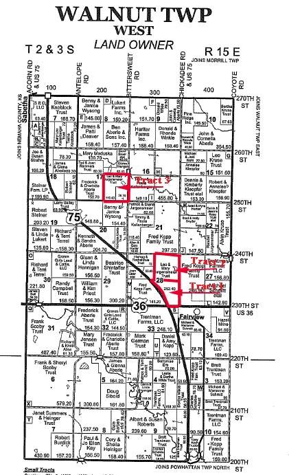
11 Plat Map

12 Surety Map Tract Acres +/-

13 Surety Map Tract Acres +/- Aerial Map map center: 39 51' 7.07, ' ft 512ft 1024ft 28-2S-15E Brown County Kansas 1/15/2019 Field borders provided by Farm Service Agency as of 5/21/2008.

14 Surety Map Tracts 1 & Acres +/-

15 Surety Map Tract Acres +/- Aerial Map map center: 39 52' 27.44, ' ft 472ft 945ft 17-2S-15E Brown County Kansas 1/15/2019 Field borders provided by Farm Service Agency as of 5/21/2008.


16 Soil Map Tracts 1 & Acres +/- Soils Map State: Kansas County: Brown Location: 28-2S-15E Township: Walnut Acres: Date: 1/18/2019 Soils data provided by USDA and NRCS. Area Symbol: KS013, KS013, Soil Soil Area Area Version: Version: Code Soil Description Acres Percent of field Non Irr Class Legend Non Irr Class *c Irr Class *c Corn Soybeans *n NCCPI Overall 7683 Wymore silty clay loam, 3 to 6 percent slopes % IIIe IIIe Padonia Oska silty clay loams, 5 to 9 percent slopes % IVe Wymore silty clay loam, 1 to 3 percent slopes % IIe IIe Kennebec silt loam, frequently flooded % Vw Kennebec silt loam, occasionally flooded % IIw Weighted Average *n 62.4 *n: The aggregation method is "Weighted Average using major components" *c: Using Capabilities Class Dominant Condition Aggregation Method Soils data provided by USDA and NRCS.


17 Soil Map Tract Acres +/- Soils Map State: Kansas County: Brown Location: 17-2S-15E Township: Walnut Acres: Date: 1/15/2019 Soils data provided by USDA and NRCS. Area Symbol: KS013, KS013, Soil Soil Area Area Version: Version: Code Soil Description Acres Percent of field Non Irr Class Legend Non Irr Class *c Irr Class *c Corn Soybeans *n NCCPI Overall 7683 Wymore silty clay loam, 3 to 6 percent slopes % IIIe IIIe Wymore silty clay loam, 1 to 3 percent slopes % IIe IIe Padonia Oska silty clay loams, 5 to 9 percent slopes % IVe Mayberry clay loam, 3 to 7 percent slopes % IIIe Weighted Average *n 60.9 *n: The aggregation method is "Weighted Average using major components" *c: Using Capabilities Class Dominant Condition Aggregation Method Soils data provided by USDA and NRCS.


18 Soil Map Tillable Tract Acres Soils Map State: Kansas County: Brown Location: 28-2S-15E Township: Walnut Acres: Date: 1/15/2019 Soils data provided by USDA and NRCS. Area Symbol: KS013, KS013, Soil Soil Area Area Version: Version: Code Soil Description Acres Percent of field Non Irr Class Legend Non Irr Class *c Irr Class *c *n NCCPI Overall 7683 Wymore silty clay loam, 3 to 6 percent slopes % IIIe IIIe Wymore silty clay loam, 1 to 3 percent slopes % IIe IIe 63 Weighted Average *n 63 *n: The aggregation method is "Weighted Average using major components" *c: Using Capabilities Class Dominant Condition Aggregation Method Soils data provided by USDA and NRCS.


19 Soil Map Tillable Tract Acres +/- Soils Map State: Kansas County: Brown Location: 28-2S-15E Township: Walnut Acres: Date: 1/15/2019 Soils data provided by USDA and NRCS. Area Symbol: KS013, KS013, Soil Soil Area Area Version: Version: Code Soil Description Acres Percent of field Non Irr Class Legend Non Irr Class *c Irr Class *c Corn Soybeans *n NCCPI Overall 7683 Wymore silty clay loam, 3 to 6 percent slopes % IIIe IIIe Padonia Oska silty clay loams, 5 to 9 percent slopes % IVe Wymore silty clay loam, 1 to 3 percent slopes % IIe IIe Kennebec silt loam, frequently flooded % Vw 84 Weighted Average *n 61 *n: The aggregation method is "Weighted Average using major components" *c: Using Capabilities Class Dominant Condition Aggregation Method Soils data provided by USDA and NRCS.

20 Soil Map Tillable Tract Acres +/- Soils Map State: Kansas County: Brown Location: 17-2S-15E Township: Walnut Acres: Date: 1/15/2019 Soils data provided by USDA and NRCS. Area Symbol: KS013, KS013, Soil Soil Area Area Version: Version: Code Soil Description Acres Percent of field Non Irr Class Legend Non Irr Class *c Irr Class *c Corn Soybeans *n NCCPI Overall 7683 Wymore silty clay loam, 3 to 6 percent slopes % IIIe IIIe Wymore silty clay loam, 1 to 3 percent slopes % IIe IIe Mayberry clay loam, 3 to 7 percent slopes % IIIe Padonia Oska silty clay loams, 5 to 9 percent slopes % IVe Weighted Average *n 62.1 *n: The aggregation method is "Weighted Average using major components" *c: Using Capabilities Class Dominant Condition Aggregation Method Soils data provided by USDA and NRCS.
21 Map of Farm 1393 in Brown County, Kansas FSA Map Page 1 of 2 Brown County, Kansas + - Non-Cropland Acres HEL UHEL HEL UHEL UHEL UHEL HEL UHEL HEL UHEL UHEL UHEL UHEL UHEL HEL UHEL HEL UHEL Common Land Unit Cropland Non-cropland CRP Farm 1393 Tract 983 Wetland Determination Identifiers Restricted Use Limited Restrictions Exempt from Conservation Compliance Provisions Leaflet Powered by Esri 2019 Crop Year Tract 1 of 2 United States Department of Agriculture (USDA) Farm Service Agency (FSA) maps are for FSA Program administration only. This map does not represent a legal survey or reflect actual ownership; rather it depicts the information provided directly from the producer and/or National Agricultural Imagery Program (NAIP) imagery. The producer accepts the data 'as is' and assumes all risks associated with its use. USDA-FSA assumes no responsibility for actual or consequential damage incurred as a result of any user's reliance on this data outside FSA Programs. Wetland identifiers do not represent the size, shape, or specific determination of the area. Refer to your original determination (CPA-026 and attached maps) for exact boundaries and determinations or contact USDA Natural Resources Conservation Service (NRCS). 1/25/2019
22 FSA 156 EZ pg 1
23 FSA 156 EZ pg 2
24 FSA 578 pg 1 FSA 578 pg 2

25 FSA 578 pg 3 FSA 578 pg 4
FARMLAND AUCTION. FSA INFORMATION: Farmland: acres Cropland: acres Tillable: acres
 FARMLAND AUCTION January 22, 2019 at 10:30 am Keep an eye on BarnesRealty.com for possible blizzard date of 1/24/2019 Fisher Community Center, 201 E. Iowa St. Hiawatha, KS 66434 Here is a very productive
LAND FOR SALE 82 ACRES M/L CEDAR COUNTY, IOWA LISTING # DOUGLAS R. YEGGE C: O:
 LAND FOR SALE LISTING #13968 82 ACRES M/L CEDAR COUNTY, IOWA DOUGLAS R. YEGGE C: 563-320-9900 O: 563-659-8185 Doug@PeoplesCompany.com ALAN MCNEIL C: 563-321-1125 O: 563-659-8185 Alan@PeoplesCompany.com
Land Sales Specialists Setting the trend for how Real Estate is sold in the Midwest.
 Land Sales Specialists Setting the trend for how Real Estate is sold in the Midwest. www.barnesrealty.com 18156 Hwy 59 Mound City, MO 64470 (660) 442-3177 1711 Oregon Hiawatha, KS 66434 (785) 742-4580
Auction Location Eagles Club 316 S. 2 nd Street, Aberdeen, SD
 Auction Location Eagles Club 316 S. 2 nd Street, Aberdeen, SD Welcome We would like to invite and welcome you to our public auction! This is an excellent opportunity to add Brown County cropland to your
173 ACRES - RILEY COUNTY, KS
 Buyers, Sellers & Land Connected PRICE: $690,000 ACRES: 173 COUNTY: RILEY STATE: KANSAS First Class Hunting with Outstanding Income Potential If you have ever dreamed of owning your very own piece of first
LAND FOR SALE 30 ACRES M/L FLOYD COUNTY, IOWA LISTING # DOUGLAS R. YEGGE C: O:
 LAND FOR SALE LISTING #13886 30 ACRES M/L FLOYD COUNTY, IOWA DOUGLAS R. YEGGE C: 563-320-9900 O: 563-659-8185 Doug@PeoplesCompany.com ALAN MCNEIL C: 563-321-1125 O: 563-659-8185 Alan@PeoplesCompany.com
80 ACRES M/L CEDAR COUNTY, IA LISTING #465 DOUGLAS R. YEGGE ALAN MCNEIL. C: O:
 80 ACRES M/L CEDAR COUNTY, IA LISTING #465 DOUGLAS R. YEGGE C: 563-320-9900 O: 563-659-8185 total@totalrealtyco.com ALAN MCNEIL C: 563-321-1125 O: 563-659-8185 alan@totalrealtyco.com Kroemer, 80 Acres
131 ACRES M/L VAN BUREN COUNTY, IOWA LISTING #458 JIM KEDLEY. C: O:
 131 ACRES M/L VAN BUREN COUNTY, IOWA LISTING #458 JIM KEDLEY C: 563-212-5401 O: 563-659-8185 Jimkedley@totalrealtyco.com CWC Holdings LLC, 131 Acres M/L, Van Buren County, IA TOTAL ACRES: 131 MOL PRICE:
Farmland For Sale 3 Tracts /- acres Webster County, Iowa Section 31, T88N, R30W & Section 33, T88N, R29W
 Farmland For Sale 3 Tracts 316.02 +/- acres Webster County, Section 31, T88N, R30W & Section 33, T88N, R29W Contact Martin today! 309-242-7299 mthornton@hbtbank.com Martin G. Thornton, Broker 200 W. College
Demoss Farm & Home 118 Acres, M/L W. 209th Ave. Pattonsburg, Mo 64670
 118 Acres, M/L 39436 W. 209th Ave. Pattonsburg, Mo 64670 PRICE: $400,000.00 LAND USE: FSA shows approx. 118.32 farmland acres, ml, of which there were 36.47 acres of effective cropland with the remainder
LAND FOR SALE 314 ACRES M/L BERG, WORTH COUNTY, IOWA LISTING # DOUGLAS R. YEGGE C: O:
 LAND FOR SALE LISTING #13870 314 ACRES M/L BERG, WORTH COUNTY, IOWA DOUGLAS R. YEGGE C: 563-320-9900 O: 563-659-8185 Doug@PeoplesCompany.com ALAN MCNEIL C: 563-321-1125 O: 563-659-8185 Alan@PeoplesCompany.com
80 ACRES M/L BOONE COUNTY, IOWA LISTING # Pilot Mound, Iowa. I Avenue. 130th Street. Co Hwy P th Street
 Co Hwy P70 I Avenue 80 ACRES M/L BOONE COUNTY, IOWA CAPTION Pilot Mound, 130th Street 130th Street LISTING #12320 New Listing Price! $800,000 DESCRIPTION: High Quality Farm in Strong Farming Area and potential
268 Acres m/l, Iowa County, IA. Offered in 2 Remaining Parcels. Parcel Ac. m/l Parcel 2-81 Ac. m/l Parcel 3-45 Ac. m/l - SOLD!
 LAND FOR SALE 268 Acres m/l, Iowa County, IA Offered in 2 Remaining Parcels Parcel 1-187 Ac. m/l Parcel 2-81 Ac. m/l Parcel 3-45 Ac. m/l - SOLD! Golden Grain Enterprises Good Iowa County Farms Located
State: Kansas County: Sherman Location: S-037W Township: Union Acres: Date: 12/19/2011. Maps provided by:
 Soils Map State: Kansas County: Sherman Location: 007-009S-037W Township: Union Acres: 147.8 Date: 12/19/2011 Fsa borders provided by the Farm Service Agency as of May 23, 2008. Soils data provided by
Deuel County Dryland
 Deuel County Dryland Two parcels of dryland farm ground near Lewellen, NE Property Highlights List Price $852,474 $786,877 Location 12-15 miles south of Lewellen, Ne or the same distance from Big Springs,
WALKER FEEDLOT Total taxable acres, part fenced. 4 homes & multiple nice/modern outbldgs hd feedyard with sprinklers a-shkd-0002
 ABILENE WALKER FEEDLOT 38.7 Total taxable acres, part fenced 4 homes & multiple nice/modern outbldgs 3500 hd feedyard with sprinklers a-shkd-0002 Center pivot irrigation from lagoons 999 hd feedlot A-SHDK-B020
Northeast Perkins County Pivots
 Northeast Perkins County Pivots 315.9± acres of center pivot irrigated farmland Southeast of Paxton, NE Email: Jordan@lashleyland.com Property Highlights List Price $1,550,000 Location Southeast of Paxton,
Pifer s. 1, /- Acres Clay County, MN. Written Bid. Land For Lease. WRITTEN BIDS DUE BEFORE: Friday, January 19, :00 p.m.
 1,666.53 +/- Acres Clay County, MN Written Bid Land For Lease WRITTEN BIDS DUE BEFORE: Friday, January 19, 2018 5:00 p.m. OWNER: Hogetvedt Family Rev Trust STOCK PHOTO General Information Land Lease Auction
Aerial Map. map center: 38 0' 55.53, ' S-4E Franklin County Illinois
 Aerial Map map center: 38 0' 55.53, -88 42' 58.78 0ft 594ft 1188ft 11/24/2016 Field borders provided by Farm Service Agency as of 5/21/2008. Soils data provided by University of at Champaign-Urbana. Topography
LAND AUCTION. Open House: Saturday, August 6th and Saturday, August 20th From 9:00 AM to 11:00 AM at 1220 C Avenue, Scranton, Iowa
 L-1005 LAND AUCTION 1,235+/- Acres, Carroll and Greene Counties, Iowa Friday, August 2, 201 10:00 AM at the Saint Joseph s Parish Center 501 North Locust Street Jefferson, Iowa Highlight Features: Over
+/- 60 AC LAND FOR SALE HARLEY ROAD, ELBURN, IL 60119
 Land For Sale OFFERING SUMMARY Sale Price: $660,000 Price / Acre: $11,000 PROPERTY OVERVIEW +/- 60 acres available for purchase on the west side of Harley Road, South of Rt. 38. This site has Harley Road
Harding Real Estate Vacant Acres Thompson Rd., Woodstock, IL
 Harding Real Estate 325.31 Vacant Acres Thompson Rd., Woodstock, IL Randy Erwin, Broker Associate Natalie Torres, Broker Associate BHHS Starck Real Estate 1710 South Eastwood Dr. Woodstock, IL. 60098 Randy@RandyErwin.com
FOR SALE HILL FAMILY FARM WATKINS CORNER, AR. Phillips County, Arkansas: 2,300+/- Acre Irrigated Grain Farm NEW PRICE/YIELD UPDATES:
 SOLD FARMLAND ADVISORS FOR SALE HILL FAMILY FARM WATKINS CORNER, AR 2,300+/- Acres - Phillips County, Arkansas $10,950,000 Phillips County, Arkansas: 2,300+/- Acre Irrigated Grain Farm NEW PRICE/YIELD
FOR SALE NEW PRICE HILL FAMILY FARM WATKINS CORNER, AR. Phillips County, Arkansas: 2,300+/- Acre Irrigated Grain Farm NEW PRICE/YIELD UPDATES:
 NEW PRICE FARMLAND ADVISORS FOR SALE HILL FAMILY FARM WATKINS CORNER, AR 2,300+/- Acres - Phillips County, Arkansas $10,950,000 Phillips County, Arkansas: 2,300+/- Acre Irrigated Grain Farm NEW PRICE/YIELD
For Sale at $290,000.00
 We are pleased to present Stearns Property 77± Acres Forest Township, Rice County For Sale at $290,000.00 Listing Agent: Charles Wingert Office: 507-345-LAND (5263) Toll Free: 800-730-LAND (5263) Direct:
LAND FOR SALE. Beautiful Farmstead. Pifer s. Price: $1,250, /- Acres Green County, WI
 Beautiful Farmstead LAND FOR SALE 176 +/- Acres Green County, WI Price: $1,250,000 Auction & Realty - Robert Scott Pifer, Broker (#56685-90) RE Entity License #937110-91, Auction Company License #429-53
280 ACRES - HOWELL COUNTY, MO
 PRICE: $434,700 ACRES: 280 COUNTY: HOWELL STATE: MISSOURI For more information contact: KYLE ORF, Land Agent 417.988.3333 KyleOrf@MidwestLandGroup.com MidwestLandGroup.com 100 280ACRES ACRES- -COUNTY,
SW CORNER ROUTE 38 AND HARLEY ROAD SW CORNER ROUTE 38 & HARLEY ROAD, KANE COUNTY, IL 60119
 REDUCED: Land For Sale SW CORNER ROUTE 38 AND HARLEY ROAD REDUCED: 124 AC ON IL ROUTE 38 OFFERING SUMMARY Sale Price: $1,643,000 Price / Acre: $13,250/AC PROPERTY OVERVIEW This 124 AC parcel has approximately
FARMLAND FOR SALE ± Acres 5 Tracts
 Now is your chance to acquire productive farmland in Greene County, Illinois. Greene County, IL FARMLAND FOR SALE 756.08± Acres 5 Tracts Highly productive riverbottom farms Heavily improved with tiling
/- Acres Becker County, MN (see pgs 1-6) /- Acres Clay County, MN (see pgs 8-14) Pifer s Written Bid.
 /- Acres Clay County, MN (see pgs 8-14) Pifer s Written Bid.") 812.02 +/- Acres Becker County, MN (see pgs 1-6) 810.14 +/- Acres Clay County, MN (see pgs 8-14) Written Bid Land For Lease WRITTEN BIDS DUE BEFORE: Friday, December 8, 2017 5:00 p.m. OWNERS: Case Agricultural
812.02 +/- Acres Becker County, MN (see pgs 1-6) 810.14 +/- Acres Clay County, MN (see pgs 8-14) Written Bid Land For Lease WRITTEN BIDS DUE BEFORE: Friday, December 8, 2017 5:00 p.m. OWNERS: Case Agricultural
G T12 G J44 G J46 ST 2. Jerome. Martinstown. Numa. A Maryanna F. Wallin Estate Appanoose County, Iowa
 135th Ave 150th Ave 153rd Ave Elm St N 170th Ave 171st Ave 172nd St 175th Ave 51 0th St Highw ay 2 Highw ay 2 ST 2 Highw ay 2 G T12 135th Ave 522nd St 523rd St Jerome 140th Ave 524th St 1 2 G J44 3 160th
We are pleased to present Leonard Thorston Revocable Trust ± Acres Charleston Township, Redwood County
 We are pleased to present Leonard Thorston Revocable Trust 158.72 ± Acres Charleston Township, Redwood County PARCEL 1 PARCEL 2 This property to be sold by Sealed Bid Auction Owner: Leonard Thorston Family
Tract 1. Tract 3. Tract 2. Tract 4. A Taylor Co., IA
 Newport Ave Sec. 7 Sec. 8 235th St Sec. 13 250 th St Sec. 18 Maryl and Ave Sec. 17 T68N R34W T68N R33W 250 th St Sec. 24 257t h St Sec. 19 2 Newp ort Way Sec. 20 Sec. 25 Latitude: 40.6872 N Longitude:
Sacramento River Farmland Anderson, California
 AG-LAND INVESTMENT BROKERS 275 Sale Lane / P. O. Box 896 Red Bluff, CA 96080 530.529.4400 office / 530.527.5042 fax Sacramento River Farmland Anderson, California Property: 43 +/- acres of farmland with
We are pleased to present Delwyn Spronk Farm ± Acres Elmer Township, Pipestone County
 We are pleased to present Delwyn Spronk Farm 79.09 ± Acres Elmer Township, Pipestone County SUBJECT PROPERTY This property to be sold by Sealed Bid Auction Owner: Delwyn & Julie Spronk Owner s Attorney:
Colusa County Almonds
 Morgan Houchin. 3430 Unicorn Road Bakersfield, CA 93308 mobile office efax 526.97 +/- Acres of Colusa County Almonds Cork McIsaac, Broker. Broker License No. 01216717 P.O. Box 1076 West Sacramento, CA
Land for Sale. Marion County, Georgia. $2,160,000 +/- 900 Acres $2,400 per Acre
 Land for Sale Marion County, Georgia 2 Contents Property Fact Sheet... 3 Regional Map... 4 Local Map... 5 Aerial Map... 6 Major Soil Types Map... 7 Soil Classification Map... 8 Soil Classification Table...
Farmland Classification Centre County, Pennsylvania (Student Farm Site) Web Soil Survey National Cooperative Soil Survey
 Web Soil Survey National Cooperative Soil Survey") 256300 256600 256900 257200 257500 257800 258100 77 51' 20'' W 77 53' 26'' W Farmland Classification Centre County, Pennsylvania 258400 258700 259000 40 49' 4'' N 4520600 4520900 4520900 4521200 4521200
256300 256600 256900 257200 257500 257800 258100 77 51' 20'' W 77 53' 26'' W Farmland Classification Centre County, Pennsylvania 258400 258700 259000 40 49' 4'' N 4520600 4520900 4520900 4521200 4521200
Horner-McLaughlin Woods: Soil Types
 Horner-McLaughlin Woods: Soil Types Not present at HMW Adrian Muck Conover Loam 0-4% Slopes Houghton Muck Miami Loam 2-6% Slopes Miami Loam 6-12% Slopes Miami Loam 12-18% Slopes t 0 0.125 0.25 Miles Mary
2014 Iowa FFA Soil Judging CDE Exam
 2014 Iowa FFA Soil Judging CDE Exam 1. Landscape position is one aspect of evaluating the surface features of a certain tract of land. Identifying the correct landscape position will indicate: a. If the
Darlington Pines 1,295. At a Glance: Property Features. Acreage: 622 +/- acres (Sub-dividable) Asking Price:
 Asking Price:") ONLY $ 1,95 PER ACRE Property Features Located in the fertile northern reaches of Holmes County, Florida, the 6-acre tract has been continuously owned by the Spann family for over 50 years, once serving
ONLY $ 1,95 PER ACRE Property Features Located in the fertile northern reaches of Holmes County, Florida, the 6-acre tract has been continuously owned by the Spann family for over 50 years, once serving
Richfield Prunes, Pistachios & Walnuts
 AG-LAND Investment Brokers 275 Sale Lane Red Bluff, CA 96080 530-529-4400 Fax 530-527-5042 Richfield Prunes, Pistachios & Walnuts 210 +/- acres 3 Parcels Corning, CA - Tehama County jsubject AG-LAND
Bull Canyon Ranch 2750 BULL CANYON ROAD, SANTA MARIA, CALIFORNIA PRESENTED FOR SALE BY: Rincon corporation
 Bull Canyon Ranch 2750 BULL CANYON ROAD, SANTA MARIA, CALIFORNIA PRESENTED FOR SALE BY: Rincon corporation THE FULL SERVICE REAL ESTATE COMPANY FOR THE AGRICULTURAL COMMUNITY Bull canyon ranch, santa maria
Soils and their Relationship with Agriculture
 Soils and their Relationship with Agriculture Presentation created by Thomas Gallagher Modified by Hank Bignell Capital Area Agriculture and Horticulture Program Cornell University Cooperative Extension
Custom Soil Resource Report for Craighead County, Arkansas
 United States Department of Agriculture Natural Resources Conservation Service A product of the National Cooperative Soil Survey, a joint effort of the United States Department of Agriculture and other
2 Older farm homes on the land
 2 Older farm homes on the land LAND RANCHES EXCHANGES This ranch consists of 70 +/_ acres of level farmland. Prime 13700 POWERHOUSE RD POTTER VALLEY agricultural land at an attractive price. This property
 108 40' 29'' W Soil Map Mesa County Area, Colorado 108 36' 55'' W 39 10' 11'' N 39 6' 31'' N 4331700 4332500 4333300 4334100 4334900 4335700 4336500 4337300 4338100 701100 701900 702700 703500 704300 705100
House & 3.21 Acres, Linn County, IA. 927 Linn Ridge Road, Mount Vernon, Iowa 52314
 ACREAGE FOR SALE House & 3.21 Acres, Linn County, IA 927 Linn Ridge Road, Mount Vernon, Iowa 52314 Property Information Location From Mount Vernon: Four miles north on Springville Road and one mile west
Land for Sale. Baker County, Georgia. $4,960,000 1,984 Acres $2,500 per Acre
 Land for Sale Baker County, Georgia $4,960,000 1,984 Acres $2,500 per Acre 2 Contents Property Fact Sheet... 3 Regional Map... 4 Local Map... 5 Aerial Map... 6 Major Soil Types Map... 7 Soil Classification
Yields of Non-Irrigated Crops (Component): Soybeans (Bu) Edgecombe County, North Carolina, and Halifax... (SOYBEANS)
: Soybeans (Bu) Edgecombe County, North Carolina, and Halifax... (SOYBEANS)") 77 37' 52'' W Yields of Non-Irrigated Crops (Component): Soybeans (Bu) Edgecombe County, North Carolina, and Halifax... () 77 36' 28'' W 263300 263600 263900 264200 264500 264800 265100 36 6' 59'' N 36
77 37' 52'' W Yields of Non-Irrigated Crops (Component): Soybeans (Bu) Edgecombe County, North Carolina, and Halifax... () 77 36' 28'' W 263300 263600 263900 264200 264500 264800 265100 36 6' 59'' N 36
FOR SALE. Arvin Edison Vineyard & Open Land Gross Acres Kern County, CA
 Arvin Edison Vineyard & Open Land FOR SALE Property Highlights Arvin Edison Water Storage District Class I and II Soils Neighboring properties planted to almonds, vineyards, and citrus The information
September 20, 2016 Soils Investigation for Agricultural Designation Windemere Place, Missoula County, Montana
 September 20, 201 Soils Investigation for Agricultural Designation Windemere Place, Missoula County, Montana The purpose of this report is to compare on-site soils of the proposed subdivision with the
Area 3 Envirothon Soils Questions Key
 Area 3 Envirothon Soils Questions Key 1. Soil aeration is the exchange of air in soil with air from the atmosphere. When a soil is well aerated, the air within the soil is very similar to the atmosphere
FOR SALE ± ACRES VALENTINES, VIRGINIA Price: $150,000
 LATITUDE & LONGITUDE 36.566924, -77.764781 Features STRONG RECREATIONAL INVESTMENT opportunity located south of Triplet with access from VSR 600 (Triplet Rd.) to the north. TRACT HAS BEEN RECENTLY CUTOVER
Rural Soils Career Development Event
 Rural Soils Career Development Event Effective August 1, 2014 Important Note: Please thoroughly read the Introduction and General Rules Section at the beginning of this handbook for complete rules and
2016 Iowa FFA Soils Evaluation CDE Exam
 2016 Iowa FFA Soils Evaluation CDE Exam 1. Which of the following is true regarding soil horizons? a. A horizon is darker in color and has more organic matter b. B horizon is darker in color and has more
Custom Soil Resource Report Soil Map
 77 11' 22'' W Custom Soil Resource Report Soil Map 77 9' 43'' W 36 48' 13'' N 304700 304900 305100 305300 305500 305700 305900 306100 306300 306500 306700 306900 307100 36 48' 13'' N 36 47' 21'' N 4073800
NYC Envirothon 2017 Soil Science Review. Richard K Shaw USDA-NRCS
 NYC Envirothon 2017 Soil Science Review Richard K Shaw USDA-NRCS Introduction Who Are We? U.S. Department of Agriculture (1862) Natural Resources Conservation Service (1935) What Do We Do? Provide leadership
Predicting Design Storm Runoff for the Six Mile Creek Watershed: Effects of the Potential Sprawl-Is-Us, Inc. Development
 Predicting Design Storm Runoff for the Six Mile Creek Watershed: Effects of the Potential Sprawl-Is-Us, Inc. Development Ross Guida Faulkner Consulting Engineers, Inc. December 19, 2008 1 Table of Contents
Custom Soil Resource Report for Kane County, Illinois
 United States Department of Agriculture Natural Resources Conservation Service A product of the National Cooperative Soil Survey, a joint effort of the United States Department of Agriculture and other
Procedures IV. V. Rural Road Design Option
 i IV. Procedures A. All applicants required to prepare a Conservation Design Subdivision shall provide the Planning Board with a conceptual conventional subdivision design as well as a proposed layout
Soil characteristics that influence nitrogen and water management
 Section C Soil characteristics that influence nitrogen and water management Soil characteristics vary across the landscape Soils vary from one field to another, and often within the same field. Soil differences
Custom Soil Resource Report for Fond du Lac County, Wisconsin
 United States Department of Agriculture Natural Resources Conservation Service A product of the National Cooperative Soil Survey, a joint effort of the United States Department of Agriculture and other
Alternative Crop Suitability Methodology
 Alternative Crop Suitability Methodology The Alternative Agriculture in Missouri Hub on Community Commons includes model-based ratings of natural suitability for selected alternative crops. These ratings
Exhibit A. 8:9 Scuffletown Rural Conservation District
 Exhibit A 8:9 Scuffletown Rural Conservation District 8:9.1 Intent and Purpose The Scuffletown Rural Conservation (SRC) District is intended to provide for residential development that supports the development
Custom Soil Resource Report for Orange County, Virginia
 United States Department of Agriculture Natural Resources Conservation Service A product of the National Cooperative Soil Survey, a joint effort of the United States Department of Agriculture and other
Custom Soil Resource Report for Daviess County, Missouri
 United States Department of Agriculture Natural Resources Conservation Service A product of the National Cooperative Soil Survey, a joint effort of the United States Department of Agriculture and other
2016 Area 3 Envirothon Muskingum County Soils Test ANSWER KEY
 2016 Area 3 Envirothon Muskingum County Soils Test ANSWER KEY 1. The majority of the bedrock in Muskingum County is. a. sedimentary bedrock b. glacial bedrock c. igneous bedrock d. metamorphic bedrock
ARTICLE IV: DEVELOPMENT STANDARDS 404 MASTER PLANNING
 IV 13 404 MASTER PLANNING Master Planning through the Site Analysis (Master Planning Site Analysis) or Planned Development (Master Planning Planned Development) is provided to encourage development which
RaC. RaD GlG. GlF. RaD GlE. CeA. RaE. RcD. GoF. GoF SkC. SkD. CfA. AdA. GoF. GoF. GoF. RcD. GgD. GoF. RaE GlE. RaE DbF. GoF. DbE. RaC.
 526300 527400 528500 529600 530700 531800 532900 534000 535100 4240200 4241300 4242400 4243500 4244600 4245700 ADRIAN DR FAIRWAY DR STATE FARM DR DOLORES DR HUDIS ST SANTA ALICIA DR Cotati PAGE ST ALTA
CHECKLIST BMPs for FIELD NURSERIES REGULATIONS, SITE SELECTION, WATER MANAGEMENT
 CHECKLIST BMPs for FIELD NURSERIES REGULATIONS, SITE SELECTION, WATER MANAGEMENT Regulations For information on the Wetlands Protection Act or the Water Management Act, contact the Massachusetts Department
Annual lease of the tillable acreage for crops (soybeans and/or corn).
.") FOR SALE $895,000.00 11201 Hill Road, Woodsboro, Maryland 21798 Crop Farm with Subdivision Potential PRESENTING Location: 11201 Hill Road, Woodsboro, MD 132.2064 acre crop farm with extraordinary views,
FOR SALE $895,000.00 11201 Hill Road, Woodsboro, Maryland 21798 Crop Farm with Subdivision Potential PRESENTING Location: 11201 Hill Road, Woodsboro, MD 132.2064 acre crop farm with extraordinary views,
TP73 4PTP101 TP45 TP9 TP74 TP46 TP47 TP115 TP48 TP32 TP5 TP31 TP22 TP49 V58 TP57 4F TP50 TP51 3PD 3PD TP80 TP28 TP55
 Figure 2.1-3 - Capability Assessment Map Part of Lots 18 and 19, Concession 3 Township of Russell sified unclas TP72 TP90 TP624P V18 3D TP35 TP73 4PTP101 3D TP45 TP9 TP74 TP89 TP117 V61 V34 TP19 TP20 TP100
2012 FINAL SOILS AREA 2 Envirothon Questions Answer KEY
 2012 FINAL SOILS AREA 2 Envirothon Questions Answer KEY Questions 1-6 to be answered at the soil pit: 1. Soil scientists categorize soils by drainage classes. What is the drainage class of the soil at
Non-Metallic Mining Reclamation Checklist
 Eau Claire County DEPARTMENT OF PLANNING AND DEVELOPMENT Eau Claire County Courthouse, Rm. 1510 721 Oxford Avenue Eau Claire, Wisconsin 54703-5481 (715) 839-4741 f Housing & Community Development 839-6240
Custom Soil Resource Report for Yamhill Area, Oregon
 United States Department of Agriculture Natural Resources Conservation Service A product of the National Cooperative Soil Survey, a joint effort of the United States Department of Agriculture and other
EXHIBIT 5-1 VILLAGE OF WILD ROSE FUNCTIONAL CLASS AND AVERAGE DAILY TRAFFIC VOLUMES 2000 & 2003 DATA
 3400 3600 EXHIBIT 5-1 FUNCTIONAL CLASS AND AVERAGE DAILY TRAFFIC VOLUMES 2000 & 2003 DATA Rural Minor Arterial Rural Major Collector Rural Minor Collector Rural Local 2000 Traffic Count 2003 Traffic Count
SUBMITTAL REQUIREMENTS
 WHEN PROCESS TYPE III IS USED References to Process Type III applications are found in several places in the Milton Municipal Code (MMC), indicating that the development, activity, or use, is permitted
Custom Soil Resource Report for Pope County, Illinois
 United States Department of Agriculture Natural Resources Conservation Service A product of the National Cooperative Soil Survey, a joint effort of the United States Department of Agriculture and other
3. What are the five master horizons? Give distinguishing features of each. 5. List three means by which plant roots come into contact with nutrients.
 Study Questions Exam 1 1. What are the four general components of soil? 2. Define regolith and solum. 3. What are the five master horizons? Give distinguishing features of each. 4. What is meant by an
We are pleased to present
 We are pleased to present Zenk Farms 57 ± Acres Lowville Township, Murray County 80 ± Acres Lowville Township, Murray County 150 ± Acres Mason Township, Murray County 150.31 ± Acres Slayton Township, Murray
SOUTH PLAINS PUBLIC HEALTH DISTRICT
 1 SOUTH PLAINS PUBLIC HEALTH DISTRICT ENVIRONMENTAL HEALTH SERVICES Proudly Serving the Communities of Gaines, Yoakum, Terry, Dawson and Lynn Counties APPLICATION FOR NEW CONSTRUCTION OR MODIFICATION 1.
Checklists. Project Name: Location: File Number: Date of Submittal: Reviewer: Date: Applicant: Contact Name: Phone Number:
 Applicant: Contact Name: Phone Number: Email: Project Name: Location: File Number: Date of Submittal: Reviewer: Date: Concept Plan Requirements: I. General Project Information 1. Address or parcel number
NOTICE OF TAX FORECLOSURE WALLER COUNTY COURTHOUSE, EAST SIDE ASSEMBLY ROOM
 NOTICE OF TAX FORECLOSURE DATE AND TIME OF SALE: DECEMBER 5, 2017 AT 10:00 A.M. PLACE: WALLER COUNTY COURTHOUSE, EAST SIDE ASSEMBLY ROOM The property listed below will be sold at Sheriff s Sale in the
Blue Fox Farm $1,795,000
 Offered Exclusively By: Blue Fox Farm 6105 Sulphur Well Road 117± acres Fayette County $1,795,000 Zach Davis Principal Broker +1.859.576.8195 www.kirkfarms.com zach@kirkfarms.com Hannah Davis Emig Agent
2011 Wisconsin Envirothon Soils and Land Use Exam
 2011 Wisconsin Envirothon Soils and Land Use Exam USE THE OCONTO COUNTY SOIL SURVEY TO ANSWER QUESTIONS 1-4 The Pensaukee River Wetland Complex is a mixture of state (Pensaukee Wildlife Area) and privately
Information for File # MHK
 Information for File #2014-03555-MHK Applicant: Corps Contact: Wimmer Communities Marie Kopka Address: 250 N. Sunnyslope Road, Suite 296 Brookfield, Wisconsin 53005 E-Mail: Marie.H.Kopka@usace.army.mil
SOIL SEPARATES. Soil Evaluator Day 2, Presentation 3-3/27/2018. Soil Texture, Page 1 TITLE 5 SOIL EVALUATOR CERTIFICATION TRAINING SOIL TEXTURE
 Soil Evaluator Day 2, Presentation 3-3/27/18 TITLE 5 SOIL EVALUATOR CERTIFICATION TRAINING SOIL TEXTURE Prepared for: Commonwealth of Massachusetts Department of Environmental Protection By L.A. Spokas,
Custom Soil Resource Report for Clark County, Missouri
 United States Department of Agriculture Natural Resources Conservation Service A product of the National Cooperative Soil Survey, a joint effort of the United States Department of Agriculture and other
Environmental Protection Ordinances (Performance Zoning) Bedminster Township, Bucks County
 Bedminster Township, Bucks County") Environmental Protection Ordinances (Performance Zoning) Bedminster Township, Bucks County ARTICLE VI. PERFORMANCE STANDARDS Section 600 Compliance All uses, activities, subdivisions and/or land developments
Environmental Protection Ordinances (Performance Zoning) Bedminster Township, Bucks County ARTICLE VI. PERFORMANCE STANDARDS Section 600 Compliance All uses, activities, subdivisions and/or land developments
Post-Harvest Management: The Economics of Grain Drying
 Post-Harvest Management: The Economics of Grain Drying Alex Butler, Dr. Jordan Shockley, Dr. Sam McNeill, and Dr. Todd Davis Agricultural Economics & Biosystems & Agricultural Engineering INTRODUCTION
Analysis of Environs of Clinton Park located at 901 W 5 th Street
 Environs Definition p.1 Analysis of Environs of Clinton Park located at 901 W 5 th Street Step One Historical Significance and Context Clinton Park was identified on Searl s first survey plan for Lawrence
THREE-STEP DESIGN PROCESS FOR OPEN SPACE SUBDIVISIONS
 00216106.DOC NMA/RRK 1/30/14 THREE-STEP DESIGN PROCESS FOR OPEN SPACE SUBDIVISIONS Open space subdivisions, sometimes called cluster developments, maintain a significant portion of a development site in
Custom Soil Resource Report for Southampton County, Virginia
 United States Department of Agriculture Natural Resources Conservation Service A product of the National Cooperative Soil Survey, a joint effort of the United States Department of Agriculture and other
11: Good Design - Boor Site
 Rural Design Workbook: 11: Site Introduction: A dairy and feed farm of over 450 acres in the town of Horseheads (Chemung County), David Boor s property has a number of notable features. The site is nearly
IOWA FFA STATE SOILS CDE SATURDAY, OCTOBER 13, 2007 AMES, IOWA
 IOWA FFA STATE SOILS CDE SATURDAY, OCTOBER 13, 2007 AMES, IOWA 1. Moderately sloping has what percent slope: a. 9-14% b. 2-5% c. 5-9% d. over 14% 2. Which of the following horizons is the loose underlying
Level 1: GIS-based Desktop Assessments. Meghan Burns, Landscape Ecologist
 Level 1: GIS-based Desktop Assessments Meghan Burns, Landscape Ecologist EPA three-tier framework WETLAND AND RIPARIAN MAPPING LEVEL 1 LANDSCAPE ASSESSMENT WETLAND LANDSCAPE PROFILES LEVEL 2 RAPID ASSESSMENT
NRCS Soil Survey Prime Agricultural Land *
 Prime Agricultural Soil cr en to ve r iv e r Sa am Ri Sa n a Jo qu in R Ol d Ri ve r NRCS Soil Survey Prime Agricultural Land * Map created 8/05/2015 This map or dataset was created by the Contra Costa
John R Trainor Park Bidwell Park Bidwell-Sacramento River SP SITE Lake Oroville State Rec Area Alpine Park
 FIGURES 1. Site Vicinity Map 2. Site Map Showing Compost Pad Layout and Facility Features 3. Wells Within One Mile of Facility and Groundwater Basin Contour Map 4. Geologic Map 5. Soils Map 6. Zoning Map
SOIL DATA: Avondale. in Allen, TX. This information was taken from NRCS web soil survey of Collin County, Texas.
 SOIL DATA: Avondale in Allen, TX This information was taken from NRCS web soil survey of Collin County, Texas. United States Department of Agriculture Soil Conservation Service in cooperation with Texas