THE SCORE CARD. Observed Soil Properties. Interpretive Soil Properties
|
|
|
- Britton Morgan
- 6 years ago
- Views:
Transcription


1 Rev. 07/18/2008 Jim Doolittle Doug Malo Tom Schumacher Plant Science Department SDSU and Kent Cooley Lance Howe Bruce Kunze Jim Millar Walt Schaefer Dan Shurtliff Steve Winter USDA Natural Resources Conservation Service
2 THE SCORE CARD Observed Soil Properties Interpretive Soil Properties

3 Soil Texture
4 What is soil texture? The amount of sand, silt, and clay in a soil sample. (coarse) (medium) (fine) Sand Silt Clay 2.0 to 0.05 mm in diameter 0.05 to mm in diameter mm in diameter Sand, silt, and clay are terms used to describe the size of soil particles within a soil sample.
 Next, estimate the volume of sand.")
5 SOIL TEXTURE TRIANGLE Estimate the texture of a soil sample by using a Soil Texture Triangle. First, estimate the clay content (use the procedure shown in Fig. 6 of the SDSU publication Land Judging in South Dakota. ) Next, estimate the volume of sand. Once the percentages of clay and sand are determined, find the percentages on the texture triangle and extend the two lines. The point where they intersect is the texture of the sample. In this example, the soil sample has an estimated clay content of 25 percent and a sand content of 30 percent. The two lines intersect in the loam section of the triangle. In land judging, the term medium is used instead of loam.


6 SOIL TEXTURE The Extremes Coarse-textured soil samples contain a high percentage of sand-size particles. Some samples may be cloddy when dry but are easily broken when moistened. 1 Fine-textured soil samples contain a high percentage of clay-size particles that stick together to form clods. These clods are hard when dry and sticky and plastic when wet. 1


7 DETERMINING SOIL TEXTURE BY FEEL METHOD STEP 1: Crush Sample STEP 2: Moisten Sample


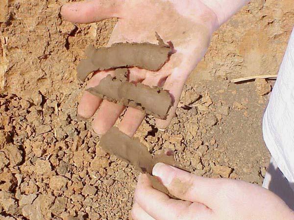
8 DETERMINING SOIL TEXTURE BY FEEL METHOD STEP 3: Work Sample STEP 4: Ribbon Sample
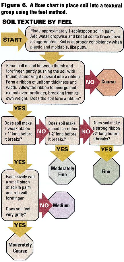
9 DETERMINING SOIL TEXTURE BY FEEL METHOD

10 Differences between Medium and Fine Textures 1 Characteristics Porous Subrounded edges Easy to difficult to crush Dull surfaces Dry sample of MEDIUM texture
11 Differences between Medium & Fine Textures Characteristics Non-porous Angular surfaces Difficult to crush Shiny surfaces 1 Dry sample of FINE texture


12 Differences between Medium & Fine Textures Side-by-side Comparison Medium 1 Fine


 are misnomers")

.")
13 Soil Color Soil gets its color from materials and conditions in which the soil is formed. Soil color is NOT an indication of soil texture. The familiar terms black dirt (referring to the topsoil) and yellow clay (referring to the subsoil) are misnomers because sand, silt, and clay can vary in color from white, gray, black, yellow, brown, olive, and red (and all colors in between). Soil colors CAN give an indication of its wetness, chemical composition, and organic matter content.
14 Soil Color - Examples Very Dark Brown In this soil, the color of the topsoil indicates a high organic matter content. The topsoil here has a medium texture. 0 1 Light Brown with white splotches The color of this subsoil indicates a high calcium carbonate content (white splotches ) and a decrease in organic matter. The subsoil in this example has a moderately fine texture. 2 3


15 Soil Color - Examples Black: The color in this soil could indicate a high organic matter content and/or soils that are wet for long periods. The texture in this subsoil is fine. Reddish Brown: The color of this subsoil could be an indication of low organic matter and a highly oxidized or well drained soil. This subsoil has a moderately fine texture. Light Gray: The color of this soil could be and indication of low organic matter and high lime content. The texture of the entire area shown here is medium.
 Bedrock/Rock (shale, sandstone, slate)")
16 EVALUATING SOIL DEPTH Examples of Unfavorable Root Zones Coarse sand More than 15 percent gravel/cobbles with coarse textures Sodium-affected subsoil (columnar structure) Bedrock/Rock (shale, sandstone, slate)


17 EVALUATING SOIL DEPTH Deep soil with lime at 18 inches Moderately Deep soil with bedrock at 36 inches


18 EVALUATING SOIL DEPTH Shallow soil with fractured bedrock at 12 inches Very Shallow soil with sand/gravel at 7 inches
19 PAST EROSION How much of the soil has been lost to erosion? To determine this, first determine how thick the topsoil is. Get down in the pit and look for a change in texture, color and/or structure. Measure from the surface down to that point. That point is the current thickness of the topsoil
20 PAST EROSION Example: You determine the current thickness of the topsoil is 7 inches. The site info card states that Original topsoil thickness was 12 inches. How much soil was lost through erosion? Soil Loss = Current Thickness x 100 Original Thickness Soil Loss = 7 x Soil Loss =.58 x 100 Soil Loss = 58% (moderate)


21 Examples of EROSION and DEPOSITION EROSION DEPOSITION

22 EROSION Choice List none-slight moderate severe deposition 1 severe 2 none-slight 3 severe 4 moderate 5 deposition
23 ESTIMATING SLOPE
24 ESTIMATING SLOPE 5 percent slope In this example, the slope stakes are 100 feet apart. The height of the student s eyes are about five feet from the ground. He shoots a level line and it hits the base of the upper stake. What is the percent slope?
25 ESTIMATING SLOPE 3 percent slope 3 ft. Slope stakes are 100 feet apart

26 ESTIMATING SLOPE 7 percent slope 2 ft. 5 ft. Slope stakes are 100 feet apart
27 EVALUATING STONINESS

28 EVALUATING STONINESS REMEMBER: Only evaluate stones that are greater than 10 inches in diameter.
29 EVALUATING STONINESS None to Slight Less than 1 percent of the surface is covered with stones greater than 10 inches in diameter >30 ft. apart


30 EVALUATING STONINESS Moderate 1 to 3 percent of the surface is covered with stones greater than 10 inches in diameter 5 to 30 ft. apart
31 EVALUATING STONINESS Excessive > 3 percent of the surface is covered with stones greater than 10 in diameter Less than 5 ft. apart

32 Young vs. Mature Soil Effects of Time Young Soil Mature Soil


33 Young Soil vs. Mature Soil Effects of Landform Position (tape in inches) Young Soil - on flooded landform position Mature Soil on stable landform position

34 SOIL STRUCTURE AND PERMEABILITY GRANULAR STRUCTURE Usually characteristic of the topsoil. This type of structure has RAPID permeability. 1/8

35 SOIL STRUCTURE AND PERMEABILITY PLATY STRUCTURE Characteristic of the surface or subsurface horizon of some mature forest soils and sodiumaffected prairie soils. Platy structure has SLOW permeability. 1/2

36 SOIL STRUCTURE AND PERMEABILITY COLUMNAR STRUCTURE 2 Indicates a sodiumaffected subsoil. Moderately fine texture has SLOW permeability. Fine texture has VERY SLOW permeability.

37 SOIL STRUCTURE AND PERMEABILITY BLOCKY STRUCTURE 1 Commonly found in the of subsoil of most soils. Moderately coarse, medium or moderately fine textures have MODERATE permeability. Fine texture has SLOW permeability.

38 SOIL STRUCTURE AND PERMEABILITY 2 PRISMATIC STRUCTURE Common structure in the subsoil of mature soils. Moderately coarse, medium or moderately fine textured have MODERATE permeability. Fine texture has SLOW permeability.
39 THE SCORE CARD Mechanical Erosion Treatments

40 Diversion Terrace USE WHERE OVERHEAD WATER IS A PROBLEM

41 Farming on the Contour USE ON TILLABLE LANDS OF 3 TO 6 PERCENT SLOPES

42 Terrace and Farm on the Contour USE ON TILLABLE LANDS WITH SLOPES >6 PERCENT

43 Grass Waterway USE WHERE OVERLAND WATER IS A PROBLEM
44 Non-Discrimination Statement The U.S. Department of Agriculture (USDA) prohibits discrimination in all its programs and activities on the basis of race, color, national origin, age, disability, and where applicable, sex, marital status, familial status, parental status, religion, sexual orientation, genetic information, political beliefs, reprisal, or because all or a part of an individual's income is derived from any public assistance program. (Not all prohibited bases apply to all programs.) Persons with disabilities who require alternative means for communication of program information (Braille, large print, audiotape, etc.) should contact USDA's TARGET Center at (202) (voice and TDD). To file a complaint of discrimination write to USDA, Director, Office of Civil Rights, 1400 Independence Avenue, S.W., Washington, D.C or call (800) (voice) or (202) (TDD). USDA is an equal opportunity provider and employer.
Ecological Sites. Topics of Discussion 2/28/2014. Ecological Site Classification. Ecological Site Key. Ecological Site Descriptions
 Ecological Sites Topics of Discussion Ecological Site Classification Ecological Site Key Ecological Site Descriptions Jon Siddoway Montana NRCS Helping People Help the Land An Ecological Site is defined
2018 Iowa FFA Soil Judging CDE Exam 1. Landscape positions characterizes the location of the soil on the landscape and identifies potential risks.
 2018 Iowa FFA Soil Judging CDE Exam 1. Landscape positions characterizes the location of the soil on the landscape and identifies potential risks. Which landscape position is considered the floodplain
United States Standards for Grades of Beets
 Marketing and Regulatory Programs Agricultural Marketing Service Specialty Crops Program United States Standards for Grades of Beets Effective September 6, 2016 Specialty Crops Inspection Division This
Iowa FFA Soil Career Development Event 2008
 Iowa FFA Soil Career Development Event 2008 1. In Iowa, corn suitability ratings for soil mapping units specifies a. natural weather conditions b. surface and subsurface drainage installed where needed
2014 Iowa FFA Soil Judging CDE Exam
 2014 Iowa FFA Soil Judging CDE Exam 1. Landscape position is one aspect of evaluating the surface features of a certain tract of land. Identifying the correct landscape position will indicate: a. If the
2017 Iowa FFA Soil Judging CDE Exam
 2017 Iowa FFA Soil Judging CDE Exam 1. Landscape positions vary in soil composition and makeup. What landscape position would be characterized by having strata and lenses of different textures in the profile:
Pits 1 & 3 Questions. 7. Subsurface: Texture (5 pts) A. Coarse B. Moderately course C. Medium D. Fine E. Very Fine
 A. Coarse B. Moderately course C. Medium D. Fine E. Very Fine") Minnesota Soils Scorecard Questions for Pits 1-4 Scantron # 105481 Use your soils scorecard to fill out the answers on your scantron Bubble in the front side of the sheet for Pit 1 (# 1-45) and Pit 2 (#51-95)
Minnesota Soils Scorecard Questions for Pits 1-4 Scantron # 105481 Use your soils scorecard to fill out the answers on your scantron Bubble in the front side of the sheet for Pit 1 (# 1-45) and Pit 2 (#51-95)
Lesson 1: Identifying Texture in Soil
 Lesson 1: Identifying Texture in Soil 1 Clods Loam Peds Permeability Soil structure Soil texture Soil workability Textural triangle Water-holding capacity 2 I. A. Soil texture is the fineness or coarseness
1. Position (2 pts.) 2. Parent Material (2 pts.) 3. Slope Characteristics (2 pts.) 4. Surface Stoniness or Rockiness (2 pts.)
 2. Parent Material (2 pts.) 3. Slope Characteristics (2 pts.) 4. Surface Stoniness or Rockiness (2 pts.)") Maryland Envirothon SOILS Exam Guidance Information (revised 2017) Objective: To test students' knowledge and awareness of basic soil science and its application in wise land-use planning and therefore
Maryland Envirothon SOILS Exam Guidance Information (revised 2017) Objective: To test students' knowledge and awareness of basic soil science and its application in wise land-use planning and therefore
1 Describe the concept of soil texture and its importance. 2 Determine the texture of a soil sample.
 Interest Approach Provide students with various samples of soil. One sample should be nearly all sand, one nearly all clay, and one nearly all silt. Ask students to determine how the samples differ. Would
Unit E: Basic Principles of Soil Science. Lesson 3: Understanding Soil Color
 Unit E: Basic Principles of Soil Science Lesson 3: Understanding Soil Color 1 Important Terms Bright-colored Color Deciduous hardwood forest Dull-colored Humus Mottle-colored Native vegetation Structure
Recommended Resources: The following resources may be useful in teaching this lesson:
 Unit E: Basic Principles of Soil Science Lesson 4: Understanding Soil Texture and Structure Student Learning Objectives: Instruction in this lesson should result in students achieving the following objectives:
PROPOSED OPEN CAST COAL SITE SEPTEMBER 1992
 AGRICULTURAL LAND CLASSIFICATION AND STATEMENT OF PHYSICAL CHARACTERISTICS SKIERS SPRING, HOYLAND, SOUTH YORKSHIRE PROPOSED OPEN CAST COAL SITE SEPTEMBER 1992 ADAS LEEDS STATUTORY GROUP Job No. 98/92 MAFF
Section 1. Judging the soil pit (questions 1-4)
") CONNECTICUT ENVIROTHON 2009 SOILS QUESTIONS Please select the best response to the following questions. There are 25 questions; each question is worth 4 points. Section 1. Judging the soil pit (questions
CONNECTICUT ENVIROTHON 2009 SOILS QUESTIONS Please select the best response to the following questions. There are 25 questions; each question is worth 4 points. Section 1. Judging the soil pit (questions
Lesson 3: Understanding Soil Color
 Lesson 3: Understanding Soil Color 1 Bright colored Color Dull colored Humus Mottle colored Native vegetation Structure Tall prairie grass Texture Deciduous hardwood forest 2 I. Soils have many features
2012 FINAL SOILS AREA 2 Envirothon Questions Answer KEY
 2012 FINAL SOILS AREA 2 Envirothon Questions Answer KEY Questions 1-6 to be answered at the soil pit: 1. Soil scientists categorize soils by drainage classes. What is the drainage class of the soil at
STATEMENT OF PHYSICAL CHARACTERISTICS AND AGRICULTURAL LAND CLASSIFICATION WITTON PARK, COUNTY DURHAM PROPOSED QUARRY EXTENSION DECEMBER 1992

4H HPS 101 Land Judging In Oklahoma
 4H HPS 101 Land Judging In Oklahoma Extension 4-H MEMBER S GUIDE Oklahoma Cooperative Extension Service Division of Agricultural Sciences and Natural Resources Oklahoma State University 1 Table of Contents
IOWA FFA STATE SOILS CDE SATURDAY, OCTOBER 13, 2007 AMES, IOWA
 IOWA FFA STATE SOILS CDE SATURDAY, OCTOBER 13, 2007 AMES, IOWA 1. Moderately sloping has what percent slope: a. 9-14% b. 2-5% c. 5-9% d. over 14% 2. Which of the following horizons is the loose underlying
2016 Area 3 Envirothon Muskingum County Soils Test ANSWER KEY
 2016 Area 3 Envirothon Muskingum County Soils Test ANSWER KEY 1. The majority of the bedrock in Muskingum County is. a. sedimentary bedrock b. glacial bedrock c. igneous bedrock d. metamorphic bedrock
Soil Structure, Density, and Porosity. Laboratory #4
 Soil Structure, Density, and Porosity Laboratory #4 Objectives Understand the concept of soil structure and how it differs from soil texture. Understand how soil structure influences other soil properties.
FFA Urban Soil CDE. Items necessary for soil judging. FFA Land Judging Contest 2015
 FFA Urban Soil CDE FFA Land Judging Contest 2015 Changes are coming to the Soil Judging Career Development Event (CDE), starting in the upcoming school year, to better reflect today s challenges with soil.
Understanding Soil Texture and Structure
 Lesson C6 4: Understanding Soil Texture and Structure Unit C. Plant and Soil Science Problem Area 6. Basic Principles of Soil Science Lesson 4. Understanding Soil Texture and Structure Learning Goal: Understand
2016 Iowa FFA Soils Evaluation CDE Exam
 2016 Iowa FFA Soils Evaluation CDE Exam 1. Which of the following is true regarding soil horizons? a. A horizon is darker in color and has more organic matter b. B horizon is darker in color and has more
Land Capability Classifications
 Land Capability Classifications Unit: Soil Science Problem Area: Basic Principles of Soil Science Student Learning Objectives. Instruction in this lesson should result in students achieving the following
Team number Page 1 of Canon Envirothon Soils Station Test. Soils and Climate Change
 Team number Page 1 of 9 2006 Canon Envirothon Soils Station Test Soils and Climate Change There are many kinds of soil on the surface of the earth. The kind of soil that is present at a given location
Soil Interpretations Erosion and Sedimentation Control Planning and Design Workshop
 Soil Interpretations Erosion and Sedimentation Control Planning and Design Workshop Presented by Richard Brooks Presentation prepared by Kristin May Resource Soil Scientists USDA-Natural Resources Conservation
4-H Land Judging in Kentucky
 COOPERATIVE EXTENSION SERVICE UNIVERSITY OF KENTUCKY COLLEGE OF AGRICULTURE, LEXINGTON, KY, 40546 4BA-08MG 4-H Land Judging in Kentucky David Ditsch, Lloyd Murdock, Bill Thom, Monroe Rasnake, and Greg
Soil Characterization Protocol
 Soil Characterization Protocol Purpose To characterize the physical and chemical properties for each horizon in a soil profile and prepare samples for further analysis Overview Students identify the horizons
2014 Envirothon Georgia Soil Study Guide
 2014 Envirothon Georgia Soil Study Guide In addition to materials in this document, 2014 Georgia Envirothon contestants are responsible for materials found in the following documents: From The Surface
Land Judging in West Virginia
 Guide 406R-LJ Revised 2017 Land Judging in West Virginia A program of WVU Extension Service 4-H and Agriculture and Natural Resources extension.wvu.edu/youth-family/youth-evaluation/landjudging Land Judging
2011 Wisconsin Envirothon Soils and Land Use Exam
 2011 Wisconsin Envirothon Soils and Land Use Exam USE THE OCONTO COUNTY SOIL SURVEY TO ANSWER QUESTIONS 1-4 The Pensaukee River Wetland Complex is a mixture of state (Pensaukee Wildlife Area) and privately
Land Judging and Homesite Evaluation Guidebook
 Land Judging and Homesite Evaluation Guidebook Kansas State University Agricultural Experiment Station and Cooperative Extension Service INTRODUCTION The study of land and its wise use should be important
List of Equipment, Tools, Supplies, and Facilities:
 Unit A: Principles of Soil Lesson 2: Overview of Soil Science Student Learning Objectives: Instruction in this lesson should result in the students achieving the following objectives: 1. Understand the
Custom Soil Resource Report for Craighead County, Arkansas
 United States Department of Agriculture Natural Resources Conservation Service A product of the National Cooperative Soil Survey, a joint effort of the United States Department of Agriculture and other
SUMMARY. alcholnie.doc\ih\jk
 SUMMARY A detailed Statement of Physical Characteristics and Agricultural Land Classification survey of ha of land at Stainton ("Holme Hall Quarry Extension") was carried out in September 1994. At the
Horner-McLaughlin Woods: Soil Types
 Horner-McLaughlin Woods: Soil Types Not present at HMW Adrian Muck Conover Loam 0-4% Slopes Houghton Muck Miami Loam 2-6% Slopes Miami Loam 6-12% Slopes Miami Loam 12-18% Slopes t 0 0.125 0.25 Miles Mary
STATEMENT OF PHYSICAL CHARACTERISTICS AND AGRICULTURAL LAND CLASSIFICATION
 STATEMENT OF PHYSICAL CHARACTERISTICS AND AGRICULTURAL LAND CLASSIFICATION BIRKWOOD FARM, ALTOFTS WEST YORKSHIRE Proposed Opencast Extraction of Clay and coal ADAS January 1990 Leeds Regional Office File
MAFF Ministry of Ifinil Agriculture Rsheries and Food
 MAFF Ministry of Ifinil Agriculture Rsheries and Food STATEMENT OF PHYSICAL CHARACTERISTICS AND AGRICULTURAL LAND CLASSIFICATION SHILBOTTLE COLLIERY RECLAMATION SCHEME NORTHUMBERLAND DECEMBER 1994 ADAS
EDULABZ. Ans. (b) 7. The soft, porous layer with a good water-retaining capacity forms the
 7. The soft, porous layer with a good water-retaining capacity forms the") 3 SOIL I. Multiple choice questions: Tick ( ) the correct choice. 1. The process of soil formation is called (a) conservation (b) weathering (c) erosion (d) none Ans. (b) 2. Soil profile consists of (a)
3 SOIL I. Multiple choice questions: Tick ( ) the correct choice. 1. The process of soil formation is called (a) conservation (b) weathering (c) erosion (d) none Ans. (b) 2. Soil profile consists of (a)
Soil Notes. General Soil Information
 Soil Notes General Soil Information Definition Soil relatively thin surface layer of the Earth s crust consisting of mineral and organic matter that is affected by agents such as weather, wind, water,
Rick Sherman Farm to School / School Garden Coordinator
 School Garden Food Safety Arm to School Summit January 29, 2015 Rick Sherman Farm to School / School Garden Coordinator ODE Farm To School Website: www.ode.state.or.us/go/f2sgardens Everything located
Learning Objectives Part 1. Chapter 4 Soil Physical Properties. Soil Physical Properties. Color. Physical properties part 1
 Learning Objectives Part 1 Chapter 4 Soil Physical Properties Know what color tells you about a soil Describe the concept of soil texture and its importance Use the textural triangle to determine a soil
Overview of Soil Properties
 Willie Harris apatite@ufl.edu Acknowledgments: Wade Hurt Mike Vepraskas FAESS Soil Scientists Overview of Soil Properties Website to download files of talks: wgharris.ifas.ufl.edu.hsw.htm Meaning of Soil
Overview of Soil Properties
 Willie Harris apatite@ufl.edu Acknowledgments: Wade Hurt Mike Vepraskas FAESS Soil Scientists Overview of Soil Properties Website to download files of talks: wgharris.ifas.ufl.edu.hsw.htm Meaning of Soil
POLLINATOR HABITAT PLANTING
 POLLINATOR HABITAT PLANTING Michigan CRP - SAFE CP-38E Pollinator Natural Resources Conservation Service (NRCS) Pollinators provide a very important ecological service. Approximately three quarters of
AND Homesite Judging in North Dakota
 DBC618 (Revised) Land AND Homesite Judging in North Dakota A handbook of instruction for 4-H and FFA participants in the North Dakota Land and Homesite Judging Contest in preparation for a lifetime of
List of Equipment, Tools, Supplies, and Facilities:
 Unit C: Traits of Soil Lesson 3: Understanding Soil Color Student Learning Objectives: Instruction in this lesson should result in the students achieving the following objectives: 1. Identify physical
Unit 6 Lesson 3 What Is Soil? Copyright Houghton Mifflin Harcourt Publishing Company
 Soil Is Not Just Dirt When you are in a forest or garden, what is under your feet? Below the sticks, rocks, and plants, there is soil. Soil Is Not Just Dirt What is soil? What are parts of soil? Soil is
Instructions on Land Judging in Mississippi
 Instructions on Land Judging in Mississippi Soil is the basic natural resource used by humans to meet the needs of life. It is the extremely thin but precious skin covering the geologic portion of the
EXAMPLE Point A: Sandy Loam: 65% Sand _ 20% Silt _ 15% Clay. Point B: %Sand % Silt % Clay. Point C: %Sand % Silt % Clay. Point D: %Sand % Silt % Clay
 SOIL TEXTURE Refers to proportions of sand, silt and clay size particles. These proportions determine water infiltration rates, permeability rates, and water holding rates. Using a soil texture triangle.
Soil testing Page 1. Contrary to what is widely believed, the colour of the soil reveals very little about its fertility.
 Soil testing Page 1 Soil The Basics Soil is the uppermost surface of the earth, which has been slowly transformed by decomposition due to the effects of weather, vegetation and human activities. The parent
LAND JUDGING AND SOIL EVALUATION
 LAND JUDGING AND SOIL EVALUATION June 1998 W. J. Edmonds, P. J. Thomas, T. W. Simpson, and J. C. Baker Virginia Polytechnic Institute and State University Department of Crop and Soil Environmental Sciences
ABS 8-01 Revised August 2002
 South Dakota State University College of Agriculture & Biological Sciences in cooperation with the USDA-National Resources Conservation Service ABS 8-01 Revised August 2002 This publication and others
Agricultural Science II Soil Science Soil Structure 50 minutes
 Student Outcome Course Unit Lesson Estimated Time Agricultural Science II Soil Science Soil Structure 50 minutes Explain the importance of soil structure. Learning Objectives 1. Explain the term soil structure
Using Land Capability Classifications
 Lesson C7 2 Using Land Capability Classifications Unit C. Plant and Soil Science Problem Area 7. Soil Erosion and Land Management Lesson 2. Using Land Capability Classifications New Mexico Content Standard:
Soil Horizons cont. Oa- highly decomposed Oi-undecomposed
 Soils Soil Basics Soil Horizons Soil Horizons cont. O Horizon: Or organic layer Organic layer of decomposing plant and animal tissue. Wooded upland areas have thin O horizons Wetlands may have thick O
Soil Colors, Texture & Structure
 Application Soil Colors, Texture & Structure Limiting conditions Soil color type/depth of system Bedrock type/depth of system Soil texture, structure, percolation rate size and type of system Sara Heger,
AY-362-W. INDIANA SOIL Evaluation Field Book. Don Franzmeier, Gary Steinhardt, Cathy Egler Purdue University Department of Agronomy
 AY-362-W INDIANA SOIL Evaluation Field Book Don Franzmeier, Gary Steinhardt, Cathy Egler Purdue University Department of Agronomy Table of Contents PREFACE 3 CHAPTER 1 Soil Formation, Soil Properties,
EARTH SCIENCE CONCEPTS -Geologic time scale
 EARTH SCIENCE CONCEPTS -Geologic time scale -Plate Tectonics -Earthquakes *result of vibrations (often due to plate movement) deep in the Earth that release energy *often occur at transform boundaries
3 PHYSICAL PROPERTIES
 3 PHYSICAL PROPERTIES 3.1 Introduction Physical properties are those which deal with aspects of the material that are related to the bulk properties of the material. In other words, if chemical properties
Land Judging. in North Dakota
 DBC618 (Revised) Land Judging in North Dakota Dave Franzen Professor of Soil Science and NDSU Extension Soil Specialist NDSU Extension Service This publication is intended for 4-H and FFA youth participating
FFA Rural Soil CDE. Items necessary for soil judging. FFA Land Judging Contest 2015
 FFA Rural Soil CDE FFA Land Judging Contest 2015 Changes are coming to the Soil Judging Career Development Event (CDE), starting in the upcoming school year, to better reflect today s challenges with soil.
SUBSURFACE DRIP DISPERSAL OF EFFLUENT for LARGE SYSTEMS. Presented by: David Morgan and Rodney Ruskin
 SUBSURFACE DRIP DISPERSAL OF EFFLUENT for LARGE SYSTEMS Presented by: David Morgan and Rodney Ruskin Program Map Making Program Soil Parent material, Relief, Time. Organisms, Color, Texture, Depth, Profile
2/10/2011. Arizona FFA Soil CDE Reference
 Arizona FFA Soil CDE Reference 1 Soil On the first soils in the first season of the Earth, individualization began. Separated now by solid matrix instead of by the shifting waters of the sea, organisms
Objectives: Students will learn about the types and textures of soil within a soil profile.
 Objectives: Students will learn about the types and textures of soil within a soil profile. Materials: Soil profile pictures with description (mounted with Velcro) Soil profile poster board Soil Word Scramble
California FFA Soil and Land Evaluation Manual
 California FFA Soil and Land Evaluation Manual Sixth Edition Kelly S. Carter Brent G. Hallock Terence H. Cooper Logan S. Carter Copyright 1980, 1986, 1989, 1997, 2017 California Polytechnic State University
5.1 Introduction to Soil Systems IB ESS Mrs. Page
 5.1 Introduction to Soil Systems IB ESS Mrs. Page 2015-2016 I Am Soil Thinking Routine: See, Think, Wonder Look at the following images. For each image write down what you see Then write down what you
Land Judging. in North Dakota
 DBC618 (Revised) Land Judging in North Dakota Dave Franzen Professor of Soil Science and NDSU Extension Soil Specialist NDSU Extension Service This publication is intended for 4-H and FFA youth participating
Custom Soil Resource Report for State of Connecticut
 United States Department of Agriculture Natural Resources Conservation Service A product of the National Cooperative Soil Survey, a joint effort of the United States Department of Agriculture and other
Soils in the Field. Agronomy 105 1
 Agronomy 105 1 Soils in the Field Objectives Soil pores and water quality Soil texture and plant available water Tile drainage The Revised Universal Soil Loss Equation Definitions Field Trip Study Guide
ENVIROTHON SOILS GUIDE. based on a team problem-solving concept. For this reason, some questions may require
 1 ENVIROTHON SOILS GUIDE This guide contains the information that teachers and students need to compete in the soils portion of the Tennessee Envirothon. Answers to contest questions will come directly
Finger Lakes National Forest. Backbone Horse Camp Water Hydrant Project
 United States Department of Agriculture Forest Service February 2014 Backbone Horse Camp Water Hydrant Project Scoping Information Hector Ranger District Town of Lodi, Seneca County, New York For Information
Soil Physical Properties
 Soil Physical Properties ESRM 311 SEFS 507 Some examples of mineral soil development eg, Rock Weathering Types of Weathering Physical/Mechanical Chemical Biological Photo by D Vogt CO 2 + H 2 O H 2 CO
HORT 102: Soil Properties. Cultivated Plants: Lecture 15. [Teresa Koenig] Slide #: 1 Slide Title: Intro Information Slide
![HORT 102: Soil Properties. Cultivated Plants: Lecture 15. [Teresa Koenig] Slide #: 1 Slide Title: Intro Information Slide](/thumbs/76/74082590.jpg "HORT 102: Soil Properties. Cultivated Plants: Lecture 15. [Teresa Koenig] Slide #: 1 Slide Title: Intro Information Slide") HORT 102: Soil Properties Cultivated Plants: Lecture 15 [Teresa Koenig] Slide #: 1 Slide Title: Intro Information Slide Title: Lecture 15 Soil Properties Speaker: Teresa Koenig Created by: Teresa Koenig,
HORT 102: Soil Properties Cultivated Plants: Lecture 15 [Teresa Koenig] Slide #: 1 Slide Title: Intro Information Slide Title: Lecture 15 Soil Properties Speaker: Teresa Koenig Created by: Teresa Koenig,
The Nature of Soil Soil Conservation Sustainable Ag.
 Chapter 6 & 7 The Nature of Soil Soil Conservation Sustainable Ag. Climate Soil Forming Factors Parent material Organisms Topography Time Value of Soil Soil is under appreciated Condition of soil affects
Topoclimate Southland Soil Technical Data Sheet No. 8. Sobig
 This Technical Data Sheet describes the typical average properties of the specified soil. It is essentially a summary of information obtained from one or more profiles of this soil that were examined and
DO YOU KNOW YOUR SOILS? (Rev. 10/11)
") DO YOU KNOW YOUR SOILS? (Rev. 10/11) Circle all the correct answers. 1. What is the layer normally present on the surface of the soil in cropped fields? a. O c. Ap e. B g. R b. A d. E f. C 2. Available
DO YOU KNOW YOUR SOILS? (Rev. 10/11) Circle all the correct answers. 1. What is the layer normally present on the surface of the soil in cropped fields? a. O c. Ap e. B g. R b. A d. E f. C 2. Available
Custom Soil Resource Report for Polk County, Oregon
 United States Department of Agriculture Natural Resources Conservation Service A product of the National Cooperative Soil Survey, a joint effort of the United States Department of Agriculture and other
The entire site supports grass on which sheep had been grazing recently.
 PHYSICAL CHARACTERISTICS REPORT FOR LAND AT HORSEHAY A^ Agricultural Land Classification of approximately 14 hectares of land to the southwest of Horsehay was undertaken in November 1989. The site lies
4/23/2018. Soil John Wiley & Sons, Inc. All rights reserved. Lecture 14
 Lecture 14 Soil Lecture 14 1. The Soil System 2. Soil Properties and Major Soil Types 3. Environmental Problems Related to Soil 4. Soil Conservation and Regeneration 1 The Soil System Soil Uppermost layer
A Guide for High School Land Judging Contests
 NATURAL RESOURCES ASSESSMENTS Soil Evaluations in Washington State A Guide for High School Land Judging Contests August 2014 PURPOSES OF LAND JUDGING CONTEST Land judging serves as a tool to teach youth
AGRICULTURAL LAND CLASSIFICATION AND STATEMENT OF PHYSICAL CHARACTERISTICS
 AGRICULTURAL LAND CLASSIFICATION AND STATEMENT OF PHYSICAL CHARACTERISTICS SEGHILL, NORTHUMBERLAND PROPOSED VASTE DISPOSAL SITE ADAS January 1989 Leeds Regional Office REF: 3/89 2FCS 4191 lds.rpg3.seghill
 *2301001* Pit #1 ontestant #1 Team #1 alifornia DE - Soil and Land Evaluation Group: 1 ontestant: 1 SURFE SOIL (Fill in ONE bubble for each item). D 1. OLOR (5) 2. TEXTURE (5) 3. GRVEL ND ROK (3) 4. THIKNESS
Land Judging and Homesite Evaluation in Florida 1
 CR 242 Land Judging and Homesite Evaluation in Florida 1 J.H. Herbert, Jr., R.B. Brown and E.A. Hanlon, Jr. 2 1. This document is CR242, a circular developed by the Soil and Water Science Department, Florida
Reference Card S-2, Side A: Delineating Horizon Boundaries
 Reference Card S-2, Side A: Delineating Horizon Boundaries Distinguishing Soil Horizons Soil horizons are delineated based on differences in: Texture Color Structure and Consistence Redoximorphic Features
Alluvium Bedrock Chemical Weathering Climate Glacial Till Loess Native Vegetation
 1 Alluvium Bedrock Chemical Weathering Climate Glacial Till Loess Native Vegetation Organic Matter Outwash Parent Material Physical Weathering Prairie Soils Timber Soils Topography 2 There are five primary
Soil Maps for Production Agriculture. Jarrod O. Miller, Extension Agronomist
 Soil Maps for Production Agriculture Jarrod O. Miller, Extension Agronomist Origination of Soil Mapping Originally mapped by Division of Soils Federal Bureau of Soils Soil Conservation Service (SCS) started
Topoclimate Southland Soil Technical Data Sheet No. 11. Pukemutu
 This Technical Data Sheet describes the typical average properties of the specified soil. It is essentially a summary of information obtained from one or more profiles of this soil that were examined and
Soil 1/18/2012. Soils, Nutrients and Fertilizers Part I. Soil Profile
 Soils, Nutrients and Fertilizers Part I Handouts: Soil Texture Triangle ph Nutrient Availability Soil Diverse combination of weathered rock fragments and minerals, with decaying remains of plants and animals
Components of Soil. Humus: (a carbon sink) Dark brown or black color indicates high nitrogen content.
 Dark brown or black color indicates high nitrogen content.") Components of Soil Humus: (a carbon sink) Dark brown or black color indicates high nitrogen content. Inorganic Soil Components: Particle Size: Clay- Very fine Silt- Fine Sand- Medium Gravel- Large Discuss
Components of Soil Humus: (a carbon sink) Dark brown or black color indicates high nitrogen content. Inorganic Soil Components: Particle Size: Clay- Very fine Silt- Fine Sand- Medium Gravel- Large Discuss
Loam: About 40% sand, 40% silt, 20% clay. Mixture of pore sizes to balance water retention and aeration. Considered the best soil for growing crops.
 Soil Characteristics Soil is formed from a combination of two Primary sources: Weathering of Parent Rock ( ) = material introduced by plants, animals, and decomposers Minor sources: Nutrients incorporated
Soil Formation. 6.E.2.3 Explain how the formation of soil is related to the parent rock type and the environment in which it develops.
 Soil Formation 6.E.2.3 Explain how the formation of soil is related to the parent rock type and the environment in which it develops. What is soil? A loose mixture of weathered rock, organic material,
List of Equipment, Tools, Supplies, and Facilities:
 Unit A: Principles of Soil Lesson 3: Horizons of Soil Student Learning Objectives: Instruction in this lesson should result in the students achieving the following objectives: 1. Explain a soil profile
Urban Soils Career Development Event
 Urban Soils Career Development Event Effective August 1, 2014 Important Note: Please thoroughly read the Introduction and General Rules Section at the beginning of this handbook for complete rules and
a. OVERALL PROFILE DEPTH: Assess the depth to the first restrictive layer, which can be a tree root, a rock or an
 OBSERVING SOIL PROCEDURE Using a shovel, soil probe, or soil auger, collect a soil profile. (Go as deep as you can with the equipment). Arrange the soil you remove from the ground on newspaper or in a
Unit II Soil Management
 Unit II Soil Management Lesson 2: Using Soil Survey Manuals Soil survey manuals provide useful information for grassland management. Soil scientists evaluate the soil for chemical and physical properties,
There are different types of weathering weathering and weathering. Both types work together to change Earth s surface.
 Weathering effects Classifying Sediment The surface processes that break down rock are called. Weathering breaks rock into smaller and smaller pieces. Tiny moss plants, earthworms, wind, rain, and even
Unit 5: Soil - Stages of Soil formation
 Biology Form 3 Page 68 Ms. R. Buttigieg Unit 5: Soil - Stages of Soil formation Soil is the layer of material covering parts of the land, the home of many organisms and the area from which land plants
Examining soils in the field. Examining soils in the field. Environment Agency thinksoils examining soils in the field
 Examining soils in the field thinksoils Examining soils in the field Environment Agency thinksoils examining soils in the field 31 Examining soils in the field 32 Environment Agency thinksoils examining