SOIL SURVEY FOR PROPOSED WET ASH DISPOSAL FACILITY, HENDRINA POWER STATION, MPUMALANGA PROVINCE
|
|
|
- Donald Cox
- 6 years ago
- Views:
Transcription
1 REPORT for Lidwala Environmental and Planning Servives by the INSTITUTE FOR SOIL CLIMATE AND WATER AGRICULTURAL RESEARCH COUNCIL SOIL SURVEY FOR PROPOSED WET ASH DISPOSAL FACILITY, HENDRINA POWER STATION, MPUMALANGA PROVINCE By D. G. Paterson, N.M. Mushia & F. T. Seabi ISCW Report Number GW/A/2011/78 November 2011 ARC-Institute for Soil, Climate and Water, Private Bag X79, Pretoria 0001, South Africa Tel: (012) Fax: (012)
2 CONTENTS Page 1 INTRODUCTION Terms of Reference 3 2 STUDY AREA Location Site details Climate Geology 4 3 METHODOLOGY 5 4 RESULTS Soils Soil Analysis Results Agricultural Potential 8 REFERENCES 9 APPENDIX: Soil Map 2
 was requested by Lidwala Environmental and Planning Services to carry out a soil survey in the vicinity of Hendrina Power")
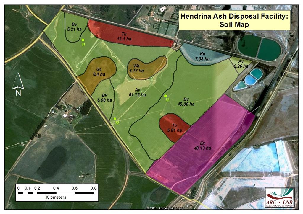
3 1 INTRODUCTION 1.1 Terms of Reference The ARC-Institute for Soil, Climate and Water (ARC-ISCW) was requested by Lidwala Environmental and Planning Services to carry out a soil survey in the vicinity of Hendrina Power Station in Mpumalanga Province. The aim of the survey was to describe, classify and map the soils occurring in the area of the proposed ash disposal facility, and to assess the agricultural potential. Soil samples were collected for verification purposes. Google Earth images and 1: scale topo-cadastral maps were used to create a base map for the survey. 2 STUDY AREA 2.1 Location The study area (Figure 1, yellow boundary) is located immediately to the south of the Hendrina Power Station at Pullen s Hope. Figure 1: Location Map HENDRINA 3
4 The area lies between latitudes 26 o and 26 o S and between longitudes 29 o and 29 o E. 2.2 Site Details The site is just over 208 ha in extent, and lies between and metres above sea level, with the highest point in the south-east. The terrain falls gently to the north, with slopes of between 2% and 5%. Most parts of the site show that it was previously or is presently being cultivated. However, in the south-eastern corner there is a portion (+48 ha) that comprises disturbed soils due to excavation. There is an abandoned dwelling in the northern part (south of the power station). 2.3 Climate Climate data was obtained from the national Land Type Survey (Kotzé, 1985). The climate has warm, moist summers with cool, dry winters. On average, 85% of the annual average rainfall of mm falls in the growing season (October to March). Frost, often severe, occurs in winter. The extreme maximum temperature is 35.6 o C and the extreme minimum 11.1 o C The climatic data is given in Table 1 below. Table 1 Month Climate Data for Hendrina area Rainfall Min. Temp Max. (mm) ( o C) Temp ( o C) Average frost dates Jan Start date: 06/01 Feb End date: 11/11 Mar Days with frost: +46 Apr May Jun Jul Heat units (hrs > 10 o C) Aug Summer (Oct-Mar): Sep Oct Winter (Apr-Sept): Nov Dec Year (Average) 14.9 o C 2.4 Geology The geology of the study area consists of sandstone and shale of the Vryheid Formation, of the Karoo Sequence (Geological Survey, 1986). 4
5 3 METHODOLOGY The soils were investigated using a hand-held soil auger to a maximum depth of mm, on a grid of 150 x 150 metres, which was established using a GPS. All the relevant soil properties (horizons, colour, structure, texture, calcareousness, drainage, etc) at each observation point were noted and the soils were classified according to the South African Soil Classification System (Soil Classification Working Group, 1991). Similar soils were grouped together into mapping units. Representative topsoil and subsoil samples were collected from three sites within the areas for laboratory analysis (marked S1 to S3 on the soil map in the Appendix). The samples were analysed for particle size (sand, silt and clay), ph( H2O ), cation exchange capacity (CEC) and exchangeable cations, organic carbon and P (Bray 1) according to the standard prescribed methods (Non-Affiliated Soil Analysis Work Committee, 1990). 4 RESULTS 4.1 Soils Several soil map units were identified. A description of the most important soil characteristics of each unit, such as the dominant soil form and family, soil depth, topsoil texture and underlying material, is given in the soil legend shown in Table 2. The colours used correspond to those shown on the soil map (Appendix). In general, the soils are moderately deep, yellow-brown to red, light- to medium-textured soils (Av, Bv and Gc map units), with no significant degree of structure. Shallower soils, with ferricrete outcrops in places, also occur (Wa map unit), as well as some areas of disturbance (Ex map unit). The soils in the lower-lying positions (Tu and Ka map units) are darker brown to black, with a slightly heavier texture and signs of wetness lower in the profile. The map units are shown on the soil map in the Appendix as for the following example: Av ha Where Av represents the map unit (in this case Avalon soils) and ha is the area. 4.2 Soil Analysis Results Samples of topsoil and subsoil were collected at three localities (S1 to S3). These points are marked on the soil map (Appendix). The analysis results are shown in Table 3. 5
6 Table 2 Soil map legend Map Unit Depth (mm) Av Bv Gc Wa Tu Ka Dominant Soil Form(s) Sub-dominant Soil Form(s) General description of soils occurring Structureless soils Avalon Glencoe Grey-brown, structureless, loamy sand to sandy loam topsoils on yellow-brown, structureless, loamy sand to sandy loam subsoils on grey, mottled, soft plinthite (Avalon form) or occasionally on cemented ferricrete (Glencoe form). Bainsvlei Hutton Reddish, structureless, sandy loam topsoils on red, structureless, sandy loam to sandy clay loam subsoils on grey mottled, soft plinthite (Bainsvlei form). Where no plinthite is present, the soils belong to the Hutton form. Glencoe Glenrosa, Avalon Grey-brown, structureless, loamy sand to sandy loam topsoils on yellow-brown, structureless, loamy sand to sandy loam subsoils on cemented ferricrete (Glencoe form). Wasbank Dresden Grey-brown, structureless to weakly structured, sandy loam topsoils on greyish, structureless, sandy loam subsoils, on hard plinthic (Wasbank form). Where grey subsoil horizon is absent, the soils belong to the Dresden form. Soils with signs of wetness Tukulu Avalon Dark brown, structureless to weakly structured, sandy loam to sandy clay loam topsoils on yellow-brown to dark grey, weakly structured, mottled, sandy clay loam subsoils, on grey, mottled clay (Tukulu form), occasionally on grey, mottled, soft plinthite (Avalon form). Katspruit - Brown to dark brown, weakly structured, sandy clay loam topsoils on dark brown to dark grey-black, weakly structured, sandy clay loam subsoils, often wet (Katspruit form). Miscellaneous Ex Much topsoil removed through excavation, signs of red deep soils, but much mixing and disturbance Agricultural Potential Moderate to high (63.98 ha) Moderate to high (56.37 ha) Low to moderate (8.40 ha) Low to moderate (6.17 ha) Low (17.91 ha) Very low (7.08 ha) Very low (48.13 ha) TOTAL AREA ha
7 Table 3 Soil analysis results Sample site S1 S2 S3 Co-ordinates (Lat/Long) 26 o o o o o o Soil Form Avalon Avalon Bainsvlei Horizon A1 B1 A1 B1 A1 B1 Depth (mm) Sa Si % Cl Na K Ca cmol kg Mg CEC P (ppm) ph (H 2 O) Org C (%)
8 The soil analysis results show the light texture of the yellow-brown (Av) soils, with the red (Bv) soils being slightly higher in clay. The soils are not highly leached (eutrophic), with ph levels being neutral to slightly acidic. S1 and S2 were cultivated sites, where the lower organic carbon levels and higher residual P fertilization contrast with the uncultivated site S3. However, in general, these are fertile, productive soils, and no abnormal or unexpected values were observed. 4.3 Agricultural Potential The general agricultural potential class of each map unit, and the main limiting factors, are given in Table 4 below. Table 4 Agricultural Potential Agricultural Potential Moderate to high Map unit Av, Bv Limitations Few limitations. Moderately deep to deep, friable soils. Underlying plinthite may occur at shallow depth in places Restricted depth to underlying plinthite in many areas. Reduced natural fertility Area (ha) Low to moderate Wa, Gc Low Tu Occasional subsoil wetness and flood hazard (Wetland) Very Low Ka Almost continuous subsoil wetness and flood 7.08 hazard (Ka) (Wetland) Very Low Ex Soil has been disturbed with topsoil removal (Ex) From Table 4, it can be seen that most of the survey area comprises soils with moderate to high agricultural potential (Bv and Av map units); the soils are deep and freely drained, with few limitations, and climatic conditions for rain-fed cultivation are generally good, with sufficient rainfall (Section 2.3). Both the Tu and the Ka unit comprise wetlands (the Tu unit is a temporary wetland, while the Ka unit is a permanent wetland), and these should, as far as possible be left undisturbed The Ex map unit comprises areas where excavations have occurred. In some instances, there has been replacement of topsoil, but there are also significant areas where the excavation has been left with very little topsoil, and in some cases with the ferricrete outcropping at the surface. Due to the uneven distribution of these areas, the increased compaction of the soils in places and the subsequent significant reduction in available soil depth, this map unit is difficult to describe or classify and has a very low potential for agriculture.
9 REFERENCES Geological Survey, : scale Geological Map of 2630 Mbabane. Department of Mineral and Energy Affairs, Pretoria. Kotze, A.V., Climate data. In: Land types of the maps 2628 East Rand and 2630 Mbabane. Mem. Agric. Nat. Res. S. Afr. No 5. Dept. Agric & Water Supply, Pretoria. Non Affiliated Soil Analysis Work Committee, Handbook of standard soil testing methods for advisory purposes. Soil Science Society of South Africa, Pretoria. Soil Classification Working Group, Soil classification. A taxonomic system for South Africa. Institute for Soil, Climate & Water, Pretoria. 9
10 Appendix: Soil Map 10
11 11
SOIL SURVEY OF PORTIONS 81 AND 82 OFTHE FARM VAALBANK 512JQ, NEAR MAGALIESBURG, SOUTH-WEST OF PRETORIA
 REPORT For Newtown Landscape Architects SOIL SURVEY OF PORTIONS 81 AND 82 OFTHE FARM VAALBANK 512JQ, NEAR MAGALIESBURG, SOUTH-WEST OF PRETORIA By N.M. Mushia, D.G. Paterson and S.D. Mkula Report Number
SOILS AND AGRICULTURAL POTENTIAL FOR THE PROPOSED P166 SERVITUDE, MBOMBELA, MPUMALANGA PROVINCE
 REPORT On contract research for Royal Haskoning DHV SOILS AND AGRICULTURAL POTENTIAL FOR THE PROPOSED P166 SERVITUDE, MBOMBELA, MPUMALANGA PROVINCE By F.T. Seabi (Pr. Nat. Sci. 400370/11) & D.G. Paterson
SCOPING REPORT. On contract research for ILISO CONSULTING
 SCOPING REPORT On contract research for ILISO CONSULTING Proposed Construction of a 65 MW Photovoltaic Power Plant, Duvha Power Station, Mpumalanga Province Soils and Agricultural Potential Scoping Study
The entire site supports grass on which sheep had been grazing recently.
 PHYSICAL CHARACTERISTICS REPORT FOR LAND AT HORSEHAY A^ Agricultural Land Classification of approximately 14 hectares of land to the southwest of Horsehay was undertaken in November 1989. The site lies
STATEMENT OF PHYSICAL CHARACTERISTICS AND AGRICULTURAL LAND CLASSIFICATION
 STATEMENT OF PHYSICAL CHARACTERISTICS AND AGRICULTURAL LAND CLASSIFICATION BIRKWOOD FARM, ALTOFTS WEST YORKSHIRE Proposed Opencast Extraction of Clay and coal ADAS January 1990 Leeds Regional Office File
PROPOSED OPEN CAST COAL SITE SEPTEMBER 1992
 AGRICULTURAL LAND CLASSIFICATION AND STATEMENT OF PHYSICAL CHARACTERISTICS SKIERS SPRING, HOYLAND, SOUTH YORKSHIRE PROPOSED OPEN CAST COAL SITE SEPTEMBER 1992 ADAS LEEDS STATUTORY GROUP Job No. 98/92 MAFF
AGRICULTURAL LAND CLASSIFICATION AND STATEMENT OF PHYSICAL CHARACTERISTICS
 AGRICULTURAL LAND CLASSIFICATION AND STATEMENT OF PHYSICAL CHARACTERISTICS DALE PIT FARM. HATFIELD VOODHOUSE PROPOSED EXTRACTION OF SAND AHD GRAVEL ADAS April 1989 Leeds Regional office File Ref: 2FCS
PHYSICAL CHAtlACTERISTICS REPORT FOR THE PROPOSED SAND AND GRAVEL SITE AT MANOR FARM, UFFINGTON
 PHYSICAL CHAtlACTERISTICS REPORT FOR THE PROPOSED SAND AND GRAVEL SITE AT MANOR FARM, UFFINGTON Introduction Following the" request for detailed information on the physical characteristics of soil at Manor
STATEMENT OF PHYSICAL CHARACTERISTICS AND AGRICULTURAL LAND CLASSIFICATION WITTON PARK, COUNTY DURHAM PROPOSED QUARRY EXTENSION DECEMBER 1992

PHYSICAL CHARACTERISTICS REPORT INCORPORATING AGRICULTURAL LAND CLASSIFICATION LAND AT BOLE INGS, WESTBURTON, NOTTINGHAMSHIRE (SK805875)
") (krahs 2% I?5 PHYSICAL CHARACTERISTICS REPORT INCORPORATING AGRICULTURAL LAND CLASSIFICATION LAND AT BOLE INGS, WESTBURTON, NOTTINGHAMSHIRE (SK805875) 1.0 INTRODUCTION 1.1 The site, an area of 84.5 hectares,
(krahs 2% I?5 PHYSICAL CHARACTERISTICS REPORT INCORPORATING AGRICULTURAL LAND CLASSIFICATION LAND AT BOLE INGS, WESTBURTON, NOTTINGHAMSHIRE (SK805875) 1.0 INTRODUCTION 1.1 The site, an area of 84.5 hectares,
Report on a soil survey and agricultural suitability investigation of the property known as Erf 660, De Doorns.
 De Doorns erf 660 Soil Report 1 Report on a soil survey and agricultural suitability investigation of the property known as Erf 660, De Doorns. by F. Ellis September 2006 CONTENTS 1 INTRODUCTION AND TERMS
AGRICULTURAL LAND CLASSIFICATION AND SOIL PHYSICAL CHARACTERISTICS BIRCH PIT, NEAR COLCHESTER ESSEX
 AGRICULTURAL LAND CLASSIFICATION AND SOIL PHYSICAL CHARACTERISTICS BIRCH PIT, NEAR COLCHESTER ESSEX AGRICULTURAL LAND CLASSIFICATION AND SOIL PHYSICAL CHARACTERISTICS SEMI-DETAILED SURVEY BIRCH PIT, NEAR
AGRICULTURAL LAND CLASSIFICATION AND STATEMENT OF PHYSICAL CHARACTERISTICS
 AGRICULTURAL LAND CLASSIFICATION AND STATEMENT OF PHYSICAL CHARACTERISTICS SEGHILL, NORTHUMBERLAND PROPOSED VASTE DISPOSAL SITE ADAS January 1989 Leeds Regional Office REF: 3/89 2FCS 4191 lds.rpg3.seghill
HUMBLEBURN OCCS, CRAGHEAD, COUNTY DURHAM SURVEY OF RESTORED LAND OCTOBER RPT Job Number: 73/97 MAFF Reference: EL LURET Job Number: ME3RTP
 HUMBLEBURN OCCS, CRAGHEAD, COUNTY DURHAM SURVEY OF RESTORED LAND OCTOBER 1997 Resource Planning Team Northern Region FRCA, Leeds RPT Job Number: 73/97 MAFF Reference: EL 10387 LURET Job Number: ME3RTP
SOILS AND AGRICULTURAL USE & QUALITY OF LAND OFF HOLT ROAD, ROSSETT. Report 1067/1
 SOILS AND AGRICULTURAL USE & QUALITY OF LAND OFF HOLT ROAD, ROSSETT Report 1067/1 2 nd March, 2015 SOILS AND AGRICULTURAL USE AND QUALITY OF LAND OFF HOLT ROAD, ROSSETT M W Palmer, MSc, PhD, MISoilSci
2012 FINAL SOILS AREA 2 Envirothon Questions Answer KEY
 2012 FINAL SOILS AREA 2 Envirothon Questions Answer KEY Questions 1-6 to be answered at the soil pit: 1. Soil scientists categorize soils by drainage classes. What is the drainage class of the soil at
6 Athlone Street Tel: SWELLENDAM Cell:
 C R LUBBE 6 Athlone Street Tel: 028 514 2359 SWELLENDAM Cell: 082 853 1274 6740 e-mail: macquarrie@vodamail.co.za Attention: Louise Mari van Zyl Cape EA Prac 1 June 2018 P O Box 2070 GEORGE 6530 Dear Ms
MAFF Ministry of Ifinil Agriculture Rsheries and Food
 MAFF Ministry of Ifinil Agriculture Rsheries and Food STATEMENT OF PHYSICAL CHARACTERISTICS AND AGRICULTURAL LAND CLASSIFICATION SHILBOTTLE COLLIERY RECLAMATION SCHEME NORTHUMBERLAND DECEMBER 1994 ADAS
ACRE NOOK EAST QUARRY, CHELFORD, CHESHIRE. Statement of Site Physical Characteristics January 1998
 ACRE NOOK EAST QUARRY, CHELFORD, CHESHIRE Statement of Site Physical Characteristics January 1998 J M LePage Resource Planning Team RPT Reference: 084/97 & 25/RPT/0863 Northern Region FRCA Reference: EL
AGRICULTURAL LAND CLASSIFICATION AND SOIL PHYSICAL CHARACTERISTICS LAND NEAR SHIRE HILL FARM SAFFRON WALDEN ESSEX
 AGRICULTURAL LAND CLASSIFICATION AND SOIL PHYSICAL CHARACTERISTICS LAND NEAR SHIRE HILL FARM SAFFRON WALDEN ESSEX AGRICULTURAL LAND CLASSIFICATION (ALC) AND SOIL PHYSICAL CHARACTERISTICS LAND NEAR SHIRE
AGRICULTURAL USE & QUALITY OF LAND NEAR MINDALE HOUSE PRESTATYN. Report 762/1
 AGRICULTURAL USE & QUALITY OF LAND NEAR MINDALE HOUSE PRESTATYN Report 762/1 11 th April, 2012 AGRICULTURAL USE & QUALITY OF LAND NEAR MINDALE HOUSE PRESTATYN F W Heaven, BSc, MISoilSci Report 762/1 Ltd
Agricultural Land Classification and Statement of Physical Characteristics Higbfield Farm Whitley Bridge North Yorkshire October 1996
 Agricultural Land Classification and Statement of Physical Characteristics Higbfield Farm Whitley Bridge North Yorkshire October 1996 Resource Planning Team ADAS Reference: 82/96 Leeds Statutory Group
CB1 Moderately undulating landscape with slight gilgai (few inches) formation: broad ridge tops and upper slopes of moderately shallow grey cracking
 formation: broad ridge tops and upper slopes of moderately shallow grey cracking") CB1 Moderately undulating landscape with slight gilgai (few inches) formation: broad ridge tops and upper slopes of moderately shallow grey cracking clays (Ug5.22 and Ug5.23). Associated are: (i) some
CB1 Moderately undulating landscape with slight gilgai (few inches) formation: broad ridge tops and upper slopes of moderately shallow grey cracking clays (Ug5.22 and Ug5.23). Associated are: (i) some
AGRICULTURAL LAND CLASSIFICATION
 AGRICULTURAL LAND CLASSIFICATION GOOLE/HOOK LOCAL PLAN SITES SURVEYED FOR BOOTHFERRY BOROUGH COUNCIL'S INDUSTRIAL LAND SUITABILITY STUDY ADAS February 1991 Leeds Regional Office 2FCS 5205 CONTENTS 1. Introduction
Soil Horizons cont. Oa- highly decomposed Oi-undecomposed
 Soils Soil Basics Soil Horizons Soil Horizons cont. O Horizon: Or organic layer Organic layer of decomposing plant and animal tissue. Wooded upland areas have thin O horizons Wetlands may have thick O
P/2014/00830 Received 27/06/2014 SOIL RESOURCES AND AGRICULTURAL USE & QUALITY OF LAND AT ROLLESTON PARK FARM TUTBURY, STAFFORDSHIRE.
 P/2014/00830 Received 27/06/2014 SOIL RESOURCES AND AGRICULTURAL USE & QUALITY OF LAND AT ROLLESTON PARK FARM TUTBURY, STAFFORDSHIRE Report 953/1 28 th May, 2014 SOIL RESOURCES AND AGRICULTURAL USE & QUALITY
SOIL DATA: Avondale. in Allen, TX. This information was taken from NRCS web soil survey of Collin County, Texas.
 SOIL DATA: Avondale in Allen, TX This information was taken from NRCS web soil survey of Collin County, Texas. United States Department of Agriculture Soil Conservation Service in cooperation with Texas
 Cci
Cci Soil 1/18/2012. Soils, Nutrients and Fertilizers Part I. Soil Profile
 Soils, Nutrients and Fertilizers Part I Handouts: Soil Texture Triangle ph Nutrient Availability Soil Diverse combination of weathered rock fragments and minerals, with decaying remains of plants and animals
2014 Iowa FFA Soil Judging CDE Exam
 2014 Iowa FFA Soil Judging CDE Exam 1. Landscape position is one aspect of evaluating the surface features of a certain tract of land. Identifying the correct landscape position will indicate: a. If the
Environmental Impact Assessment for KPSX: Weltevreden
 Environmental Impact Assessment for KPSX: Weltevreden Soil Survey Report Project Number: Prepared for: Billiton Energy Coal South Africa (PTY) Limited (BECSA) January 2015 Digby Wells and Associates (South
Saline and Sodic Field Demonstration project
 Saline and Sodic Field Demonstration project 2007-2013 Tile drainage will help decrease the soluble salt level over time but does not address parts of the field that have sodium issues as well. Reclamation
Do Now: From which materials do you think soil is made? Are all soils the same? Think of some ways that they are different?
 Do Now: From which materials do you think soil is made? Are all soils the same? Think of some ways that they are different? Basics Soil is a major component of the biosphere It contains solids, liquids
Kenya Agricultural Research Institute Kenya Soil Survey P.O. Box Tel: /
 Kenya Agricultural Research Institute Kenya Soil Survey P.O. Box 14733-00800 Tel: 4443376/4440903 E-mail - kss@iconnect.co.ke NAIROBI THE SOIL CONDITIONS OF SIX EXPERIMENTAL SITES IN MACHANG A, EMBU, KIREGE,
 108 40' 29'' W Soil Map Mesa County Area, Colorado 108 36' 55'' W 39 10' 11'' N 39 6' 31'' N 4331700 4332500 4333300 4334100 4334900 4335700 4336500 4337300 4338100 701100 701900 702700 703500 704300 705100
CAVIL HEAD OCCS ACKLINGTON NOVEMBER 1997
 CAVIL HEAD OCCS ACKLINGTON Agricultural Land Classification (ALC) and Statement of Physical Characteristics Report NOVEMBER 1997 Resource Planning Team RPT Job Number: 67/97 Northern Region MAFF Reference:
Topoclimate Southland Soil Technical Data Sheet No Waiau
 This Technical Data Sheet describes the typical average properties of the specified soil. It is essentially a summary of information obtained from one or more profiles of this soil that were examined and
Pistachio Project Planning, Irrigation Systems and Irrigation Management. Trevor Sluggett Irrigation Agronomist AgriExchange Pty Ltd
 Pistachio Project Planning, Irrigation Systems and Irrigation Management Trevor Sluggett Irrigation Agronomist AgriExchange Pty Ltd Excited About Pistachios A nut crop other than Almonds Good demand for
Iowa FFA Soil Career Development Event 2008
 Iowa FFA Soil Career Development Event 2008 1. In Iowa, corn suitability ratings for soil mapping units specifies a. natural weather conditions b. surface and subsurface drainage installed where needed
AGRICULTURAL LAND CLASSIFICATION AND STATEMENT OF SOIL PHYSICAL CHARACTERISTICS EXTENSION TO CLOUD HILL QUARRY, BREEDON ON THE HILL, LEICESTERSHIRE
 AGRICULTURAL LAND CLASSIFICATION AND STATEMENT OF SOIL PHYSICAL CHARACTERISTICS EXTENSION TO CLOUD HILL QUARRY, BREEDON ON THE HILL, LEICESTERSHIRE 1.0 BACKGROUND 1.1 A site of approximately 14.5 ha in
SOIL CHARACTERIZATION USING DIAGNOSTIC PROPERTIES
 SOIL CHARACTERIZATION USING DIAGNOSTIC PROPERTIES The following are the characters of the pedologically important properties used in categorizing soils: SOIL CHARACTERIZATION Soil Profile Description:
Topoclimate Southland Soil Technical Data Sheet No. 8. Sobig
 This Technical Data Sheet describes the typical average properties of the specified soil. It is essentially a summary of information obtained from one or more profiles of this soil that were examined and
PASTURE AND HAY FIELDS: SOIL FUNDAMENTALS. Sanders County April 8, Clain Jones
 PASTURE AND HAY FIELDS: SOIL FUNDAMENTALS Sanders County April 8, 2015 Clain Jones clainj@montana.edu 994-6076 Objectives Present soil properties and how they interact with plant nutrients Illustrate the
Muswellbrook Coal Company No.1 Open Cut Extension Soil Study
 Muswellbrook Coal Company No.1 Open Cut Extension Soil Study November 2001 Table of Contents 1. Introduction... 1 2. Methodology... 1 3. Description of Soil Units Observed... 2 3.1 Yellow Duplex Soils
Scientific registration no : 43 Symposium no : 27 Presentation : poster. GOBRAN Omar 1), EL-BARBARY Serry 2)
, EL-BARBARY Serry 2)") Scientific registration no : 43 Symposium no : 27 Presentation : poster Morphological Changes of Newly Reclaimed Soils In Egypt Cultivated For Different Periods Modifications morphologiques au cours du
Scientific registration no : 43 Symposium no : 27 Presentation : poster Morphological Changes of Newly Reclaimed Soils In Egypt Cultivated For Different Periods Modifications morphologiques au cours du
REPORT. Soil, Land Capability and Land Use Assessment Report for the Proposed New Vaal Colliery Life Extension Project.
 Rehab Green cc Registration No: 2002/094339/23 PI Steenekamp PO Box 12636 Queenswood 0121 Pretoria Cell: 082 560 0592 Fax: 086 678 1690 E-mail: rehabgreen@ee-sa.com Report No: RG/2012/03/09/1 Date: 30
SUMMARY. alcholnie.doc\ih\jk
 SUMMARY A detailed Statement of Physical Characteristics and Agricultural Land Classification survey of ha of land at Stainton ("Holme Hall Quarry Extension") was carried out in September 1994. At the
STAFFORDSHIRE AND STOKE-ON- TRENT STRUCTURE PLAN Site 7: Priory Farm. Agricultural Land Classification ALC Map and Report November 1998
 STAFFORDSHIRE AND STOKE-ON- TRENT STRUCTURE PLAN Site 7: Priory Farm Agricultural Land Classification ALC Map and Report November 1998 A J Spalding Resource Planning Team RPT Reference: 008/98 & 25/RPT/Ol
AGRICULTURAL LAND CLASSIFICATION REPORT LAND AT BRANT FARM, STOURPORT-ON-SEVERN
 AGRICULTURAL LAND CLASSIFICATION REPORT LAND AT BRANT FARM, STOURPORT-ON-SEVERN INTRODUCTION 1. This report presents the findings of a detailed Agricultural Land Classification (ALC) survey on 12ha of
2016 Area 3 Envirothon Muskingum County Soils Test ANSWER KEY
 2016 Area 3 Envirothon Muskingum County Soils Test ANSWER KEY 1. The majority of the bedrock in Muskingum County is. a. sedimentary bedrock b. glacial bedrock c. igneous bedrock d. metamorphic bedrock
If A rr Ministry of. IfiriEI. Agriculture Fisheries and Food
 If A rr Ministry of IfiriEI. Agriculture Fisheries and Food AGRJCULTURAL LAND CLASSIFICATION CLEETHORPES DISTRICT LOCAL PLAN SITE H2 (SOUTH WEST) OCTOBER 1993 ADAS Leeds Statutory Group Job No:- 164/93
3.44b. Soil Classification AK & BR
 3.44b Soil Classification AK & BR Why look at soil? Because soil and its constituents are the base material for growing trees. History Why a Forestry Commission soil classification? There is a need for
2 Older farm homes on the land
 2 Older farm homes on the land LAND RANCHES EXCHANGES This ranch consists of 70 +/_ acres of level farmland. Prime 13700 POWERHOUSE RD POTTER VALLEY agricultural land at an attractive price. This property
HAVE YOU NOTICED at construction sites how a
 Explaining a Soil Profile HAVE YOU NOTICED at construction sites how a cross section of soil has a layered look? Soil near the top of the cross section is often dark, and soil below appears lighter. What
Terminology & Soil Science. Andy Spetch
 Terminology & Soil Science Andy Spetch 1 Presentation Soil Profile Soil Structure Soil Texture Compaction Cation Exchange Capacity Soil ph Nutrients / Organic Matter / EC / PTE s 2 What is Soil: A blend
3. What are the five master horizons? Give distinguishing features of each. 5. List three means by which plant roots come into contact with nutrients.
 Study Questions Exam 1 1. What are the four general components of soil? 2. Define regolith and solum. 3. What are the five master horizons? Give distinguishing features of each. 4. What is meant by an
STATEMENT OF PHYSICAL CHARACTERISTICS OLDWICK FARM, WEST LAVANT, WEST SUSSEX
 STATEMENT OF PHYSICAL CHARACTERISTICS OLDWICK FARM, WEST LAVANT, WEST SUSSEX STATEMENT OF PHYSICAL CHARACTERISTICS OLDWICK FARM, WEST LAVANT, WEST SUSSEX 1. BACKGROUND 1.1 This 37.1 ha site was surveyed
27/01/2017. This event is being run by SAC Consulting. What is Soil?
 This event is being run by SAC Consulting What is Soil? 1 Soil Texture It describes the physical composition of the soil % of sand, silt and clay Refers to the mineral fragments of the soil only water
Tools to facilitate the use of Soil Maps in Emilia-Romagna region (Italy) Paola Tarocco
 Paola Tarocco") Tools to facilitate the use of Soil Maps in Emilia-Romagna region (Italy) Paola Tarocco Soil maps Vs Thematic maps Soil maps are not easy to manage. Legends are usually based on soil classifications (e.g.
Tools to facilitate the use of Soil Maps in Emilia-Romagna region (Italy) Paola Tarocco Soil maps Vs Thematic maps Soil maps are not easy to manage. Legends are usually based on soil classifications (e.g.
Lesson 1: Recognizing the Characteristics of Soils and the Soil Requirements for Fruit and Nut Crops
 Lesson 1: Recognizing the Characteristics of Soils and the Soil Requirements for Fruit and Nut Crops 1 Mineral matter Organic matter Pore spaces Tilth Hygroscopic water Soil aeration 22 I. Soil is a layer
Grade. % of Survey Area 1. Staplehay. 2 3a. 3a 3b Non Ag Organ Ag Bldgs. 1 Non Ag Urban
 ^ ( ^ ^fcj 2JiOc^ TAUNTON LOCAL PUW FIRST ALTE31ATI0N AOtECULTURAL LAND CLASSIFICATION OF ALTERNATIVE SITES R^»rt of Survey 1. Introduction Agricultural Land Classification surveys were carried out at
HORT 102: Soil Properties. Cultivated Plants: Lecture 15. [Teresa Koenig] Slide #: 1 Slide Title: Intro Information Slide
![HORT 102: Soil Properties. Cultivated Plants: Lecture 15. [Teresa Koenig] Slide #: 1 Slide Title: Intro Information Slide](/thumbs/76/74082590.jpg "HORT 102: Soil Properties. Cultivated Plants: Lecture 15. [Teresa Koenig] Slide #: 1 Slide Title: Intro Information Slide") HORT 102: Soil Properties Cultivated Plants: Lecture 15 [Teresa Koenig] Slide #: 1 Slide Title: Intro Information Slide Title: Lecture 15 Soil Properties Speaker: Teresa Koenig Created by: Teresa Koenig,
HORT 102: Soil Properties Cultivated Plants: Lecture 15 [Teresa Koenig] Slide #: 1 Slide Title: Intro Information Slide Title: Lecture 15 Soil Properties Speaker: Teresa Koenig Created by: Teresa Koenig,
Girtridge Monitor Farm Meeting
 Girtridge Monitor Farm Meeting 15 th August 2018 1 Managing Soil Drainage and Compaction in Pasture Key factors for movement of water in the soil Soil Texture Soil Structure Soil Compaction 2 1 Soil Texture
IOWA FFA STATE SOILS CDE SATURDAY, OCTOBER 13, 2007 AMES, IOWA
 IOWA FFA STATE SOILS CDE SATURDAY, OCTOBER 13, 2007 AMES, IOWA 1. Moderately sloping has what percent slope: a. 9-14% b. 2-5% c. 5-9% d. over 14% 2. Which of the following horizons is the loose underlying
AGRICULTURAL LAND CLASSIFICATION AND STATEMENT OF SOIL PHYSICAL CHARACTERISTICS TYTTENHANGER QUARRY EXTENSION, LONDON COLNEY, HERTFORDSHIRE
 AGRICULTURAL LAND CLASSIFICATION AND STATEMENT OF SOIL PHYSICAL CHARACTERISTICS TYTTENHANGER QUARRY EXTENSION, LONDON COLNEY, HERTFORDSHIRE 1.0 BACKGROUND 1.1 The site covers an area of 42.2 ha, and is
CORNFORTH EAST QUARRY COUNTY DURHAM
 CORNFORTH EAST QUARRY COUNTY DURHAM AgricuUural Land Classification (ALC) and Statement of Physical Characteristics Report and Map MARCH 1999 Resource Planning Team RPT Job Number: 5/99 Northern Region
Examining soils in the field. Examining soils in the field. Environment Agency thinksoils examining soils in the field
 Examining soils in the field thinksoils Examining soils in the field Environment Agency thinksoils examining soils in the field 31 Examining soils in the field 32 Environment Agency thinksoils examining
Topoclimate Southland Soil Technical Data Sheet No. 76. Mossburn
 This Technical Data Sheet describes the typical average properties of the specified soil. It is essentially a summary of information obtained from one or more profiles of this soil that were examined and
Investigation into soil texture in my area
 Aim Investigation into soil texture in my area The aim of my investigation is to calculate how much sand, silt and clay is present in a sample of soil from my garden and to compare it with a sample taken
AGRICULTURAL LAND CLASSIFICATION KNOWSLEY UDP, SITE 45.01
 AGRICULTURAL LAND CLASSIFICATION KNOWSLEY UDP, SITE 45.01 MJW WOOD ADAS Ref: 25/RPT/OOll Resource Planning Team Job No: 016/95 ADAS Statutory Group MAFF Ref: EL 25/10763 WOLVERHAMPTON rnwtaiow2to»yyje
AGRICULTURAL LAND CLASSIFICATION
 AGRICULTURAL LAND CLASSIFICATION STAINSBY HALL, MIDDLESBROUGH PROPOSED GOLF COURSE ADAS December 1990 Leeds Regional Office 2FCS 5100 CONTENTS 1. INTRODUCTION AND GENERAL SITE CHARACTERISTICS 2. AGRICULTURAL
ASCE - Philadelphia. Soils & Stormwater Management. Matthew C. Hostrander, CPSS, SEO Soil Scientist. Gilmore & Associates, Inc.
 ASCE - Philadelphia Soils & Stormwater Management Matthew C. Hostrander, CPSS, SEO Soil Scientist Gilmore & Associates, Inc. Course Overview COURSE OUTLINE Soil Science Fundamentals Discuss United States
INEEL (1500) [45] 5.6 C 217 mm 60. Precipitation (mm) Temperature (oc) Month
![INEEL (1500) [45] 5.6 C 217 mm 60. Precipitation (mm) Temperature (oc) Month](/thumbs/91/105194910.jpg "INEEL (1500) [45] 5.6 C 217 mm 60. Precipitation (mm) Temperature (oc) Month") Figure 1. Water balance of a vegetated plot. Plants extract water from throughout the soil profile, to depths that may exceed 2 m in deep soils. In contrast, most water lost by direct evaporation comes
Figure 1. Water balance of a vegetated plot. Plants extract water from throughout the soil profile, to depths that may exceed 2 m in deep soils. In contrast, most water lost by direct evaporation comes
Soil characteristics that influence nitrogen and water management
 Section C Soil characteristics that influence nitrogen and water management Soil characteristics vary across the landscape Soils vary from one field to another, and often within the same field. Soil differences
Soils and the Environment. A Summary of RI Envirothon Study Materials Compiled by Sally Paul
 Soils and the Environment A Summary of RI Envirothon Study Materials Compiled by Sally Paul Why Soils Food and water resources Disposing of waste Support for human structures Growing timber and fibers
LAND NORTH OF TAMWORTH. Agricultural Land Classification ALC Map and Report April 1998
 LAND NORTH OF TAMWORTH Agricultural Land Classification ALC Map and Report April 1998 A,L Cooke Resource Planning Team RPT Reference: 130/97 & 25/RPT/Ol loa Northern Region FRCA Reference: EL 37/11747
The Dirt on Soil Science
 The Dirt on Soil Science Dr. Laura Deeter deeter.7@osu.edu Ohio State ATI 1 Rough Outline Basic Michigan soil history Soil Basics What is soil Soil texture/particles ph Plant nutrients Organic Matter 2
Annex 5D. Soil, Land Use and Land Capability Report compiled by TerraAfrica Consult, April 2015
 Annex 5D Soil, Land Use and Land Capability Report compiled by TerraAfrica Consult, April 2015 Environmental Assessment Report for the Kangra Coal (Pty) Ltd Kusipongo Resource Project: I, Mariné Pienaar,
NOT PROTECTIVELY MARKED SUB-APPENDIX A2: SOIL ANALYTICAL SUITES
 SUB-APPENDIX A2: SOIL ANALYTICAL SUITES A2.1.1 There will be three soil analytical suites summarised in Table 3 in the text. Details of the analyses to be carried out in each suite and the methodologies
DO YOU KNOW YOUR SOILS? (Rev. 10/11)
") DO YOU KNOW YOUR SOILS? (Rev. 10/11) Circle all the correct answers. 1. What is the layer normally present on the surface of the soil in cropped fields? a. O c. Ap e. B g. R b. A d. E f. C 2. Available
DO YOU KNOW YOUR SOILS? (Rev. 10/11) Circle all the correct answers. 1. What is the layer normally present on the surface of the soil in cropped fields? a. O c. Ap e. B g. R b. A d. E f. C 2. Available
CLAY, SANDY AND PEAT SOILS, AND SOIL ORGANIC MATTER
 CLAY, SANDY AND PEAT SOILS, AND SOIL ORGANIC MATTER Background Most normal soils ( mineral soils ) consist of tiny particles of rock that have been broken into small pieces by such things as wind, water,
The Nature of Soil Soil Conservation Sustainable Ag.
 Chapter 6 & 7 The Nature of Soil Soil Conservation Sustainable Ag. Climate Soil Forming Factors Parent material Organisms Topography Time Value of Soil Soil is under appreciated Condition of soil affects
Soil Interpretations Erosion and Sedimentation Control Planning and Design Workshop
 Soil Interpretations Erosion and Sedimentation Control Planning and Design Workshop Presented by Richard Brooks Presentation prepared by Kristin May Resource Soil Scientists USDA-Natural Resources Conservation
STATEMENT OF PHYSICAL CHARACTERISTICS AND AGRICULTURAL LAND CLASSIFICATION
 STATEMENT OF PHYSICAL CHARACTERISTICS AND AGRICULTURAL LAND CLASSIFICATION DRAX AND BARLOV: Proposed Waste (PFA) disposal and Industrial development site ADAS MAY 1989 LEEDS REGIONAL OFFICE FILE REF: 2FCS
SITE TOPSOIL & FINISH GRADING
 CITY OF BRAMPTON LANDSCAPE SPECIFICATIONS SECTION 02911-1 PART 1 GENERAL 1.1 Related Work.1 Section 02311 Site Grading.2 Section 02315 Excavating, Trenching, & Backfilling.3 Section 02906 Planting of Trees,
SOIL SURVEY REPORT ON SENCE de LIEU, PAARL
 SOIL SURVEY REPORT ON SENCE de LIEU, PAARL April 2016 Report compiled by: B Schloms Pr. Sci. Nat. (registration Number 400059) Contents 1 Terms of reference 2 Allocation of responsibilities 3 Description
Soil Texture = %Sand, Silt & Clay in a soil.
 Soils Soil Texture = %Sand, Silt & Clay in a soil. Soil texture is the single most important physical property of the soil. Knowing the soil texture alone will provide information about: 1) water flow
Bell Ringer. d) Erosion e) Decomposition of organic compounds
 Erosion e) Decomposition of organic compounds") Bell Ringer 1) A rock exposed to high winds, over a long period of time, loses half of its original size. This is an example of a) Physical weathering b) Chemical weathering c) Biological weathering d)
Bell Ringer 1) A rock exposed to high winds, over a long period of time, loses half of its original size. This is an example of a) Physical weathering b) Chemical weathering c) Biological weathering d)
Topoclimate Southland Soil Technical Data Sheet No. 11. Pukemutu
 This Technical Data Sheet describes the typical average properties of the specified soil. It is essentially a summary of information obtained from one or more profiles of this soil that were examined and
Recommended Resources: The following resources may be useful in teaching
 Unit B: Establishing a Fruit Garden Lesson 1: Recognize the Characteristics of Soils and the Soil Requirements for Fruit and Nut Crops Student Learning Objectives: Instruction in this lesson should result
Topoclimate Southland Soil Technical Data Sheet No. 23. Waikiwi
 This Technical Data Sheet describes the typical average properties of the specified soil. It is essentially a summary of information obtained from one or more profiles of this soil that were examined and
Horner-McLaughlin Woods: Soil Types
 Horner-McLaughlin Woods: Soil Types Not present at HMW Adrian Muck Conover Loam 0-4% Slopes Houghton Muck Miami Loam 2-6% Slopes Miami Loam 6-12% Slopes Miami Loam 12-18% Slopes t 0 0.125 0.25 Miles Mary
LAB 12: Soils. Name School. Patrich Physical Geography Lab 1
 Name School LAB 12: Soils Soil is a mixture of weathered rock & organic matter that usually covers bedrock (solid rock that underlies all soil). Both chemical & mechanical processes are involved in the
2017 Iowa FFA Soil Judging CDE Exam
 2017 Iowa FFA Soil Judging CDE Exam 1. Landscape positions vary in soil composition and makeup. What landscape position would be characterized by having strata and lenses of different textures in the profile:
 Soils Soil is one of the world's most important natural resources. Together with air and water it is the basis for life on planet earth. Most of our food depends on soil - it is where we find the plants
EDULABZ. Ans. (b) 7. The soft, porous layer with a good water-retaining capacity forms the
 7. The soft, porous layer with a good water-retaining capacity forms the") 3 SOIL I. Multiple choice questions: Tick ( ) the correct choice. 1. The process of soil formation is called (a) conservation (b) weathering (c) erosion (d) none Ans. (b) 2. Soil profile consists of (a)
3 SOIL I. Multiple choice questions: Tick ( ) the correct choice. 1. The process of soil formation is called (a) conservation (b) weathering (c) erosion (d) none Ans. (b) 2. Soil profile consists of (a)
Unit 1 Lesson 5 Soil Formation. Copyright Houghton Mifflin Harcourt Publishing Company
 The Dirt on Soil What causes soil to form? Soil is a loose mixture of rock fragments, organic matter, water, and air that can support the growth of vegetation. The first step in soil formation is the weathering
5 RESULTS FOR THE REJECT EMPLACEMENT AREA
 SPECIALIST CONSULTANT STUDIES 9b - 21 NARRABRI COAL OPERATIONS PTY LTD of the REA, BSA and Water Pipeline Report No. 674/17 5 RESULTS FOR THE REJECT EMPLACEMENT AREA 5.1 Introduction From the information
Land Capability Classifications
 Land Capability Classifications Unit: Soil Science Problem Area: Basic Principles of Soil Science Student Learning Objectives. Instruction in this lesson should result in students achieving the following
Soil Physical Properties
 Soil Physical Properties ESRM 311 SEFS 507 Some examples of mineral soil development eg, Rock Weathering Types of Weathering Physical/Mechanical Chemical Biological Photo by D Vogt CO 2 + H 2 O H 2 CO