ASCE - Philadelphia. Soils & Stormwater Management. Matthew C. Hostrander, CPSS, SEO Soil Scientist. Gilmore & Associates, Inc.
|
|
|
- Cecily York
- 6 years ago
- Views:
Transcription

1 ASCE - Philadelphia Soils & Stormwater Management Matthew C. Hostrander, CPSS, SEO Soil Scientist Gilmore & Associates, Inc.
2 Course Overview COURSE OUTLINE Soil Science Fundamentals Discuss United States Department of Agriculture (USDA) soil classification in the field, as well as briefly review the Unified Soil Classification System (USCS) classification system and its differences from the USDA system. Review standard deep-hole test pit logging procedures. Soil Water Characteristics and Behavior Examine the movement of water, or lack there of, in relation to specific soil features and properties. Soils & Stormwater Engineering So, why stormwater management? In this section we will discuss the importance of stormwater management and the start to finish process to developing a successful BMP. Web Soil Survey Tutorial Online resources continue to improve - the official soil survey is available on the USDA National Resource Conservation Service website, known as the Web Soil Survey (WSS).
3 Soil Science Fundamentals Soil classification and profile descriptions United States Department of Agriculture (USDA) versus Unified Soil Classfication System (USCS) classification systems Soil forming factors Rock depth and drainage classification General deep-hole test pit log methods

4 Soil Science - USDA Soil Profile Horizons Soil Color Soil Texture Soil Structure Wet Soil Consistence Redoximorphic Features (Mottling)
5 Soil Profile Horizons O Layers dominated by organic matter (e.g. forest leaf litter layer). A Mineral horizon formed at the surface or below an organic horizon. These horizons are typically topsoil layers. E Mineral horizon in which the dominant feature is the eluvial loss of clay, iron, aluminum, or organic matter. These losses result in a concentration of sand and silt particles and lighter colors. B Horizons that formed below an A, E, or O horizon and are dominated by obliteration of all or much of the original rock structure and show one or more of the following: illuvial concentration of silicate clay, iron, aluminum, humus, carbonates, or silica; evidence of removal of carbonates; residual concentration of sesquioxides; and brittleness. C Mineral horizons that are relatively unaffected by soil-forming processes. Properties are dominated by the parent material. Unconsolidated with low to moderate excavation difficulty, but is still considered soil. R Hard bedrock that is difficult to excavate.

6 Soil color should be documented using the Munsell color charts, and utilize Hue, Value, and Chroma. The matrix color of each horizon should be described. Changes in color may often provide important information about a particular soil horizon. Soil Color
7 Soil Texture Soil texture refers to the weight proportion of the sand, silt, and clay particles that are 2 mm and less. The percentages of these mineral particles determines the texture of the soil. Rock modifiers are added for percentages of rock fragments in a given horizon.
8 Soil Texture Clay, Clay Loam, Loam, Sandy Clay, Sandy Clay Loam, Sandy Loam, Coarse Sandy Loam, Fine Sandy Loam, Very Fine Sandy Loam, Loamy Sand, Loamy Coarse Sand, Loamy Fine Sand, Loamy Very Fine Sand, Sand, Silty Clay, Silty Clay Loam, Silt Loam, Silt

9 Soil Texture Modifiers for Percent Rock Fragments Gravelly, Channery, Flaggy, Stony, Bouldery Example: 0-15% - None 15-35% - Gravelly 35-60% - Very Gravelly >60% - Extremely Gravelly

10 Structure is the shape of a unit of soil as it is naturally bound together. These units, called peds, are like pieces of a puzzle that fit together. Structure is defined by type, grade, and size. Structure types are granular, blocky, platy, and prismatic. Grades are structureless, weak, moderate, and strong. Sizes are fine, medium, and coarse. Soil Structure


11 Soil Structure PRISMATIC STRUCTURE IN NJ SOILS GRANULAR SOILS

12 Wet Soil Consistence Soil consistence is the resistance of the soil structural unit to deformation at various moisture contents. Consistence may be a good indicator of liquid penetration. Typically, firm to very firm soil consistence results in slow permeability. Wet soil consistence terminology: Loose, Very Friable, Friable, Firm, Very Firm, Extremely Firm

13 Redoximorphic Features Soil mottling, which is a type of redoximorphic feature, is a soil characteristic associated with wetness. Mottling, or redox features, result from the reduction and oxidation of iron and manganese compounds in the soil. This splotchy appearance indicates intermittent saturation and desaturation. Redoximorphic features are described in terms of abundance and contrast, as well as size. Abundance: Few, Common, Many Contrast: Faint, Distinct, Prominent
14 Redoximorphic Features
15 USDA versus USCS

16 Unified Soil Classification System
17
18
19 Soil Forming Factors Climate primarily precipitation and temperature. Time the period of time since the parent materials became exposed to soil formation. Biota living organisms, especially native vegetation, microbes, soil animals, and human beings. Topography slope, aspect, and landscape position. Parent Material geologic or organic precursors to the soils.
 Accumulated plant debris")
20 Soil Forming Factors Classification of Parent Materials Formed in place from rock Residual Transported Colluvial by gravity Alluvial, Marine, Lacustrine by water Glacial by ice Eolian by wind (wind-blown loess) Accumulated plant debris Organic

21 Rock Depth Rock Depth 0-20 Shallow Moderately Deep >40 Deep, and Very Deep

22 Drainage Classification Drainage Classification <10 Poorly Drained Somewhat Poorly Drained Moderately Well-drained >40 Well Drained, and Excessively Well Drained
23 Deep-Hole Soil Log
24 ASCE - Philadelphia Soil Water: Characteristics and Behavior Matthew C. Hostrander, CPSS, SEO Soil Scientist Gilmore & Associates, Inc.
25 Overview Soil water behavior Soil organic matter Perched water tables versus regional ground water tables Permeability testing methodologies

26 Soil Water Behavior Sandy soils will generally drain more vertically than horizontally; while soils high in clay will generally show drainage more uniformly in the horizontal and vertical directions. Water movement in stratified soils explained: Coarse soils over fine-grained soils and visa versa.

27 Soil Water Behavior Perched water tables can occur in some of the sandier soils around southeastern PA due to the following: Soil textural differences Structure Consistence Compaction Fill soil areas
28 Soil Organic Matter Soil Organic Matter Can increase infiltration rate Can increase water-holding capacity Can decrease erosion through aggregate stability Can increase nutrient removal through adsorption Can increase water retention over time Can provide macropores and channels for air and water Can increase food sources Overall, soil organic matter can help to keep irrigation and fertilizer use down, while providing less water pollution and greater groundwater recharge.

29 Soil Organic Matter

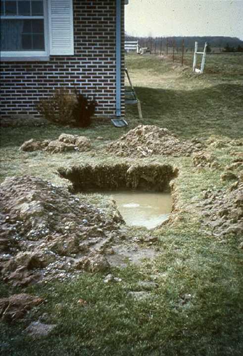
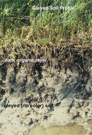
30 Water Tables

31 Water Tables Seasonally high water table due to poor draining soils and compaction
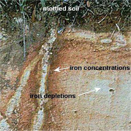
32 Prismatic soil structure is evident due to vertical redoximorphic features. A perched water table would existing above and within that horizon during wet parts of the year. Water Tables

33 Water Tables Redoximorphic features in a sandy soil can still occur. Also, the picture shows mobility of the surface sands into the sub-horizons through macropores.

34 Permeability Testing Methods Double-ring infiltrometer
35 Permeability Testing Methods Standard percolation test hole

36 Permeability Testing Methods Maryland falling-head cased borehole

37 Permeability Testing Methods Basin Flood testing, as modified from the New Jersey septic and stormwater regulations
38 Permeability Testing Methods Percolation testing allows horizontal and vertical water movement during the test. Double-ring infiltrometer testing mimics saturated vertical gravity flow with measurements taken from the inner ring.
39 Permeability Testing Methods Darcy s Law for calculating saturated hydraulic conductivity (ksat). Elrick & Reynolds equation for calculating the reduction factor, which accounts for the exfiltration occurring through the sides of percolation hole. It assumes that the percolation rate is affected by the depth of water in the hole and that the percolating surface of the hole is in uniform soil.
40 ASCE - Philadelphia Soil & Stormwater Engineering Matthew C. Hostrander, CPSS, SEO Soil Scientist Gilmore & Associates, Inc.

41 Why Stormwater Management? Groundwater Recharge Mechanism Erosion & Sediment Control (volume control) Safeguard Water Quality Waterway Protection

42 PA Best Management Practices Provides guidance for system selection, testing, analysis, construction, and maintenance. BUT The BMP Manual provides broad guidelines and should be expanded upon through testing and design. In practice, we have found that some sections need to provide more detailed guidance and information. Manual
43 START TO FINISH STORMWATER PROCESS 1. Desktop Review 2. In-situ Field Testing 3. Reporting / Recommendations 4. Stormwater Management Design 5. System Installation 6. System As-Builts 7. System Maintenance

44 DESKTOP REVIEW Review Site Soils County Soil Survey Web Soil Survey Soil Map Website Review Site Geology PA Geology Map Web Sources Review Municipal Regulations

45 DESKTOP REVIEW Possible Limitations 1. Seasonal High Water Table / Perched Water Table 2. Fine Grained Soils 3. Shallow Groundwater 4. Shallow Bedrock 5. Karst Geology 6. Wetlands
 2. Bedrock 3.")
46 FIELD TESTING Soil Profile Descriptions Textural Class Limiting Zones 1. Seasonal High Water Table (indicated by ) 2. Bedrock 3. Groundwater

47 FIELD TESTING Infiltration Testing Methods Double-Ring Infiltrometer Standard Percolation Hole Basin Flood Maryland Borehole


48 FIELD TESTING Sealed cased borehole testing within existing athletic fields Confirmation double-ring infiltrometer testing during subsurface system installation
49 REPORTING & RECOMMENDATIONS Report Components Describe on-site soils and underlying geology Summarize infiltration rates and locations Discuss site limitations, if applicable Recommend appropriate stormwater management systems, if required

50 STORMWATER MANAGEMENT DESIGN Stormwater Management Systems Surface Systems Basins, Rain Gardens, Vegetated Swales, Berms, etc. Subsurface Systems Subsurface Infiltration Bed, Dry Wells, Infiltration Trenches, Constructed Filters Other Systems Permeable Paving with Infiltration Beds

51 STORMWATER MANAGEMENT DESIGN Goal To best match field conditions with a stormwater management design that responsibly promotes infiltration and mimics natural processes.

52 SYSTEM INSTALLATION Installation Challenges Compaction of the subgrade Construction practices Material selection Engineering (size, location, function)
 Vacuum cleaning (permeable pavements only) Structural")
53 SYSTEM MAINTENANCE Trim plantings Mow grasses Rehabilitation & Restoration (sediment) Observation port inspections (subsurface) Vacuum cleaning (permeable pavements only) Structural inspections
54 Q & A Stormwater Testing Stormwater BMP Design Regulatory BMP Manuals / Guidance Documents Consultant s Role Stormwater s Future


55 ASCE - Philadelphia Web Soil Survey: The Official Soil Survey Matthew C. Hostrander, CPSS, SEO Soil Scientist Gilmore & Associates, Inc.
56 Overview Web Soil Survey from the USDA Natural Resource Conservation Service Creating AOIs and Soil Reports Soil Data Explorer Soil Suitabilities, Properties, and Qualities Soil Map from PSU


57 Web Soil Survey Provides alternative to traditional hardcopy publication Provides means for quicker delivery of information Provides interactive access to most current data
58 Web Soil Survey Web Soil Survey allows the customer to get just the information they want or select The customer can obtain their geographic area of interest (AOI) information The customer can obtain relevant information to help answer their land use concerns (e.g. basements, crops, septic systems, etc.) Web Soil Suvey provides color imagery or topographic map backdrops for the AOI selected by the user Once the AOI is selected, a myriad of Soil Data Mart tables are available for viewing and use
59 Web Soil Survey Web Soil Survey can provide the user with a custom soil resource report (pdf format) via the free shopping cart The customized report can be prepared by AOI, soil map, map unit legend, map unit descriptions, etc. The user has the ability to customize the report with multiple soil data properties, capabilities, uses, and many others

60 Web Soil Survey Demonstration NRCS has 76 page WSS Tutorial available for use

61 Web Soil Survey WSS will generate a customized soil report for any project. The report, if small, can be printed directly from the website; however, for larger files, the report can be compiled externally and ed to you when complete.
IOWA FFA STATE SOILS CDE SATURDAY, OCTOBER 13, 2007 AMES, IOWA
 IOWA FFA STATE SOILS CDE SATURDAY, OCTOBER 13, 2007 AMES, IOWA 1. Moderately sloping has what percent slope: a. 9-14% b. 2-5% c. 5-9% d. over 14% 2. Which of the following horizons is the loose underlying
Soil Horizons cont. Oa- highly decomposed Oi-undecomposed
 Soils Soil Basics Soil Horizons Soil Horizons cont. O Horizon: Or organic layer Organic layer of decomposing plant and animal tissue. Wooded upland areas have thin O horizons Wetlands may have thick O
Soil Colors, Texture & Structure
 Application Soil Colors, Texture & Structure Limiting conditions Soil color type/depth of system Bedrock type/depth of system Soil texture, structure, percolation rate size and type of system Sara Heger,
Soil Interpretations Erosion and Sedimentation Control Planning and Design Workshop
 Soil Interpretations Erosion and Sedimentation Control Planning and Design Workshop Presented by Richard Brooks Presentation prepared by Kristin May Resource Soil Scientists USDA-Natural Resources Conservation
Horner-McLaughlin Woods: Soil Types
 Horner-McLaughlin Woods: Soil Types Not present at HMW Adrian Muck Conover Loam 0-4% Slopes Houghton Muck Miami Loam 2-6% Slopes Miami Loam 6-12% Slopes Miami Loam 12-18% Slopes t 0 0.125 0.25 Miles Mary
2016 Area 3 Envirothon Muskingum County Soils Test ANSWER KEY
 2016 Area 3 Envirothon Muskingum County Soils Test ANSWER KEY 1. The majority of the bedrock in Muskingum County is. a. sedimentary bedrock b. glacial bedrock c. igneous bedrock d. metamorphic bedrock
2018 Iowa FFA Soil Judging CDE Exam 1. Landscape positions characterizes the location of the soil on the landscape and identifies potential risks.
 2018 Iowa FFA Soil Judging CDE Exam 1. Landscape positions characterizes the location of the soil on the landscape and identifies potential risks. Which landscape position is considered the floodplain
2012 FINAL SOILS AREA 2 Envirothon Questions Answer KEY
 2012 FINAL SOILS AREA 2 Envirothon Questions Answer KEY Questions 1-6 to be answered at the soil pit: 1. Soil scientists categorize soils by drainage classes. What is the drainage class of the soil at
2011 Wisconsin Envirothon Soils and Land Use Exam
 2011 Wisconsin Envirothon Soils and Land Use Exam USE THE OCONTO COUNTY SOIL SURVEY TO ANSWER QUESTIONS 1-4 The Pensaukee River Wetland Complex is a mixture of state (Pensaukee Wildlife Area) and privately
Section 1. Judging the soil pit (questions 1-4)
") CONNECTICUT ENVIROTHON 2009 SOILS QUESTIONS Please select the best response to the following questions. There are 25 questions; each question is worth 4 points. Section 1. Judging the soil pit (questions
CONNECTICUT ENVIROTHON 2009 SOILS QUESTIONS Please select the best response to the following questions. There are 25 questions; each question is worth 4 points. Section 1. Judging the soil pit (questions
2014 Iowa FFA Soil Judging CDE Exam
 2014 Iowa FFA Soil Judging CDE Exam 1. Landscape position is one aspect of evaluating the surface features of a certain tract of land. Identifying the correct landscape position will indicate: a. If the
Overview of Soil Properties
 Willie Harris apatite@ufl.edu Acknowledgments: Wade Hurt Mike Vepraskas FAESS Soil Scientists Overview of Soil Properties Website to download files of talks: wgharris.ifas.ufl.edu.hsw.htm Meaning of Soil
Overview of Soil Properties
 Willie Harris apatite@ufl.edu Acknowledgments: Wade Hurt Mike Vepraskas FAESS Soil Scientists Overview of Soil Properties Website to download files of talks: wgharris.ifas.ufl.edu.hsw.htm Meaning of Soil
Iowa FFA Soil Career Development Event 2008
 Iowa FFA Soil Career Development Event 2008 1. In Iowa, corn suitability ratings for soil mapping units specifies a. natural weather conditions b. surface and subsurface drainage installed where needed
2017 Iowa FFA Soil Judging CDE Exam
 2017 Iowa FFA Soil Judging CDE Exam 1. Landscape positions vary in soil composition and makeup. What landscape position would be characterized by having strata and lenses of different textures in the profile:
1 Describe the concept of soil texture and its importance. 2 Determine the texture of a soil sample.
 Interest Approach Provide students with various samples of soil. One sample should be nearly all sand, one nearly all clay, and one nearly all silt. Ask students to determine how the samples differ. Would
DO YOU KNOW YOUR SOILS? (Rev. 10/11)
") DO YOU KNOW YOUR SOILS? (Rev. 10/11) Circle all the correct answers. 1. What is the layer normally present on the surface of the soil in cropped fields? a. O c. Ap e. B g. R b. A d. E f. C 2. Available
DO YOU KNOW YOUR SOILS? (Rev. 10/11) Circle all the correct answers. 1. What is the layer normally present on the surface of the soil in cropped fields? a. O c. Ap e. B g. R b. A d. E f. C 2. Available
Soil characteristics that influence nitrogen and water management
 Section C Soil characteristics that influence nitrogen and water management Soil characteristics vary across the landscape Soils vary from one field to another, and often within the same field. Soil differences
Team number Page 1 of Canon Envirothon Soils Station Test. Soils and Climate Change
 Team number Page 1 of 9 2006 Canon Envirothon Soils Station Test Soils and Climate Change There are many kinds of soil on the surface of the earth. The kind of soil that is present at a given location
CONNECTICUT ENVIROTHON 2012 SOILS QUESTIONS
 CONNECTICUT ENVIROTHON 2012 SOILS QUESTIONS Please select the best response to the following questions. There are 25 4 point questions. Many have more than one part. Good luck! Section 1: Judging the soil
ON LANDSCAPING, SOILS, SOIL AMENDMENTS AND PROPER SEED ESTABLISHMENT (BOTH GRASS LAWNS AND MEADOWS).
.") ON LANDSCAPING, SOILS, SOIL AMENDMENTS AND PROPER SEED ESTABLISHMENT (BOTH GRASS LAWNS AND MEADOWS). John D. Chibirka USDA-NRCS Resource Soil Scientist 1238 County Welfare Road, Suite 220 Leesport, PA
ON LANDSCAPING, SOILS, SOIL AMENDMENTS AND PROPER SEED ESTABLISHMENT (BOTH GRASS LAWNS AND MEADOWS). John D. Chibirka USDA-NRCS Resource Soil Scientist 1238 County Welfare Road, Suite 220 Leesport, PA
EXAMPLE Point A: Sandy Loam: 65% Sand _ 20% Silt _ 15% Clay. Point B: %Sand % Silt % Clay. Point C: %Sand % Silt % Clay. Point D: %Sand % Silt % Clay
 SOIL TEXTURE Refers to proportions of sand, silt and clay size particles. These proportions determine water infiltration rates, permeability rates, and water holding rates. Using a soil texture triangle.
Soils and the Environment. A Summary of RI Envirothon Study Materials Compiled by Sally Paul
 Soils and the Environment A Summary of RI Envirothon Study Materials Compiled by Sally Paul Why Soils Food and water resources Disposing of waste Support for human structures Growing timber and fibers
1. Position (2 pts.) 2. Parent Material (2 pts.) 3. Slope Characteristics (2 pts.) 4. Surface Stoniness or Rockiness (2 pts.)
 2. Parent Material (2 pts.) 3. Slope Characteristics (2 pts.) 4. Surface Stoniness or Rockiness (2 pts.)") Maryland Envirothon SOILS Exam Guidance Information (revised 2017) Objective: To test students' knowledge and awareness of basic soil science and its application in wise land-use planning and therefore
Maryland Envirothon SOILS Exam Guidance Information (revised 2017) Objective: To test students' knowledge and awareness of basic soil science and its application in wise land-use planning and therefore
Reference Card S-2, Side A: Delineating Horizon Boundaries
 Reference Card S-2, Side A: Delineating Horizon Boundaries Distinguishing Soil Horizons Soil horizons are delineated based on differences in: Texture Color Structure and Consistence Redoximorphic Features
2016 Iowa FFA Soils Evaluation CDE Exam
 2016 Iowa FFA Soils Evaluation CDE Exam 1. Which of the following is true regarding soil horizons? a. A horizon is darker in color and has more organic matter b. B horizon is darker in color and has more
Soil Physical Properties
 Soil Physical Properties ESRM 311 SEFS 507 Some examples of mineral soil development eg, Rock Weathering Types of Weathering Physical/Mechanical Chemical Biological Photo by D Vogt CO 2 + H 2 O H 2 CO
2014 Envirothon Georgia Soil Study Guide
 2014 Envirothon Georgia Soil Study Guide In addition to materials in this document, 2014 Georgia Envirothon contestants are responsible for materials found in the following documents: From The Surface
3. What are the five master horizons? Give distinguishing features of each. 5. List three means by which plant roots come into contact with nutrients.
 Study Questions Exam 1 1. What are the four general components of soil? 2. Define regolith and solum. 3. What are the five master horizons? Give distinguishing features of each. 4. What is meant by an
Special Assignment for Wednesday: Watch video on soil texture analysis https://youtu.be/ioyabxj767s
 Special Assignment for Wednesday: Watch video on soil texture analysis https://youtu.be/ioyabxj767s Lecture 3: Soil Physical Properties Important Physical Properties Soil Color: Most obvious physical property;
Recommended Resources: The following resources may be useful in teaching this lesson:
 Unit E: Basic Principles of Soil Science Lesson 4: Understanding Soil Texture and Structure Student Learning Objectives: Instruction in this lesson should result in students achieving the following objectives:
URBAN SOILS & SEATTLE EXAMPLES
 Class Results - Mystery Soil #1 14 12 10 8 6 4 2 0 Sandy Clay Loam Sandy Loam Silty Loam Class Results - Mystery Soil #2 6 5 4 3 2 1 0 Silty Clay Clay Loam Sandy Sandy Silty Sandy Silty Loamy Loam Clay
Soil Maps for Production Agriculture. Jarrod O. Miller, Extension Agronomist
 Soil Maps for Production Agriculture Jarrod O. Miller, Extension Agronomist Origination of Soil Mapping Originally mapped by Division of Soils Federal Bureau of Soils Soil Conservation Service (SCS) started
2.1.4 Roof Downspout Rain Gardens
 2008 SWMM, 2010 Revision City of Tacoma 2.1.4 Roof Downspout Rain Gardens Purpose and Definition Bioretention areas are shallow stormwater retention facilities designed to mimic forested systems by controlling
Why do soils differ across the landscape?
 Today s Objectives: Elements of soil formation Describe important soil physical & chemical properties Describe the ability to use and interpret soil survey information (printed and digital) List some site
Lesson 1: Identifying Texture in Soil
 Lesson 1: Identifying Texture in Soil 1 Clods Loam Peds Permeability Soil structure Soil texture Soil workability Textural triangle Water-holding capacity 2 I. A. Soil texture is the fineness or coarseness
AGRONOMY 255, 251, 270 SOIL DIFFERENCES
 Name AGRONOMY 255, 251, 270 SOIL DIFFERENCES Soils differ strikingly from each other. This week we illustrate the great differences and ask you to learn how they differ and to become skilled in describing
HORT 102: Soil Properties. Cultivated Plants: Lecture 15. [Teresa Koenig] Slide #: 1 Slide Title: Intro Information Slide
![HORT 102: Soil Properties. Cultivated Plants: Lecture 15. [Teresa Koenig] Slide #: 1 Slide Title: Intro Information Slide](/thumbs/76/74082590.jpg "HORT 102: Soil Properties. Cultivated Plants: Lecture 15. [Teresa Koenig] Slide #: 1 Slide Title: Intro Information Slide") HORT 102: Soil Properties Cultivated Plants: Lecture 15 [Teresa Koenig] Slide #: 1 Slide Title: Intro Information Slide Title: Lecture 15 Soil Properties Speaker: Teresa Koenig Created by: Teresa Koenig,
HORT 102: Soil Properties Cultivated Plants: Lecture 15 [Teresa Koenig] Slide #: 1 Slide Title: Intro Information Slide Title: Lecture 15 Soil Properties Speaker: Teresa Koenig Created by: Teresa Koenig,
Soils and Land Use Test
 SOIL PROPERTIES Total Score /50 1) List two of the five main functions of soil. (2 points) Habitat for organisms, Engineering medium, Filters and stores water, Anchor for plants, Cycles nutrients 2) Small
Learning Objectives Part 1. Chapter 4 Soil Physical Properties. Soil Physical Properties. Color. Physical properties part 1
 Learning Objectives Part 1 Chapter 4 Soil Physical Properties Know what color tells you about a soil Describe the concept of soil texture and its importance Use the textural triangle to determine a soil
Pits 1 & 3 Questions. 7. Subsurface: Texture (5 pts) A. Coarse B. Moderately course C. Medium D. Fine E. Very Fine
 A. Coarse B. Moderately course C. Medium D. Fine E. Very Fine") Minnesota Soils Scorecard Questions for Pits 1-4 Scantron # 105481 Use your soils scorecard to fill out the answers on your scantron Bubble in the front side of the sheet for Pit 1 (# 1-45) and Pit 2 (#51-95)
Minnesota Soils Scorecard Questions for Pits 1-4 Scantron # 105481 Use your soils scorecard to fill out the answers on your scantron Bubble in the front side of the sheet for Pit 1 (# 1-45) and Pit 2 (#51-95)
Class 1: Introduction to Soil Formation, Texture and Structure. Chris Thoreau February 11, 2012
 Class 1: Introduction to Soil Formation, Texture and Structure Chris Thoreau February 11, 2012 Soil is a dynamic composition of: Minerals Water and its solutions Organic matter (detritus) Air and other
If you are not able to turn in your notebook see me or Dan ASAP
 Notebook Collection Collecting hard copies now OR Electronic versions using Catalyst drop box Due by 5:30 pm today Use website for link If you are not able to turn in your notebook see me or Dan ASAP URBAN
5.1 Introduction to Soil Systems IB ESS Mrs. Page
 5.1 Introduction to Soil Systems IB ESS Mrs. Page 2015-2016 I Am Soil Thinking Routine: See, Think, Wonder Look at the following images. For each image write down what you see Then write down what you
Soil Texture = %Sand, Silt & Clay in a soil.
 Soils Soil Texture = %Sand, Silt & Clay in a soil. Soil texture is the single most important physical property of the soil. Knowing the soil texture alone will provide information about: 1) water flow
S9. Thin Dark Surface
 Dominant Field Indicators of Hydric Soils in Florida S9. Thin Dark Surface For use in LRRs R, S, U, and T; for testing in LRRs K and L. A layer 5 cm (2 inches) or more thick within the upper 15 cm (6 inches)
Basic Soil Science. Fundamentals of Nutrient Management. Melissa L. Wilson
 Basic Soil Science Fundamentals of Nutrient Management Melissa L. Wilson Department of Environmental Science & Technology Ag Nutrient Management Program University of Maryland, College Park Photo credit:
Unit E: Basic Principles of Soil Science. Lesson 3: Understanding Soil Color
 Unit E: Basic Principles of Soil Science Lesson 3: Understanding Soil Color 1 Important Terms Bright-colored Color Deciduous hardwood forest Dull-colored Humus Mottle-colored Native vegetation Structure
Loam: About 40% sand, 40% silt, 20% clay. Mixture of pore sizes to balance water retention and aeration. Considered the best soil for growing crops.
 Soil Characteristics Soil is formed from a combination of two Primary sources: Weathering of Parent Rock ( ) = material introduced by plants, animals, and decomposers Minor sources: Nutrients incorporated
HAVE YOU NOTICED at construction sites how a
 Explaining a Soil Profile HAVE YOU NOTICED at construction sites how a cross section of soil has a layered look? Soil near the top of the cross section is often dark, and soil below appears lighter. What
In 1983, the town evacuated and purchased by government for $36 million
 1 2 3 4 5 6 7 8 9 Introduction to Environmental Geology, 5e Chapter 17 Soil and Environment Weathering: summary in haiku form Rocks brought to surface decompose to sediment and that's weathering. Case
What is Soil? Depends on who you ask.
 SOIL What is Soil? Depends on who you ask. To a geologist: residual material formed in situ from weathering of a parent material either bedrock or sediment. not a sediment Profile from alteration of parent
SUBSURFACE DRIP DISPERSAL OF EFFLUENT for LARGE SYSTEMS. Presented by: David Morgan and Rodney Ruskin
 SUBSURFACE DRIP DISPERSAL OF EFFLUENT for LARGE SYSTEMS Presented by: David Morgan and Rodney Ruskin Program Map Making Program Soil Parent material, Relief, Time. Organisms, Color, Texture, Depth, Profile
Soil & Site Evaluator - Need to Know
 Soil & Site Evaluator - Need to Know I. The professional will understand the factors of soil development and demonstrate their importance to site evaluations. A. Topography 1. Landscape & landform description
SOIL CHARACTERIZATION USING DIAGNOSTIC PROPERTIES
 SOIL CHARACTERIZATION USING DIAGNOSTIC PROPERTIES The following are the characters of the pedologically important properties used in categorizing soils: SOIL CHARACTERIZATION Soil Profile Description:
Ingram Engineering Services, Inc. 16 Hagerty Blvd. Suite 400 West Chester PA Office Fax
 CLIENT: Inland Design PROJECT: 10 Malin Road REQUIREMENT: PROFESSIONAL ENGINEERING SERVICES: Geotech/SW LOCATION: 10 Malin Road, West Whiteland Township DATE: September 8, 2014 ATTENTION: Chuck Dobson,
Specifying Soils for Plant Growth
 Specifying Soils for Plant Growth Which by coincidence reduces runoff Timothy A. Craul, CPSSc President, Craul Land Scientists The soil must be plant friendly. The soil is a natural system. All soils are
Soil Notes. General Soil Information
 Soil Notes General Soil Information Definition Soil relatively thin surface layer of the Earth s crust consisting of mineral and organic matter that is affected by agents such as weather, wind, water,
SOIL DATA: Avondale. in Allen, TX. This information was taken from NRCS web soil survey of Collin County, Texas.
 SOIL DATA: Avondale in Allen, TX This information was taken from NRCS web soil survey of Collin County, Texas. United States Department of Agriculture Soil Conservation Service in cooperation with Texas
Do Now: From which materials do you think soil is made? Are all soils the same? Think of some ways that they are different?
 Do Now: From which materials do you think soil is made? Are all soils the same? Think of some ways that they are different? Basics Soil is a major component of the biosphere It contains solids, liquids
Lesson 3: Understanding Soil Color
 Lesson 3: Understanding Soil Color 1 Bright colored Color Dull colored Humus Mottle colored Native vegetation Structure Tall prairie grass Texture Deciduous hardwood forest 2 I. Soils have many features
Understanding Soil Texture and Structure
 Lesson C6 4: Understanding Soil Texture and Structure Unit C. Plant and Soil Science Problem Area 6. Basic Principles of Soil Science Lesson 4. Understanding Soil Texture and Structure Learning Goal: Understand
Soils in the Field. Agronomy 105 1
 Agronomy 105 1 Soils in the Field Objectives Soil pores and water quality Soil texture and plant available water Tile drainage The Revised Universal Soil Loss Equation Definitions Field Trip Study Guide
a. OVERALL PROFILE DEPTH: Assess the depth to the first restrictive layer, which can be a tree root, a rock or an
 OBSERVING SOIL PROCEDURE Using a shovel, soil probe, or soil auger, collect a soil profile. (Go as deep as you can with the equipment). Arrange the soil you remove from the ground on newspaper or in a
SOIL SCIENCE 101 FUNCTIONS OF SOIL SOIL FORMATION
 SOIL SCIENCE 101 By Dawn Pettinelli UConn Soil Nutrient Analysis Lab CT Envirothon Training, 2014 dawn.pettinelli@uconn.edu FIVE CRUCIAL ECOLOGICAL ROLES OF SOILS FUNCTIONS OF SOIL Regulate water flow
List of Equipment, Tools, Supplies, and Facilities:
 Unit C: Traits of Soil Lesson 3: Understanding Soil Color Student Learning Objectives: Instruction in this lesson should result in the students achieving the following objectives: 1. Identify physical
Soil Structure, Density, and Porosity. Laboratory #4
 Soil Structure, Density, and Porosity Laboratory #4 Objectives Understand the concept of soil structure and how it differs from soil texture. Understand how soil structure influences other soil properties.
 108 40' 29'' W Soil Map Mesa County Area, Colorado 108 36' 55'' W 39 10' 11'' N 39 6' 31'' N 4331700 4332500 4333300 4334100 4334900 4335700 4336500 4337300 4338100 701100 701900 702700 703500 704300 705100
Examining soils in the field. Examining soils in the field. Environment Agency thinksoils examining soils in the field
 Examining soils in the field thinksoils Examining soils in the field Environment Agency thinksoils examining soils in the field 31 Examining soils in the field 32 Environment Agency thinksoils examining
EDULABZ. Ans. (b) 7. The soft, porous layer with a good water-retaining capacity forms the
 7. The soft, porous layer with a good water-retaining capacity forms the") 3 SOIL I. Multiple choice questions: Tick ( ) the correct choice. 1. The process of soil formation is called (a) conservation (b) weathering (c) erosion (d) none Ans. (b) 2. Soil profile consists of (a)
3 SOIL I. Multiple choice questions: Tick ( ) the correct choice. 1. The process of soil formation is called (a) conservation (b) weathering (c) erosion (d) none Ans. (b) 2. Soil profile consists of (a)
Explaining a Soil Profile
 Lesson C1 3 Explaining a Soil Profile Unit C. Basic Principles of Agricultural/Horticultural Science Problem Area 1. Using Basic Soil Science Principles Lesson 3. Explaining a Soil Profile New Mexico Content
Agricultural Science II Soil Science Soil Structure 50 minutes
 Student Outcome Course Unit Lesson Estimated Time Agricultural Science II Soil Science Soil Structure 50 minutes Explain the importance of soil structure. Learning Objectives 1. Explain the term soil structure
Land Capability Classifications
 Land Capability Classifications Unit: Soil Science Problem Area: Basic Principles of Soil Science Student Learning Objectives. Instruction in this lesson should result in students achieving the following
Understanding Soils. 1. What is Soil? 2. What does soil do for us?
 Understanding Soils 1. What is Soil? Soil: (i) The unconsolidated mineral or organic material on the immediate surface of the earth that serves as a natural medium for the growth of land plants. (ii) The
Soil Resources. Soil Horizons
 Soil Resources Soil Uppermost layer of earth s crust that supports plants, animals and microbes Soil Forming Factors Parent Material Time Climate Organisms Topography Soil Composition Mineral Particles
Custom Soil Resource Report for Fond du Lac County, Wisconsin
 United States Department of Agriculture Natural Resources Conservation Service A product of the National Cooperative Soil Survey, a joint effort of the United States Department of Agriculture and other
APPENDIX A SIMPLIFIED APPROACH TO STORMWATER MANAGEMENT FOR SMALL PROJECTS. In West Sadsbury Township, Chester County, Pennsylvania
 APPENDIX A SIMPLIFIED APPROACH TO STORMWATER MANAGEMENT FOR SMALL PROJECTS In West Sadsbury Township, Chester County, Pennsylvania TABLE OF CONTENTS I. Introduction 3 II. Importance of Stormwater Management
LAB 12: Soils. Name School. Patrich Physical Geography Lab 1
 Name School LAB 12: Soils Soil is a mixture of weathered rock & organic matter that usually covers bedrock (solid rock that underlies all soil). Both chemical & mechanical processes are involved in the
AY-362-W. INDIANA SOIL Evaluation Field Book. Don Franzmeier, Gary Steinhardt, Cathy Egler Purdue University Department of Agronomy
 AY-362-W INDIANA SOIL Evaluation Field Book Don Franzmeier, Gary Steinhardt, Cathy Egler Purdue University Department of Agronomy Table of Contents PREFACE 3 CHAPTER 1 Soil Formation, Soil Properties,
4/23/2018. Soil John Wiley & Sons, Inc. All rights reserved. Lecture 14
 Lecture 14 Soil Lecture 14 1. The Soil System 2. Soil Properties and Major Soil Types 3. Environmental Problems Related to Soil 4. Soil Conservation and Regeneration 1 The Soil System Soil Uppermost layer
Soil is. Pieces of rock Minerals Decaying organic matter Water Air Living organisms All mixed together!
 Soil is. Pieces of rock Minerals Decaying organic matter Water Air Living organisms All mixed together! Soil Horizons the layers of soil O-horizon: the surface litter. Mainly black or brown A-horizon:
Appendices: Glossary. General Terms. Specific Terms. Low Impact Development Approaches Handbook
 67 67 General Terms Specific Terms 66 Low Impact Development Approaches Handbook The vocabulary of low impact development is evolving, and many terms are used interchangeably and to describe the same or
List of Equipment, Tools, Supplies, and Facilities:
 Unit A: Principles of Soil Lesson 3: Horizons of Soil Student Learning Objectives: Instruction in this lesson should result in the students achieving the following objectives: 1. Explain a soil profile
Explaining a Soil Profile
 Lesson C6 5 Explaining a Soil Profile Unit C. Plant and Soil Science Problem Area 6. Basic Principles of Soil Science Lesson 5. Explaining a Soil Profile Content/Process Statement: PLS3 Core Content Standard:
Explaining a Soil Profile
 Lesson A4-8: Explaining a Soil Profile Horticulture Cluster Illinois Agricultural Education Curriculum Unit A. Horticultural Science Problem Area 4. Growing Media Nutrients, and Fertilizers Lesson 8. Explaining
This definition is from the Soil Science Glossary (Soil Science Society of America).
.") What is Soil? This definition is from the Soil Science Glossary (Soil Science Society of America). soil - (i) The unconsolidated mineral or organic material on the immediate surface of the earth that serves
What is Soil? This definition is from the Soil Science Glossary (Soil Science Society of America). soil - (i) The unconsolidated mineral or organic material on the immediate surface of the earth that serves
Overview of Chapter 14
 14 Soil Resources Overview of Chapter 14 The Soil System Soil Properties and Major Soil Types Environmental Problems Related to Soil Soil Conservation and Regeneration Soil Uppermost layer of earth s crust
Soil Properties That Distinguish Ecological Sites
 Soil Properties That Distinguish Ecological Sites Mike Duniway USGS-Southwest Biological Science Center Canyonlands Research Station Moab, UT mduniway@usgs.gov Spokane, WA January 31, 2012 Ecological Sites
Soil compaction Soil Colour
 Soil compaction Soil compaction is defined as the method of mechanically increasing the density of soil. In construction, this is a significant part of the building process. If performed improperly, settlement
FFA Urban Soil CDE. Items necessary for soil judging. FFA Land Judging Contest 2015
 FFA Urban Soil CDE FFA Land Judging Contest 2015 Changes are coming to the Soil Judging Career Development Event (CDE), starting in the upcoming school year, to better reflect today s challenges with soil.
Post Construction BMPs
 Post Construction BMPs Why are Post Construction BMPs important? With increased development brings the increase of impervious cover Parking lots, rooftops, driveways Storm water runoff volume increases
Infiltration. Keep Water Where it Falls. Frank Franciosi Novozymes
 Keep Water Where it Falls Frank Franciosi Novozymes Defined refers to the movement of water into the soil layer. The rate of this movement is called the infiltration rate. If rainfall intensity is greater
Soil & Site Evaluator - Need to Know
 Soil & Site Evaluator - Need to Know I. The professional will understand the factors of soil development and demonstrate their importance to site evaluations. A. Topography 1. Landscape description 2.
Components of Soil. Humus: (a carbon sink) Dark brown or black color indicates high nitrogen content.
 Dark brown or black color indicates high nitrogen content.") Components of Soil Humus: (a carbon sink) Dark brown or black color indicates high nitrogen content. Inorganic Soil Components: Particle Size: Clay- Very fine Silt- Fine Sand- Medium Gravel- Large Discuss
Components of Soil Humus: (a carbon sink) Dark brown or black color indicates high nitrogen content. Inorganic Soil Components: Particle Size: Clay- Very fine Silt- Fine Sand- Medium Gravel- Large Discuss
Rainwater Harvesting: Soil Storage and Infiltration Systems
 Rainwater Harvesting: Soil Storage and Infiltration Systems Justin K. Mechell Texas Cooperative Extension Department of Biological and Agricultural Engineering Texas A&M University How Rainwater Harvesting
The following general requirements will be met for all planter box installations:
 Greenville County Technical Specification for: WQ-25 PLANTER BOX 1.0 Planter Box 1.1 Description Planter boxes are designed to capture and temporarily store stormwater runoff. Planter Boxes are intended
Custom Soil Resource Report for Franklin County, Washington
 United States Department of Agriculture Natural Resources Conservation Service A product of the National Cooperative Soil Survey, a joint effort of the United States Department of Agriculture and other
Custom Soil Resource Report for Kane County, Illinois
 United States Department of Agriculture Natural Resources Conservation Service A product of the National Cooperative Soil Survey, a joint effort of the United States Department of Agriculture and other
OHIO STATE UNIVERSITY EXTENSION. Soil and Nutrients. OSUE Master Gardeners Mahoning County Class of Bill Snyder March 21, 2017
 OHIO STATE UNIVERSITY EXTENSION Soil and Nutrients OSUE Master Gardeners Mahoning County Class of 2017 Bill Snyder March 21, 2017 Soil vs DIRT Ecological Roles of Soil 1. Medium for plant growth 2. Recycling
3 From Bedrock to Soil
 CHAPTER 10 3 From Bedrock to Soil SECTION Weathering and Soil Formation BEFORE YOU READ After you read this section, you should be able to answer these questions: What is soil? How do the features of soil