2 Older farm homes on the land
|
|
|
- Oswin Maurice Hancock
- 5 years ago
- Views:
Transcription


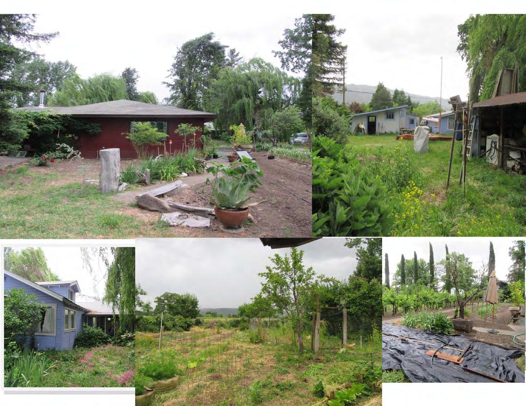
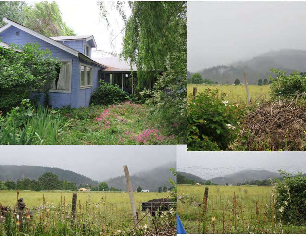
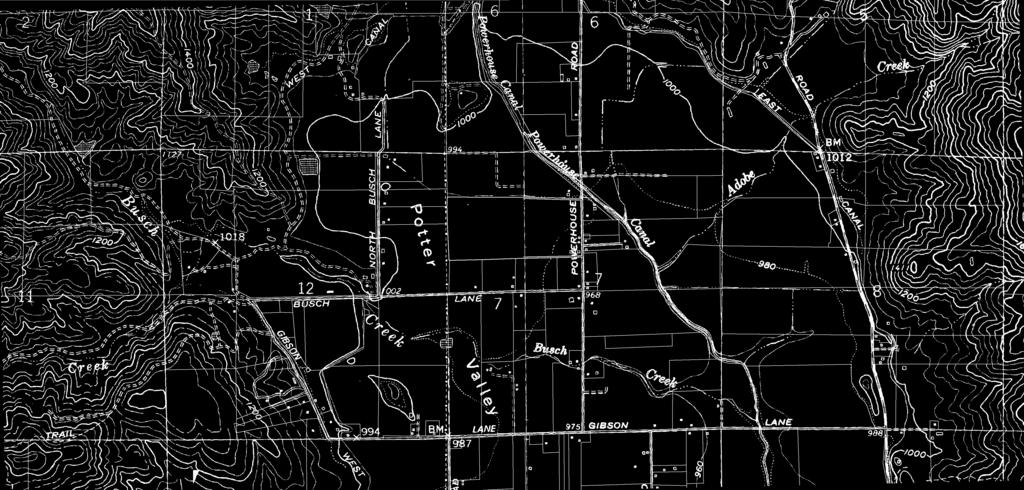
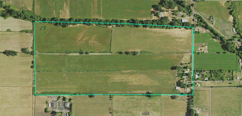
1 2 Older farm homes on the land LAND RANCHES EXCHANGES This ranch consists of 70 +/_ acres of level farmland. Prime POWERHOUSE RD POTTER VALLEY agricultural land at an attractive price. This property consists of approximately 70 acres of gorgeous, level land at the north end of Pot-ter Valley. This property features deep valley loam soils suitable for vineyards, orchards or row crops. Currently used as a cattle ranch. Located in the Potter Valley Irrigation District with abundant and cost efficient water supply. There are 2 older homes, a shop building, a barn, organic gardens and miscellaneous support buildings. Private well and PGE on site. ASKING PRICE $925,000 This is a hard to find property with deep, rich soils and abundant water available. Level farmland in Potter Valley P O N D E R O S A A N D S U N R E A L T Y R E A L T Y R E A L T Y

2

3


4 9.4 I , LAN GIBSON o a '\\ ~
5


")


6 9/8/2016 SoilWeb: An Online Soil Survey Browser California Soil Resource Lab < Close SoilWeb Zoom To Location Map Settings Help Zoom To Location Use My Current Location? About this... OR Enter a location: Go Locations may be entered as: Complete address City, state Zip code Landmark (Example: Mt. Diablo, CA) Latitude / longitude coordinate pair Examples: 38.55, N, W 38 33', ' 24" Map Settings Lat: Lon: Imagery m, DigitalGlobe, USDA Farm Report Service a map Agency error 1/4
7 9/15/2016 Official Series Description - FELIZ Series LOCATION FELIZ CA Established Series Rev. RFH DJE JJJ ET 02/2003 FELIZ SERIES The Feliz series consists of very deep, well drained soils on flood plains. These soils formed in alluvium derived from mixed sedimentary rocks and have slopes of 0 to 8 percent. Mean annual precipitation is about 37 inches and mean annual temperature is about 57 degrees F. TAXONOMIC CLASS: Fine loamy, mixed, superactive, thermic Cumulic Haploxerolls TYPICAL PEDON: Feliz loam in an irrigated vineyard of 1 percent slope at 500 feet elevation. (Colors are for dry soil unless otherwise noted. When described July 13, 1977, the soil was dry to 20 inches and moist below.) Ap 0 to 2 inches; dark grayish brown (10YR 4/2) loam, very dark grayish brown (10YR 3/2) moist; moderate medium subangular blocky structure; hard, friable, slightly sticky and slightly plastic; many very fine and fine roots; common very fine and fine interstitial pores; slightly acid (ph 6.1); abrupt smooth boundary. A 2 to 7 inches; dark grayish brown (10YR 4/2) loam, very dark brown (10YR 2/2) moist; moderate coarse and very coarse subangular blocky structure; very hard, friable, slightly sticky and slightly plastic; common very fine and fine roots; many very fine and fine interstitial pores; 5 percent 2 to 15 mm pebbles; neutral (ph 7.0); abrupt wavy boundary. AC 7 to 26 inches; dark grayish brown (10YR 4/2) clay loam, very dark brown (10YR 2/2) moist; moderate medium and coarse subangular blocky structure; hard, friable, sticky and slightly plastic; common very fine and fine roots; many very fine and common fine interstitial and few medium tubular pores; 5 percent 2 to 20 mm pebbles; slightly alkaline (ph 7.5); clear wavy boundary. (Combined thickness of the A horizon ranges from 20 to 46 inches) C1 26 to 39 inches; dark grayish brown (10YR 4/2) clay loam, very dark gray (10YR 3/1) moist; moderate medium and coarse subangular blocky stricture; hard, friable, sticky and plastic; few very fine and fine roots; common very fine and fine interstitial pores; 3 percent 2 to 20 mm pebbles; slightly alkaline (ph 7.5); clear wavy boundary. C2 39 to 55 inches; dark grayish brown (10YR 4/2) clay loam, very dark gray (10YR 3/1) moist; weak medium subangular blocky structure parting to moderate fine granular; slightly hard, friable, sticky and plastic; few very fine and fine roots; common very fine and fine interstitial pores; 5 percent 2 to 20 mm pebbles; slightly alkaline (ph 7.5); gradual wavy boundary. C3 55 to 62 inches; dark grayish brown (10YR 4/2) loam, dark brown (10YR 3/3) moist; weak medium subangular blocky structure; slightly hard, friable, slightly sticky and slightly plastic; few very fine and fine roots; common fine interstitial pores; 13 percent 2 to 75 mm pebbles; slightly 1/3
8 9/15/2016 Official Series Description - FELIZ Series alkaline (ph 7.5). (Combined thickness of the C horizons ranges from 15 to over 60 inches) TYPE LOCATION: Mendocino county, California; south of Hopland on Mountain House Road 1,700 feet south of Feliz Creek Bridge, then 700b feet west of road, on south side of vineyard avenue; 4,850 feet north and 700 feet east of the southwest corner of section 30, T.13 N., R.11 W., M.D.B.M. in the Sanel Land Grant, Hopland 7 1/2 minutes Quadrangle. RANGE IN CHARACTERISTICS: The thickness of the solum ranges from 20 to 46 inches. The soil is more than 60 inches deep. Where not irrigated, the soil is dry in all parts between the depths of 6 and 18 inches from June to October and is moist in all parts from December to May. It is moist in some part from October to June. Mean annual soil temperature varies from 59 to 62 degrees F and is less than 47 degrees F for 30 to 60 days in December and January. Rock fragment content ranges form 0 to 15 percent throughout the solum. The A horizon is 10YR 4/2, 5/2 or 5/3. Moist color is 10YR 2/2, 3/2 or 3/3. It has 18 to 30 percent clay. Base saturation (sum) is 75 to 95 percent. Reaction is slightly acid through slightly alkaline. The C horizon is 10YR 4/2, 4/3, 5/2, 5/3 or 6/3. Moist color is 10YR 3/1, 3/2, 3/3, 4/2 or 4/3. It is loam or clay loam with an average of 20 to 30 percent clay. Below 36 inches, some pedons have very gravelly loam, very gravelly clay loam or very gravelly sandy clay loam substrata. Reaction is neutral or slightly alkaline. COMPETING SERIES: These are the Colpien (T CA), Marimel (CA) and Still (CA) series. Marimel soils have lime and mottles in the lower part of the control section. Still soils have moderately slow permeability and are dry for 120 days. Colpien soils are effervescent in some part of the series control section. GEOGRAPHIC SETTING: Feliz soils are on flood plains and fans and have slopes of 0 to 8 percent. The soils formed in alluvium from sedimentary rocks. Elevations are 160 to 1,750 feet. The climate is subhumid with hot dry summers and cool moist winters. Mean annual precipitation ranges form 32 to 60 inches. Mean January temperature is 44 degrees F; mean July temperature is 72 degrees F; mean annual temperature varies from 54 to 59 degrees F. Frost-free period is 175 to 250 days. GEOGRAPHICALLY ASSOCIATED SOILS: These are the Cole, Russian and Talmage soils. Cole soils are fine. Russian soils are coarse- loamy. Talmage soils are loamy-skeletal. DRAINAGE AND PERMEABILITY: Well drained; slow to medium runoff; moderate permeability. USE AND VEGETATION: Used for cropland growing walnuts, pears, prunes, grapes and irrigated pasture. DISTRIBUTION AND EXTENT: Northern California in the valleys of the Coast Range. The soils are not extensive. MLRA is 14. MLRA SOIL SURVEY REGIONAL OFFICE (MO) RESPONSIBLE: Davis, California SERIES ESTABLISHED: Mendocino County, California, Eastern Part, REMARKS: The activity class was added to the classification in February of Competing series were not checked at that time. - ET 2/3
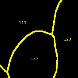
9 9/8/2016 SoilWeb: An Online Soil Survey Browser California Soil Resource Lab Map Unit Name: Feliz loam, 0 to 2 percent slopes Symbol: 123 Map Unit Composition 85% - Feliz Geomorphic Position: alluvial fans / Backslope 3% - Pinnobie 3% - Unnamed Geomorphic Position: depressions Horizon data n/a 3% - Cole 2% - Pinole 1% - Russian 1% - Talmage 1% - Xerofluvents Map Unit Data Map Unit Key: Type: Consociation? Farmland Class: Prime farmland if irrigated Available Water Storage (0-100cm): cm Max Flood Freq: None Drainage Class (Dominant Condition): Well drained? Drainage Class (Wettest Component): Well drained? Proportion of Hydric Soils: 3%? Min. Water Table Depth (Annual): n/a Min. Water Table Depth (April-June): n/a Min. Bedrock Depth: n/a Survey Metadata: ca687 [NRCS Export: Sep ] Soil Profiles 3/4


10 Potter Valley, California, United States p f ~ 0 l2=j~~== J ibsoj n \ ~( 0 mi Copyright Microsoft Corp. and/or its suppliers. All rights reserved. Copyright 2002 by Geographic Data Technology, Inc. All rights reserved Navigation Technologies. All rights reserved. This data includes information taken with permission from Canadian authorities Government of Canada (Statistics Canada and/or Geomatics Canada), all rights reserved.
Horner-McLaughlin Woods: Soil Types
 Horner-McLaughlin Woods: Soil Types Not present at HMW Adrian Muck Conover Loam 0-4% Slopes Houghton Muck Miami Loam 2-6% Slopes Miami Loam 6-12% Slopes Miami Loam 12-18% Slopes t 0 0.125 0.25 Miles Mary
TAXONOMIC CLASS: Loamy-skeletal, mixed, mesic Vitrandic Durochrepts
 ESRM311/SEFS507 Important Soil Series in Seattle Area ALDERWOOD SERIES The Alderwood series consists of moderately deep, moderately well drained soils formed in glacial till. Alderwood soils are on glacially
Soil Maps for Production Agriculture. Jarrod O. Miller, Extension Agronomist
 Soil Maps for Production Agriculture Jarrod O. Miller, Extension Agronomist Origination of Soil Mapping Originally mapped by Division of Soils Federal Bureau of Soils Soil Conservation Service (SCS) started
Erosion and Deposition & Land Use. Erosion & Deposition 2/18/2016. Soil Conservation Safeguarding soil from depletion and/or deterioration
 Soils & Land Use ESRM311- SEFS507 Erosion and Deposition & Land Use Redmond Ridge & Snoqualmie Valley Erosion & Deposition Definitions of erosion and deposition Examples of erosion and deposition Examples
Parent Material & some of Seattle s soils
 Parent Material & some of Seattle s soils ESRM 311/SEFS 507 Week 3 SOILS = f(cl, r, o, p, t) Parent Materials 1) Sedentary a) residual (bedrock weathered in place) b) organic 2) Transported by a) gravity
2011 Wisconsin Envirothon Soils and Land Use Exam
 2011 Wisconsin Envirothon Soils and Land Use Exam USE THE OCONTO COUNTY SOIL SURVEY TO ANSWER QUESTIONS 1-4 The Pensaukee River Wetland Complex is a mixture of state (Pensaukee Wildlife Area) and privately
Soil Physical Properties
 Soil Physical Properties ESRM 311 SEFS 507 Some examples of mineral soil development eg, Rock Weathering Types of Weathering Physical/Mechanical Chemical Biological Photo by D Vogt CO 2 + H 2 O H 2 CO
Preliminary Soil Survey at N Fifikh Site
 Feasibility Study on Water Resources Development in Rural Area in the Kingdom of Morocco Final Report Volume VII Data Book Data Book SO Soil Survey SO2 Preliminary Soil Survey at N Fifikh Site Preliminary
Unknown 1. Unknown 2 TEXTURE ANALYSIS
 Unknown 1 Unknown 2 TEXTURE ANALYSIS 1 5 8 11 1 22 1 12 10 Parent Material & some of Seattle s soils ESRM 311/SEFS 507 Week 3 SOILS = f(cl, r, o, p, t) Parent Materials 1) Sedentary a) residual (bedrock
Should a landowner plant red alder?
 INTRODUCTION The decision to plant red alder is both biological and financial. This paper will address the biological aspects of red alder tree growing will red alder seedlings survive well, grow fast,
STATEMENT OF PHYSICAL CHARACTERISTICS AND AGRICULTURAL LAND CLASSIFICATION WITTON PARK, COUNTY DURHAM PROPOSED QUARRY EXTENSION DECEMBER 1992

 108 40' 29'' W Soil Map Mesa County Area, Colorado 108 36' 55'' W 39 10' 11'' N 39 6' 31'' N 4331700 4332500 4333300 4334100 4334900 4335700 4336500 4337300 4338100 701100 701900 702700 703500 704300 705100
STATEMENT OF PHYSICAL CHARACTERISTICS AND AGRICULTURAL LAND CLASSIFICATION
 STATEMENT OF PHYSICAL CHARACTERISTICS AND AGRICULTURAL LAND CLASSIFICATION BIRKWOOD FARM, ALTOFTS WEST YORKSHIRE Proposed Opencast Extraction of Clay and coal ADAS January 1990 Leeds Regional Office File
National Audubon Society Appleton-Whittell Research Ranch Santa Cruz County, Arizona
 Soil and Range Resource Inventory of the National Audubon Society Appleton-Whittell Research Ranch Santa Cruz County, Arizona Special Report By Donald J. Breckenfeld and Daniel Robinett Natural Resources
Soil Interpretations Erosion and Sedimentation Control Planning and Design Workshop
 Soil Interpretations Erosion and Sedimentation Control Planning and Design Workshop Presented by Richard Brooks Presentation prepared by Kristin May Resource Soil Scientists USDA-Natural Resources Conservation
Photographs and Descriptions of Representative Pedons by Site
 Photographs and Descriptions of Representative Pedons by Site Site: A Classification: Typic Vitricryand Location: North-central edge of the park; Northwest over Scarface ridge from Lake Eleanor. Dominant
Topoclimate Southland Soil Technical Data Sheet No Waiau
 This Technical Data Sheet describes the typical average properties of the specified soil. It is essentially a summary of information obtained from one or more profiles of this soil that were examined and
SITE ASSESSMENT AND SEPTIC EVALUATION FOR JASON & JANET THATCHER 201 N. SPRAGUE AVED KINGSTON, PA 18704
 DATE: December 13, 2010 N.H. LICENSED DESIGNER OF SUBSURFACE DISPOSAL SYSTEMS 216 Hill Road Phone & Fax: 934-6206 Franklin, NH 03235 Cell: 393-3085 SITE ASSESSMENT AND SEPTIC EVALUATION FOR JASON & JANET
DO YOU KNOW YOUR SOILS? (Rev. 10/11)
") DO YOU KNOW YOUR SOILS? (Rev. 10/11) Circle all the correct answers. 1. What is the layer normally present on the surface of the soil in cropped fields? a. O c. Ap e. B g. R b. A d. E f. C 2. Available
DO YOU KNOW YOUR SOILS? (Rev. 10/11) Circle all the correct answers. 1. What is the layer normally present on the surface of the soil in cropped fields? a. O c. Ap e. B g. R b. A d. E f. C 2. Available
SOILS IN URBAN / SUBURBAN LANDSCAPES. Lisa Krall Soil Scientist CT USDA NRCS Tolland, CT
 SOILS IN URBAN / SUBURBAN LANDSCAPES Lisa Krall Soil Scientist CT USDA NRCS Tolland, CT What is Urban Soil? Is This Soil? Is This Soil? active gravel pit pavement and buildings vegetated roadside areas
2012 FINAL SOILS AREA 2 Envirothon Questions Answer KEY
 2012 FINAL SOILS AREA 2 Envirothon Questions Answer KEY Questions 1-6 to be answered at the soil pit: 1. Soil scientists categorize soils by drainage classes. What is the drainage class of the soil at
2016 Area 3 Envirothon Muskingum County Soils Test ANSWER KEY
 2016 Area 3 Envirothon Muskingum County Soils Test ANSWER KEY 1. The majority of the bedrock in Muskingum County is. a. sedimentary bedrock b. glacial bedrock c. igneous bedrock d. metamorphic bedrock
PROPOSED OPEN CAST COAL SITE SEPTEMBER 1992
 AGRICULTURAL LAND CLASSIFICATION AND STATEMENT OF PHYSICAL CHARACTERISTICS SKIERS SPRING, HOYLAND, SOUTH YORKSHIRE PROPOSED OPEN CAST COAL SITE SEPTEMBER 1992 ADAS LEEDS STATUTORY GROUP Job No. 98/92 MAFF
Kenya Agricultural Research Institute Kenya Soil Survey P.O. Box Tel: /
 Kenya Agricultural Research Institute Kenya Soil Survey P.O. Box 14733-00800 Tel: 4443376/4440903 E-mail - kss@iconnect.co.ke NAIROBI THE SOIL CONDITIONS OF SIX EXPERIMENTAL SITES IN MACHANG A, EMBU, KIREGE,
1. Position (2 pts.) 2. Parent Material (2 pts.) 3. Slope Characteristics (2 pts.) 4. Surface Stoniness or Rockiness (2 pts.)
 2. Parent Material (2 pts.) 3. Slope Characteristics (2 pts.) 4. Surface Stoniness or Rockiness (2 pts.)") Maryland Envirothon SOILS Exam Guidance Information (revised 2017) Objective: To test students' knowledge and awareness of basic soil science and its application in wise land-use planning and therefore
Maryland Envirothon SOILS Exam Guidance Information (revised 2017) Objective: To test students' knowledge and awareness of basic soil science and its application in wise land-use planning and therefore
September 20, 2016 Soils Investigation for Agricultural Designation Windemere Place, Missoula County, Montana
 September 20, 201 Soils Investigation for Agricultural Designation Windemere Place, Missoula County, Montana The purpose of this report is to compare on-site soils of the proposed subdivision with the
Custom Soil Resource Report for Craighead County, Arkansas
 United States Department of Agriculture Natural Resources Conservation Service A product of the National Cooperative Soil Survey, a joint effort of the United States Department of Agriculture and other
Custom Soil Resource Report Soil Map
 77 11' 22'' W Custom Soil Resource Report Soil Map 77 9' 43'' W 36 48' 13'' N 304700 304900 305100 305300 305500 305700 305900 306100 306300 306500 306700 306900 307100 36 48' 13'' N 36 47' 21'' N 4073800
IOWA FFA STATE SOILS CDE SATURDAY, OCTOBER 13, 2007 AMES, IOWA
 IOWA FFA STATE SOILS CDE SATURDAY, OCTOBER 13, 2007 AMES, IOWA 1. Moderately sloping has what percent slope: a. 9-14% b. 2-5% c. 5-9% d. over 14% 2. Which of the following horizons is the loose underlying
MAFF Ministry of Ifinil Agriculture Rsheries and Food
 MAFF Ministry of Ifinil Agriculture Rsheries and Food STATEMENT OF PHYSICAL CHARACTERISTICS AND AGRICULTURAL LAND CLASSIFICATION SHILBOTTLE COLLIERY RECLAMATION SCHEME NORTHUMBERLAND DECEMBER 1994 ADAS
Custom Soil Resource Report for Gallia County, Ohio
 United States Department of Agriculture Natural Resources Conservation Service A product of the National Cooperative Soil Survey, a joint effort of the United States Department of Agriculture and other
Section 1. Judging the soil pit (questions 1-4)
") CONNECTICUT ENVIROTHON 2009 SOILS QUESTIONS Please select the best response to the following questions. There are 25 questions; each question is worth 4 points. Section 1. Judging the soil pit (questions
CONNECTICUT ENVIROTHON 2009 SOILS QUESTIONS Please select the best response to the following questions. There are 25 questions; each question is worth 4 points. Section 1. Judging the soil pit (questions
SOIL CHARACTERIZATION USING DIAGNOSTIC PROPERTIES
 SOIL CHARACTERIZATION USING DIAGNOSTIC PROPERTIES The following are the characters of the pedologically important properties used in categorizing soils: SOIL CHARACTERIZATION Soil Profile Description:
Custom Soil Resource Report for Yamhill Area, Oregon
 United States Department of Agriculture Natural Resources Conservation Service A product of the National Cooperative Soil Survey, a joint effort of the United States Department of Agriculture and other
Custom Soil Resource Report for Polk County, Oregon
 United States Department of Agriculture Natural Resources Conservation Service A product of the National Cooperative Soil Survey, a joint effort of the United States Department of Agriculture and other
3. What are the five master horizons? Give distinguishing features of each. 5. List three means by which plant roots come into contact with nutrients.
 Study Questions Exam 1 1. What are the four general components of soil? 2. Define regolith and solum. 3. What are the five master horizons? Give distinguishing features of each. 4. What is meant by an
Iowa FFA Soil Career Development Event 2008
 Iowa FFA Soil Career Development Event 2008 1. In Iowa, corn suitability ratings for soil mapping units specifies a. natural weather conditions b. surface and subsurface drainage installed where needed
AGRICULTURAL LAND CLASSIFICATION AND STATEMENT OF PHYSICAL CHARACTERISTICS
 AGRICULTURAL LAND CLASSIFICATION AND STATEMENT OF PHYSICAL CHARACTERISTICS DALE PIT FARM. HATFIELD VOODHOUSE PROPOSED EXTRACTION OF SAND AHD GRAVEL ADAS April 1989 Leeds Regional office File Ref: 2FCS
APPENDIX A SOIL RESOURCES REPORTS
 APPENDIX A SOIL RESOURCES REPORTS United States Department of Agriculture Natural Resources Conservation Service A product of the National Cooperative Soil Survey, a joint effort of the United States Department
Custom Soil Resource Report for Southampton County, Virginia
 United States Department of Agriculture Natural Resources Conservation Service A product of the National Cooperative Soil Survey, a joint effort of the United States Department of Agriculture and other
Soils and their Relationship with Agriculture
 Soils and their Relationship with Agriculture Presentation created by Thomas Gallagher Modified by Hank Bignell Capital Area Agriculture and Horticulture Program Cornell University Cooperative Extension
Overview of Soil Properties
 Willie Harris apatite@ufl.edu Acknowledgments: Wade Hurt Mike Vepraskas FAESS Soil Scientists Overview of Soil Properties Website to download files of talks: wgharris.ifas.ufl.edu.hsw.htm Meaning of Soil
Overview of Soil Properties
 Willie Harris apatite@ufl.edu Acknowledgments: Wade Hurt Mike Vepraskas FAESS Soil Scientists Overview of Soil Properties Website to download files of talks: wgharris.ifas.ufl.edu.hsw.htm Meaning of Soil
Custom Soil Resource Report for Centre County, Pennsylvania
 United States Department of Agriculture Natural Resources Conservation Service A product of the National Cooperative Soil Survey, a joint effort of the United States Department of Agriculture and other
Custom Soil Resource Report for Hinds County, Mississippi
 United States Department of Agriculture Natural Resources Conservation Service A product of the National Cooperative Soil Survey, a joint effort of the United States Department of Agriculture and other
Soils and Land Use Test
 SOIL PROPERTIES Total Score /50 1) List two of the five main functions of soil. (2 points) Habitat for organisms, Engineering medium, Filters and stores water, Anchor for plants, Cycles nutrients 2) Small
Custom Soil Resource Report for Choctaw County, Oklahoma, and McCurtain County, Oklahoma
 United States Department of Agriculture Natural Resources Conservation Service A product of the National Cooperative Soil Survey, a joint effort of the United States Department of Agriculture and other
Soil Survey of San Luis Obispo County, California Paso Robles Area
 United States Department of Agriculture Soil Conservation Service In cooperation with University of California Agricultural Experiment Station Soil Survey of San Luis Obispo County, California Paso Robles
Custom Soil Resource Report for Fond du Lac County, Wisconsin
 United States Department of Agriculture Natural Resources Conservation Service A product of the National Cooperative Soil Survey, a joint effort of the United States Department of Agriculture and other
SUMMARY. alcholnie.doc\ih\jk
 SUMMARY A detailed Statement of Physical Characteristics and Agricultural Land Classification survey of ha of land at Stainton ("Holme Hall Quarry Extension") was carried out in September 1994. At the
Custom Soil Resource Report for Kane County, Illinois
 United States Department of Agriculture Natural Resources Conservation Service A product of the National Cooperative Soil Survey, a joint effort of the United States Department of Agriculture and other
Custom Soil Resource Report for Orange County, Virginia
 United States Department of Agriculture Natural Resources Conservation Service A product of the National Cooperative Soil Survey, a joint effort of the United States Department of Agriculture and other
Custom Soil Resource Report for Hancock County Area, Maine
 United States Department of Agriculture Natural Resources Conservation Service A product of the National Cooperative Soil Survey, a joint effort of the United States Department of Agriculture and other
AGRICULTURAL LAND CLASSIFICATION REPORT LAND AT BRANT FARM, STOURPORT-ON-SEVERN
 AGRICULTURAL LAND CLASSIFICATION REPORT LAND AT BRANT FARM, STOURPORT-ON-SEVERN INTRODUCTION 1. This report presents the findings of a detailed Agricultural Land Classification (ALC) survey on 12ha of
Soil 1/18/2012. Soils, Nutrients and Fertilizers Part I. Soil Profile
 Soils, Nutrients and Fertilizers Part I Handouts: Soil Texture Triangle ph Nutrient Availability Soil Diverse combination of weathered rock fragments and minerals, with decaying remains of plants and animals
Survey of Texas Vineyard Soils
 Survey of Texas Vineyard Soils Characteristics and Challenges Ed Hellman Professor of Viticulture Bachelor of Science in Plant and Soil Science Degree Concentrations: Viticulture and Enology Local Food
Agricultural Land Classification and Statement of Physical Characteristics Higbfield Farm Whitley Bridge North Yorkshire October 1996
 Agricultural Land Classification and Statement of Physical Characteristics Higbfield Farm Whitley Bridge North Yorkshire October 1996 Resource Planning Team ADAS Reference: 82/96 Leeds Statutory Group
AGRICULTURAL LAND CLASSIFICATION AND SOIL PHYSICAL CHARACTERISTICS LAND NEAR SHIRE HILL FARM SAFFRON WALDEN ESSEX
 AGRICULTURAL LAND CLASSIFICATION AND SOIL PHYSICAL CHARACTERISTICS LAND NEAR SHIRE HILL FARM SAFFRON WALDEN ESSEX AGRICULTURAL LAND CLASSIFICATION (ALC) AND SOIL PHYSICAL CHARACTERISTICS LAND NEAR SHIRE
a. OVERALL PROFILE DEPTH: Assess the depth to the first restrictive layer, which can be a tree root, a rock or an
 OBSERVING SOIL PROCEDURE Using a shovel, soil probe, or soil auger, collect a soil profile. (Go as deep as you can with the equipment). Arrange the soil you remove from the ground on newspaper or in a
Custom Soil Resource Report for Lane County Area, Oregon
 United States Department of Agriculture Natural Resources Conservation Service A product of the National Cooperative Soil Survey, a joint effort of the United States Department of Agriculture and other
SOIL SURVEY FOR PROPOSED WET ASH DISPOSAL FACILITY, HENDRINA POWER STATION, MPUMALANGA PROVINCE
 REPORT for Lidwala Environmental and Planning Servives by the INSTITUTE FOR SOIL CLIMATE AND WATER AGRICULTURAL RESEARCH COUNCIL SOIL SURVEY FOR PROPOSED WET ASH DISPOSAL FACILITY, HENDRINA POWER STATION,
Custom Soil Resource Report for Ulster County, New York
 United States Department of Agriculture Natural Resources Conservation Service A product of the National Cooperative Soil Survey, a joint effort of the United States Department of Agriculture and other
Custom Soil Resource Report for Polk County, Oregon
 United States Department of Agriculture Natural Resources Conservation Service A product of the National Cooperative Soil Survey, a joint effort of the United States Department of Agriculture and other
Land Capability Classifications
 Land Capability Classifications Unit: Soil Science Problem Area: Basic Principles of Soil Science Student Learning Objectives. Instruction in this lesson should result in students achieving the following
Custom Soil Resource Report for State of Connecticut
 United States Department of Agriculture Natural Resources Conservation Service A product of the National Cooperative Soil Survey, a joint effort of the United States Department of Agriculture and other
Soil Resources. Soil Horizons
 Soil Resources Soil Uppermost layer of earth s crust that supports plants, animals and microbes Soil Forming Factors Parent Material Time Climate Organisms Topography Soil Composition Mineral Particles
2014 Iowa FFA Soil Judging CDE Exam
 2014 Iowa FFA Soil Judging CDE Exam 1. Landscape position is one aspect of evaluating the surface features of a certain tract of land. Identifying the correct landscape position will indicate: a. If the
Custom Soil Resource Report for Walker County, Texas
 United States Department of Agriculture Natural Resources Conservation Service A product of the National Cooperative Soil Survey, a joint effort of the United States Department of Agriculture and other
Custom Soil Resource Report for Van Buren County, Iowa
 United States Department of Agriculture Natural Resources Conservation Service A product of the National Cooperative Soil Survey, a joint effort of the United States Department of Agriculture and other
Topoclimate Southland Soil Technical Data Sheet No. 76. Mossburn
 This Technical Data Sheet describes the typical average properties of the specified soil. It is essentially a summary of information obtained from one or more profiles of this soil that were examined and
Reference Card S-2, Side A: Delineating Horizon Boundaries
 Reference Card S-2, Side A: Delineating Horizon Boundaries Distinguishing Soil Horizons Soil horizons are delineated based on differences in: Texture Color Structure and Consistence Redoximorphic Features
Pits 1 & 3 Questions. 7. Subsurface: Texture (5 pts) A. Coarse B. Moderately course C. Medium D. Fine E. Very Fine
 A. Coarse B. Moderately course C. Medium D. Fine E. Very Fine") Minnesota Soils Scorecard Questions for Pits 1-4 Scantron # 105481 Use your soils scorecard to fill out the answers on your scantron Bubble in the front side of the sheet for Pit 1 (# 1-45) and Pit 2 (#51-95)
Minnesota Soils Scorecard Questions for Pits 1-4 Scantron # 105481 Use your soils scorecard to fill out the answers on your scantron Bubble in the front side of the sheet for Pit 1 (# 1-45) and Pit 2 (#51-95)
Soil Texture = %Sand, Silt & Clay in a soil.
 Soils Soil Texture = %Sand, Silt & Clay in a soil. Soil texture is the single most important physical property of the soil. Knowing the soil texture alone will provide information about: 1) water flow
ATTACHMENT OP-5b. Lost Creek Project Order 1 Soil Survey - Access Road Corridors & Deep Well Injection Sites February 2010
 ATTACHMENT OP-5b Order 1 Soil Survey - Access Road Corridors & Deep Well Injection Sites February 2010 TABLE OF CONTENTS 1.0 Introduction... 1 2.0 Summary of Previous Soil Surveys... 1 3.0 Methodology...
Soil Horizons cont. Oa- highly decomposed Oi-undecomposed
 Soils Soil Basics Soil Horizons Soil Horizons cont. O Horizon: Or organic layer Organic layer of decomposing plant and animal tissue. Wooded upland areas have thin O horizons Wetlands may have thick O
AGRICULTURAL LAND CLASSIFICATION AND STATEMENT OF PHYSICAL CHARACTERISTICS
 AGRICULTURAL LAND CLASSIFICATION AND STATEMENT OF PHYSICAL CHARACTERISTICS SEGHILL, NORTHUMBERLAND PROPOSED VASTE DISPOSAL SITE ADAS January 1989 Leeds Regional Office REF: 3/89 2FCS 4191 lds.rpg3.seghill
Custom Soil Resource Report for Pope County, Illinois
 United States Department of Agriculture Natural Resources Conservation Service A product of the National Cooperative Soil Survey, a joint effort of the United States Department of Agriculture and other
Vineyard Variability Due To Differences in Soil. Ann Tan UC Davis
 Vineyard Variability Due To Differences in Soil Ann Tan UC Davis Background We know that soils are important, but how much do they affect grape productivity and fruit quality? Some studies suggest a role
Custom Soil Resource Report for Franklin County, Washington
 United States Department of Agriculture Natural Resources Conservation Service A product of the National Cooperative Soil Survey, a joint effort of the United States Department of Agriculture and other
SOIL DATA: Avondale. in Allen, TX. This information was taken from NRCS web soil survey of Collin County, Texas.
 SOIL DATA: Avondale in Allen, TX This information was taken from NRCS web soil survey of Collin County, Texas. United States Department of Agriculture Soil Conservation Service in cooperation with Texas
Soil Drainage. Dr. Jim Walworth Dept. of Soil, Water & Environmental Sci. University of Arizona
 Soil Drainage Dr. Jim Walworth Dept. of Soil, Water & Environmental Sci. University of Arizona Yield (kg kernel/cm 2 ) Y = (0.04*sand) + 0.79 R 2 = 0.57 Percent Sand Pecans like well-drained soil. In Arizona
SETEC SOIL AND ENVIRONMENTAL TECHNOLOGY, INC
 Drainfield Location Information (Tracts 1-3) Note: Tract (Lot) 3 is not part of the Auction SETEC SOIL AND ENVIRONMENTAL TECHNOLOGY, INC 111 N. Franklin Street, Christiansburg, VA 4073 Phone: (540) 381-0309
Soil characteristics that influence nitrogen and water management
 Section C Soil characteristics that influence nitrogen and water management Soil characteristics vary across the landscape Soils vary from one field to another, and often within the same field. Soil differences
EARTH SCIENCE CONCEPTS -Geologic time scale
 EARTH SCIENCE CONCEPTS -Geologic time scale -Plate Tectonics -Earthquakes *result of vibrations (often due to plate movement) deep in the Earth that release energy *often occur at transform boundaries
Bell Ringer. d) Erosion e) Decomposition of organic compounds
 Erosion e) Decomposition of organic compounds") Bell Ringer 1) A rock exposed to high winds, over a long period of time, loses half of its original size. This is an example of a) Physical weathering b) Chemical weathering c) Biological weathering d)
Bell Ringer 1) A rock exposed to high winds, over a long period of time, loses half of its original size. This is an example of a) Physical weathering b) Chemical weathering c) Biological weathering d)
Custom Soil Resource Report for Clark County, Missouri
 United States Department of Agriculture Natural Resources Conservation Service A product of the National Cooperative Soil Survey, a joint effort of the United States Department of Agriculture and other
Loam: About 40% sand, 40% silt, 20% clay. Mixture of pore sizes to balance water retention and aeration. Considered the best soil for growing crops.
 Soil Characteristics Soil is formed from a combination of two Primary sources: Weathering of Parent Rock ( ) = material introduced by plants, animals, and decomposers Minor sources: Nutrients incorporated
Land for Sale. Marion County, Georgia. $2,160,000 +/- 900 Acres $2,400 per Acre
 Land for Sale Marion County, Georgia 2 Contents Property Fact Sheet... 3 Regional Map... 4 Local Map... 5 Aerial Map... 6 Major Soil Types Map... 7 Soil Classification Map... 8 Soil Classification Table...
Ecological Sites. Topics of Discussion 2/28/2014. Ecological Site Classification. Ecological Site Key. Ecological Site Descriptions
 Ecological Sites Topics of Discussion Ecological Site Classification Ecological Site Key Ecological Site Descriptions Jon Siddoway Montana NRCS Helping People Help the Land An Ecological Site is defined
Topoclimate Southland Soil Technical Data Sheet No. 11. Pukemutu
 This Technical Data Sheet describes the typical average properties of the specified soil. It is essentially a summary of information obtained from one or more profiles of this soil that were examined and
During the field surveys, several species of wading birds and ducks were observed using permanently ponded areas.
 Preliminary Engineering / Environmental Impact Statement Northwest Corridor LRT Line to Irving and DFW Airport During the field surveys, several species of wading birds and ducks were observed using permanently
2018 Iowa FFA Soil Judging CDE Exam 1. Landscape positions characterizes the location of the soil on the landscape and identifies potential risks.
 2018 Iowa FFA Soil Judging CDE Exam 1. Landscape positions characterizes the location of the soil on the landscape and identifies potential risks. Which landscape position is considered the floodplain
ASCE - Philadelphia. Soils & Stormwater Management. Matthew C. Hostrander, CPSS, SEO Soil Scientist. Gilmore & Associates, Inc.
 ASCE - Philadelphia Soils & Stormwater Management Matthew C. Hostrander, CPSS, SEO Soil Scientist Gilmore & Associates, Inc. Course Overview COURSE OUTLINE Soil Science Fundamentals Discuss United States
EDULABZ. Ans. (b) 7. The soft, porous layer with a good water-retaining capacity forms the
 7. The soft, porous layer with a good water-retaining capacity forms the") 3 SOIL I. Multiple choice questions: Tick ( ) the correct choice. 1. The process of soil formation is called (a) conservation (b) weathering (c) erosion (d) none Ans. (b) 2. Soil profile consists of (a)
3 SOIL I. Multiple choice questions: Tick ( ) the correct choice. 1. The process of soil formation is called (a) conservation (b) weathering (c) erosion (d) none Ans. (b) 2. Soil profile consists of (a)
Custom Soil Resource Report for Kent County, Maryland
 United States Department of Agriculture Natural Resources Conservation Service A product of the National Cooperative Soil Survey, a joint effort of the United States Department of Agriculture and other
Area 3 Envirothon Soils Questions Key
 Area 3 Envirothon Soils Questions Key 1. Soil aeration is the exchange of air in soil with air from the atmosphere. When a soil is well aerated, the air within the soil is very similar to the atmosphere
Custom Soil Resource Report for Centre County, Pennsylvania
 United States Department of Agriculture Natural Resources Conservation Service A product of the National Cooperative Soil Survey, a joint effort of the United States Department of Agriculture and other
Custom Soil Resource Report for McCurtain County, Oklahoma
 United States Department of Agriculture Natural Resources Conservation Service A product of the National Cooperative Soil Survey, a joint effort of the United States Department of Agriculture and other
Proposed Drainage District 88
 Proposed Drainage District 88 Report to the Dodge County Circuit Court By the: DODGE COUNTY DRAINAGE BOARD Robert Goetsch, Chairman Joseph Roche, Secretary Leonard Laufenberg, Member August 10, 2010 With
PHYSICAL CHARACTERISTICS REPORT INCORPORATING AGRICULTURAL LAND CLASSIFICATION LAND AT BOLE INGS, WESTBURTON, NOTTINGHAMSHIRE (SK805875)
") (krahs 2% I?5 PHYSICAL CHARACTERISTICS REPORT INCORPORATING AGRICULTURAL LAND CLASSIFICATION LAND AT BOLE INGS, WESTBURTON, NOTTINGHAMSHIRE (SK805875) 1.0 INTRODUCTION 1.1 The site, an area of 84.5 hectares,
(krahs 2% I?5 PHYSICAL CHARACTERISTICS REPORT INCORPORATING AGRICULTURAL LAND CLASSIFICATION LAND AT BOLE INGS, WESTBURTON, NOTTINGHAMSHIRE (SK805875) 1.0 INTRODUCTION 1.1 The site, an area of 84.5 hectares,