Tools to facilitate the use of Soil Maps in Emilia-Romagna region (Italy) Paola Tarocco
|
|
|
- Estella Gordon
- 5 years ago
- Views:
Transcription
1 Tools to facilitate the use of Soil Maps in Emilia-Romagna region (Italy) Paola Tarocco
2 Soil maps Vs Thematic maps Soil maps are not easy to manage. Legends are usually based on soil classifications (e.g. Soil Taxonomy, W.R.B., local classifications) understandable by a limited number of users (mostly soil scientists). Strategy n. 1- Translation of soil maps to more comprehensible documents (thematic maps). Strategy n. 2 Easing the use of soil maps for users. Means: use of interactive soil websites.
3 Soil websites Vs printed maps Last printed map (1:250k soil map) has been published in Why publishing on-line? Possibility of frequent updates; Ability to add much more information than in a printed map; Lower costs. Free downloading. First cartographic website on regional soils is online since 1998 (Soil Inventory of Emilia-Romagna plain).

4 Soil websites Vs printed maps Last printed map (1:250k soil map) has been published in Why publishing on-line? Possibility of frequent updates; Ability to add much more information than in a printed map; Lower costs. Free downloading. First cartographic website on regional soils is online since 1998 (Soil Inventory of Emilia-Romagna plain).


5 Soil websites in Emilia-Romagna /1 Over the years, the Web sites on soils have become three, based on different technologies and addressed to different users. Site name The soils of Emilia-Romagna on Google Earth Soil maps of Emilia-Romagna region Soil Inventory of Emilia- Romagna Short name CARTPEDO WEBGIS CATALOGO Link Homepage Owner Data Usability Geological, Seismic and Soil Survey Viewing and querying soil maps at different scales. All the derived thematic maps. Soil Inventory. Geological, Seismic and Soil Survey Viewing and querying 50k soil map and some derived thematic maps by an integrated approach. Geological maps, land use maps, Extension Service soil analyses, heavy metal analyses, shallow water table measurement sites are also available. Informative-Informatic Agricultural System Service Plot drawing, soil identification, fertilization plan calculation. Extension Service soil analyses. Water table measurement sites. Download NO YES NO
6 Soil websites in Emilia-Romagna /2 The three websites are based on the same geodatabase and share the same approach of data usage. use of polygons (delineations) of the 50k soil map as individual objects; soils within a delineation are described on the basis of their localization and percentage distribution; every soil, identified by a code and a name, is linked to a benchmark local site summarizing the main chemical and physical characters; use of an identification tool (wizard) of soil types inside a single delineation on the basis of a series of questions and answers (1 to 6 steps); use of extension service soil analyses (about 40,000) to identify soils and to input soil data necessary for the calculation of fertilization plans..
 of the agricultural sector: farmers, agricultural extension and advisory services, corporations and farm offices.")
7 Soil description in single delineations. Why? The first website was directed to users (stakeholders) of the agricultural sector: farmers, agricultural extension and advisory services, corporations and farm offices. This kind of users is usually interested to local data, such as the ones regarding their own cultivated fields. Mapping at scale 1: was chosen because of the lower costs and faster implementation time, but this type of map is not able to meet the needs of site-specific analysis. From the beginning, to overcome this problem it has been chosen to describe the soil map not by Mapping Units (as usual), but by single polygons (delineations), uniquely identified and described individually according to the locally present soils. In the oldest website at most three soils had been described in order to simplify the use for each delineation. They were and are called with local names (e.g. Cataldi), prioritizing them instead of soil classification. Over the years, users have become familiar with these names, which are commonly used by many stakeholders.
 covers the whole plain, 82% of the hills and a small part of the")
 of the soil map is identified by a numerical ID and it has a")
8 Soil polygons (delineations) of 50k Soil map Soil Map at 1: scale (2014 edition) covers the whole plain, 82% of the hills and a small part of the mountains. Each polygon (delineation) of the soil map is identified by a numerical ID and it has a specific and unique soil component (soil type, %, distribution). N soil polygons are delineated in this map.
 covers the whole plain, 82% of")
 of the soil map is identified by")
. N.")
9 Soil polygons (delineations) of 50k Soil map Soil Map at 1: scale (2014 edition) covers the whole plain, 82% of the hills and a small part of the mountains. Each polygon (delineation) of the soil map is identified by a numerical ID and it has a specific and unique soil component (soil type, %, distribution). N soil polygons are delineated in this map.
 ranges from one to twelve (on average 3-4).")
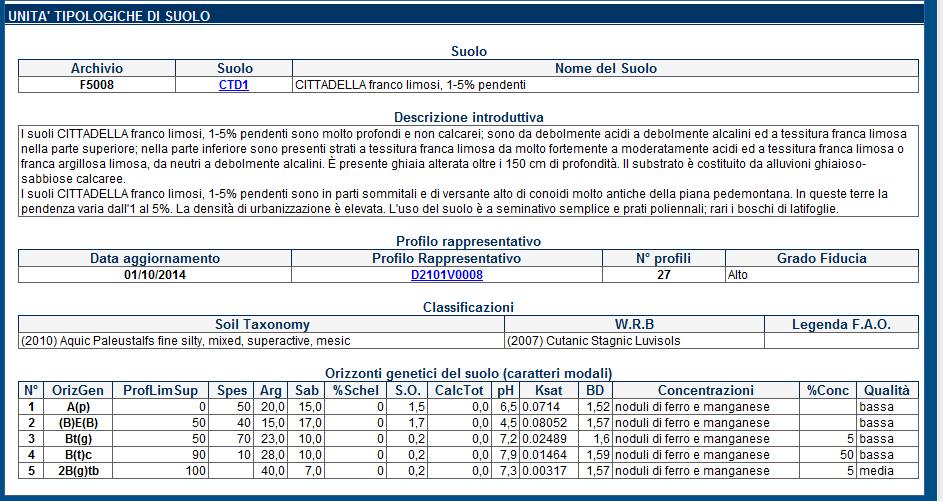
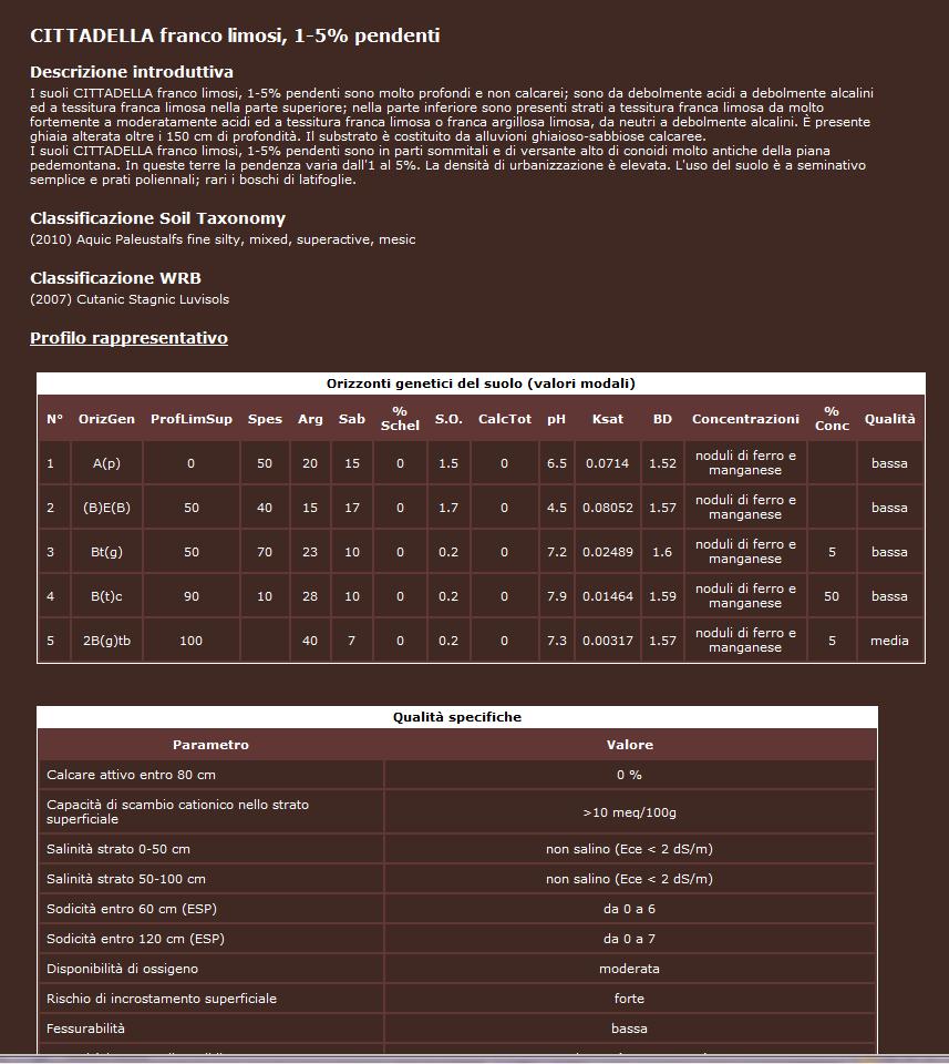
10 Soil description into single delineations The description of each polygon allows to give specific information about local soils. This is not possible using a Mapping Unit description. Within a soil polygon the number of soil types (Soil Typological Units) ranges from one to twelve (on average 3-4). At present 389 Soil Typological Units are described at this scale (210 in the plain, 144 in the hills and 35 in the mountains). Some of these soils are widespread and cover thousands of hectares; others are rare and they are present in particular landscapes only. Each soil is described, at regional scale, by a benchmark profile that is representative of soil characters.
11 Soil description into single delineations
12
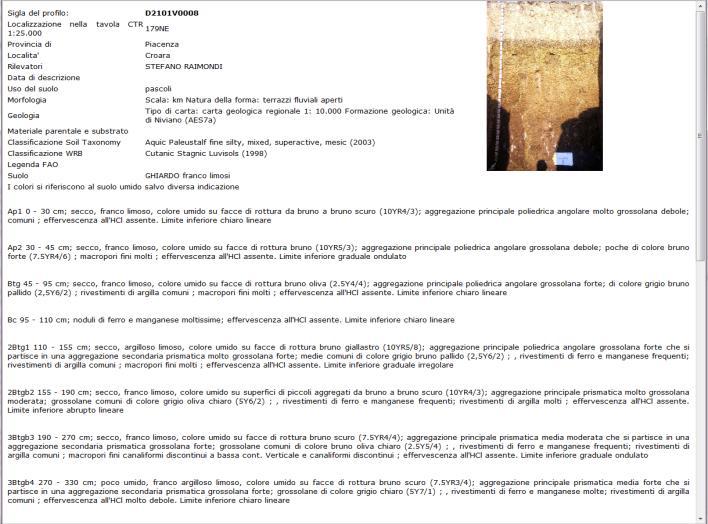
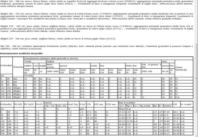
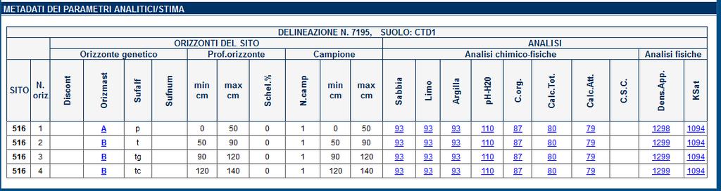
13 Benchmark local sites /1 Every soil in every polygon has been linked to an analyzed site that has been surveyed in the same polygon or in adjacent ones. The choice of these sites (benchmark sites) accounts of the local variability. For this purpose, 2869 observation sites (profiles and auger holes) with these analytical data, at least to a depth of 100 cm have been selected: sand, silt and clay; ph organic carbon total calcium carbonate For each site, on average n. 4 samples are available from the surface to a medium depth of 145 cm. The depth ranges from 30 cm (skeletal soils or soils with lithic or paralithic contact within 100 cm) to 500 cm (strongly weathered soils). Benchmark sites can be used for many applications, such as: Soil Type Identification; Input data for irrigation projects; Input data for Water Balance Models (e.g. MACRO, PELMO); Input data for fertilization models; Input data for Risk Assessment Models for contaminated sites (e.g. ASTM E2081). Building of derived maps as Land Capability Map or Permeability Map.

14 Benchmark local sites /2

15 Tool for identifying different Soil Types (WIZARD) /1 This tool works by following a dichotomous path: the users must choose between different options until a single result. 88 groups of soils have been defined and each delineation, according to its mapping unit, has been allocated to a group of soils. A number of soils (2 to 27) has been assigned to each group, on the basis of the mutual presence of soils in the landscape.

16
17 DRAINAGE PARAMETER TOPSOIL CALCIUM CARBONATE SHRINK-SWELL BEHAVIOUR PEAT LAYERS FLOODING RISK CALCIUM CARBONATE CONCRETION PRESENCE SLOPE ELEVATION TOPSOIL TEXTURE CLASS SKELETON CONTENT LAND USE SUBSOIL TEXTURE TOPSOIL COLOR Tool for identifying different Soil Types (WIZARD) /2 19 parameters, displayed as questions, can be used to make the choices. Each parameter corresponds to a set of values (2 to 32) and each value corresponds to an answer. CALCIUM CARBONATE TREND LANDSCAPE POSITION BEDROCK DEPTH SALINITY TYPICAL SOIL COLOUR ALLUVIAL PARENT MATERIAL How is the soil drainage? QUESTION What is the amount of topsoil calcium carbonate? What is the natural tendency to cracking in dry periods? Are there peat layers? How deep are them? What is the flooding risk? Are there calcium carbonate concretions? How deep are them? What is the average gradient of slopes? What is the main elevation above mean sea level? What is the texture class (USDA triangle) of topsoil? What is the rock fragment content? What is the main land use? What is the content of sand or clay (determined through the manipulation of a subsoil sample)? What is the color of topsoil? What is the trend in the percentage of calcium carbonate in depth? What is the landscape position of soils? How deep is bedrock (lithic or paralithic layer)? Are there layers with high salinity content? What is the typical colour of soil? How deep is the unaltered alluvial parent material?

18 CALCIUM CARBONATE CONCRETION PRESENCE SUBSOIL TEXTURE LANDSCAPE POSITION TOPSOIL TEXTURE CLASS TOPSOIL CALCIUM CARBONATE Tool for identifying different Soil Types (WIZARD) /3 PARAM. 1 VALUE STU PARAM. 2 VALUE STU PARAM. 3 VALUE STU CTD1 CAT1 CTD1 RIV1 CAT2 RIV1 Top surfaces ARC2 Silty clay CBE1 0% CTD2 CBE1 CDV2 MCA1 ARC1 Loam CPL1 TAV CAT1 MCA1 ARC1 Slopes Clay loam CPL1 TAV ARC2 0-2% RIR1 RIV1 CBE1 CTD2 TAV CDV2 MCA1 ARC1 CBE1 2-5% TAV Silty clay loam ARC2 CDV2 Upper slopes ARC2 CAT1 CAT1 CAT2 CAT2 >5% CAT2 CBE1 CDV2 RIR1 CDV2 CTD1 CBE1 Silt loam Lower slopes CAT2 CTD % CDV2 Medium slopes TAV Sandy loam RIR1 CPL1 PARAM. 4 VALUE STU PARAM. 5 VALUE STU CTD1 RIV1 RIV1 TAV CTD2 ARC1 Missing MCA1 Clay >35% ARC2 TAV CAT1 ARC1 CAT2 ARC2 CDV2 RIR1 CTD1 everywhere CDV2 CTD2 Clay <35% and > 50 cm CPL1 MCA1 Sand <50% CAT1 CPL1 > 80 cm CAT2 Clay>50% CBE1 CBE1 Sand >50% RIR1 For each soil group from 1 to 6 parameters have been assigned to differentiate soil types. Example on GROUP 32.
.")
19 Use of Extension Service Soil Analyses These data are routine chemical-physical analyses (sand, silt, clay, ph, total carbonate, active carbonate, organic matter, available K, available P, total N) of about 40,000 soil samples (mostly on superficial horizons). They can be used in different ways: Identification of a soil type; Input soil data necessary for the calculation of fertilization plans; Geostatistical processings.
20 Use of Extension Service Soil Analyses. Identification of Soil Type Most of these data, represented as a 1 ha polygon layer, are linked to a soil typological unit. The user can check if there are extension service soil analyses inside or nearby the area of interest.
21 Use of Extension Service Soil Analyses. Identification of Soil Type Most of these data, represented as a 1 ha polygon layer, are linked to a soil typological unit. The user can check if there are extension service soil analyses inside or nearby the area of interest.
22 Use of Extension Service Soil Analyses. Input data for fertilization plans The user has the chance to get its own soil analytical data or take advantage of the ones already available in the system. After selecting the type of soil, the user can exploit the medium values inside the delineation of these analytical data as input data for the calculation of a fertilization plan.
23
24 Use of Extension Service Soil Analyses. Input data for fertilization plans
25 Thematic maps 2 different approaches have been followed to building thematic maps: Geostatistical method. These maps are vector tiles layers, with cells 1 km x 1 km wide. 19 maps: e.g. Soil Organic Carbon % content; heavy metal background; salinity. This method has been used when a map shows a single soil parameter. Maps derived from 1:50k soil map by weighted average of the soil percentages in the delineations. 8 maps: e.g. land capability; permeability; geochemical maps. This method has been used when a map shows a complex soil property, often described by classes. To building some of these the benchmark sites have been used.

26 Thematic maps
27 Thanks for your attention!
2012 FINAL SOILS AREA 2 Envirothon Questions Answer KEY
 2012 FINAL SOILS AREA 2 Envirothon Questions Answer KEY Questions 1-6 to be answered at the soil pit: 1. Soil scientists categorize soils by drainage classes. What is the drainage class of the soil at
Land Capability Classifications
 Land Capability Classifications Unit: Soil Science Problem Area: Basic Principles of Soil Science Student Learning Objectives. Instruction in this lesson should result in students achieving the following
2014 Iowa FFA Soil Judging CDE Exam
 2014 Iowa FFA Soil Judging CDE Exam 1. Landscape position is one aspect of evaluating the surface features of a certain tract of land. Identifying the correct landscape position will indicate: a. If the
EXAMPLE Point A: Sandy Loam: 65% Sand _ 20% Silt _ 15% Clay. Point B: %Sand % Silt % Clay. Point C: %Sand % Silt % Clay. Point D: %Sand % Silt % Clay
 SOIL TEXTURE Refers to proportions of sand, silt and clay size particles. These proportions determine water infiltration rates, permeability rates, and water holding rates. Using a soil texture triangle.
2016 Area 3 Envirothon Muskingum County Soils Test ANSWER KEY
 2016 Area 3 Envirothon Muskingum County Soils Test ANSWER KEY 1. The majority of the bedrock in Muskingum County is. a. sedimentary bedrock b. glacial bedrock c. igneous bedrock d. metamorphic bedrock
 108 40' 29'' W Soil Map Mesa County Area, Colorado 108 36' 55'' W 39 10' 11'' N 39 6' 31'' N 4331700 4332500 4333300 4334100 4334900 4335700 4336500 4337300 4338100 701100 701900 702700 703500 704300 705100
2014 Envirothon Georgia Soil Study Guide
 2014 Envirothon Georgia Soil Study Guide In addition to materials in this document, 2014 Georgia Envirothon contestants are responsible for materials found in the following documents: From The Surface
HORT 102: Soil Properties. Cultivated Plants: Lecture 15. [Teresa Koenig] Slide #: 1 Slide Title: Intro Information Slide
![HORT 102: Soil Properties. Cultivated Plants: Lecture 15. [Teresa Koenig] Slide #: 1 Slide Title: Intro Information Slide](/thumbs/76/74082590.jpg "HORT 102: Soil Properties. Cultivated Plants: Lecture 15. [Teresa Koenig] Slide #: 1 Slide Title: Intro Information Slide") HORT 102: Soil Properties Cultivated Plants: Lecture 15 [Teresa Koenig] Slide #: 1 Slide Title: Intro Information Slide Title: Lecture 15 Soil Properties Speaker: Teresa Koenig Created by: Teresa Koenig,
HORT 102: Soil Properties Cultivated Plants: Lecture 15 [Teresa Koenig] Slide #: 1 Slide Title: Intro Information Slide Title: Lecture 15 Soil Properties Speaker: Teresa Koenig Created by: Teresa Koenig,
SOIL DATA: Avondale. in Allen, TX. This information was taken from NRCS web soil survey of Collin County, Texas.
 SOIL DATA: Avondale in Allen, TX This information was taken from NRCS web soil survey of Collin County, Texas. United States Department of Agriculture Soil Conservation Service in cooperation with Texas
IOWA FFA STATE SOILS CDE SATURDAY, OCTOBER 13, 2007 AMES, IOWA
 IOWA FFA STATE SOILS CDE SATURDAY, OCTOBER 13, 2007 AMES, IOWA 1. Moderately sloping has what percent slope: a. 9-14% b. 2-5% c. 5-9% d. over 14% 2. Which of the following horizons is the loose underlying
Using Land Capability Classifications
 Lesson C7 2 Using Land Capability Classifications Unit C. Plant and Soil Science Problem Area 7. Soil Erosion and Land Management Lesson 2. Using Land Capability Classifications New Mexico Content Standard:
SOIL SURVEY OF PORTIONS 81 AND 82 OFTHE FARM VAALBANK 512JQ, NEAR MAGALIESBURG, SOUTH-WEST OF PRETORIA
 REPORT For Newtown Landscape Architects SOIL SURVEY OF PORTIONS 81 AND 82 OFTHE FARM VAALBANK 512JQ, NEAR MAGALIESBURG, SOUTH-WEST OF PRETORIA By N.M. Mushia, D.G. Paterson and S.D. Mkula Report Number
Alternative Crop Suitability Methodology
 Alternative Crop Suitability Methodology The Alternative Agriculture in Missouri Hub on Community Commons includes model-based ratings of natural suitability for selected alternative crops. These ratings
Investigation into soil texture in my area
 Aim Investigation into soil texture in my area The aim of my investigation is to calculate how much sand, silt and clay is present in a sample of soil from my garden and to compare it with a sample taken
Iowa FFA Soil Career Development Event 2008
 Iowa FFA Soil Career Development Event 2008 1. In Iowa, corn suitability ratings for soil mapping units specifies a. natural weather conditions b. surface and subsurface drainage installed where needed
EDULABZ. Ans. (b) 7. The soft, porous layer with a good water-retaining capacity forms the
 7. The soft, porous layer with a good water-retaining capacity forms the") 3 SOIL I. Multiple choice questions: Tick ( ) the correct choice. 1. The process of soil formation is called (a) conservation (b) weathering (c) erosion (d) none Ans. (b) 2. Soil profile consists of (a)
3 SOIL I. Multiple choice questions: Tick ( ) the correct choice. 1. The process of soil formation is called (a) conservation (b) weathering (c) erosion (d) none Ans. (b) 2. Soil profile consists of (a)
2018 Iowa FFA Soil Judging CDE Exam 1. Landscape positions characterizes the location of the soil on the landscape and identifies potential risks.
 2018 Iowa FFA Soil Judging CDE Exam 1. Landscape positions characterizes the location of the soil on the landscape and identifies potential risks. Which landscape position is considered the floodplain
3 From Bedrock to Soil
 CHAPTER 10 3 From Bedrock to Soil SECTION Weathering and Soil Formation BEFORE YOU READ After you read this section, you should be able to answer these questions: What is soil? How do the features of soil
Soil characteristics that influence nitrogen and water management
 Section C Soil characteristics that influence nitrogen and water management Soil characteristics vary across the landscape Soils vary from one field to another, and often within the same field. Soil differences
Team number Page 1 of Canon Envirothon Soils Station Test. Soils and Climate Change
 Team number Page 1 of 9 2006 Canon Envirothon Soils Station Test Soils and Climate Change There are many kinds of soil on the surface of the earth. The kind of soil that is present at a given location
Introduction to Environmental Science. Soil Characteristics. Chapter 11 Soil
 Chapter 11 Soil Soil Characteristics It s more than dirt Most soils are 100s of years old Weathering breaks down parent rock Soil Separates (particle types) Sand (largest) Silt Clay (smallest) Plants contribute
5.1 Introduction to Soil Systems IB ESS Mrs. Page
 5.1 Introduction to Soil Systems IB ESS Mrs. Page 2015-2016 I Am Soil Thinking Routine: See, Think, Wonder Look at the following images. For each image write down what you see Then write down what you
Components of Soil. Humus: (a carbon sink) Dark brown or black color indicates high nitrogen content.
 Dark brown or black color indicates high nitrogen content.") Components of Soil Humus: (a carbon sink) Dark brown or black color indicates high nitrogen content. Inorganic Soil Components: Particle Size: Clay- Very fine Silt- Fine Sand- Medium Gravel- Large Discuss
Components of Soil Humus: (a carbon sink) Dark brown or black color indicates high nitrogen content. Inorganic Soil Components: Particle Size: Clay- Very fine Silt- Fine Sand- Medium Gravel- Large Discuss
DO YOU KNOW YOUR SOILS? (Rev. 10/11)
") DO YOU KNOW YOUR SOILS? (Rev. 10/11) Circle all the correct answers. 1. What is the layer normally present on the surface of the soil in cropped fields? a. O c. Ap e. B g. R b. A d. E f. C 2. Available
DO YOU KNOW YOUR SOILS? (Rev. 10/11) Circle all the correct answers. 1. What is the layer normally present on the surface of the soil in cropped fields? a. O c. Ap e. B g. R b. A d. E f. C 2. Available
2017 Iowa FFA Soil Judging CDE Exam
 2017 Iowa FFA Soil Judging CDE Exam 1. Landscape positions vary in soil composition and makeup. What landscape position would be characterized by having strata and lenses of different textures in the profile:
Survey of Texas Vineyard Soils
 Survey of Texas Vineyard Soils Characteristics and Challenges Ed Hellman Professor of Viticulture Bachelor of Science in Plant and Soil Science Degree Concentrations: Viticulture and Enology Local Food
PHYSICAL CHAtlACTERISTICS REPORT FOR THE PROPOSED SAND AND GRAVEL SITE AT MANOR FARM, UFFINGTON
 PHYSICAL CHAtlACTERISTICS REPORT FOR THE PROPOSED SAND AND GRAVEL SITE AT MANOR FARM, UFFINGTON Introduction Following the" request for detailed information on the physical characteristics of soil at Manor
Soil Geography Notes JC-Learn. JC-Learn. Geography Notes Soil. 1 P a g e
 JC-Learn Geography Notes Soil 1 P a g e Soil Soil is the thin covering of loose material that makes up the outermost layer of our planet. It is a living thing and a rich natural resource. Plants need soil
HAVE YOU NOTICED at construction sites how a
 Explaining a Soil Profile HAVE YOU NOTICED at construction sites how a cross section of soil has a layered look? Soil near the top of the cross section is often dark, and soil below appears lighter. What
2016 Iowa FFA Soils Evaluation CDE Exam
 2016 Iowa FFA Soils Evaluation CDE Exam 1. Which of the following is true regarding soil horizons? a. A horizon is darker in color and has more organic matter b. B horizon is darker in color and has more
List of Equipment, Tools, Supplies, and Facilities:
 Unit A: Principles of Soil Lesson 2: Overview of Soil Science Student Learning Objectives: Instruction in this lesson should result in the students achieving the following objectives: 1. Understand the
Loam: About 40% sand, 40% silt, 20% clay. Mixture of pore sizes to balance water retention and aeration. Considered the best soil for growing crops.
 Soil Characteristics Soil is formed from a combination of two Primary sources: Weathering of Parent Rock ( ) = material introduced by plants, animals, and decomposers Minor sources: Nutrients incorporated
Ecological Sites. Topics of Discussion 2/28/2014. Ecological Site Classification. Ecological Site Key. Ecological Site Descriptions
 Ecological Sites Topics of Discussion Ecological Site Classification Ecological Site Key Ecological Site Descriptions Jon Siddoway Montana NRCS Helping People Help the Land An Ecological Site is defined
Understanding Soil Variability to Utilize Variable Rate Fertilizer Technology
 Understanding Soil Variability to Utilize Variable Rate Fertilizer Technology Agronomy Update -2012 Red Deer, AB Jan 17 & 18, 2012 Ross H. McKenzie Research Scientist Agronomy Research & Innovation Div.
AGRICULTURAL LAND CLASSIFICATION
 AGRICULTURAL LAND CLASSIFICATION GOOLE/HOOK LOCAL PLAN SITES SURVEYED FOR BOOTHFERRY BOROUGH COUNCIL'S INDUSTRIAL LAND SUITABILITY STUDY ADAS February 1991 Leeds Regional Office 2FCS 5205 CONTENTS 1. Introduction
Pits 1 & 3 Questions. 7. Subsurface: Texture (5 pts) A. Coarse B. Moderately course C. Medium D. Fine E. Very Fine
 A. Coarse B. Moderately course C. Medium D. Fine E. Very Fine") Minnesota Soils Scorecard Questions for Pits 1-4 Scantron # 105481 Use your soils scorecard to fill out the answers on your scantron Bubble in the front side of the sheet for Pit 1 (# 1-45) and Pit 2 (#51-95)
Minnesota Soils Scorecard Questions for Pits 1-4 Scantron # 105481 Use your soils scorecard to fill out the answers on your scantron Bubble in the front side of the sheet for Pit 1 (# 1-45) and Pit 2 (#51-95)
Custom Soil Resource Report for Franklin County, Washington
 United States Department of Agriculture Natural Resources Conservation Service A product of the National Cooperative Soil Survey, a joint effort of the United States Department of Agriculture and other
AGRICULTURAL LAND CLASSIFICATION
 AGRICULTURAL LAND CLASSIFICATION STAINSBY HALL, MIDDLESBROUGH PROPOSED GOLF COURSE ADAS December 1990 Leeds Regional Office 2FCS 5100 CONTENTS 1. INTRODUCTION AND GENERAL SITE CHARACTERISTICS 2. AGRICULTURAL
 Soils Soil is one of the world's most important natural resources. Together with air and water it is the basis for life on planet earth. Most of our food depends on soil - it is where we find the plants
Topoclimate Southland Soil Technical Data Sheet No Waiau
 This Technical Data Sheet describes the typical average properties of the specified soil. It is essentially a summary of information obtained from one or more profiles of this soil that were examined and
SOIL SURVEY FOR PROPOSED WET ASH DISPOSAL FACILITY, HENDRINA POWER STATION, MPUMALANGA PROVINCE
 REPORT for Lidwala Environmental and Planning Servives by the INSTITUTE FOR SOIL CLIMATE AND WATER AGRICULTURAL RESEARCH COUNCIL SOIL SURVEY FOR PROPOSED WET ASH DISPOSAL FACILITY, HENDRINA POWER STATION,
Area 3 Envirothon Soils Questions Key
 Area 3 Envirothon Soils Questions Key 1. Soil aeration is the exchange of air in soil with air from the atmosphere. When a soil is well aerated, the air within the soil is very similar to the atmosphere
Soil Physical Properties I: Outline
 Soil Physical Properties I: Outline Soil color See plates between pages 114 and 115 in textbook. Soil texture Soil structure Soil color Soil color provides clues to other soil properties and to soil conditions.
The entire site supports grass on which sheep had been grazing recently.
 PHYSICAL CHARACTERISTICS REPORT FOR LAND AT HORSEHAY A^ Agricultural Land Classification of approximately 14 hectares of land to the southwest of Horsehay was undertaken in November 1989. The site lies
Custom Soil Resource Report for Polk County, Oregon
 United States Department of Agriculture Natural Resources Conservation Service A product of the National Cooperative Soil Survey, a joint effort of the United States Department of Agriculture and other
Soils and Land Use Test
 SOIL PROPERTIES Total Score /50 1) List two of the five main functions of soil. (2 points) Habitat for organisms, Engineering medium, Filters and stores water, Anchor for plants, Cycles nutrients 2) Small
Swan Coastal Plain - Reading
 Swan Coastal Plain Almost all the soils of the Swan Coastal Plain are formed by material deposited by rivers and wind. The Yilgarn Block, east and south of the scarp bordering the Swan Coastal Plain, rose
Soil Interpretations Erosion and Sedimentation Control Planning and Design Workshop
 Soil Interpretations Erosion and Sedimentation Control Planning and Design Workshop Presented by Richard Brooks Presentation prepared by Kristin May Resource Soil Scientists USDA-Natural Resources Conservation
Soil resources in upper Basho Valley.
 Soil resources in upper Basho Valley. Åge A. Nyborg, 2007 Norwegian Forest and Landscape Institute. Soil management challenges in Upper Basho Valley Low nutrient content, low organic matter content, deficient
4/23/2018. Soil John Wiley & Sons, Inc. All rights reserved. Lecture 14
 Lecture 14 Soil Lecture 14 1. The Soil System 2. Soil Properties and Major Soil Types 3. Environmental Problems Related to Soil 4. Soil Conservation and Regeneration 1 The Soil System Soil Uppermost layer
Do Now: From which materials do you think soil is made? Are all soils the same? Think of some ways that they are different?
 Do Now: From which materials do you think soil is made? Are all soils the same? Think of some ways that they are different? Basics Soil is a major component of the biosphere It contains solids, liquids
EARTH SCIENCE CONCEPTS -Geologic time scale
 EARTH SCIENCE CONCEPTS -Geologic time scale -Plate Tectonics -Earthquakes *result of vibrations (often due to plate movement) deep in the Earth that release energy *often occur at transform boundaries
THE SCORE CARD. Observed Soil Properties. Interpretive Soil Properties
 Rev. 07/18/2008 Jim Doolittle Doug Malo Tom Schumacher Plant Science Department SDSU and Kent Cooley Lance Howe Bruce Kunze Jim Millar Walt Schaefer Dan Shurtliff Steve Winter USDA Natural Resources Conservation
Soil testing Page 1. Contrary to what is widely believed, the colour of the soil reveals very little about its fertility.
 Soil testing Page 1 Soil The Basics Soil is the uppermost surface of the earth, which has been slowly transformed by decomposition due to the effects of weather, vegetation and human activities. The parent
Soil & Site Evaluator - Need to Know
 Soil & Site Evaluator - Need to Know I. The professional will understand the factors of soil development and demonstrate their importance to site evaluations. A. Topography 1. Landscape & landform description
URBAN SOILS & SEATTLE EXAMPLES
 Class Results - Mystery Soil #1 14 12 10 8 6 4 2 0 Sandy Clay Loam Sandy Loam Silty Loam Class Results - Mystery Soil #2 6 5 4 3 2 1 0 Silty Clay Clay Loam Sandy Sandy Silty Sandy Silty Loamy Loam Clay
Custom Soil Resource Report for Yamhill Area, Oregon
 United States Department of Agriculture Natural Resources Conservation Service A product of the National Cooperative Soil Survey, a joint effort of the United States Department of Agriculture and other
Presented By: Lisa Dizengoff Science Facilitator Pembroke Pines Charter School - East Campus Pembroke Pines, Florida
 Presented By: Lisa Dizengoff Science Facilitator Pembroke Pines Charter School - East Campus Pembroke Pines, Florida ldizengoff@pinescharter.com The purpose of this interactive, enlightening and engaging
Soil Notes. General Soil Information
 Soil Notes General Soil Information Definition Soil relatively thin surface layer of the Earth s crust consisting of mineral and organic matter that is affected by agents such as weather, wind, water,
Unit 1 Lesson 5 Soil Formation. Copyright Houghton Mifflin Harcourt Publishing Company
 The Dirt on Soil What causes soil to form? Soil is a loose mixture of rock fragments, organic matter, water, and air that can support the growth of vegetation. The first step in soil formation is the weathering
SOIL BASICS & CONSERVATION
 SOIL BASICS & CONSERVATION What Is Soil? Soil is a mix of eroded rock, minerals, water, air, living things, and decaying matter. Ecosystem Services of Soil Provides nutrients for plants Provides support
BC Soil Information Finder Tool. Questions
 BC Soil Information Finder Tool Questions 1 What is the Soil Information Finder Tool?... 2 2 How accurate is the information for a point on the map?... 3 3 What does Soil Erosion Potential mean?... 4 4
NRCS Soils Report. Grand River Gathering LLC K28E Compressor Station. OA Project No
 NRCS Soils Report Grand River Gathering LLC K28E Compressor Station OA Project No. 012-032 82 21 ½ Road Grand Junction, CO 81505 TEL 90.23.800 FAX 90.23.45 United States Department of Agriculture A product
DELHI PUBLIC SCHOOL TAPI
 DELHI PUBLIC SCHOOL TAPI CLASS VII SUBJECT: SCIENCE Ch 9- SOIL Subjective Type Exercises A. Very Short Answer Questions 1. What is weathering? Ans: The process of breaking down of rocks by the action of
SOILS IN URBAN / SUBURBAN LANDSCAPES. Lisa Krall Soil Scientist CT USDA NRCS Tolland, CT
 SOILS IN URBAN / SUBURBAN LANDSCAPES Lisa Krall Soil Scientist CT USDA NRCS Tolland, CT What is Urban Soil? Is This Soil? Is This Soil? active gravel pit pavement and buildings vegetated roadside areas
AGRICULTURAL LAND CLASSIFICATION AND SOIL PHYSICAL CHARACTERISTICS LAND NEAR SHIRE HILL FARM SAFFRON WALDEN ESSEX
 AGRICULTURAL LAND CLASSIFICATION AND SOIL PHYSICAL CHARACTERISTICS LAND NEAR SHIRE HILL FARM SAFFRON WALDEN ESSEX AGRICULTURAL LAND CLASSIFICATION (ALC) AND SOIL PHYSICAL CHARACTERISTICS LAND NEAR SHIRE
Section 1. Judging the soil pit (questions 1-4)
") CONNECTICUT ENVIROTHON 2009 SOILS QUESTIONS Please select the best response to the following questions. There are 25 questions; each question is worth 4 points. Section 1. Judging the soil pit (questions
CONNECTICUT ENVIROTHON 2009 SOILS QUESTIONS Please select the best response to the following questions. There are 25 questions; each question is worth 4 points. Section 1. Judging the soil pit (questions
ASCE - Philadelphia. Soils & Stormwater Management. Matthew C. Hostrander, CPSS, SEO Soil Scientist. Gilmore & Associates, Inc.
 ASCE - Philadelphia Soils & Stormwater Management Matthew C. Hostrander, CPSS, SEO Soil Scientist Gilmore & Associates, Inc. Course Overview COURSE OUTLINE Soil Science Fundamentals Discuss United States
September 20, 2016 Soils Investigation for Agricultural Designation Windemere Place, Missoula County, Montana
 September 20, 201 Soils Investigation for Agricultural Designation Windemere Place, Missoula County, Montana The purpose of this report is to compare on-site soils of the proposed subdivision with the
Custom Soil Resource Report for Cibola Area, New Mexico, Parts of Cibola, McKinley, and Valencia Counties
 United States Department of Agriculture Natural Resources Conservation Service A product of the National Cooperative Soil Survey, a joint effort of the United States Department of Agriculture and other
Soils and the Environment. A Summary of RI Envirothon Study Materials Compiled by Sally Paul
 Soils and the Environment A Summary of RI Envirothon Study Materials Compiled by Sally Paul Why Soils Food and water resources Disposing of waste Support for human structures Growing timber and fibers
Soil Resources. Soil Horizons
 Soil Resources Soil Uppermost layer of earth s crust that supports plants, animals and microbes Soil Forming Factors Parent Material Time Climate Organisms Topography Soil Composition Mineral Particles
Factoids on SC soils. Soils. What is Soil? Variability of soils in your yard. Soil Components. Soil Tilth 6/23/14
 Factoids on SC soils Soils Managing Soils Over 100 different soil types Soil type covering largest areas 7.0% Ben Lomond Complex 50-70% slope 5.6% Lompoc Felton Complex 50-75% slope 5.8% Lompoc Felton
Site Selection. The #1 Most Important Step in Planting Anything Soils a major component. Physical Characteristics. Chemical Composition
 SOILS COMPONENT Site Selection The #1 Most Important Step in Planting Anything Soils a major component Physical Characteristics Drainage Texture Saturated Hydraulic Conductivity Permeability Swales Chemical
The Soils That We Classify
 The Soils That We Classify 2 Abstract Soil is the natural medium for the growth of land plants, whether or not it has discernible soil horizons. People consider soil important because it supports plants
Custom Soil Resource Report for Craighead County, Arkansas
 United States Department of Agriculture Natural Resources Conservation Service A product of the National Cooperative Soil Survey, a joint effort of the United States Department of Agriculture and other
Custom Soil Resource Report for Choctaw County, Oklahoma, and McCurtain County, Oklahoma
 United States Department of Agriculture Natural Resources Conservation Service A product of the National Cooperative Soil Survey, a joint effort of the United States Department of Agriculture and other
PROPOSED OPEN CAST COAL SITE SEPTEMBER 1992
 AGRICULTURAL LAND CLASSIFICATION AND STATEMENT OF PHYSICAL CHARACTERISTICS SKIERS SPRING, HOYLAND, SOUTH YORKSHIRE PROPOSED OPEN CAST COAL SITE SEPTEMBER 1992 ADAS LEEDS STATUTORY GROUP Job No. 98/92 MAFF
Class 1: Introduction to Soil Formation, Texture and Structure. Chris Thoreau February 11, 2012
 Class 1: Introduction to Soil Formation, Texture and Structure Chris Thoreau February 11, 2012 Soil is a dynamic composition of: Minerals Water and its solutions Organic matter (detritus) Air and other
2011 Wisconsin Envirothon Soils and Land Use Exam
 2011 Wisconsin Envirothon Soils and Land Use Exam USE THE OCONTO COUNTY SOIL SURVEY TO ANSWER QUESTIONS 1-4 The Pensaukee River Wetland Complex is a mixture of state (Pensaukee Wildlife Area) and privately
LAND NORTH OF TAMWORTH. Agricultural Land Classification ALC Map and Report April 1998
 LAND NORTH OF TAMWORTH Agricultural Land Classification ALC Map and Report April 1998 A,L Cooke Resource Planning Team RPT Reference: 130/97 & 25/RPT/Ol loa Northern Region FRCA Reference: EL 37/11747
Urban Soils Career Development Event
 Urban Soils Career Development Event Effective August 1, 2014 Important Note: Please thoroughly read the Introduction and General Rules Section at the beginning of this handbook for complete rules and
Soil Texture = %Sand, Silt & Clay in a soil.
 Soils Soil Texture = %Sand, Silt & Clay in a soil. Soil texture is the single most important physical property of the soil. Knowing the soil texture alone will provide information about: 1) water flow
Soil is a Natural Resource. February 12, 2015
 February 12, 2015 February 12, 2015 Soil types differ in how they hold water. Soil that is mostly humus absorbs water like a sponge with only a little runoff, and this water is then available to the plants.
LAB 12: Soils. Name School. Patrich Physical Geography Lab 1
 Name School LAB 12: Soils Soil is a mixture of weathered rock & organic matter that usually covers bedrock (solid rock that underlies all soil). Both chemical & mechanical processes are involved in the
Topoclimate Southland Soil Technical Data Sheet No. 8. Sobig
 This Technical Data Sheet describes the typical average properties of the specified soil. It is essentially a summary of information obtained from one or more profiles of this soil that were examined and
Horner-McLaughlin Woods: Soil Types
 Horner-McLaughlin Woods: Soil Types Not present at HMW Adrian Muck Conover Loam 0-4% Slopes Houghton Muck Miami Loam 2-6% Slopes Miami Loam 6-12% Slopes Miami Loam 12-18% Slopes t 0 0.125 0.25 Miles Mary
Eco new farmers. Module 2 Soil and Nutrient Cycling. Section 1 Soils and soil fertility
 Eco new farmers Module 2 Soil and Nutrient Cycling Section 1 Soils and soil fertility Module 2 Soil and Nutrient Cycling Section 1 - Soils and soil fertility www.econewfarmers.eu 1. Introduction You will
Understanding Growing Media Components
 Lesson A4 2 Understanding Growing Media Components Unit A. Horticultural Science Problem Area 4. Growing Media, Nutrients, and Fertilizers Lesson 2. Understanding Growing Media Components New Mexico Content
Unit 6 Lesson 3 What Is Soil? Copyright Houghton Mifflin Harcourt Publishing Company
 Soil Is Not Just Dirt When you are in a forest or garden, what is under your feet? Below the sticks, rocks, and plants, there is soil. Soil Is Not Just Dirt What is soil? What are parts of soil? Soil is
STAFFORDSHIRE AND STOKE-ON- TRENT STRUCTURE PLAN Site 7: Priory Farm. Agricultural Land Classification ALC Map and Report November 1998
 STAFFORDSHIRE AND STOKE-ON- TRENT STRUCTURE PLAN Site 7: Priory Farm Agricultural Land Classification ALC Map and Report November 1998 A J Spalding Resource Planning Team RPT Reference: 008/98 & 25/RPT/Ol
There are different types of weathering weathering and weathering. Both types work together to change Earth s surface.
 Weathering effects Classifying Sediment The surface processes that break down rock are called. Weathering breaks rock into smaller and smaller pieces. Tiny moss plants, earthworms, wind, rain, and even
1. Position (2 pts.) 2. Parent Material (2 pts.) 3. Slope Characteristics (2 pts.) 4. Surface Stoniness or Rockiness (2 pts.)
 2. Parent Material (2 pts.) 3. Slope Characteristics (2 pts.) 4. Surface Stoniness or Rockiness (2 pts.)") Maryland Envirothon SOILS Exam Guidance Information (revised 2017) Objective: To test students' knowledge and awareness of basic soil science and its application in wise land-use planning and therefore
Maryland Envirothon SOILS Exam Guidance Information (revised 2017) Objective: To test students' knowledge and awareness of basic soil science and its application in wise land-use planning and therefore
Custom Soil Resource Report for State of Connecticut
 United States Department of Agriculture Natural Resources Conservation Service A product of the National Cooperative Soil Survey, a joint effort of the United States Department of Agriculture and other
Topoclimate Southland Soil Technical Data Sheet No. 11. Pukemutu
 This Technical Data Sheet describes the typical average properties of the specified soil. It is essentially a summary of information obtained from one or more profiles of this soil that were examined and
STATEMENT OF PHYSICAL CHARACTERISTICS AND AGRICULTURAL LAND CLASSIFICATION WITTON PARK, COUNTY DURHAM PROPOSED QUARRY EXTENSION DECEMBER 1992

This definition is from the Soil Science Glossary (Soil Science Society of America).
.") What is Soil? This definition is from the Soil Science Glossary (Soil Science Society of America). soil - (i) The unconsolidated mineral or organic material on the immediate surface of the earth that serves
What is Soil? This definition is from the Soil Science Glossary (Soil Science Society of America). soil - (i) The unconsolidated mineral or organic material on the immediate surface of the earth that serves
Custom Soil Resource Report for Fond du Lac County, Wisconsin
 United States Department of Agriculture Natural Resources Conservation Service A product of the National Cooperative Soil Survey, a joint effort of the United States Department of Agriculture and other
Objectives: Students will learn about the types and textures of soil within a soil profile.
 Objectives: Students will learn about the types and textures of soil within a soil profile. Materials: Soil profile pictures with description (mounted with Velcro) Soil profile poster board Soil Word Scramble
Custom Soil Resource Report for Pope County, Illinois
 United States Department of Agriculture Natural Resources Conservation Service A product of the National Cooperative Soil Survey, a joint effort of the United States Department of Agriculture and other