268 Acres m/l, Iowa County, IA. Offered in 2 Remaining Parcels. Parcel Ac. m/l Parcel 2-81 Ac. m/l Parcel 3-45 Ac. m/l - SOLD!
|
|
|
- Amanda Wilkins
- 5 years ago
- Views:
Transcription

1 LAND FOR SALE 268 Acres m/l, Iowa County, IA Offered in 2 Remaining Parcels Parcel Ac. m/l Parcel 2-81 Ac. m/l Parcel 3-45 Ac. m/l - SOLD! Golden Grain Enterprises Good Iowa County Farms Located 6 Miles South of Victor Property Information Parcel Acres m/l Location From Victor at I-80 Interchange - 5 miles south on County Road V38. The farm is located in the east side of the road. Legal Description The SE ¼ of the SW ¼ of Section 29 and the NW ¼ of Section 32, except the house and buildings in the northeast corner; all located in Township 79 North, Range 12 West, of the 5 th P.M., Iowa County, Iowa. Price & Terms $1,262,250 $6,750/acre 10% down upon acceptance of offer; balance due in cash at closing. Possession Negotiable. Real Estate Tax Taxes Payable : $4, Net Taxable Acres: Tax per Net Taxable Acre: $25.45 FSA Data Part of Farm Number 6921, Tract 3945, 4029 Crop Acres: Corn Base: 68.5* Corn PLC Yield: 110 Bu. Bean Base: 60.8* Bean PLC Yield: 35 Bu. *The base and yields are based off of Tract The base and yields on Tract 4029 are currently not available. Soil Types/Productivity Primary soils are Ely, Clinton and Colo- Ely. See soil map for detail. CSR2: 61.1 per 2017 AgriData, Inc., based on FSA crop acres. CSR: 59.4 per 2017 AgriData, Inc., based on FSA crop acres. CSR: 61.6 per County Assessor, based on net taxable acres. Land Description Rolling to gently rolling. Comments This is a nice laying Iowa County farm with good soils. The information gathered for this brochure is from sources deemed reliable, but cannot be guaranteed by Hertz Real Estate Services, Inc. or its staff. All acres are considered more or less, unless otherwise stated. REID:

2 BB Ave. Plat Map: All Parcels V38 PARCEL 1 V44 PARCEL 2 270th St. V38 286th St. PARCEL 3 - SOLD F52 F52 Map reproduced with permission of Farm & Home Publishers, Ltd.

3 Aerial Photo: Parcel 1

4 Soil Map: Parcel 1 Measured Tillable Acres Avg. CSR: 59.4 Avg. CSR2: 61.1 Percent Non_Irr Soil Label Soil Name CSR CSR2 of Field Class Acres 425D2 Keswick silty clay loam, 9 to % IVe D3 Keswick clay loam, 9 to 14 percent % VIe B Ely silty clay loam, 2 to 5 percent % IIe Chequest silty clay loam, 0 to % IIw Chequest silt loam, 0 to 2 percent % IIw 65E2 Lindley loam, 14 to 18 percent % VIe E3 Lindley clay loam, 14 to 18 percent % VIIe F2 Lindley loam, 18 to 25 percent % VIIe F3 Lindley clay loam, 18 to 25 percent % VIIe C2 Ladoga silt loam, 5 to 9 percent % IIIe 0.9 7B Wiota silty clay loam, 2 to 5 percent % IIe C2 Clinton silty clay loam, 5 to 9 percent % IIIe D2 Clinton silty clay loam, 9 to % IIIe E2 Clinton silty clay loam, 14 to % IVe E3 Clinton silty clay loam, 14 to % IVe C Ladoga silt loam, terrace, 5 to % IIIe D2 Ladoga silt loam, terrace, 9 to % IIIe Nevin silty clay loam, 0 to 2 percent % Iw B Colo-Ely complex, 0 to 5 percent % IIw 18.6

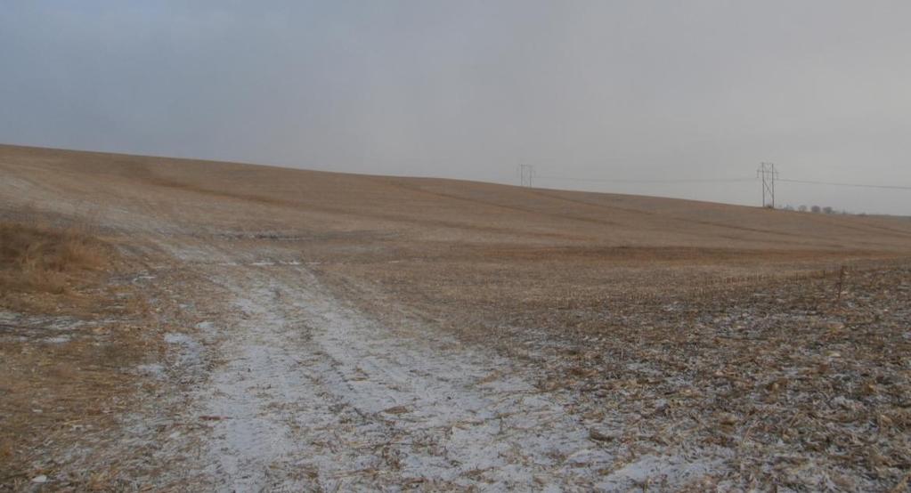
5 Photos: Parcel 1

6 Aerial Photo: Parcel 2 Price & Terms $465,750 $5,750/acre 10% down upon acceptance of offer; balance due in cash at closing. Possession Negotiable. Real Estate Tax Taxes Payable : $1, Net Taxable Acres: Tax per Net Taxable Acre: $18.79 FSA Data Part of Farm Number 6921, Tract 4822 Crop Acres: 63.8 The base and yields on this farm are currently unavailable. Soil Types/Productivity Primary soils are Ely, Gara and Nodaway. See soil map for detail. CSR2: 70.9 per 2017 AgriData, Inc., based on FSA crop acres. CSR: 72.4 per 2017 AgriData, Inc., based on FSA crop acres. CSR: 68.1 per County Assessor, based on net taxable acres. Land Description Level to gently rolling. Comments Nice laying Iowa county farm with some recreational benefits. Property Information Parcel 2-81 Acres m/l Location From Victor at I-80 Interchange - 5 miles south on County Road V38, 1¼ miles east on 265th Street and a ½ mile south on CC Avenue. The farm is located on the west side of the road. Legal Description The SW ¼ of the SW ¼ of Section 28 and the NW ¼ of the NW ¼ of Section 33; all located in Township 79 North, Range 12 West of the 5 th P.M., Iowa County, Iowa.

7 Soil Map: Parcel 2 Measured Tillable Acres 61.6 Avg. CSR: 72.4 Avg. CSR2: 70.9 Percent Non_Irr Soil Label Soil Name CSR CSR2 of Field Class Acres 1220 Nodaway silt loam, shallow loess, % Vw B Waukee loam, 2 to 5 percent slopes % IIs D2 Gara loam, 9 to 14 percent slopes, % IVe Nodaway silt loam, shallow loess, % IIw C2 Shelby loam, 5 to 9 percent slopes, % IIIe B Ely silty clay loam, 2 to 5 percent % IIe B Ackmore-Colo complex, 2 to % IIw Watkins silt loam, 0 to 2 percent % I Koszta silt loam, 0 to 2 percent % Ie C Ladoga silt loam, 5 to 9 percent % IIIe C2 Ladoga silt loam, 5 to 9 percent % IIIe B Ladoga silt loam, terrace, 2 to % IIe 4.9
8 Photos: Parcel 2

9 Aerial Photo: Parcel 3 - SOLD Property Information Parcel 3-45 Acres m/l SOLD! Location From Victor at I-80 Interchange - 7½ miles south on County Road V38 to 286th Street. The farm is located in the southeast corner of this intersection. Legal Description That part of the S ½ of the SW ¼ lying South of the road in Section 5, Township 78 North, Range 12 West of the 5 th P.M., Iowa County, Iowa. Price & Terms $375,750 $8,350/acre 10% down upon acceptance of offer; balance due in cash at closing. Possession Negotiable. Real Estate Tax Taxes Payable : $1, Net Taxable Acres: Tax per Net Taxable Acre: $29.14 FSA Data Part of Farm Number 6921, Tract 5224 Crop Acres: 44.5 Corn Base: 23.9 Corn PLC Yield: 110 Bu. Bean Base: 17.9 Bean PLC Yield: 35 Bu. Oat Base: 2.7 Oat PLC Yield: 44 Bu. Soil Types/Productivity Primary soils are Nodaway, Koszta and Chequest. See soil map for detail. CSR2: 78.7 per 2017 AgriData, Inc., based on FSA crop acres. CSR: 81.9 per 2017 AgriData, Inc., based on FSA crop acres. CSR: 78.8 per County Assessor, based on net taxable acres. Land Description Level. Comments High CSR, Iowa County farm located along a hard surface road.

10 Soil Map: Parcel 3 - SOLD Measured Tillable Acres 44.5 Avg. CSR: 81.9 Avg. CSR2: 78.7 Percent Non_Irr Soil Label Soil Name CSR CSR2 of Field Class Acres 1220 Nodaway silt loam, shallow loess, % Vw Nodaway silt loam, shallow loess, % IIw B Ely silty clay loam, 2 to 5 percent % IIe Ackmore silt loam, 0 to 2 percent % IIw Chequest silt loam, 0 to 2 percent % IIw Koszta silt loam, 0 to 2 percent % Ie C Ladoga silt loam, terrace, 5 to % IIIe D2 Ladoga silt loam, terrace, 9 to % IIIe Nevin silty clay loam, 0 to 2 percent % Iw 1.2

11 Photos: Parcel 3 - SOLD

12 Make the Most of Your Farmland Investment Real Estate Sales and Auctions Professional Buyer Representation Professional Farm Management Certified Farm Appraisals
131 ACRES M/L VAN BUREN COUNTY, IOWA LISTING #458 JIM KEDLEY. C: O:
 131 ACRES M/L VAN BUREN COUNTY, IOWA LISTING #458 JIM KEDLEY C: 563-212-5401 O: 563-659-8185 Jimkedley@totalrealtyco.com CWC Holdings LLC, 131 Acres M/L, Van Buren County, IA TOTAL ACRES: 131 MOL PRICE:
80 ACRES M/L CEDAR COUNTY, IA LISTING #465 DOUGLAS R. YEGGE ALAN MCNEIL. C: O:
 80 ACRES M/L CEDAR COUNTY, IA LISTING #465 DOUGLAS R. YEGGE C: 563-320-9900 O: 563-659-8185 total@totalrealtyco.com ALAN MCNEIL C: 563-321-1125 O: 563-659-8185 alan@totalrealtyco.com Kroemer, 80 Acres
LAND FOR SALE 82 ACRES M/L CEDAR COUNTY, IOWA LISTING # DOUGLAS R. YEGGE C: O:
 LAND FOR SALE LISTING #13968 82 ACRES M/L CEDAR COUNTY, IOWA DOUGLAS R. YEGGE C: 563-320-9900 O: 563-659-8185 Doug@PeoplesCompany.com ALAN MCNEIL C: 563-321-1125 O: 563-659-8185 Alan@PeoplesCompany.com
LAND FOR SALE 30 ACRES M/L FLOYD COUNTY, IOWA LISTING # DOUGLAS R. YEGGE C: O:
 LAND FOR SALE LISTING #13886 30 ACRES M/L FLOYD COUNTY, IOWA DOUGLAS R. YEGGE C: 563-320-9900 O: 563-659-8185 Doug@PeoplesCompany.com ALAN MCNEIL C: 563-321-1125 O: 563-659-8185 Alan@PeoplesCompany.com
FARMLAND AUCTION. FSA INFORMATION: Farmland: acres Cropland: acres Tillable: acres
 FARMLAND AUCTION January 22, 2019 at 10:30 am Keep an eye on BarnesRealty.com for possible blizzard date of 1/24/2019 Fisher Community Center, 201 E. Iowa St. Hiawatha, KS 66434 Here is a very productive
LAND FOR SALE 314 ACRES M/L BERG, WORTH COUNTY, IOWA LISTING # DOUGLAS R. YEGGE C: O:
 LAND FOR SALE LISTING #13870 314 ACRES M/L BERG, WORTH COUNTY, IOWA DOUGLAS R. YEGGE C: 563-320-9900 O: 563-659-8185 Doug@PeoplesCompany.com ALAN MCNEIL C: 563-321-1125 O: 563-659-8185 Alan@PeoplesCompany.com
365.8 Acres +/- Brown County, KS February 28, 2019 at 10:30 am Community Building, 511 West Front Street, Fairview, KS
 Farmland Auction February 28, 2019 at 10:30 am Community Building, 511 West Front Street, Fairview, KS This excellent Brown County farm is just North of Fairview, KS and it will be selling in 3 tracts
G T12 G J44 G J46 ST 2. Jerome. Martinstown. Numa. A Maryanna F. Wallin Estate Appanoose County, Iowa
 135th Ave 150th Ave 153rd Ave Elm St N 170th Ave 171st Ave 172nd St 175th Ave 51 0th St Highw ay 2 Highw ay 2 ST 2 Highw ay 2 G T12 135th Ave 522nd St 523rd St Jerome 140th Ave 524th St 1 2 G J44 3 160th
LAND AUCTION. Open House: Saturday, August 6th and Saturday, August 20th From 9:00 AM to 11:00 AM at 1220 C Avenue, Scranton, Iowa
 L-1005 LAND AUCTION 1,235+/- Acres, Carroll and Greene Counties, Iowa Friday, August 2, 201 10:00 AM at the Saint Joseph s Parish Center 501 North Locust Street Jefferson, Iowa Highlight Features: Over
Demoss Farm & Home 118 Acres, M/L W. 209th Ave. Pattonsburg, Mo 64670
 118 Acres, M/L 39436 W. 209th Ave. Pattonsburg, Mo 64670 PRICE: $400,000.00 LAND USE: FSA shows approx. 118.32 farmland acres, ml, of which there were 36.47 acres of effective cropland with the remainder
80 ACRES M/L BOONE COUNTY, IOWA LISTING # Pilot Mound, Iowa. I Avenue. 130th Street. Co Hwy P th Street
 Co Hwy P70 I Avenue 80 ACRES M/L BOONE COUNTY, IOWA CAPTION Pilot Mound, 130th Street 130th Street LISTING #12320 New Listing Price! $800,000 DESCRIPTION: High Quality Farm in Strong Farming Area and potential
Auction Location Eagles Club 316 S. 2 nd Street, Aberdeen, SD
 Auction Location Eagles Club 316 S. 2 nd Street, Aberdeen, SD Welcome We would like to invite and welcome you to our public auction! This is an excellent opportunity to add Brown County cropland to your
State: Kansas County: Sherman Location: S-037W Township: Union Acres: Date: 12/19/2011. Maps provided by:
 Soils Map State: Kansas County: Sherman Location: 007-009S-037W Township: Union Acres: 147.8 Date: 12/19/2011 Fsa borders provided by the Farm Service Agency as of May 23, 2008. Soils data provided by
Land Sales Specialists Setting the trend for how Real Estate is sold in the Midwest.
 Land Sales Specialists Setting the trend for how Real Estate is sold in the Midwest. www.barnesrealty.com 18156 Hwy 59 Mound City, MO 64470 (660) 442-3177 1711 Oregon Hiawatha, KS 66434 (785) 742-4580
For Sale at $290,000.00
 We are pleased to present Stearns Property 77± Acres Forest Township, Rice County For Sale at $290,000.00 Listing Agent: Charles Wingert Office: 507-345-LAND (5263) Toll Free: 800-730-LAND (5263) Direct:
Farmland For Sale 3 Tracts /- acres Webster County, Iowa Section 31, T88N, R30W & Section 33, T88N, R29W
 Farmland For Sale 3 Tracts 316.02 +/- acres Webster County, Section 31, T88N, R30W & Section 33, T88N, R29W Contact Martin today! 309-242-7299 mthornton@hbtbank.com Martin G. Thornton, Broker 200 W. College
Tract 1. Tract 3. Tract 2. Tract 4. A Taylor Co., IA
 Newport Ave Sec. 7 Sec. 8 235th St Sec. 13 250 th St Sec. 18 Maryl and Ave Sec. 17 T68N R34W T68N R33W 250 th St Sec. 24 257t h St Sec. 19 2 Newp ort Way Sec. 20 Sec. 25 Latitude: 40.6872 N Longitude:
173 ACRES - RILEY COUNTY, KS
 Buyers, Sellers & Land Connected PRICE: $690,000 ACRES: 173 COUNTY: RILEY STATE: KANSAS First Class Hunting with Outstanding Income Potential If you have ever dreamed of owning your very own piece of first
House & 3.21 Acres, Linn County, IA. 927 Linn Ridge Road, Mount Vernon, Iowa 52314
 ACREAGE FOR SALE House & 3.21 Acres, Linn County, IA 927 Linn Ridge Road, Mount Vernon, Iowa 52314 Property Information Location From Mount Vernon: Four miles north on Springville Road and one mile west
Pifer s. 1, /- Acres Clay County, MN. Written Bid. Land For Lease. WRITTEN BIDS DUE BEFORE: Friday, January 19, :00 p.m.
 1,666.53 +/- Acres Clay County, MN Written Bid Land For Lease WRITTEN BIDS DUE BEFORE: Friday, January 19, 2018 5:00 p.m. OWNER: Hogetvedt Family Rev Trust STOCK PHOTO General Information Land Lease Auction
FARMLAND FOR SALE ± Acres 5 Tracts
 Now is your chance to acquire productive farmland in Greene County, Illinois. Greene County, IL FARMLAND FOR SALE 756.08± Acres 5 Tracts Highly productive riverbottom farms Heavily improved with tiling
/- Acres Becker County, MN (see pgs 1-6) /- Acres Clay County, MN (see pgs 8-14) Pifer s Written Bid.
 /- Acres Clay County, MN (see pgs 8-14) Pifer s Written Bid.") 812.02 +/- Acres Becker County, MN (see pgs 1-6) 810.14 +/- Acres Clay County, MN (see pgs 8-14) Written Bid Land For Lease WRITTEN BIDS DUE BEFORE: Friday, December 8, 2017 5:00 p.m. OWNERS: Case Agricultural
812.02 +/- Acres Becker County, MN (see pgs 1-6) 810.14 +/- Acres Clay County, MN (see pgs 8-14) Written Bid Land For Lease WRITTEN BIDS DUE BEFORE: Friday, December 8, 2017 5:00 p.m. OWNERS: Case Agricultural
Deuel County Dryland
 Deuel County Dryland Two parcels of dryland farm ground near Lewellen, NE Property Highlights List Price $852,474 $786,877 Location 12-15 miles south of Lewellen, Ne or the same distance from Big Springs,
WALKER FEEDLOT Total taxable acres, part fenced. 4 homes & multiple nice/modern outbldgs hd feedyard with sprinklers a-shkd-0002
 ABILENE WALKER FEEDLOT 38.7 Total taxable acres, part fenced 4 homes & multiple nice/modern outbldgs 3500 hd feedyard with sprinklers a-shkd-0002 Center pivot irrigation from lagoons 999 hd feedlot A-SHDK-B020
Northeast Perkins County Pivots
 Northeast Perkins County Pivots 315.9± acres of center pivot irrigated farmland Southeast of Paxton, NE Email: Jordan@lashleyland.com Property Highlights List Price $1,550,000 Location Southeast of Paxton,
FOR SALE HILL FAMILY FARM WATKINS CORNER, AR. Phillips County, Arkansas: 2,300+/- Acre Irrigated Grain Farm NEW PRICE/YIELD UPDATES:
 SOLD FARMLAND ADVISORS FOR SALE HILL FAMILY FARM WATKINS CORNER, AR 2,300+/- Acres - Phillips County, Arkansas $10,950,000 Phillips County, Arkansas: 2,300+/- Acre Irrigated Grain Farm NEW PRICE/YIELD
FOR SALE NEW PRICE HILL FAMILY FARM WATKINS CORNER, AR. Phillips County, Arkansas: 2,300+/- Acre Irrigated Grain Farm NEW PRICE/YIELD UPDATES:
 NEW PRICE FARMLAND ADVISORS FOR SALE HILL FAMILY FARM WATKINS CORNER, AR 2,300+/- Acres - Phillips County, Arkansas $10,950,000 Phillips County, Arkansas: 2,300+/- Acre Irrigated Grain Farm NEW PRICE/YIELD
LAND FOR SALE. Beautiful Farmstead. Pifer s. Price: $1,250, /- Acres Green County, WI
 Beautiful Farmstead LAND FOR SALE 176 +/- Acres Green County, WI Price: $1,250,000 Auction & Realty - Robert Scott Pifer, Broker (#56685-90) RE Entity License #937110-91, Auction Company License #429-53
+/- 60 AC LAND FOR SALE HARLEY ROAD, ELBURN, IL 60119
 Land For Sale OFFERING SUMMARY Sale Price: $660,000 Price / Acre: $11,000 PROPERTY OVERVIEW +/- 60 acres available for purchase on the west side of Harley Road, South of Rt. 38. This site has Harley Road
SW CORNER ROUTE 38 AND HARLEY ROAD SW CORNER ROUTE 38 & HARLEY ROAD, KANE COUNTY, IL 60119
 REDUCED: Land For Sale SW CORNER ROUTE 38 AND HARLEY ROAD REDUCED: 124 AC ON IL ROUTE 38 OFFERING SUMMARY Sale Price: $1,643,000 Price / Acre: $13,250/AC PROPERTY OVERVIEW This 124 AC parcel has approximately
2016 Iowa FFA Soils Evaluation CDE Exam
 2016 Iowa FFA Soils Evaluation CDE Exam 1. Which of the following is true regarding soil horizons? a. A horizon is darker in color and has more organic matter b. B horizon is darker in color and has more
Rural Soils Career Development Event
 Rural Soils Career Development Event Effective August 1, 2014 Important Note: Please thoroughly read the Introduction and General Rules Section at the beginning of this handbook for complete rules and
Aerial Map. map center: 38 0' 55.53, ' S-4E Franklin County Illinois
 Aerial Map map center: 38 0' 55.53, -88 42' 58.78 0ft 594ft 1188ft 11/24/2016 Field borders provided by Farm Service Agency as of 5/21/2008. Soils data provided by University of at Champaign-Urbana. Topography
Colusa County Almonds
 Morgan Houchin. 3430 Unicorn Road Bakersfield, CA 93308 mobile office efax 526.97 +/- Acres of Colusa County Almonds Cork McIsaac, Broker. Broker License No. 01216717 P.O. Box 1076 West Sacramento, CA
Harding Real Estate Vacant Acres Thompson Rd., Woodstock, IL
 Harding Real Estate 325.31 Vacant Acres Thompson Rd., Woodstock, IL Randy Erwin, Broker Associate Natalie Torres, Broker Associate BHHS Starck Real Estate 1710 South Eastwood Dr. Woodstock, IL. 60098 Randy@RandyErwin.com
2014 Iowa FFA Soil Judging CDE Exam
 2014 Iowa FFA Soil Judging CDE Exam 1. Landscape position is one aspect of evaluating the surface features of a certain tract of land. Identifying the correct landscape position will indicate: a. If the
We are pleased to present Leonard Thorston Revocable Trust ± Acres Charleston Township, Redwood County
 We are pleased to present Leonard Thorston Revocable Trust 158.72 ± Acres Charleston Township, Redwood County PARCEL 1 PARCEL 2 This property to be sold by Sealed Bid Auction Owner: Leonard Thorston Family
FOR SALE. Arvin Edison Vineyard & Open Land Gross Acres Kern County, CA
 Arvin Edison Vineyard & Open Land FOR SALE Property Highlights Arvin Edison Water Storage District Class I and II Soils Neighboring properties planted to almonds, vineyards, and citrus The information
280 ACRES - HOWELL COUNTY, MO
 PRICE: $434,700 ACRES: 280 COUNTY: HOWELL STATE: MISSOURI For more information contact: KYLE ORF, Land Agent 417.988.3333 KyleOrf@MidwestLandGroup.com MidwestLandGroup.com 100 280ACRES ACRES- -COUNTY,
FOR SALE Kimberlina & Wallace Road Kern County, Ca
 Pistachio Orchard FOR SALE Kimberlina & Wallace Road Kern County, Ca The information contained herein may have been obtained from sources other than ASU Commercial. We have not verified such information
John R Trainor Park Bidwell Park Bidwell-Sacramento River SP SITE Lake Oroville State Rec Area Alpine Park
 FIGURES 1. Site Vicinity Map 2. Site Map Showing Compost Pad Layout and Facility Features 3. Wells Within One Mile of Facility and Groundwater Basin Contour Map 4. Geologic Map 5. Soils Map 6. Zoning Map
FOR SALE ± ACRES VALENTINES, VIRGINIA Price: $150,000
 LATITUDE & LONGITUDE 36.566924, -77.764781 Features STRONG RECREATIONAL INVESTMENT opportunity located south of Triplet with access from VSR 600 (Triplet Rd.) to the north. TRACT HAS BEEN RECENTLY CUTOVER
We are pleased to present Delwyn Spronk Farm ± Acres Elmer Township, Pipestone County
 We are pleased to present Delwyn Spronk Farm 79.09 ± Acres Elmer Township, Pipestone County SUBJECT PROPERTY This property to be sold by Sealed Bid Auction Owner: Delwyn & Julie Spronk Owner s Attorney:
Unit II Soil Management
 Unit II Soil Management Lesson 2: Using Soil Survey Manuals Soil survey manuals provide useful information for grassland management. Soil scientists evaluate the soil for chemical and physical properties,
Northeast Gateway Revitalization Plan
 Prepared by: Carrie Kruse, Office of Economic Development, 400 Robert D. Ray Drive, Des Moines, IA 50309 Phone: 515/283-4012 Return Address: City Clerk City Hall, 400 Robert D. Ray Drive, Des Moines, IA
Bull Canyon Ranch 2750 BULL CANYON ROAD, SANTA MARIA, CALIFORNIA PRESENTED FOR SALE BY: Rincon corporation
 Bull Canyon Ranch 2750 BULL CANYON ROAD, SANTA MARIA, CALIFORNIA PRESENTED FOR SALE BY: Rincon corporation THE FULL SERVICE REAL ESTATE COMPANY FOR THE AGRICULTURAL COMMUNITY Bull canyon ranch, santa maria
BILL NO ORDINANCE NO. 5238
 BILL NO. 5383 ORDINANCE NO. 5238 AN ORDINANCE VACATING VARIOUS STREET PROPERTIES OF THE CITY OF RICHMOND HEIGHTS, MISSOURI, ST. LOUIS COUNTY; DESCRIBED GENERALLY AS PART OF ABERDEEN AVENUE (AKA AS STOCKARD
STATE TAX COMMISSION OF MISSOURI ASSESSOR MANUAL
 STATE TAX COMMISSION OF MISSOURI ASSESSOR MANUAL CHAPTER: REVISION DATE: 10/1/2008 Page 1 of 18 7.3 The purpose of this section of the Assessor s Manual is to supplement the State Tax Commission s published
City of Grande Prairie Development Services Department
 City of Grande Prairie Development Services Department ROYAL OAKS NORTH OUTLINE PLAN OP-07-03 NW 35-71-6 W6M May 7, 2007 Royal Oaks North Outline Plan TABLE OF CONTENTS 1.0 INTRODUCTION........ 3 1.1 Purpose
2017 Iowa FFA Soil Judging CDE Exam
 2017 Iowa FFA Soil Judging CDE Exam 1. Landscape positions vary in soil composition and makeup. What landscape position would be characterized by having strata and lenses of different textures in the profile:
Richfield Prunes, Pistachios & Walnuts
 AG-LAND Investment Brokers 275 Sale Lane Red Bluff, CA 96080 530-529-4400 Fax 530-527-5042 Richfield Prunes, Pistachios & Walnuts 210 +/- acres 3 Parcels Corning, CA - Tehama County jsubject AG-LAND
Architectural Inventory Form
 COLORADO CULTURAL RESOURCE SURVEY Page 1 of 8 Official Eligibility Determination (OAHP use only) Rev. 9/98 OAHP1403 Date Initials Determined Eligible National Register Determined Not Eligible National
II We Fall-plow or Spring-plow
 II We Fall-plow or Spring-plow r,n Illinois? an JU L 11 R. S. SMITH, in Soil Physics and Soi' Survey., t lllii'vl\).. THE PROBLEM wl1'eth~ 0 f I-plow or to spring-plow IS an especially difficult one in
Farmland Real Estate Trends
 Farmland Real Estate Trends Farmland Values and Leasing Trends December 15, 2017 F. Howard Halderman AFM Who is Halderman? Halderman Can Help! Since 1930, people have been turning to Halderman Real Estate
Soils and their Relationship with Agriculture
 Soils and their Relationship with Agriculture Presentation created by Thomas Gallagher Modified by Hank Bignell Capital Area Agriculture and Horticulture Program Cornell University Cooperative Extension
Managing sprinkler irrigation systems
 Section L Managing sprinkler irrigation systems The circular irrigation pattern of the center pivot results is illustrated in Figure L-1. The system is a typical seven to eight span pivot with span widths
Rezoning. Rezone from A-1 to RH to create 9 suburban single family residential lots. Approval to Proceed
 City of Surrey PLANNING & DEVELOPMENT REPORT Rezoning Proposal: Rezone from A-1 to RH to create 9 suburban single family residential lots. Recommendation: Approval to Proceed Location: 18712 and Portion
We are pleased to present
 We are pleased to present Zenk Farms 57 ± Acres Lowville Township, Murray County 80 ± Acres Lowville Township, Murray County 150 ± Acres Mason Township, Murray County 150.31 ± Acres Slayton Township, Murray
# Photo 1 of 2. Pin: Sale Date: 05/31/17 Sale Price: $235,000 Acres: 5.66 Net Classification: Agriculture
 Pin: 6-27--7 Sale Date: 5/3/7 Sale Price: $235, Acres: 5.66 Net Classification: Agriculture 6-27--7 #739.6 Photo of 2 2 NEW DWELLING # -Office PDF+PIN: +6-27--7 2228 HWY 7, Buena Vista County Assessor
City of Grande Prairie Development Services Department KENNEDY DEVELOPMENTS LTD. OUTLINE PLAN OP-09-01
 City of Grande Prairie Development Services Department KENNEDY DEVELOPMENTS LTD. OUTLINE PLAN OP-09-01 July 27, 2009 TABLE OF CONTENTS 1.0 Introduction... 1 1.1 Plan Area Location & Context... 1 1.2 Ownership
Sacramento River Farmland Anderson, California
 AG-LAND INVESTMENT BROKERS 275 Sale Lane / P. O. Box 896 Red Bluff, CA 96080 530.529.4400 office / 530.527.5042 fax Sacramento River Farmland Anderson, California Property: 43 +/- acres of farmland with
Description of Preferred Alternative
 Chapter 2 Description of Preferred Alternative 2.1 Introduction This chapter of the programmatic Sammamish Town Center Sub-area Plan Final EIS provides a more detailed description of the Preferred Alternative
IOWA FFA STATE SOILS CDE SATURDAY, OCTOBER 13, 2007 AMES, IOWA
 IOWA FFA STATE SOILS CDE SATURDAY, OCTOBER 13, 2007 AMES, IOWA 1. Moderately sloping has what percent slope: a. 9-14% b. 2-5% c. 5-9% d. over 14% 2. Which of the following horizons is the loose underlying
Architectural Inventory Form
 OAHP1403 Rev. 9/98 COLORADO CULTURAL RESOURCE SURVEY Architectural Inventory Form Official eligibility determination (OAHP use only) Date Initials Determined Eligible- NR Determined Not Eligible- NR Determined
Land Capability Classifications
 Land Capability Classifications Unit: Soil Science Problem Area: Basic Principles of Soil Science Student Learning Objectives. Instruction in this lesson should result in students achieving the following
Land for Sale. Marion County, Georgia. $2,160,000 +/- 900 Acres $2,400 per Acre
 Land for Sale Marion County, Georgia 2 Contents Property Fact Sheet... 3 Regional Map... 4 Local Map... 5 Aerial Map... 6 Major Soil Types Map... 7 Soil Classification Map... 8 Soil Classification Table...
Soil Survey of San Luis Obispo County, California Paso Robles Area
 United States Department of Agriculture Soil Conservation Service In cooperation with University of California Agricultural Experiment Station Soil Survey of San Luis Obispo County, California Paso Robles
M E M O R A N D U M November 9, 2018
 M E M O R A N D U M November 9, 2018 To: Southlake 2035 Corridor Planning Committee From: Kenneth Baker, Sr. Director of Planning and Development Services Subject: Item #8 Up to thirteen (13) residential
Colerain Township report to. Hamilton County Regional Planning Commission. December 2, 2010, 1:00PM. t a f f r e p o r t
 Colerain Township report to Hamilton County Regional Planning Commission December 2, 2010, 1:00PM Preliminary Plan: Case No.: ZA2001-04, Forevergreen Prepared By: Amy Bancroft, Land Use Planner t a f f
General Location Annex, Rezone & Preliminary Plat Lansdowne Addition, Unit Three
 NEWFOUNDLAND I-5 Agricultural District Subject Site SUNDANCE ANDERSON Single Family Residential CHRISTY PUD Agricultural District Highway Business General Location Annex, Rezone & Preliminary Plat Lansdowne
Darlington Pines 1,295. At a Glance: Property Features. Acreage: 622 +/- acres (Sub-dividable) Asking Price:
 Asking Price:") ONLY $ 1,95 PER ACRE Property Features Located in the fertile northern reaches of Holmes County, Florida, the 6-acre tract has been continuously owned by the Spann family for over 50 years, once serving
ONLY $ 1,95 PER ACRE Property Features Located in the fertile northern reaches of Holmes County, Florida, the 6-acre tract has been continuously owned by the Spann family for over 50 years, once serving
Subject: 30 Otis Street, Evaluation of Shadow on Proposed 11th and Natoma Park
 Date: September 5, 2018 To: Recreation and Park Commission Capital Committee Through: Philip A. Ginsburg, General Manager Toks Ajike, Director, Capital & Planning Division From: Brian Stokle, Planner,
September 20, 2016 Soils Investigation for Agricultural Designation Windemere Place, Missoula County, Montana
 September 20, 201 Soils Investigation for Agricultural Designation Windemere Place, Missoula County, Montana The purpose of this report is to compare on-site soils of the proposed subdivision with the
COMPANY JERALD WINETROUB COMPANY
 LAKELINE PROPERTIES Austin & Cedar Park, Texas JOHN L COMPANY REAL ESTATE INVESTMENTS JOHN C. LEWIS PRESIDENT 1717 WEST 6TH STREET, SUITE390 AUSTIN, TEXAS 78703 TEL (512) 476-7011 CELL (512) 413-8100 john
Horner-McLaughlin Woods: Soil Types
 Horner-McLaughlin Woods: Soil Types Not present at HMW Adrian Muck Conover Loam 0-4% Slopes Houghton Muck Miami Loam 2-6% Slopes Miami Loam 6-12% Slopes Miami Loam 12-18% Slopes t 0 0.125 0.25 Miles Mary
SUNSET CORRIDOR LAND. The property is now available and ready for corporate utilization, development or investment.
 SUNSET CORRIDOR LAND The property is now available and ready for corporate utilization, development or investment. This 275-acre site is now available and ready to develop. Just off US 26, this west Sunset
Land for Sale. Baker County, Georgia. $4,960,000 1,984 Acres $2,500 per Acre
 Land for Sale Baker County, Georgia $4,960,000 1,984 Acres $2,500 per Acre 2 Contents Property Fact Sheet... 3 Regional Map... 4 Local Map... 5 Aerial Map... 6 Major Soil Types Map... 7 Soil Classification
City of Sun Prairie Wetland Buffer Reduction Request
 City of Sun Prairie Wetland Buffer Reduction Request Westside Development Area January 9, 2017 Prepared by: City of Sun Prairie 300 E. Main Street Sun Prairie, WI 53590 BACKGROUND The City of Sun Prairie
WEST HILL BUSINESS PARK AREA STRUCTURE PLAN
 MUNICIPAL DISTRICT OF PEACE NO. 135 WEST HILL BUSINESS PARK AREA STRUCTURE PLAN Prepared by: TABLE OF CONTENTS 1.0 Introduction... 1 1.1 Purpose of Plan........ 1 1.2 Plan Area..... 1 1.3 Existing Conditions...
ARTICLE XXXIII (O) OJUS URBAN AREA DISTRICT
 OJUS URBAN AREA DISTRICT") Page 1 ARTICLE XXXIII (O) OJUS URBAN AREA DISTRICT Sec. 33-284.99.14 Purpose, intent and applicability. A. The regulations contained in this chapter and Chapter 18A, Landscape Code, Code of Miami-Dade
Page 1 ARTICLE XXXIII (O) OJUS URBAN AREA DISTRICT Sec. 33-284.99.14 Purpose, intent and applicability. A. The regulations contained in this chapter and Chapter 18A, Landscape Code, Code of Miami-Dade
Architectural Inventory Form
 COLORADO CULTURAL RESOURCE SURVEY Page 1 of 7 Official Eligibility Determination (OAHP use only) Rev. 9/98 OAHP1403 Date Initials Determined Eligible National Register Determined Not Eligible National
FOR SALE. Reedley Apricot Ranch ± Acres Fresno County, California. CA BRE #
 FOR SALE Reedley Apricot Ranch 126.89± Acres Fresno County, California Exclusively Presented By: Pearson Realty Majority of soils are Grade 1 Seven apricot varieties Consolidated Irrigation District CALIFORNIA
Urban Planning and Land Use
 Urban Planning and Land Use 701 North 7 th Street, Room 423 Phone: (913) 573-5750 Kansas City, Kansas 66101 Fax: (913) 573-5796 Email: planninginfo@wycokck.org www.wycokck.org/planning To: From: City Planning
USE OF PRECISION AGRICULTURE TECHNOLOGY TO EVALUATE SOIL COMPACTION
 USE OF PRECISION AGRICULTURE TECHNOLOGY TO EVALUATE SOIL COMPACTION R. Goodson R. Letlow, D. Rester, and J. Stevens AUTHORS:Louisiana CooperativeExtension Service, LSU AgCenter P.O. Box 25100, Baton Rouge,
Parcel:
 Katrina S. Scarborough, CFA, CCF, MCF Osceola County Property Appraiser www.property-appraiser.org Osceola County Government Center 2505 East Irlo Bronson Memorial Hwy, Kissimmee, FL 34744 Ph: (407) 742-5000
4 Homes & Vacant Lot
 1102 W. Broadway Ave. Enid, OK 580.237.7174 580.234.7800 Fax 4 Homes & Vacant Lot USED HOSPITAL & OFFICE EQUIPMENT WEDNESDAY DECEMBER 16 th 10A.M. AUCTION LOCATION: Kingfisher Middle School Auditorium,
The South Macleod Trail Community and Employment Centre
 The South Macleod Trail Community and Employment Centre Community and Neighbourhood Planning Module Context During the 1950s, the movement of people away from urban centres led to the evolution of the
FOR SALE ± Acres Fresno County, California. CA BRE # Exclusively Presented By: Pearson Realty
 FOR SALE Orange Cove Citrus Ranch with Custom Home 127.33± Acres Fresno County, California Exclusively Presented By: Pearson Realty Variety of Citrus Plantings Frost Protection District and Well Water
2012 FINAL SOILS AREA 2 Envirothon Questions Answer KEY
 2012 FINAL SOILS AREA 2 Envirothon Questions Answer KEY Questions 1-6 to be answered at the soil pit: 1. Soil scientists categorize soils by drainage classes. What is the drainage class of the soil at
Ranson,West Virginia LAND DEVELOPMENT PLAN AND PLAT APPLICATION MARCH 12, 2012
 C L A Y H I L L F A R M Ranson,West Virginia LAND DEVELOPMENT PLAN AND PLAT APPLICATION MARCH, OWNER / APPLICANT Strider, LLC Brandywine Drive Charlottesville, VA APPLICATION PREPARATION PlaceMakers, LLC
Umatilla River $1,650,000
 Forth Ranch Umatilla River $1,650,000 The Whitney Land Company Robin Fletcher, Broker 101 S.E. Third, Pendleton, OR 97801 (541) 278-4444; farms@whitneylandcompany.com www.whitneylandcompany.com This property
Micco Park Village Development
 FOR SALE Call For Pricing Micco Park Village Development Proposed Project Property Details Micco Park Village Development PRICE Call For Pricing A monumental development opportunity of a lifetime! The
City of Surrey PLANNING & DEVELOPMENT REPORT File:
 City of Surrey PLANNING & DEVELOPMENT REPORT PROPOSAL: Development Permit Planning Report Date: July 28, 2008 Development Variance Permit to permit the construction of a concrete noise attenuation fence
Annual lease of the tillable acreage for crops (soybeans and/or corn).
.") FOR SALE $895,000.00 11201 Hill Road, Woodsboro, Maryland 21798 Crop Farm with Subdivision Potential PRESENTING Location: 11201 Hill Road, Woodsboro, MD 132.2064 acre crop farm with extraordinary views,
FOR SALE $895,000.00 11201 Hill Road, Woodsboro, Maryland 21798 Crop Farm with Subdivision Potential PRESENTING Location: 11201 Hill Road, Woodsboro, MD 132.2064 acre crop farm with extraordinary views,
SHEBOYGAN COUNTY TRANSPORTATION DEPARTMENT PLYMOUTH DISTRICT HIGHWAY SHED N6111 County Road OJ, Plymouth WI
 SHEBOYGAN COUNTY TRANSPORTATION DEPARTMENT PLYMOUTH DISTRICT HIGHWAY SHED N6111 County Road OJ, Plymouth WI AVAILABLE FALL 2017 This facility is located just North of Plymouth WI and is currently in use
Suited for Light Industrial & Manufacturing ± 343 Acres in Denton High Traffic Counts & Visibility
 Light Industrial / Manufacturing Masch Branch & Hampton Rd Suited for Light Industrial & Manufacturing ± 343 Acres in Denton High Traffic Counts & Visibility 1400 Dallas Dr. 940.390.1927 jimmy.terrell@sbpcommercial.com
Bylaw C-1262 Adopted February 6, Planning and Development Department
 Bylaw C-1262 Adopted February 6, 2012 Planning and Development Department CITY OF GRANDE PRAIRIE BYLAW C-1262 A Bylaw to adopt the Brookfield Neighbourhood Outline Plan THE MUNICIPAL COUNCIL OF THE CITY
Pits 1 & 3 Questions. 7. Subsurface: Texture (5 pts) A. Coarse B. Moderately course C. Medium D. Fine E. Very Fine
 A. Coarse B. Moderately course C. Medium D. Fine E. Very Fine") Minnesota Soils Scorecard Questions for Pits 1-4 Scantron # 105481 Use your soils scorecard to fill out the answers on your scantron Bubble in the front side of the sheet for Pit 1 (# 1-45) and Pit 2 (#51-95)
Minnesota Soils Scorecard Questions for Pits 1-4 Scantron # 105481 Use your soils scorecard to fill out the answers on your scantron Bubble in the front side of the sheet for Pit 1 (# 1-45) and Pit 2 (#51-95)
CITY OF HERMISTON DOWNTOWN URBAN RENEWAL PLAN
 CITY OF HERMISTON DOWNTOWN URBAN RENEWAL PLAN AUGUST 2013 Prepared For: CITY OF HERMISTON, OREGON By: JOHNSON REID, LLC STIVEN PLANNING & DEVELOPMENT SERVICES, LLC TABLE OF CONTENTS I. Introduction...
NYC Envirothon 2017 Soil Science Review. Richard K Shaw USDA-NRCS
 NYC Envirothon 2017 Soil Science Review Richard K Shaw USDA-NRCS Introduction Who Are We? U.S. Department of Agriculture (1862) Natural Resources Conservation Service (1935) What Do We Do? Provide leadership