SCOPING REPORT. On contract research for ILISO CONSULTING
|
|
|
- Ella Neal
- 5 years ago
- Views:
Transcription
1 SCOPING REPORT On contract research for ILISO CONSULTING Proposed Construction of a 65 MW Photovoltaic Power Plant, Duvha Power Station, Mpumalanga Province Soils and Agricultural Potential Scoping Study By D.G. Paterson (Pr. Sci. Nat /04) Report Number GW/A/2014/xx January 2015 ARC-Institute for Soil, Climate and Water, Private Bag X79, Pretoria 0001, South Africa Tel (012) Fax (012)

2 DECLARATION I hereby declare that I am qualified to compile this report as a registered Natural Scientist and that I am independent of any of the parties involved and that I have compiled an impartial report, based solely on all the information available. D G Paterson January
3 CONTENTS Page 1. TERMS OF REFERENCE 4 2. SITE CHARACTERISTICS 5 3. METHODOLOGY 6 4. SOILS 7 5. AGRICULTURAL POTENTIAL 9 6. IMPACTS 9 7. CONCLUSION 10 REFERENCES 10 APPENDIX A: MAP OF LAND TYPES 3
4 1. TERMS OF REFERENCE The ARC-Institute for Soil, Climate and Water (ARC-ISCW) was contracted by Iliso Consulting to undertake a soil investigation near Witbank (emalahleni), in Mpumalanga Province. The purpose of the investigation is to contribute to the scoping phase of the Environmental Impact assessment (EIA) process for a proposed Photovoltaic (PV) power generation facility at Eskom s Duvha Power Station. Scoping Report The scoping report must include:» a description of the environment that may be affected by the activity and the manner in which the environment may be affected by the proposed project» a description and evaluation of environmental issues and potential impacts (including direct, indirect and cumulative impacts) that have been identified» Direct, indirect and cumulative impacts of the identified issues must be evaluated within the Scoping Report in terms of the following criteria: what will be affected and how it will be affected; (limited to the immediate area or site of development), regional, national or international» a statement regarding the potential significance of the identified issues based on the evaluation of the issues/impacts» identification of potentially significant impacts to be assessed within the EIA phase and details of the methodology to be adopted in assessing these impacts. The objectives of the study are; To obtain all existing soil information and to produce a soil map of the specified area as well as To assess broad agricultural potential. 4

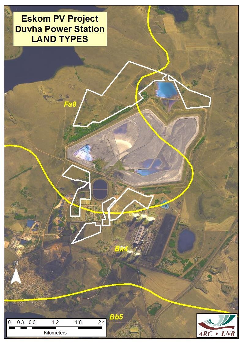
5 2. SITE CHARACTERISTICS 2.1 Location The area that was investigated, on portions of the farms Speekfontein 336JS and Rhenosterfontein 318JS, lies approximately 15 km south-east of Witbank, adjacent to the Duvha Power Station. The position of the site is shown by the green areas on the map in Figure 1. The area lies between 25 o 55 and 25 o 58 S and between 29 o 19 and 29 o 22 E. Figure 1 Locality map Of the various areas that were identified, four areas are adjacent to the Power Station, while two areas lie further north, north of the ash disposal facility at Duvha (see map in Appendix A). 2.2 Terrain The site has gentle slopes toward the west and north-west, with slopes of less than 5%, and lies at a height of approximately to metres above sea level. 5
6 The area is situated close to two watercourses (especially in the north), so potentially wet areas may well be present. 2.3 Climate The climate of the study area (Koch, 1987) can be regarded as warm to mild, with rain in summer and dry winters. The long-term average annual rainfall in this region is 680 mm, of which mm, or 85%, falls from November to April. The total annual evaporation is approximately mm per year, peaking at approximately 7.0 mm per day in December. Temperatures vary from an average monthly maximum and minimum of 27.0ºC and 13.8ºC for January to 17.5ºC and -0.8 o C for July respectively. The extreme high temperature that has been recorded is 38.9 o C and the extreme low 13.3ºC. Frost occurs most years on around 57 days on average between mid-may and mid September. 2.4 Parent Material The geology of the area comprises sandstone of the Vryheid Formation, Ecca Group (Geological Survey, 1978). 3. METHODOLOGY Existing soil information was obtained from the map sheet 2528 Pretoria (Schoeman et al., 1978) from the national Land Type Survey, published at a scale of 1: A land type is defined as an area with a uniform terrain type, macroclimate and broad soil pattern. The soils are classified according to MacVicar et al (1977). The areas under investigation (as shown in white on the map in Appendix A) are covered by two one land type, namely: Ba4 (Mainly red, highly weathered, structureless plinthic soils) Fa8 (Mainly shallow soils with no lime, and some rock) The land type boundary is shown by the yellow line in Appendix A. 6
7 It should be clearly noted that, since the information contained in the land type survey is of a reconnaissance nature, only the general dominance of the soils in the landscape can be given, and not the actual areas of occurrence within a specific land type. Also, other soils that were not identified due to the scale of the land type survey may also occur. The site was not visited during the course of this study, and so the detailed composition of the specific land types has not been ground-truthed. A summary of the dominant soil characteristics of the land types is given in Table 1 below. The distribution of soils with high, medium and low agricultural potential within each land type is also given, with the dominant class shown in bold type. 4. SOILS A summary of the dominant soil characteristics is given in Table 1 below. 7
8 Land Type Ba4 Table 1 Depth (mm) Land types occurring (with soils in order of dominance) Dominant soils Percent Characteristics of land type Hutton 14/15/16 36% Red, structureless, sandy loam to sandy clay loam soils on weathering rock Avalon/Glencoe 14/16 20% Brown to yellow-brown, structureless, sandy loam to sandy clay loam soils on mottled, soft or hard plinthite Agric. Potential (%) High: 55.6 Mod: 30.1 Low: 14.3 Fa Longlands 21/ Cartref 21/31 Hutton/Clovelly 26 Mispah 10/11 16% 36% 31% Brown to grey-brown, structureless bleached sandy loam soils on mottled soft plinthite or weathering rock Red and yellow-brown, structureless, sandy loam to sandy clay loam soils on weathering rock Brown to grey-brown, structureless sandy loam to sandy clay loam topsoils on rock or hard plinthite High: 0.0 Mod: 9.5 Low: Rock 25% 8
9 5. AGRICULTURAL POTENTIAL The area comprises a mixture of soils, mainly non-structured, with some variable depth (as can be seen from the information contained in Table 1). The high rainfall in the area (Section 2.3) means that rain-fed cultivation can be successfully practiced on suitable soils. The landscape represented by land type Ba4 is dominated by soils with high (occasionally moderate) agricultural potential, with very few low potential soils, However, the area covered by land type Fa8 is predominantly low potential, generally due to shallow soil depth and occasional rockiness. For this reason, more detailed survey investigation would be required to delineate the areas of the various soil types. This would involve carrying out a systematic soil survey of the area or areas selected as viable alternatives, using a hand-held soil auger at a grid of investigation of 150 x 150 m. Samples of topsoil and subsoil from representative soils will be collected and analyzed, so that the soils occurring can be mapped and characterized for the grade of agricultural potential. A detailed soil map and report will be prepared, with all relevant soil-related information. 6. IMPACTS The major impact on the natural resources of the study area would be the loss of arable land due to the construction of the various types of infrastructure. With the possibility of moderate to high potential agricultural soils in the vicinity, this impact would in all probability have a degree of significance, although local in extent. At the end of the project life, it is anticipated that removal of the structures would enable the land to be returned to more or less a natural state following rehabilitation, with little impact. The impact can be summarized as follows: Table 3 Nature of impact Extent of impact Impact significance Loss of agricultural land Site only Land that is no longer able to be utilized due to construction of infrastructure Confined to areas within the site where infrastructure will be located 9
10 7. CONCLUSION The area investigated is comprised of a variety of soils, but with a significant percentage of shallow soils. The area can be considered as having mainly high potential for agricultural purposes, taking into consideration the annual rainfall. The soil information used in this report is based on a reconnaissance scale survey, revealing only broad soil patterns. If more detail on the soil patterns is required, then a soil survey (see Section 5) will be necessary to determine the detailed soil patterns that might not be obvious in this report. However, since the property is owned and operated by Eskom, the use of the land for agricultural production would not likely be an option for future development and therefore not accounted for as a loss. 10
11 REFERENCES Geological Survey, : scale geological map 2528 Pretoria. Department of Mineral and Energy Affairs, Pretoria. Koch, F.G.L., Climate data. In: Land types of the maps 2526 Rustenburg and 2528 Pretoria. Mem. Agric. nat. Res. S. Afr. No. 8. Department of Agriculture and Water Supply, Pretoria. MacVicar, C.N., de Villiers, J.M., Loxton, R.F, Verster, E., Lambrechts, J.J.N., Merryweather, F.R., le Roux, J., van Rooyen, T.H. & Harmse, H.J. von M., Soil classification. A binomial system for South Africa. ARC-Institute for Soil, Climate & Water, Pretoria. Schoeman, J.L., Meldal-Johnson, A., Fitzpatrick, R.W. & Verster, E., Land types of the map 2528 Pretoria. Field information. Mem. Nat. Agric. Res. S. Afr. No. 8. ARC-Institute for Soil, Climate and Water, Pretoria. 11
12 APPENDIX A MAP OF LAND TYPES 12
13 13
SOILS AND AGRICULTURAL POTENTIAL FOR THE PROPOSED P166 SERVITUDE, MBOMBELA, MPUMALANGA PROVINCE
 REPORT On contract research for Royal Haskoning DHV SOILS AND AGRICULTURAL POTENTIAL FOR THE PROPOSED P166 SERVITUDE, MBOMBELA, MPUMALANGA PROVINCE By F.T. Seabi (Pr. Nat. Sci. 400370/11) & D.G. Paterson
SOIL SURVEY OF PORTIONS 81 AND 82 OFTHE FARM VAALBANK 512JQ, NEAR MAGALIESBURG, SOUTH-WEST OF PRETORIA
 REPORT For Newtown Landscape Architects SOIL SURVEY OF PORTIONS 81 AND 82 OFTHE FARM VAALBANK 512JQ, NEAR MAGALIESBURG, SOUTH-WEST OF PRETORIA By N.M. Mushia, D.G. Paterson and S.D. Mkula Report Number
SOIL SURVEY FOR PROPOSED WET ASH DISPOSAL FACILITY, HENDRINA POWER STATION, MPUMALANGA PROVINCE
 REPORT for Lidwala Environmental and Planning Servives by the INSTITUTE FOR SOIL CLIMATE AND WATER AGRICULTURAL RESEARCH COUNCIL SOIL SURVEY FOR PROPOSED WET ASH DISPOSAL FACILITY, HENDRINA POWER STATION,
AGRICULTURAL LAND CLASSIFICATION
 AGRICULTURAL LAND CLASSIFICATION STAINSBY HALL, MIDDLESBROUGH PROPOSED GOLF COURSE ADAS December 1990 Leeds Regional Office 2FCS 5100 CONTENTS 1. INTRODUCTION AND GENERAL SITE CHARACTERISTICS 2. AGRICULTURAL
The entire site supports grass on which sheep had been grazing recently.
 PHYSICAL CHARACTERISTICS REPORT FOR LAND AT HORSEHAY A^ Agricultural Land Classification of approximately 14 hectares of land to the southwest of Horsehay was undertaken in November 1989. The site lies
PROPOSED OPEN CAST COAL SITE SEPTEMBER 1992
 AGRICULTURAL LAND CLASSIFICATION AND STATEMENT OF PHYSICAL CHARACTERISTICS SKIERS SPRING, HOYLAND, SOUTH YORKSHIRE PROPOSED OPEN CAST COAL SITE SEPTEMBER 1992 ADAS LEEDS STATUTORY GROUP Job No. 98/92 MAFF
Report on a soil survey and agricultural suitability investigation of the property known as Erf 660, De Doorns.
 De Doorns erf 660 Soil Report 1 Report on a soil survey and agricultural suitability investigation of the property known as Erf 660, De Doorns. by F. Ellis September 2006 CONTENTS 1 INTRODUCTION AND TERMS
PHYSICAL CHAtlACTERISTICS REPORT FOR THE PROPOSED SAND AND GRAVEL SITE AT MANOR FARM, UFFINGTON
 PHYSICAL CHAtlACTERISTICS REPORT FOR THE PROPOSED SAND AND GRAVEL SITE AT MANOR FARM, UFFINGTON Introduction Following the" request for detailed information on the physical characteristics of soil at Manor
STATEMENT OF PHYSICAL CHARACTERISTICS AND AGRICULTURAL LAND CLASSIFICATION
 STATEMENT OF PHYSICAL CHARACTERISTICS AND AGRICULTURAL LAND CLASSIFICATION BIRKWOOD FARM, ALTOFTS WEST YORKSHIRE Proposed Opencast Extraction of Clay and coal ADAS January 1990 Leeds Regional Office File
Environmental Impact Assessment for KPSX: Weltevreden
 Environmental Impact Assessment for KPSX: Weltevreden Soil Survey Report Project Number: Prepared for: Billiton Energy Coal South Africa (PTY) Limited (BECSA) January 2015 Digby Wells and Associates (South
PHYSICAL CHARACTERISTICS REPORT INCORPORATING AGRICULTURAL LAND CLASSIFICATION LAND AT BOLE INGS, WESTBURTON, NOTTINGHAMSHIRE (SK805875)
") (krahs 2% I?5 PHYSICAL CHARACTERISTICS REPORT INCORPORATING AGRICULTURAL LAND CLASSIFICATION LAND AT BOLE INGS, WESTBURTON, NOTTINGHAMSHIRE (SK805875) 1.0 INTRODUCTION 1.1 The site, an area of 84.5 hectares,
(krahs 2% I?5 PHYSICAL CHARACTERISTICS REPORT INCORPORATING AGRICULTURAL LAND CLASSIFICATION LAND AT BOLE INGS, WESTBURTON, NOTTINGHAMSHIRE (SK805875) 1.0 INTRODUCTION 1.1 The site, an area of 84.5 hectares,
MAFF Ministry of Ifinil Agriculture Rsheries and Food
 MAFF Ministry of Ifinil Agriculture Rsheries and Food STATEMENT OF PHYSICAL CHARACTERISTICS AND AGRICULTURAL LAND CLASSIFICATION SHILBOTTLE COLLIERY RECLAMATION SCHEME NORTHUMBERLAND DECEMBER 1994 ADAS
If A rr Ministry of. IfiriEI. Agriculture Fisheries and Food
 If A rr Ministry of IfiriEI. Agriculture Fisheries and Food AGRJCULTURAL LAND CLASSIFICATION CLEETHORPES DISTRICT LOCAL PLAN SITE H2 (SOUTH WEST) OCTOBER 1993 ADAS Leeds Statutory Group Job No:- 164/93
STAFFORDSHIRE AND STOKE-ON- TRENT STRUCTURE PLAN Site 7: Priory Farm. Agricultural Land Classification ALC Map and Report November 1998
 STAFFORDSHIRE AND STOKE-ON- TRENT STRUCTURE PLAN Site 7: Priory Farm Agricultural Land Classification ALC Map and Report November 1998 A J Spalding Resource Planning Team RPT Reference: 008/98 & 25/RPT/Ol
AGRICULTURAL LAND CLASSIFICATION SEMI-DETAILED SURVEY EGG FARM KINGS LANGLEY HERTFORDSHIRE
 AGRICULTURAL LAND CLASSIFICATION SEMI-DETAILED SURVEY EGG FARM KINGS LANGLEY HERTFORDSHIRE AGRICULTURAL LAND CLASSIFICATION SEMI-DETAILED SURVEY EGG FARM, KINGS LANGLEY, HERTFORDSHIRE 1. BACKGROUND 1.1
STATEMENT OF PHYSICAL CHARACTERISTICS AND AGRICULTURAL LAND CLASSIFICATION WITTON PARK, COUNTY DURHAM PROPOSED QUARRY EXTENSION DECEMBER 1992

ACRE NOOK EAST QUARRY, CHELFORD, CHESHIRE. Statement of Site Physical Characteristics January 1998
 ACRE NOOK EAST QUARRY, CHELFORD, CHESHIRE Statement of Site Physical Characteristics January 1998 J M LePage Resource Planning Team RPT Reference: 084/97 & 25/RPT/0863 Northern Region FRCA Reference: EL
MAFF I^inistry of IfiriEE Agriculture Fisheries and Food
 MAFF I^inistry of IfiriEE Agriculture Fisheries and Food AGRICULTURAL LAND CLASSIFICATION BROOMY HOLM FARM, EDMONDSLEY, CO DURHAM PROPOSED GOLF COURSE DECEMBER 1993 ADAS Leeds Statutory Group JobNo:- 168/93
Environmental Regulatory Processes relating to the amendment of the Environmental Management Programme for its Elandsfontein Operations
 Environmental Regulatory Processes relating to the amendment of the Environmental Management Programme for its Elandsfontein Operations Soils, Land Use and Land Capability Impact Assessment Project Number:
Explaining a Soil Profile
 Lesson C1 3 Explaining a Soil Profile Unit C. Basic Principles of Agricultural/Horticultural Science Problem Area 1. Using Basic Soil Science Principles Lesson 3. Explaining a Soil Profile New Mexico Content
SOIL SURVEY REPORT ON SENCE de LIEU, PAARL
 SOIL SURVEY REPORT ON SENCE de LIEU, PAARL April 2016 Report compiled by: B Schloms Pr. Sci. Nat. (registration Number 400059) Contents 1 Terms of reference 2 Allocation of responsibilities 3 Description
AGRICULTURAL LAND CLASSIFICATION KNOWSLEY UDP, SITE 45.01
 AGRICULTURAL LAND CLASSIFICATION KNOWSLEY UDP, SITE 45.01 MJW WOOD ADAS Ref: 25/RPT/OOll Resource Planning Team Job No: 016/95 ADAS Statutory Group MAFF Ref: EL 25/10763 WOLVERHAMPTON rnwtaiow2to»yyje
AGRICULTURAL LAND CLASSIFICATION AND STATEMENT OF PHYSICAL CHARACTERISTICS
 AGRICULTURAL LAND CLASSIFICATION AND STATEMENT OF PHYSICAL CHARACTERISTICS DALE PIT FARM. HATFIELD VOODHOUSE PROPOSED EXTRACTION OF SAND AHD GRAVEL ADAS April 1989 Leeds Regional office File Ref: 2FCS
LAND NORTH OF TAMWORTH. Agricultural Land Classification ALC Map and Report April 1998
 LAND NORTH OF TAMWORTH Agricultural Land Classification ALC Map and Report April 1998 A,L Cooke Resource Planning Team RPT Reference: 130/97 & 25/RPT/Ol loa Northern Region FRCA Reference: EL 37/11747
AGRICULTURAL LAND CLASSIFICATION AND SOIL PHYSICAL CHARACTERISTICS LAND NEAR SHIRE HILL FARM SAFFRON WALDEN ESSEX
 AGRICULTURAL LAND CLASSIFICATION AND SOIL PHYSICAL CHARACTERISTICS LAND NEAR SHIRE HILL FARM SAFFRON WALDEN ESSEX AGRICULTURAL LAND CLASSIFICATION (ALC) AND SOIL PHYSICAL CHARACTERISTICS LAND NEAR SHIRE
AGRICULTURAL LAND CLASSIFICATION AND STATEMENT OF SOIL PHYSICAL CHARACTERISTICS EXTENSION TO CLOUD HILL QUARRY, BREEDON ON THE HILL, LEICESTERSHIRE
 AGRICULTURAL LAND CLASSIFICATION AND STATEMENT OF SOIL PHYSICAL CHARACTERISTICS EXTENSION TO CLOUD HILL QUARRY, BREEDON ON THE HILL, LEICESTERSHIRE 1.0 BACKGROUND 1.1 A site of approximately 14.5 ha in
AGRICULTURAL LAND CLASSIFICATION GREAT GRIMSBY LOCAL PLAN SITE AG 2. GREAT COATES AUGUST 1993
 AGRICULTURAL LAND CLASSIFICATION GREAT GRIMSBY LOCAL PLAN SITE AG 2. GREAT COATES AUGUST 1993 ADAS Job No:- 131/93 Leeds Statutory Group MAFF Ref- EL 51/5 SUMMARY An Agricultural Land Classification survey
Agricultural Land Classification and Statement of Physical Characteristics Higbfield Farm Whitley Bridge North Yorkshire October 1996
 Agricultural Land Classification and Statement of Physical Characteristics Higbfield Farm Whitley Bridge North Yorkshire October 1996 Resource Planning Team ADAS Reference: 82/96 Leeds Statutory Group
AGRICULTURAL LAND CLASSIFICATION
 AGRICULTURAL LAND CLASSIFICATION GOOLE/HOOK LOCAL PLAN SITES SURVEYED FOR BOOTHFERRY BOROUGH COUNCIL'S INDUSTRIAL LAND SUITABILITY STUDY ADAS February 1991 Leeds Regional Office 2FCS 5205 CONTENTS 1. Introduction
Tools to facilitate the use of Soil Maps in Emilia-Romagna region (Italy) Paola Tarocco
 Paola Tarocco") Tools to facilitate the use of Soil Maps in Emilia-Romagna region (Italy) Paola Tarocco Soil maps Vs Thematic maps Soil maps are not easy to manage. Legends are usually based on soil classifications (e.g.
Tools to facilitate the use of Soil Maps in Emilia-Romagna region (Italy) Paola Tarocco Soil maps Vs Thematic maps Soil maps are not easy to manage. Legends are usually based on soil classifications (e.g.
List of Equipment, Tools, Supplies, and Facilities:
 Unit A: Principles of Soil Lesson 3: Horizons of Soil Student Learning Objectives: Instruction in this lesson should result in the students achieving the following objectives: 1. Explain a soil profile
6 Athlone Street Tel: SWELLENDAM Cell:
 C R LUBBE 6 Athlone Street Tel: 028 514 2359 SWELLENDAM Cell: 082 853 1274 6740 e-mail: macquarrie@vodamail.co.za Attention: Louise Mari van Zyl Cape EA Prac 1 June 2018 P O Box 2070 GEORGE 6530 Dear Ms
SUMMARY. alcholnie.doc\ih\jk
 SUMMARY A detailed Statement of Physical Characteristics and Agricultural Land Classification survey of ha of land at Stainton ("Holme Hall Quarry Extension") was carried out in September 1994. At the
2012 FINAL SOILS AREA 2 Envirothon Questions Answer KEY
 2012 FINAL SOILS AREA 2 Envirothon Questions Answer KEY Questions 1-6 to be answered at the soil pit: 1. Soil scientists categorize soils by drainage classes. What is the drainage class of the soil at
Explaining a Soil Profile
 Lesson C6 5 Explaining a Soil Profile Unit C. Plant and Soil Science Problem Area 6. Basic Principles of Soil Science Lesson 5. Explaining a Soil Profile Content/Process Statement: PLS3 Core Content Standard:
AGRICULTURAL LAND CLASSIFICATION AND SOIL PHYSICAL CHARACTERISTICS BIRCH PIT, NEAR COLCHESTER ESSEX
 AGRICULTURAL LAND CLASSIFICATION AND SOIL PHYSICAL CHARACTERISTICS BIRCH PIT, NEAR COLCHESTER ESSEX AGRICULTURAL LAND CLASSIFICATION AND SOIL PHYSICAL CHARACTERISTICS SEMI-DETAILED SURVEY BIRCH PIT, NEAR
AGRICULTURAL LAND CLASSIFICATION REPORT LAND AT BRANT FARM, STOURPORT-ON-SEVERN
 AGRICULTURAL LAND CLASSIFICATION REPORT LAND AT BRANT FARM, STOURPORT-ON-SEVERN INTRODUCTION 1. This report presents the findings of a detailed Agricultural Land Classification (ALC) survey on 12ha of
Annex 5D. Soil, Land Use and Land Capability Report compiled by TerraAfrica Consult, April 2015
 Annex 5D Soil, Land Use and Land Capability Report compiled by TerraAfrica Consult, April 2015 Environmental Assessment Report for the Kangra Coal (Pty) Ltd Kusipongo Resource Project: I, Mariné Pienaar,
HAVE YOU NOTICED at construction sites how a
 Explaining a Soil Profile HAVE YOU NOTICED at construction sites how a cross section of soil has a layered look? Soil near the top of the cross section is often dark, and soil below appears lighter. What
 Cci
Cci AGRICULTURAL LAND CLASSIFICATION AND STATEMENT OF PHYSICAL CHARACTERISTICS
 AGRICULTURAL LAND CLASSIFICATION AND STATEMENT OF PHYSICAL CHARACTERISTICS SEGHILL, NORTHUMBERLAND PROPOSED VASTE DISPOSAL SITE ADAS January 1989 Leeds Regional Office REF: 3/89 2FCS 4191 lds.rpg3.seghill
Explaining a Soil Profile
 Lesson A4-8: Explaining a Soil Profile Horticulture Cluster Illinois Agricultural Education Curriculum Unit A. Horticultural Science Problem Area 4. Growing Media Nutrients, and Fertilizers Lesson 8. Explaining
Humisphere SOIL RECONNAISSANCE MISSION TO 3 ESTATES IN TANZANIA. Ir. J.H.M. (Hans) Scholten
 Scholten") Humisphere SOIL RECONNAISSANCE MISSION TO 3 ESTATES IN TANZANIA Ir. J.H.M. (Hans) Scholten September 2012 CONTENT 1. INTRODUCTION 3 2. SOIL INFORMATION OBTAINED 3 3. SOILS OF KWAMDULU ESTATE. 4 3.1 Soils..
Humisphere SOIL RECONNAISSANCE MISSION TO 3 ESTATES IN TANZANIA Ir. J.H.M. (Hans) Scholten September 2012 CONTENT 1. INTRODUCTION 3 2. SOIL INFORMATION OBTAINED 3 3. SOILS OF KWAMDULU ESTATE. 4 3.1 Soils..
APPENDIX D. Slope Stability Analysis Results for Soil and Overburden Storage Mounds
 Geotechnical Assessment Report APPENDIX D Slope Stability Analysis Results for Soil and Overburden Storage Mounds DABGeot/09059GA/Final Geotechnical Assessment Report STABILITY OF SOIL AND OVERBURDEN STORAGE
M AFT Ministry of Ifin&l. Agriculture Rsheries and Food
 ^ M AFT Ministry of Ifin&l. Agriculture Rsheries and Food AGRICULTURAL LAND CLASSIFICATION BARNSLEY UDP (AREA OF SEARCH FOR AIRFIELD) SOUTH YORKSHIRE JANUARY 1995 ADAS Job No:- 9/95 Leeds Statutory Group
AGRICULTURAL LAND CLASSIFICATION VULCAN VILLAGE (PROPOSED GOLF COURSE) ST HELENS MBC
 ST HELENS MBC") AGRICULTURAL LAND CLASSIFICATION VULCAN VILLAGE (PROPOSED GOLF COURSE) ST HELENS MBC MJW WOOD ADAS Ref: 25/RPT/0709 Resource Planning Team Job No: 155/94 ADAS Statutory Group MAFF Ref: EL 25/10811 WOLVERHAMPTON
AGRICULTURAL LAND CLASSIFICATION VULCAN VILLAGE (PROPOSED GOLF COURSE) ST HELENS MBC MJW WOOD ADAS Ref: 25/RPT/0709 Resource Planning Team Job No: 155/94 ADAS Statutory Group MAFF Ref: EL 25/10811 WOLVERHAMPTON
CAVIL HEAD OCCS ACKLINGTON NOVEMBER 1997
 CAVIL HEAD OCCS ACKLINGTON Agricultural Land Classification (ALC) and Statement of Physical Characteristics Report NOVEMBER 1997 Resource Planning Team RPT Job Number: 67/97 Northern Region MAFF Reference:
HUMBLEBURN OCCS, CRAGHEAD, COUNTY DURHAM SURVEY OF RESTORED LAND OCTOBER RPT Job Number: 73/97 MAFF Reference: EL LURET Job Number: ME3RTP
 HUMBLEBURN OCCS, CRAGHEAD, COUNTY DURHAM SURVEY OF RESTORED LAND OCTOBER 1997 Resource Planning Team Northern Region FRCA, Leeds RPT Job Number: 73/97 MAFF Reference: EL 10387 LURET Job Number: ME3RTP
Also available on the web at
 2009 2000 First print Compiled by Directorate Agricultural Information Services Department of Agriculture, Forestry and Fisheries In cooperation with ARC-Institute for Tropical and Subtropical Crops Printed
AGRICULTURAL USE & QUALITY OF LAND NEAR MINDALE HOUSE PRESTATYN. Report 762/1
 AGRICULTURAL USE & QUALITY OF LAND NEAR MINDALE HOUSE PRESTATYN Report 762/1 11 th April, 2012 AGRICULTURAL USE & QUALITY OF LAND NEAR MINDALE HOUSE PRESTATYN F W Heaven, BSc, MISoilSci Report 762/1 Ltd
Land Capability Classifications
 Land Capability Classifications Unit: Soil Science Problem Area: Basic Principles of Soil Science Student Learning Objectives. Instruction in this lesson should result in students achieving the following
P/2014/00830 Received 27/06/2014 SOIL RESOURCES AND AGRICULTURAL USE & QUALITY OF LAND AT ROLLESTON PARK FARM TUTBURY, STAFFORDSHIRE.
 P/2014/00830 Received 27/06/2014 SOIL RESOURCES AND AGRICULTURAL USE & QUALITY OF LAND AT ROLLESTON PARK FARM TUTBURY, STAFFORDSHIRE Report 953/1 28 th May, 2014 SOIL RESOURCES AND AGRICULTURAL USE & QUALITY
CORNFORTH EAST QUARRY COUNTY DURHAM
 CORNFORTH EAST QUARRY COUNTY DURHAM AgricuUural Land Classification (ALC) and Statement of Physical Characteristics Report and Map MARCH 1999 Resource Planning Team RPT Job Number: 5/99 Northern Region
EXPERIMENT 6 PREPARATION OF LAND CAPABILITY CLASS MAP
 EXPERIMENT 6 PREPARATION OF LAND CAPABILITY CLASS MAP Structure 6.0 Objectives 6.1 Intnxluction 6.2 Experiment 6.21 Deciding Factors for Land Capability 6.2.2 Requirements 6.23 Procedure 6.3 Observations
STATEMENT OF PHYSICAL CHARACTERISTICS OLDWICK FARM, WEST LAVANT, WEST SUSSEX
 STATEMENT OF PHYSICAL CHARACTERISTICS OLDWICK FARM, WEST LAVANT, WEST SUSSEX STATEMENT OF PHYSICAL CHARACTERISTICS OLDWICK FARM, WEST LAVANT, WEST SUSSEX 1. BACKGROUND 1.1 This 37.1 ha site was surveyed
New horse training area, Manor Farm, Great Kimble, Buckinghamshire
 New horse training area, Manor Farm, Great Kimble, Buckinghamshire An Archaeological Watching Brief For Redwing Structures (Marlow) Limited by Andy Taylor Thames Valley Archaeological Services Ltd Site
MAFF Ministry of iflmll Agriculture Fisheries and Food
 m MAFF Ministry of iflmll Agriculture Fisheries and Food AGRICULTURAL LAND CLASSIFICATION EAST YORKSHIRE BOROUGH LOCAL PLAN (SITES AROUND DRIFFIELD) FEBRUARY 1995 ADAS Job No:- 47-54/95 Leeds Statutory
2014 Iowa FFA Soil Judging CDE Exam
 2014 Iowa FFA Soil Judging CDE Exam 1. Landscape position is one aspect of evaluating the surface features of a certain tract of land. Identifying the correct landscape position will indicate: a. If the
 108 40' 29'' W Soil Map Mesa County Area, Colorado 108 36' 55'' W 39 10' 11'' N 39 6' 31'' N 4331700 4332500 4333300 4334100 4334900 4335700 4336500 4337300 4338100 701100 701900 702700 703500 704300 705100
Request for a Scoping Opinion by Provectus. Proposed Surface Mining of Coal on Land west off the A61, Hill Top Farm, Clay Cross, Derbyshire
 Request for a Scoping Opinion by Provectus Proposed Surface Mining of Coal on Land west off the A61, Hill Top Farm, Clay Cross, Derbyshire January 2012 Contents 1 Introduction & Background... 1 2 Site
HINCKLEY AND BOSWORTH LOCAL PLAN Land south of Earl Shilton - Site G Agricultural Land Classification February 1997
 HINCKLEY AND BOSWORTH LOCAL PLAN Land south of Earl Shilton - Site G Agricultural Land Classification February 1997 Resource Planning Team ADAS Reference: 95/96n Eastern Statutory Centre MAFF Reference:
AGRICULTURAL LAND CLASSIFICATION AND STATEMENT OF SOIL PHYSICAL CHARACTERISTICS TYTTENHANGER QUARRY EXTENSION, LONDON COLNEY, HERTFORDSHIRE
 AGRICULTURAL LAND CLASSIFICATION AND STATEMENT OF SOIL PHYSICAL CHARACTERISTICS TYTTENHANGER QUARRY EXTENSION, LONDON COLNEY, HERTFORDSHIRE 1.0 BACKGROUND 1.1 The site covers an area of 42.2 ha, and is
CB1 Moderately undulating landscape with slight gilgai (few inches) formation: broad ridge tops and upper slopes of moderately shallow grey cracking
 formation: broad ridge tops and upper slopes of moderately shallow grey cracking") CB1 Moderately undulating landscape with slight gilgai (few inches) formation: broad ridge tops and upper slopes of moderately shallow grey cracking clays (Ug5.22 and Ug5.23). Associated are: (i) some
CB1 Moderately undulating landscape with slight gilgai (few inches) formation: broad ridge tops and upper slopes of moderately shallow grey cracking clays (Ug5.22 and Ug5.23). Associated are: (i) some
Relationship of Soil Moisture and Drainage Conditions to Tree Decline in Avocado Orchards *
 California Avocado Society 1943 Yearbook 28: 34-37 Relationship of Soil Moisture and Drainage Conditions to Tree Decline in Avocado Orchards * E. R. PARKER and M. B. ROUNDS Citrus Experiment Station, University
Agricultural Potential Assessment for the proposed Vlakvarkfontein Coal Mine. Mpumalanga, South Africa
 for the proposed Vlakvarkfontein Coal Mine Mpumalanga, South Africa November 2017 CLIENT Prepared for: EIMS Block 5, Fernridge Office Park, 5 Hunter Ave, Ferndale, Randburg Prepared by: The Biodiversity
Muswellbrook Coal Company No.1 Open Cut Extension Soil Study
 Muswellbrook Coal Company No.1 Open Cut Extension Soil Study November 2001 Table of Contents 1. Introduction... 1 2. Methodology... 1 3. Description of Soil Units Observed... 2 3.1 Yellow Duplex Soils
REPORT. Soil, Land Capability and Land Use Assessment Report for the Proposed New Vaal Colliery Life Extension Project.
 Rehab Green cc Registration No: 2002/094339/23 PI Steenekamp PO Box 12636 Queenswood 0121 Pretoria Cell: 082 560 0592 Fax: 086 678 1690 E-mail: rehabgreen@ee-sa.com Report No: RG/2012/03/09/1 Date: 30
SOIL RESOURCES REPORT HALVERGATE MARSHES, NORFOLK 1. BACKGROUND
 V 1,^/ R//?^ SOIL RESOURCES REPORT HALVERGATE MARSHES, NORFOLK 1. BACKGROUND 1.1 The area surveyed (a total of 33.6 hectares) comprises six fields on Halvergate Marshes, Norfolk. The water levels of these
ADy^S. Whelpley Farm, Whiteparish, Wiltshire. Resource Plaiming Team Taunton Statutory Unit. November 93
 S^Fs (S3 "S^/^S Whelpley Farm, Whiteparish, Wiltshire AGRIULTURAL LAND LASSIFIATION REPORT OF SURVEY Resource Plaiming Team Taunton Statutory Unit November 93 ADy^S WHELPLEY FARM, WHITEPARISH, WILTSHIRE
SOILS AND AGRICULTURAL USE & QUALITY OF LAND OFF HOLT ROAD, ROSSETT. Report 1067/1
 SOILS AND AGRICULTURAL USE & QUALITY OF LAND OFF HOLT ROAD, ROSSETT Report 1067/1 2 nd March, 2015 SOILS AND AGRICULTURAL USE AND QUALITY OF LAND OFF HOLT ROAD, ROSSETT M W Palmer, MSc, PhD, MISoilSci
SINGITA SWENI LODGE EXPANSION: SUMMARY REPORT - BAR
 7 PROJECT: SINGITA SWENI LODGE EXPANSION: SUMMARY REPORT - BAR Basic Environmental Assessment for Lodge expansion and Refurbishment of the Singita Sweni Lodge, within the Singita Private Concession in
EXAMPLE Point A: Sandy Loam: 65% Sand _ 20% Silt _ 15% Clay. Point B: %Sand % Silt % Clay. Point C: %Sand % Silt % Clay. Point D: %Sand % Silt % Clay
 SOIL TEXTURE Refers to proportions of sand, silt and clay size particles. These proportions determine water infiltration rates, permeability rates, and water holding rates. Using a soil texture triangle.
REDZ & POWER CORRIDOR GAZETTING. 25 July Environmental Advisory Services
 REDZ & POWER CORRIDOR GAZETTING 25 July 2017 Environmental Advisory Services PURPOSE To provide general progress on the REDZs and Power corridor gazetting process To provide a range of comments received
ARC- SOIL, CLIMATE AND WATER
 ARC LNR ARC- SOIL, CLIMATE AND WATER Private Bag X79, Pretoria 0001, SOUTH AFRICA Tel: (012) 310 2500 Int: + 27-12 310 2500 Fax: (012) 323 1157 Int: + 27-12 323 1157 e-mail: iscwinfo@arc.agric.za website:
THE CORPORATION OF THE CITY OF WINDSOR Office of the City Solicitor Planning Department
 THE CORPORATION OF THE CITY OF WINDSOR Office of the City Solicitor Planning Department REPORT TO THE CITY OF WINDSOR PLANNING ADVISORY COMMITTEE DATE OF REPORT: August 19, 2010 SUBJECT: Official Plan
Grade. % of Survey Area 1. Staplehay. 2 3a. 3a 3b Non Ag Organ Ag Bldgs. 1 Non Ag Urban
 ^ ( ^ ^fcj 2JiOc^ TAUNTON LOCAL PUW FIRST ALTE31ATI0N AOtECULTURAL LAND CLASSIFICATION OF ALTERNATIVE SITES R^»rt of Survey 1. Introduction Agricultural Land Classification surveys were carried out at
Examining soils in the field. Examining soils in the field. Environment Agency thinksoils examining soils in the field
 Examining soils in the field thinksoils Examining soils in the field Environment Agency thinksoils examining soils in the field 31 Examining soils in the field 32 Environment Agency thinksoils examining
APPENDIX 1: SCOPED ENVIRONMENTAL IMPACT STATEMENT (EIS) FORM
 FORM") APPENDIX 1: SCOPED ENVIRONMENTAL IMPACT STATEMENT (EIS) FORM This form is intended for use by applicants (primarily private landowners) who need to conduct a Scoped EIS in support of minor development
APPENDIX 1: SCOPED ENVIRONMENTAL IMPACT STATEMENT (EIS) FORM This form is intended for use by applicants (primarily private landowners) who need to conduct a Scoped EIS in support of minor development
BREEDON NORTHERN LIMITED
 Non Technical Summary CONTENTS 1 INTRODUCTION... 1 2 SITE DESCRIPTION... 1 3 DESCRIPTION OF THE DEVELOPMENT... 6 4 NEED FOR THE DEVELOPMENT... 8 5 KEY ISSUES CONSIDERED IN THE ENVIRONMENTAL IMPACT ASSESSMENT...
Chapter 4 - Preparation of Stormwater Site Plans
 Chapter 4 - Preparation of Stormwater Site Plans The Stormwater Site Plan is the comprehensive report containing all of the technical information and analysis necessary for the City to evaluate a proposed
Alternative Crop Suitability Methodology
 Alternative Crop Suitability Methodology The Alternative Agriculture in Missouri Hub on Community Commons includes model-based ratings of natural suitability for selected alternative crops. These ratings
Soils, Land Capability, and Land Use Assessment for the Environmental Impact Assessment for Lanxess Chrome Mining
 Soils, Land Capability, and Land Use Assessment for the Environmental Impact Assessment for Lanxess Environmental Impact Assessment Project Number: Prepared for: Lanxess (Pty) Ltd March 2015 Digby Wells
NON-TECHNICAL SUMMARY
 Proposed Sand and Gravel Extraction and Associated Processing Operations with Restoration to a Mixture of Agriculture and Nature Conservation including Areas of Shallow Water at Hedgeley, Northumberland
AGRICULTURAL LAND CLASSIFICATION LEEDS AND LANGLEY BY-PASS, KENT
 AGRICULTURAL LAND CLASSIFICATION LEEDS AND LANGLEY BY-PASS, KENT AGRICULTURAL LAND CLASSIFICATION LEEDS AND LANGLEY BY-PASS, KENT 1 BACKGROUND 1 1 In connection with proposals for the Leeds and Langley
LAB 12: Soils. Name School. Patrich Physical Geography Lab 1
 Name School LAB 12: Soils Soil is a mixture of weathered rock & organic matter that usually covers bedrock (solid rock that underlies all soil). Both chemical & mechanical processes are involved in the
Understanding Growing Media Components
 Lesson A4 2 Understanding Growing Media Components Unit A. Horticultural Science Problem Area 4. Growing Media, Nutrients, and Fertilizers Lesson 2. Understanding Growing Media Components New Mexico Content
Soil is a Natural Resource. February 12, 2015
 February 12, 2015 February 12, 2015 Soil types differ in how they hold water. Soil that is mostly humus absorbs water like a sponge with only a little runoff, and this water is then available to the plants.
Hydrologic Assessment of using Low Impact Development to Mitigate the Impacts of Climate Change. Chris Jensen, AScT Master of Science Thesis
 Hydrologic Assessment of using Low Impact Development to Mitigate the Impacts of Climate Change Chris Jensen, AScT Master of Science Thesis Bowker Creek Initiative April 12, 2012 Outline 1. Future Impacts
Archaeological Investigation in advance of Development at 2 Palace Cottages, Charing Palace, Charing, Kent
 Archaeological Investigation in advance of Development at 2 Palace Cottages, Charing Palace, Charing, Kent Site Code CHAR-EV-14 NGR 95412 49439 Date of Report 18/12/2014 Swale and Thames Archaeological
3.0 Cumulative Scenario and Methodology. 3.0 Cumulative Scenario and Methodology
 3.0 Cumulative Scenario and Methodology Under the CEQA Guidelines, a cumulative impact consists of an impact which is created as a result of the combination of the project evaluated in the environmental
Unit II Soil Management
 Unit II Soil Management Lesson 2: Using Soil Survey Manuals Soil survey manuals provide useful information for grassland management. Soil scientists evaluate the soil for chemical and physical properties,
Appendix 3A Soil augering descriptions: land type Pediment
 Appendix 3A Soil augering descriptions: land type Pediment W. de Neef Auger T1 492260 / 5043110 35% limestone coverage at surface. Sized stones at surface around 5 m, some larger up to 20 m 0 0.22 m Loam,
BLACK/HARMONY/FAREWELL CREEK WATERSHED EXISTING CONDITIONS REPORT CHAPTER 5 IMPERVIOUS SURFACES
 BLACK/HARMONY/FAREWELL CREEK WATERSHED EXISTING CONDITIONS REPORT CHAPTER 5 IMPERVIOUS SURFACES Draft November 2009 TABLE OF CONTENTS 1.0 INTRODUCTION... 3 2.0 STUDY AREA AND SCOPE... 4 3.0 METHODOLOGY...
APPENDIX D PUBLIC NOTIFICATIONS
 APPENDIX D PUBLIC NOTIFICATIONS APPENDIX D1 NEWSPAPER ADVERT APPENDIX D2 CORRESPONDENCE TO I&APs 18 February 2011 Dear Interested and Affected Party (I&AP), NOTICE OF ENVIRONMENTAL IMPACT ASSESSMENT FOR
Visual Impact Assessment - December Figure 5.2: Viewshed analysis of the haul route.
 Visual Assessment - December 2014 Figure 5.2: Viewshed analysis of the haul route. 21 Baobab Resources (Pty) Ltd 5.1.3 Visual Exposure The following can be deduced from the Figure 5.1: the area to the
Girtridge Monitor Farm Meeting
 Girtridge Monitor Farm Meeting 15 th August 2018 1 Managing Soil Drainage and Compaction in Pasture Key factors for movement of water in the soil Soil Texture Soil Structure Soil Compaction 2 1 Soil Texture
Strategic Environmental Assessment Screening Report. Dublin Port Masterplan Review 2017
 Strategic Environmental Assessment Screening Report Dublin Port Masterplan Review 2017 Table of Contents 1 Introduction... 1 2 Purpose of the Masterplan... 2 3 Task 1.1 Pre-Screening Check... 5 4 Task
Brine Generation Study
 DOE/WIPP 00-2000 Brine Generation Study April 2000 Waste Isolation Pilot Plant Carlsbad, New Mexico Processing and final preparation of this report was performed by the Waste Isolation Pilot Plant Management
Investigation into soil texture in my area
 Aim Investigation into soil texture in my area The aim of my investigation is to calculate how much sand, silt and clay is present in a sample of soil from my garden and to compare it with a sample taken
2016 Area 3 Envirothon Muskingum County Soils Test ANSWER KEY
 2016 Area 3 Envirothon Muskingum County Soils Test ANSWER KEY 1. The majority of the bedrock in Muskingum County is. a. sedimentary bedrock b. glacial bedrock c. igneous bedrock d. metamorphic bedrock