Community Development Department Planning Division 1600 First Street + P.O. Box 660 Napa, CA (707)
|
|
|
- Nathan George
- 5 years ago
- Views:
Transcription

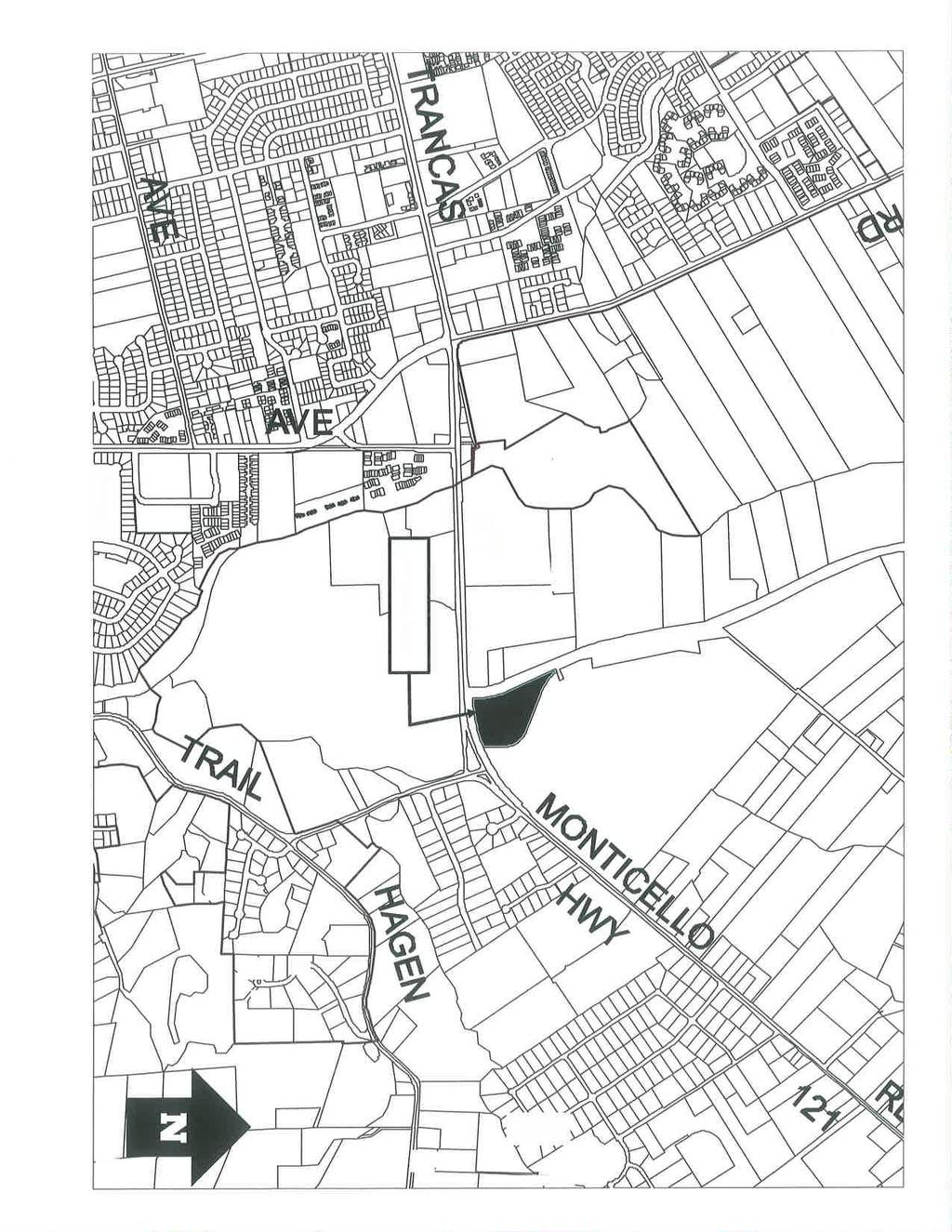
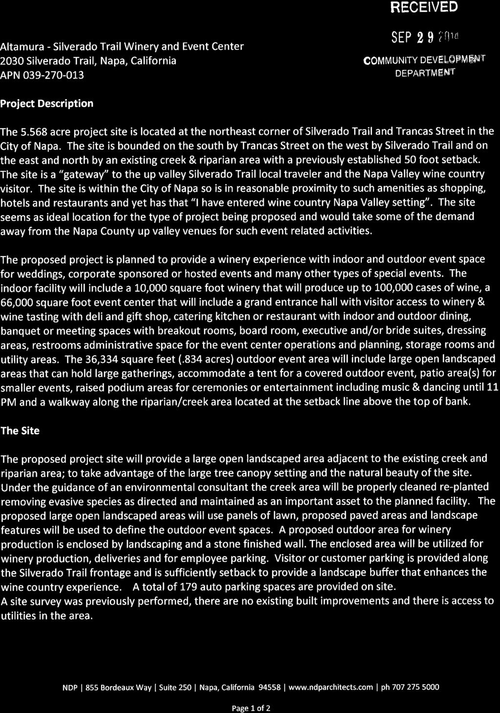
1 Community Development Department Planning Division 1600 First Street + P.O. Box 660 Napa, CA (707) PLANNING COMMISSION STAFFREPORT December 4, 2014 AGENDA ITEM 8.A ; ALTAMURA WINERY / EVENT CENTER PRELIMINARY REVIEW I. GENERAL INFORMATION PROJECT SUMMARY: Preliminary review of the Altamura Wine and Event Center LOCATION OF 2009 Silverado Trail PROPERTY: APN GENERAL PLAN: ZONING: APPLICANT: G-98, Greenbelt AR:FP, Agricultural Resource: Floodplain Overlay Steve Cuddy 855 Bordeaux Way, Suite 250 Napa CA STAFFPLANNER: Scott Klingbeil, Senior Planner Phone: (707) LOCATION MAP N 1
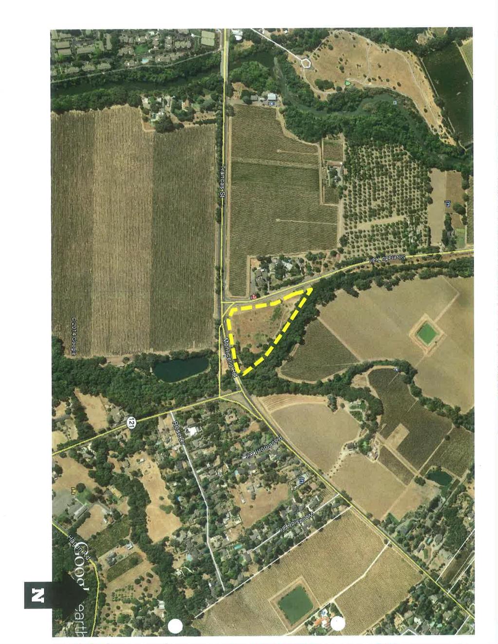
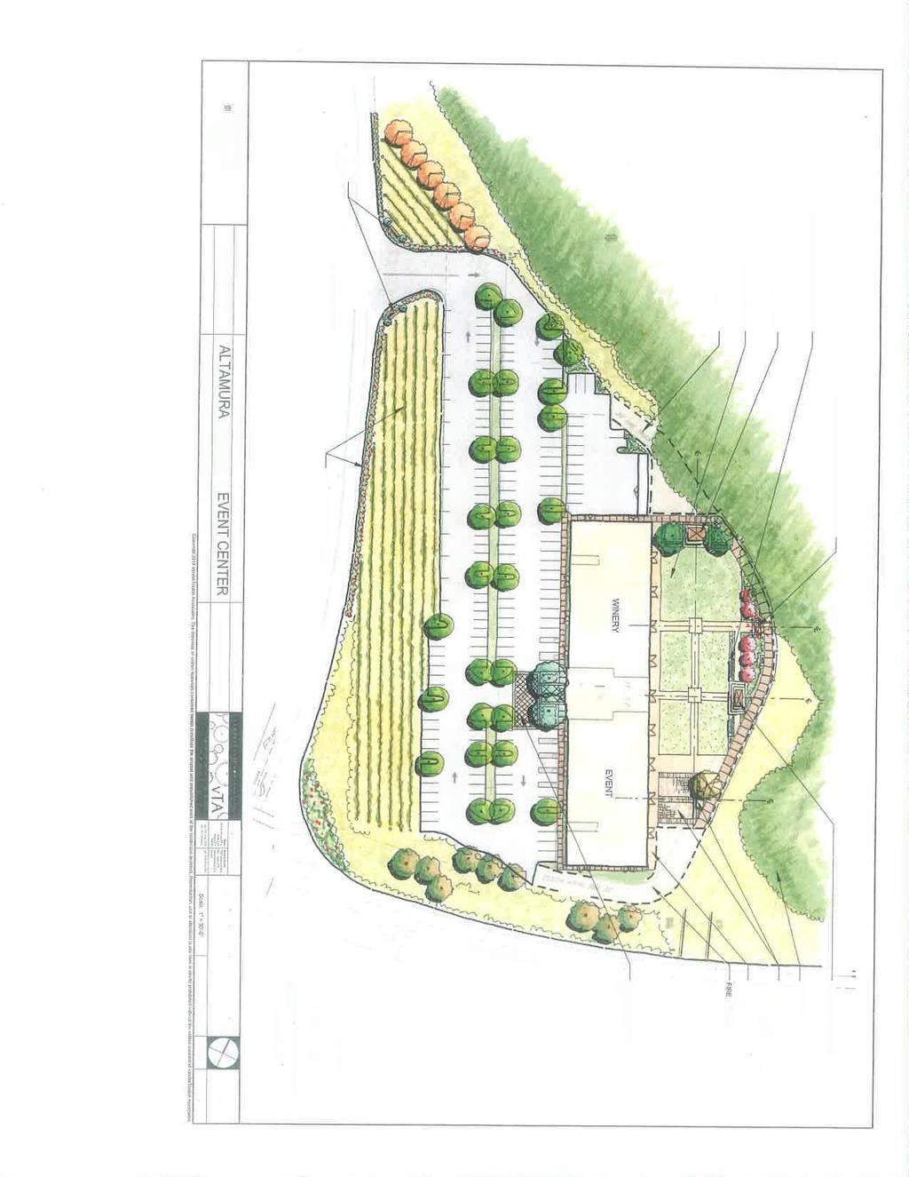
2 II. PURPOSE The purpose of this study session is to provide a preliminary review of the application for the Altamura Winery and Event Center Building located at 2009 Silverado Trail. Preliminary review is a process applied to projects which would benefit from early consultation while an application is being prepared for formal review. This process is increasingly encouraged by the Planning Commission and City Staff for large-scale projects. Comments received during this process are intended to serve as guidance only and should not be considered as preliminary support of or opposition to an application. III. PROJECT DESCRIPTION The applicant is contemplating developing the 5.57 acre property on the northeast corner of the Silverado Trail and Trancas Street intersection with a three story; 77,000 square foot building that will be used as a winery and event center. The proposed winery use would occupy a majority (20,000 square feet) of the first floor with a proposed production of 100,000 cases. The second and third floors would be developed with event spaces and meeting rooms. The proposed events center would include wine tasting, deli, gift shop, restaurant, offices, meeting rooms and event area. The proposed plan also includes extensive outdoor areas for public gathering. A 179 space parking lot is proposed to serve the facility. Vehicle access to the property is proposed with a driveway off the Silverado Trail in the northernmost portion of the property. The proposed building is set back from the street to take advantage of the creekside setting. Site Plan 2
3 The design of the facility provides a larger outdoor event area, several patios and a raised podium area/stage that can accommodate ceremonies and entertainment venues. IV. SETTING AND BACKGROUND The property consists of a vacant parcel of land located at the corner of Silverado Trail and Trancas Street, two roadways that serve as important access routes into and out of the north side of the City. This area is identified as a gateway in the City s General Plan. Although the majority of the site consists of previously graded and disturbed land, a mature and high quality riparian corridor and unnamed stream exist along the north and east border of the site. Vineyards have been developed on the unincorporated lands surrounding the property, with the exception of a veterinary office located immediately across Silverado Trail to the west of the property. The nearest incorporated urban commercial development is located to the west at the intersection of Trancas and Soscol Avenue, and the nearest incorporated residential uses occur to the south along Silverado Trail at the intersection with Hagen Road. Although the site is not contiguous to lands within the City Limit Boundary, it is an incorporated parcel and within the LAFCO-established City of Napa Sphere of Influence and the City of Napa RUL. It is the only property with a Greenbelt General Plan designation that is located within both the city limits and the RUL. The General Plan land use description for Greenbelt indicates that this designation applies to lands outside of the RUL that are to remain in agricultural or very low intensity uses; a footnote in the General Plan indicates that the property at the northeast corner of Silverado Trail and Trancas (the subject site) is an exception, having been an incorporated parcel within the RUL since 1975 with a Greenbelt designation since It should be noted that during the adoption process for the 1998 General Plan, the City recognized the desire of the property owner to modify the land use designation, but elected not to make changes without a specific development plan and accompanying application before the City. The City s General Plan FEIR (certified 12/1/98) considered the possibility for this parcel to be designated TC, Tourist Commercial. After adoption of the General Plan, in response to a request for clarification of RUL status, in February 1999 the City Council confirmed that the property had been within the City s RUL since 1975 and decided to continue the Greenbelt designation. At that time, the Council again deferred consideration of a more urban land use designation until a specific project request was proposed. In May 2003, the City Council denied an application by Mr. Altamura requesting a General Plan Amendment and development application for a 90 room hotel with restaurant, bar and meeting rooms. V. ANALYSIS A. General Plan The property is currently designated Greenbelt by the General Plan which is a designation that generally applies to lands outside of the RUL that are to remain in agricultural or very low intensity uses. A footnote in the General Plan indicates that the property at the northeast corner of Silverado Trail and Trancas is an exception. In order 3
4 to allow the proposed wine center it would be necessary for the applicant to request a General Plan amendment to change the land use designation to TC-Tourist Commercial. The General Plan definition of TC is as follows: TC Tourist Commercial: This designation provides for commercial retail and service uses oriented toward tourists and other visitors to the community. The designation includes destination-resort hotels, motels, and their recreational amenities, such as golf courses, tennis courts, and their related clubs and facilities. This designation also includes community and visitor-serving retail commercial, entertainment, restaurants, service stations, and similar compatible uses. Visitor-serving retail uses which emphasize the historic role of the Napa Valley in viticulture, such as wineries and wine centers, are also permitted. The FAR shall not exceed The proposed project would not be allowed under the existing Greenbelt designation, but would be consistent with the TC, Tourist Commercial land use designation. B. Zoning The property is located within the AR, Agricultural Resource Zoning District, which is applied to lands within the RUL designated Resource Area or Greenbelt by the Napa General Plan. These are sensitive lands within the RUL that require special standards due to viewshed, resource, habitat, geotechnical or other considerations that further the resource protection goals of the General Plan. Primary purposes of the AR District are: 1. To protect sensitive lands within the RUL that are not appropriate for urban development due to viewshed, resource, habitat, geotechnical or other considerations and are intended to remain unchanged or in very low intensity agricultural, private open space or residential use. 2. To retain large, agriculturally viable parcels and conserve the region s economically important agricultural resources. Agricultural related uses such as a winery are listed as a conditional use within the AR District, requiring the approval of a Use Permit. Additionally the AR District allows clubs, lodges and other public/quasi public uses of an administrative, educational, religious, cultural, communications or public service nature as a conditional use. The proposed building complies with the setback and yard requirements of the AR District; however, the proposed three story building at 43 5 exceeds the both the 2.5 stories limitation and the 30 foot height limitation. The proposed building height also exceeds the 40 foot building height limitation of the Tourist Commercial Zoning District in the event a future application includes a rezoning request. As the proposed use includes convention, banquet, restaurant or meeting facilities, the parking ratio shall be determined by Planning Commission, based on parking study provided by applicant and acceptable to the city. The proposed 179 space parking lot appears substandard given the range of assembly uses that may be allowed within the building. 4
5 C. Design The proposed three-story mixed use building will be 342 feet long by 80 feet wide. The building will have cut stone on the exterior of the first two floors and vertical siding on the third story. Wood doors with caststone surrounds and pilasters are proposed. The roof will be a standing metal seam. A tower element up to 54 feet is proposed within the center of the building at the main entrance. D. Flooding The property is subject to Floodplain Management Regulations contained in Chapter of the Municipal Code. These regulations establish standards to protect persons and property from the hazards of development in the floodplain and floodway of the Napa River and its tributaries, and require that a flood plain permit be obtained for all developments on lots zoned :FP. In 2003 the Public Works Department reviewed an application for a building that was similar in size and location. At that time it was determined that the proposed development was feasible as proposed. However, new/additional analysis will be required in order to determine if this application will comply with the :FP Regulations. VI. ENVIRONMENTAL REVIEW This preliminary review is not subject to a formal CEQA determination as the preliminary review does not constitute a project. A future development application would need to include analysis and studies to review several potential impacts that could result from development of the property which include impacts associated with; traffic, hydrologic, archaeological, biologic assessment, jurisdictional determination, wetland delineation, noise and a sewer study. VII. REQUIRED ACTION No formal action is required by the Planning Commission as this study session is for preliminary comments only. Other issues such as environmental impacts, Zoning consistency and Design Review consistency will be addressed in more detail at the time a future application is deemed complete and scheduled for a formal public hearing. VI. DOCUMENTS ATTACHED 1. Location Map & Aerial Photo 2. Applicant s Written Project Description 3. Plan Drawings and Elevations Prepared by: Scott Klingbeil Senior Planner c: Applicant 5
6 6
7 ATTACHMENT 1 7
8 ATTACHMENT 1 8

9 ATTACHMENT 2 9

10 ATTACHMENT 2 10

11 ATTACHMENT 3 11
12 ATTACHMENT 3 12
13 ATTACHMENT 3 13

14 ATTACHMENT 3 14
15 ATTACHMENT 3 15
16 ATTACHMENT 3 16
17 ATTACHMENT 3 17
3.0 LAND USE PLAN. 3.1 Regional Location. 3.2 Existing Conditions Existing Uses. Exhibit Regional Location Map
 3.0 LAND USE PLAN 3.1 Regional Location The Anaheim Resort Specific Plan (ARSP) area is located in the City of Anaheim, which is 35 miles southeast of downtown Los Angeles and 7 miles northwest of Santa
Regulation Changes for Open Space and Similar Uses
 Regulation Changes for Open Space and Similar Uses What is the Project? This project is an analysis of the Zoning Ordinance relating to public lands and open space regulations. The proposed text amendments
2.0 AREA PLANS. Lakeside Business District. Lakeside Business District Land Use Categories:
 Lakeside Business District Lakeside Business District Land Use Categories: Campus Commercial Campus Commercial means a mixture of uses which includes corporate offices, office parks, hotels, commercial,
6. REGIONAL AND COMMUNITY FACILITIES DESIGNATIONS 6.1. OBJECTIVES FOR REGIONAL AND COMMUNITY FACILITIES LAND USE DESIGNATIONS
 6. REGIONAL AND COMMUNITY FACILITIES DESIGNATIONS INTRODUCTION The Regional and land use designations provide the primary locations for uses which satisfy the health, education and other service needs
SONOMA LOCAL AGENCY FORMATION COMMISSION
 For accessibility assistance with any of the following documents, please contact Sonoma LAFCO at (707) 565-2577 or email us at cynthia.olson@sonoma-county.org. SONOMA LOCAL AGENCY FORMATION COMMISSION
ROLL CALL Member Anthony, Member Avdoulos, Member Greco, Member Lynch, Member Maday, Chair Pehrson
 CALL TO ORDER The meeting was called to order at 7:00 PM. PLANNING COMMISSION ACTION SUMMARY CITY OF NOVI Regular Meeting July 11, 2018 7:00 PM Council Chambers Novi Civic Center 45175 W. Ten Mile (248)
Planning Commission Staff Report June 5, 2008
 Owner/Applicant Taylor Village Sacramento Investments Partners, LP c/o Kim Whitney 1792 Tribute Road #270 Sacramento, CA 95815 Staff Recommendation Planning Commission Staff Report Project: File: Request:
Village of Glenview Plan Commission
 Village of Glenview Plan Commission STAFF REPORT January 22, 2019 TO: Chairman and Plan Commissioners CASE #: P2018-047 FROM: Community Development Department CASE MANAGER: Tony Repp, Senior Planner SUBJECT:
3.10 LAND USE SETTING PROJECT SITE EXISTING LAND USE DESIGNATIONS AND ZONING. General Plan Land Use Designations.
 This section of the Draft EIR addresses the existing land uses on and adjacent to the project site and discusses the potential impacts of the proposed project on existing land uses. Key issues addressed
D1 September 11, 2013 Public Hearing APPLICANT:
 D1 September 11, 2013 Public Hearing APPLICANT: BEACH MUNICIPAL FEDERAL CREDIT UNION PROPERTY OWNER: SISTERS II, LLC STAFF PLANNER: Karen Prochilo REQUEST: Conditional Change of Zoning (AG-2 Agriculture
PLANNING COMMISSION AGENDA REPORT APRIL 7, 2016
 PLANNING COMMISSION AGENDA REPORT APRIL 7, 2016 TO: FROM: Members of the Planning Commission Talyn Mirzakhanian, Senior Planner FILE NO.: 160001710 PROPOSAL: APPLICANT: RECOMMENDATION: A request for a
PROJECTS AND THE PUBLIC ART MASTER PLAN
 MEMO TO: PUBLIC ART STEERING COMMITTEE MEMBERS FROM: SHARI COOPER, DEVELOPMENT PROJECT COORDINATOR DATE: FEBRUARY 24, 2017 SUBJECT: AGENDA ITEM 5.A: PUBLIC ART PROJECT FOR 2017-18 BACKGROUND One of the
Staff Report to the North Ogden City Planning Commission
 Staff Report to the North Ogden City Planning Commission SYNOPSIS / APPLICATION INFORMATION Application Request: Concept review on a legislative application to rezone land located at approximately 1750
- INVITATION - COURTESY INFORMATIONAL MEETING
 - INVITATION - COURTESY INFORMATIONAL MEETING Hosted by the Property Owner and Project Developer CAMELLIA COURT DEVELOPMENT WEDNESDAY, JANUARY 25, 2017, 7:00 9:00 P.M. BLOY CENTER 1441 S. BENITO AVE, ALHAMBRA,
MIXED-USE VILLAGE OVERLAY FLOATING DISTRICT
 MIXED-USE VILLAGE OVERLAY FLOATING DISTRICT Zoning regulations developed by committee to the Planning Board for the Town of DeWitt, NY Issue date: 13 July 2017 revised 3/12/2018, revised 4/26/2018, 5/9/2018
The transportation system in a community is an
 7 TRANSPORTATION The transportation system in a community is an important factor contributing to the quality of life of the residents. Without a sound transportation system to bring both goods and patrons
4 LAND USE DESIGNATIONS
 4 LAND USE DESIGNATIONS Chapter 4 describes the land use designations and densities that will implement the development vision for North Burlingame outlined in Chapter 3. Land use densities are described
Mark-up of the effect of the proposed Bronte Village Growth Area OPA No.18 on the text of section 24, Bronte Village, of the Livable Oakville Plan
 Mark-up of the effect of the proposed Bronte Village Growth Area OPA No.18 on the text of section 24, Bronte Village, of the Livable Oakville Plan Notes: This document is provided for information purposes
PC RESOLUTION NO ARCHITECTURAL CONTROL (AC)
") PC RESOLUTION NO. 16-07-26- ARCHITECTURAL CONTROL (AC) 15-035 A RESOLUTION OF THE PLANNING COMMISSION OF THE CITY OF SAN JUAN CAPISTRANO, CALIFORNIA APPROVING ARCHITECTURAL CONTROL (AC) 15-035, INN AT
PC RESOLUTION NO. 16-07-26- ARCHITECTURAL CONTROL (AC) 15-035 A RESOLUTION OF THE PLANNING COMMISSION OF THE CITY OF SAN JUAN CAPISTRANO, CALIFORNIA APPROVING ARCHITECTURAL CONTROL (AC) 15-035, INN AT
COUNTY COUNCIL OF PRINCE GEORGE'S COUNTY, MARYLAND SITTING AS THE DISTRICT COUNCIL 2010 Legislative Session. Council Members Dernoga and Olson
 DR- COUNTY COUNCIL OF PRINCE GEORGE'S COUNTY, MARYLAND SITTING AS THE DISTRICT COUNCIL 00 Legislative Session Bill No. CB--00 Chapter No. Proposed and Presented by Introduced by Co-Sponsors The Chairman
6 PORT SYDNEY SETTLEMENT AREA
 Section 6 Port Sydney Page 61 6 PORT SYDNEY SETTLEMENT AREA 6.1 Basis and Principles Village of Port Sydney Waterfront Community Existing Services 6.1.1 Port Sydney is an historic settlement that has developed
SUBJECT: PREDEVELOPMENT PLAN REVIEW OF PROJECT LOCATED AT E. COLORADO BOULEVARD (PASEO COLORADO)
") TO: FROM: Honorable Mayor and City Council Planning & Community Development Department SUBJECT: PREDEVELOPMENT PLAN REVIEW OF PROJECT LOCATED AT 260-400 E. COLORADO BOULEVARD (PASEO COLORADO) RECOMMENDATION:
TO: FROM: Honorable Mayor and City Council Planning & Community Development Department SUBJECT: PREDEVELOPMENT PLAN REVIEW OF PROJECT LOCATED AT 260-400 E. COLORADO BOULEVARD (PASEO COLORADO) RECOMMENDATION:
City of Lafayette Study Session Staff Report Design Review Commission
 City of Lafayette Study Session Staff Report Design Review Commission Meeting Date: April 24, 2017 Staff: Payal Bhagat, Senior Planner Subject: HDP18-15 & HDP31-15 Ramesh Patel & Melcor Development (Owners),
UNIVERSITY OF MICHIGAN:
 Chapter Eight UNIVERSITY OF MICHIGAN: North Campus I. Introduction The University of Michigan currently owns approximately 800 acres of land in the northeast section of Ann Arbor. North Campus refers to
4 C OMMUNITY D ISTRICTS
 4 C OMMUNITY D ISTRICTS N ew development in the Area will include many different types of land uses, including a destination retail area that attracts people from all over the region; recreation opportunities
The Maryland-National Capital Park and Planning Commission Prince George's County Planning Department Development Review Division
 The Maryland-National Capital Park and Planning Commission Prince George's County Planning Department Development Review Division 301-952-3530 Note: Staff reports can be accessed at www.mncppc.org/pgco/planning/plan.htm.
VILLAGE OF CLEMMONS PLANNING BOARD DRAFT STAFF REPORT
 VILLAGE OF CLEMMONS PLANNING BOARD DRAFT STAFF REPORT PETITION INFORMATION Docket # C-226 Staff Megan Ledbetter Petitioner(s) JBJH Properties, LLC Owner(s) JBJH Properties, LLC Subject Property 5892-49-1766
M E M O R A N D U M SITE DATA
 Department of Community Planning & Economic Development 250 South 4 th Street, Room 300 Minneapolis, MN 55415-1385 M E M O R A N D U M TO: City Planning Commission, Committee of the Whole FROM: Lisa Steiner,
SUBJECT: PREDEVELOPMENT PLAN REVIEW OF PROJECT LOCATED AT 2632 EAST WASHINGTON BOULEVARD ('ST. LUKE MEDICAL CENTER')
") TO: FROM: Honorable Mayor and City Council Planning & Community Development Department SUBJECT: PREDEVELOPMENT PLAN REVIEW OF PROJECT LOCATED AT 2632 EAST WASHINGTON BOULEVARD ('ST. LUKE MEDICAL CENTER')
TO: FROM: Honorable Mayor and City Council Planning & Community Development Department SUBJECT: PREDEVELOPMENT PLAN REVIEW OF PROJECT LOCATED AT 2632 EAST WASHINGTON BOULEVARD ('ST. LUKE MEDICAL CENTER')
City of Lafayette Study Session Staff Report Design Review Commission
 ++ City of Lafayette Study Session Staff Report Design Review Commission Meeting Date: January 08, 2018 Staff: Subject: Chris Juram, Planning Technician SS12-17 Miramar Homebuilders, R-20 Zoning: Request
Staff Planner Jimmy McNamara. Location 2641 Princess Anne Road GPIN Site Size 10.8 acres AICUZ Less than 65 db DNL
 Applicant & Property Owner Public Hearing July 13, 2016 City Council Election District Princess Anne Agenda Item 4 Request Modification of Conditions (Conditional Use Permit approved by City Council on
REPORT TO PLANNING AND DESIGN COMMISSION City of Sacramento
 REPORT TO PLANNING AND DESIGN COMMISSION City of Sacramento 5 PUBLIC HEARING June 12, 2014 To: Members of the Planning and Design Commission Subject: Newman Center Sign (P14-017) A request to construct
Notice of Preparation of an Environmental Impact Report and Scoping Meeting for the Canyon Lane Roadway Improvements Development Project
 of an Environmental Impact Report and Scoping Meeting for the As the Lead Agency, the County of San Mateo (County) will prepare an Environmental Impact Report (EIR) for the (project), and would like your
7437, 7439 and 7441 Kingston Road - Zoning By-law Amendment and Site Plan Control Applications - Preliminary Report
 STAFF REPORT ACTION REQUIRED 7437, 7439 and 7441 Kingston Road - Zoning By-law Amendment and Site Plan Control Applications - Preliminary Report Date: August 13, 2015 To: From: Wards: Reference Number:
CITY OF PUYALLUP. Background. Development Services
 CITY OF PUYALLUP Development Services 333 South Meridian Puyallup WA 98371 To: City Council From: Katie Baker, AICP, Planning Division Re: South Hill Neighborhood Plan Adoption Date: (Meeting date: February
NOTICE OF PREPARATION
 NOTICE OF PREPARATION DATE: January 6, 2016 TO: LEAD AGENCY: Responsible Agencies, Organizations, and Interested Parties Contact: Tyler Barrington, Principal Planner Planning Department Community Development
Rezoning Petition Final Staff Analysis June 18, 2018
 Rezoning Petition 2018-028 Final Staff Analysis June 18, 2018 REQUEST Current Zoning: MX-1 LLWPA (mixed use district, Lower Lake Wylie Protected Area), R-3 LLWPA (single family residential, Lower Lake
Request Alternative Compliance to the prescribed criteria of the Oceanfront Resort District Form-Based Code. Staff Recommendation Approval
 Applicant & Property Owner Public Hearing February 8, 2017 City Council Election District Beach Agenda Item D1 Request Alternative Compliance to the prescribed criteria of the Oceanfront Resort District
STAFF REPORT DEVELOPMENT COMMISSION ZONING MEETING CITY OF COLUMBUS, OHIO JANUARY 10, 2019
 STAFF REPORT DEVELOPMENT COMMISSION ZONING MEETING CITY OF COLUMBUS, OHIO JANUARY 10, 2019 5. APPLICATION: Z18-063 Location: 4053 WEST BROAD STREET (43228), being 6.42± acres located at the southeast corner
Request Alternative Compliance to the prescribed criteria of the Oceanfront Resort District Form- Based Code. Staff Recommendation Approval
 Applicant Property Owner Steven H. Murden Public Hearing June 14, 2017 City Council Election District Beach Agenda Item 8 Request Alternative Compliance to the prescribed criteria of the Oceanfront Resort
STAFF REPORT NATIONAL MEDAL OF HONOR MUSEUM
 STAFF REPORT NATIONAL MEDAL OF HONOR MUSEUM For reference, the Zoning Code and Land Development Regulations are available online. AGENDA ITEM: 5.b. Case #: Request: Location: Type of Request: Public Hearing:
LOS ANGELES CITY PLANNING DEPARTMENT STAFF REPORT
 LOS ANGELES CITY PLANNING DEPARTMENT STAFF REPORT LOS ANGELES CITY PLANNING COMMISSION CASE NO: CPC 2006-9374 CRA CEQA: Exempt DATE: December 21, 2006 Location: Valley Plaza and Laurel Plaza TIME: after
AWH REPORT OF THE PLANNING AND DEVELOPMENT DEPARTMENT FOR APPLICATION FOR REZONING ORDINANCE TO PLANNED UNIT DEVELOPMENT
 AWH REPORT OF THE PLANNING AND DEVELOPMENT DEPARTMENT FOR APPLICATION FOR REZONING ORDINANCE TO PLANNED UNIT DEVELOPMENT MAY 8, 2014 The Planning and Development Department hereby forwards to the Planning
PINE CURVE REZONING. Property does not meet criteria for open space preservation and is not a candidate for a park
 PINE CURVE REZONING BACKGROUND Purchased as two parcels in 2001 and 2002 Annexed and Zoned Greater Downtown District Historic Center September 25, 2002 and October 7, 2002 WHAT THE PROJECT IS AND IS NOT
12 January 12, 2011 Public Hearing APPLICANT: TAILWIND DEVELOPMENT GROUP,LLC PROPERTY OWNER: CITY OF VIRGINIA BEACH
 12 January 12, 2011 Public Hearing APPLICANT: TAILWIND DEVELOPMENT GROUP,LLC PROPERTY OWNER: CITY OF VIRGINIA BEACH STAFF PLANNER: Faith Christie REQUEST: Conditional Change of Zoning (from PD-H1 Planned
STAFF REPORT INTRODUCTION
 STAFF REPORT SUBJECT: DATE: Application for Master Land Use Plan Modification Southern Village Master Land Use Plan (Project No. 12-101) May 22, 2013 (Community Design Commission) May 23, 2013 (Transportation
Request Conditional Rezoning (R-10 Residential & I-1 Light Industrial to Conditional I-1 Light Industrial) Staff Recommendation Approval
 Staff Recommendation Approval") Applicant & Property Owner Public Hearing January 9, 2019 City Council Election District Beach Agenda Item 1 Request Conditional Rezoning (R-10 Residential & I-1 Light Industrial to Conditional I-1 Light
Applicant & Property Owner Public Hearing January 9, 2019 City Council Election District Beach Agenda Item 1 Request Conditional Rezoning (R-10 Residential & I-1 Light Industrial to Conditional I-1 Light
STAFF REPORT FOR STANDARD COASTAL DEVELOPMENT PERMIT #CDP FEBRUARY 26, 2015 CPA - 1 PO BOX 238 APTOS, CA 94001
 STAFF REPORT FOR STANDARD COASTAL DEVELOPMENT PERMIT #CDP 2014-0030 FEBRUARY 26, 2015 CPA - 1 OWNER/APPLICANT: AGENT: REQUEST: HANS HEIM PO BOX 238 APTOS, CA 94001 JAMES HAY PO BOX 762 MENDOCINO, CA 95460
LAND USE AMENDMENT DOWNTOWN COMMERCIAL CORE (WARD 7) MACLEOD TRAIL SE AND 5 AVENUE SE BYLAW 254D2017
 MACLEOD TRAIL SE AND 5 AVENUE SE BYLAW 254D2017") Page 1 of 10 EXECUTIVE SUMMARY This Land Use Amendment application seeks to redesignate a full downtown block (currently the YWCA site) from a Direct Control based on the CM-2 District (Land Use Bylaw
Page 1 of 10 EXECUTIVE SUMMARY This Land Use Amendment application seeks to redesignate a full downtown block (currently the YWCA site) from a Direct Control based on the CM-2 District (Land Use Bylaw
Request Modification of Proffers Approved by City Council on May 8, 2012 Modification of Conditions (Mini- Warehouse) Staff Recommendation Approval
 Staff Recommendation Approval") Applicant & Property Owner Salem Lakes Storage, LLC, a VA Limited Liability Company Public Hearing February 8, 2017 City Council Election District Centerville Agenda Item 4 Request Modification of Proffers
Applicant & Property Owner Salem Lakes Storage, LLC, a VA Limited Liability Company Public Hearing February 8, 2017 City Council Election District Centerville Agenda Item 4 Request Modification of Proffers
OFFICE CONSOLIDATION SECONDARY PLAN AREA 22 THE BRAMALEA SOUTH INDUSTRIAL SECONDARY PLAN
 OFFICE CONSOLIDATION SECONDARY PLAN AREA 22 THE BRAMALEA SOUTH INDUSTRIAL SECONDARY PLAN November 2010 EXPLANATORY NOTES (Secondary Plan Area 22) General (pertaining to all secondary plan office consolidations)
Christopher M. Price, AICP Director of Planning February 7, 2014 STAFF REPORT
 COUNTY OF PRINCE WILLIAM 5 County Complex Court, Prince William, Virginia 22192-9201 PLANNING MAIN (703) 792-7615 FAX (703) 792-4758 OFFICE www.pwcgov.org/planning Christopher M. Price, AICP Director of
O Dell Parkway PUD Association, Inc. PO Box 1335
 CITY OF SOUTH BURLINGTON DEVELOPMENT REVIEW BOARD SD_14_06_F+MDevelopment_25BaconSt_sketch SKETCH PLAN REVIEW #SD-14-06 O DELL PARKWAY PUD DEPARTMENT OF PLANNING & ZONING Report preparation date: April
Request Alternative Compliance to the prescribed criteria of the Oceanfront Resort District Form-Based Code. Staff Planner Kristine Gay
 Applicant/Owner Ocean Rental Properties, LLC Public Hearing April 13, 2016 City Council Election District Beach Agenda Item 1 Request Alternative Compliance to the prescribed criteria of the Oceanfront
ORDINANCE WHEREAS, this Ordinance is consistent with the City of Winter Garden Comprehensive Plan; and
 ORDINANCE 17-06 AN ORDINANCE OF THE CITY COMMISSION OF THE CITY OF WINTER GARDEN, FLORIDA, CREATING ARTICLE XIV OF CHAPTER 118 OF THE CITY OF WINTER GARDEN CODE OF ORDINANCES PROVIDING FOR THE EAST PLANT
CHAPTER 4 - LAND USE CLASSIFICATIONS
 CHAPTER 4 - LAND USE CLASSIFICATIONS Four new land use classification categories are established in the Gualala Town Plan: Gualala Village Mixed Use; Gualala Highway Mixed Use; Gualala Planned Development
Brampton. Secondary Plan. Review. Bram West. A New Direction in Planning & Public Consultation
 Brampton Bram West Secondary Plan Review A New Direction in Planning & Public Consultation Introduction The Bram West Secondary Plan Review offers an important opportunity for the community to define a
City Of Sparks Planning Commission Item
 Page 1 of 12 City Of Sparks Planning Commission Item Meeting Date: May17, 2012 Subject: PCN12009, Public Hearing, Consideration and possible action on a Master Plan Amendment and Rezoning request to change
Planning Districts INTRODUCTION
 INTRODUCTION To facilitate detailed examination of development prospects for all areas of the community, Delano has been divided into 14 planning districts. The location of these planning districts is
Chesapeake Bay Critical Area Conservation Plan
 The Maryland-National Capital Park and Planning Commission Prince George s County Planning Department Development Review Division 301-952-3530 Note: Staff reports can be accessed at www.mncppc.org/pgco/planning/plan.htm.
CHAPTER SPECIAL PURPOSE AND OVERLAY ZONING DISTRICTS
 Special Purpose and Overlay Zoning Districts 106.28.010 CHAPTER 106.28 - SPECIAL PURPOSE AND OVERLAY ZONING DISTRICTS SPECIAL PURPOSE AND OVERLAY ZONING DISTRICTS Sections: 106.28.010 - Purpose 106.28.020
Rezoning Petition Final Staff Analysis May 21, 2018
 Rezoning Petition 2018-010 Final Staff Analysis May 21, 2018 REQUEST Current Zoning: I-2 (general industrial) Proposed Zoning: TOD-M (transit oriented development, mixed-use) LOCATION Approximately 0.25
ITEM # _ 41 _ DATE: COUNCIL ACTION FORM MAJOR FINAL PLAT FOR MENARDS SUBDIVISION BACKGROUND:
 ITEM # _ 41 _ DATE: 06-12-18 COUNCIL ACTION FORM SUBJECT: MAJOR FINAL PLAT FOR MENARDS SUBDIVISION BACKGROUND: The City s subdivision regulations are included in Chapter 23 of the Ames Municipal Code.
GENERAL PLAN UPDATE ISSUES MEETING. January 21, 2010 City Hall Mitchell Room 6:00 pm 9:00 pm
 GENERAL PLAN UPDATE ISSUES MEETING January 21, 2010 City Hall Mitchell Room 6:00 pm 9:00 pm WELCOME! Introductory Comments Continued Review of Quality of Life Standards, Growth Management, Proposition
MEMORANDUM. DATE: March 15, Chairman and Members Community Redevelopment Agency. Leif J. Ahnell, C.P.A., C.G.F.O. Executive Director
 MEMORANDUM DATE: March 15, 2019 TO: FROM: Chairman and Members Community Redevelopment Agency Leif J. Ahnell, C.P.A., C.G.F.O. Executive Director SUBJECT: Camino Square, IDA No. CRP-16-02, located at 171
TABLE OF CONTENTS 1.0 INTRODUCTION... 3
 TABLE OF CONTENTS 1.0 INTRODUCTION... 3 1.1. BACKGROUND... 3 1.2. THE PROPOSAL... 5 2.0 EXISTING POLICY FRAMEWORK... 5 2.1. PROVINCIAL POLICY STATEMENT (PPS)... 5 2.2. CITY OF LONDON OFFICIAL PLAN (OP)...
Gold Line Bus Rapid Transit Transit Oriented Development (BRTOD) Helmo Station Area Plan
 Helmo Station Area Plan") Appendix F Gold Line Bus Rapid Transit Transit Oriented Development (BRTOD) Helmo Station Area Plan Introduction and Purpose of the Plan The Gold Line Bus Rapid Transit facility is an eleven-mile dedicated
Appendix F Gold Line Bus Rapid Transit Transit Oriented Development (BRTOD) Helmo Station Area Plan Introduction and Purpose of the Plan The Gold Line Bus Rapid Transit facility is an eleven-mile dedicated
Metro. Activity Center Design Guidelines. Recommendations For Developing Focused, Mixed-Use Commercial/Residential Centers
 Metro Activity Center Design Guidelines Recommendations For Developing Focused, Mixed-Use Commercial/Residential Centers Metro Activity Centers What is a MAC? Legacy, the adopted guide for the future growth
Report to City Council
 Attachment 4 BUDGET OFFICER CITY ATTORNEY APPROVALS CITY MANAGER Report to City Council TO: FROM: Mayor and City Council John C. Terell, Community and Economic Development Director AGENDA DATE: June 24,
City of Lafayette Staff Report
 City of Lafayette Staff Report For: By: Design Review Commission Greg Wolff, Senior Planner Meeting Date: April 27, 2015 Subject: SS03-15 Gundi & Peter Younger (Owners), R-40 Zoning: Request for a Study
PC RESOLUTION NO GRADING PLAN MODIFICATION (GPM)
") PC RESOLUTION NO. 16-07-26- GRADING PLAN MODIFICATION (GPM) 16-006 A RESOLUTION OF THE PLANNING COMMISSION OF THE CITY OF SAN JUAN CAPISTRANO, CALIFORNIA APPROVING GRADING PLAN MODIFICATION (GPM) 16-006,
PC RESOLUTION NO. 16-07-26- GRADING PLAN MODIFICATION (GPM) 16-006 A RESOLUTION OF THE PLANNING COMMISSION OF THE CITY OF SAN JUAN CAPISTRANO, CALIFORNIA APPROVING GRADING PLAN MODIFICATION (GPM) 16-006,
5 May 9, 2012 Public Hearing APPLICANT: MICHAEL H. NORMENT
 5 May 9, 2012 Public Hearing APPLICANT: MICHAEL H. NORMENT PROPERTY OWNER: JOAN DALIS REQUEST: Conditional Use Permit (Commercial Parking Lot) STAFF PLANNER: Faith Christie ADDRESS / DESCRIPTION: 3233
Narcoossee Roadway Corridor
 Community Meeting Narcoossee Roadway Corridor April 5, 2012 Meeting Agenda Purpose of Meeting Continuation of Study Update Process (Previous Meetings Oct. & Nov., 2011) Tonight s Objective Review Proposals
4780 Eglinton Avenue West - Zoning By-law Amendment and Draft Plan of Subdivision Applications - Preliminary Report
 STAFF REPORT ACTION REQUIRED 4780 Eglinton Avenue West - Zoning By-law Amendment and Draft Plan of Subdivision Applications - Preliminary Report Date: May 29, 2014 To: From: Wards: Reference Number: Etobicoke
240 and 242 Finch Avenue West Zoning By-law Amendment Application Preliminary Report
 REPORT FOR ACTION 240 and 242 Finch Avenue West Zoning By-law Amendment Application Preliminary Report Date: March 1, 2019 To: North York Community Council From: Director, Community Planning, North York
Rezoning Petition Pre-Hearing Staff Analysis May 21, 2018
 Rezoning Petition 2018-028 Pre-Hearing Staff Analysis May 21, 2018 REQUEST Current Zoning: MX-1 LLWPA (mixed use district, Lower Lake Wylie Protected Area), R-3 LLWPA (single family residential, Lower
(DC1) Direct Development Control Provision DC1 Area 4
 Direct Development Control Provision DC1 Area 4") . General Purpose (DC) Direct Development Control Provision DC Area 4 The purpose of this Provision is to provide for an area of commercial office employment and residential development in support of the
. General Purpose (DC) Direct Development Control Provision DC Area 4 The purpose of this Provision is to provide for an area of commercial office employment and residential development in support of the
D E S I G N R E V I E W B OA R D
 Agenda Report City of Great Falls D E S I G N R E V I E W B OA R D February 28, 2011 C O N T R A C T F L O O R I N G N EW B U I L D I N G Case Number DRB2011-2 Applicant Steve L Heureux (LPW Architects)
Town of Portola Valley General Plan. Nathhorst Triangle Area Plan
 Town of Portola Valley General Plan Amended December 10, 1997 Table of Contents Introduction... 1 Planning Area... 1 Objectives... 2 Principles... 2 Standards... 4 Description... 4 Community Commercial...
A. WHAT IS A GENERAL PLAN?
 I. Introduction A. WHAT IS A GENERAL PLAN? A general plan is the planning guideline for the future of a city. It contains goals and policies which regulate urban development, the protection of the natural
Chapter 5: Natural Resources and Environment
 NATURAL RESOURCES AND ENVIRONMENT 5-1 5 Chapter 5: Natural Resources and Environment BACKGROUND AND INTENT Urban expansion represents the greatest risk for the future degradation of existing natural areas,
LIST OF TABLES, FIGURES AND APPENDICES
 LIST OF TABLES, FIGURES AND APPENDICES Chapter Page 2 INTERPRETATION FIGURE 2.1 SAMPLE AWNING...2.8 FIGURE 2.2 SAMPLE LOW-RISE APARTMENT DESIGN...2.9 FIGURE 2.3 SAMPLE DUPLEX DESIGN...2.10 FIGURE 2.4 SAMPLE
CITY OF LOMPOC PLANNING COMMISSION STAFF REPORT
 CITY OF LOMPOC PLANNING COMMISSION STAFF REPORT DATE: January 11, 2017 TO: FROM: Members of the Planning Commission Sara Farrell, Assistant Planner RE: Development Plan Review DR 16-05 The Laundry Room
LUNDY S LANE COMMUNITY IMPROVEMENT PLAN STUDY
 PUBLIC INFORMATION MEETING #2 October 12, 2016 LUNDY S LANE COMMUNITY IMPROVEMENT PLAN STUDY AGENDA 5:00 to 5:30pm: Open House 5:30 to 6:15pm: Presentation 6:15 to 7:00pm: Individual paced workshop with
Downtown / Ballough Road Redevelopment Board
 Agenda Item 5 CONDITIONAL USE DEV2014-095 Pai in the Sky Downtown / Ballough Road Redevelopment Board Staff Report TO: Downtown / Ballough Road Board Members FROM: Jason Jeffries, Project Manager DATE:
Colerain Township report to. Hamilton County Regional Planning Commission. December 2, 2010, 1:00PM. t a f f r e p o r t
 Colerain Township report to Hamilton County Regional Planning Commission December 2, 2010, 1:00PM Preliminary Plan: Case No.: ZA2001-04, Forevergreen Prepared By: Amy Bancroft, Land Use Planner t a f f
-MENDOCINO COUNTY PLANNING AND BUILDING SERVICES- DIVISION II OF TITLE 20--COASTAL ZONING CODE
 CHAPTER 20.504 VISUAL RESOURCE AND SPECIAL TREATMENT AREAS Sec. 20.504.005 Applicability. Sec. 20.504.010 Purpose. Sec. 20.504.015 Highly Scenic Areas. Sec. 20.504.020 Special Communities and Neighborhoods.
SUBDIVISION, PLANNED UNIT DEVELOPMENT, PLANNING APPROVAL, REZONING & SIDEWALK WAIVER STAFF REPORT Date: February 7, 2013
 SUBDIVISION, PLANNED UNIT DEVELOPMENT, PLANNING APPROVAL, REZONING & SIDEWALK WAIVER STAFF REPORT Date: February 7, 2013 APPLICANT NAME SUBDIVISION NAME DEVELOPMENT NAME LOCATION S. E. Cemeteries of AL
Request for Decision. Recommendation. Presented: Monday, Jul 07, Report Date Friday, Jun 20, Type: Public Hearings
 Presented To: Planning Committee Request for Decision Application for rezoning in order to permit a place of worship on a vacant lot zoned for C1, Local Commercial uses, Cam Street, Sudbury Sitiri Investments
I. STAFF POLICY RECOMMENDATIONS. The following RMP policy strategies are proposed by staff in support of a Scenic Resource Protection Program:
 Policy Consideration: Scenic Resource Protection Program Status: For Consideration by the Highlands Council at September 14, 2006 Work session Date: September 12, 2006 I. STAFF POLICY RECOMMENDATIONS The
Be it enacted by the Town Board of the Town of Guilderland that the following new A (Transit Oriented Development (TOD) District) is adopted:
 District) is adopted:") Local Law No. 4 of 2018 (Adoption of 280-18A (Transit Oriented Development District) Be it enacted by the Town Board of the Town of Guilderland that the following new 280-18A (Transit Oriented Development
Local Law No. 4 of 2018 (Adoption of 280-18A (Transit Oriented Development District) Be it enacted by the Town Board of the Town of Guilderland that the following new 280-18A (Transit Oriented Development
STAFF REPORT. December 20, North York Community Council. Director, Community Planning, North York District
 STAFF REPORT December 20, 2005 To: From: Subject: North York Community Council Director, Community Planning, North York District Preliminary Report Application to Amend the Official Plan and Zoning By-law
Public Meeting March 10 th 2011
 Public Meeting March 10 th 2011 Agenda 6:00-6:15 6:15-7:00 7:00-8:00 8:00-8:30 8:30-9:00 9:00 Welcome and Introductions Presentation» Project Overview» Recap Existing Conditions / Issues & Opportunities»
CAO Update Status Work continues on products: Draft ordinance BAS report CAO process summary (2002 to present) Comprehensive e Plan policy review Some
 Comprehensive e Plan policy review Some") Critical Areas Ordinance Update Wetlands Andrew Deffobis Jeremy Davis Cynthia Wilson Thurston County Planning April 6, 2011 CAO Update Status Work continues on products: Draft ordinance BAS report CAO
Critical Areas Ordinance Update Wetlands Andrew Deffobis Jeremy Davis Cynthia Wilson Thurston County Planning April 6, 2011 CAO Update Status Work continues on products: Draft ordinance BAS report CAO
Institutional Master Plan The Arnold Arboretum of Harvard University
 Institutional Master Plan The Arnold Arboretum of Harvard University Submitted to: Boston Redevelopment Authority One City Hall Square Boston, MA 02201 Submitted by: The Arnold Arboretum of Harvard University
KANATA CENTRUM 255 KANATA AVENUE OFFICIAL PLAN AMENDMENT ZONING BY-LAW AMENDMENT
 KANATA CENTRUM 255 KANATA AVENUE OFFICIAL PLAN AMENDMENT ZONING BY-LAW AMENDMENT JUNE 2015 PREPARED BY: FOTENN Consultants Inc. 223 Mcleod Street Ottawa, ON K2P OZ8 (613) 730-5709 PREPARED FOR: Kanata
F. The following uses in the HR District: attached single-family dwellings, condominiums, and institutional uses; and
 1102 DESIGN REVIEW 1102.01 PURPOSE AND APPLICABILITY Section 1102 is adopted to provide standards, criteria, and procedures under which design review may be approved. Design review is required for: A.
PLANNED DEVELOPMENT (MASTER PLAN & UNIT PLAN)
") Central Permit Center 555 Santa Clara Street Vallejo CA 94590 Business License Building Fire Prevention Planning Public Works 707.648.4310 707.648.4374 707.648.4565 707.648.4326 707.651.7151 PLANNED DEVELOPMENT
Central Permit Center 555 Santa Clara Street Vallejo CA 94590 Business License Building Fire Prevention Planning Public Works 707.648.4310 707.648.4374 707.648.4565 707.648.4326 707.651.7151 PLANNED DEVELOPMENT
PLANNED UNIT DEVELOPMENT Date: May 4, 2017
 PLANNED UNIT DEVELOPMENT Date: May 4, 2017 DEVELOPMENT NAME LOCATION Sarah & Michael Stashak 2165 & 2167 Old Shell Road (South side of Old Shell Road, at the Southern terminus of Frazier Court) CITY COUNCIL
14 October 10, 2012 Public Hearing APPLICANT: MPB, INC
 14 October 10, 2012 Public Hearing APPLICANT: MPB, INC PROPERTY OWNER: MUNDEN & ASSOCIATES, LP STAFF PLANNER: Karen Prochilo REQUEST: Conditional Change of Zoning (AG-1 & AG-2 to Conditional O-2) ADDRESS