THE POLICY FRAMEWORK FOR WALKABLE COMMUNITIES. Community Technical Assistance Program Building Active Communities Institute March 2016
|
|
|
- Mavis Mitchell
- 5 years ago
- Views:
Transcription
1 THE POLICY FRAMEWORK FOR WALKABLE COMMUNITIES Community Technical Assistance Program Building Active Communities Institute March 2016
2 ACTIVE COMMUNITIES BACK THEN

3 ACTIVE COMMUNITIES BACK THEN Lifestyle Economic conditions Lack of infrastructure Necessity Smaller footprint
4 ACTIVE COMMUNITIES NOW
5 ACTIVE COMMUNITIES NOW Expanded geography Individual choice Cost/O & M Development patterns Policy & regulation
6 POLICY FRAMEWORK Growth Policy Community Planning & Policy Foundation Other Long Range Plans (Downtown Master Plan, CEDS, Housing Plan, Transportation Plan) Subdivision Regulations New Development and Community Expansion Zoning Regulations New Construction and Community Redevelopment Design Standards Infrastructure, layout & connectivity Design Standards Structure, dimensions and site design
7 OPPORTUNITIES IN GROWTH POLICIES Prioritize walkability, active environments within broad vision/goals infill, connectivity Support design decisions in the update or development of regulations Engage community stakeholders in policy development Incorporate goals & objectives from other long range plans


8 OTHER LONG-RANGE PLANS May include Active Transportation/LRT Plans, Housing Plans, Downtown Master Plans, Urban Renewal Plans, CEDS, Bike/Ped, Capital Improvements, etc. Targeted documents developed to address a specific area or specific set(s) of issues. Should inform and/or implement the Growth Policy Guide regulatory framework

9

10 Implement Implement IMPLEMENT! But how..?
11 SUBDIVISION REGULATIONS 608 impact criteria local services, the natural environment, public health & safety Subdivision regulations provide the first opportunity for communities to shape the form and design of new development. Subdivision regulations are only effective in promoting walkability and other design components before the subdivision process is complete (unless zoning in place)


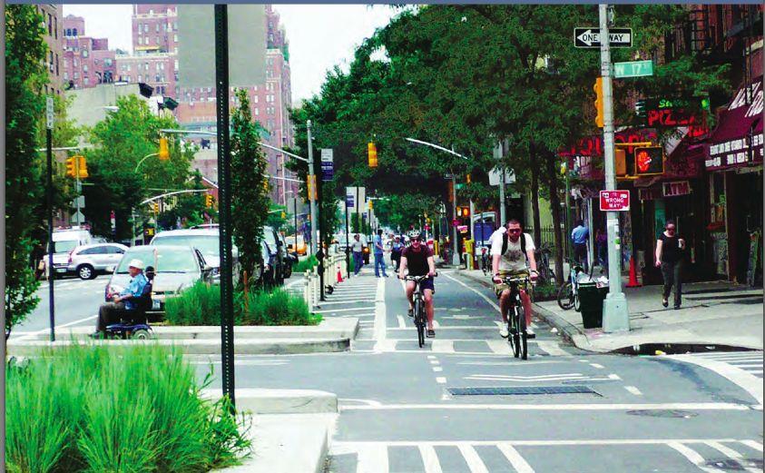
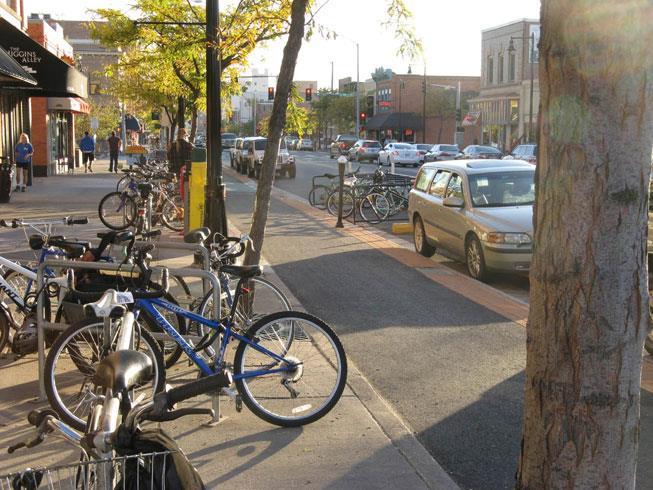
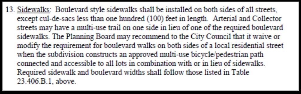
12 SUBDIVISION REGULATIONS How wide does the street network need to be? Is street grid connected and at a walkable scale? Does parkland dedication provide opportunities for recreational activities? e.g. a neighborhood trail system. Are sidewalks required? Are sidewalks accessible, well-lit, and functional?
13 ZONING REGULATIONS Provides the greatest opportunity to promote walkability in all areas, including those previously developed. Zoning can and should foster sound design that defines the character of a community. Must be consistent with goals & objectives within your growth policy, future land use map, other long range plans adopted under GP umbrella
14 YOU HAVE PERMISSION For the purpose of promoting health, safety, morals, or the general welfare of the community, the city or town council or other legislative body of cities and incorporated towns is hereby empowered to regulate and restrict the height, number of stories, and size of buildings and other structures; the percentage of lot that may be occupied; the size of yards, courts, and other open spaces; the density of population; and the location and use of buildings, structures, and land for trade, industry, residence, or other purposes. Criteria and guidelines for zoning regulations. Zoning regulations must be: (a) made in accordance with a growth policy;
15 DESIGN STANDARDS Can be incorporated within or supplemental to zoning regulations Can be encouraged through development incentives Consistency between regulations Standards vs. guidelines
16 DEVELOPMENT INCENTIVES Waive standards requirements when other, highly prioritized design considerations are met. Ex) allow height requirements to be relaxed if developer also creates a public park on a lot. Can be useful to promote cluster development and encourage density. Offer expedited site plan review and approval.

17 BUT.. Grants, loans, private leverage Impact Fees Capital Improvements Plan Tax Increment Financing
18
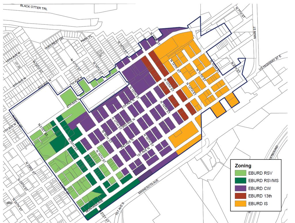
19 BILLINGS EBURD ZONING EBURD RSV: Rail Spur Village District. The Rail Spur Village District is intended to create a walkable neighborhood focused on residential uses with associated green spaces and commercial businesses with the appropriate form.
20 GETTING TO EBURD Billings/Yellowstone Co. Growth Policy (2008) East Billings Urban Renewal Master Plan (2009) EBURD Hybrid Zoning Code Complete Streets Policy (2011) Subdivision Regulations (2013) Long Range Transportation Plan (2014) EBURD TIFD (underway)
21 BILLINGS GROWTH POLICY Transportation alternatives, public health, urban infill highlighted ISSUE IV: Urban sprawl threatens the rural character of land surrounding Billings, increases the cost of providing public services, and threatens the vitality of the city core and Down town. POLICY IV: Coordinate efforts to concentrate development in and adjacent to existing City limits. 3. Encourage the development of neighborhoods, not just housing developments. 4. Provide incentives for urban redevelopment. Strategies may include: a. Fee waivers b. Tax Increment Finance Districts (TIFD) c. Tiered cost of service districts 5. Provide fee and development standard incentives for urban infill development and low to moderate income housing.

22 ISSUE VI: There is a desire for more mixed-use neighborhoods. POLICY VI: Create diverse and vibrant neighborhoods that offer convenient places to work, learn, and shop within walking distance of residences. 1. Consider modifying zoning regulations to include: a. Mixed-use development zones b. Urban village overlay zones c. Performance-based zoning codes1 for major corridors throughout the city to create quality mixed use developments
23 ISSUE: Billings and surrounding County townsites need more multiple use trails. GOAL: A multi-purpose trail network integrated into the community infrastructure that emphasizes safety, environmental preservation, resource conservation and cost effectiveness. OBJECTIVES: Develop non-motorized connections between residential neighborhoods and work places. Provide convenient access to bicycle and pedestrian facilities. Improve quality of life for residents. 4. ISSUE: The design of roads, streets, and pedestrian facilities can be more attractive and functional. GOAL: Visually appealing rights-of-way that serve the needs of all modes of travel. OBJECTIVES: Employ smart, cost effective designs. Use designs that recognize the needs of all users. Incorporate attractive visual elements into rights-of-way design. 4. ISSUE: There are safety and functionality issues with City streets. GOAL: Safe, functional, and attractive streets for all users, including drivers, bicyclists and pedestrians. OBJECTIVES: Enhance public safety on the street. Reduce traffic accidents and congestion.
24
25 ELEMENTS WITHIN PLAN Complete Streets Transportation facilities Infill standards


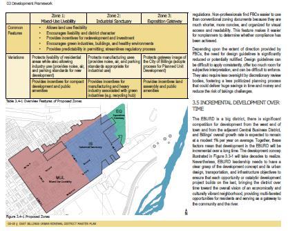
26 FORM BASED CODE An alternative to traditional Euclidean zoning model. Traditionally does not regulate use, though can still restrict some use. Focuses on physical character of an area and neighborhood.
27 FORM BASED CODE Can regulate lot size and building density, but also address issues such as: Setbacks Façade and sidewalk materials Streetlights Off-street parking requirements Can require or encourage the implementation of Complete Streets, CPTED and other environmental design principles
28
29
30
31
32 EBURD TIFD Demolition and abatement of structures and removal of blight Relocation of businesses to EBURD Sidewalks, Curbs, Gutters Public Utilities Water, Wastewater, Stormwater Private Utilities Electrical, Natural Gas, Telecommunication Lines, Fiber Optic Intersection Signals & Hawk Crossings Crosswalks Landscaping & Green Space & Improvement of Pedestrian Areas Historical Restorations Off Street Parking (Must be a public benefit beyond simply increased parking for your business) Pollution Reduction Bridges
33 COMMUNITY TECHNICAL ASSISTANCE PROGRAM (CTAP) PLANNING BUREAU COMMUNITY DEVELOPMENT DIVISION MONTANA DEPARTMENT OF COMMERCE (406)
Future Land Use SAMPLE RECOMMENDATIONS
 SAMPLE RECOMMENDATIONS Future Land Use The Future Land Use Chapter of the Master Plan builds upon prior chapters examining the existing conditions in their respective topic areas to present a comprehensive
Town Center (part of the Comprehensive Plan)
") Town Center (part of the Comprehensive Plan) Mercer Island Town Center Looking North (2014) In 1994, a year-long process culminated in a set of design guidelines and code requirements for the Town Center
Town Center (part of the Comprehensive Plan) Mercer Island Town Center Looking North (2014) In 1994, a year-long process culminated in a set of design guidelines and code requirements for the Town Center
Chapter 3. Community Vision and Goals
 Chapter 3. Community Vision and Goals 3.1 Public Involvement Charlevoix s master plan was prepared in a way that maximized public participation. Dating back to 2004, the Planning Commission and staff held
2030 Comprehensive Plan VISION STATEMENT
 RESOURCE DOCUMENT for Steering Committee Meeting #2 July 12, 2017 2030 Comprehensive Plan VISION STATEMENT Steering Committee from 2008 Established the Lauderdale s Vision as: Creating a livable, lovable
DRAFT Amsterdam/Churchill Community Plan (4/17/08) Adopted By the Gallatin County Commission
 Adopted By the Gallatin County Commission") DRAFT Amsterdam/Churchill Community Plan (4/17/08) Adopted By the Gallatin County Commission Table of Contents Acknowledgements Chapter 1: Introduction A Brief History What s Next Authority Organization
DRAFT Amsterdam/Churchill Community Plan (4/17/08) Adopted By the Gallatin County Commission Table of Contents Acknowledgements Chapter 1: Introduction A Brief History What s Next Authority Organization
TRANSIT-ORIENTED DEVELOPMENT POLICY DRAFT. City Planning and Development Department Kansas City, Missouri
 TRANSIT-ORIENTED DEVELOPMENT POLICY DRAFT City Planning and Development Department Kansas City, Missouri What is Transit Oriented Development (TOD)? Development that focuses land uses around a transit
EXISTING COMPREHENSIVE PLAN
 EXISTING COMPREHENSIVE PLAN Town Center Land Use Element: V. LAND USE POLICIES Town Center Mercer Island's business district vision as described in "Your Mercer Island Citizen-Designed Downtown" was an
People set goals, enjoy striving, and take pleasure in achievement, contribution and association.
 SECTION III STRATEGIES FOR depend upon the fiscal and political climate and the level of citizen involvement in any given year. Therefore, it will be essential that the Municipality review the Action Program
What s in a Name Sustainability, Smart Growth, New Urbanism
 What s in a Name Sustainability, Smart Growth, New Urbanism Published in the Summer 2011 Issue of APA s The Commissioner Pete Pointner FAICP Planning commissioners frequently hear abstract terms bantered
FUTURE LAND USE ELEMENT
 FUTURE LAND USE ELEMENT GOAL I: To create and sustain a great place to live, play, and prosper Objective 1: The City of Ocala shall incorporate the principles and strategies of the Ocala 2035 Vision into
The Five Components of the McLoughlin Area Plan
 The Five Components of the McLoughlin Area Plan This documents contains the complete language of the five components of the McLoughlin Area Plan: The Vision Statement The Values The Guiding Principles
Public Open House. Overview of the Downtown Plan Official Plan Amendment April 23, 2018
 Public Open House Overview of the Downtown Plan Official Plan Amendment April 23, 2018 1 A 25-Year Plan for Downtown To ensure growth contributes positively to Toronto s Downtown as a great place to live,
Comprehensive Plan ADOPTED APRIL 2014
 Comprehensive Plan ADOPTED APRIL 2014 8 8. Outstanding Recreational & Cultural Opportunities We are proud of our community s parks and recreation system. Our community will ensure that the legacy of our
Implementation Guide Comprehensive Plan City of Allen
 Implementation Guide 2030 Comprehensive Plan City of Allen DRAFT 2015 Implementation Guide Allen 2030 Comprehensive Plan INTRODUCTION The Comprehensive Plan serves as a guide for the growth and development
CHAPTER 12 IMPLEMENTATION
 CHAPTER 12 IMPLEMENTATION The 2010 Town of Denton Comprehensive Plan is intended to capture a vision of the future of Denton. As such, it provides a basis for a wide variety of public and private actions
Warren County/Bowling Green Focus 2030 Comprehensive Plan VOLUME 1 INDEX
 Appendix 5: Index VOLUME 1 INDEX A Aesthetics ES-6, FLU-15, FLU-17, FLU-24, NCR-7 Agricultural Base FLU-18, FLU-20 Agricultural Centers, Rural FLU-11 Agricultural District NCR-17-NCR-18 Agricultural Economy
CHAPTER 3 VISION, GOALS, & PLANNING PRINCIPLES. City of Greensburg Comprehensive Plan. Introduction. Vision Statement. Growth Management Goals.
 CHAPTER 3 VISION, GOALS, & PLANNING PRINCIPLES Introduction The Greensburg Comprehensive Plan is intended as a working community document. A combination of long and short-term goals, this document is intended
Route 1 Corridor Study
 Route 1 Corridor Study Westbrook, Connecticut A Vision for the Connecticut Shoreline Public Informational Meeting July 28, 2015 Lower Connecticut River Valley Council of Governments Fitzgerald & Halliday,
Silverdale Regional Center
 Silverdale Regional Center Vision for Silverdale Regional Center The Silverdale Regional Center Plan (Plan) will guide the evolution of the Silverdale Regional Center from a collection of strip malls and
RESIDENTIAL DISTRICTS
 RESIDENTIAL DISTRICTS The residential district standards have been revised to reflect on-the-ground conditions, while continuing to respect the use patterns established within the neighborhoods. This will
PLAN ELEMENTS WORKSHOP. April 5, 2016
 PLAN ELEMENTS WORKSHOP April 5, 2016 needs more housing. But there is no one-size fits-all solution. Every neighborhood has its own character. In some places, density is not only appropriate it is badly
TEMPLE MEDICAL & EDUCATION DISTRICT
 City of Temple, Texas TEMPLE MEDICAL & EDUCATION DISTRICT 1 Description. The City of Temple joined in partnership with key public and private entities to jointly promote education and medical activities
Preservation Planning
 Protect and Maintain the Historic Character of your Community Beverly, West Virginia Randolph County HLC PROTECT Purpose of all work done in survey and registration is not to only register properties.
Port Lavaca Future Land Use
 Port Lavaca Future Land Use Introduction The City of Port Lavaca is beginning to see sustained growth, after many years of relative stable population. New single family homes, apartments, and businesses
Joint Meeting City Council and the Plan Commission. September 1st, 2015
 Joint Meeting City Council and the Plan Commission September 1st, 2015 1 The City Plan Commission shall recommend a City Plan for the physical development of the City Article IX Section 2 of the City of
CHAPTER 7: Transportation, Mobility and Circulation
 AGLE AREA COMMUNITY Plan CHAPTER 7 CHAPTER 7: Transportation, Mobility and Circulation Transportation, Mobility and Circulation The purpose of the Transportation, Mobility and Circulation Chapter is to
Strategic Target: Utilize Pay-For-Use Services Whenever Possible
 2004 Strategic Planning Report The 2003 Strategic Planning Steering Committee compiled and presented this report to the Olathe City Council on March 25, 2004. This is the result of community meetings conducted
Town of Peru Comprehensive Plan Executive Summary
 Town of Peru Comprehensive Plan Executive Communities that plan grow by choice, not by chance. A plan makes growth thoughtful, understandable, and predictable. A plan shows that a community is managing
SECTION II SECTION II STATEMENT OF GOALS, OBJECTIVES, PRINCIPLES, ASSUMPTIONS, POLICIES AND STANDARDS
 STATEMENT OF GOALS, OBJECTIVES, PRINCIPLES, ASSUMPTIONS, POLICIES AND STANDARDS 1 2 STATEMENT OF GOALS, OBJECTIVES, PRINCIPLES, ASSUMPTIONS, POLICIES AND STANDARDS INTRODUCTION The New Jersey Municipal
LAND USE ELEMENT. Purpose. General Goals & Policies
 LAND USE ELEMENT Purpose This Land Use Element contains the goals and policies necessary to support the City s responsibility for managing land resources and guiding development through implementing regulations,
II. SINGLE FAMILY RESIDENTIAL
 II. SINGLE FAMILY RESIDENTIAL Castle Rock is made up of numerous individually built houses and subdivision tracts that have been developed during the past century. Some of the tracts are diverse in architectural
Blueprint Denver Task Force Meeting #16 February 22, 2018
 Blueprint Denver Task Force Meeting #16 February 22, 2018 Agenda Welcome, Meeting Overview and Process Update Change Categories Small Group Recommendations Discussions: Land Use and Built Form General
Status Update (2006 vs. Now) Citizen s Advisory Committee February Plan for Prosperity
 Citizen s Advisory Committee February Plan for Prosperity") Status Update (2006 vs. Now) Citizen s Advisory Committee February 2018 Plan for Prosperity 2000 2017 2000 2017 Gardnerville Population 6,000 5,760 5746 5,500 5,000 5,067 5,550 5,165 5,394 5,412 5,250
Status Update (2006 vs. Now) Citizen s Advisory Committee February 2018 Plan for Prosperity 2000 2017 2000 2017 Gardnerville Population 6,000 5,760 5746 5,500 5,000 5,067 5,550 5,165 5,394 5,412 5,250
City of Bristol Route 6 Corridor Implementation Program
 City of Bristol Route 6 Corridor Implementation Program FITZGERALD & HALLIDAY, INC. Innovative Planning, Better Communities June 2017 Route 6 Corridor Plan IMPLEMENTATION PROGRAM The following Implementation
Gold Line Bus Rapid Transit Transit Oriented Development (BRTOD) Helmo Station Area Plan
 Helmo Station Area Plan") Appendix F Gold Line Bus Rapid Transit Transit Oriented Development (BRTOD) Helmo Station Area Plan Introduction and Purpose of the Plan The Gold Line Bus Rapid Transit facility is an eleven-mile dedicated
Appendix F Gold Line Bus Rapid Transit Transit Oriented Development (BRTOD) Helmo Station Area Plan Introduction and Purpose of the Plan The Gold Line Bus Rapid Transit facility is an eleven-mile dedicated
Volume 2: Implementation Plan
 Volume 2: Implementation Plan February 25 th 2002 Implementation Introduction This document outlines the steps that should be taken to implement the Washington Heights Neighborhood Plan. The City Council
3.9 Systems Interrelationships
 191 Sustainability Building Blocks: The Comprehensive Plan Systems Community Form Economy Social Transportation Natural Resources Housing and Neighborhoods Utilities and Infrastructure Institutions.9 Systems
Keyport. Vision for Keyport
 Keyport Vision for Keyport Keyport is a rural, historic waterfront village bounded and limited in size by its natural borders of water and the Naval Undersea Warfare Center. The community consists primarily
Chapter 1.0 Introduction
 Chapter 1.0 Introduction 1.1 Background The North Metro commuter rail line is part of the RTD FasTracks regional transit system expansion program to build more than 100 miles of rail transit throughout
Municipal Development Plan Update Urban Service Area and Hamlets
 ENCLOSURE 1 Municipal Development Plan Update Urban Service Area and Hamlets Priorities Committee January 24, 2017 MUNICIPAL DEVELOPMENT PLAN UPDATE SHAPING OUR FUTURE MDP Update - Agenda MDP Update Public
SAN RAFAEL GENERAL PLAN 2040 INTRODUCTION AND OVERVIEW
 SAN RAFAEL GENERAL PLAN 2040 INTRODUCTION AND OVERVIEW Steering Committee Presentation February 14, 2018 Purpose of General Plan Guide land use and development decisions Coordinate transportation, infrastructure,
ARTICLE 6: Special and Planned Development Districts
 ARTICLE 6: Special and Planned Development Districts 6-10 Traditional Neighborhood Development (TND) District 6-10.10 Purpose and Intent The Traditional Neighborhood Development (TND) District provides
Introducing the Main Street Strategic Toolbox
 Ulster County Main Streets: A Regional Approach Ulster County Planning Department, 244 Fair Street, Kingston NY 12401 Why do we take a regional approach to Main Streets? There are many different approaches
City of Nogales General Plan
 Open Space, Parks, Recreation and Trails City of Nogales General Plan Residents of Nogales place a high priority in the development of a comprehensive system of open space, parks, recreation and trails
Aesthetics and Design
 University of Connecticut Department of Geography Urban and Regional Planning Lecture 8. Adjunct Lecturer: Donald J. Poland, MS, AICP E-mail: don@donaldpoland.com Web: www.donaldpoland.com Aesthetics and
Proposed Comprehensive Plan Strategies DRAFT for discussion June 28, 2017
 Proposed Comprehensive Plan Strategies DRAFT for discussion June 28, 2017 Land Use Rural Areas Refine the Farm and Forest area (FF) Update FF boundaries to account for existing lots less than five acres
City of Hermosa Beach Administrative Policy #
 City of Hermosa Beach Administrative Policy # SUBJECT: Living Streets Policy Date: Approved by: City Council Authority: Public Works Department & Community Development Department Mayor, PURPOSE The City
Cumberland Region Tomorrow is a private, non-profit, citizen based regional organization working with Greater Nashville Regional Council
 Cumberland Region Tomorrow is a private, non-profit, citizen based regional organization working with Greater Nashville Regional Council and others in the public and private sectors, dedicated to planning
Executive Summary. NY 7 / NY 2 Corridor
 Executive Summary NY 7 / NY 2 Corridor Transportation and Land Use Study December 2005 Prepared for: Town of Colonie Capital District Transportation Committee Prepared by: Introduction: Land use decisions
Roosevelt Corridor. R e i n v e s t m e n t P l a n. Public Meeting Gilbert Elementary School May 12, :00 pm
 Roosevelt Corridor R e i n v e s t m e n t P l a n Public Meeting Gilbert Elementary School May 12, 2009 6:00 pm Agenda 6:00 6:10 6:25 6:40 6:55 7:00 Opening Comments Councilwoman Jennifer V. Ramos District
S A C R A M E N T O C O U N T Y JACKSON HIGHWAY & GRANT LINE EAST VISIONING STUDY
 JACKSON HIGHWAY & GRANT LINE EAST S A C R A M E N T O C O U N T Y P L A N N I N G D E P A R T M E N T SUMMARY AND WORKBOOK November 19, 2008 History of the Visioning Study Sacramento County has two growth
MOUNT BAKER TOWN CENTER: THE 2014 REZONE AND TRANSIT ORIENTED DEVELOPMENT. By Talis Abolins
 MOUNT BAKER TOWN CENTER: THE 2014 REZONE AND TRANSIT ORIENTED DEVELOPMENT By Talis Abolins In 2014, the City of Seattle adopted Ordinance 124513, and created a transit oriented rezone over the area known
Midtown Greenway Land Use and Development Plan Executive Summary
 Midtown Greenway Land Use and Development Plan Executive Summary Introduction The Midtown Greenway Land Use and Development Plan sets policy direction for land use and development in the Midtown Greenway
Ridgefield and the Growth Management Act
 1 2 Ridgefield and the Growth Management Act 3 Why Do We Plan History of Planning in Ridgefield Washington experiences rapid growth in the late 1980 s that began to change the perceived quality of life.
Executive Summary. The goals of the Plan are to:
 Executive Summary The Wiscasset Bath Road Master Plan (Plan) seeks to maximize development opportunities along Bath Road through the strategic coordination of traffic infrastructure improvements, land
SECTION TWO: Urban Design Concepts
 SECTION TWO: Urban Design Concepts The Gardnerville Plan for Prosperity shapes economic opportunities presented by regional growth. The Urban Design Concepts provide policies and concepts for land use,
greenprint midtown SUSTAINABILITY ACTION PLAN 2012
 greenprint midtown SUSTAINABILITY ACTION PLAN 2012 MIDTOWN ALLIANCE SOUTHFACE ENERGY INSTITUTE RENAISSANCE PLANNING GROUP SUSTAINABLE ATLANTA PERKINS+WILL 2 GREENPRINT MIDTOWN 1. Introduction Sustainability
Scorecard. WaterQuality. Appendix B USEPA WATER QUALITY SCORECARD APPENDIX B
 Appendix B USEPA WATER QUALITY SCORECARD EPA 231B09001 October 2009 http://www.epa.gov WaterQuality Scorecard Incorporating Green Infrastructure Practices at the Municipal, Neighborhood, and Site Scales
Official Plan Review
 Official Plan Review Summary Report - The Built Environment August 2014 Part 1: Introduction Planning for a healthy, prosperous and sustainable community is an important goal for our municipality. From
Status Report: MD 355 Project
 Status Report: MD 355 Project OCTOBER 2006 M-NCPPC MONTGOMERY COUNTY PLANNING DEPARTMENT Summary of Community Comments, and break to the Results of the MD 355 Participation Session Brookside Gardens -
Developer s Program. The Station at East 54
 Developer s Program The Station at East 54 Existing Conditions The Station at East 54 is proposed for a 1.12 acre site at the northeast corner of Hamilton Road and Prestwick Road, tucked between the East
Executive Summary. The Mebane CLP is not a regulatory document, but is intended to guide land development decisions. The plan includes:
 Executive Summary P URPOSE AND O RGANIZATION OF THE P LAN The City of Mebane, with input from citizens and an appointed CLP Advisory Committee, adopted Mebane by Design, a Comprehensive Land Development
MIXED-USE VILLAGE OVERLAY FLOATING DISTRICT
 MIXED-USE VILLAGE OVERLAY FLOATING DISTRICT Zoning regulations developed by committee to the Planning Board for the Town of DeWitt, NY Issue date: 13 July 2017 revised 3/12/2018, revised 4/26/2018, 5/9/2018
4 Sustainability and Growth Management
 4 Sustainability and Growth Management Introduction Traditionally, has assumed growth and development with limited consideration for the long-term negative social, environmental or economic impacts on
Safe Routes to School & Master Plans Walkable and Livable Communities Institute
 Safe Routes to School & Master Plans Walkable and Livable Communities Institute Safe Routes to School & Master Plans If you fail to plan, you plan to fail. Why SRTS How Webinar Goal: Advance SRTS in Michigan
2040 LUP is a part of the Comprehensive Plan and carries the same legal authority. Economic Challenges
 1.1. Guiding Anchorage s Growth Where will new residents settle over the next two decades? Where will people work, shop, and play? Will there be enough room to grow? How will Anchorage look? Will growth
Ivywild On The Creek PRELIMINARY CREEK DISTRICT MASTER PLAN
 Ivywild On The Creek PRELIMINARY CREEK DISTRICT MASTER PLAN Introduction: Rejuvenating an extraordinary Creekside neighborhood THE CREEKSIDE DISTRICT The Ivywild On The Creek Neighborhood District Master
Living in Albemarle County s Urban Places
 Living in Albemarle County s Urban Places ALBEMARLE COUNTY, VIRGINIA A Closer Look at Albemarle s Approach to Managing Growth and Creating Quality Urban Environments www.albemarle.org Page 2 Living in
4.1.3 LAND USE CATEGORIES
 4.1.3 LAND USE CATEGORIES a. City Center District The City Center District incorporates the existing character and mix of uses in downtown Belmont to encourage redevelopment and new development in keeping
EXHIBIT A. Tax Increment Reinvestment Zone No. 1 (Town Center) First Amended Project Plan 1
 First Amended Project Plan 1") EXHIBIT A Tax Increment Reinvestment Zone No. 1 (Town Center) First Amended Project Plan 1 1 As amended by Resolution No. 2008-02-001(TR1R) of the Tax Increment Reinvestment Zone No.1, and approved to
EXHIBIT A Tax Increment Reinvestment Zone No. 1 (Town Center) First Amended Project Plan 1 1 As amended by Resolution No. 2008-02-001(TR1R) of the Tax Increment Reinvestment Zone No.1, and approved to
City of Long Beach. creating vibrant and exciting places
 City of Long Beach creating vibrant and exciting places Land Use Element Urban Design Element Overview of the two draft General Plan elements Discuss areas of change Economic goals of the plans Case study
Town of Washington Master Plan & Regulatory Audit: Interim Results
 Town of Washington Master Plan & Regulatory Audit: Interim Results May 20, 2008 Presented by: 30 Bank Street Lebanon, NH 03766 www.uvlsrpc.org Introduction & Purpose Compare the Master Plan to the regulations
In surveys, Dallas residents say what they want to change most
 NEIGHBORHOODS ELEMENT In surveys, Dallas residents say what they want to change most in the city is its appearance they want it to look beautiful, with trees and pedestrian-friendly neighborhoods. The
Transportation Land Use Integration & Regional Planning. Don Kostelec, AICP Senior Planner, Louis Berger Group February 1, 2010
 Transportation Land Use Integration & Regional Planning Don Kostelec, AICP Senior Planner, Louis Berger Group February 1, 2010 Transportation Land Use Integration DOT-HUD-EPA Sustainable Communities Initiative
Chapter 12. Kingston Sub-Area Plan
 Chapter 12. Kingston Sub-Area Plan Kingston is Kitsap County s northern most urban growth area (UGA), located north of Bainbridge Island and Port Madison Bay along Puget Sound. The Kingston UGA was established
New Partners for Smart Growth Conference February 5, 2010
 Dan Stroh, Planning Director City of Bellevue Planning and Community Development Bellevue, WA New Partners for Smart Growth Conference February 5, 2010 Summary of Project Long-range plan update for Bel-Red
Beachside Redevelopment Committee
 Beachside Redevelopment Committee DRAFT FINAL RECOMMENDATIONS MARCH 22, 2018 This is a new slide 2 This is a new slide Table of Contents I. Introduction and Overview II. III. Community Improvements and
Planning Districts INTRODUCTION
 INTRODUCTION To facilitate detailed examination of development prospects for all areas of the community, Delano has been divided into 14 planning districts. The location of these planning districts is
HOUSING ELEMENT GOALS, OBJECTIVES, AND POLICIES
 HOUSING ELEMENT GOALS, OBJECTIVES, AND POLICIES Goal 6 Maintain and enhance the supply of decent, safe, energy efficient and affordable housing and maximize viable options and opportunities for present
Connecting Master Plans, Asset Management, and CIP s to Bolster Economic Development
 Connecting Master Plans, Asset Management, and CIP s to Bolster Economic Development Presented By Paul Montagno, AICP, Carlisle Wartman Associates And Terry Moultane, AICP, Bay City What We re Covering
Plan-It Greenville (2009) Comprehensive Plan 5-Year Update
 Comprehensive Plan 5-Year Update") Plan-It Greenville (2009) Comprehensive Plan 5-Year Update What is the comprehensive plan: Collecting communitywide data Projecting future population growth Setting communitywide goals Framing policies
Plan-It Greenville (2009) Comprehensive Plan 5-Year Update What is the comprehensive plan: Collecting communitywide data Projecting future population growth Setting communitywide goals Framing policies
Broken Arrow Comprehensive Plan Update Public Workshop Meeting #3 January 23,
 Broken Arrow Comprehensive Plan Update Public Workshop Meeting #3 January 23, September 25,2018 2018 26 April 2016 AGENDA 1. Status Presentation - Charrette Recap - Proposed Vision Framework - Preliminary
Tacoma Mall Neighborhood Subarea Plan & EIS. Planning Commission February15, 2017
 Tacoma Mall Neighborhood Subarea Plan & EIS Planning Commission February15, 2017 1 Meeting objectives Commission direction on: Medium and Long-term visions Residential, neighborhood and housing topics
ORANGE COUNTY IMPLEMENTING THE FOUR C s
 ORANGE COUNTY IMPLEMENTING THE FOUR C s East Central Florida Corridor Task Force O R A N G E COUN TY P LA N N I N G DIVISION C O M M U N I T Y, E N V I R O N M E N T A L A N D D E V E L O P M E N T S E
Draft for Public Review. The Market and Octavia Neighborhood Plan
 Draft for Public Review The Market and Octavia Neighborhood Plan San Francisco Planning Department As Part of the Better Neighborhoods Program December 2002 IOverview Why Plan a Better Neighborhood Here
KEY FINDINGS. Community Engagement + Research
 PROJECT OVERVIEW PROJECT OVERVIEW PROJECT OVERVIEW KEY FINDINGS Community Engagement + Research Community Engagement Community Issues Workshop Steering Committee Workshop City Council/Planning Workshop
IMPLEMENTING SOMERSET COUNTY S INVESTMENT FRAMEWORK
 IMPLEMENTING SOMERSET COUNTY S INVESTMENT FRAMEWORK SMART CONSERVATION THROUGH SMART GROWTH NJ LAND CONSERVATION RALLY March 22, 2014 Laurette Kratina, PP, AICP, Supervising Planner Somerset County Planning
CONSENT CALENDAR September 27, 2005
 Office of the Executive Officer September 27, 2005 To: From: Submitted By: Subject: Honorable Chairperson and Members of the Redevelopment Agency Phil Kamlarz, Executive Officer Dan Marks, Director, Planning
3. ELEMENTS OF THE METRO VISION 2035 PLAN
 3. ELEMENTS OF THE METRO VISION 2035 PLAN What is Metro Vision and why does it matter? For more than 50 years, DRCOG has championed a regional perspective on key issues facing the metropolitan area and
The transportation system in a community is an
 7 TRANSPORTATION The transportation system in a community is an important factor contributing to the quality of life of the residents. Without a sound transportation system to bring both goods and patrons
PSRC REVIEW REPORT & CERTIFICATION RECOMMENDATION
 PSRC REVIEW REPORT & CERTIFICATION RECOMMENDATION KITSAP COUNTY COUNTYWIDE PLANNING POLICIES July 2, 2012 BACKGROUND A major emphasis of the Washington State Growth Management Act (GMA) is the need to
Sherri Ferguson. President/CEO Portland Chamber of Commerce. Tennessee Certified Economic Developer Capstone Project
 Sherri Ferguson President/CEO Portland Chamber of Commerce Tennessee Certified Economic Developer Capstone Project Strategic Plan Development for the North Gateway of Portland, Tennessee The New Gateway
III. Design Principles
 III. Design Principles The design of Bay Meadows Phase II has been guided by a series of Urban Design Principles. These principles, informed by consultant site analysis, City staff recommendations, and
Incentive Zoning Regulations Florida Municipal City of Orlando
 Topic: Resource Type: State: Jurisdiction Type: Municipality: Year (adopted, written, etc.): 2002 Community Type applicable to: Title: Incentive Zoning Regulations Florida Municipal City of Orlando Document
Rezoning Issues Setting a Foundation for Zoning Decisions
 Rezoning Issues Setting a Foundation for Zoning Decisions City Council Workshop May 2, 2016 Agenda Goal Need actionable items and sequence of steps Foundation for Zoning Decisions Council Workshop Discussion
Visioning Statement and Guiding Principles
 Visioning Statement and Guiding Principles Planning for the Future The General Plan The General Plan represents Woodland's shared vision of the future and defines a path to lead the community toward its
Making Transit Oriented Development Work For Boonton, NJ
 Making Transit Oriented Development Work For Boonton, NJ Bloustein School of Planning and Public Policy Studio Dan Burton Loannie Dao Webster Slater Brandon Williams Ian Watson Maria Laham Nicola Mammes
FINAL WEST OAKLAND SPECIFIC PLAN & FINAL ENVIRONMENTAL IMPACT REPORT
 1 FINAL WEST OAKLAND SPECIFIC PLAN & FINAL ENVIRONMENTAL IMPACT REPORT Landmarks Preservation Advisory Board Public Hearing June 9, 2014 2 Purpose of LPAB public hearing Provide cultural-resource related
EXECUTIVE SUMMARY DRAFT CHAPTER 1 INTRODUCTION EXECUTIVE SUMMARY
 CHAPTER 1 EXECUTIVE SUMMARY INTRODUCTION Through the joint efforts of the City of Tulsa planning staff and the Land Services division of Indian Nations Council of Governments (INCOG), the Berryhill Land
SUMMERSIDE / MT. CARMEL REINVESTMENT CORRIDOR COMMUNITY DEVELOPMENT STRATEGY
 SUMMERSIDE / MT. CARMEL REINVESTMENT CORRIDOR COMMUNITY DEVELOPMENT STRATEGY FEBRUARY 2013 I. Location of the Summerside/Mt. Carmel Reinvestment Corridor The Summerside/Mt. Carmel Reinvestment Corridor