City of Yelm. Tahoma Terra Final Master Plan Development Guidelines. Table of Contents
|
|
|
- Gwenda Hawkins
- 5 years ago
- Views:
Transcription

1 City of Yelm Tahoma Terra Final Master Plan Development Guidelines Table of Contents Table of Contents... 1 Purpose... 2 Low Density Residential (R4-6)... 3 Moderate Density Residential (R6-10)... 5 Neighborhood Commercial... 7 Streets and Pedestrian Mobility... 9 Potable Water Sanitary Sewer Reclaimed Water Stormwater Landscaping Parks and Recreation Figure 1 - Final Master Site Plan Figure 2 - Street Standards Figure 3 - Street Light Standards Figure 4 - Street Light Pole Specifications Figure 5 - Conceptual Landscaping Plan Figure 6 - Open Space Plan Figure 7- Bio-infiltration Swales (Rain Gardens) Figure 8 - Fence Detail (Pittsburg) Figure 9 - Fence Detail (Allentown) June 28, 2005 Page 1 of 21
2 Purpose The City of Yelm adopted development regulations may be amended in a Master Plan Development. This document is the amended regulations for the first final master site plan of the Tahoma Terra Master Plan Development, being the portion of the property located east of Thompson Creek. The following City of Yelm development regulations are amended through this document: Zoning Code, Title 17 YMC Subdivision Code, Title 16 YMC Critical Areas and Resource Lands, Chapter YMC Development Guidelines, Chapter YMC Design Guidelines The amended development regulations apply to the development of the property at each phase within the final master site plan and is not intended to regulate beyond the initial developer or builder. For example, the amended development regulations would apply to the subdivision of property and the construction of the dwellings within the subdivision, but not to the purchaser of the home. These guidelines ensure that the development of the final master site plan area through the land use permitting process (subdivisions, binding site plans, townhome developments, planned residential developments, and commercial site plan reviews) is consistent with the conceptual master site plan approval and the City s Comprehensive Plan.
3 Low Density Residential (R4-6) Permitted Uses 1 Density Setbacks Residential single family subdivisions Minimum density - 4 dwelling units per gross acre Maximum density - 6 dwelling units per gross acre Front yard - 10 feet Driveway approach - 20 feet Side yard - 5 feet Flanking yard - 10 feet Rear yard - 20 feet Accessory Structures may be located 3 feet from side or rear property lines. Retaining walls, rockeries, and other decorative walls may be permitted within required yards. Building Height Maximum building height shall be 35 feet as measured from the average grade of the subject lot. Off-Street Parking Lot Access Two off street parking spaces shall be provided for each residential dwelling unit. All residential lots shall provide a minimum of 20 foot frontage on a public street. 1 The standards and regulations of the Low Density Residential District (R-4) found at Chapter YMC govern post-development land uses within this district.
4 Model homes Prior to final subdivision approval, the building official may issue a permit for construction of up to six residences for use as model homes. Prior to final plat or site plan approval, such unit may be occupied solely for purposes of promotion of the development and may not be occupied as a residence, until final subdivision approval. Such construction and subsequent occupancy shall only be authorized by the building official upon written finding that the design and placement of the unit would conform with all standards of the City and that fire code and access requirements are met prior to occupancy.
5 Moderate Density Residential (R6-10) Permitted Uses 2 Density Setbacks Residential subdivisions Planned Residential Developments pursuant to Chapter YMC Townhouse Developments pursuant to Chapter YMC Residential Binding Site Plans pursuant to Chapter YMC Minimum density - 6 dwelling units per gross acre Maximum density - 10 dwelling units per gross acre Front yard - 10 feet Driveway approach - 20 feet Side yard - 5 feet Flanking yard - 10 feet Rear yard - 20 feet Accessory structures may be located 3 feet from side or rear yard lines. Retaining walls, rockeries, and other decorative walls may be permitted within required yards. Building Height Maximum building height shall be 35 feet as measured from the average grade of the subject lot. Off-Street Parking Landscaping Two off street parking spaces shall be provided for each residential dwelling unit. Landscaping shall be provided in accordance with Chapter YMC, or as supplemented in the landscaping section of this document, and contain sufficient vegetation to minimize surface water runoff, prevent soil erosion and promote the aesthetic character of the community. 2 The standards and regulations of the Moderate Density Residential District (R-6) found at Chapter YMC govern post-development land uses within this district.
6 Lot Access All residential lots shall provide a minimum of 20 foot frontage on a public street. Residential Binding Site Plans that do not include individual lots (condominiums), Planned Residential Developments, and Townhouse Developments shall provide a commercial access approach to a public street, based on the most current Yelm Development Guidelines. Internal circulation shall be consistent with the requirements of the International Fire Code.
7 Neighborhood Commercial Permitted Uses Setbacks Any use permitted in the Yelm General Commercial Zone pursuant to Chapter YMC. Front - 10 feet from street right-of-way, minimum Side - 10 feet, except 25 feet when adjacent to residential districts Rear 25 feet Design Standards Maximum building height - 42 feet as measured from the average grade of the subject lot. Maximum building size 30,000 gross square feet. Maximum building footprint 16,000 gross square feet. Maximum impervious surface coverage 70 percent. Commercial structures shall be oriented to the public right-of-way. Sidewalks on public streets shall be designed to the Yelm Development Guidelines pedestrian oriented street section. Building setback areas between public street frontages and buildings shall include hardscape improvements such as plaza s and courtyards. Design Guidelines The City of Yelm Design Guidelines for the Old Town District shall apply with special attention given to pedestrian accessibility, orientation of the buildings to the street, architectural features that emphasize building entries and corner treatments.
8 Off-Street Parking Landscaping Lot Access Off street parking shall be provided in accordance with Chapter YMC. Parking lots for commercial structures shall be located behind or along the side of the building (not between the building and the street) and be subject to shared parking agreements for other commercial developments and community events. Landscaping shall be provided in accordance with Chapter YMC, or as supplemented in the Landscaping section of this document, and contain sufficient vegetation to minimize surface water runoff, prevent soil erosion and promote the aesthetic character of the community. All lots within this district shall have legal access to a public street that meets the commercial driveway approach standards in the most current version of the Yelm Development Guidelines.
9 Streets and Pedestrian Mobility Street Standards. Local Access Residential These are local access streets typically found within residential single family subdivisions and serving up to 1,100 trips per day. Other than lighting, all other requirements of the most current version of the Yelm Development Guidelines apply to the local access residential streets in the final master plan. Blocks greater than 660 feet in length shall incorporate traffic calming devices. These devices shall also serve as a visual break to the block through additional landscaping or hardscaping. Local Access Commercial These are local access streets found within the neighborhood commercial area which provide access to commercial buildings. Other than the section and lighting, all other requirements of the most current version of the Yelm Development Guidelines apply to the local access residential streets in the final master plan. At pedestrian oriented locations, the planter strip may be replaced with sidewalk with street trees located in tree grates pursuant to the most current version of the Yelm Development Guidelines. Neighborhood Collector These are streets serving residential subdivisions and are located where the traffic volumes are expected to be between 1,100 and 6000 trips per day. Other than the cross section and lighting, all other requirements of the most current version of the Yelm Development Guidelines apply to the local access residential streets in the final master plan. Major Arterial (boulevard) This is the primary transportation corridor through Tahoma Terra and is designed as a major arterial from Yelm Avenue (SR 510) to the boundary of the Master Plan Development and as a boulevard through the Master Plan Development. This access corridor provides 4 travel lanes and a center turn lane where appropriate. Common, private access Developments which do not require individual building frontage on a public street, such as Townhome Developments or Planned Residential Developments, shall provide common, private access to each building that meets the most current version of the fire codes.
10 Street Lighting. All streets, public or private, shall have street lighting sufficient to provide traffic and pedestrian safety. High mast street lights will be incorporated on the boulevard road and Longmire Street consistent with current standards of the Yelm Development Guidelines. Street lights at the internal street intersections will meet current standards of the Yelm Development Guidelines for height and brightness only. Low mast, or pedestrian scale, street lighting will be installed along the internal portions of the residential streets which will produce an average maintained horizontal illumination of 0.4 foot candles. Design criteria will be consistent with the most current Yelm Development Guidelines Street light ownership. All street lights located within the residential neighborhoods of Tahoma Terra, may be privately installed, and shall be owned and maintained by the Tahoma Terra Home Owners Association. Street lights located along the boulevard and Longmire Street will be owned and maintained by the City of Yelm unless otherwise agreed to by both the City and the developer.
11 Potable Water The most current version of the Yelm Development Guidelines is adopted for all development within the final master site plan. Water meters will be Dialog 3G Wireless RF meters from Master Meter, Inc. Sanitary Sewer The most current version of the Yelm Development Guidelines is adopted for all development within the final master site plan. Reclaimed Water The most current version of the Yelm Development Guidelines is adopted for all development within the final master site plan. Reclaimed water shall be utilized for irrigation use of the community park area, the landscaped areas of the commercial zone and the planter strips located within the Boulevard and any other areas as required by the City through the development review process. Stormwater All stormwater runoff shall be retained, treated and disposed of on-site or disposed of in a system designed for such runoff and which does not flood or damage adjacent properties. Systems designed for runoff retention and control shall be designed consistent with the stormwater manual most currently adopted by the City of Yelm, or shall be provided through bioretention areas (rain gardens) consistent with the Low Impact Development Technical Guidance Manual for Puget Sound, January 2005, as published by the Puget Sound Action Team and Washington State University Pierce County Extension.
12 Landscaping Landscaping shall be provided in accordance with Chapter YMC, except as amended in these sections, and contain sufficient vegetation to minimize surface water runoff, prevent soil erosion and promote the aesthetic character of the community. All public streets will incorporate street trees consistent with the most current version of the Yelm Development Guidelines and Chapter YMC, except as modified as follows: 1. Street trees located along the Boulevard or adjacent to any common open space or park tract shall be maintained by the Tahoma Terra Homeowners Association. 2. Street trees located adjacent to individual lots or residential units, shall be maintained by the adjoining property owner. 3. Planter strips and street trees along local access streets within residential subdivisions shall be installed prior to final building permit approval on the adjacent lot. 4. Planter strips and street trees along local access streets within a commercial district shall be installed prior to issuance of a certificate of occupancy for the commercial use of the adjacent lot. 5. Planter strips and street trees along the Boulevard, along collector streets, and adjacent to open space or commonly owned areas shall be installed prior to acceptance of the street into the City transportation system. Palker brand vinyl fencing and shall be either Allentown slatted fence or Pittsburgh solid fence in the color sand may be substituted for required cedar fencing as part of a type II landscaping buffer.
13 Parks and Recreation Open space requirements for Tahoma Terra will be addressed through the open space plan together with the requirement for neighborhood pocket parks. No less than 3 acres of the active recreational component of the community park shall be constructed prior to final subdivision approval for the first residential development within the final master site plan area. Each residential single family subdivision shall include pocket parks that meet the following standards: The size shall be not less than the average lot size of the lots within the subdivision in which the park is located. An open lawn area should be included. Facilities for active recreation such as, but not limited to, basketball courts, sport court, climbing toys, swing sets or other playground equipment shall be incorporated into every park. Every subdivision shall include at least one park and no less than one park for every 50 dwelling units. A community park within or adjacent to a development within the final master site plan area can be substituted for required pocket parks at a ratio of two pocket parks for every one acre of the community park. Parks should be located throughout the subdivision in a manner to provide convenient and safe access by every dwelling unit to at least one park.


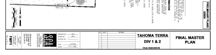
14 Figure 1 - Final Master Site Plan June 28, 2005 Page 14 of 21
15 Figure 2 - Street Standards

16 Figure 3 - Street Light Standards

17 Figure 4 - Street Light Pole Specifications

18 Figure 5 - Conceptual Landscaping Plan


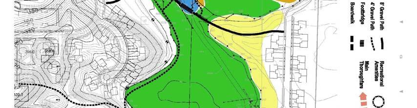
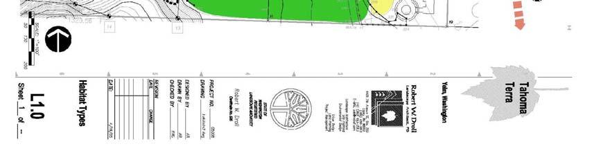
19 Figure 6 - Open Space Plan
20 Figure 7- Bio-infiltration Swales (Rain Gardens)

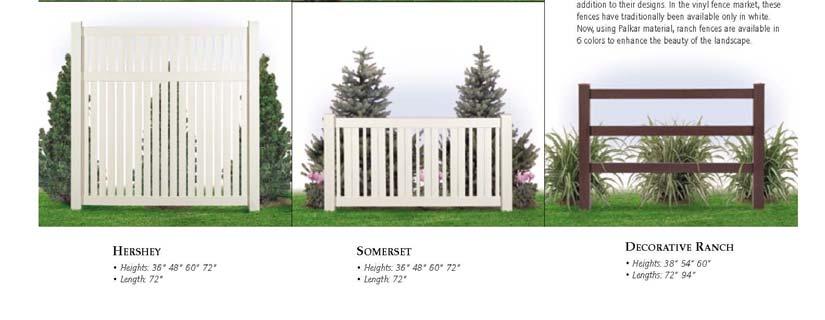
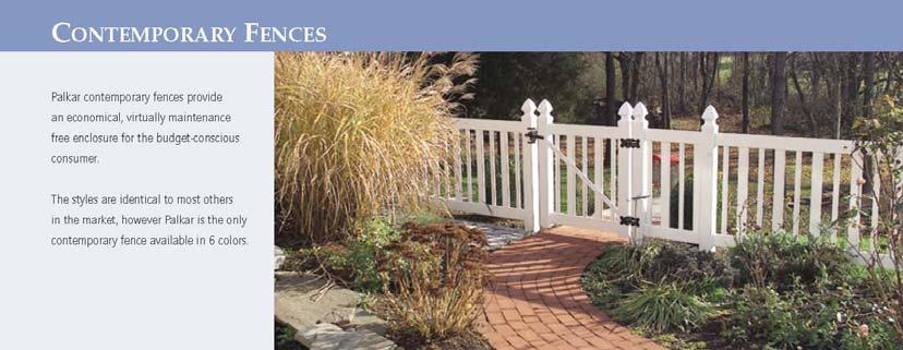
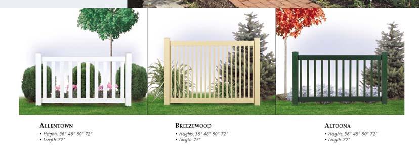
21 Figure 8 - Fence Detail (Pittsburg) Figure 9 - Fence Detail (Allentown)
EXHIBIT B PROJECT NARRATIVE POULSBO MEADOWS
 EXHIBIT B PROJECT NARRATIVE POULSBO MEADOWS Name of Project: Poulsbo Meadows; A Planned Residential Development (PRD)/Plat Applicants Name: PBH Group LLC/Byron Harris PO Box 1010 Silverdale, WA 98038 Description
REZONING APPLICATION MPD SUPPLEMENT
 REZONING APPLICATION MPD SUPPLEMENT For Staff Use Only: DATE/TIMESTAMP: ZA# RECEIVED BY: The intent of the Master Planned District (MPD) designation is to allow flexibility in the design and construction
AWH REPORT OF THE PLANNING AND DEVELOPMENT DEPARTMENT FOR APPLICATION FOR REZONING ORDINANCE TO PLANNED UNIT DEVELOPMENT
 AWH REPORT OF THE PLANNING AND DEVELOPMENT DEPARTMENT FOR APPLICATION FOR REZONING ORDINANCE TO PLANNED UNIT DEVELOPMENT MAY 8, 2014 The Planning and Development Department hereby forwards to the Planning
DRAFT. 10% Common Open Space
 % OF CHARLOTTE IS CATEGORIZED AS A. LAND USES : Placeholder map displaying location of Place Type GOALS: Accommodate XX% of future growth. Provide a concentration of primarily commercial and civic activity
PLANNED UNIT DEVELOPMENT & SUBDIVISION STAFF REPORT Date: May 18, 2017
 & PUD-0000102-2017 PLANNED UNIT DEVELOPMENT & SUBDIVISION STAFF REPORT Date: May 18, 2017 NAME SUBDIVISION NAME Dauphin Creek Estates Subdivision Dauphin Creek Estates Subdivision LOCATION CITY COUNCIL
for Master Planned Development Framework Design Standards & Guidelines
 B L A C K D I A M O N D DE S I G N G U I D E L I N E S for Master Planned Development Framework Design Standards & Adopted June 18, 2009 Introduction and Purpose The Master Planned Development (MPD) Framework
Clarksburg Square Road Extension
 Clarksburg Square Road Extension Preliminary Plan No. 120140060 Site Plan No. 820140050 Site Plan Amendment No. 82007022C (Clarksburg Town Center) Clarksburg SPA Water Quality Plan Mandatory Referral MR2015008
4.1.3 LAND USE CATEGORIES
 4.1.3 LAND USE CATEGORIES a. City Center District The City Center District incorporates the existing character and mix of uses in downtown Belmont to encourage redevelopment and new development in keeping
include playgrounds, sports fields, community gardens and picnic areas.
 DEVELOPMENT PLAN OPEN SPACE SYSTEM OPEN SPACE SYSTEM The neighborhood provides for a range of open space types. The Village Square is an important open space in the neighborhood. It serves as a gathering
SUBMITTAL REQUIREMENTS
 WHEN PROCESS TYPE III IS USED References to Process Type III applications are found in several places in the Milton Municipal Code (MMC), indicating that the development, activity, or use, is permitted
BOULEVARD AND PARKWAY STANDARDS
 88-323 BOULEVARD AND PARKWAY STANDARDS 88-323-01 PURPOSE Considerable public and private investment exists and is expected to occur adjacent to boulevards and parkways within the city. The following standards
ARTICLE V PLANNED UNIT DEVELOPMENT DISTRICT
 ARTICLE V PLANNED UNIT DEVELOPMENT DISTRICT A. Purpose and Objective The Planned Unit Development (PUD) procedure provides a flexible land use and design regulation through the use of performance criteria
understanding Green Infrastructure In Zoning
 understanding Green Infrastructure In Zoning Purpose Measurable standards can be adopted within municipal zoning codes, and subdivision and stormwater regulations, to promote a comprehensive approach to
APPENDIX G: TOWN ORDINANCE REVIEW
 APPENDIX G: TOWN ORDINANCE REVIEW TYLin (225740) Woodard & Curran SWMP January 2013 Stormwater LID strategies, ranked for Zoning Bylaw and Site Plan Review Standards Dimensional Requirements Permit the
Landscape and fencing requirements of this Chapter shall apply to all new landscaped areas.
 Chapter 19.06. Landscaping and Fencing. Sections: 19.06.01. Purpose. 19.06.02. Required Landscaping Improvements. 19.06.03. General Provisions. 19.06.04. Landscaping Plan. 19.06.05. Completion of Landscape
Staff Report to the North Ogden City Planning Commission
 Staff Report to the North Ogden City Planning Commission SYNOPSIS / APPLICATION INFORMATION Application Request: Concept review on a legislative application to rezone land located at approximately 1750
City of Vaughan Urban Design Guidelines for Infill Development in Established Low-Rise Residential Neighbourhoods
 City of Vaughan Urban Design Guidelines for Infill Development in Established Low-Rise Residential Neighbourhoods DRAFT - September 2016 Contents 1. Introduction 1 2. Policy Context 3 3. Characteristics
ARTICLE IV: DEVELOPMENT STANDARDS 404 MASTER PLANNING
 IV 13 404 MASTER PLANNING Master Planning through the Site Analysis (Master Planning Site Analysis) or Planned Development (Master Planning Planned Development) is provided to encourage development which
CITY PLANNING COMMISSION AGENDA ITEM: C STAFF: ROBERT TEGLER FILE NO: CPC PUD QUASI-JUDICIAL
 CPC AGENDA June 8, 2006 Page 37 CITY PLANNING COMMISSION AGENDA ITEM: C STAFF: ROBERT TEGLER FILE NO: CPC PUD 05-294 - QUASI-JUDICIAL PROJECT: APPLICANT: OWNER: PARKWOOD AT WOLF RANCH NASS DESIGN ASSOCIATES
Calumet Town of New Market, Frederick County Maryland
 Community Design Guidelines Bowman Consulting Group, Ltd. - October 2015 Community Founders: Survey, Engineering and Environmental Miller and Smith Bowman Consultingn Group, Ltd. 8401 Greensboro Drive,
ARTICLE 6: Special and Planned Development Districts
 ARTICLE 6: Special and Planned Development Districts 6-10 Traditional Neighborhood Development (TND) District 6-10.10 Purpose and Intent The Traditional Neighborhood Development (TND) District provides
Landscaping Standards
 CHAPTER 29 ARTICLE 403 29.403 Landscaping Standards Purpose: The purpose of this section is to protect and promote the public health, safety and general welfare by requiring landscaping in relation to
Eastcreek Farm. Planned Development Standards September, 2014
 Eastcreek Farm Planned Development Standards September, 2014 ekfarm Contents 01. General Standards 02. Residential Development Standards 03. Architectural Design Standards 04. Landscape Design Standards
Toronto Complete Streets Guidelines
 Toronto Complete Streets Guidelines 108 110 7.1 Green Infrastructure Design Principles 112 7.2 Context-Sensitive Green Streets 114 7.3 Key Green Street Elements Green infrastructure refers to natural and
ARTICLE 13 STREETS General
 ARTICLE 13 STREETS 13.1 General Streets shall be designed to suit their functions. Many streets have purposes other than vehicular traffic. As an alternative to current N.C. Department of Transportation
Application Number: SD Project Name: Walton Farms Preliminary Subdivision (acting as Master Plan)
") STAFF REPORT Town of Clayton Planning Department 111 E. Second Street, Clayton, NC 27520 P.O. Box 879, Clayton, NC 27528 Phone: 919-553-5002 Fax: 919-553-1720 Planning Board May 22, 2017 Application Number:
STAFF REPORT Town of Clayton Planning Department 111 E. Second Street, Clayton, NC 27520 P.O. Box 879, Clayton, NC 27528 Phone: 919-553-5002 Fax: 919-553-1720 Planning Board May 22, 2017 Application Number:
ARTICLE 17 SITE PLAN REVIEW
 ARTICLE 17 SITE PLAN REVIEW 17.01 INTENT AND PURPOSE The intent of this section is to provide for consultation and cooperation between the applicant and the township planning commission so that the applicant
NEW CASTLE COUNTY S ZONING DISTRICTS
 NEW CASTLE COUNTY S ZONING DISTRICTS This is general information about New Castle County s zoning districts. The information included is by no means exhaustive or complete. Before designing plans to develop
North Oakville East Parks Facilities Distribution Plan. November, 2009
 North Oakville East November, 2009 POLICY CONTEXT 1) Purpose a) The purpose of this document is to be a guide for the location, configuration, design and development of the parks system for the North Oakville
WAYNE GLEN (also known as the Richter Property) A model Low Impact Development (LID) community.
 A model Low Impact Development (LID) community.") WAYNE GLEN (also known as the Richter Property) A model Low Impact Development (LID) community. Sketch Plan Submission Tredyffrin Planning Commission i Meeting January 17, 2013 114 Forrest Avenue, Suite
WAYNE GLEN (also known as the Richter Property) A model Low Impact Development (LID) community. Sketch Plan Submission Tredyffrin Planning Commission i Meeting January 17, 2013 114 Forrest Avenue, Suite
LOW DENSITY RESIDENTIAL
 LOW DENSITY RESIDENTIAL Corner lots with coach houses to increase diversity, provide unity to the streetscape and increase eyes on the street. Garages and ancillary units accessed via rear lanes. Parking
Appendix E: Illustrative Green Infrastructure Examples
 Appendix E: Illustrative Green Infrastructure Examples Integrating LID into San Francisco s Urban Landscape Figure E. High-density Residential Figure E. Low-density Residential Figure E. Mixed Use 7 Figure
D. Landscape Design. 1. Coverage Intent: To provide adequate landscaping materials that enhance the appearance of development projects.
 D. Landscape Design The standards and guidelines in this section give design guidance for the landscaping components of industrial and office projects. City regulations require that all landscaping be
3700. OLD HOMOSASSA AREA REDEVELOPMENT PLAN STANDARDS. Aesthetic standards are mandatory for nonresidential projects only.
 3700. OLD HOMOSASSA AREA REDEVELOPMENT PLAN STANDARDS Aesthetic standards are mandatory for nonresidential projects only. 3701. PURPOSE AND INTENT The purpose of this section is to establish those supplemental
CHESAPEAKE LANDSCAPE ORDINANCE
 CHESAPEAKE LANDSCAPE ORDINANCE CONSERVATION PRESERVATION CZO 19-600 Effective October 16, 2008 BUFFER YARD C PARKING LOT REFORESTATION YEAR 1 REFORESTATION YEAR 4 BUFFER YARD F CBPA REFORESTATION Page
The subject site plan amendment proposes the following revisions to the approved site plan:
 PROPOSED AMENDMENT The subject site plan amendment proposes the following revisions to the approved site plan: 1. The building footprint was modified to accommodate the revised architectural design. 2.
OPEN SPACE TYPES. SIZE 8 acres. SIZE 20 acres. SIZE 1 acre
 TYPICAL CHARACTERISTICS OPEN SPACE TYPES OPEN SPACE TYPES The neighborhood contains an extensive variety of open space types. Most of these spaces incorporate multiple uses and activities, so that each
CITY OF KEIZER MASTER PLAN APPLICATION & INFORMATION SHEET
 CITY OF KEIZER MASTER PLAN APPLICATION & INFORMATION SHEET PRE-APPLICATION CONFERENCE Prior to the actual filing of a Master Plan application, it is strongly recommended that the applicant contact Planning
City of Kelowna Consolidated Zoning Bylaw No. 8000
 Section 7 Landscaping and Screening 7.1 Required Landscaping 7.1.1 The minimum level of landscaping required in each zone along all front, rear and side yards shall be determined from the Minimum Landscape
LIST OF TABLES, FIGURES AND APPENDICES
 LIST OF TABLES, FIGURES AND APPENDICES Chapter Page 2 INTERPRETATION FIGURE 2.1 SAMPLE AWNING...2.8 FIGURE 2.2 SAMPLE LOW-RISE APARTMENT DESIGN...2.9 FIGURE 2.3 SAMPLE DUPLEX DESIGN...2.10 FIGURE 2.4 SAMPLE
VILLAGE OF CLEMMONS PLANNING BOARD DRAFT STAFF REPORT
 VILLAGE OF CLEMMONS PLANNING BOARD DRAFT STAFF REPORT PETITION INFORMATION Docket # C-226 Staff Megan Ledbetter Petitioner(s) JBJH Properties, LLC Owner(s) JBJH Properties, LLC Subject Property 5892-49-1766
I403 Beachlands 1 Precinct
 I403. Beachlands 1 I403.1. Precinct Description Beachlands is a rural and coastal village located on the eastern side of Auckland, adjoining the Tamaki Strait coastline. The original Beachlands village
R E S O L U T I O N. Single-Family Residence/ Church. 2,488 sq. ft. 2,488 sq. ft. Area Parking Required: Church
 R E S O L U T I O N WHEREAS, the Prince George s County Planning Board is charged with the approval of Detailed Site Plans pursuant to Part 3, Division 9 of the Zoning Ordinance of the Prince George s
ARTICLE 13 STREETS General
 ARTICLE 13 STREETS 13.1 General Streets shall be designed to suit their functions. Many streets have purposes other than vehicular traffic. As an alternative to current N.C. Department of Transportation
3.4 REL: Religious Use District
 3.4 Intent - The s are established to promote and maintain the development facilities for divine worship within the Town of Plainfield. The development of religious facilities or the major expansion of
General Location Courtyard at LMH Final Development Plan and Final Plat
 R-1 LEYDEN RIDGE LOMA RIDGE LOBDELL R-3 MILLER PARKWAY LAUSSAC Subject Property R-3 LOCHENSHIRE LESMER R General Location Courtyard at LMH Final Development Plan and Final Plat ¹ 230 115 0 230 Feet Airport
Transportation. Strategies for Action
 Transportation A major priority for the Overlake Neighborhood is to develop a multimodal transportation system. To achieve this system, a balance has to be found among travel, circulation and access needs;
4 C OMMUNITY D ISTRICTS
 4 C OMMUNITY D ISTRICTS N ew development in the Area will include many different types of land uses, including a destination retail area that attracts people from all over the region; recreation opportunities
Metropolitan Area Planning Council 60 Temple Place, Boston, Massachusetts fax
 Metropolitan Area Planning Council 60 Temple Place, Boston, Massachusetts 02111 617-451-2770 fax 614-482-7185 www.mapc.org Serving the 101 Cities and Towns in the Metropolitan Boston Region MEMORANDUM
Baumgarten MPUD. Exhibit 3 Evaluation Criteria
 Pursuant to LDC subsections 10.02.13 B, 10.02.08 F and Chapter 3 G. of the Administrative Code, staff s analysis and recommendation to the Planning Commission, and the Planning Commission s recommendation
VILLAGE OF CLEMMONS PLANNING BOARD DRAFT STAFF REPORT. Single Family Residential, Townhomes
 VILLAGE OF CLEMMONS PLANNING BOARD DRAFT STAFF REPORT PETITION INFORMATION Docket # C-212 Staff Megan Ledbetter Petitioner(s) Peacehaven Development LLC Owner(s) Larry Jarvis, William Alexander and Peacehaven
BYLAW C A Bylaw of Rocky View County to amend Land Use Bylaw C
 BYLAW C-7720-2017 A Bylaw of Rocky View County to amend Land Use Bylaw C-4841-97. The Council of Rocky View County enacts as follows: PART 1 TITLE This Bylaw shall be known as Bylaw C-7720-2017. PART 2
TOP TEN LIST OF COMMUNITY CONCERNS REGARDING PROPOSED AMENDMENTS TO CHAPTER 42
 TOP TEN LIST OF COMMUNITY CONCERNS REGARDING PROPOSED AMENDMENTS TO CHAPTER 42 1. Extend the urban area to Beltway 8 in stages, over say a three-year period, prioritizing development in transit and declining
MIXED-USE VILLAGE OVERLAY FLOATING DISTRICT
 MIXED-USE VILLAGE OVERLAY FLOATING DISTRICT Zoning regulations developed by committee to the Planning Board for the Town of DeWitt, NY Issue date: 13 July 2017 revised 3/12/2018, revised 4/26/2018, 5/9/2018
SUBDIVISION, REZONING, PLANNING APPROVAL, PUD & SIDEWALK WAIVER STAFF REPORT Date: May 3, 2007
 SUBDIVISION, REZONING, PLANNING APPROVAL, PUD & SIDEWALK WAIVER STAFF REPORT Date: May 3, 2007 APPLICANT NAME SUBDIVISION NAME LOCATION TOG Properties, LLC Highland Professional Park, Resubdivision of
Metropolitan Area Planning Council 60 Temple Place, Boston, Massachusetts fax
 Metropolitan Area Planning Council 60 Temple Place, Boston, Massachusetts 02111 617-451-2770 fax 614-482-7185 www.mapc.org Serving the 101 Cities Towns in the Metropolitan Boston Region MEMORANDUM TO:
BRANAN FIELD MASTER PLAN
 EXHIBIT L BRANAN FIELD MASTER PLAN GOALS, OBJECTIVES AND POLICIES Table of Contents Section Page 1. Future Land Use Element...1 2. Transportation Element...17 3. Recreation and Open Space Element...21
4030 COMMERCIAL (C AND CM)
") 4030 COMMERCIAL (C AND CM) 4030.10 Intent and Purpose The C and CM districts are intended to permit the range of commercial uses in areas which are appropriate for such uses consistent with the General
4030 COMMERCIAL (C AND CM) 4030.10 Intent and Purpose The C and CM districts are intended to permit the range of commercial uses in areas which are appropriate for such uses consistent with the General
CHAPTER 22 Rural Open Space Community Developments
 CHAPTER 22 Rural Open Space Community Developments Section 22.1 Description and Purpose The intent of this Chapter is to offer property owners an alternative to traditional zoning requirements for rural
Approved: CITY OF ARDEN HILLS, MINNESOTA PLANNING COMMISSION WEDNESDAY, AUGUST 5, :30 P.M. - ARDEN HILLS CITY HALL
 Approved: CITY OF ARDEN HILLS, MINNESOTA PLANNING COMMISSION WEDNESDAY, AUGUST 5, 2015 6:30 P.M. - ARDEN HILLS CITY HALL PLANNING CASES A. Planning Case 15-016; Final Planned Unit Development Arden Plaza;
Request Alternative Compliance to the prescribed criteria of the Oceanfront Resort District Form-Based Code. Staff Planner Kristine Gay
 Applicant/Owner Ocean Rental Properties, LLC Public Hearing April 13, 2016 City Council Election District Beach Agenda Item 1 Request Alternative Compliance to the prescribed criteria of the Oceanfront
URBAN DESIGN BRIEF URBAN DESIGN BRIEF 721 FRANKLIN BLVD, CAMBRIDGE August 2018
 URBAN DESIGN BRIEF URBAN DESIGN BRIEF 721 FRANKLIN BLVD, CAMBRIDGE August 2018 DESIGN BRIEF CONTENTS PART A 1.0 INTRODUCTION 2.0 DESCRIPTION & ANALYSIS OF SITE CONTEXT 3.0 DESIGN CONSTRAINTS AND OPPORTUNITIES
Sec Intent and purpose.
 1 of 5 10/12/2012 10:33 AM Hastings, Michigan, Code of Ordinances >> PART II - CODE OF ORDINANCES >> Chapter 90 - ZONING >> ARTICLE XII. - LANDSCAPING >> ARTICLE XII. - LANDSCAPING Sec. 90-1006. - Intent
Section 9 NEIGHBORHOOD DESIGN
 Section 9 NEIGHBORHOOD DESIGN City of Lancaster Comprehensive Plan D u n k i n, S e f k o & A s s o c i a t e s, I n c. NEIGHBORHOOD DESIGN INTRODUCTION There are many ways in which a neighborhood can
PRELIMINARY PLAT DESIGN REQUIREMENTS Updated 4/8/2016
 PRELIMINARY PLAT DESIGN REQUIREMENTS Updated 4/8/2016 The following items are required for the preliminary plat. Numbers correspond with those on the example preliminary plat. RENO COUNTY SUBDIVISION REQUIREMENTS
The West Vaughan Employment Area Secondary Plan Policies
 Part 2: The West Vaughan Employment Area Secondary Plan Policies 2.1 General Policies It is the policy of Council: 2.1.1. That the West Vaughan Employment Area (the WVEA), identified on Schedule 1, will
Required Internal Landscaping Percentage of Ground Cover in Living Materials Percentage of Tree Size
 CHAPTER 12-24 LANDSCAPE STANDARDS 12-24-101 Purpose 12-24-102 Landscaping Required 12-24-103 Parking Lot Screening 12-24-104 Parking Lot Trees 12-24-105 12-24-106 Landscaped Setbacks Buffers 12-24-107
GENERAL INFORMATIONaaaaaaaaaaaaaaaaaaaaaaaaaaaaaaaa
 To: Planning and Zoning Commission From: City Staff Date: November 15, 2016 Re: Case #16026 Raymore Activity Center Site Plan GENERAL INFORMATIONaaaaaaaaaaaaaaaaaaaaaaaaaaaaaaaa Applicant/ Property Owner:
DCA , Stormwater Quality and Facilities Ordinance June 23, 2009
 PROPOSED NEW SECTION 10.486 Stormwater Quality and Detention Facilities, Public Streets. A. Purpose. It is the City s policy to maintain the natural hydrology and preserve water quality by mitigating the
KASPER. City of Georgetown, Texas PUD Planned Unit Development. December 30, 2015 Revised January 27, 2016
 KASPER City of Georgetown, Texas PUD Planned Unit Development December 30, 2015 Revised January 27, 2016 Applicant: Sentinel Land Company, LLC 4910 Campus Drive Newport Beach, CA Prepared by: SEC Planning
Dwelling Units Max 12 dwelling units per acre/min 8 dwelling units per acre. Development Mix 80% non residential/20% residential
 13. OSTEEN LOCAL PLAN Background: The Osteen Local Plan area is located in southwest Volusia County along the SR 415 corridor between Lemon Bluff Road and Acorn Lake Road and includes 3,990 acres. The
URBAN DESIGN BRIEF. 2136&2148 Trafalgar Road. Town of Oakville
 URBAN DESIGN BRIEF 2136&2148 Trafalgar Road Town of Oakville Prepared By: METROPOLITAN CONSULTING INC For 2500674 Ontario Inc November 2016 TABLE OF CONTENTS Page No. 1.0 Introduction/Description of Subject
Planned Residential Neighborhoods Land Use Goals
 Planned Residential Neighborhoods Land Use Goals Issue: Guidelines that provide for diverse high quality residential areas that include a variety of housing styles and layouts are needed. Goal 1: Create
Major Subdivision Sketch Plan Checklist
 This checklist provides specific requirements that are apart of the Sketch process. The entire process is described by the Huntersville Subdivision Review Process which details all the submittal and resubmittal
Chapter PEDESTRIAN COMMERCIAL (PC) ZONING DISTRICT
 ZONING DISTRICT") Chapter 11-17 PEDESTRIAN COMMERCIAL (PC) ZONING DISTRICT Sections: 11-17-01 GENERAL PURPOSE 11-17-02 PERMITTED BUILDING TYPES 11-17-03 USES PERMITTED WITH DESIGN REVIEW 11-17-04 USES PERMITTED BY CONDITIONAL
Chapter 11-17 PEDESTRIAN COMMERCIAL (PC) ZONING DISTRICT Sections: 11-17-01 GENERAL PURPOSE 11-17-02 PERMITTED BUILDING TYPES 11-17-03 USES PERMITTED WITH DESIGN REVIEW 11-17-04 USES PERMITTED BY CONDITIONAL
PLANNED UNIT DEVELOPMENT Date: April 5, 2018
 PLANNED UNIT DEVELOPMENT Date: April 5, 2018 DEVELOPMENT NAME SUBDIVISION NAME LOCATION Robert Myers Robert Myers 2955 and 2989 Dauphin Street (Southeast corner of Dauphin Street and Sage Avenue) CITY
B L A C K D I A M O N D D E S I G N G U I D E L I N E S for Multi-family Development
 B L A C K D I A M O N D D E S I G N G U I D E L I N E S for Multi-family Development Adopted June 18, 2009 This section of the Design and focuses on site planning and design guidance for new multi-family
Rapid City Planning Commission Rezoning Project Report
 Rapid City Planning Commission Rezoning Project Report April 5, 2018 Item # 4 Applicant Request(s) Case # 18RZ008 Rezoning request from General Agricultural District to Low Density Residential District
3.1 community vision. 3.3 required plan elements
 Chapter 3 Community Form 3.1 community vision 3.2 Parks & landscaping concepts 3.3 required plan elements D R A F T 20 Community Form Chapter 3 3.0 Community form 3.1 community vision The Specific Plan
UNIVERSITY OF MICHIGAN:
 Chapter Eight UNIVERSITY OF MICHIGAN: North Campus I. Introduction The University of Michigan currently owns approximately 800 acres of land in the northeast section of Ann Arbor. North Campus refers to
EXHIBIT. PUD Written Description
 EXHIBIT D PUD Written Description Krispy Kreme at Merrill Road PUD Revised 09-30-2013 City Development Number: I. PROJECT DESCRIPTION The subject property identified as Real Estate No.120466 0030 on Panel
DEFINITIONS AND RULES OF MEASUREMENT DEFINITIONS AND RULES OF MEASUREMENT 7-1
 7 DEFINITIONS AND RULES OF MEASUREMENT DEFINITIONS AND RULES OF MEASUREMENT 7-1 DEFINITIONS Abutting or Adjoining. Having a common boundary, except that parcels having no common boundary other than a common
MIDTOWN MIXED-USE VILLAGE. TECHNICAL DATA SHEET COMPONENT C-1 FOR PUBLIC HEARING - PETITION NUMBER Project No RZ1.1. Issued.
 N MIDTOWN MIXED-USE VILLAGE TECHNICAL DATA SHEET COMPONENT C- FOR PUBLIC HEARING - PETITION NUMBER 04-00 Project No. 496 Issued Revised SCALE: " = 0' N 0 0 0 40 RZ. c GENERAL PROVISIONS: a. SITE LOCATION.
OFFICE CONSOLIDATION SECONDARY PLAN AREA 22 THE BRAMALEA SOUTH INDUSTRIAL SECONDARY PLAN
 OFFICE CONSOLIDATION SECONDARY PLAN AREA 22 THE BRAMALEA SOUTH INDUSTRIAL SECONDARY PLAN November 2010 EXPLANATORY NOTES (Secondary Plan Area 22) General (pertaining to all secondary plan office consolidations)
Mitchell Ranch South MPUD Application for Master Planned Unit Development Approval Project Narrative. Introduction
 Mitchell Ranch South MPUD Application for Master Planned Unit Development Approval Project Narrative Introduction Mitchell Ranch South is a proposed single family (detached) residential development on
ARTICLE 3 LANDSCAPING AND SCREENING REQUIREMENTS
 ARTICLE 3 CHAPTER 4 LANDSCAPING AND SCREENING REQUIREMENTS SEC 3.401 SEC 3.402 (D) (E) PURPOSE: The purpose of this Chapter is to establish minimum standards for the design, installation, and maintenance
Development Services Staff Report for Design Review Committee
 Development Services Staff Report for Design Review Committee To: Design Review Committee From: DS Staff: Erika Akin Subject: Proposed Addition to J s Car Wash File: DSRFY2016-1 Date: January 19, 2016
IV. Development Standards
 IV. Development Standards Seattle Children s proposes development standards to govern physical development within the MIO boundaries. As a supplement to the proposed development standards, Children s proposes
CHAPTER ADDITIONAL REQUIREMENTS IN THE NC, NEIGHBORHOOD COMMERCIAL ZONE
 CITY OF MOSES LAKE MUNICIPAL CODE CHAPTER 18.31 ADDITIONAL REQUIREMENTS IN THE NC, NEIGHBORHOOD COMMERCIAL ZONE Sections: 18.31.010 Purpose 18.31.020 Minimum Lot Area 18.31.030 Setbacks 18.31.040 Maximum
TENTATIVE MAP CHECKLIST
 Business License 707.648.4357 www.cityofvallejo.net Central Permit Center 555 Santa Clara Street Vallejo CA 94590 Building 707.648.4374 Planning 707.648.4326 TENTATIVE MAP CHECKLIST Public Works/Engineering
Chesapeake Bay Critical Area Conservation Plan
 The Maryland-National Capital Park and Planning Commission Prince George s County Planning Department Development Review Division 301-952-3530 Note: Staff reports can be accessed at www.mncppc.org/pgco/planning/plan.htm.
THE CITY OF VAUGHAN BY-LAW BY-LAW NUMBER
 THE CITY OF VAUGHAN BY-LAW BY-LAW NUMBER 123-2013 A By-law to designate the whole of the City of Vaughan as a Site Plan Control Area, and to adopt site development guidelines and rules of procedure for
STATEMENT OF JUSTIFICATION CLARKSBURG PREMIUM OUTLETS AT CABIN BRANCH NORTH DISTRICT, PHASE
 STATEMENT OF JUSTIFICATION CLARKSBURG PREMIUM OUTLETS AT CABIN BRANCH NORTH DISTRICT, PHASE 1 Southwest Corner of Clarksburg Road and Interstate-270 Clarksburg, Maryland Application for Site Plan #820140160
E. Natural areas include habitats such as wetlands, tidal marshes, waterways, natural drainage-ways, woodlands and grassland meadows.
 Adopted November 1999 I. Purpose A. The purpose of these guidelines is to assist in the design and layout of open space, as provided on developed lots within the District. The intent of these guidelines
THE CITY OF MOBILE, ALABAMA
 THE CITY OF MOBILE, ALABAMA LETTER OF DECISION Ark of Safety, Inc. Mobile, AL 36617 Re: (Northwest corner of Main Street and First Avenue, extending to the Southwest corner of Esau Avenue and Main Street.)
Gold Line Bus Rapid Transit Transit Oriented Development (BRTOD) Helmo Station Area Plan
 Helmo Station Area Plan") Appendix F Gold Line Bus Rapid Transit Transit Oriented Development (BRTOD) Helmo Station Area Plan Introduction and Purpose of the Plan The Gold Line Bus Rapid Transit facility is an eleven-mile dedicated
Appendix F Gold Line Bus Rapid Transit Transit Oriented Development (BRTOD) Helmo Station Area Plan Introduction and Purpose of the Plan The Gold Line Bus Rapid Transit facility is an eleven-mile dedicated
Supplemental Design Guidelines
 Supplemental Design Guidelines 65 SUPPLEMENTAL DESIGN GUIDELINES As a supplemental reference to the project, the following diagrams are included to illustrate the site planning approaches that were followed
Urban Design Guidelines Townhouse and Apartment Built Form
 Urban Design Guidelines Townhouse and Apartment Built Form Town of Wasaga Beach Table of Contents 1. Introduction 1.1. Purpose 1.2. Urban Design Principles 1.3. Application of Guidelines 2. Site Design,
CHAPTER 4 - LAND USE CLASSIFICATIONS
 CHAPTER 4 - LAND USE CLASSIFICATIONS Four new land use classification categories are established in the Gualala Town Plan: Gualala Village Mixed Use; Gualala Highway Mixed Use; Gualala Planned Development
BRANAN FIELD MASTER PLAN
 EXHIBIT L BRANAN FIELD MASTER PLAN GOALS, OBJECTIVES AND POLICIES Table of Contents Section Page 1. Future Land Use Element... 1 2. Transportation Element... 17 3. Recreation and Open Space Element...