Concept Evaluations 2 May 2009
|
|
|
- Alisha Brown
- 5 years ago
- Views:
Transcription
1 Concept Evaluations 2 May 2009
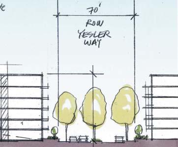
2 Evaluation Purpose The purpose of this evaluation is to gain feedback from the CRC and community on the ideas presented within the concepts and how the concepts relate to the surrounding neighborhoods. The evaluations and comments from this exercise will be summarized and refined by the CRC in your next two meetings. The results will be presented to the SHA Board, in addition to other materials, for their consideration in August. There are certain details that are the same in each concept. These details include: Planning program (4,000 dwelling units, 1,000,000 sq. ft. of office, 50,000 sq. ft. of retail) 561 very low income public housing units, affordable and market rate housing Parking will be provided as required All concepts have housing for families and home day care providers at or near ground level Sustainable infrastructure and buildings will be evaluated in future plans 5-8 acres of public, accessible open space Yesler Way improved for connecting east/west through the site Broadway, Boren and Yesler Way street alignment remains The evaluation form has its roots in the guiding principles and planning concepts adopted by the CRC. The matrix shows which guiding principles and planning concepts (bold type) can be physically evaluated in the concept variables. Some guiding principles are programmatic in nature, such as Promote the creation of a micro-loan program. Some guiding principles will be addressed in the future, such as Phase development to minimize resident disruption. The evaluation criteria were then organized under the seven concept variables. The Seattle Housing Authority and consulting team is dedicated to ensuring that all guiding principles and planning concepts will be fulfilled with the redevelopment of Yesler Terrace. GUIDING PRINCIPLES SOCIAL EQUITY 1. Promote a culturally and economically diverse community. 2. Include stakeholder involvement in major decisions. 3. Provide resources to improve economic, cultural and social opportunities. 4. Foster positive interactions throughout Yesler Terrace and the community at large. 5. Promote social equity by encouraging inclusion of complementary social, educational and health services 6. Meet the housing needs of current and future generations living within Yesler Terrace 7. Preserve and expand very low income housing opportunities for current public housing eligible residents. 8. Minimize impacts of displacement for residents during the redevelopment process. 9. Create a neighborhood that provides recreational and educational opportunities and services. 10. Utilize the City housing inventories and other resources to avoid displacement from the neighborhood. 11. Establish a community governance structure that promotes involvement in decision making by all residents. ECONOMIC OPPORTUNITY 12. Support creation of living wage jobes for residents. 13. Assist residents in transitioning out of subsidized housing. 14. Strengthen partnerships with social service agencies and institutions. 15. Engage in partnerships to assist homeless families. TOPOGRAPHY LAND USE RETAIL LAND USE OFFICE CIRCULATION OPEN SPACE HEIGHT / MASSING 16. Promote the creation of a micro loan program or other access to capital to support residents. 17. Preserve and foster home businesses for all residents within Yesler Terrace. 18. Support training, apprenticeship and living wage job opportunities for residents. 19. Preserve and promote small businesses adjacent to Yesler Terrace. ENVIRONMENTAL STEWARDSHIP AND SUSTAINABILITY 20. Incorporate smart growth principles in the redevelopment process. 21. Foster a safe and healthy community by incorporating a variety of housing styles, sizes and configurations. 22. Incorporate urban design and architectural techniques that promote pedestrian interation and positive relations. 23. Use environmentally friendly and sustainable building techniques to produce healthy and quality housing. 24. Foster education and awareness programs that promote earth friendly practices. 25. Ensure that low income families, the elderly and those with disabilities are served. CONCEPT VARIABLES CONNECTIONS / EDGES
3 CONCEPT VARIABLES GUIDING PRINCIPLES ONE FOR ONE REPLACEMENT HOUSING 26. Design housing mix based on geographic growth projections. 27. Provide the best possible affordable housing the offers choice, options, affordability and access to amenities. 28. Consider expanding site boundaries in the immediate neighborhood and increase density. 29. Phase development to minimize resident disruption and construction impacts. 30. Include residents in the housing design and development decisions. 31. Provide nearby affordable housing relocation options and assistance when necessary. 32. Provide replacement housing at costs consistent with public housing rent formulas. 33. Ensure reasonable physical accessibility within Yesler Terrace for all residets 34. If the footprint of Yesler Terrae is expanded, any lost units will be replaced in the neighborhood. 35. Pursue those alternative s for Yesler Terrace which will result in the greatest balance 36. Encourage innovative home ownership opoprtunities for low income people on site. PLANNING CONCEPTS 1. Community Heart 2. Main Street 3. Broadway Linkages 4. Complete Streets 5. Leverage Density 6. Mixed Use Activity 7. Fit Naturally 8. Open Spaces TOPOGRAPHY LAND USE RETAIL LAND USE OFFICE CIRCULATION OPEN SPACE HEIGHT / MASSING CONNECTIONS / EDGES

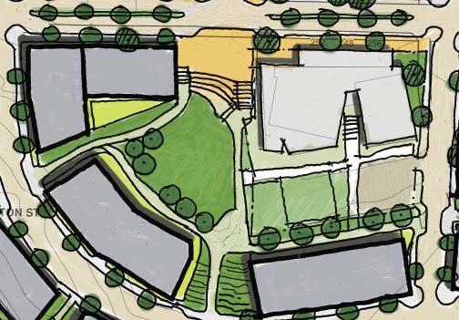
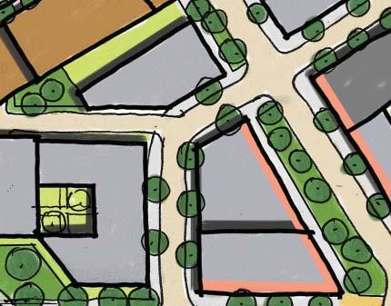
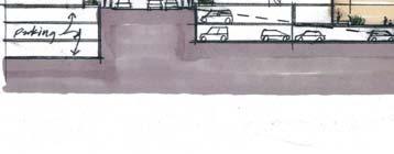
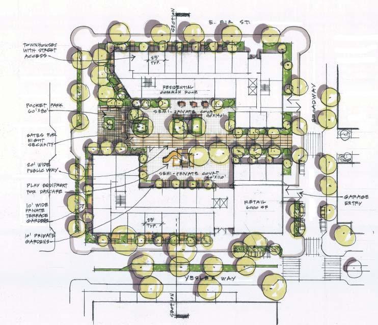
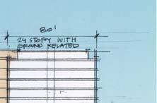
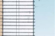
4 Concept A Concept Summary Concept A takes its inspiration from the many wonderful, walkable neighborhoods in Seattle. It begins with an extension of the Seattle street grid to reinforce the connection between existing neighborhoods. An open space system of Green Streets and adjacent Street Parks compliments the street grid. 3a Concept Variables A 1. Topography 1a. Existing topography to remain 2. Land Use - Retail 2a. Retail along Yesler Way & Broadway 3. Land Use - Office 3a. Single use offices (high-rise) Housing dominates a majority of the site with office uses limited to the northwest quadrant near Harborview and retail focused along streets at the intersection of Yesler Way and Broadway adjacent to the Yelser Community Center. View overlook 6a 6b 7a 2a 5a 6b 6a 4. Circulation 4a. Extend the existing city grid 4b. Strongest circulation along Broad way and Yesler Way 5. Open Space 5a. Linked to a network of green streets 5b. Hierarchy of public & semi-private parks related to streets Pedestrian hillclimb Micro commercial pavilions Public plaza Green belt 5a 6a 1a 4a 6b 6a 5b 6. Building Height & Massing 6a. Uniform throughout the site 6b. Building heights range from Connections & Edges 7a. Community heart at Yesler Way & Broadway Potential bridge over I-5 Semi-private courtyard over parking Extend Broadway to the southern portion of Yesler Terrace Housing (high-rise) Housing (mid-rise) Public open space connects with green belt Street node viewpoint Pedestrian hill-climb


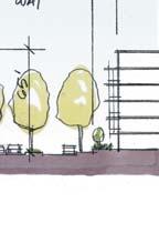
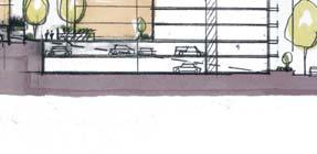
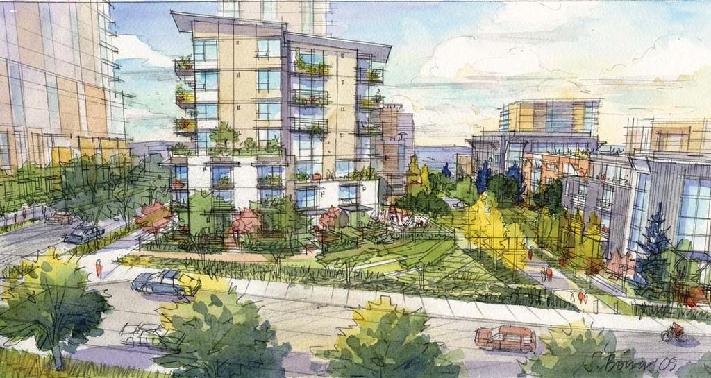
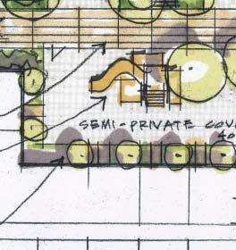
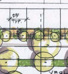
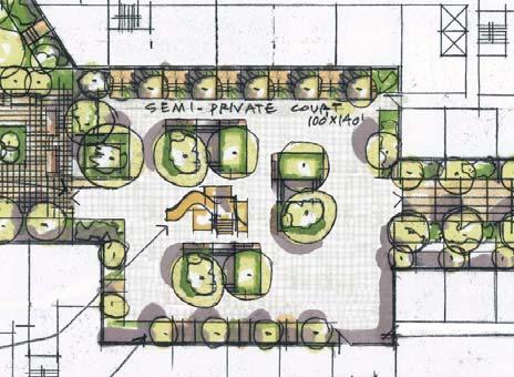
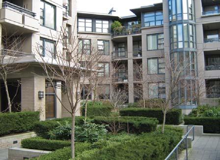
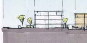
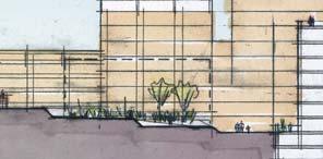
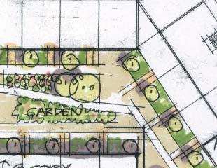
5 Concept A Housing Typologies & Character Sidewalk Landscaping Private patio & landscaping Alternative to courtyard shown; no secondary street access. Example of unit entry Ground-level units at courtyard Private landscaping Elevated porch Public sidewalk Green belt Site Plan Example of a semi-private courtyard. Example of unit entry Ground-level units on green belt Site Section Semi-Private Court Perspective View Stephanie Bower, Architectural Illustration


6 Concept A Topography Land Use - Office Depends the least resources on moving dirt Allows for easy phasing of south portion of YT HARBORVIEW SECTION YESLER WAY LITTLE SAIGON Locates bulk of office uses in area of known demand HARBORVIEW MARKET Relies on other strategies, like circulation network, to integrate the south portion of YT EXISTING GRADE YESLER WAY EXISTING GRADE Fosters less integration throughout the rest of Yesler Terrace Existing topography to remain Office in northwest quadrant Land Use - Retail Circulation Enhances a vibrant heart in the center of Yesler Terrace Builds on the existing customer traffic of Yesler and Broadway Does not reach out to adjacent neighborhoods as much as other strategies Provides weak connection to Little Saigon and International District Creates traditional Seattle neighborhood feeling through block sizes and street network Integrates by using existing urban street grid Creates parcel sizes familiar to developers Allows for ease of project phasing Enhances east-west view opportunities Takes advantage of shallow grades in E/W direction Expends more resources to streets - needs to be balanced by adding value through other strategies Extend the existing street network Retail at Yesler & Broadway Small retail along the street Open air market adjacent to housing Active streets Residential streets


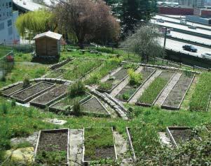
7 Concept A Open Space Building Height & Massing Provides direct connection and overlap between open space and circulation network Infuses landscaping throughout car and pedestrian spaces Provides for easy extension into adjacent neighborhoods GREEN BELT ALONG STREET PUBLIC PARKS ADJACENT TO STREETS SEMI-PRIVATE COURTS GREEN STREET Treats all areas of Yesler Terrace equally Keeps residents close to street life and open space Moderate construction cost Allows housing types to be integrated throughout YT Casts shorter shadows than high rise Spreads real estate value evenly across site Allocates a higher proportion of open space to linear green streets than parks Provides smaller range of open space sizes Parks on green streets Generates fewer high-view, high-value units Creates single moderate-cost development model A range of heights; evenly distributed; max Public plaza Connections/Edges Public park adjacent to street Focuses on creating a vibrant heart in the center of Yesler Terrace that draws other neighborhoods in Builds on the existing assets of Yesler and Broadway Does not reach out to adjacent neighborhoods as much as other strategies Semi-private courtyard Strengthen the community heart at Yesler & Broadway

8 Concept B Concept Summary Concept Variables One of the ideas for this concepts envisions Yesler Terrace being part of a larger Yesler neighborhood which could extend from I-5 to 19th Avenue East. The center for this new neighborhood would be located at the Boren, Yesler Way, and 12th Avenue East adjacent to the planned street car location on Boren. 6a 1. Topography 1a. Fill site south of Yesler Way 2. Land Use - Retail 2a. Commercial retail center at Boren 2b. Mini-retail at Broadway & Yesler A second idea centers around creating green public open spaces independent of the street network. The secondary open space system would link public parks independent of the streets providing an alternative circulation pathway through the site. Adjacent to Harborview and along Boren Avenue where building height and massing would be higher providing the opportunity for less building height and massing southwest of the conmmunity center. 3a 5a 6b 2b 6a 5a 3b 7a 6a 2a 3. Land Use - Office 3a. Single use offices (high-rise) 3b. Mixed use & mid-rise offices 4. Circulation 4a. Unique circulation pattern 4b. Strongest circulation along Boren and Yesler Way 5. Open Space 5a. Linked together away from streets 5b. Small parks independent of network Housing (250 towers) Semi-private open space Potential pedestrian lid over I-5 Large community park Community pea patch gardens 1a 6b 4a 5a 5b 6. Building Height & Massing 6a. High at Harborview & along Boren 6b. Low southwest of Broadway/Yesler Way 7. Connections & Edges 7a. Create a larger Yesler neighborhood (centered at Yesler Way & Boren) Pedestrian hillclimb to Little Saigon and the International District Proposed street car line Pedestrian connection to Little Saigon


9 Concept B Housing Typologies & Character Private unit entry at court Courtyard private unit entry Ground-level units at courtyard Alternate plan of semi-private courtyard. (no public access) Private unit porch entry at street Street private unit entry Ground-level units on Yesler Way Site Plan Alternate semi-private courtyard. Site Section Interior Park Perspective View Stephanie Bower, Architectural Illustration


 demand Begins to integrate office into other areas of")


10 Concept B Topography Land Use - Office Provides for strongest integration of the south and north portions of YT Creates relatively level building sites in southern site Requires significant cost for regrading - will need to be balanced by added value Provides least ability to retain existing trees in south portion Makes connection of Yesler Terrace to Little Saigon more difficult Requires the south portion of YT be constructed in one phase HARBORVIEW YESLER WAY LITTLE SAIGON SECTION EXISTING GRADE YESLER WAY FILL Fill south of Yesler Way to create a plateau Locates office use in locations of known (Harborview) and strong potential (Yesler and Boren) demand Begins to integrate office into other areas of Yesler Terrace Office demand at Yesler & Boren may take time to develop HARBORVIEW MARKET YESLER & BOREN MARKET Office near Harborview and along Boren Land Use - Retail Focuses on expanding the boundaries of Yesler Terrace Builds on existing assets of Yesler and Boren, and proposed asset of First Hill street car line Risks reducing the heart of Yesler Terrace at the intersection of Broadway and Yesler Way Retail on both Yesler and Boren Circulation Creates integration into the community by using existing urban street grid Allows for ease of project phasing Enhances north-south view opportunities Creates parcel sizes familiar to developers Fights steep slopes in north-south direction Create a street network unique to Yesler Terrace


 Steps height down")


11 Concept B Open Space Building Height & Massing Provides more open space without cars Allocates most open space in parks of varying size Provides indirect connection between open space and circulation network Does not lend itself to extension into adjacent neighborhoods Off-street parks and green links STREET HIERARCHY OFF-STREET PARK PUBLIC OPEN SPACE Locates tallest new Yesler Terrace buildings near tallest existing off-site buildings (i.e. Harborview) Steps height down across the site for best access to views and solar exposure Creates a variety of development models; some higher cost and some lower cost Casts long shadows on neighborhoods to north and east Spreads real estate value unevenly across site Suggests segregation of different housing types in different areas Greatest heights along Harborview and Boren Connections/Edges Site plan location of off-street parks & green links network Focuses on expanding the boundaries of Yesler Terrace Builds on existing assets of Yesler and Boren, and proposed asset of First Hill street car line Strengthens both north-south and east-west neighborhood connections Creating two hearts, one at Yesler Community Center and another on the edge and downhill from Yesler Terrace Expand Yesler Terrace neighborhood
12 Concept C Concept Summary Concept Variables C Connections are strong from Harborview to Little Saigon and touch most of the adjacent districts. Circulation parallels I-5 and Boren and strengthens the main north/south connection at the 9th to 10th Ave hillclimbs. 1. Topography 1a. Cut site south of Yesler Way 2. Land Use - Retail Open space includes the Hillclimb Spine of Parks and the widened 9th Ave/10th Avenue connector from Harborview to Little Saigon. Additional open space is in district parks or semi-public open spaces. District open spaces with a feeling of openness above are created by mixing lowrises, midrises and towers. More Three-story ground related units can be made available for daycare, senior/accessible units and market rate housing adjacent to social services and amenities. Retail and office placement reinforce the Connections, Circulation, Open Spaces and Heights and Massing. North/south connector; Hillclimb spine of parks connects Harborview to Little Saigon Retail (typical) Office tower (typical) 3b 3c 3a 5a 2a 5b 4b 2a 4a 2a 7a 6b 5a 3a 5b 3b 2a. Retail northwest of Yesler Way & Broadway 3. Land Use - Office 3a. Single use offices (towers) 3b. Mixed-use offices (mid-rise) 3c. Single use offices (low-rise) 4. Circulation 4a. Create a strong connection between Harborview & Little Saigon 4b. Strongest circulation along Yesler Way and 9th Avenue 5. Open Space 5a. NE/SW spine of parks 5b. Unique parks for individual districts 6. Building Height & Massing 6a. Uniform throughout the site 6b. Tall buildings (250 ) evenly spaced between height buildings Residential tower (typical) Mid-size community park District open space (typical) 7. Connections & Edges 7a. Community heart between the Com munity Center and Harborview


13 Concept C Housing Typologies & Character Community garden Private patio Private patio Elevated porch Garden unit Example of day care unit Day care unit possibilities Elevated porch Site Plan Private entry at street facing unit Street facing unit Private landscape Garden unit connection to public open space Site Section District Park Perspective View Stephanie Bower, Architectural Illustration


14 Concept C Topography Land Use - Office Provides for the strongest connection of Yesler Terrace with Little Saigon Requires additional cost for regrading Makes phased development difficult EXISTING GRADE CUT HARBORVIEW YESLER WAY SECTION YESLER WAY LITTLE SAIGON Affords most integration of office use throughout Yesler Terrace Allows greater use of distributed office parking across the site Creates fragmented locations not near existing or potential demand, which may not be economically sustainable HARBORVIEW MARKET I-5 MARKET YESLER & BOREN MARKET LITTLE SAIGON MARKET Cut south of Yesler Way to connect with Little Saigon Office around the perimeter of the site Land Use - Retail Enhances a vibrant heart in the center of Yesler Terrace Builds on the existing customer traffic of Yesler and Broadway Does not reach out to adjacent neighborhoods as much as other strategies Provides weak connection to Little Saigon and International District Retail northwest of Yesler Way & Broadway Circulation Builds on parallel nature of I-5 and Boren Achieves adequate site access with minimum of roads Creates large development parcels - may need to be broken down using other strategies Core axes with residential loop


15 Concept C Open Space Building Height & Massing Creates strong sense of central heart in YT Allocates most open space in parks of varying size Provides indirect connection between open space and circulation network Does not lend itself to extension into adjacent neighborhoods Parks in each district RESIDENTIAL DISTRICTS PUBLIC OPEN SPACE Treats all areas of Yesler Terrace equally Spreads real estate value types evenly across site Allows housing types to be integrated throughout YT Allows lower densities in low- and mid-rise buildings Allows greater open space options Creates separation between residents in high rises and street life Entails higher construction cost Casts long shadows on and off site Creates single high-cost development model Higher and lower; evenly distributed. Connections/Edges Strengthens north-south neighborhood connections Tries to establish a connection across a long distance and big grade change - which may have challenges Reach out to Harborview and Little Saigon
16 EVALUATION CRITERIA Rate how well each concept satisfies the criteria for the project. In each of the GOLD boxes place a number between 1 and 5. 1 = least support of the criteria 5 = most support of the criteria CONCEPT A CONCEPT B CONCEPT C 1. TOPOGRAPHY: Which approach to regrading the southern portion of the site improves the future Yesler Terrace? (GP 3, 4, 22, 33; PC 4, 7) Topography creates strong connections to surrounding neighborhoods. Topography creates strong connections within Yesler Terrace. View opportunities are preserved and enhanced. TOPOGRAPHY AVERAGE SCORE: LAND USE RETAIL: Which locations for retail improves the future Yesler Terrace? (GP 1, 3, 4, 17, 19, 20, 22, 28; PC 5, 6, 7) Retail locations create strong connections to surrounding neighborhoods Retail locations create strong connections within Yesler Terrace Provide effective locations for small and micro businesses. LAND USE RETAIL AVERAGE SCORE: LAND USE OFFICE: Which locations for office improves the future Yesler Terrace? (GP 1, 19, 20, 22, 28; PC 1, 5, 6, 7) Office locations create strong connections to surrounding neighborhoods Office locations provide an integrated mix of land uses. Office locations are economically sustainable. (This will be evaluated at a later time) Project phasing accommodates reasonable parcel sizes and economic cycles. (This will be evaluated at a later time) LAND USE OFFICE AVERAGE SCORE: CIRCULATION: Which circulation pattern improves the future Yesler Terrace? (GP 3, 4, 19, 20, 22, 33; PC 2, 3, 4, 7) Circulation patterns create a walkable neighborhood. Circulation strengthens Broadway as a primary north south vehicular and pedestrian corridor Circulation strengthens Yesler Way as a primary east west vehicular and pedestrian corridor The street grid integrates Yesler Terrace with the surrounding community. Views are preserved and enhanced from the public rights of ways. CIRCULATION AVERAGE SCORE: OPEN SPACE: Which open space approach improves the future Yesler Terrace? (GP 1, 4, 9, 20, 21, 22, 25, 27, 33; PC 1, 7, 8) A variety of multiple use open space sizes are provided to support a diversity of needs. Include provisions for community gatherings and celebrations. Use urban gardens as activity centers to promote community building. Uses and activities around the intersection of Yesler and Broadway complements the Community Center and creates a dense urban node. Open spaces are connected to the circulation network. There is a clear hierarchy of overlapping public and private open spaces and buildings. Views are preserved and enhanced from public open spaces. OPEN SPACE AVERAGE SCORE: 0 0 0
17 EVALUATION CRITERIA Rate how well each concept satisfies the criteria for the project. In each of the GOLD boxes place a number between 1 and 5. 1 = least support of the criteria 5 = most support of the criteria CONCEPT A CONCEPT B CONCEPT C 6. HEIGHT / MASSING: Which Height / Massing approach improves the future Yesler Terrace? (GP 1, 4, 17, 19, 20, 21, 22, 27, 28; PC 1, 5, 6, 7) Building heights and massing creates strong connections to surrounding neighborhoods. Building heights and massing creates strong connections within Yesler Terrace. Views are preserved and enhanced from buildings. Views are preserved and enhanced between buildings. Building locations and types provides a range of housing opportunities and choices. Building locations and types enhance neighborhood character and optimizes access to sunlight for housing and open spaces. 7. CONNECTIONS / EDGES: Which approach better connects Yesler Terrace to adjacent neighborhoods? (GP 3, 4, 19, 20, 22, 27, 28; PC 2, 3, 4, 5, 6, 7) Rank Neighborhood Connections by Levels of Importance (1 for most important, 4 for least important) HEIGHT / MASSING AVERAGE SCORE: o North (Harborview Hospital) o South (Little Saigon and International District) o East (12th Avenue and Squire Park) o West (Downtown) Evaluate Quality / Strength of Connections from Yesler Terrace: North (Harborview Hospital) South (Little Saigon and International District) East (12th Avenue and Squire Park) West (Downtown) N= E= S= W= Community gateways are highlighted. 8. COMMENTS: Please provide comments that will help improve the concepts. CONNECTIONS / EDGES AVERAGE SCORE: CONCEPT AVERAGE SCORE:
Yesler Terrace Explorations of Ideas 11 March 2009
 Yesler Terrace Explorations of Ideas 11 March 2009 Exploration of Ideas for Yesler Terrace Where are we in the process? Testing the Yesler Terrace Planning Program 1) How does the new Yesler Terrace feel?
The University District envisions, in its neighborhood
 Envisioning the University District Link Light Rail in Seattle s neighborhoods CIY OF SEALE CONCEP-LEVEL SAION AREA PLANNING RECOMMENDAION RESOLUION # 30165 EXHIBI L Vision 08.2000 he University District
Create Policy Options Draft Plan Plan Approval. Public Consultation Events. Phase 2
 Background Grandview-Woodland Community Plan In the spring of 2012, the City of Vancouver embarked on a comprehensive community planning program in the Grandview-Woodland neighbourhood. The process has
Policies and Code Intent Sections Related to Town Center
 Policies and Code Intent Sections Related to Town Center The Town Center Vision is scattered throughout the Comprehensive Plan, development code and the 1994 Town Center Plan. What follows are sections
EXISTING COMPREHENSIVE PLAN
 EXISTING COMPREHENSIVE PLAN Town Center Land Use Element: V. LAND USE POLICIES Town Center Mercer Island's business district vision as described in "Your Mercer Island Citizen-Designed Downtown" was an
BROOKLYN PARK / 85TH AVE LRT STATION CDI DEVELOPMENT GUIDELINES DRAFT
 August 2018 Page intentionally left blank The Brooklyn Park Library adjacent to the 85th Ave LRT Station Area. OVERVIEW The Blue Line LRT Extension / Bottineau corridor offers a unique opportunity to leverage
Description of Preferred Alternative
 Chapter 2 Description of Preferred Alternative 2.1 Introduction This chapter of the programmatic Sammamish Town Center Sub-area Plan Final EIS provides a more detailed description of the Preferred Alternative
burlington mobility hubs study Downtown Burlington Mobility Hub
 burlington mobility hubs study Downtown Burlington Mobility Hub Draft Precinct Plan Workbook PIC #3, September 7, 2017 downtown mobility hub objectives City staff and their consultants are proposing an
Forest Hills Improvement Initiative A Partnership for Building a Better Community. Use & Design Guidelines September 23, 2008
 Forest Hills Improvement Initiative A Partnership for Building a Better Community City of Boston Thomas M. Menino, Mayor Emerging Community Vision p. 2 Site Use & Design Guidelines p. 3 to 21 Arborway
Transportation. Strategies for Action
 Transportation A major priority for the Overlake Neighborhood is to develop a multimodal transportation system. To achieve this system, a balance has to be found among travel, circulation and access needs;
Little Mountain UDP Presentation
 Summary of UDP Evaluation of Dec 2015 Plan Dec 2015 Site Plan Transitional edges work well Central spine and permeability are strong Tree retention is good Establish Big Idea Sameness of built form contributes
Ivywild On The Creek PRELIMINARY CREEK DISTRICT MASTER PLAN
 Ivywild On The Creek PRELIMINARY CREEK DISTRICT MASTER PLAN Introduction: Rejuvenating an extraordinary Creekside neighborhood THE CREEKSIDE DISTRICT The Ivywild On The Creek Neighborhood District Master
This Review Is Divided Into Two Phases:
 Semiahmoo Town Centre Review The purpose of this review: To review the Semiahmoo Town Centre Concept Plan, originally approved in 1993, to ensure that this centre will continue to serve the needs of South
[PLANNING RATIONALE] For Site Plan Control and Lifting of Holding Zone By-Law 101 Champagne Avenue. May 23, 2014
![[PLANNING RATIONALE] For Site Plan Control and Lifting of Holding Zone By-Law 101 Champagne Avenue. May 23, 2014](/thumbs/75/71599615.jpg "[PLANNING RATIONALE] For Site Plan Control and Lifting of Holding Zone By-Law 101 Champagne Avenue. May 23, 2014") [PLANNING RATIONALE] For Site Plan Control and Lifting of Holding Zone By-Law 101 Champagne Avenue May 23, 2014 Contents 1.0 Introduction... 2 2.0 Site Context... 2 2.1 Adjacent Uses... 2 Figure 1: Site
[PLANNING RATIONALE] For Site Plan Control and Lifting of Holding Zone By-Law 101 Champagne Avenue May 23, 2014 Contents 1.0 Introduction... 2 2.0 Site Context... 2 2.1 Adjacent Uses... 2 Figure 1: Site
Corridor Vision. 1Pursue Minnehaha-Hiawatha Community Works Project. Mission of Hennepin County Community Works Program
 1Pursue Minnehaha-Hiawatha Community Works Project Minnehaha-Hiawatha Community Works is a project within the Hennepin Community Works (HCW) program. The mission of the HCW program is to enhance how the
IMAGINE CLEARWATER. Community Workshop 3. November 2016
 IMAGINE CLEARWATER Community Workshop 3 November 2016 Imagine Clearwater has been a 6-month community-focused process to re-envision the downtown waterfront. VISIONING FRAMEWORK MASTER PLAN HOW CAN WE
2.0 THE PLATINUM TRIANGLE VISION
 2.0 THE PLATINUM TRIANGLE VISION The envisions an exciting future for the area surrounding Angel Stadium of Anaheim, the Honda Center and The Grove of Anaheim. 2.1 Planning Principles In order to further
DRAFT Land Use Chapter
 Stevens Creek Urban Village DRAFT 1 18 17 Land Use Chapter INTRODUCTION This Land Use Chapter describes how the Stevens Creek Urban Village will accommodate the growth that is planned for it in the Envision
Clairtrell Area Context Plan
 Clairtrell Area Context Plan March 2005 Urban Development Services City Planning Contents 1. Introduction... 4 2. Development Structure... 6 2.1 Streets... 7 2.1.1 Sheppard Avenue and Bayview Avenue...
Midtown Greenway Land Use and Development Plan Executive Summary
 Midtown Greenway Land Use and Development Plan Executive Summary Introduction The Midtown Greenway Land Use and Development Plan sets policy direction for land use and development in the Midtown Greenway
THE NEIGHBORHOOD TODAY
 THE NEIGHBORHOOD TODAY CORE AREA VISION How are we Good Urbanism A Site s DNA thinking about Elements of great Unique elements urban communities embedded in a place the site and design? ELEMENTS LIKE:
DOWNTOWN RESIDENTIAL DISTRICT DEVELOPMENT OPPORTUNITES
 DOWNTOWN RESIDENTIAL DISTRICT DEVELOPMENT OPPORTUNITES Out of all the areas in Downtown Painesville, this district provides the greatest opportunity for change with the vacation of Lake East Hospital.
Planning Concepts. Working Toward a Community Vision
 Working Toward a Community Vision Yesler Terrace Redevelopment Project Citizen Review Committee November 2007 Dear Seattle Housing Authority Board of Commissioners, Residents and Community Stakeholders,
Workshop 3. City of Burlington Waterfront Hotel Planning Study. September 14, The Planning Partnership
 Workshop 3 City of Burlington Waterfront Hotel Planning Study September 14, 2017 The Planning Partnership The Waterfront Hotel Planning Study 01 The Brant & Lakeshore Planning Study will establish a Strategic
PLAN ELEMENTS WORKSHOP. April 5, 2016
 PLAN ELEMENTS WORKSHOP April 5, 2016 needs more housing. But there is no one-size fits-all solution. Every neighborhood has its own character. In some places, density is not only appropriate it is badly
THE POLICY FRAMEWORK FOR WALKABLE COMMUNITIES. Community Technical Assistance Program Building Active Communities Institute March 2016
 THE POLICY FRAMEWORK FOR WALKABLE COMMUNITIES Community Technical Assistance Program Building Active Communities Institute March 2016 ACTIVE COMMUNITIES BACK THEN ACTIVE COMMUNITIES BACK THEN Lifestyle
CRYSTAL CITY BLOCK PLAN # CCBP- G 1 DRAFT
 CRYSTAL CITY BLOCK PLAN # CCBP- G 1 DRAFT BLOCK G (Metro Market Square block) Long Range Planning Committee Meeting January 29, 2018 1 1. Introduction 2 1. LRPC Meeting Purpose Review of proposed Crystal
New-Cast Mixed-use Development Proposal King Street West, Newcastle, Ontario
 URBAN DESIGN BRIEF New-Cast Mixed-use Development Proposal King Street West, Newcastle, Ontario TABLE OF CONTENTS: 1.0 Executive Summary 2.0 Creating Vibrant and Sustainable Urban Places: Excerpts from
Town Center (part of the Comprehensive Plan)
") Town Center (part of the Comprehensive Plan) Mercer Island Town Center Looking North (2014) In 1994, a year-long process culminated in a set of design guidelines and code requirements for the Town Center
Town Center (part of the Comprehensive Plan) Mercer Island Town Center Looking North (2014) In 1994, a year-long process culminated in a set of design guidelines and code requirements for the Town Center
WEST LOOP DESIGN GUIDELINES CHECKLIST
 WEST LOOP DESIGN GUIDELINES CHECKLIST Section 1.0 General Strategies 1.1 DESIGN EXCELLENCE: ENCOURAGE HIGH QUALITY AND INNOVATIVE DESIGN OF NEW BUILDINGS WITHIN THE WEST LOOP WITHOUT BEING PRESCRIPTIVE
Courthouse Square Planning & Urban Design Study. Courthouse Square Working Group #13 October 15, 2014
 Courthouse Square Planning & Urban Design Study Courthouse Square Working Group #13 October 15, 2014 1 Courthouse Square Process Working Group Community Courthouse Square Advisory Groups & Civic Associations
Allen Street Civic District Redevelopment Area Plan Redevelopment Plan & Proposal State College Planning Commission State College Redevelopment
 Allen Street Civic District Redevelopment Area Plan Redevelopment Plan & Proposal State College Planning Commission State College Redevelopment Authority September 17, 2015 Discussion Points Overview of
University of Saskatchewan CAMPUS MASTER PLAN. Senate Meeting Preliminary Presentation. April 21, 2018 DIALOG ECS DA WATT
 University of Saskatchewan CAMPUS MASTER PLAN Senate Meeting Preliminary Presentation April 21, 2018 DIALOG ECS DA WATT project process presentation agenda Stakeholder Engagement Project Control phase1
hermitage town center
 hermitage town center A Community Vision prepared by Strada for The City of Hermitage and The Mercer County Regional Planning Commission January 2007 table of contents introduction 3 design principles
Urban Design Manual PLANNING AROUND RAPID TRANSIT STATIONS (PARTS) Introduction. Station Study Areas
 Introduction. Station Study Areas") 111111 PLANNING AROUND RAPID TRANSIT STATIONS (PARTS) Introduction The ION rapid transit system will link Waterloo, Kitchener and Cambridge through a central transit corridor (CTC). There are a number
111111 PLANNING AROUND RAPID TRANSIT STATIONS (PARTS) Introduction The ION rapid transit system will link Waterloo, Kitchener and Cambridge through a central transit corridor (CTC). There are a number
ELMVALE ACRES SHOPPING CENTRE MASTER PLAN
 ELMVALE ACRES SHOPPING CENTRE MASTER PLAN Contents 1.0 INTRODUCTION... 2 2.0 LOCATION... 2 3.0 EXISTING CONTEXT... 2 4.0 VISION & GUIDING PRINCIPLES... 2 5.0 LAND USE AND BUILT FORM... 4 5.1 St. Laurent
Walnut Creek BART Station
 Walnut Creek BART Station Mixed Use Transit Oriented Project Design Review Commission Study Session May 17, 2006 Applicant: Walnut Creek Transit Lifestyles Associates Joint Venture: Transit Village Associates
Gold Line Bus Rapid Transit Transit Oriented Development (BRTOD) Helmo Station Area Plan
 Helmo Station Area Plan") Appendix F Gold Line Bus Rapid Transit Transit Oriented Development (BRTOD) Helmo Station Area Plan Introduction and Purpose of the Plan The Gold Line Bus Rapid Transit facility is an eleven-mile dedicated
Appendix F Gold Line Bus Rapid Transit Transit Oriented Development (BRTOD) Helmo Station Area Plan Introduction and Purpose of the Plan The Gold Line Bus Rapid Transit facility is an eleven-mile dedicated
AMITY STATION Revised Concept Plan Review West Rosemary Street Chapel Hill, NC September 27, 2016
 AMITY STATION Revised Concept Plan Review West Rosemary Street Chapel Hill, NC September 27, 2016 DEVELOPER'S PROGRAM Introduction This is a request for review of a Revised Concept Plan by Chapel Hill
WEST OAKLAND SPECIFIC PLAN Final Plan. 2. Vision & Goals. 2.1 Community-Based Goals and Objectives
 WEST OAKLAND SPECIFIC PLAN Final Plan 2. Vision & Goals 2.1 Community-Based Goals and Objectives June 2014 2: Vision & Goals The vision of the West Oakland Specific Plan is to see this remarkable community
FUTURE LAND USE ELEMENT
 FUTURE LAND USE ELEMENT GOAL I: To create and sustain a great place to live, play, and prosper Objective 1: The City of Ocala shall incorporate the principles and strategies of the Ocala 2035 Vision into
CITY OF FARGO PARKING RAMP SITE EVALUATION
 CITY OF FARGO PARKING RAMP SITE EVALUATION EXECUTIVE SUMMARY Helenske Design Group (architect) and Carl Walker Inc (Parking Consultant) were retained by the City of Fargo to complete a downtown parking
Welcome to the Oakridge Centre Open House
 Welcome to the Oakridge Centre Open House Why is the City hosting this event? This open house is to inform you of a rezoning application submitted to the City of Vancouver to amend the existing CD-1 (Comprehensive
Sustainability, Health, Safety, Recreation & Open Space Working Group August 3, 2017
 Sustainability, Health, Safety, Recreation & Open Space Working Group August 3, 2017 DOWNTOWN OAKLAND SPECIFIC PLAN WELCOME Sustainability, Health, Safety, Recreation & Open Space Working Group Social
Official Plan Review: Draft Built Form Policies
 PG.30.1 REPORT FOR ACTION Official Plan Review: Draft Built Form Policies Date: May 15, 2018 To: Planning and Growth Management Committee From: Chief Planner and Executive Director, City Planning Division
Public Open House. Yonge Street and Bernard Avenue (Bernard KDA) Planning Study Update Town of Richmond Hill. March 30, 2017
 Planning Study Update Town of Richmond Hill. March 30, 2017") Public Open House Yonge Street and Bernard Avenue (Bernard KDA) Planning Study Update Town of Richmond Hill March 30, 2017 Open House Review of Project Purpose and Process Policy Refresher Highlights of
Public Open House Yonge Street and Bernard Avenue (Bernard KDA) Planning Study Update Town of Richmond Hill March 30, 2017 Open House Review of Project Purpose and Process Policy Refresher Highlights of
11 GUIDING PRINCIPLES:
 11 GUIDING PRINCIPLES: CATEGORIES FIVE GUIDING PRINCIPLE CATEGORIES The Policy Statement will contain a set of Guiding Principles to inform the urban design and sustainability objectives for the site.
Community Design Guidelines. Port Wallace DRAFT
 Community Design Guidelines Port Wallace DRAFT Energy 1 2 3 Nature Movement Connections Built Form DRAFT Layout Energy 1 Nature Community Design Guidelines GREAT COMMUNITIES PROTECT, CELEBRATE, AND CONSERVE
BROOKHILL NEIGHBORHOOD MODEL ZONING MAP AMENDMENT PREFACE TO APPLICATION
 BROOKHILL NEIGHBORHOOD MODEL ZONING MAP AMENDMENT PREFACE TO APPLICATION June 15, 2015 Revised: August 1, 2016 I. VISION Brookhill is a proposed community based upon the principles of Albemarle County
City of Farmington. Downtown Plan. Amendment to the 1998 Master Plan Adopted October 11, 2004
 City of Farmington Amendment to the 1998 Master Plan Adopted October 11, 2004 Introduction Planning Background 1 Scope and Components of the Plan Amendment 2 Concept Introduction 3 Plan Concepts 3 Conceptual
Vision & Land Use. Discussion. Historic Preservation Plan. Foggy Bottom Campus Plan:
 Vision & Land Use Foggy Bottom Campus Plan: 2006-2025 Historic Preservation Plan Discussion Community Meeting Presentation August 2, 2006 Presentation Format Overview Sherry Rutherford, GW Foggy Bottom
Gas Works Site Land-Use Study
 City of New Westminster Background Context 2 Neighbourhood Context 3 Program Elements 4 Proposed Site Planning Approach 5 Design Rationale 10 Design Elements 11 Phasing 21 C o n t e n t s b a c k g r o
POLICY AMENDMENT AND LAND USE AMENDMENT TUXEDO PARK (WARD 9) CENTRE STREET N AND 26 AVENUE NE BYLAWS 36P2017 AND 234D2017
 CENTRE STREET N AND 26 AVENUE NE BYLAWS 36P2017 AND 234D2017") Page 1 of 11 EXECUTIVE SUMMARY This application proposes to redesignate a single parcel of land in the Community of Tuxedo Park from Commercial Corridor 2 (C-COR2 f1h10) District to Mixed Use Active Frontage
Page 1 of 11 EXECUTIVE SUMMARY This application proposes to redesignate a single parcel of land in the Community of Tuxedo Park from Commercial Corridor 2 (C-COR2 f1h10) District to Mixed Use Active Frontage
Subdivision Design Criteria. Penihana North GUIDELINES TO THE RULES
 Created September 2013 Penihana North Subdivision Design Criteria GUIDELINES TO THE RULES This part of the Plan sets out the design criteria for subdivision in Penihana North. The criteria will be considered
Preliminary Plan Framework: Vision and Goals
 Preliminary Plan Framework: Vision and Goals Draft: May 2015 Introduction Since the Town of Milliken s comprehensive plan was last updated in 2010, the community was heavily impacted by the 2013 flood,
Streets, Connectivity & Built Environment Working Group August 2, 2017
 Streets, Connectivity & Built Environment Working Group August 2, 2017 DOWNTOWN OAKLAND SPECIFIC PLAN WELCOME Streets, Connectivity & Built Environment Working Group Social Equity Meeting August 2, 2017
Community Design Plan
 Gardena General Plan 2006 Authority While the is not a required element of a General Plan, it is included because improving the community appearance and image is paramount to the overall quality of life
REZONING GUIDE. Zone Map Amendment (Rezoning) - Application. Rezoning Application Page 1 of 3. Return completed form to
 - Application. Rezoning Application Page 1 of 3. Return completed form to") Zone Map Amendment (Rezoning) - Application COMMUNITY PLANNING & DEVELOPMENT REZONING GUIDE Rezoning Application Page 1 of 3 PROPERTY OWNER INFORMATION* CHECK IF POINT OF CONTACT FOR APPLICATION Property
Zone Map Amendment (Rezoning) - Application COMMUNITY PLANNING & DEVELOPMENT REZONING GUIDE Rezoning Application Page 1 of 3 PROPERTY OWNER INFORMATION* CHECK IF POINT OF CONTACT FOR APPLICATION Property
Subarea 4 Indian Creek. Vision The combination of park networks and transportation amenities make Subarea 4 the greenest hub in the Corridor.
 indian creek 180 extends south from 101st Street to I-435. The I-435 and Metcalf intersection is one of the primary intersections in the Kansas City Metro Area. The area includes several residential neighborhoods
Atlanta BeltLine. Subareas 9 & 10. Master Plan Updates. March 26, Washington Park Jamboree 1
 Atlanta BeltLine Subareas 9 & 10 Master Plan Updates March 26, 2018 Washington Park Jamboree 1 22 miles, connecting 45 neighborhoods 22 MILES of transit 46 MILES of streetscapes and complete streets 33
New Partners for Smart Growth Conference February 5, 2010
 Dan Stroh, Planning Director City of Bellevue Planning and Community Development Bellevue, WA New Partners for Smart Growth Conference February 5, 2010 Summary of Project Long-range plan update for Bel-Red
WHAT WE HEARD REPORT - Summary Bonnie Doon Mall Redevelopment Application (LDA )
") WHAT WE HEARD REPORT - Summary Bonnie Doon Mall Redevelopment Application (LDA18-0184) PROJECT ADDRESS: 1 Bonnie Doon Shopping Centre NW, 8420 85 Street NW & 8715 85 Street NW PROJECT DESCRIPTION: Rezoning
WHAT WE HEARD REPORT - Summary Bonnie Doon Mall Redevelopment Application (LDA18-0184) PROJECT ADDRESS: 1 Bonnie Doon Shopping Centre NW, 8420 85 Street NW & 8715 85 Street NW PROJECT DESCRIPTION: Rezoning
Vancouver Towers + Podiums. West End to Abu Dhabi
 Vancouver Towers + Podiums West End to Abu Dhabi What is the major issue that the City of Vancouver is dealing with in the next five to ten years? What is the City of Vancouver s Vision for growth? How
2. Form and Character. 2.1 Introduction. 2.2 The Downtown Addition Plan. 2.1 Introduction
 2.1 Introduction 2.1 Introduction This section of the Specific Plan describes and illustrates the desired form, character and uses of the Downtown Addition and explains the underlying design principles.
TABLE OF CONTENTS 1.0 INTRODUCTION... 3
 TABLE OF CONTENTS 1.0 INTRODUCTION... 3 1.1. BACKGROUND... 3 1.2. THE PROPOSAL... 5 2.0 EXISTING POLICY FRAMEWORK... 5 2.1. PROVINCIAL POLICY STATEMENT (PPS)... 5 2.2. CITY OF LONDON OFFICIAL PLAN (OP)...
Official Plan Review
 Official Plan Review Summary Report - The Built Environment August 2014 Part 1: Introduction Planning for a healthy, prosperous and sustainable community is an important goal for our municipality. From
MEMO 1. INTRODUCTION PURPOSE & PROCESS REQUEST
 MEMO Date: August 22, 2017 To: Board of Commissioners From: Jason Burdette, Planning Director Re: Davidson Commons East Hotel Stakeholder Feedback 1. INTRODUCTION PURPOSE & PROCESS This memorandum summarizes
East Central Area Plan
 East Central Area Plan Steering Committee Meeting March 8 th, 2018 CHUN Tears McFarlane House Vision Statement Development Opportunities Analysis Vision Elements 1. Equitable, Affordable and Inclusive
Concord Community Reuse Project Goals and Guiding Principles. Overarching Goals (OG)
") Concord Community Reuse Project Goals and Guiding Principles Overarching Goals (OG) No priority is implied by the order of presentation of the goals and guiding principles. Overarching goals for the Concord
Concord Community Reuse Project Goals and Guiding Principles Overarching Goals (OG) No priority is implied by the order of presentation of the goals and guiding principles. Overarching goals for the Concord
Complete Neighbourhood Guidelines Review Tool
 Complete Neighbourhood Guidelines Review Tool Prepared By: City of Regina Planning Department October 2014 Page 1 of 14 Community Development Review Checklist for Secondary Plans and Concept Plans The
Welcome. Walk Around. Talk to Us. Write Down Your Comments
 Welcome This is an information meeting introducing the applications for proposed redevelopment of the Yorkdale Shopping Centre site at 3401 Dufferin Street and 1 Yorkdale Road over the next 20+ years,
Chapter 4 - Master Plan
 MAUKA / EAST NORTH SOUTH CAMPUS Illustrative Plan MAKAI / WEST 39 Open Space Network & Parks Open space trails Armory Park in Lahaina Waipuilani Gulch Open space is essential to a healthy community. Successfully
LAND USE AMENDMENT DOWNTOWN COMMERCIAL CORE (WARD 7) MACLEOD TRAIL SE AND 5 AVENUE SE BYLAW 254D2017
 MACLEOD TRAIL SE AND 5 AVENUE SE BYLAW 254D2017") Page 1 of 10 EXECUTIVE SUMMARY This Land Use Amendment application seeks to redesignate a full downtown block (currently the YWCA site) from a Direct Control based on the CM-2 District (Land Use Bylaw
Page 1 of 10 EXECUTIVE SUMMARY This Land Use Amendment application seeks to redesignate a full downtown block (currently the YWCA site) from a Direct Control based on the CM-2 District (Land Use Bylaw
Rio/29 Small Area Plan. Design Plan & Implementation Framework Open House - January 25, 2018
 Rio/29 Small Area Plan Design Plan & Implementation Framework Open House - January 25, 2018 MEETING PURPOSE PRESENTATION 1. Orient to the updated design plans 2. Introduce implementing options 3. Explain
North Downtown Specific Plan MEMORANDUM
 North Downtown Specific Plan MEMORANDUM MEETING DATE: November 13, 2017 TO: Members of the North Downtown Specific Plan Advisory Committee FROM: Jeanine Cavalli, Senior Planner SUBJECT: Materials for the
greenprint midtown SUSTAINABILITY ACTION PLAN 2012
 greenprint midtown SUSTAINABILITY ACTION PLAN 2012 MIDTOWN ALLIANCE SOUTHFACE ENERGY INSTITUTE RENAISSANCE PLANNING GROUP SUSTAINABLE ATLANTA PERKINS+WILL 2 GREENPRINT MIDTOWN 1. Introduction Sustainability
Chapter 1: Introduction
 Chapter 1: Introduction The Penn Avenue Community Works Corridor Vision and Implementation Framework presents an integrated communitybased vision and a coordinated, long-term implementation framework for
B L A C K D I A M O N D D E S I G N G U I D E L I N E S for Multi-family Development
 B L A C K D I A M O N D D E S I G N G U I D E L I N E S for Multi-family Development Adopted June 18, 2009 This section of the Design and focuses on site planning and design guidance for new multi-family
Planning Board Briefing
 Planning Board Briefing Why Now? The Sector Plan Implementation Chapter States: Before Stage 1 begins, the following must occur: Approval of the Sectional Map Amendment. Approval of the Greater Lyttonsville
, C-MS I June 3, 2016 $1500 pd chk #216918
 , C-MS-8 LOTS 21 THROUGH 40, INCLUSIVE, BLOCK 299 CLEMENTS ADDITION TO THE CITY OF DENVER SOUTHEAST QUARTER OF SECTION 34, TOWNSHIP 3 SOUTH, RANGE 68 WEST, SIXTH PRINCIPAL MERIDIAN, CITY
3.1 Existing Land Use
 3.0 Land Use This strategy has been developed taking into account the position of the Town of Sidney as the economic center of the Saanich Peninsula. It acknowledges existing land use patterns in the downtown
Crofton Manor 2803 West 41st Avenue WHAT WE HEARD. Public Consultation: Phase 1
 Crofton Manor 2803 West 41st Avenue WHAT WE HEARD Public Consultation: Phase 1 Background CROFTON MANOR What s Happening The City of Vancouver is undertaking a planning and public engagement process to
Figure 3-1: Public Realm Plan
 3 Public Realm Figure 3-1: Public Realm Plan 3.1 Public Realm Concept The public realm concept for the Little Mountain site integrates a clear and accessible movement network with public spaces for social
3.1 community vision. 3.3 required plan elements
 Chapter 3 Community Form 3.1 community vision 3.2 Parks & landscaping concepts 3.3 required plan elements D R A F T 20 Community Form Chapter 3 3.0 Community form 3.1 community vision The Specific Plan
8. Urban Villages. Other Relevant Policies & Bylaws Official Community Plan Development Permit Area Designations and Guidelines
 8. Urban Villages Urban villages provide walkable shops and services, encourage a neighbourhood social life, create a sense of place and provide different housing options. More housing near Urban Villages
DRAFT. October Wheaton. Design Guidelines
 October 2011 DRAFT Wheaton Design Guidelines 2 Draft - Design Guidelines - Wheaton Sector Plan Contents 04 Section 1: Introduction 06 Section 2: Context 08 Section 3: Design Guidelines 09 Goal 1: Create
RE-Imagining the Downtown Colorado Springs Master Plan
 RE-Imagining the Downtown Colorado Springs Master Plan 2016 APA Colorado State Conference October 25, 2016 Overview 8:00 Welcome, Introductions, and Overview 8:15 Downtown s Planning History 8:30 A Market
ADMINISTRATION RECOMMENDATION(S) 2018 January 25. That Calgary Planning Commission recommend APPROVAL of the proposed Land Use Amendment.
 2018 January 25. That Calgary Planning Commission recommend APPROVAL of the proposed Land Use Amendment.") Page 1 of 9 EXECUTIVE SUMMARY This land use amendment proposes to redesignate a parcel from DC Direct Control District to Multi-Residential Contextual Grade-Oriented (M-CG) District to allow for multi-residential
Page 1 of 9 EXECUTIVE SUMMARY This land use amendment proposes to redesignate a parcel from DC Direct Control District to Multi-Residential Contextual Grade-Oriented (M-CG) District to allow for multi-residential
Urban Design Brief. Watson Parkway North & Watson Road North Guelph, Ontario. Prepared by Coletara Development
 Urban Design Brief Watson Parkway North & Watson Road North Guelph, Ontario Prepared by Coletara Development December, 2013 Urban Design Brief, Coletara Development 1 Introduction This Urban Design Brief
Robbinsdale LRT Station. CDI Development Guidelines. August Overview
 Robbinsdale LRT Station August 2018 Overview The City of Robbinsdale may have the coolest opportunity site along the 13 mile stretch of the Bottineau LRT corridor / Blue Line extension. Located a block
FRUITVALE TRANSIT VILLAGE (Phase 2) Residential Project
 Residential Project") FRUITVALE TRANSIT VILLAGE (Phase 2) Residential Project DEVELOPER: SIGNATURE PROPERTIES ARCHITECT: HKIT ARCHITECTS April 23, 2010 TABLE OF CONTENTS 3 Vision 4 Description of Site 5 Guiding Concepts 6
FRUITVALE TRANSIT VILLAGE (Phase 2) Residential Project DEVELOPER: SIGNATURE PROPERTIES ARCHITECT: HKIT ARCHITECTS April 23, 2010 TABLE OF CONTENTS 3 Vision 4 Description of Site 5 Guiding Concepts 6
8.0 Built Form Framework
 Figure C-40. RIC and Laboratory Building Internal Pedestrian Node 8.0 Built Form Framework The built form framework defines the desired future character and function of built elements within the campus
DRAFT Northeast Quadrant of Kipling Avenue and Highway 7 DRAFT AUGUST 29, Goals Land Use. The goals of this Plan are to:
 AUGUST 29, 2017 12.15 Northeast Quadrant of Kipling Avenue and Highway 7 12.15.1 Goals 12.15.2 Land Use The goals of this Plan are to: 12.15.2.1 General Provisions: a) Ensure the development of a compact
TOD 101 CREATING LIVABLE COMMUNITIES WITH TRANSIT
 1 CREATING LIVABLE COMMUNITIES WITH TRANSIT What are transit Centered Communities? Benefits of Partnerships to Support and Implement What You Will Learn Portland s Pearl District Your Trainers Today Catherine
MAYFIELD WEST SECONDARY PLAN PHASE 2
 MAYFIELD WEST SECONDARY PLAN PHASE 2 Public Open House #3 February 25, 2010 Draft Preferred Land Use Scenario TOWN OF CALEDON PLANNING & DEVELOPMENT DEPARTMENT Open House Agenda TOWN OF CALEDON 1. Welcome
Study Area. Capitol Way. Greening America s Capitals 11/13/2014. A Greening America s Capitals Project
 Olympia, WA: Greening Capitol Way Supporting Communities move towards sustainability is a priority for the federal government. A Greening America s Capitals Project Office of Sustainable Communities U.S.
Bourne Downtown Site Planning
 Prepared for: The Town of Bourne, MA In Cooperation with: Bourne Financial Development Corporation Prepared by:, Inc. June 24, 2009 Table of Contents Introduction and Summary... 1 Site Existing Conditions...
Regency Developments. Urban Design Brief. Holyrood DC2 Rezoning
 Regency Developments Urban Design Brief Holyrood DC2 Rezoning Stantec Consulting Ltd. 7-31-2017 1. Overview Regency Developments intends to rezone the lands located at 8510 and 8511 93 Avenue, within the
URBAN DESIGN BRIEF URBAN DESIGN BRIEF 721 FRANKLIN BLVD, CAMBRIDGE August 2018
 URBAN DESIGN BRIEF URBAN DESIGN BRIEF 721 FRANKLIN BLVD, CAMBRIDGE August 2018 DESIGN BRIEF CONTENTS PART A 1.0 INTRODUCTION 2.0 DESCRIPTION & ANALYSIS OF SITE CONTEXT 3.0 DESIGN CONSTRAINTS AND OPPORTUNITIES
Mark-up of the effect of the proposed Bronte Village Growth Area OPA No.18 on the text of section 24, Bronte Village, of the Livable Oakville Plan
 Mark-up of the effect of the proposed Bronte Village Growth Area OPA No.18 on the text of section 24, Bronte Village, of the Livable Oakville Plan Notes: This document is provided for information purposes