Staff Report CONDITIONAL USE
|
|
|
- Amice Pearson
- 5 years ago
- Views:
Transcription

1 Staff Report PLANNING DIVISION COMMUNITY & ECONOMIC DEVELOPMENT To: From: Salt Lake City Planning Commission Daniel Echeverria, (801) , Date: May 21, 2015 Re: PLNPCM Salt Lake Valley Landfill Height Increase CONDITIONAL USE PROPERTY ADDRESS: 6030 W California Avenue PARCEL ID: MASTER PLAN: Northwest Quadrant ZONING DISTRICT: OS, Open Space; LO, Landfill Overlay REQUEST: Debbie Lyons, representing the Salt Lake Valley Landfill, is requesting to increase the height limit for the Salt Lake Valley Landfill to 205 feet. The height limit increase is intended to extend the life of the existing landfill without expanding its footprint. Height limits for landfills are established by the Planning Commission through the Conditional Use process. RECOMMENDATION: Based on the information and findings in this staff report, Planning Staff recommends that the Planning Commission approve the proposal. The following motion is provided in support of the recommendation: Based on the findings and analysis in the staff report, testimony, and discussion at the public hearing, I move that the Planning Commission approve the request for the proposed landfill height increase to 205' with the following conditions: 1. The applicant shall document that all approvals have been granted by all necessary county, state and federal agencies including the approval of a financial assurance plan sufficient to assure adequate closure, post closure care and corrective action of the facility and demonstration of compliance with the state of Utah division of solid and hazardous waste administrative rules. 2. The applicant shall record an avigation easement against the property in compliance with the requirement from the Airports Department. ATTACHMENTS: A. Vicinity Maps B. Photos C. Site Plan & Narrative D. Landfill Master Plan Excerpts E. Existing Conditions & Zoning Requirements F. Analysis of Standards G. Public Process & Comments H. Department Review Comments I. Potential Motions SALT LAKE CITY CORPORATION 451 SOUTH STATE STREET, ROOM PO BOX SALT LAKE CITY, UT TEL FAX
 The landfill is currently limited to 150 feet in height. The applicant would like to increase the height limit for the landfill from 150 feet to 205 feet in height, an increase of 55 feet.")
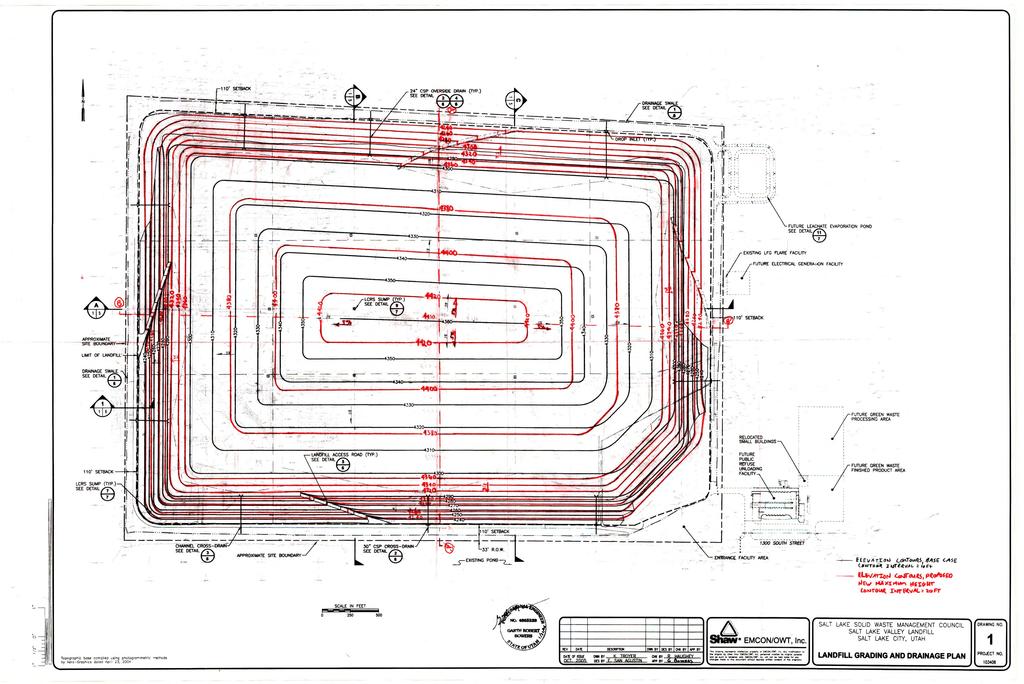
2 PROJECT DESCRIPTION: This is a conditional use request for a height increase for the Salt Lake Valley Landfill, located at approximately 6030 W California Avenue (1400 South.) The landfill is currently limited to 150 feet in height. The applicant would like to increase the height limit for the landfill from 150 feet to 205 feet in height, an increase of 55 feet. There is no specific height limit for landfills in the Zoning Ordinance. The height limits for individual landfills are established by the Planning Commission through the Conditional Use process. KEY ISSUES: The key issues listed below have been identified through the analysis of the project, neighbor and community input, and department review comments. 1. Compatibility of Additional Height with Surrounding Properties West of the Landfill Two neighboring landfills to the west have also been approved for over 200 feet of height. These include the Mountain View Landfill, located directly adjacent to the west of the Salt Lake Valley Landfill and the construction waste landfill at 7213 W California Ave. These landfills have been approved for 205 feet and 200 feet of height respectively. The Salt Lake Valley Landfill is the only remaining portion of land within the Landfill Overlay zone that has not been approved for 200 feet of height or higher. Additionally, the Kennecott Tailings Pond is expected to be expanded to approximately 7200 West, which is half a mile from the western edge of the Salt Lake Valley Landfill. According to the Notice of Intent filed with the Utah Department of Environment Quality, the final design height of the tailings pond is at an elevation of 4,462 feet, which is approximately 243 feet in height measured from the existing ground level elevation (4219 feet) on 7200 West. This means the top of the Salt Lake Valley Landfill will ultimately be below the height of the Kennecott Tailings Pond. As shown on the above map, the portion of the tailings pond closest to the landfill is outside of City boundaries and not subject to City regulations. Part of the proposed tailings pond to the north will be within City boundaries but state law concerning mine expansion rights (Utah Code ) limits the regulatory authority the City will have over the expansion. Page 2
3 An additional piece of land between the Salt Lake Valley Landfill and 7200 West is owned by Kennecott and is zoned for light industrial uses. These types of uses are unlikely to be negatively impacted by the additional landfill height. None of the current or potential uses to the west are expected to be negatively impacted by the additional landfill height as they are similar or the same as the landfill use. East of the Landfill To the east of the landfill is an area zoned Transitional Overlay. The transitional area is intended to buffer the uses in the Manufacturing zones to the east from the impacts of the landfill use. This area is also owned by the Salt Lake Valley Landfill, so there is unlikely to be any other development in this area that would be negatively impacted by the landfill height. Beyond the transitional area to the east there is a power transmission corridor which additionally buffers any land uses from the landfill. Beyond that power corridor, 1200 feet to the east of the landfill, are lots zoned for light industrial development. As an additional buffer, the Mountain View Corridor highway is planned to be located on the eastern edge of the Transitional Overlay area. The highway will create an additional barrier between other land uses and the landfill. With the 1,200 foot wide Transitional Overlay zoning and planned highway, the nearby properties are expected to be adequately buffered from any impacts from the additional landfill height. North of the Landfill To the north of the landfill is a 250' wide rail corridor and beyond that area are a few vacant properties owned by Kennecott and Property Reserve Inc. These properties are zoned for industrial uses and such uses are unlikely to be negatively impacted by an additional 55 feet of landfill height. South of the Landfill To the south of the landfill are the Lee Kay Ponds, which provide wetlands for birds and fish. The ponds were originally created to mitigate the loss of wetlands when the landfill moved to its current location. The additional height for the landfill is not expected to have any negative impacts on these ponds. General Compatibility Considerations Overall, the landfill is surrounded by uses that are unlikely to be negatively affected by the additional height allowance and is buffered from nearby uses by off-site horizontal separation. The maximum height of the landfill itself will also be setback on-site so as to reduce the potential for any visual impacts. As shown in the east to west elevation plan in Attachment C, the landfill mound will be set back 110 feet from all property lines and will then gradually rise over approximately 450 feet to a height of 150 feet. The landfill mound will then rise another 55 feet over the course of 2200 feet for a final height of 205 feet. In the case of the north to south elevation, the landfill will rise 150 feet over the course of approximately 350 feet and then rise to a height of 205 feet over the course of 1200 horizontal feet. This gradual sloping of the landfill height reduces the potential for any significant visual impacts on surrounding properties. The landfill height is sufficiently setback from other properties by on and off-site horizontally buffering so as not to cause any negative impacts to the surrounding land uses. Further, an additional 55 feet of height is not expected to significantly increase or create any new detrimental impacts that would not be created by the existing 150 foot landfill. Strong odors occasionally emanate from the landfill property and travel a few miles into residential areas south of the landfill property. However, these odors are generally not related to the landfill itself and are caused by other uses on the landfill property, such as open air bio-solid waste processing activity on the west end of the property. These activities occur at ground level and the additional height allowed for the landfill will not increase this activity. Ultimately, these other uses will have to move to another location as the landfill mound will fill up the entirety of the property as shown on the proposed plans located in Attachment C. The general waste going into the landfill does not sit exposed to open air for very long and is instead covered by soil, reducing the potential for odors. Details of odor and other potential nuisance control methods are located in the Landfill Master Plan excerpt in Attachment D. Page 3
4 NEXT STEPS: If the conditional use is approved, the applicant will be required to comply with all other department/division requirements and obtain all necessary building permits for the project. They will also be required to obtain all other state and federal approvals necessary for the landfill expansion and demonstrate that they have received those approvals before the Planning Division can give the final sign off on the additional height approval. Page 4
5 ATTACHMENT A: VICINITY MAPS Page 5
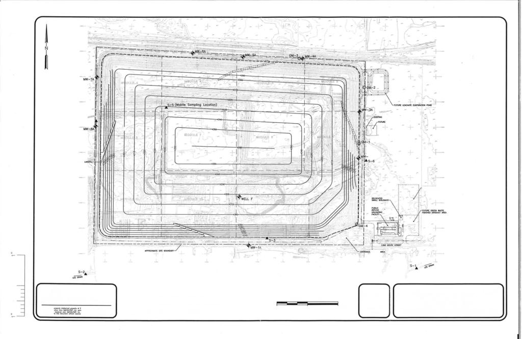
6 Vicinity Map CG 150 S 5600 W 6400 W 5700 W 300 S M-1 M W CG CG 610 S 700 S Requesting 205' Current Limit 150' Shea Dr CG M-1 Approved for 205' Currently 150' High CG OS Mountain View Landfill Salt Lake Valley Landfill 7200 W Legend M W M-1 OS CG M S City Boundary Rd M-1 po Tem Mountain View Corridor 7500 W M-1 California Ave Lee Kay Ponds Construction AG Waste Landfill CG 5500 W Approved for 200' Leg a cy View St 1100 S CG M-1 Tailings AGPond Expansion Area Zoning Districts AG Agricultural 2100 S CG General Commercial M-1 Light Manufacturing OS Open Space Transitional Overlay Landfill Overlay Landfill Mound Area Overall Property 0 ¼ ½ Mile 1


7 ATTACHMENT B: PHOTOS View north into the landfill property from California Ave, showing existing landfill mounds View north into the landfill property from California Ave, showing existing landfill mounds Page 6


8 Westward view along California Ave. An existing 150 tall landfill located west of the Salt Lake Valley landfill can be seen on the right. The Lee Kay Ponds can be seen on the left side of the street. Close up view looking north from California Ave showing existing 150 tall landfill Page 7

9 View west toward the landfill from 5600 West. The east edge of the landfill can be seen on the horizon. The landfill currently rises to approximately 75 feet in height. Page 8
10 ATTACHMENT C: SITE PLAN & NARRATIVE Page 9
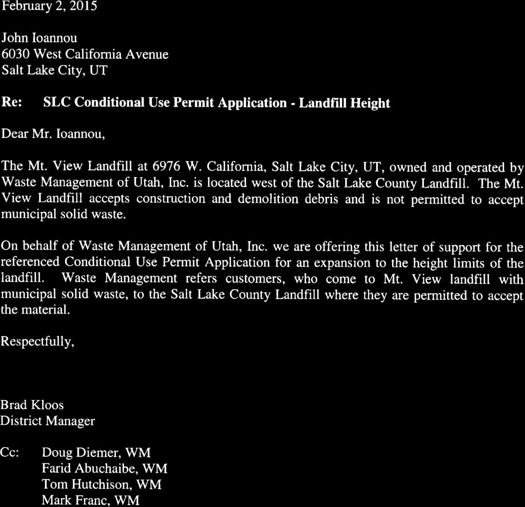
11 Conditional Use Permit Salt Lake City Planning Salt Lake Valley Solid Waste Management Facility 6030 West California Avenue Salt Lake City, UT March 2, 2015 Contact: Debbie Lyons, Salt Lake City Sustainability Division, Additional Information 1. Project Description The Salt Lake Valley Landfill, a joint venture owned equally by Salt Lake City and Salt Lake County occupies 500 acres at 6030 West California Avenue, Salt Lake City, Utah. Salt Lake County staff manages the landfill and employs 40 full-time employees. The landfill accepts an average of 1,300 tons of municipal solid waste per day. Salt Lake City manages construction and engineering, and has contracted with CH2MHill to provide regulatory assistance and update the facility s permits required by the State Division of Environmental Quality and Department of Air Quality. The Salt Lake Valley Landfill is in process of updating its Master Plan and Post-Closure Plan and is requesting a Conditional Use approval from the Salt Lake City Planning Commission to increase the height of the landfill to 205 feet, which is the approved height of the Mountain View Landfill just west of the Salt Lake Valley Solid Waste Management Facility. Allowing the additional height will significantly extend the life of the landfill and is a cost efficient use of the existing footprint of the landfill. The cost efficiency will benefit all users of the landfill, which include valley-wide residents, businesses and non-profit organizations. 2. Conditional Use Information Operating/Delivery Hours: 7:00 AM to 5:00 PM, Monday through Saturday. Closed on Sundays, Thanksgiving, Christmas, and New Years Day. Adjacent land uses (abutting and across the street properties): North: Railroad right-of-way and railroad line East: 80 acre Knorr Property buffer owned by SL County South: California Avenue and Utah State Division of Wildlife Resources Property West: Mountain View Landfill and vacant Kennecott property Number of employees during highest shift: 27 Number of seats provided: Not Applicable Have you discussed the project with nearby property owners? What has been the response? The Mountain View Landfill offered the attached letter of support for this Conditional Use Application. (See Item #6.)
12 4. Site Plan
13
14 5. Elevation Drawing
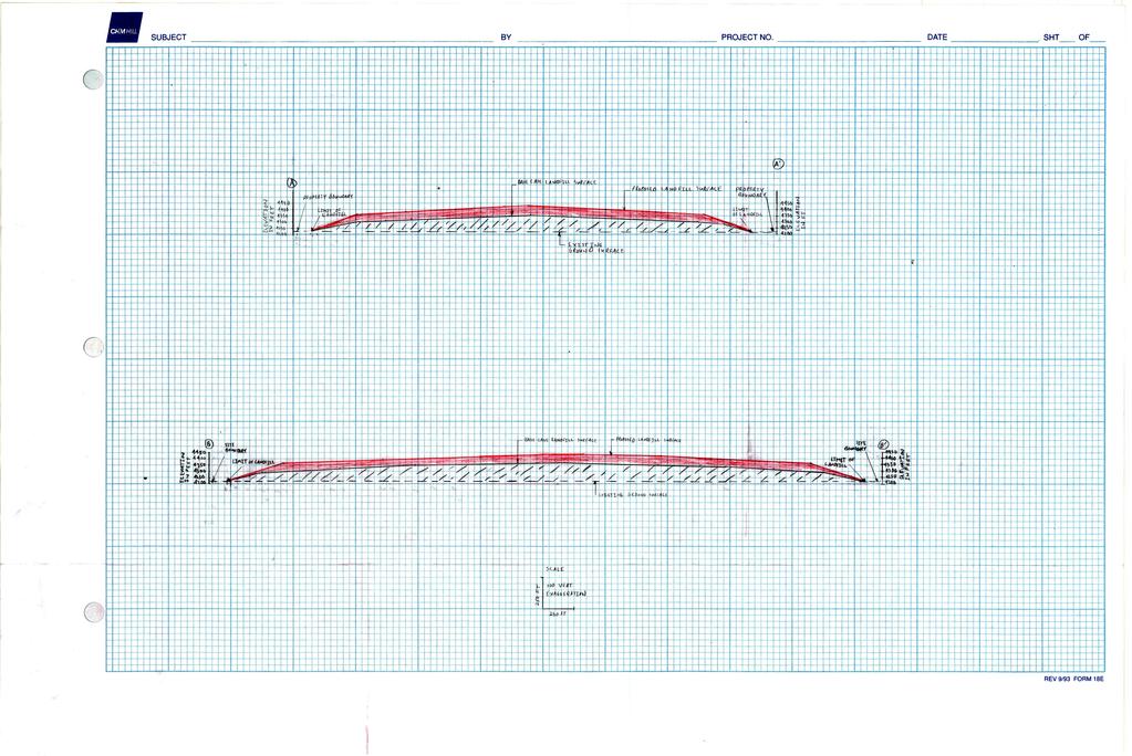
15
16 6. Attachment: Letter of Support from Waste Management of Utah, Inc, Owner and Operator of Mountain View Landfill

17
18 ATTACHMENT D: LANDFILL MASTER PLAN EXCERPTS Page 10

19
20
21
22

23

24

25
26
27
28
29
30

31
32
33
34
35
36
37
38
39
40

41
42 ATTACHMENT E: EXISTING CONDITIONS & ZONING REQUIREMENTS CURRENT ZONING REQUIREMENTS Regulation Zone Regulation Proposal Complies? Landfill Height Front Yard Setback Side Yard Setback Rear Yard Setback Landscape Yards/Buffers Proximity to Residential and Institutional Zones Minimum Lot Size Height Regulated by the Planning Commission 205' Conditional Use Approval Required Min. 30' 110' Yes Min. 10' 110' Yes Min. 10' 110' Yes As approved by the Planning Commission Min. 1,000 feet from such uses Min. 30' Natural Vegetation Yes, landscaping is at the discretion of the Planning Commission ~5 Miles Yes 8 Acres ~537 Acres Yes ADJACENT LAND USE The land use surrounding the site is: East: Vacant land, gas and power transmission corridor, and future Mountain View Highway Corridor West: Vacant land and landfill approved for 205' in height North: 200' wide rail corridor, vacant land, and portion of future Mountain View Highway Corridor South: Lee Kay Ponds (wetlands) and Lee Kay Public Shooting Range and dog training grounds ADJACENT ZONING The zoning surrounding the site is: East: Transitional Overlay and M-1, Light Manufacturing West: Landfill Overlay and M-1, Light Manufacturing North: M-1, Light Manufacturing South: Open Space Page 11
43 ATTACHMENT F: ANALYSIS OF STANDARDS 21A Standards for Conditional Use Approval Standards: A conditional use shall be approved unless the planning commission, or in the case of administrative conditional uses, the planning director or designee, concludes that the following standards cannot be met: 1. The use complies with applicable provisions of this title: Analysis: The proposal is located in the Landfill Overlay zoning district. Landfills are a conditional use in the Landfill Overlay district and changes to an existing landfill require an additional conditional use process. Landfill height is regulated by the Planning Commission through the conditional use process and so the height increase is being processed as a conditional use. As per section 21A I, the application for a landfill shall also be accompanied by the following: 1. Plan for controlling and/or mitigating pests that may be attracted to the site; 2. An end use plan; and 3. A landscape plan indicating how the proposed landscaping will mitigate noise, dust, or other impacts on surrounding uses. If surrounding properties are undeveloped, the landscape plan shall address potential impacts on uses permitted within the applicable zoning districts for such undeveloped property. In accordance with that provision, the landfill has a comprehensive master plan that includes plans for pest control and the end use of the property, including how the end use of the property will remain compatible with surrounding land uses. Excerpts of the master plan are included in Attachment D. The current master plan is in the process of being updated and will be updated to reflect the additional height allowance if approved by the Planning Commission. Regarding the landscaping, the applicant has submitted a site plan showing a 110' setback for the landfill mound from the property boundaries. As shown in the table in Attachment E, the setback and other aspects of the landfill comply with the general zoning regulations for landfills. As noted in the table, requiring landscaping in the front yard is at the discretion of the Planning Commission. As such, staff is recommending that that natural vegetation be allowed to continue to occupy the first 30' deep front yard area. Besides a small segment at the entrance to the dump, there is no curb, gutter, or landscaped park strips along California Avenue next to the landfill. The area between the edge of the street and the property line is occupied by natural vegetation. Therefore any formal landscaping would be screened from public view by the existing natural vegetation in the right-of-way along the street and provide no public benefit. Additionally, the Lee Kay Ponds across the street are used as natural open space for birds and other animal and the site consists of ponds and natural vegetation. The natural vegetation located along the front yard of the landfill site is similar to the natural vegetation located across the street at the Lee Kay Ponds. This site and use would not benefit from the addition of landscaping on the landfill site. Further, other uses on adjacent properties would also not benefit from additional landscaping along other property boundaries, due to the amount of horizontal separation between the landfill itself and developable industrial zoned land. Given these conditions, staff is not recommending any Page 12
44 other front yard landscaping or landscaping along any other property lines because the natural vegetation meets the intent of the landscape ordinance. The landscaping requirements allow natural vegetation in areas that are required to be landscaped. The Landfill Overlay district regulations in section 21A J require landfills to obtain approval from all other necessary regulatory agencies before the Planning Division can sign off on the landfill conditional use approval. Some of the required regulatory approvals for the landfill cannot be obtained until the Planning Commission has approved the additional height. As such, documentation of those approvals will be required before the Planning Division can provide final sign off for the landfill height and is a conditional of approval. The property is located in the Airport Flight Path Protection Overlay. The overlay imposes height standards that limit development height near the airport. As discussed by the Airports department in Attachment G, the proposed height creates no observed impacts to airport operations. The applicant is required to record an avigation easement across the property if it has not already been created, and is a condition of approval. Finding: The proposal will comply with the applicable provisions of the Salt Lake City Zoning Ordinance on the condition that regulatory agency approvals are documented and an avigation is recorded against the property. 2. The use is compatible, or with conditions of approval can be made compatible, with surrounding uses; Analysis: The surrounding uses are discussed under issue 1 on page 2. Generally, the additional landfill height is not expected to cause any additional negative impacts on surrounding properties due to horizontal separation and buffering, and the surrounding properties current and potential light industrial type uses. Finding: The surrounding area generally consists of current and potential light industrial uses that would not be negatively impacted by the additional height allowed for the landfill. The additional height is also sufficiently set back so as to not have a substantial negative impact on surrounding uses. The height will be compatible with the surrounding uses. 3. The use is consistent with applicable adopted city planning policies, documents, and master plans; and Analysis: The site is located in the Northwest Quadrant community area. There is no adopted master plan for the Northwest Quadrant community area. The zoning map, which was adopted in 1995, serves as the future land use map for the area. The property is zoned Open Space and Landfill Overlay. The use of the property for a landfill complies with this zoning. The City Council adopted the Landfill Overlay regulations and thereby established a policy to allow landfills to be developed up to a height determined to be appropriate by the Planning Commission through the conditional use process. As such, the additional height is being processed through this conditional use petition. Finding: The proposed additional height meets adopted city planning policies, documents, and master plans. Page 13
45 4. The anticipated detrimental effects of a proposed use can be mitigated by the imposition of reasonable conditions (refer to Detrimental Impacts Chart below for details). 21a B Detrimental Effects Determination In analyzing the anticipated detrimental effects of a proposed use, the planning commission or administrative hearing officer shall determine compliance with each of the following: Criteria Finding Rationale 1. This title specifically authorizes the use where it is located 2. The use is consistent with applicable policies set forth in adopted citywide, community, and small area master plans and future land use maps 3. The use is well-suited to the character of the site, and adjacent uses as shown by an analysis of the intensity, size, and scale of the use compared to existing uses in the surrounding area 4. The mass, scale, style, design, and architectural detailing of the surrounding structures as they relate to the proposed have been considered 5. Access points and driveways are designed to minimize grading of natural topography, direct vehicular traffic onto major streets, and not impede traffic flows 6. The internal circulation system is designed to mitigate adverse impacts on adjacent property from motorized, non-motorized, and pedestrian traffic 7. The site is designed to enable access and circulation for pedestrian and bicycles 8. Access to the site does not unreasonably impact the service level of any abutting or adjacent street 9. The location and design of off-street parking complies with applicable standards of this code 10. Utility capacity is sufficient to support the use at normal service levels 11. The use is appropriately screened, buffered, or separated from adjoining dissimilar uses to mitigate potential use conflicts 12. The use meets City sustainability plans, does not significantly impact the quality of surrounding air and water, encroach into a river or stream, or introduce any hazard or environmental damage to any adjacent property, including cigarette smoke Complies Complies Complies Complies Complies Complies Complies Complies Complies Complies Complies Complies The proposed landfill height is allowed as a conditional use by the zoning district in which it is located and is consistent with applicable land use policies. The use is located in an area generally zoned for industrial uses. The zoning map serves as the future land use map for this area of the City. As such, the use is allowed by the applicable zoning and is consistent with the zoning map. As discussed under the issues section on page 2, the surrounding land uses in the area are currently or potentially light industrial uses. These types of uses are unlikely to be negatively impacted by additional landfill height. Additionally, the site is horizontally buffered from surrounding properties further reducing the potential for negative impacts. The surrounding land is zoned for industrial uses, with some Open Space zoned land to the south. Industrial uses are generally located in large buildings designed for functionality and do not generally include significant architectural detailing. These buildings generally have few windows and many are used for warehousing with few employees on site. As such, the additional height of the landfill is expected to be compatible with or have little to no impact on surrounding industrial type development. This is an existing landfill with existing access points located along California Avenue. California Avenue ends a few hundred feet after the landfill and the small amount of traffic on this street is generally landfill related. The additional height will not increase traffic flow to the landfill and so will not impede traffic flows on this street. The landfill is not located adjacent to other uses that would be impacted by the internal circulation on the site. The landfill can accommodate pedestrian and bicycle access at its front entrance, however, the vehicle activity across the rest of the site makes it unsafe for pedestrians or bicyclists to have circulation across the majority of the site. The proposal will not increase traffic to the landfill and so will not impact the service level of abutting or adjacent streets. The proposal will not require additional off-street parking. The proposal will not require additional utility service. As discussed under the issues section on page 2, the land use is sufficiently separated from adjoining dissimilar uses so as to mitigate potential use conflicts. The landfill is subject to monitoring by environmental agencies, such as the Utah Department of Environmental Quality, and is maintained so as to not have an environmental impact on surrounding air or water. Water is regularly monitored and tested on and around the site. Some of the monitoring sites are shown in the Environmental Monitoring Facilities site plan in Attachment D. The proposal will not likely result in any environmental impacts Page 14
46 13. The hours of operation and delivery of the use are compatible with surrounding uses 14. Signs and lighting are compatible with, and do not negatively impact surrounding uses 15. The proposed use does not undermine preservation of historic resources and structures Complies Complies Complies with regard to the associated criteria. The landfill is located in an industrial area where any hours of operation or delivery will not have detrimental impacts on surrounding properties. The landfill is located in an industrial area where signs and lighting will not negatively impact similarly industrial or heavy commercial surrounding uses. There are no residential uses nearby, so staff does not anticipate any detrimental effects from lighting. The proposal is not associated with any historic resources or structures. Finding: In analyzing the anticipated detrimental effects of the proposed use, Staff finds that the request complies with the criteria listed above. Conditions Imposed The Planning Commission, or planning director or designee in the case of administrative conditional uses, may impose any condition upon a proposed conditional use in order to address any of the factors listed in section 21A of the zoning ordinance. The conditions may include: 1. Conditions on the scope of the use; its character, location, hours and methods of operation, architecture, signage, construction, landscaping, access, loading and parking, sanitation, drainage and utilities, fencing and screening, and setbacks; and 2. Conditions needed to mitigate any natural hazards; assure public safety; address environmental impacts; and mitigate dust, fumes, smoke, odor, noise, vibrations; chemicals, toxins, pathogens, gases, heat, light, and radiation. Analysis: The landfill is located in an area of the City that is generally industrial and is buffered from surrounding uses by a transitional zoning overlay and other horizontal separation. The additional height allowance for the landfill will not result in or increase any detrimental impacts to the surrounding industrial type development that is permitted in the area. The additional height does not result in new or increased natural hazards that do not already exist with a lower height landfill. Planning Staff does not anticipate any detrimental effects from the proposal that require the imposition of additional conditions. Finding: The proposal meets this standard. Planning Staff does not expect any detrimental effects from the proposal that require additional conditions. Additional Conditions for Landfills (21A L) In addition to the conditions stated above, and the standards for conditional uses outlined in section 21A of this title the planning commission may impose conditions and limitation upon a conditional use concerning use, construction, character, location, landscaping, screening, parking, hours and days of operation and other matters that may be necessary or appropriate to prevent or minimize any adverse impact. 1. The planning commission may require that storage of materials in the transitional area be enclosed in a structure if proposed open storage or recycling of materials may have a material negative impact on a neighboring land use. 2. The planning commission shall specify such conditions in writing when approving the conditional use. 3. The violation of any conditions of approval shall constitute grounds for revocation of the conditional use approval. Analysis: As discussed in the above Conditions Imposed section, staff does not anticipate any detrimental effects from the proposed additional 55 feet of height that require additional conditions to be imposed on the use. Finding: Staff does not recommend any additional conditions of approval. Page 15
47 ATTACHMENT G: PUBLIC PROCESS AND COMMENTS PUBLIC PROCESS AND INPUT The proposal was taken to a public open house on April 16 th. Public hearing notice mailed on May 14 th. Public hearing notice posted on property on May 14 th. Public hearing notice posted on City and State websites on May 14 th. Public hearing notice ed to the Planning Division list serve on May 14 th. The following is a list of the public comments received for this project: Two City residents discussed the proposal with staff at the public open house and expressed their support for the proposal. Page 17
48 ATTACHMENT H: DEPARTMENT REVIEW COMMENT The proposed conditional use was sent to the departments listed below for review and comment. Public Utilities They need to make sure that they update their DEQ permits and the Salt Lake City storm water discharge permits. Staff Note: Documentation of compliance with all required regulatory agency approvals is a condition of approval. Transportation No issues. Zoning The plan provided for review does not address 21A H. Required Yard and Buffer Requirement. Staff Note: Please see the zoning standard review table in attachment E. Police No comments. Airports Thank you for the notice regarding a conditional use application for a height increase for the existing Salt Lake Valley Landfill, located at approximately 6030 W California Avenue.. This address is in the Salt Lake City's airport influence zone "C" and is listed as a area exposed to moderate levels of aircraft noise and having specific height restrictions. Salt Lake City requires an avigation easement for new development in this zone. The owner or developer should contact me at the address or below, to complete the avigation easement if one has not already been created. This project creates no observed impacts to airport operations. Staff Note: Recording of the required avigation easement is a condition of approval. Page 18
49 ATTACHMENT I: POTENTIAL MOTIONS Staff Recommendation: Based on the findings and analysis in the staff report, testimony, and discussion at the public hearing, I move that the Planning Commission approve the request for the proposed landfill height increase to 205' with the following conditions: 1. The applicant shall document that all approvals have been granted by all necessary county, state and federal agencies including the approval of a financial assurance plan sufficient to assure adequate closure, post closure care and corrective action of the facility and demonstration of compliance with the state of Utah division of solid and hazardous waste administrative rules. 2. The applicant shall record an avigation easement against the property in compliance with the requirement from the Airports Department. Not Consistent with Staff Recommendation: Based on the testimony, plans presented and the following findings, I move that the Planning Commission deny the request for the proposed landfill height increase due to not complying with the following standards: (The Planning Commission shall make findings on the applicable Conditional Use standards and specifically state which standard or standards are not being complied with. Please see Attachment F for applicable standards.) Page 19
Staff Report. Conditional Use PLANNING DIVISION COMMUNITY & ECONOMIC DEVELOPMENT. Salt Lake City Planning Commission
 Staff Report PLANNING DIVISION COMMUNITY & ECONOMIC DEVELOPMENT To: From: Salt Lake City Planning Commission Maryann Pickering, Principal Planner (801) 535-7660 Date: December 10, 2014 Re: Church of Scientology
PLNPCM Carl s Jr. Commercial Parking Lot at Redwood Road and 1700 South
 Staff Report PLANNING DIVISION COMMUNITY & NEIGHBORHOODS To: Salt Lake City Planning Commission From: Casey Stewart; 801-535-6260 Date: November 4, 2016 Re: PLNPCM2015-00874 Carl s Jr. Commercial Parking
PLANNING COMMISSION STAFF REPORT Legislative Item
 PLANNING COMMISSION STAFF REPORT Legislative Item Manufacturing Districts Monument Sign Height Zoning Text Amendment PLNPCM2013-00197 Citywide August 28, 2013 Planning Division Department of Community
Asbury Chapel Subdivision Sketch Plan
 Asbury Chapel Subdivision Sketch Plan PART 1: PROJECT SUMMARY Applicant: NVR Inc. Project Size: +/- 76.13 acres Parcel Numbers: 02101112,02116101,02116112, 02116113 Current Zoning: Transitional Residential
CHAPTER SPECIAL PURPOSE AND OVERLAY ZONING DISTRICTS
 Special Purpose and Overlay Zoning Districts 106.28.010 CHAPTER 106.28 - SPECIAL PURPOSE AND OVERLAY ZONING DISTRICTS SPECIAL PURPOSE AND OVERLAY ZONING DISTRICTS Sections: 106.28.010 - Purpose 106.28.020
Planned Development Review Revisions (Project No. PLNPCM )
") Planned Development Review Revisions (Project No. PLNPCM2014-00139) Standard residential development Planned Development Example: Smaller lot sizes than what is allowed to create open space amenity. What
Planned Development Review Revisions (Project No. PLNPCM2014-00139) Standard residential development Planned Development Example: Smaller lot sizes than what is allowed to create open space amenity. What
ARTICLE VI: SITE PLAN REVIEW
 Section 6.01 - Site Plan Review (All Districts) ARTICLE VI: SITE PLAN REVIEW Site plans give the Planning commission an opportunity to review development proposals in a concise and consistent manner. The
APPENDIX J PERFORMANCE STANDARDS FOR GRAVEL MINE, PIT MINE, OR QUARRY
 APPENDIX J PERFORMANCE STANDARDS FOR GRAVEL MINE, PIT MINE, OR QUARRY A. Purpose: 1. Regulatory Requirement and Use Mitigation: The purpose of this appendix is to provide a regulatory context (standards)
Administrative Hearing Staff Report
 Administrative Hearing Staff Report Peck Striping Outdoor Storage Conditional Use PLNPCM2012-00413 1775 South Redwood Road Hearing date: August 23, 2012 Planning Division Department of Community & Economic
HISTORIC LANDMARK COMMISSION STAFF REPORT
 HISTORIC LANDMARK COMMISSION STAFF REPORT Park Strip Raised Planter Boxes Minor Alteration PLNHLC2014-00603 163 D Street Meeting Date: November 6, 2014 Planning Division Department of Community and Economic
PC RESOLUTION NO
 PC RESOLUTION NO. 14-01-14-02 TENTATIVE TRACT MAP fttm) 17441. REZONE {RZ) 13-003, ARCHITECTURAL CONTROL (AC) 13-003, TREE REMOVAL PERMIT (TRP) 13-052. GRADING PLAN MODIFICATION (GPM) 13-002. CONDITIONAL
At Your Disposal CUP Amendment, Lot 20, Village Service Commercial, at 128 Bastille Dr. (PLN17-208)
") MEMORANDUM Archuleta County Development Services Planning Department 1122 HWY 84 P. O. Box 1507 Pagosa Springs, Colorado 81147 970-264-1390 Fax 970-264-3338 TO: Archuleta County Planning Commission FROM:
MEMORANDUM Archuleta County Development Services Planning Department 1122 HWY 84 P. O. Box 1507 Pagosa Springs, Colorado 81147 970-264-1390 Fax 970-264-3338 TO: Archuleta County Planning Commission FROM:
Glenborough at Easton Land Use Master Plan
 Implementation 114 9.0 IMPLEMENTATION 9.1 OVERVIEW This chapter summarizes the administrative procedures necessary to implement the proposed land use plan, infrastructure improvements, development standards,
City of Lafayette Study Session Staff Report Design Review Commission
 ++ City of Lafayette Study Session Staff Report Design Review Commission Meeting Date: January 08, 2018 Staff: Subject: Chris Juram, Planning Technician SS12-17 Miramar Homebuilders, R-20 Zoning: Request
David J. Gellner, AICP, Principal Planner, , PLNSUB Harmons Brickyard Fuel Center Planned Development
 Staff Report PLANNING DIVISION COMMUNITY & NEIGHORHOOD DEVELOPMENT To: From: Salt Lake City Planning Commission David J. Gellner, AICP, Principal Planner, 801-535-6107, david.gellner@slcgov.com Date: January
City of Lafayette Study Session Staff Report Design Review Commission
 City of Lafayette Study Session Staff Report Design Review Commission Meeting Date: April 24, 2017 Staff: Payal Bhagat, Senior Planner Subject: HDP18-15 & HDP31-15 Ramesh Patel & Melcor Development (Owners),
SITE PLAN REVIEW PROCESS
 BOWNE TOWNSHIP PO Box 35, 8240 Alden Nash Road, Alto, Michigan 49302 Ph. 616-868-6846 Fax 616-868-0110 http://www.bownetwp.org SITE PLAN REVIEW PROCESS 1. Application Form and Fee Schedule Site Plan Review
DEPARTMENT OF PLANNING JEFFERSON PARISH, LOUISIANA
 DEPARTMENT OF PLANNING JEFFERSON PARISH, LOUISIANA DESIGN REVIEW REPORT DOCKET NO: CPZ--16 SUMMAR NO.: : : Paul D. Johnston AT LARGE: A: Christopher L. Roberts B: Cynthia Lee-Sheng ADVERTISING DATES: PAB
Planning Commission Staff Report
 3330 South 1300 East Millcreek, UT 84106 801-214-2700 millcreek.us File #CU-18-016 Planning Commission Staff Report Meeting Date: October 17, 2018 Applicant: Lotus Monarch Homes, LLC Property Address:
Kingfisher Planned Development (PLNSUB ) and Special Exception (PLNPCM ) Planned Development and Special Exception
 and Special Exception (PLNPCM ) Planned Development and Special Exception") Staff Report PLANNING DIVISION COMMUNITY & ECONOMIC DEVELOPMENT To: From: Salt Lake City Planning Commission Maryann Pickering, Principal Planner (801) 535-7660 Date: October 22, 2014 Re: Kingfisher Planned
Staff Report PLANNING DIVISION COMMUNITY & ECONOMIC DEVELOPMENT To: From: Salt Lake City Planning Commission Maryann Pickering, Principal Planner (801) 535-7660 Date: October 22, 2014 Re: Kingfisher Planned
Site Plan Review Residential Accessory Building
 COMMUNITY DEVELOPMENT DEPARTMENT Planning Division P.O. Box 490 333 Broadalbin Street SW Albany, OR 97321 Phone (541) 917-7550 Fax (541) 917-7598 www.cityofalbany.net Site Plan Review Residential Accessory
PART 1: PROJECT SUMMARY. The application is Attachment A. The site plan is Attachment B.
 Belleterre Subdivision Sketch Plan Town Board 8.7.17 Belleterre Subdivision Sketch Plan PART 1: PROJECT SUMMARY Applicant: Bowman Development Project Size: +/- 20.85 acres Parcel Number: 01115104 and 01115121
(APN: );
;") Gardnerville Town Board AGENDA ACTION SHEET 1. For Possible Action: Discussion to approve, approve with modifications or deny a project review application for Chase Bank located South of Lampe Drive, East
Gardnerville Town Board AGENDA ACTION SHEET 1. For Possible Action: Discussion to approve, approve with modifications or deny a project review application for Chase Bank located South of Lampe Drive, East
PLANNED UNIT DEVELOPMENT APPLICATION
 PLANNED UNIT DEVELOPMENT APPLICATION CITY OF THE DALLES Community Development Department 313 Court Street The Dalles, OR 97058 (541) 296-5481, ext. 1125 Fax (541) 298-5490 www.ci.the-dalles.or.us Date
ARTICLE RRCO RED ROCK CORRIDOR OVERLAY DISTRICT
 ARTICLE 11.10 RRCO RED ROCK CORRIDOR OVERLAY DISTRICT (adopted 11/22/2011 MC16-116-11) SECTIONS: 11.10.01 Intent 11.10.02 Boundaries of District 11.10.03 Development Standards 11.10.04 Variance 11.10.01
AWH REPORT OF THE PLANNING AND DEVELOPMENT DEPARTMENT FOR APPLICATION FOR REZONING ORDINANCE TO PLANNED UNIT DEVELOPMENT
 AWH REPORT OF THE PLANNING AND DEVELOPMENT DEPARTMENT FOR APPLICATION FOR REZONING ORDINANCE TO PLANNED UNIT DEVELOPMENT MAY 8, 2014 The Planning and Development Department hereby forwards to the Planning
SPECIFIC PLAN Requirements
 CITY OF LANCASTER PLANNING DEPARTMENT 44933 Fern Avenue, Lancaster, California 93534 (661) 723-6100 SPECIFIC PLAN Requirements Purpose The purpose of a specific plan is to provide for the logical development
PART 1: PROJECT SUMMARY. Proposed Land Use: 120 single-family lots. The application is Attachment A. The site plan is Attachment B.
 PART 1: PROJECT SUMMARY Applicant: JBH Development, LLC and Hopper Communities, INC Project Size: +/- 80.48 acres Parcel Number: 01513107, 01513108, 01513109, 01513113, 01513120, 01513121, 01513122, 01513124,
Regulation Changes for Open Space and Similar Uses
 Regulation Changes for Open Space and Similar Uses What is the Project? This project is an analysis of the Zoning Ordinance relating to public lands and open space regulations. The proposed text amendments
Planning Commission Staff Report June 5, 2008
 Owner/Applicant Taylor Village Sacramento Investments Partners, LP c/o Kim Whitney 1792 Tribute Road #270 Sacramento, CA 95815 Staff Recommendation Planning Commission Staff Report Project: File: Request:
Town of Portola Valley General Plan. Nathhorst Triangle Area Plan
 Town of Portola Valley General Plan Amended December 10, 1997 Table of Contents Introduction... 1 Planning Area... 1 Objectives... 2 Principles... 2 Standards... 4 Description... 4 Community Commercial...
GENERAL INFORMATIONaaaaaaaaaaaaaaaaaaaaaaaaaaaaaaaa
 To: Planning and Zoning Commission From: City Staff Date: November 15, 2016 Re: Case #16026 Raymore Activity Center Site Plan GENERAL INFORMATIONaaaaaaaaaaaaaaaaaaaaaaaaaaaaaaaa Applicant/ Property Owner:
SDOT DPD. SDOT Director s Rule DPD Director s Rule DCLU DR SED DR of 7 CITY OF SEATTLE
 SDOT SDOT Director s Rule 2-07 DPD Applicant: CITY OF SEATTLE Page 1 of 7 Supersedes: DCLU DR 11-93 SED DR 93-4 Seattle Department of Transportation (SDOT) Department of Planning and Development (DPD)
MEMORANDUM. Planning and Zoning Division Department of Community Development TO: FROM: DATE: July 23, SUBJECT: PLNSUB : Salt City Plaza
 MEMORANDUM 451 South State Street, Room 406 Salt Lake City, Utah 84111 (801) 535-7757 Planning and Zoning Division Department of Community Development TO: FROM: Planning Commission Doug Dansie, Planning
Planning Division Department of Community & Economic Development. Applicants: Phil Winston, Highland Partners
 Planning Commission Staff Report Administrative Item Commercial Office Building Conditional Use PLNPCM2013-00450 Planned Development PLNSUB2013-00455 2816 & 2818 South Highland Drive Hearing date: August
DEPARTMENT OF PLANNING JEFFERSON PARISH, LOUISIANA
 DEPARTMENT OF PLANNING JEFFERSON PARISH, LOUISIANA DESIGN REVIEW REPORT : SUMMAR NO.: 4469 (S) Paul Johnston AT LARGE: A Chris Roberts B Cynthia Lee-Sheng ADVERTISING DATES: PAB PUBLIC HEARING: HEARING:
CITY OF ZEELAND PLANNING COMMISSION
 APPLICATION FOR SITE PLAN REVIEW AND SPECIAL LAND USE Date City Official App. Filing Fee Rec'd ($350) NOTE TO APPLICANT: Please submit this application for Site Plan Review along with twenty (20) copies
Town of Windham. Planning Department 8 School Road Windham, ME voice fax
 Town of Windham Planning Department 8 School Road Windham, ME 04062 voice 207.864-5960 fax 207.892.1916 MEMO DATE: TO: Staff Review Committee FROM: Amanda Lessard, Planner Cc: Ellen Rathbone, St. Germain
SITE PLAN REVIEW APPLICATION
 SITE PLAN REVIEW APPLICATION CITY OF THE DALLES Community Development Department 313 Court Street The Dalles, OR 97058 (541) 296-5481, ext. 1125 Fax (541) 298-5490 www.ci.the-dalles.or.us Date Filed File#
CITY OF MANHATTAN BEACH DEPARTMENT OF COMMUNITY DEVELOPMENT. TO: Parking and Public Improvements Commission
 Clay Curtin, Management Analyst (I the same walls at a maximum of 1 foot tall. Section 7.36.150 of the Municipal Code permits BY: Eric Haaland, Associate Planner right-of-way) between walkways leading
PRELIMINARY CONDITIONAL USE SUBMITTAL CHECKLIST REQUIREMENTS
 This checklist must accompany your submittal as the cover page. CONDITIONAL USE Application Submittal Checklist for PRELIMINARY AND FINAL APPROVAL Per Winter Park Land Development Code Sec. 58-90 PRELIMINARY
SHEFFIELD PARK Paulding County, GA DRI #588
 SHEFFIELD PARK Paulding County, GA DRI #588 Supplemental Information for RDC s DRI (Form 2) Review August 16, 2004 Prepared for: Mr. David Howerin Coosa Valley RDC 1 Jackson Hill Drive Rome, GA 30161 P.O.
The West Vaughan Employment Area Secondary Plan Policies
 Part 2: The West Vaughan Employment Area Secondary Plan Policies 2.1 General Policies It is the policy of Council: 2.1.1. That the West Vaughan Employment Area (the WVEA), identified on Schedule 1, will
Exhibit A. 8:9 Scuffletown Rural Conservation District
 Exhibit A 8:9 Scuffletown Rural Conservation District 8:9.1 Intent and Purpose The Scuffletown Rural Conservation (SRC) District is intended to provide for residential development that supports the development
DEPARTMENT OF PLANNING JEFFERSON PARISH, LOUISIANA
 DEPARTMENT OF PLANNING JEFFERSON PARISH, LOUISIANA DESIGN REVIEW REPORT : CPZ-3-1 : (S) Cynthia Lee-Sheng AT LARGE: A Chris Roberts B Elton M. Lagasse ADVERTISING DATES: 06/03/1 06/10/1 06/17/1 PAB PUBLIC
6 July 9, 2014 Public Hearing
 6 July 9, 2014 Public Hearing APPLICANT: CAMERON JUSTIN MUNDEN PROPERTY OWNER: GRANTED WISH, L.L.C. STAFF PLANNER: Kevin Kemp REQUEST: Conditional Use Permit (Bulk Storage Yard) ADDRESS / DESCRIPTION:
Request for Decision. Recommendation. Presented: Monday, Jul 07, Report Date Friday, Jun 20, Type: Public Hearings
 Presented To: Planning Committee Request for Decision Application for rezoning in order to permit a place of worship on a vacant lot zoned for C1, Local Commercial uses, Cam Street, Sudbury Sitiri Investments
McDonald s Restaurant - Purcellville Town of Purcellville Special Use Permit Statement of Justification July 24, 2014
 Introduction / Written Statement McDonald s Restaurant - Purcellville McDonald s Corporation is proposing to redevelop the existing McDonald s eating establishment with a drive-through located at 121 N
CHAPTER ADDITIONAL REQUIREMENTS IN THE NC, NEIGHBORHOOD COMMERCIAL ZONE
 CITY OF MOSES LAKE MUNICIPAL CODE CHAPTER 18.31 ADDITIONAL REQUIREMENTS IN THE NC, NEIGHBORHOOD COMMERCIAL ZONE Sections: 18.31.010 Purpose 18.31.020 Minimum Lot Area 18.31.030 Setbacks 18.31.040 Maximum
D1 September 11, 2013 Public Hearing APPLICANT:
 D1 September 11, 2013 Public Hearing APPLICANT: BEACH MUNICIPAL FEDERAL CREDIT UNION PROPERTY OWNER: SISTERS II, LLC STAFF PLANNER: Karen Prochilo REQUEST: Conditional Change of Zoning (AG-2 Agriculture
COMMUNITY DESIGN. GOAL: Create livable and attractive communities. Intent
 COMMUNITY DESIGN Intent An attractive, well-designed County will attract quality development, instill civic pride, improve the visual character of the community, and create a strong, positive image for
City of Lafayette Staff Report
 City of Lafayette Staff Report For: By: Design Review Commission Greg Wolff, Senior Planner Meeting Date: April 27, 2015 Subject: SS03-15 Gundi & Peter Younger (Owners), R-40 Zoning: Request for a Study
DRAFT MAP AMENDMENT FLU 04-4
 DRAFT MAP AMENDMENT FLU 04-4 SW 24 TH AVENUE ROADWAY CORRIDOR The University of Florida participates with the Metropolitan Transportation Planning Organization (MTPO) in its responsibilities for the continuing,
ARTICLE IX SPECIAL PERMIT USES
 ARTICLE IX SPECIAL PERMIT USES All special permit uses cited in Article IX and Attachment A of this Ordinance or any other Section of this Ordinance shall be subject to Site Plan Review. The procedures
EXHIBIT B PROJECT NARRATIVE POULSBO MEADOWS
 EXHIBIT B PROJECT NARRATIVE POULSBO MEADOWS Name of Project: Poulsbo Meadows; A Planned Residential Development (PRD)/Plat Applicants Name: PBH Group LLC/Byron Harris PO Box 1010 Silverdale, WA 98038 Description
3.10 LAND USE SETTING PROJECT SITE EXISTING LAND USE DESIGNATIONS AND ZONING. General Plan Land Use Designations.
 This section of the Draft EIR addresses the existing land uses on and adjacent to the project site and discusses the potential impacts of the proposed project on existing land uses. Key issues addressed
ZONING ORDINANCE FOR THE ZONED UNINCORPORATED AREAS ARTICLE 1150 OF PUTNAM COUNTY, WEST VIRGINIA Page 95 ARTICLE 1150 SITE PLAN REVIEW
 OF PUTNAM COUNTY, WEST VIRGINIA Page 95 1150.01 PURPOSE 1150.02 APPLICABILITY 1150.03 APPLICATION PROCESS 1150.04 REVIEW PROCESS 1150.05 REVIEW CRITERIA 1150.06 SITE PLAN GUIDELINES 1150.01 PURPOSE ARTICLE
Application for a Site Plan Review
 Application for a Site Plan Review Municipality of Anchorage Planning Department PO Box 196650 Anchorage, AK 99519-6650 PETITIONER* Name (last name first) Mailing Address PETITIONER REPRESENTATIVE (IF
CHAPTER 21 NC-PUD NEIGHBORHOOD COMMERCIAL PUD DISTRICT
 CHAPTER 21 NC-PUD NEIGHBORHOOD COMMERCIAL PUD DISTRICT Section 21.1. Title and Purpose. The Neighborhood Commercial Planned Unit Development District, designated the, is intended for commercial uses of
Village of Glenview Plan Commission
 Village of Glenview Plan Commission STAFF REPORT January 22, 2019 TO: Chairman and Plan Commissioners CASE #: P2018-047 FROM: Community Development Department CASE MANAGER: Tony Repp, Senior Planner SUBJECT:
PLANNING COMMISSION STAFF REPORT S. Apartments Planned Development PLNSUB Planned Development 247 West 1400 South March 12, 2014
 PLANNING COMMISSION STAFF REPORT 1400 S. Apartments Planned Development PLNSUB2013-00997 Planned Development 247 West 1400 South March 12, 2014 Applicant: Wasatch Advantage Group, represented by Adam Lankford
PLANNED DEVELOPMENT (MASTER PLAN & UNIT PLAN)
") Central Permit Center 555 Santa Clara Street Vallejo CA 94590 Business License Building Fire Prevention Planning Public Works 707.648.4310 707.648.4374 707.648.4565 707.648.4326 707.651.7151 PLANNED DEVELOPMENT
Central Permit Center 555 Santa Clara Street Vallejo CA 94590 Business License Building Fire Prevention Planning Public Works 707.648.4310 707.648.4374 707.648.4565 707.648.4326 707.651.7151 PLANNED DEVELOPMENT
Advance Engineering & Surveying PLLC
 Advance Engineering & Surveying, PLLC Consulting in: Civil & Environmental Engineering Land Surveying Land Development 11 Herbert Drive Phone: (518) 698-3772 Latham, N.Y. 12110 Email:ncostape@gmail.com
MIDTOWN MIXED-USE VILLAGE. TECHNICAL DATA SHEET COMPONENT C-1 FOR PUBLIC HEARING - PETITION NUMBER Project No RZ1.1. Issued.
 N MIDTOWN MIXED-USE VILLAGE TECHNICAL DATA SHEET COMPONENT C- FOR PUBLIC HEARING - PETITION NUMBER 04-00 Project No. 496 Issued Revised SCALE: " = 0' N 0 0 0 40 RZ. c GENERAL PROVISIONS: a. SITE LOCATION.
APPLICATION FOR REZONING PROPERTY CITY OF HOLLAND, MICHIGAN. Name of Applicant. Address, and Phone # of Applicant
 APPLICATION FOR REZONING PROPERTY CITY OF HOLLAND, MICHIGAN Name of Applicant Address, Email and Phone # of Applicant Name and Address of Owner (if other than applicant) Ownership Interest of Applicant
STAFF REPORT. To: Planning Commission Meeting date: January 11, 2017 Item: UN Prepared by: Robert Eastman. RREF II-KI Promenade, LLC
 STAFF REPORT # 6) UN-04-17 BOURBON STREET SPORT S BAR SPECIAL USE PERMIT PUBLIC HEARING To: Planning Commission Meeting date: January 11, 2017 Item: UN-04-17 Prepared by: Robert Eastman GENERAL INFORMATION:
ARTICLE 13 STREETS General
 ARTICLE 13 STREETS 13.1 General Streets shall be designed to suit their functions. Many streets have purposes other than vehicular traffic. As an alternative to current N.C. Department of Transportation
R E S O L U T I O N. Single-Family Residence/ Church. 2,488 sq. ft. 2,488 sq. ft. Area Parking Required: Church
 R E S O L U T I O N WHEREAS, the Prince George s County Planning Board is charged with the approval of Detailed Site Plans pursuant to Part 3, Division 9 of the Zoning Ordinance of the Prince George s
2. Would the proposed project comply with the Land Use map? 3. Would the proposed project require a rezoning? 4. What is the proposed zoning district?
 TOWN OF CHAPEL HILL Planning and Sustainability Department 405 Martin Luther King Jr. Blvd. Chapel Hill, NC 27514 www.townofchapelhill.org phone (919) 968 2728 Concept Plans are intended to be an opportunity
ARTICLE 6: Special and Planned Development Districts
 ARTICLE 6: Special and Planned Development Districts 6-10 Traditional Neighborhood Development (TND) District 6-10.10 Purpose and Intent The Traditional Neighborhood Development (TND) District provides
Major Subdivision Sketch Plan Checklist
 This checklist provides specific requirements that are apart of the Sketch process. The entire process is described by the Huntersville Subdivision Review Process which details all the submittal and resubmittal
Design Review Application *Please call prior to submittal meeting to determine applicable fees*
 CITY OF EAGLE 660 E. Civic Lane, Eagle, ID 83616 Phone#: (208) 939-0227 Fax: (208) 938-3854 Design Review Application *Please call prior to submittal meeting to determine applicable fees* FILE NO.: CROSS
City of Oakley Zoning Assistant - Residential Fences Making Sense of the Residential Fence Code
 Planning Division 3231 Main Street Oakley, CA 94561 (925) 625-7000 www.oakleyinfo.com City of Oakley Zoning Assistant - Residential Fences Making Sense of the Residential Fence Code Regulations for residential
(Ord. No. 743, )
") CHAPTER 220. - SPECIAL ZONING DISTRICTS Section 220-0. - Interpretation and applicability of special zoning districts. (a) (b) This Chapter establishes standards that apply to the development, use, or
CHAPTER 220. - SPECIAL ZONING DISTRICTS Section 220-0. - Interpretation and applicability of special zoning districts. (a) (b) This Chapter establishes standards that apply to the development, use, or
Construction and Landscaping on Public Property
 Construction and Landscaping on Public Property City of Manhattan Beach Community Development Department 1400 Highland Avenue 310-802-5504 www.citymb.info January, 2004 Construction and Landscaping on
7.0 SOCIAL, ECONOMIC, AND ENVIRONMENTAL ISSUES
 7.0 SOCIAL, ECONOMIC, AND ENVIRONMENTAL ISSUES The following list of social, economic, and environmental issues have been identified based on a preliminary inventory of resources in the project area, an
ARTICLE 13 STREETS General
 ARTICLE 13 STREETS 13.1 General Streets shall be designed to suit their functions. Many streets have purposes other than vehicular traffic. As an alternative to current N.C. Department of Transportation
Baumgarten MPUD. Exhibit 3 Evaluation Criteria
 Pursuant to LDC subsections 10.02.13 B, 10.02.08 F and Chapter 3 G. of the Administrative Code, staff s analysis and recommendation to the Planning Commission, and the Planning Commission s recommendation
Be it enacted by the Town Board of the Town of Guilderland that the following new A (Transit Oriented Development (TOD) District) is adopted:
 District) is adopted:") Local Law No. 4 of 2018 (Adoption of 280-18A (Transit Oriented Development District) Be it enacted by the Town Board of the Town of Guilderland that the following new 280-18A (Transit Oriented Development
Local Law No. 4 of 2018 (Adoption of 280-18A (Transit Oriented Development District) Be it enacted by the Town Board of the Town of Guilderland that the following new 280-18A (Transit Oriented Development
2. Would the proposed project comply with the Land Use map? 3. Would the proposed project require a rezoning? 4. What is the proposed zoning district?
 TOWN OF CHAPEL HILL Planning and Sustainability Department 405 Martin Luther King Jr. Blvd. Chapel Hill, NC 27514 www.townofchapelhill.org phone (919) 9682728 Concept Plans are intended to be an opportunity
6. REGIONAL AND COMMUNITY FACILITIES DESIGNATIONS 6.1. OBJECTIVES FOR REGIONAL AND COMMUNITY FACILITIES LAND USE DESIGNATIONS
 6. REGIONAL AND COMMUNITY FACILITIES DESIGNATIONS INTRODUCTION The Regional and land use designations provide the primary locations for uses which satisfy the health, education and other service needs
HISTORIC LANDMARK COMMISSION STAFF REPORT. Front Yard Terracing PLNHLC South 1200 East Meeting Date: August 7, 2014
 HISTORIC LANDMARK COMMISSION STAFF REPORT Front Yard Terracing PLNHLC2014-00362 259 South 1200 East Meeting Date: August 7, 2014 Planning Division Department of Community and Economic Development Applicant:
Highway Oriented Commercial Development Criteria
 7.6 HOC-1 Highway Oriented Commercial District A. Statement of Purpose The Highway Oriented Commercial District (HOC-1) is intended to provide for the development of high density retail and service businesses
M E M O R A N D U M. Chair and Members of North West Planning Advisory Committee
 Item 9.1.1 PO Box 1749 Halifax, Nova Scotia B3J 3A5 Canada M E M O R A N D U M TO: FROM: Chair and Members of North West Planning Advisory Committee Stephanie Salloum, Planner II DATE: June 26, 2017 SUBJECT:
2.4 FUTURE LAND USE ELEMENT Goals, Objectives and Policies
 GOAL 1: To create developmental patterns that direct future growth to appropriate areas on campus, in a manner that promotes the educational mission of the University, the protection of environmentally
4.1 LAND USE AND HOUSING
 4.1 This section provides a project-level analysis of potential impacts to land use, Shorelines of the State (shorelines), and housing. The study area for the land use and housing analysis in the Final
RESPONSES TO PUBLIC CONCERNS AND QUESTIONS
 RESPONSES TO PUBLIC CONCERNS AND QUESTIONS Stations and Summary Questions for Public Meeting #2 June 23, 2015 General Questions / Concerns: 1. Is there any way this development can raise revenue for the
GENERAL PLAN CONSISTENCY ANALYSIS
 GENERAL PLAN CONSISTENCY ANALYSIS Prepared by Planning Staff 10/28/2013 APPLICABLE GOALS, POLICIES AND PROGRAMS FROM the LAND USE CHAPTER Goal LU-1 Policy LU-1.1 Policy LU-1.2 Goal LU-2 Protect the character
John Callaway, for Rees 514 LLC & Brent Brunswick LLC Name of Project
 COMMUNITY DEVELOPMENT DEPARTMENT Planning and Zoning Division 1725 Reynolds Street, Suite 200, Brunswick, GA 31520 Phone: 912-554-7428/Fax: 1-888-252-3726 PLANNING COMMISSION STAFF REPORT DATE November
CASE NUMBER: 16SN0701 APPLICANT: Hanky, LLC
 STAFF S ANALYSIS AND RECOMMENDATION Planning Commission (CPC) Public Hearing Date: MAY 17, 2016 CPC Time Remaining: 100 DAYS Applicant s Agent: DANIEL L. CASKIE (804-569-7060) Applicant s Contact: MICHAEL
Planning Commission Staff Report February 19, 2009
 Planning Commission Staff Report February 19, 2009 Project: Warda Warehouse File: EG-08-051 Request: Design Review Location: 9260 Bendel Place APNs: 134-0660-004 Planner: Gerald Park Property Owner/Applicant
CHEBOYGAN COUNTY PLANNING COMMISSION
 CHEBOYGAN COUNTY PLANNING COMMISSION 870 SOUTH MAIN ST. PO BOX 70 CHEBOYGAN, MI 49721 PHONE: (231)627-8489 FAX: (231)627-3646 CHEBOYGAN COUNTY PLANNING COMMISSION MEETING & PUBLIC HEARING WEDNESDAY, NOVEMBER
CITY OF KEIZER MASTER PLAN APPLICATION & INFORMATION SHEET
 CITY OF KEIZER MASTER PLAN APPLICATION & INFORMATION SHEET PRE-APPLICATION CONFERENCE Prior to the actual filing of a Master Plan application, it is strongly recommended that the applicant contact Planning
AMEND DMENT H HOSPITAL
 AMEND DMENT TO LAND USE PLAN ELEMENT VILLAGE OF RIDGEWOOD MASTER PLAN H HOSPITAL ZONE DISTRICT Village of Ridgewood Planning Board February 28, 2014with technical revisions from June 9, 2014 Planning Board
The transportation system in a community is an
 7 TRANSPORTATION The transportation system in a community is an important factor contributing to the quality of life of the residents. Without a sound transportation system to bring both goods and patrons
ARLINGTON COUNTY, VIRGINIA
 ARLINGTON COUNTY, VIRGINIA County Board Agenda Item Meeting of September 19, 2015 DATE: September 11, 2015 SUBJECTS: Outdoor Café at Citizen Burger Bar A. SP# 418 Site Plan Amendment to modify an approved
COLVER ROAD INDUSTRIAL CONCEPT PLAN
 COLVER ROAD INDUSTRIAL CONCEPT PLAN A CONCEPTUAL LAND USE AND TRANSPORTATION PLAN FOR TA-4 AN URBAN RESERVE AREA OF THE CITY TALENT City of Talent Adopted by City Council Resolution No., June, 2015 PART
Staff Report and Recommendation
 Community Planning and Development Planning Services 201 W. Colfax Ave., Dept. 205 Denver, CO 80202 p: 720.865.2915 f: 720.865.3052 www.denvergov.org/cpd TO: City Council Neighborhoods and Planning Committee
#8) T-1409 CENTENNIAL & LAMB TENTATIVE MAP
 T-1409 CENTENNIAL & LAMB TENTATIVE MAP") #8) T-1409 CENTENNIAL & LAMB TENTATIVE MAP STAFF REPORT To: Planning Commission Meeting Date: June 14, 2017 Item: T-1409 Prepared By: Robert Eastman GENERAL INFORMATION: Applicant: Property Owner(s): Requested
#8) T-1409 CENTENNIAL & LAMB TENTATIVE MAP STAFF REPORT To: Planning Commission Meeting Date: June 14, 2017 Item: T-1409 Prepared By: Robert Eastman GENERAL INFORMATION: Applicant: Property Owner(s): Requested
DRAFT SCOPE FOR THE DRAFT ENVIRONMENTAL IMPACT STATEMENT FOR HUDSON HIGHLANDS RESERVE TOWN OF PHILIPSTOWN, NEW YORK June 5, 2018
 DRAFT SCOPE FOR THE DRAFT ENVIRONMENTAL IMPACT STATEMENT FOR HUDSON HIGHLANDS RESERVE TOWN OF PHILIPSTOWN, NEW YORK June 5, 2018 Project Name: Project Location SEQRA Classification of Project: Lead Agency: