UPPER BRODHEAD CREEK PARADISE CREEK GREENWAY PLAN
|
|
|
- Cordelia Tate
- 5 years ago
- Views:
Transcription

1 UPPER BRODHEAD CREEK PARADISE CREEK GREENWAY PLAN


2 The Upper Brodhead & Paradise Creeks Greenway Cooperating Municipalities Mount Pocono Borough Paradise Township Barrett Township Price Township Funding Provided By: Pennsylvania Department of Conservation and Natural Resources Monroe County Open Space Fund Monroe County


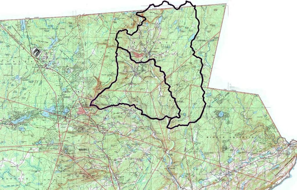
3 Watershed Area Upper Brodhead Watershed Area = 65.9 sq. miles Paradise Creek Watershed Area = 44.5 sq miles Total Combined Watershed Area = sw. miles
4 What is a Greenway? A Greenway is a protected corridor of open space. Greenways vary greatly in scale and can run through urban, suburban, and Rural areas. Greenways differ in location and function, but overall greenways strive to protect natural, cultural, and scenic resources.

5 Greenway Plan Goals Protect Natural Resources Protect Rural Character Foster Economic Prosperity Promote Public Recreation, Health and Fitness Strengthen Community Connections Expand and Enhance Scenic Byways


6 Protect Natural Resources Through sound land conservation and preservation practices the greenway can protect existing natural resources within the Watershed that will in turn: Protect Clean Water Preserve Fish and Wildlife Help Reduce Flooding Help Reduce Pollution Main Roads Streams Municipal Boundaries Conservation Areas Watershed


7 Protect Rural Character The Upper Brodhead Paradise Creek Greenway will help to preserve the rural character of the local community by: Protecting Scenic Resources Preserving Village Centers Preserving Open Space

8 Foster Economic Prosperity Tourism is one of Monroe County s largest industries. The growing popularity of outdoor recreation pursuits has created opportunities for economic growth by generating revenue from: Vacation and Weekend Lodging Dining and Shopping Recreational Activities Equipment and Sales

9 Promote Public Recreation, Health and Fitness The Upper Brodhead and Paradise Creek Greenway will offer quality opportunities for health, fitness and outdoor recreation. Hiking and Biking Fishing and Hunting Nature Study Skiing and Skating


10 Community Connections The Upper Brodhead and Paradise Creek Greenway can create opportunities for physical and visual connections to community assets such as: Public Municipal Parks, Forests & Natural Areas Private Recreation, Amusements & Resort Activities Schools, Libraries, Churches & Municipal Services Neighborhoods Village and Commercial Centers


11 Scenic Byways The Upper Brodhead and Paradise Creek Greenway Plan can expand and create new scenic byways to attract visitors for: Leisure Drives Fall Foliage Tours Bike Tours Enjoyment of Scenic Vistas
12 Pennsylvania Department of Conservation and Natural Resources Master Site Planning Process
13 Greenway Planning Process 1. Public Participation 2. Data Collection and Analysis 3. Determine Demand and Potential Use of the Greenway 4. Identify Key Organizations, Individuals and Primary Property Owners 5. Identify Issues, Opportunities and Potential Threats 6. Watershed Protection and Greenway Development Options 7. Implementation Plan
14 1.) Public Participation 21 Study Committee Members were appointed by Barrett, Price, Paradise Townships and Mount Pocono Borough to conduct the Public Participation Process including: 3 Public Meetings/Forums 6 Study Committee Meetings 15 Key Person Interviews
15 2.) Data Collection & Analysis
16 Data Collection and Analysis Existing and Proposed Greenways Land Cover Topography Recreation and Conservation Areas Streams Wetlands and Lakes Historic Sites Stream Designation Water Quality Utilities Watershed Land Ownership Brodhead & Paradise Creek Frontage Ownership


17 Existing and Proposed Greenways Proposed Greenway Existing Greenway Source: Monroe County Open Space Plan Ch7 P31

18 Land Cover Monroe County GIS Date
19 Topography

20 Recreation and Conservation Areas Monroe County GIS Date Recreation and Conservation Areas 21.3% Steam Designations Other 78.7%

21 Streams Wetlands and Lakes Monroe County GIS Date

22 Historic Sites Monroe County GIS Date

23 Stream Designation

24 Water Quality

25 Utilities Monroe County Open Space Plan Ch 7 P27

26 Land Ownership Within the Watershed Monroe County GIS Data

27 Brodhead & Paradise Creek Frontage Ownership Monroe County GIS Date

28 What is a Greenway? A Greenway is a protected corridor of open space. Greenways vary greatly in scale and can run through urban, suburban, and Rural areas. Greenways differ in location and function, but overall greenways strive to protect natural, cultural, and scenic resources.
29 THE END
Mendota Heights 2040 Comprehensive Plan Draft Vers
 4 Parks and Trails The City of Mendota Heights boasts a variety of recreational and open space opportunities. Few cities can claim access to regional trails, riverside and lakeside parks, scenic bluffs
Executive Summary Purpose of the Plan Defining Open Space and Greenways
 Executive Summary Bucks County possesses a vast array of open space resources including natural areas, parks, farmland and historic and cultural resources that contribute to a high quality of life valued
Statewide Greenways Vision
 Greenways Vision The formation of a greenways vision is based on a thorough analysis of the current state of recreation and open space in a region and the existing pressures that threaten it. Lehigh and
ELIGIBILITY CRITERIA CHECKLIST OPEN SPACE CLASSIFICATION
 THURSTON COUNTY DEVELOPMENT SERVICES OPEN SPACE TAX PROGRAM ELIGIBILITY CRITERIA CHECKLIST OPEN SPACE CLASSIFICATION Use this checklist to help you determine whether your property is eligible for open
Draft Stillwater 2030 Comprehensive Plan- Goals and Policies
 Draft Stillwater 2030 Comprehensive Plan- Goals and Policies Instructions- Review each goal and policy and discuss with group any changes, deletions for additions to the list using your groups pen. Keep
TABLE OF CONTENTS. Transportation Chapter 1 - Introduction and Purpose of Planning to 1-3. Utilities
 Chapter 1 - Introduction and Purpose of Planning... 1-1 to 1-3 Pennsylvania Municipalities Planning Code (Act 247)...1-1 Previous County Planning Activities...1-1 Objectives of the Plan...1-2 Elements
Yadkin River Greenway Feasibility Study Fact Sheet Village of Clemmons, Town of Lewisville, Town of Bermuda Run
 Fact Sheet Village of Clemmons, Town of Lewisville, Town of Bermuda Run Project Background The Yadkin River Greenway Feasibility Study is a joint project with the Village of Clemmons, the Town of Bermuda
4-Town Comprehensive Plan DRAFT 7/30/07
 4-Town Comprehensive Plan DRAFT 7/30/07 Acknowledgements ning Committee Town of Harrisburg Norman Roof Randy Nicol Town of Martinsburg Terry Thisse Paul Kelly Town of Montague Jan Bagdanowicz Wendy Perry
Planning for Waterfront Communities
 Planning for Waterfront Communities Redevelopment Ready Communities Supplemental Training Program OFFICE OF THE GREAT LAKES Waterfront Community Best Practices and Guidelines New supplemental criteria
PREVIOUS PUBLIC PARTICIPATION BRIEF October 2014
 Comprehensive Planning During the development of the county comprehensive plan, Cultivating Community: A Plan for Union County s Future from 2007 through 2009, and three concurrent multi municipal plans
Preface. Erie. Scranton. Allentown. Pittsburgh. Harrisburg. Philadelphia
 The Southern Alleghenies Region The Southern Alleghenies Region spans the Laurel Highlands and Allegheny Front in the west across the Appalachians to the east. It is comprised of Blair, Bedford, Cambria,
National Association of Conservation Districts. Kris Hoellen Vice President, Sustainable Programs The Conservation Fund September 19, 2013
 National Association of Conservation Districts Kris Hoellen Vice President, Sustainable Programs The Conservation Fund September 19, 2013 Our Mission The Conservation Fund forges partnerships to conserve
Village of Fair Haven Goals & Objectives
 Village of Fair Haven Goals & Objectives 1 Natural Environmental Quality & Aesthetics Embrace policies and programs that preserve and enhance the Village s natural resources, environment, water quality,
Improve Neighborhood Design and Reduce Non Point Source Water Pollution
 HOW TO Planning Guide Improve Neighborhood Design and Reduce Non Point Source Water Pollution This document was funded by a grant from the New Hampshire Coastal Program with funding from the National Oceanic
Sectoral workshop on Green infrastructure implementation. Multiple benefits of Green Infrastructure
 Sectoral workshop on Green infrastructure implementation Multiple benefits of Green Infrastructure Kristin Faurest Arad October 2015 Contents Green infrastructure as an integrated solution: social, ecological
GENERAL LAND USE POLICIES
 GENERAL LAND USE POLICIES The County will: GOALS AND OBJECTIVES 7.1 Fiscal Distribute the designation of land uses to balance the costs of providing public services and facilities with generating public
Conservation Development
 Acknowledgements RIDEM: Scott Millar Anthony Lachowicz-Planning and Zoning Consultant Director of Planning 1 : a creative land use technique that allows a community to guide growth to the most appropriate
METROPOLITAN COUNCIL 390 North Robert Street, St. Paul, MN Phone (651) ; TDD (651)
 ; TDD (651)") DATE: October 24, 2012 METROPOLITAN COUNCIL 390 North Robert Street, St. Paul, MN 55101 Phone (651) 602-1000; TDD (651) 291-0904 TO: Metropolitan Parks and Open Space Commission FROM: Tori Dupre, Senior
DATE: October 24, 2012 METROPOLITAN COUNCIL 390 North Robert Street, St. Paul, MN 55101 Phone (651) 602-1000; TDD (651) 291-0904 TO: Metropolitan Parks and Open Space Commission FROM: Tori Dupre, Senior
PARKS AND RECREATION
 PARKS AND RECREATION WHAT YOU WILL FIND IN THIS CHAPTER: Background information on the development of the Park, Recreation, and System Plan (PRSP). General overview of Ellensburg s parks and recreation
Asbury Chapel Subdivision Sketch Plan
 Asbury Chapel Subdivision Sketch Plan PART 1: PROJECT SUMMARY Applicant: NVR Inc. Project Size: +/- 76.13 acres Parcel Numbers: 02101112,02116101,02116112, 02116113 Current Zoning: Transitional Residential
Portage County Parks, Trails and Greenways Plan
 Portage County Parks, Trails and Greenways Plan Agenda for Local Planning Meeting Introductory Presentation Why we need a Plan Plan project goals and process Benefits Overview of local planning region
Protecting Farmland. The Future of Agriculture in Prince George s County
 Protecting Farmland As demonstrated in the previous section, farmland in Prince George s County is disappearing at a rapid pace. If the loss of farmland continues at this rate, no farmland will be left
VILLAGE & TOWN OF BERGEN: COMPREHENSIVE PLAN
 VILLAGE & TOWN OF BERGEN: COMPREHENSIVE PLAN CPC Public Hearing April 21, 2016 History 1996 Comprehensive Plan Comprehensive Plan Update Committee Consultant (LaBella Associates): December 2014 Residents
The Palisades Interstate Parkway and Henry Hudson Drive designated a New Jersey State Scenic Byway, 2005
 The Palisades Interstate Parkway and Henry Hudson Drive designated a New Jersey State Scenic Byway, 2005 What are scenic byways? How Did Scenic Byways Come About? National Scenic Byways Program Administered
6.0 Conclusions & Recommendations
 6.0 Conclusions & Recommendations 75 The research, public outreach and feasibility analysis completed for this study indicate that Trail Alternative #2 (South side of Doctors Creek) is the most comprehensive
The following principles guide the development of goals and strategies to protect and promote these amenities:
 OPEN SPACE/PARKS/TRAILS/RECREATION GOALS/STRATEGIES Cherry Hills Village is a living environment that offers low density development, open areas, public scenic vistas, public trails and public parks. This
SALISBURY TOMORROW Our Vision
 SALISBURY TOMORROW Our Vision Salisbury is committed to supporting a high quality of life and sense of community for all residents. These commitments need to be reflected in our community programs, services
Town of Peru Comprehensive Plan Executive Summary
 Town of Peru Comprehensive Plan Executive Communities that plan grow by choice, not by chance. A plan makes growth thoughtful, understandable, and predictable. A plan shows that a community is managing
Map Development 5/15/2012. New Virginia Modeling Tools
 Regional Green Infrastructure Base Map Development 5/15/2012 RRRC Land Use & Environment Committee New Virginia Modeling Tools VA Natural Landscape Assessment Forest Habitats Cultural Model Historic Resources
This page intentionally blank.
 This page intentionally blank. Parks, Recreation, and Open Space Chapter Relationship to Vision Vision Parks, Recreation and Open Space Chapter Concepts County Government. County government that is accountable
{Best Practices. Summary of Tools, Strategies and Best Practices from 11 Michigan Case Study Communities
 Case Studies Michigan Coastal Community Working Waterfronts { Summary of Tools, Strategies and from 11 Michigan Case Study Communities Table of Contents Zoning...2 Community and Stakeholder Collaboration
Growth Management: Common Value 2 of Community Character
 Growth Management: Common Value 2 of Community Character 24 Why is Growth Management a Common Value? Effective Growth Management is essential to protecting our surrounding ecosystem and reinforcing our
COMPREHENSIVE PLAN & UNIFIED DEVELOPMENT ORDINANCE
 Village of Forsyth COMPREHENSIVE PLAN & UNIFIED DEVELOPMENT ORDINANCE Community Planning #6 Prepared by: Vision Statement We envision the Forsyth Community as one which will continue to maintain a small
Chapter 5: Recreation
 Chapter 5: Recreation Introduction and Setting Recreational opportunities within Nevada County are varied, ranging from public parks with intensively used active recreational facilities, to vast tracts
E. RURAL COMMERCIAL/INDUSTRIAL PARK MODEL
 E. RURAL COMMERCIAL/INDUSTRIAL PARK MODEL 1. PURPOSE The purpose of the Rural Commerce/Industrial Park Model is to provide parameters within which a grouping of business buildings with parking, loading
RIVERFRONT REDEVELOPMENT PLAN
 RIVERFRONT REDEVELOPMENT PLAN PROJECT BACKGROUND DEVELOPMENT OPPORTUNITIES This project strives to connect St. Francisville s downtown Historic District to the Mississippi River through river tourism,
SECTION II SECTION II STATEMENT OF GOALS, OBJECTIVES, PRINCIPLES, ASSUMPTIONS, POLICIES AND STANDARDS
 STATEMENT OF GOALS, OBJECTIVES, PRINCIPLES, ASSUMPTIONS, POLICIES AND STANDARDS 1 2 STATEMENT OF GOALS, OBJECTIVES, PRINCIPLES, ASSUMPTIONS, POLICIES AND STANDARDS INTRODUCTION The New Jersey Municipal
Woodland Conservation and the Master Plan
 1 WHAT IS A MASTER PLAN? A Vision for the Future of Your Community Woodland Conservation and the Master Plan Goals Objectives Strategies 2 How Will Your Community Look? TREE PRESERVATION AND THE MASTER
SEWRPC OUTDOOR RECREATION AND OPEN SPACE PLANNING OBJECTIVES, PRINCIPLES, AND STANDARDS
 SEWRPC OUTDOOR RECREATION AND OPEN SPACE PLANNING OBJECTIVES, S, AND STANDARDS Introduction The Southeastern Wisconsin Regional Planning Commission (SEWRPC), as part of the regional park and open space
Shared Vision - Every successful
 Goals and Objectives Page 2-1 COMMUNITY CONSERVATION AND DEVELOPMENT GOALS AND OBJECTIVES Need for Goals and Objectives Shared Vision - Every successful business, organization, or individual has a plan
Pattern 7: Natural Environment
 Pattern 7: Natural Environment The landscape features of the city: the vegetation or the water, were often noted with care and with pleasure [People] were sharply aware of the few green oases in their
Greenways as an alternative to traditional infrastructure. Green Infrastructure
 Greenways as an alternative to traditional infrastructure Green Infrastructure What is a Greenway? Little (1990) - A linear open space along a natural or human made corridor. Fabos - linked corridors nature
Brodhead Watershed Conservation Plan
 Brodhead Watershed Conservation Plan January, 2002 Prepared by: Brodhead Watershed Association With: BLOSS Associates Acknowledgements The Watershed Partners were the backbone of this planning process.
A Vision for Walnut Creek
 A Vision for Walnut Creek Photo: City of Clive Walnut Creek Booklet 8 of 8 Greater Des Moines Water Trails and Greenways 1 Table of Contents Booklet 1: Water Trails Strategies and Policies Booklet 2: Beaver
CHAPTER 1 Background Information
 CHAPTER 1 Background Information Introduction Antietam Lake Park is located in Berks County, just east of the City of Reading. The 643 acre county park was assembled through several acquisitions in 2005,
Whitemarsh Township Greenway Plan
 Whitemarsh Township Greenway Plan Prepared for: Whitemarsh Township August 16, 2007 Table of Contents Table of Contents... i Introduction... 1 Study Area Setting... 2 Regional Setting... 2 Township Character...
Village Gateway at Law Park, with Memorial Plaque to Walter Law. Brick Wall along former Speyer Estate
 2.0 EXISTING CONDITIONS This chapter describes Briarcliff Manor s planning history and physical characteristics. This is necessary background for the land use recommendations in the Village Plan. 2.1 REGIONAL
Associate Superintendent. Plymouth, Minnesota
 Associate Superintendent Plymouth, Minnesota Welcome to Three Rivers Three Rivers District is a natural resources-based park system located in the suburban Minneapolis/St. Paul metro area of Minnesota
City of Chickasaw Land Use Comprehensive Plan 2030 Chapter5-Draft(2)Public review_
Public review_") Land Use Land Use refers to the activity or development characteristics of a given parcel of land. The Land Use Plan presented in the following pages, represents the City of Chickasaw s official position
Land Use Land Use refers to the activity or development characteristics of a given parcel of land. The Land Use Plan presented in the following pages, represents the City of Chickasaw s official position
Living in Albemarle County s Urban Places
 Living in Albemarle County s Urban Places ALBEMARLE COUNTY, VIRGINIA A Closer Look at Albemarle s Approach to Managing Growth and Creating Quality Urban Environments www.albemarle.org Page 2 Living in
THE LAND CONSERVANCY OF SAN LUIS OBISPO COUNTY
 THE LAND CONSERVANCY OF SAN LUIS OBISPO COUNTY WWW.LCSLO.ORG WHO WE ARE Through voluntary and collaborative measures, we work to permanently protect and enhance lands having important scenic, agricultural,
Shared History, Shared Future
 Open Space is Shared History, Shared Future Builds upon past and current regional planning: PSP Action Agenda, Vision 2040, the Cascade Agenda, and Mountains to Sound Greenway The ROSS Approach Building
Chapter 9 Community Facilities & Services Plan. Introduction. Cooperative Efforts. Monitoring of Needs
 Chapter 9 Community Facilities & Services Plan Introduction The location of key community facilities such as water, sewer, schools, parks, and roads is important to the provision of the necessary services
[Unofficial translation by Mo Laidlaw, 3 hours unpaid, not perfect. 26 October 2015.]
![[Unofficial translation by Mo Laidlaw, 3 hours unpaid, not perfect. 26 October 2015.]](/thumbs/82/86076184.jpg "[Unofficial translation by Mo Laidlaw, 3 hours unpaid, not perfect. 26 October 2015.]") [Unofficial translation by Mo Laidlaw, 3 hours unpaid, not perfect. 26 October 2015.] The land use and development plan (schéma d aménagement) is a planning document that sets out the main guidelines and
[Unofficial translation by Mo Laidlaw, 3 hours unpaid, not perfect. 26 October 2015.] The land use and development plan (schéma d aménagement) is a planning document that sets out the main guidelines and
RECREATION, OPEN SPACE AND GREENWAYS ELEMENT GOALS, OBJECTIVES, AND POLICIES
 RECREATION, OPEN SPACE AND GREENWAYS ELEMENT GOALS, OBJECTIVES, AND POLICIES GOAL R-1: DEVELOP A RECREATION, OPEN SPACE AND GREENWAYS SYSTEM AS AN INTEGRAL COMPONENT OF AN OVERALL, COUNTY-WIDE ECONOMIC
Heart of the Triad A Dynamic Plan for the Future. Steering and Technical Meeting April 27, 2006
 Heart of the Triad A Dynamic Plan for the Future Steering and Technical Meeting April 27, 2006 The Week in Review Specific Group Findings There Was Uniform Agreement the Time Was Right Growth is Imminent
Planning Academy MARCH 8, 2015
 Planning Academy MARCH 8, 2015 Overview of Growth Management in Albemarle County Comprehensive Plans, Planning Initiatives Major Milestones Key Policies History Comprehensive Plan should precede Zoning
CHAPTER 2 COMMUNITY DEVELOPMENT GOALS AND OBJECTIVES VISION FOR AMITY-EXETER-ST. LAWRENCE REGION
 CHAPTER 2 COMMUNITY DEVELOPMENT GOALS AND OBJECTIVES VISION FOR AMITY-EXETER-ST. LAWRENCE REGION The municipalities of Amity, Exeter, and St. Lawrence will actively strive to maintain and enhance the quality
BROOKHILL NEIGHBORHOOD MODEL ZONING MAP AMENDMENT PREFACE TO APPLICATION
 BROOKHILL NEIGHBORHOOD MODEL ZONING MAP AMENDMENT PREFACE TO APPLICATION June 15, 2015 Revised: August 1, 2016 I. VISION Brookhill is a proposed community based upon the principles of Albemarle County
Planning for and Managing Open Space and Natural Areas
 Planning for and Managing Open Space and Natural Areas Increasingly, development proposals in Delaware include large amounts of open space and natural areas. While open space is important as a community
Whitemarsh Comprehensive Plan Update: Housing & Land Use. Public Workshop #3: September 20, 2018
 Whitemarsh Comprehensive Plan Update: Housing & Land Use Public Workshop #3: September 20, 2018 Agenda Welcome Process Recap What We ve Heard The Plan Framework Review of Recommended Actions Land Use Housing
COMMUNITY ENVIRONMENTAL MANAGEMENT
 COMMUNITY ENVIRONMENTAL MANAGEMENT CEM HANDBOOK FOR COMMUNITY CONSERVATION PLANNING ----- Draft ----- Prepared by the CENTER FOR COMMUNITY ENVIRONMENTAL MANAGEMENT in association with the NEW YORK STATE
OPEN SPACE AND RECREATION
 OPEN SPACE AND RECREATION The Town celebrates and maintains the spectacular visual character of our Sonoran Desert setting and we value our open space, mountain views, washes, vegetation, and wildlife.
WATERFORD Plan of Preservation, Conservation and Development Supplement Part 1 - Policy Element
 WATERFORD 2012 Plan of Preservation, Conservation and Development 2015 Supplement Part 1 - Policy Element Effective June 11, 2015 2015 Plan Update GOAL To respond to the evolving land use needs and continually
Appendix D OUTDOOR RECREATION AND OPEN SPACE PLANNING OBJECTIVES, PRINCIPLES, AND STANDARDS FOR WASHINGTON COUNTY
 Appendix D OUTDOOR RECREATION AND OPEN SPACE PLANNING OBJECTIVES, S, AND FOR WASHINGTON COUNTY OBJECTIVE NO. 1 The provision of an integrated system of public -use outdoor recreation sites and related
Green Infrastructure The Indianapolis Greenways Connection
 Green Infrastructure The Indianapolis Greenways Connection Fewer things in the transportation industry today make better since than combining the needs for pedestrian and bike trails with the need to locate,
Town of Rico Three Mile Plan for Annexation
 Town of Rico Three Mile Plan for Annexation 10.20.2010 Adopted by Resolution 2010-2 Produced with funding support from the Colorado Department of Local Affairs 2 Content Guide Introduction. 3 Annexation
Preserving Our Past. Securing Our Future.
 Heritage Woods/Traffic Montrose West Intersection Springside Dr./S.R. 18Intersection Flight Memorial Dr./ S.R. 18Intersection Red Roof Inn High Density Development Ridgewood/ Cleve-Mass Intersection Ridgewood/
CHAPTER 4 FUTURE LAND USE AND URBAN SERVICES DISTRICTS
 CHAPTER 4 FUTURE LAND USE AND URBAN SERVICES DISTRICTS Introduction This chapter discusses how Benzie County should grow and change in the future. A community can grow and change in many different ways.
Riparian Buffer on the Bushkill Creek. Policies
 Riparian Buffer on the Bushkill Creek Riparian buffers provide numerous benefits to landowners and the community by protecting groundwater recharge areas, providing flood control, providing stormwater
Comprehensive Plan Introduction Bristol, TN
 COMMUNITY MEETING #3 PROGRESS REPORT: Kick Off meeting with Staff Kick Off Meeting with Planning Commission and City Council Kick Off Meeting with Community Advisory Committee (CAC) 10-12 Individual and
KEY FINDINGS. Community Engagement + Research
 PROJECT OVERVIEW PROJECT OVERVIEW PROJECT OVERVIEW KEY FINDINGS Community Engagement + Research Community Engagement Community Issues Workshop Steering Committee Workshop City Council/Planning Workshop
Turkey Creek Streamway Corridor
 Turkey Creek Streamway Corridor Turkey Creek Corridor Overview History Watershed Corridor Inventory Coalition Corridor Plan Stages of Development Benefits Funding Turkey Creek History Kansas and Missouri
The only significant recreation deficiency in Conway is the absence of an integrated greenway and multipurpose trail system.
 CHAPTER 6 RECREATION 1. Introduction This recreation chapter is prepared in compliance with recently revised state statutes dealing with the completion of municipal master plans [RSA 674:2 III (F)]. This
Lake O the Pines Master Plan Revision Public Information Meeting April 25 & 27, 2017
 Lake O the Pines Master Plan Revision Public Information Meeting April 25 & 27, 2017 Presented By Matthew Like, Lake Manager U.S. Army Corps of Engineers Fort Worth District US Army Corps of Engineers
Green Infrastructure. by Karen Engel, NYS DEC. NYS Department of Environmental Conservation
 Green Infrastructure by Karen Engel, NYS DEC What is Green Infrastructure? For some it s all about water Green Infrastructure techniques use soils and vegetation to infiltrate, evapotranspirate, and/or
LRPC VISION GOALS-OBJECTIVES-STRATEGIES
 ENVIRONMENT: Wooded surroundings, meandering creeks and natural beauty allow residents to enjoy the benefits of living in a low-density village setting with quick and easy access to the offerings of the
HOT SPRINGS COMPREHENSIVE PLAN OUTLINE
 HOT SPRINGS COMPREHENSIVE PLAN OUTLINE 7/28/2015 Draft outline - Hot Springs Comprehensive Plan Draft outline of topics to be discussed at public hearings and in planning sessions. Order and topics and
Resilience on the Great Lakes: A Tale of Two Counties
 Resilience on the Great Lakes: A Tale of Two Counties James C. Schwab, AICP Manager, APA Hazards Planning Research Center ASFPM No Adverse Impacts Seminar Milwaukee August 19, 2014 Why this approach? Comparisons
Appendix I. Appendix I - CURRENT CONDITIONS & CONCEPTS. Appendix I - CURRENT CONDITIONS & CONCEPTS
 Appendix I - CURRENT CONDITIONS & CONCEPTS Appendix I - CURRENT CONDITIONS & CONCEPTS Appendix I Existing Regional Study Boundary and Zoning Susceptible To Change Existing Condition and Approved Plans
The Floyds Fork Area Study A Framework for Growth
 The Floyds Fork Area Study A Framework for Growth Planning Committee 7/8/10 City of Parks 2 Growth Pattern REZONINGS (1976 2007) 1976 1983 1984 1991 1992 1999 2000 2007 1976-1983 3 Growth Pattern REZONINGS
The Economic Value of Protected Open Space in Southeastern Pennsylvania
 The Economic Value of Protected Open Space in Southeastern Pennsylvania SUMMARY REPORT Looking at the landscape. 200,000+ Acres Protected in Southeastern Pennsylvania. 30% Privately Owned or Eased Lands
The Trust for Public Land. in Minnesota
 The Trust for Public Land in Minnesota Protecting Minnesota s Natural Legacy In Minnesota, The Trust for Public Land (TPL) is protecting strategic land and water resources for people to enjoy as parks,
City of Missoula and Missoula County Open Space Planning Open House
 City of Missoula and Missoula County Open Space Planning Open House FEBRUARY 6, 2018 The following slides contain the display board content from the open house. Please use boards to answer questions in
Secrest Short Cut and Monroe Expressway Small Area Plan AUGUST 29, 2018
 Secrest Short Cut and Monroe Expressway Small Area Plan AUGUST 29, 2018 Background and Process Monroe Expressway will be open by the end of 2018 Union County and Indian Trail identified a need to revisit
Chapter Two Planning Issues
 Chapter Two Planning Issues Introduction The development of goals, objectives and policies to address the future of the Cass County community requires a recognition of the primary planning issues present.
Master Plan for Preservation and Scenic Conservation (1995)
") 3.2 Master Plan for Preservation and Scenic Conservation (1995) The Master Plan for Preservation and Scenic Conservation was developed under the direction of the Guilford Preservation Alliance in the 1980s
3.2 Master Plan for Preservation and Scenic Conservation (1995) The Master Plan for Preservation and Scenic Conservation was developed under the direction of the Guilford Preservation Alliance in the 1980s
Lewisville Lake Master Plan Revision Public Information Meeting May 2 & 4, 2017
 Lewisville Lake Master Plan Revision Public Information Meeting May 2 & 4, 2017 Presented By Rob Jordan Lake Manager U.S. Army Corps of Engineers Fort Worth District US Army Corps of Engineers Purpose
A citizen s guide to the. Comprehensive Plan. City of Lakeville, Minnesota 1
 A citizen s guide to the Comprehensive Plan 2008 City of Lakeville, Minnesota 1 Introduction The City of Lakeville completed an update of its Comprehensive Plan in 2008. A comprehensive plan is a tool
Putting the Pieces Together
 Putting the Pieces Together A guided tour of the St Croix Valley's land and water resources A Guided View from the River: What are the challenges and obstacles your community is facing? 1 Site 2 Buk and
Chapter 13: Implementation Plan
 Implementation A. Introduction The Implementation Plan, in table form on the following pages, provides a summary of all the Action Items recommended in Chapters 2 through 12. The table also indicates which
Rural Conservation. Rural Conservation. Moving Forward ~ Planning Ahead. Introduction
 Introduction Minnehaha County expresses at least two very different styles of character. The City of Sioux Falls provides a strong urban atmosphere because of its size and regional status, and the unincorporated
Sorted citizen input comments in review of Blount County plans July, August, and September 2007
 Sorted citizen input comments in review of Blount County plans July, August, and September 2007 The following presents sorted citizen input comments from three sessions held in July, August and September
The Mystic River Greenway
 The Mystic River Greenway City of Medford November 30, 2006 MIT Department of Urban Studies and Planning The Mystic River Greenway A greenway is a regional network that connects: Open Space Visibility,
Conservation Corridor Planning and Green Infrastructure Themes
 Conservation Corridor Planning and Green Infrastructure Themes Prepared by the Green Infrastructure Center Inc. and the Northern Virginia Regional Commission February 22, 2011 Brief Overview Project Background
OVERMOUNTAIN VICTORY TRAIL BURKE CALDELL CORRIDOR FEASIBLITY STUDY REQUEST FOR QUALIFICATIONS CALDWELL COUNTY PATHWAYS
 OVERMOUNTAIN VICTORY TRAIL BURKE CALDELL CORRIDOR FEASIBLITY STUDY REQUEST FOR QUALIFICATIONS CALDWELL COUNTY PATHWAYS Caldwell County Pathways along with our co-partners City of Lenoir, Town of Gamewell,
Parks, Open Space and Trails
 Introduction Parks have often been referred as the lungs of our cities, cleansing the air of pollutants and particulate matter. Parks are also gathering places for families and community. They offer spaces
RECREATION AND OPEN SPACE ELEMENT GOALS, OBJECTIVES, AND POLICIES
 RECREATION AND OPEN SPACE ELEMENT GOALS, OBJECTIVES, AND POLICIES Goal 7 To provide park facilities, recreation programs, and open space resources that are safe, adequate, and accessible to all City residents,
Municipal Plan*Assessment
 Municipal Plan*Assessment This tool was developed to assist in reviewing municipal master plans and in determining if these plans are consistent with smart growth principles, neighboring municipal plans,
Great Rivers Greenway CLEAN GREEN CONNEC TED T RAILS
 Great Rivers CLEAN GREEN CONNEC TED T RAILS Great Rivers (GRG) was established in 2000 to create a clean, green, connected St. Louis region. Today, many new and exciting projects demonstrate the social,