III. PROJECT DESCRIPTION
|
|
|
- Piers Jacobs
- 5 years ago
- Views:
Transcription
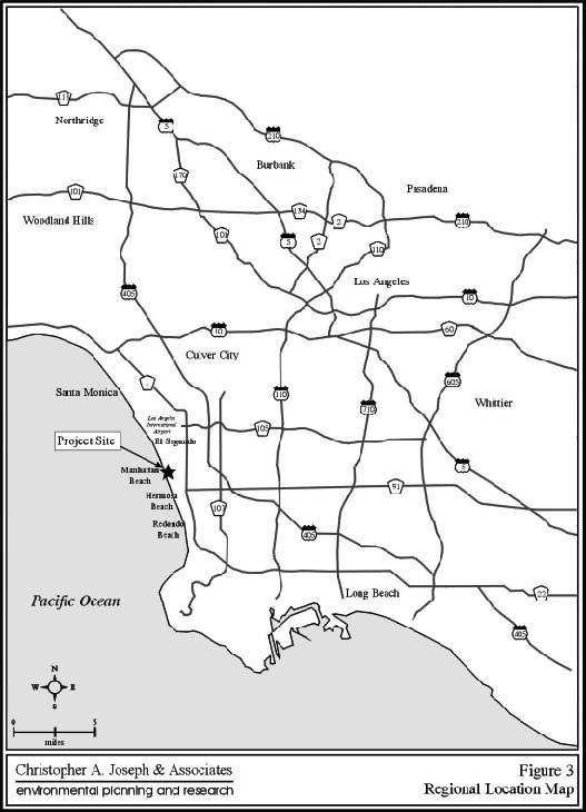
1 III. PROJECT DESCRIPTION LOCATION AND BOUNDARIES The City of Manhattan Beach is located in the South Bay region of Los Angeles County, California, approximately 2 miles south of the Los Angeles International Airport (LAX). Manhattan Beach is bounded by the cities of El Segundo to the north, Hermosa Beach to the south, Hawthorne and Redondo Beach to the east (see Figure 3, Regional Location Map, on page 30). The project site is located at the corner of Manhattan Beach Boulevard and Valley Drive, which provides an important gateway into the City s Downtown commercial area. Within the downtown area, the project site incorporates a portion of the existing Civic Center site and the former Metlox Pottery site. The Civic Center site occupies approximately 4.77 acres (or 208,200 square feet) and includes the Police and Fire Department buildings, the Public Library building, and the Civic Center surface parking lot. 3 No changes to the City Hall building are proposed under this proposal and is therefore, not considered a part of this project. The former Metlox Pottery site occupies roughly 3.23 acres (or 141,121 square feet), including the entire area from Manhattan Beach Boulevard, extending just beyond 13 th Street between Valley Drive and Morningside Drive, excluding the H20 property at the corner of Manhattan Beach Boulevard and Morningside Drive. 4 Altogether, the entire project site consists of approximately 8 acres (or 349,321 square feet). The boundaries of the entire project site are generally defined by 15th Street on the north, Valley Drive on the east, Manhattan Beach Boulevard on the south, and Highland Avenue and Morningside Drive and on the west. The project s boundaries are depicted in Figure 4, Vicinity Map, on page 31. PROJECT CHARACTERISTICS The proposed consists of a partial redevelopment of the Civic Center site including the demolition and reconstruction of the Police and Fire Department facilities and Public 3 The lot area for the Civic Center site is based on area calculations from The City of Manhattan Beach Topographic Map (Map Sheets 12 and 8), Public Works Department, City of Manhattan Beach, California (scale 1 =100 ). This area calculation excludes the City Hall building footprint area. 4 The buildable lot area for the Metlox property is approximately 95,700 square feet or 2.19 acres. The builbable lot area does not include public rights of way (i.e., the 13 th Street dedication, alleys, sidewalks, etc.). Draft Environmental Impact Report (SCH # ) Page 29
2

3
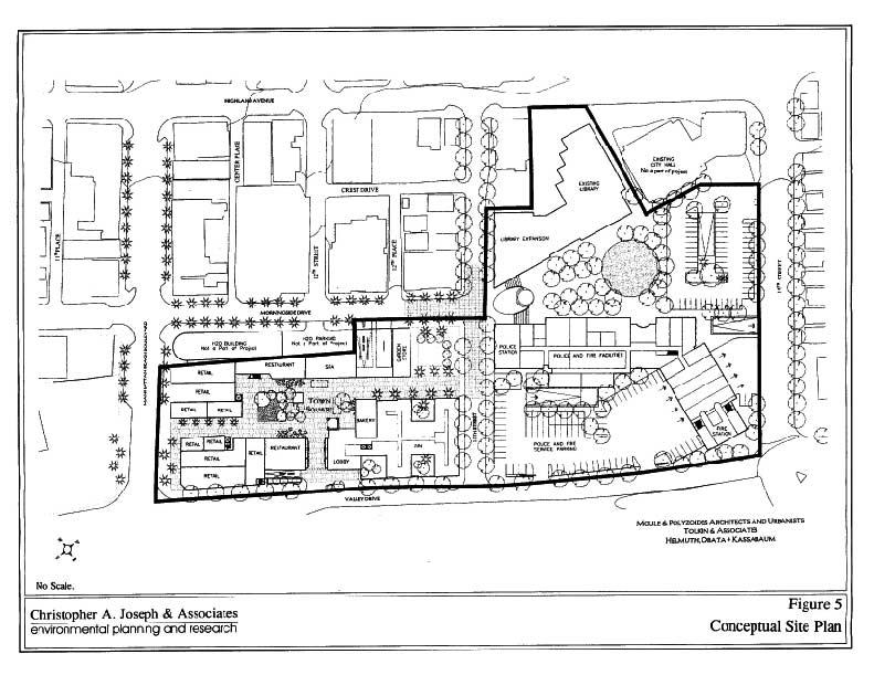
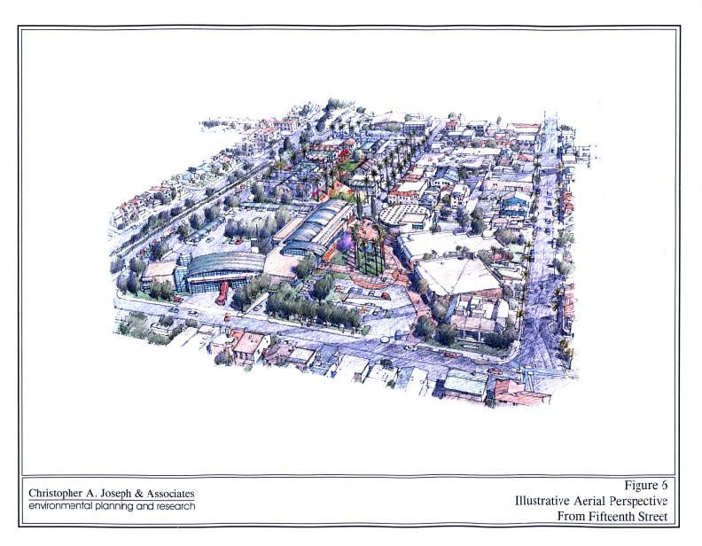
4 Library Building and the new development of an adjacent mixed-use commercial project (i.e., Metlox Development). The two sites are contiguously located (north/south) and provide an opportunity to integrate the public and private developments into a single project. The schematic ground floor plan for the proposed project is depicted in Figure 5, Conceptual Site Plan, on page 33. Civic Center / Public Safety Facilities The Civic Center portion of the project will involve a complete demolition and reconstruction of the existing Police and Fire Department Facilities. Due to the age and condition of the existing structures, the Fire Department building (10,568 square feet) and Police Department building (20,000 square feet) will be entirely demolished and reconstructed on-site. The facilities are proposed to be replaced with a two-level (one level below grade), approximately 57,000 square foot combined Police and Fire Department public safety facility incorporating all administrative and operational functions of these departments. The net increase in developed floor area over existing conditions will be approximately 26,432 square feet. The proposed structure is intended to accommodate the spatial and modernization needs of both departments and will not involve any staffing or personnel increases. The Civic Center also includes reconstruction of the existing Public Library building. The existing Public Library (12,100 square feet) will either be added on to or demolished and reconstructed with a new Public Library and Cultural Arts Center. Upon completion, the proposed Library and Cultural Arts Center will consist of an approximate 40,000 square foot structure with roughly 30,000 square feet for library space and 10,000 square feet for a 99-seat Cultural Arts Center. The Library will contain reference materials and periodicals for children through teens to adults, meeting and reading rooms, and restrooms for the community and offices for staff. The Cultural Arts Center will contain a stage for live community performances, dressing rooms, lobby, offices, kitchenette, restrooms, and exhibition space. A conceptual rendering of the Civic Center site is depicted in Figure 6, Illustrative Aerial Perspective From 15 th Street, on page 34. It is important to note that Figure 6 represents a conceptual image of the project design features, and the architectural features are not exact. This image is only intended to provide a visual concept of the site plan design. Draft Environmental Impact Report (SCH # ) Page 32
5
6
7 Table 2 Project Summary Of Proposed Uses Existing Development Proposed Uses (sq. ft.) Civic Center Site Fire Department 10,568 Police Department 20,000 Proposed Development (sq. ft.) Net Increase (sq. ft.) 57,000 (combined) 26,432 Public Library 12,100 30,000 17,900 Cultural Arts Center 0 10,000 10,000 Sub-Total 42,668 97,000 54,332 Metlox Commercial Development Site Restaurants N/A 6,400 6,400 Retail (misc.) N/A 18,500 18,500 Bakery N/A 2,168 2,168 Nursery Garden Store N/A 2,500 2,500 Commercial Office N/A 26,411 26,411 Day Spa N/A 3,000 3,000 Inn (+/-40 rooms) N/A 30,780 30,780 Sub-Total 0 89,759 89,759 TOTAL 186, ,091 Metlox The Metlox project consists of a mixed-use commercial development with subterranean parking, including some above-grade surface parking on the proposed 13 th Street extension. The total floor area proposed is approximately 90,000 square feet comprised of retail, restaurant, a 40-room Bed and Breakfast lodging component, and office uses. The preliminary design envisions one- and two-story buildings oriented around the streets, outdoor plazas (paseos) and a Town Square. Some of the identified feature elements of the proposal include a Gateway Plaza, a Town Square, a Lookout Tower, outdoor dining and a bed and breakfast style inn. As identified in the Design and Development Proposal submitted to the City by the Tolkin Group, the vision for the development of the Metlox block is to create a natural extension of Downtown Manhattan Beach while sensitively making the transition from commercial uses to the adjoining residential and Draft Environmental Impact Report (SCH # ) Page 35
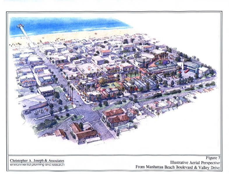
8 Civic Center uses. The Metlox development is seeking to provide a mix of local serving uses that will compliment the existing Downtown uses. Approximately 30,000 square feet of the Metlox area is proposed to be devoted to public open space. Such space will include the Gateway Plaza, the Town Square, paseos and a sculpture garden. The Town Square will include a Lookout Tower element to offer public views of the pier, beach, ocean and other local landmarks in the Downtown area. An additional open space courtyard is proposed as a garden area for the proposed bed and breakfast inn. An important aspect of this project is the pedestrian linkage between the Metlox Development and the Civic Center. Pedestrian circulation is designed to flow between the two sites providing a strong integration of the different land uses. Pedestrian circulation within the Metlox Development is centered around a Town Square. This public space may have a pre-approved set of activities that could be programmed for the Town Square on a regular basis. Pedestrian circulation around the site will be provided by sidewalks located contiguous to the perimeter streets (Valley Drive, Manhattan Beach Boulevard, Morningside Drive and 13th Street). A conceptual rendering of the Metlox and Civic Center site is depicted in Figure 7 on page 37. It is important to note that Figure 7 represents a conceptual image of the project design features and the architectural features are not exact. This image is only intended to provide a visual concept of the site plan design. Town Square Programming The Metlox development will incorporate a Town Square atmosphere to provide a vibrant, interesting, interactive place for residents of Manhattan Beach to congregate, experience culture and have fun. This public space would have a pre-approved set of activities that could be programmed on the Town Square on a regular basis. The Town Square is anticipated to include decorative hardscape, landscaping (including trees and grass) fountains, a play area, public art, street furniture (including benches and tables, and chess or checkerboard sets). Possible activities and uses for the Town Square may include: Patio Dining for Restaurants. Estimated to be approximately 600 sq. ft. per each of two restaurants, or 1,200 sq. ft. In addition, the Bakery and Ice Cream store will have approximately 300 sq. ft. each, or 600 sq. ft. of outside seating for their customers. Draft Environmental Impact Report (SCH # ) Page 36
9
10 Live Music and Performance on the Square. Music would likely include light Jazz, Classical, Swing or World Music during weekend day and evening hours; performance might include poetry and readings. Music would likely be performed without a stage or in some less frequent instances with a moveable temporary stage. Activities would be seasonal, depending on weather conditions and would most likely occur on weekends and on Friday evenings. Children s Story-Time Readings on the Square. Readings would likely be performed without a stage or in some less frequent instances with a moveable temporary stage. Activities would be seasonal, depending on weather conditions and would most likely occur on weekends, but may include some weekday mornings. School Performances. Such activities would include student plays and music performances which would be performed either without a stage or with a moveable temporary stage. Activities would be seasonal, depending on weather conditions and would most likely occur on weekday afternoons and evenings, and weekends. Street Performers/Clowns/Face Painting on the Square. Activities would likely be performed without a stage. Activities would be seasonal, depending on weather conditions and would most likely occur on weekends only. Farmer s Market. A Farmer s Market might include arts and crafts in addition to typical fresh fruits and vegetables, cheeses, fish, meat and poultry. Activities would be seasonal, depending on weather conditions and would most likely occur one day per week, which day would be selected in conjunction with downtown merchants. Parking and Vehicular Access. The proposed parking will serve both the Civic Center and Metlox developments and may be designed to provide surplus parking for the downtown area. This opportunity to provide shared parking between the public and private components is a major consideration in the proposed design. The Civic Center functions, normally occurring between 8 a.m. to 5 p.m. (except for 24 hour-a-day public safety functions), provides an opportunity to allow usage of Civic Center parking facilities after work hours and on weekends. This is similar to the current arrangement at the Civic Center, which opens employee parking to the general public after 5 p.m. Civic Center Access to public parking will be provided via 15 th Street and one location off of Valley Drive. The public driveway at 15 th Street, adjacent to the City Hall Building, will provide access to surface parking, as well as access to below grade parking via a driveway ramp located within the interior of the surface parking lot. An additional subterranean parking driveway will be provided on 15 th Street Draft Environmental Impact Report (SCH # ) Page 38
11 adjacent to the proposed Public Safety Facility for secured parking. The subterranean level will provide 116 secure parking spaces for Police/Fire functions and 87 spaces for Civic Center public and staff. The on-grade parking provides 61 secure spaces for Police/Fire and 86 spaces for Civic Center public and staff parking. The total number of spaces provided for the Civic Center is 350 (203 subterranean and 147 on-grade). Metlox The Metlox Development will include the code-required parking based on a shared use parking demand analysis. Required parking will be provided by a subterranean parking garage as well as surface parking. It is estimated that a total of 212 spaces will be required. Access driveways to the parking garage will be provided via Morningside Drive and Valley Drive. Service and delivery vehicles will be able to access the site from Valley Drive, 13 th Street, and Morningside Drive. Morningside Drive between Manhattan Beach Boulevard and 13 th Street is proposed to be restricted to a one-way street to allow for northward bound traffic only to alleviate congestion at the intersection of Morningside Drive and Manhattan Beach Boulevard. Valley Drive is currently a one way street in the vicinity of the project site. The project includes a proposal to create a two-way thoroughfare on Valley Drive between 15 th Street and 13 th Street to alleviate congestion at the intersection of Valley Drive and Manhattan Beach Boulevard. Valley Drive currently provides two southbound only lanes in this vicinity. The project also includes the extension of 13th Street for vehicular traffic to provide through vehicular access from Highland Avenue to Valley Drive. This extension will include approximately 20 on-street parking spaces. STATEMENT OF PROJECT OBJECTIVES As addressed above in the summary of on site uses, the current Police and Fire Department Facilities and Public Library building are considered to be overcrowded and functionally deficient. The proposed project provides an opportunity to integrate the two sites in a way that will create a small town community-oriented environment while at the same time improving the economic viability of the Downtown area through utilization of an underutilized property. As such, the following objectives have been identified for the project: To provide an introduction and gateway to the Downtown area; To replace undersized, functionally deficient buildings and to increase operational effectiveness of the Civic Center Public Safety Facilities; To replace a previous industrial use (the Metlox Potteries Plant), with a low-scale commercial development, which is compatible with the existing Downtown commercial area; Draft Environmental Impact Report (SCH # ) Page 39
12 To integrate the City of Manhattan Beach Civic Center with a low scale-community oriented commercial development; To provide a vibrant, interesting, interactive place for residents of Manhattan Beach to congregate, experience culture and have fun; To develop a Public Safety Facility, which houses and coordinates the activities of the police and fire departments in one facility; To incorporate open space areas (such as plazas and courtyards) and landscaping to the maximum extent feasible; To promote strong integration with the remainder of downtown including pedestrian orientation, a public plaza and/or other public uses; To integrate public parking at the site and promote shared parking operations between the two sites, as appropriate; To keep new commercial development at a low-scale and is architecturally compatible with the Downtown area; and To provide a mix of unique local serving commercial tenants who will compliment and not compete with, the existing Downtown uses, and; REQUESTED DISCRETIONARY ACTIONS The proposed project will require discretionary approval by the City of Manhattan Beach City Council and the City Planning Commission. The project would undergo one of the following discretionary plan approval processes: Development Agreement, plus! a local coastal permit, and! a height variance for the tower element; or Master Land Use Permit, plus! a local coastal permit, and! a height variance for the tower element. Draft Environmental Impact Report (SCH # ) Page 40
13 REVIEWING AGENCIES State Agencies The Governor s Office of Planning and Research has identified the agencies listed below as potential responsible agencies for the proposed project. As such, each of the agencies listed below have been notified that an EIR is being prepared for this project and have been requested to provide comments and feedback on the project, as applicable, with regards to their regulatory authority. Each of the following agencies will receive a copy of the Draft EIR for administrative review during the public review period. California Department of Transportation-Caltrans District 7; California Department of Fish and Game; Regional Water Quality Control Board, Los Angeles Region 4; The Resources Agency; California Coastal Commission; Department of Conservation; Department of Parks and Recreation, Resource Management Division; Native American Heritage Commission; and State Lands Commission; California Highway Patrol, Office of Special Projects. Regional Agencies The following regional agencies listed below have been identified as having legal jurisdiction over all or part of the proposed project. The agencies listed below have been requested to provide feedback on the project with regards to their respective legal authority. Each of the following agencies will receive a copy of the Draft EIR for administrative review during the public review period: County Sanitation Districts of Los Angeles County; and South Coast Air Quality Management District. Local Agencies The local agencies listed below have been identified as having legal jurisdiction over all or part of the proposed project. The agencies listed below have been requested to provide feedback on the project Draft Environmental Impact Report (SCH # ) Page 41
14 with regards to their respective legal authority. Each of the following agencies will receive a copy of the Draft EIR for administrative review during the public review period. City of Manhattan Beach Police Department; City of Manhattan Beach Fire Department; City of Manhattan Beach Public Works Department; and City of Manhattan Beach Community Development Department. Draft Environmental Impact Report (SCH # ) Page 42
SUBJECT: PREDEVELOPMENT PLAN REVIEW OF PROJECT LOCATED AT E. COLORADO BOULEVARD (PASEO COLORADO)
") TO: FROM: Honorable Mayor and City Council Planning & Community Development Department SUBJECT: PREDEVELOPMENT PLAN REVIEW OF PROJECT LOCATED AT 260-400 E. COLORADO BOULEVARD (PASEO COLORADO) RECOMMENDATION:
TO: FROM: Honorable Mayor and City Council Planning & Community Development Department SUBJECT: PREDEVELOPMENT PLAN REVIEW OF PROJECT LOCATED AT 260-400 E. COLORADO BOULEVARD (PASEO COLORADO) RECOMMENDATION:
PC RESOLUTION NO ARCHITECTURAL CONTROL (AC)
") PC RESOLUTION NO. 16-07-26- ARCHITECTURAL CONTROL (AC) 15-035 A RESOLUTION OF THE PLANNING COMMISSION OF THE CITY OF SAN JUAN CAPISTRANO, CALIFORNIA APPROVING ARCHITECTURAL CONTROL (AC) 15-035, INN AT
PC RESOLUTION NO. 16-07-26- ARCHITECTURAL CONTROL (AC) 15-035 A RESOLUTION OF THE PLANNING COMMISSION OF THE CITY OF SAN JUAN CAPISTRANO, CALIFORNIA APPROVING ARCHITECTURAL CONTROL (AC) 15-035, INN AT
City of Farmington. Downtown Plan. Amendment to the 1998 Master Plan Adopted October 11, 2004
 City of Farmington Amendment to the 1998 Master Plan Adopted October 11, 2004 Introduction Planning Background 1 Scope and Components of the Plan Amendment 2 Concept Introduction 3 Plan Concepts 3 Conceptual
2. INTRODUCTION 2.1 AUTHORITY 2.2 PURPOSE AND INTENT 2.3 SITE LOCATION
 2. INTRODUCTION 2.1 AUTHORITY The City of Gardena initiated and prepared the Artesia Corridor Specific Plan pursuant to the provisions of California Government Code, Title 7, Division 1, Chapter 3, Article
Millbrae TOD #2 Project Analysis
 Millbrae TOD #2 Project Analysis Project Description A Site Development Permit and Conditional Use Permit are proposed to allow for a mixed-use transitoriented development on approximately 9 Acres located
2.0 PROJECT DESCRIPTION
 2.0 PROJECT DESCRIPTION The proposed project involves the redevelopment of an approximately 6.3-acre site in the City of Long Beach with a mixed-use village center project. This section describes the project
II. PROJECT DESCRIPTION
 II. PROJECT DESCRIPTION A. PROJECT APPLICANT The project applicant is the J.H. Snyder Company located at 5757 Wilshire Boulevard, Penthouse 20, in Los Angeles, CA 90036. B. PROJECT LOCATION The project
Policies and Code Intent Sections Related to Town Center
 Policies and Code Intent Sections Related to Town Center The Town Center Vision is scattered throughout the Comprehensive Plan, development code and the 1994 Town Center Plan. What follows are sections
Wadsworth Boulevard S TAT I O N A R E A P L A N
 Wadsworth Boulevard S TAT I O N A R E A P L A N City of Lakewood Adopted November, 2006 The Vision The City of Lakewood s overall vision is to transform the area around the light rail station into a mixed-use
Pedestrian and Bike Bridge LOGO
 6.2.2 Pedestrian and Bike Bridge The proposed pedestrian and bike crossing re-envisions the existing bridge at Pismo Creek on Cypress Street. The bridge is currently underutilized by vehicular through
Sheridan Boulevard S TAT I O N A R E A P L A N S H E R I D A N B O U L E VA R D S TAT I O N A R E A P L A N
 Sheridan Boulevard S TAT I O N A R E A P L A N 1 City of Lakewood Adopted November, 2006 S H E R I D A N B O U L E VA R D S TAT I O N A R E A P L A N The Vision The City of Lakewood s overall vision is
- INVITATION - COURTESY INFORMATIONAL MEETING
 - INVITATION - COURTESY INFORMATIONAL MEETING Hosted by the Property Owner and Project Developer CAMELLIA COURT DEVELOPMENT WEDNESDAY, JANUARY 25, 2017, 7:00 9:00 P.M. BLOY CENTER 1441 S. BENITO AVE, ALHAMBRA,
NOTICE OF AVAILABILITY (NOA) OF A DRAFT ENVIRONMENTAL IMPACT REPORT AND NOTICE OF PUBLIC HEARING 2190 Shattuck Avenue Mixed-Use Project
 OF A DRAFT ENVIRONMENTAL IMPACT REPORT AND NOTICE OF PUBLIC HEARING 2190 Shattuck Avenue Mixed-Use Project") Planning and Development Department Land Use Planning Division NOTICE OF AVAILABILITY (NOA) OF A DRAFT ENVIRONMENTAL IMPACT REPORT AND NOTICE OF PUBLIC HEARING 2190 Shattuck Avenue Mixed-Use Project Notice
Planning and Development Department Land Use Planning Division NOTICE OF AVAILABILITY (NOA) OF A DRAFT ENVIRONMENTAL IMPACT REPORT AND NOTICE OF PUBLIC HEARING 2190 Shattuck Avenue Mixed-Use Project Notice
Division of Land / Environmental Review. Volume I FINAL ENVIRONMENTAL IMPACT REPORT WEST LOS ANGELES COMMUNITY PLAN AREA
 Division of Land / Environmental Review City Hall 200 N. Spring Street, Room 750 Los Angeles, CA 90012 Volume I FINAL ENVIRONMENTAL IMPACT REPORT ENV-2006-1914-EIR State Clearinghouse No. 2006061096 WEST
PINE CURVE REZONING. BACKGROUND Purchased as two parcels in 2001 and 2002
 BACKGROUND Purchased as two parcels in 2001 and 2002 WHAT THE PROJECT IS AND IS NOT A Rezoning establishes the land use standards for Annexed and Zoned Greater Downtown District Historic Center September
SPECIFIC PLAN Requirements
 CITY OF LANCASTER PLANNING DEPARTMENT 44933 Fern Avenue, Lancaster, California 93534 (661) 723-6100 SPECIFIC PLAN Requirements Purpose The purpose of a specific plan is to provide for the logical development
Buildings may be set back to create small plazas provided that these setbacks do not substantially disrupt the street wall s continuity.
 6-22 Community Design Street Walls and Street-front Setbacks The siting of buildings will play a critical role in establishing the character and sense of place for the District. Siting buildings at the
2.0 THE PLATINUM TRIANGLE VISION
 2.0 THE PLATINUM TRIANGLE VISION The envisions an exciting future for the area surrounding Angel Stadium of Anaheim, the Honda Center and The Grove of Anaheim. 2.1 Planning Principles In order to further
This Review Is Divided Into Two Phases:
 Semiahmoo Town Centre Review The purpose of this review: To review the Semiahmoo Town Centre Concept Plan, originally approved in 1993, to ensure that this centre will continue to serve the needs of South
AMEND DMENT H HOSPITAL
 AMEND DMENT TO LAND USE PLAN ELEMENT VILLAGE OF RIDGEWOOD MASTER PLAN H HOSPITAL ZONE DISTRICT Village of Ridgewood Planning Board February 28, 2014with technical revisions from June 9, 2014 Planning Board
Lehigh Acres Land Development Regulations Community Planning Project
 Lehigh Acres Land Development Regulations Planning Effort Summary In July, 2010 Commissioner Frank Mann invited the Lehigh Acres community to start discussing how to achieve their recently adopted community
Downtown / Ballough Road Redevelopment Board
 Agenda Item 5 CONDITIONAL USE DEV2014-095 Pai in the Sky Downtown / Ballough Road Redevelopment Board Staff Report TO: Downtown / Ballough Road Board Members FROM: Jason Jeffries, Project Manager DATE:
Call to Artists Public Art for Los Angeles Metro Stations
 Conceptual Design for Call to Artists Public Art for Los Angeles Metro Stations Artesia Transit Center Union Station/Patsaouras Transit Plaza Los Angeles County Metropolitan Transportation Authority February
DRAFT. 10% Common Open Space
 % OF CHARLOTTE IS CATEGORIZED AS A. LAND USES : Placeholder map displaying location of Place Type GOALS: Accommodate XX% of future growth. Provide a concentration of primarily commercial and civic activity
Clairtrell Area Context Plan
 Clairtrell Area Context Plan March 2005 Urban Development Services City Planning Contents 1. Introduction... 4 2. Development Structure... 6 2.1 Streets... 7 2.1.1 Sheppard Avenue and Bayview Avenue...
3.0 Project Description
 3.0 Project Description 3.0 PROJECT DESCRIPTION 3.1 PROJECT LOCATION AND SETTING PROJECT LOCATION The proposed Downtown Lancaster Specific Plan Project (project) is located in the City of Lancaster, California.
SECTION 3: PROJECT DESCRIPTION
 San Ramon City Center - City of San Ramon Draft Subsequent EIR Project Description SECTION 3: PROJECT DESCRIPTION This section describes the proposed San Ramon City Center Project (proposed project) that
Construction and Landscaping on Public Property
 Construction and Landscaping on Public Property City of Manhattan Beach Community Development Department 1400 Highland Avenue 310-802-5504 www.citymb.info January, 2004 Construction and Landscaping on
Workshop 3. City of Burlington Waterfront Hotel Planning Study. September 14, The Planning Partnership
 Workshop 3 City of Burlington Waterfront Hotel Planning Study September 14, 2017 The Planning Partnership The Waterfront Hotel Planning Study 01 The Brant & Lakeshore Planning Study will establish a Strategic
Table of Contents. Elm Avenue Improvement Plan City of Waco, Texas. Introduction 1. Existing Context 1 Figure 1 2.
 Table of Contents Introduction 1 Existing Context 1 Figure 1 2 Plan Guidelines 3 Future Urban Form 4 The West-End 4 Main Street 6 The East-End 7 Figure 2 9 Public Improvement Recommendations 7 General
PINE CURVE REZONING. Property does not meet criteria for open space preservation and is not a candidate for a park
 PINE CURVE REZONING BACKGROUND Purchased as two parcels in 2001 and 2002 Annexed and Zoned Greater Downtown District Historic Center September 25, 2002 and October 7, 2002 WHAT THE PROJECT IS AND IS NOT
Welcome! to Keller Town Hall
 Welcome! to Keller Town Hall Keller Town Center Planning a New Downtown What is Keller Town Center? A new, growing downtown district planned as an urban village A combination of retail and office spaces,
Town Center (part of the Comprehensive Plan)
") Town Center (part of the Comprehensive Plan) Mercer Island Town Center Looking North (2014) In 1994, a year-long process culminated in a set of design guidelines and code requirements for the Town Center
Town Center (part of the Comprehensive Plan) Mercer Island Town Center Looking North (2014) In 1994, a year-long process culminated in a set of design guidelines and code requirements for the Town Center
FLORIN ROAD CORRIDOR Site Plan and Design Review Guidelines Checklist
 FLORIN ROAD CORRIDOR Site Plan and Design Review Guidelines Checklist Applicant s Name: Project Address: Phone: Email: Applicant shall fill out the design guidelines checklist for all guidelines applicable
SFMTA PHELAN LOOP AND PUBLIC PLAZA PHELAN OCEAN AVENUE
 SFMTA Municipal Transportation Agency Image: a bus in front of the Palace of the Legion of honor SFMTA PHELAN LOOP AND PUBLIC PLAZA PHELAN AVENUE @ OCEAN AVENUE Community Meeting May 23, 2012 San Francisco,
City of Hermosa Beach Administrative Policy #
 City of Hermosa Beach Administrative Policy # SUBJECT: Living Streets Policy Date: Approved by: City Council Authority: Public Works Department & Community Development Department Mayor, PURPOSE The City
What Pioneer Grove Will Look Like?
 The City of Deerfield Beach has embarked on a journey to create a new town center within the old heart of Deerfield Beach. The new town center is known as Pioneer Grove. Pioneer Grove will be Everybody
LOS ANGELES CITY PLANNING DEPARTMENT STAFF REPORT
 LOS ANGELES CITY PLANNING DEPARTMENT STAFF REPORT LOS ANGELES CITY PLANNING COMMISSION CASE NO: CPC 2006-9374 CRA CEQA: Exempt DATE: December 21, 2006 Location: Valley Plaza and Laurel Plaza TIME: after
3.1 community vision. 3.3 required plan elements
 Chapter 3 Community Form 3.1 community vision 3.2 Parks & landscaping concepts 3.3 required plan elements D R A F T 20 Community Form Chapter 3 3.0 Community form 3.1 community vision The Specific Plan
appendix and street interface guidelines
 appendix five: building and street interface guidelines appendix 5 building and street interface guidelines BOULEVARDS Boulevards are generally characterized by higher levels of traffic movement at higher
Institutional Master Plan The Arnold Arboretum of Harvard University
 Institutional Master Plan The Arnold Arboretum of Harvard University Submitted to: Boston Redevelopment Authority One City Hall Square Boston, MA 02201 Submitted by: The Arnold Arboretum of Harvard University
Gilbert Lindsay Plaza
 Gilbert Lindsay Plaza Gilbert Lindsay Plaza is a 5-acre landscaped pedestrian plaza situated along Figueroa Street that was developed and designed as the major urban outdoor amenity of the Los Angeles
Town Center. Block 5 Existing multifamily residential units are expected to remain.
 Area Guidelines Germantown s districts should be developed as distinct communities with unique features that are supported through the guidelines. The guidelines not only help distinguish these districts
Carlsbad Village Redevelopment Concept Summary of Features
 Carlsbad Village Redevelopment Concept Summary of Features Calthorpe Associates November 5, 2003 The Redevelopment Concept illustrates a vision for the future of Carlsbad Village. The overall vision of
12 January 12, 2011 Public Hearing APPLICANT: TAILWIND DEVELOPMENT GROUP,LLC PROPERTY OWNER: CITY OF VIRGINIA BEACH
 12 January 12, 2011 Public Hearing APPLICANT: TAILWIND DEVELOPMENT GROUP,LLC PROPERTY OWNER: CITY OF VIRGINIA BEACH STAFF PLANNER: Faith Christie REQUEST: Conditional Change of Zoning (from PD-H1 Planned
CRYSTAL CITY BLOCK PLAN # CCBP- G 1 DRAFT
 CRYSTAL CITY BLOCK PLAN # CCBP- G 1 DRAFT BLOCK G (Metro Market Square block) Long Range Planning Committee Meeting January 29, 2018 1 1. Introduction 2 1. LRPC Meeting Purpose Review of proposed Crystal
Community Design Plan
 Gardena General Plan 2006 Authority While the is not a required element of a General Plan, it is included because improving the community appearance and image is paramount to the overall quality of life
NOTICE OF PREPARATION OF ENVIRONMENTAL IMPACT REPORT
 NOTICE OF PREPARATION OF ENVIRONMENTAL IMPACT REPORT TO: State Clearinghouse, Responsible and Trustee Agencies, and Other Interested Parties DATE: May 18, 2017 SUBJECT: Notice of Preparation of Environmental
Executive Summary. NY 7 / NY 2 Corridor
 Executive Summary NY 7 / NY 2 Corridor Transportation and Land Use Study December 2005 Prepared for: Town of Colonie Capital District Transportation Committee Prepared by: Introduction: Land use decisions
4. ENVIRONMENTAL IMPACT ANALYSIS 7. LAND USE AND PLANNING
 4. ENVIRONMENTAL IMPACT ANALYSIS 7. LAND USE AND PLANNING 4.7.1 INTRODUCTION The following analysis discusses the consistency of the Proposed Project with the corresponding land use and zoning designations
ARTICLE 6: Special and Planned Development Districts
 ARTICLE 6: Special and Planned Development Districts 6-10 Traditional Neighborhood Development (TND) District 6-10.10 Purpose and Intent The Traditional Neighborhood Development (TND) District provides
Chapter PEDESTRIAN COMMERCIAL (PC) ZONING DISTRICT
 ZONING DISTRICT") Chapter 11-17 PEDESTRIAN COMMERCIAL (PC) ZONING DISTRICT Sections: 11-17-01 GENERAL PURPOSE 11-17-02 PERMITTED BUILDING TYPES 11-17-03 USES PERMITTED WITH DESIGN REVIEW 11-17-04 USES PERMITTED BY CONDITIONAL
Chapter 11-17 PEDESTRIAN COMMERCIAL (PC) ZONING DISTRICT Sections: 11-17-01 GENERAL PURPOSE 11-17-02 PERMITTED BUILDING TYPES 11-17-03 USES PERMITTED WITH DESIGN REVIEW 11-17-04 USES PERMITTED BY CONDITIONAL
ELMVALE ACRES SHOPPING CENTRE MASTER PLAN
 ELMVALE ACRES SHOPPING CENTRE MASTER PLAN Contents 1.0 INTRODUCTION... 2 2.0 LOCATION... 2 3.0 EXISTING CONTEXT... 2 4.0 VISION & GUIDING PRINCIPLES... 2 5.0 LAND USE AND BUILT FORM... 4 5.1 St. Laurent
Request Conditional Rezoning (R-15 Residential to Conditional A-24 Apartment) Staff Recommendation Approval. Staff Planner Jimmy McNamara
 Staff Recommendation Approval. Staff Planner Jimmy McNamara") Applicant Franklin Johnston Group Management & Development, LLC Property Owner Virginia Wesleyan College Public Hearing July 12, 2017 City Council Election District Bayside Agenda Item 3 Request Conditional
Applicant Franklin Johnston Group Management & Development, LLC Property Owner Virginia Wesleyan College Public Hearing July 12, 2017 City Council Election District Bayside Agenda Item 3 Request Conditional
PORT WHITBY COMMUNITY
 PORT WHITBY COMMUNITY SECONDARY PLAN UPDATE COMMUNITY IMPROVEMENT PLAN URBAN DESIGN GUIDELINES September 2015 DRAFT PROPOSED AMENDMENT NUMBER # to the Whitby Official Plan PURPOSE: The intent of this Amendment
AGENDA 07/14/11 PLANNING COMMISSION Meeting
 AGENDA 07/14/11 PLANNING COMMISSION Meeting MEETING DATE: Thursday, July 14, 2011 MEETING TIME: MEETING PLACE: VIDEO: 5:30 p.m. City Council Chambers, City Hall 350 Main Street El Segundo, California 90245-0989
Public Meeting March 10 th 2011
 Public Meeting March 10 th 2011 Agenda 6:00-6:15 6:15-7:00 7:00-8:00 8:00-8:30 8:30-9:00 9:00 Welcome and Introductions Presentation» Project Overview» Recap Existing Conditions / Issues & Opportunities»
Scope of Services. River Oaks Boulevard (SH 183) Corridor Master Plan
 Corridor Master Plan") Scope of Services River Oaks Boulevard (SH 183) Corridor Master Plan PROJECT AREA The project area consists of the River Oaks Boulevard (SH 183) corridor bounded by SH 199 at the northern end and the Trinity
Scope of Services River Oaks Boulevard (SH 183) Corridor Master Plan PROJECT AREA The project area consists of the River Oaks Boulevard (SH 183) corridor bounded by SH 199 at the northern end and the Trinity
NOTICE OF PREPARATION ENVIRONMENTAL IMPACT REPORT AND PUBLIC SCOPING MEETING
 City of Alhambra October 10, 2017 Development Services Department 111 South First Street Alhambra, CA 91801 NOTICE OF PREPARATION ENVIRONMENTAL IMPACT REPORT AND PUBLIC SCOPING MEETING CASE NO.: Residential
IV.B. VISUAL RESOURCES
 IV.B. VISUAL RESOURCES ENVIRONMENTAL SETTING Existing Visual Character Project Site The project site is located at 17331-17333 Tramonto Drive in the Pacific Palisades community of the City of Los Angeles
CITY OF TARPON SPRINGS DCA#11-1AR
 Agenda Item #3.H.2 05/09/11 TAMPA BAY REGIONAL PLANNING COUNCIL LOCAL GOVERNMENT COMPREHENSIVE PLAN ADOPTED AMENDMENT REPORT CITY OF TARPON SPRINGS DCA#11-1AR 1 ADOPTED WITH THE FOLLOWING CHANGES: Ordinance
THIS PAGE IS LEFT INTENTIONALLY BLANK
 THIS PAGE IS LEFT INTENTIONALLY BLANK 1 INTRODUCTION Since Manhattan Beach s founding more than a century ago, the City s Downtown has served as the heart of the community. Residents and visitors alike
CITY OF SEASIDE STAFF REPORT
 Item 12 CITY OF SEASIDE STAFF REPORT TO: FROM: BY: Honorable Mayor and City Council Ray Corpuz, City Manager Diana Ingersoll, Deputy City Manager, Resource Management Services Rick Medina, Senior Planner
4.9 Mendocino Avenue Corridor Plan Design Guidelines
 4.9 Mendocino Avenue Corridor Plan Design Guidelines The Mendocino Avenue Corridor Plan addresses the area between College Avenue and Steele Lane. Mendocino Avenue is a busy arterial that runs parallel
Table L-1 Summary Action Strategy. Action Item Timing Status Responsible Agency
 CHAPTER 4: CIRCULATION ELEMENT ISSUE #1: MAJOR THOROUFARES AND TRANSPORTATION ROUTES A balanced transportation system for Fontana is provided that meets the mobility needs of current and future residents
Notice of Preparation
 Notice of Preparation OF ENVIRONMENTAL IMPACT REPORT AND PUBLIC SCOPING MEETING August 7, 2017 CASE NO.: ENV-2016-3631-EIR PROJECT NAME: 6400 Sunset Boulevard Project PROJECT APPLICANT: 6400 Sunset, LLC
VILLAGE OF CLEMMONS PLANNING BOARD DRAFT STAFF REPORT
 VILLAGE OF CLEMMONS PLANNING BOARD DRAFT STAFF REPORT PETITION INFORMATION Docket # C-226 Staff Megan Ledbetter Petitioner(s) JBJH Properties, LLC Owner(s) JBJH Properties, LLC Subject Property 5892-49-1766
6 November 10, 2010 Public Hearing APPLICANT: ZION TEMPLE MINISTRIES COGIC
 REQUEST: Conditional Use Permit (religious use) 6 November 10, 2010 Public Hearing APPLICANT: ZION TEMPLE MINISTRIES COGIC PROPERTY OWNER: PHYLLIS A. & ERNEST L. HUDSON TRUST STAFF PLANNER: Karen Prochilo
The Master Plan Framework
 The Master Plan Framework The East Harbour Master Plan advances the development of 60 acres of former industrial lands east of the Don River. The Master Plan outlines a vision for a vibrant, transit-oriented
Staff Report to the North Ogden City Planning Commission
 Staff Report to the North Ogden City Planning Commission SYNOPSIS / APPLICATION INFORMATION Application Request: Concept review on a legislative application to rezone land located at approximately 1750
Thousand Oaks Downtown Core Master Plan. Master Plan Open House April 26, 2018
 Thousand Oaks Downtown Core Master Plan Master Plan Open House April 26, 2018 The Site Community Outreach Events Online Community Survey (March 17 - April 22, 2018) 689 responses Pop-Up Workshops Oaks
GAMMAGE SQUARE - RECOMMENDATIONS
 GAMMAGE SQUARE - RECOMMENDATIONS We envision an expanded cultural district surrounding the historic ASU Gammage. Creating a cultural district will enhance the existing historic landmark by activating the
Preci nct P l ans Figure 56 Campus Aerial Photo, 2008 CAL STATE EAST BAY, HAYWARD CAMPUS MASTER PLAN
 9 Precinct Plans This section contains a detailed discussion of the planning and design concepts for specific areas or precincts of the Cal State East Bay Hayward campus. The Precinct Plans pertain to
Citizen Comment Staff Response Staff Recommended Revision Planning Committee
 Citizen Comment Staff Response Staff Recommended Revision Planning Committee Area No. 1: Owner desires retail land uses. Area No. 1a: Owner of two small parcels adjacent to Area No. 1 desires retail land
Los Angeles Department of City Planning RECOMMENDATION REPORT
 Los Angeles Department of City Planning RECOMMENDATION REPORT CULTURAL HERITAGE COMMISSION HEARING DATE: April 7, 2011 TIME: 10:00 AM PLACE: City Hall, Room 1010 200 N. Spring Street Los Angeles, CA 90012
DRAFT. October Wheaton. Design Guidelines
 October 2011 DRAFT Wheaton Design Guidelines 2 Draft - Design Guidelines - Wheaton Sector Plan Contents 04 Section 1: Introduction 06 Section 2: Context 08 Section 3: Design Guidelines 09 Goal 1: Create
STAFF REPORT NATIONAL MEDAL OF HONOR MUSEUM
 STAFF REPORT NATIONAL MEDAL OF HONOR MUSEUM For reference, the Zoning Code and Land Development Regulations are available online. AGENDA ITEM: 5.b. Case #: Request: Location: Type of Request: Public Hearing:
Development Solicitation Request for Qualifications. The Historic Hollering Place Development
 City of Coos Bay Urban Renewal Agency Development Solicitation Request for Qualifications The Historic Hollering Place Development For More Information Contact: Eric Day Community Development Director
Approved: CITY OF ARDEN HILLS, MINNESOTA PLANNING COMMISSION WEDNESDAY, AUGUST 5, :30 P.M. - ARDEN HILLS CITY HALL
 Approved: CITY OF ARDEN HILLS, MINNESOTA PLANNING COMMISSION WEDNESDAY, AUGUST 5, 2015 6:30 P.M. - ARDEN HILLS CITY HALL PLANNING CASES A. Planning Case 15-016; Final Planned Unit Development Arden Plaza;
4 LAND USE DESIGNATIONS
 4 LAND USE DESIGNATIONS Chapter 4 describes the land use designations and densities that will implement the development vision for North Burlingame outlined in Chapter 3. Land use densities are described
Carson Street Streetscape Improvements. Request for Proposals
 Carson Street Streetscape Improvements Request for Proposals Complete Design Services for a Landscape/Streetscape Plan for Carson Street (Pioneer Boulevard to Norwalk Boulevard) Submittal Deadline: October
Planning Commission Report
 Planning Commission Report To: From: Subject: Planning Commission Meeting: January 6, 2016 Agenda Item: 8-B Planning Commission David Martin, Planning & Community Development Director Introduction to the
Courtice Main Street Study Community Vision Workshop PLANNING SERVICES DEPARTMENT
 Courtice Main Street Study Community Vision Workshop PLANNING SERVICES DEPARTMENT July 22, 2009 Tonight s Meeting 7:00 pm Introduction David Crome, Director of Planning 7:05 Presentation Stasia Bogdan,
NORTHEAST DISTRICT. Description. Opportunities
 VI plan and major recommendations district plans northeast disrict NORTHEAST DISTRICT Description The Northeast District comprises approximately 38 acres. It is bounded by Campus Creek to the north, the
CITY OF MERCER ISLAND DESIGN COMMISSION STAFF REPORT
 CITY OF MERCER ISLAND DESIGN COMMISSION STAFF REPORT Agenda Item: 2 March 9, 2011 Project: Description: Applicant: DSR11-004 The applicant is requesting approval to replace the existing exterior wood framed
Prepared by: Casey Kempenaar, Senior Planner
 CITY OF CITRUS HEIGHTS PLANNING DIVISION STAFF REPORT PLANNING COMMISSION MEETING September 13, 2017 Prepared by: Casey Kempenaar, Senior Planner REQUEST The applicant requests a Design Review Permit Modification
A L F O N S O A R C H I T E C T S
 A L F O N S O A R C H I T E C T S A L M A T H E P I E R O F S T. P E T E R S B U R G A L F ALFONSO O N S O A R ARCHITECTS C H I T E C T S ALMA 1. Please demonstrate how the project fits within the Pinellas
SOUTH NATOMAS COMMUNITY PLAN
 SOUTH NATOMAS Community Plan Part Three : COMMUNITY PLAN AREAS AND SPECIAL STUDY AREAS SACRAMENTO 2030 GENERAL PLAN Contents Community Location... 3-SN-3 Community Vision... 3-SN-4 Community Profile...
City of Long Beach. creating vibrant and exciting places
 City of Long Beach creating vibrant and exciting places Land Use Element Urban Design Element Overview of the two draft General Plan elements Discuss areas of change Economic goals of the plans Case study
Community Mixed Use Zone Districts (CMU)
") 18.28.500 Community Mixed Use Zone Districts (CMU) The Community Mixed Use Zone Districts (CMU) are intended to help implement the land use goals and strategies found in the Golden Vision 2030 values,
18.28.500 Community Mixed Use Zone Districts (CMU) The Community Mixed Use Zone Districts (CMU) are intended to help implement the land use goals and strategies found in the Golden Vision 2030 values,
Request Alternative Compliance to the prescribed criteria of the Oceanfront Resort District Form- Based Code. Staff Recommendation Approval
 Applicant Property Owner Steven H. Murden Public Hearing June 14, 2017 City Council Election District Beach Agenda Item 8 Request Alternative Compliance to the prescribed criteria of the Oceanfront Resort
PLAN ELEMENTS WORKSHOP. April 5, 2016
 PLAN ELEMENTS WORKSHOP April 5, 2016 needs more housing. But there is no one-size fits-all solution. Every neighborhood has its own character. In some places, density is not only appropriate it is badly
Errata 1 Landmark Apartments Project Final Environmental Impact Report
 Errata 1 Project Final Environmental Impact Report This document addresses proposed refinements to the Project evaluated in the (EIR or Final EIR) prepared in September 2016. Specifically, in response
EMERYVILLE PLANNING COMMISSION STAFF REPORT
 EMERYVILLE PLANNING COMMISSION STAFF REPORT Agenda Date: Report Date: April 19, 2012 TO: FROM: SUBJECT: Planning Commission Planning and Building Department Miroo Desai, Senior Planner (ECCL) (UPDR12-001)
3. Project Description
 3.1 PROJECT LOCATION The Platinum Triangle (herein after also referred to as the Project Area ) is located at the confluence of the Interstate 5 (I-5 Freeway) and the State Route 57 (SR-57 Freeway), in
Derry Green Corporate Business Park
 Town of Milton Derry Green Corporate Business Park Urban Design Guidelines BMI/Pace - June 2010 Draft 3 Prepared by: Brook McIlroy Planning + Urban Design / Pace Architects Suite 300-51 Camden Street Toronto,
Jordan Harrison, Planner III, San Francisco Recreation and Park Department
 Date December 8, 2015 To: Through: From: Subject: Recreation and Park Commission Philip A. Ginsburg, General Manager Dawn Kamalanathan, Director, Capital & Planning Division Jordan Harrison, Planner III,
6. DOWNTOWN. The Downtown Element focuses on supporting and expanding the vitality and enhancement of Downtown Chico as the City s central core.
 VISION In 2030, Downtown Chico is the heart of the community and the center of cultural activity. Engaging and active at the street level, it is a multi-story, mixed-use hub, with specialty retail, restaurants,
The Ritz-Carlton, Paradise Valley
 The Ritz-Carlton, Paradise Valley 7000 E. Lincoln Drive Keys to Success Community Conversation II June 4, 2015 RITZ-CARLTON PARADISE VALLEY Town Council Study Session June 4, 2015 General Plan 2012 Land
TABLE OF CONTENTS 1.0 INTRODUCTION... 3
 TABLE OF CONTENTS 1.0 INTRODUCTION... 3 1.1. BACKGROUND... 3 1.2. THE PROPOSAL... 5 2.0 EXISTING POLICY FRAMEWORK... 5 2.1. PROVINCIAL POLICY STATEMENT (PPS)... 5 2.2. CITY OF LONDON OFFICIAL PLAN (OP)...