September 26, Town of Milton Planning & Development Department 150 Mary Street Milton, ON L9T 6Z5. Director, Development Review
|
|
|
- Sophie Barber
- 5 years ago
- Views:
Transcription
1 September 26, 2018 Town of Milton Planning & Development Department 150 Mary Street Milton, ON L9T 6Z5 Attention: Chris Lupis, MCIP, RPP Director, Development Review Re: Planning Justification Report OPA 31 Update Application for Official Plan Amendment & Zoning By-law Amendment Jacal Holding Ltd. (Hodero Holdings Ltd.) 130 Thompson Road South File: LOPA-03/16 & Z-12/16 Mr. Lupis, Please accept this update to our Planning Justification Report, submitted (December 2016) in support of Local Official Plan and Zoning By-law Amendment applications. As the 2017 Greater Golden Horseshoe Plan update came into effect on July 1, 2017, the following consolidated addendum provides additional information relating to the intensification targets within the built boundary, Urban Growth Centre and Major Transit Station/Mobility Hub Area not found in the original Planning Justification Report. This update consolidates the Community Services Addendum dated October 18, 2017 and the Greater Golden Horseshoe Addendum dated May 24, Additionally, updates have been provided to reflect Town Council s recent adoption of the Regionally Modifications to OPA 31. This PJR update is to be read in conjunction with the original PJR submitted in support of this application. Provincial Policy Statement (2014) The PPS provides policy direction on matters of provincial interest related to land use planning and development. Key objectives include: building strong healthy communities; wise use and management of resources; and, protecting public health and safety. The PPS includes policies that encourage Ontario municipalities to build healthy, livable and safe communities through intensification and directing development to already settled and well-serviced areas. The following PPS policies are relevant to this development proposal:
2 Section 1.1 Managing and Directing Land Use to Achieve Efficient and Resilient Development and Land Use Patterns Section Healthy, Liveable and safe communities are sustained by: a) promoting efficient development and land use patterns which sustain the financial well-being of the Province and municipalities over the long term; b) accommodating an appropriate range and mix of residential (including second units, affordable housing and housing for older persons), employment (including industrial and commercial), institutional (including places of worship, cemeteries and long-term care homes), recreational, park, open space, and other uses to meet long-term needs; and e) promoting cost-effective development standards to minimize land consumption and servicing costs. Section Sufficient land shall be made available to accommodate an appropriate range and mix of land uses to meet projected needs for a time horizon of up to 20 years. However, where an alternate time period has been established for specific areas of the Province as a result of a provincial planning exercise or a provincial plan, that time frame may be used for municipalities within the area. Within settlement areas, sufficient land shall be made available through intensification and redevelopment and, if necessary, designated growth areas Settlement areas shall be the focus of growth and development, and their vitality and regeneration shall be promoted Land use patterns within settlement areas shall be based on: a) densities and a mix of land uses which: 1. efficiently use land and resources; 2. are appropriate for, and efficiently use, the infrastructure and public service facilities which are planned or available, and avoid the need for their unjustified and/or uneconomical expansion; 3. minimize negative impacts to air quality and climate change, and promote energy efficiency; 4. support active transportation; 2
3 5. are transit-supportive, where transit is planned, exists or may be developed; b) a range of uses and opportunities for intensification and redevelopment in accordance with the criteria in policy , where this can be accommodated Planning authorities shall identify appropriate locations and promote opportunities for intensification and redevelopment where this can be accommodated taking into account existing building stock or areas, including brownfield sites, and the availability of suitable existing or planned infrastructure and public service facilities required to accommodate projected needs. Intensification and redevelopment shall be directed in accordance with the policies of Section 2: Wise Use and Management of Resources and Section 3: Protecting Public Health and Safety Appropriate development standards should be promoted which facilitate intensification, redevelopment and compact form, while avoiding or mitigating risks to public health and safety Planning authorities shall establish and implement minimum targets for intensification and redevelopment within built-up areas, based on local conditions. However, where provincial targets are established through provincial plans, the provincial target shall represent the minimum target for affected areas New development taking place in designated growth areas should occur adjacent to the existing built-up area and shall have a compact form, mix of uses and densities that allow for the efficient use of land, infrastructure and public service facilities. Both the terms intensification and redevelopment are defined by the PPS. Intensification: means the development of a property, site or area at a higher density than currently exists through: a) redevelopment, including the reuse of brownfield sites; b) the development of vacant and/or underutilized lots within previously developed areas; c) infill development; and d) the expansion or conversion of existing buildings. 3
4 Redevelopment: means the creation of new units, uses or lots on previously developed land in existing communities, including brownfield sites. The proposed development promotes an efficient land use pattern with a compact, mixed-use urban form that will utilize existing infrastructure and community facilities. It also represents appropriate intensification through the redevelopment of underutilized (brownfield) lands within the context of an existing built-up area at an increased density on a site situated within close proximity to public transportation and other public service facilities, as envisioned by the PPS. 1.4 Housing To provide for an appropriate range and mix of housing types and densities required to meet projected requirements of current and future residents of the regional market area, planning authorities shall: a) maintain at all times the ability to accommodate residential growth for a minimum of 10 years through residential intensification and redevelopment and, if necessary, lands which are designated and available for residential development; and b) maintain at all times where new development is to occur, land with servicing capacity sufficient to provide at least a three-year supply of residential units available through lands suitably zoned to facilitate residential intensification and redevelopment, and land in draft approved and registered plans Planning authorities shall provide for an appropriate range and mix of housing types and densities to meet projected requirements of current and future residents of the regional market area by: a) establishing and implementing minimum targets for the provision of housing which is affordable to low and moderate income households. However, where planning is conducted by an upper-tier municipality, the upper-tier municipality in consultation with the lower-tier municipalities may identify a higher target(s) which shall represent the minimum target(s) for these lower-tier municipalities; b) permitting and facilitating: 1. all forms of housing required to meet the social, health and well-being requirements of current and future residents, including special needs requirements; and 4
5 2. all forms of residential intensification, including second units, and redevelopment in accordance with policy ; c) directing the development of new housing towards locations where appropriate levels of infrastructure and public service facilities are or will be available to support current and projected needs; d) promoting densities for new housing which efficiently use land, resources, infrastructure and public service facilities, and support the use of active transportation and transit in areas where it exists or is to be developed. The proposed development site will contribute to the diversification of the Town of Milton s housing stock and would assist in ensuring the Town provides a full range of housing types and densities in order to meet a wide range of needs for current and future households. Growth Plan for the Greater Golden Horseshoe (2017) The 2017 Growth Plan for the Greater Golden Horseshoe update was released on May 18, 2017 and came into effect on July 1, The update builds on previous iterations policies to manage growth, build complete communities, curb sprawl and protect the natural environment. Relatedly, the new Growth Plan establishes more aggressive intensification and density targets within the built boundary and major transit station areas. Section 2.1 (Context) states that better use of land and infrastructure can be made by directing growth to settlement areas and prioritizing intensification, with a focus on strategic growth areas, including urban growth centres and major transit station areas, as well as brownfield sites and greyfields (p ). The below relevant policies demonstrate how the proposed development achieves this Guiding Principles Support the achievement of complete communities that are designed to support healthy and active living and meet people s needs for daily living throughout an entire lifetime. Prioritize intensification and higher densities to make efficient use of land and infrastructure and support transit viability. Support a range and mix of housing options, including second units and affordable housing, to serve all sizes, incomes, and ages of households. 5
6 2.2.2 Delineated Built-up Areas 1. By the year 2031, and for each year thereafter, a minimum of 60 per cent of all residential development occurring annually within each upper- or single-tier municipality will be within the delineated built-up area. 2. By the time the next municipal comprehensive review is approved and in effect, and each year until 2031, a minimum of 50 per cent of all residential development occurring annually within each upper- or single-tier municipality will be within the delineated built-up area. 3. Until the next municipal comprehensive review is approved and in effect, the annual minimum intensification target contained in the applicable upper- or single-tier official plan that is approved and in effect as of July 1, 2017 will continue to apply. Per Section 2.2.2, the Provincial directive moving forward states that by 2031, a minimum of 60 percent of all development occurring annually must be within the delineated built-up area (delineated built boundary). The updated Growth Plan also prescribes stronger policies regarding Urban Growth Centres and transportation supportive areas, including: Urban Growth Centres 1. Urban growth centres will be planned: a. As focal areas for investment in regional public service facilities, as well as commercial, recreational, cultural, and entertainment uses; b. To accommodate and support the transit network at the regional scale and provide connection points for inter- and intra-regional transit; c. To serve as high-density major employment centres that will attract provincially, nationally, or internationally significant employment uses; and d. To accommodate significant population and employment growth. 2. Urban growth centres will be planned to achieve, by 2031 or earlier, a minimum density target of: a. 400 residents and jobs combined per hectare for each of the urban growth centres in the City of Toronto; 6
7 b. 200 residents and jobs combined per hectare for each of the Downtown Brampton, Downtown Burlington, Downtown Hamilton, Downtown Milton, Markham Centre, Downtown Mississauga, Newmarket Centre, Midtown Oakville, Downtown Oshawa, Downtown Pickering, Richmond Hill Centre/Langstaff Gateway, Vaughan Metropolitan Centre, Downtown Kitchener, and Uptown Waterloo urban growth centres; and c. 150 residents and jobs combined per hectare for each of the Downtown Barrie, Downtown Brantford, Downtown Cambridge, Downtown Guelph, Downtown Peterborough and Downtown St. Catharines urban growth centres Transit Corridors and Station Areas 1. The priority transit corridors shown in Schedule 5 will be identified in official plans. Planning will be prioritized for major transit station areas on priority transit corridors, including zoning in a manner that implements the policies of this Plan. 2. For major transit station areas on priority transit corridors or subway lines, upper- and single-tier municipalities, in consultation with lower-tier municipalities, will delineate the boundaries of major transit station areas in a transit-supportive manner that maximizes the size of the area and the number of potential transit users that are within walking distance of the station. 3. Major transit station areas on priority transit corridors or subway lines will be planned for a minimum density target of: a. 150 residents and jobs combined per hectare for those that are served by the GO Transit rail network. 8. All major transit station areas will be planned and designed to be transit-supportive and to achieve multimodal access to stations and connections to nearby major trip generators by providing, where appropriate: a. connections to local and regional transit services to support transit service integration; b. infrastructure to support active transportation, including sidewalks, bicycle lanes, and secure bicycle parking; and c. commuter pick-up/drop-off areas. 9. Within all major transit station areas, development will be supported, where appropriate, by: a. planning for a diverse mix of uses, including second units and affordable housing, to support existing and planned transit service levels; 7
8 b. fostering collaboration between public and private sectors, such as joint development projects; c. providing alternative development standards, such as reduced parking standards; and d. prohibiting land uses and built form that would adversely affect the achievement of transit-supportive densities. 10. Lands adjacent to or near to existing and planned frequent transit should be planned to be transit-supportive and supportive of active transportation and a range and mix of uses and activities. 11. In planning lands adjacent to or near higher order transit corridors and facilities, municipalities will identify and protect lands that may be needed for future enhancement or expansion of transit infrastructure, in consultation with Metrolinx, as appropriate. Priority Transit Corridors are defined as Transit corridors shown in Schedule 5 or as further identified by the Province for the purpose of implementing this Plan. It can be interpreted as higher order transit that has all day, two-way service. Higher Order Transit is defined as Transit that generally operates in partially or completely dedicated rights-of-way, outside of mixed traffic, and therefore can achieve levels of speed and reliability greater than mixed-traffic transit. Higher order transit can include heavy rail (such as subways and inter-city rail), light rail, and buses in dedicated rights-of-way. As shown on Figure 1 Schedule 5 to GGH 2017, the Milton GO Line is not a Priority Transit Corridor as all-day, two-day service is currently not provided. That said, as the subject lands are within the Urban Growth Centre, the greater density requirement of 200 people and jobs per hectare apply. Additionally, as described below, the Milton GO Line is planned to provide all-day, two-way service in the future. As demonstrated above, the updated Growth Plan builds on the mandated intensification targets of the 2013 Growth Plan by prescribing increased intensification targets within the built boundary and major transit station areas. The proposed development conforms with the Provincial policy set out by the updated Growth Plan. The proposed development conforms to the aforementioned policies of the updated Growth Plan as it will significantly contribute to the achievement of Downtown Milton s minimum density target of 200 8

9 Figure 1 Schedule 5 to GGH 2017
10 people and jobs per hectare. The proposal intensifies underutilized lands within the Urban Growth Centre, is highly transit and pedestrian supportive and will mitigate auto-dependence and vehicular trips. Metrolinx - Milton GO Station Improvements On November 15, 2017 the Ministry of Transportation announced improvement plans for Milton GO redevelopment and expansion, including: A new station building; An upgraded parking lot with an additional 850 parking spaces, bringing the total to approximately 2,300 spaces; Reconfiguration of the parking lot layouts, bus loop, and passenger pick-up/drop-offs; Accessible connections to train and bus platforms; Upgraded platforms and infrastructure to support future layover of trains; and Improved pedestrian connections and bicycle storage. Relatedly, it has come to our attention that Metrolinx will cease to construct multi-level parking structures at GO Stations. We acknowledge that many of the above noted improvements are warranted and will contribute to healthy and complete community building within the Urban Growth Centre/Major Transit Station Area. However, we would argue that increased surface parking (not structures) within the Major Transit Station Area is not an efficient use of land, will adversely affect the achievement of transitsupportive densities and is contradictory to many of the Growth Plan policies cited above. Thus, the intensification of the subject lands is significant if Milton is to achieve the minimum density targets as it will help offset the land displaced by the new future GO station parking lot. Metrolinx Regional Transportation Plan (2018) In 2008, the Province released The Big Move, its first Regional Transportation Plan, which acknowledged the Urban Growth Centres identified in the Growth Plan for the Greater Golden Horseshoe. The goal set forth in The Big Move is to provide a regional transportation network connecting the urban growth centres by providing all-day, two-way transit service. As per The Big Move, the Milton GO Line was meant to have all-day, two-way transit service within the first 15 years (by 2023). However, updates to The Big Move in 2013 postponed the delivery of all-day, two-way service between Milton Station and Meadowvale Station to 2033 (within 25 years). 9
11 In March 2018, Metrolinx s Board of Directors approved its 2041 Regional Transportation Plan (2018). The 2041 RTP is the second Regional Transportation Plan developed by Metrolinx, which builds on the success of The Big Move (2008). As shown on Map 5 (Figure 2), the Milton GO Line is identified as part of the Proposed 2041 Frequent Rapid Transit Network and is identified as 15-minute GO Service from Union Station to Milton GO on Appendix 3D (Appendix I). The proposed development compliments the 2041 Regional Transportation Plan. Future residents will benefit from the planned all-day, two-way rail service which will contribute to reduced automobile dependency, increase pedestrian presence and act as a catalyst for further intensification within the Milton Urban Growth Centre. Halton Region Regional Official Plan Amendment 38 (ROPA 38) ROPA 38 (2009) put the Region of Halton s Official Plan into conformance with the 2006 Growth Plan. As prescribed by the Growth Plan (2006), ROPA 38 identifies Milton s: Built Boundary; Urban Growth Centre; Intensification Areas; and Mobility Hub (Major Transit Station Area, i.e., Milton GO Station). As shown on Map 1 Regional Structure (Figure 3), the subject lands are within the Town of Milton s Built Boundary. Table 2 Intensification and Density Targets (Appendix II), lists the minimum number of new housing units to be added to the Built-up Area between 2015 and For Milton, the minimum number of new housing units is 5,300. The minimum number for Halton Region as a whole is 32,200, which represents 40 percent of the new residential units to be constructed within Halton Region s built boundaries over the same planning horizon. Relevant Regional Official Plan polices include: 75. The Urban Area is planned to accommodate the distribution of population and employment for the Region and the four Local Municipalities as shown in Table 1 and the Regional phasing as shown in Table 2a. 10
12 Regional Transportation Plan Figure 2 RTP 2041 Frequent Rapid Transit Network


 Greenbelt Plan Protected Countryside Boundary")
13 Hwy 6 Waterdown Rd Kilbride Brant St Walker's Line Appleby Line Burloak Dr Bronte Rd Third Line James Snow Pky Trafalgar Rd Trafalgar Rd Eighth Line Ninth Line Tenth Line Winston Churchill Blvd Map 1 Regional Structure Approved Ballinafad 32 Side Rd Crewsons Corners Hwy 7 Bannockburn Silver Creek Terra Cotta 25 Side Rd Henderson's Corners Limehouse Glen Williams 20 Side Rd 15 Side Rd Brookville Moffat 10 Side Rd Norval Regional Rd 25 Guelph Line 5 Side Rd Campbellville Steeles Ave Derry Rd This map should be viewed and interpreted in conjunction with the text of the Official Plan. Lowville Britannia Rd * The Boundaries of the Regional Natural Heritage System may have been refined in accordance with Section Guelph Line Mount Nemo Tremaine Rd Burnhamthorpe Rd Ninth Line Dundas St Dundas St Kilometres Upper Middle Rd Ford Dr Upper Middle Rd Plains Rd W Rebecca St New St Hamilton Harbour Lakeshore Rd Lake Ontario Waterfront Park (See Map 2) Major Transit Station Proposed Major Transit Station Mobility Hub Rail Line Proposed Major Arterial Major Road Provincial Freeway Lot and Concession Line Municipal Boundary Urban Area Approved Hamlet Agricultural Area Regional Natural Heritage System * Mineral Resource Extraction Area North Aldershot Policy Area Greenbelt Natural Heritage System (Overlay) Greenbelt Plan Protected Countryside Boundary Niagara Escarpment Plan Boundary Parkway Belt West Plan Boundary Built Boundary Employment Area Approved Urban Growth Centre Area Eligible for Urban Servicing Halton Waste Management Site September 2, 2015 Figure 3 Regional Structure
14 77. (2.1) Direct, through Table 2 and Table 2a, to the Built-Up Area a minimum of 40 per cent of new residential development occurring annually within Halton in 2015 and every year thereafter. Section defines Intensification Areas as lands identified by the Region or its Local Municipalities within the Urban Area that are to be the focus for accommodating intensification. Intensification Areas include Urban Growth Centres, Major Transit Station Areas (including Metrolinx-designated Mobility Hubs), Intensification Corridors, and Mixed Use Nodes. Relevant sections on Intensification Areas include: 78. The objectives of the Intensification Areas are: 1. To provide an urban form that is complementary to existing developed areas, uses space economically, promotes live-work relationships, fosters social interaction, enhances public safety and security, reduces travel by private automobile, promotes active transportation, and is environmentally more sustainable. 2. To provide opportunities for more cost efficient and innovative urban design. 3. To provide a range of employment opportunities, facilities and services in centralized locations that are readily accessible by public transit. 4. To provide a diverse and compatible mix of land uses, including residential and employment uses, to support neighborhoods. 6. To cumulatively attract a significant portion of population and employment growth. 8. To support transit and active transportation for everyday activities. 9. To generally achieve higher densities than the surrounding areas. 11. For Major Transit Station Areas and Intensification Corridors: a) To achieve increased residential and employment densities in order to ensure the viability of existing and planned transit infrastructure and service. b) To achieve a mix of residential, office, institutional and commercial development, where appropriate. c) For Major Transit Station Areas, to provide access from various transportation modes to the transit facility, including consideration of, but not limited to, pedestrians, bicycle routes and bicycle parking, commuter pick-up/drop-off areas, 11
15 carpool parking, car share vehicles, and parking/recharging stations for electric vehicles. 80. Intensification Areas are parts of the Urban Area and consist of: 1. Urban Growth Centres, which are shown as an overlay on top of the Urban Area on Map 1, subject to specific policies in addition to those for Intensification Areas, 2. Major Transit Station Areas (including Metrolinx-designated Mobility Hubs) as identified on Map 1 and Map 3 and/or in Local Official Plans, which generally consist of areas within 500 m of the Major Transit Station 81. It is the policy of the Region to: 1. Direct development with higher densities and mixed uses to Intensification Areas The objectives of the Urban Growth Centres, as shown on Map 1, are: 1. To serve as focal areas for investment in institutional and region-wide public services, as well as commercial, recreational, cultural and entertainment uses. 2. To accommodate and support major transit infrastructure. 3. To serve as high density major employment centres that will attract provincially, nationally or internationally significant employment uses. 4. To accommodate a significant share of population and employment growth The Urban Growth Centres are parts of Intensification Areas, which in turn are parts of the Urban Area and therefore are subject to the objectives and policies for both Intensification Areas and the Urban Area. The boundaries of the Urban Growth Centres as shown on Map 1 are to be interpreted in accordance with Section 52 of this Plan It is the policy of the Region to: 1. Require Urban Growth Centres to achieve a minimum development density target of 200 residents and jobs combined per gross hectare by 2031 or earlier. 2. Require Local Official Plans to show how the development density target for Urban Growth Centres under Section 81.3(1) can be met, including the submission to the Region of any supporting background documentation. 12
16 Housing 84. The goal for housing is to supply the people of Halton with an adequate mix and variety of housing to satisfy differing physical, social and economic needs. 86. It is the policy of this Region to: 6. Adopt the following housing targets: a. That at least 50 per cent of new housing units produced annually in Halton be in the form of townhouses or multi-storey buildings. Transportation 172. The objectives of the Region are: 2. To develop a balanced transportation system that: a. Reduces dependency on automobile use; b. Includes a safe, convenient, accessible, affordable and efficient public transit system that is competitive with the private automobile; and c. Promotes active transportation. (9.1) To ensure development is designed to support active transportation and public transit. (9.2) To integrate transportation planning, land use planning, and investment in infrastructure. (10) To promote land use patterns and densities that foster strong live-work relationships and can be easily and effectively served by public transit and active transportation. Figure 3 - Map 1 Regional Structure also identifies the subject lands as within the Mobility Hub/Major Transit Station Area. Section defines Mobility Hubs as: Major Transit Station Areas (MTSA s) that are designated by Metrolinx as regionally significant given the level of transit service that is planned for them and the development potential around them. They are places of connectivity between rapid transit services, and also places where different modes of transportation, from walking to high-speed rail, come together. They have, or are planned to have a concentration of mixed use development around a major transit station. Given the high level of transit service at or forecasted for Mobility Hubs relative to other MTSAs, it is recommended that the Mobility Hub areas receive a commensurately higher level of 13
17 development intensity and design consideration that supports transit and multi-modal travel than what may be applied in other MTSAs. As demonstrated above, ROPA 38 has implemented the intensification policies of the Growth Plan for the Greater Golden Horseshoe by identifying Milton s built boundary, urban growth centre and major transit station area/mobility hub, intensification areas and mandating minimum intensification targets within the built boundary. By intensifying the Urban Growth Centre / Major Transit Station Area, the proposed development will significantly contribute to achieving the prescribed minimum of 5,300 new residential units within Milton s Built-up area by Additionally, the proposal will contribute to the achievement of the prescribed minimum of 50 percent of new housing units produced annually in Halton be in the form of townhouses or multi-storey buildings. Town of Milton Official Plan - OPA 31 (Regional Modifications adopted by Town Council June 18, 2018) On June 14, 2014, Town Council adopted OPA 31, being an amendment to bring the Town s Official Plan into conformity with the Growth Plan for the Greater Golden Horseshoe and the Sustainable Halton Plan. OPA 31 was subsequently appealed by the Region of Halton. On June 18, 2018, Town Council endorsed the Region of Halton s proposed modifications to Official Plan Amendment No. 31. As such, the modified policies of OPA 31 now prevail. Schedule C of OPA 31 (Schedule 31 to OPA 31) - Central Business District Land Use Plan (Figure 4) designates the subject lands Urban Growth Centre Mixed Use Sub-Area. Additionally, the lands are within the Major Transit Station Area. Per sections and , the subject lands permit a variety of higher density residential, employment, community and institutional uses. All permitted uses within the Urban Growth Centre Mixed Use Sub-Area shall contribute to achieving the overall minimum development density target for the UGC of 200 residents and jobs combined per hectare, subject to the availability of appropriate infrastructure. Per schedule C.7.A.CBD, a maximum height of 8-storeys is permitted. 14

18 SUBJECT SITE
19 Relevant policies of OPA 31 include: INTENSIFICATION The Town shall promote intensification in order to support the development of compact, efficient, vibrant, complete and healthy communities that: a) Support a strong and competitive economy; b) Protect, conserve, enhance and wisely use land, air and water; c) Optimize the use of existing and new infrastructure; d) Manage growth in a manner that reflects Milton s vision, goals and strategic objective; and e) Support achievement of the intensification and density targets of this Plan Intensification Areas are located within the Urban Area and consist of the Urban Growth Centre, Major Transit Station Areas, Intensification Corridors and Secondary Mixed Use Nodes along with specific sites. These areas along with the Built Boundary as delineated by the Province have been identified on Schedule K. The specific sites shown on Schedule K that are within an Employment Area designation are identified for the purposes of employment intensification Intensification and the development of Intensification Areas shall be promoted to achieve the following objectives: a) To provide an urban form that is complementary to existing developed areas, uses space more economically, promotes live-work relationships, fosters social interaction, enhances public safety and security, reduces travel by private automobile, promotes active transportation, and is environmentally more sustainable; b) To provide opportunities for more cost-efficient and innovative urban design; c) To provide a range of employment opportunities, facilities and services in centralized locations that are readily accessible by public transit; d) To provide a diverse and compatible mix of land uses, including residential and employment uses, to support neighbourhoods; e) To create a vibrant, diverse and pedestrian-oriented urban environment; f) To cumulatively attract a significant portion of population and employment growth; g) To provide high quality public open spaces with site design and urban design standards that create attractive and vibrant places; h) To support transit and active transportation for everyday activities; 15
20 i) To generally achieve higher densities than the surrounding areas; j) To achieve an appropriate transition of built form to adjacent areas; k) For Major Transit Station Areas, Intensification Corridors and Secondary Mixed Use Nodes: i. to achieve increased residential and employment densities in order to ensure the viability of existing and planned transit infrastructure and service; and, ii. to achieve a mix of residential, office, institutional and commercial development, where appropriate; and l) For Major Transit Station Areas: i. to provide access from various transportation modes to the transit facility, including consideration of, but not limited to, pedestrians, bicycle routes and bicycle parking, commuter pick-up/drop-off areas, carpool parking, car share vehicles, and parking/recharging stations for electric vehicles It is the policy of the Town to: a) Recognize the Milton GO Station as a Major Transit Station and the surrounding area as a Major Transit Station Area to which residential and employment intensification including major office and appropriate major institutional uses are to be directed in accordance with Section 3.5 of this Plan; d) Direct development with higher densities, including mixed uses and transit supportive land uses to Intensification Areas; and s) Promote the use of rehabilitated brownfield and greyfield sites for residential intensification. 3.5 Central Business District GENERAL PURPOSE The Central Business District (CBD) as identified on Schedule B, composed of the historic downtown area and the Urban Growth Centre (UGC), is the focal point of the municipality. The UGC, as identified on Schedule C, will serve as the focal area for investment in institutional and region-wide public services as well as residential, commercial, recreational, cultural and entertainment uses. The UGC is the primary focus for intensification and therefore is subject to the policies for Intensifications Areas as set out in Section of this Plan, as appropriate. 16
21 It is intended that the CBD, outside of the Regulatory Flood Plain, will continue to be the primary multi-functional centre of the Town, providing a broad range of commercial, civic and cultural services at a Town-wide scale. Higher density mixed-use development and residential intensification, including major office, retail and appropriate major institutional development, will be directed to the UGC, and especially to the Major Transit Station Area located around the GO station. Development will be planned to: a) Accommodate and support major transit infrastructure and multi-modal access to the GO station with active transportation infrastructure and connections to nearby trip generators, such as community facilities; b) Serve as a high density major employment centre that will attract provincially, nationally or internationally significant employment uses; and, c) Accommodate a significant share of population and employment growth and within the UGC, achieve a minimum development density of 200 residents and jobs per gross hectare by 2031 or earlier, subject to the availability of appropriate infrastructure PERMITTED USES The Central Business District designations on Schedule C shall permit a variety of commercial, institutional and office uses, and community facilities, including a diversified mixture of basic shopping facilities, specialty retail, business and professional offices, personal service uses, assisted, affordable and special needs housing and religious, recreational, entertainment and cultural facilities, unless otherwise specified in the Sub-Area classifications as set out in Section Residential uses shall be permitted in accordance with the policies of the various sub-areas as outlined in Section CENTRAL BUSINESS DISTRICT POLICIES The intent of the Central Business District land use designation is to preserve, promote and enhance the function of the core area of the Town as the primary centre for commerce, tourism and civic activity at a pedestrian-scale. 17
22 The development of a wide range of complementary uses to contribute to the vitality of the Central Business District and foster a live-work relationship, including the development of residential units above commercial establishments or offices, shall be encouraged Transit-supportive densities and pedestrian oriented, active streetscapes and improvements to the public realm that revitalize and enhance the character of the Central Business District are required New development shall exhibit high quality architectural and urban design and shall be integrated with adjacent, established residential neighbourhoods through the incorporation of appropriate transitions to minimize impacts Active transportation opportunities for pedestrians, cyclists and transit will be promoted to reduce automobile dependency. URBAN GROWTH CENTRE MIXED USE SUB-AREA The Urban Growth Centre Mixed Use Sub-Area designation makes up the majority of the CBD and is to be planned as a concentrated, vibrant urban centre that accommodates a significant share of the Town s population and employment growth supported by Regional scale public services and major transit infrastructure In addition to the uses permitted within the Central Business District land use designation, within the Urban Growth Centre Mixed Use Sub-Area designation, higher density residential and employment uses, major office, retail, hotels and convention centres and appropriate major institutional uses, may be permitted. All permitted uses within the Urban Growth Centre Mixed Use Sub-Area shall contribute to achieving the overall minimum development density target for the UGC of 200 residents and jobs combined per hectare, subject to the availability of appropriate infrastructure New development and redevelopment in this area may take the form of purpose designed or mixed use buildings and shall be guided by the following policies: b) Pedestrian traffic generating activities, particularly retail commercial uses and restaurants, shall be located at grade level, with residential and office uses in upper storey locations, except within purpose designed buildings; 18
23 f) All new buildings shall be located close to or at the street line; g) Building heights may be increased within the Major Transit Station Area as shown on Schedule C and in gateway locations as shown on Schedule C.7.A.CBD, in accordance with the applicable bonusing policies of this Plan; and h) Development shall be designed to facilitate access to public transit, including commuter pickup/drop-off areas and bicycle parking, and encourage walking and cycling A pedestrian linkage across the rail line to connect Nipissing Road and Childs Drive to the GO Station and Main Street will be encouraged A new trail system shall be developed along each side of the rail line from Thompson Road to Ontario Street The comprehensive redevelopment of existing industrial and automotive-related establishments within the Urban Growth Centre and replacement with intensive, high density residential, office and institutional uses shall be promoted. The subject lands are located within the Urban Growth Centre and Major Transit Station Area as shown on Official Plan Schedule C Central Business District Land Use Plan (Schedule 31 to OPA 31). The Urban Growth Centre and Major Transit Station Area are intensification areas, where significant growth is to occur. Specifically, the Urban Growth Centre is to accommodate a significant share of population and employment growth, achieving a minimum development density of 200 residents and jobs per gross hectare by 2031 or earlier, subject to the availability of appropriate infrastructure. The proposed development will significantly contribute to the intensification of the Urban Growth Centre by providing high density mixed uses that are transit supportive and pedestrian oriented. An Official Plan Amendment is required to permit an increased height of up to 31 storeys. OPA 31 Canadian Pacific Rail (CPR) Corridor and Linkages As illustrated in in Figure 5 - Schedule C.7.B.CBD, the CPR Corridor abuts the southern lots line of the subject property while diagonally traverses the Urban Growth Centre. OPA 31 includes policies related to Linkages and the CPR Corridor, including: 19


24 SUBJECT SITE
25 OPEN SPACE, LINKAGES AND NODES (Gateways and Focal Points) Schedule "C.7.B.CBD" identifies a system of open spaces, linkages and nodes (classified Gateway or Focal Point). Development on lands designated as Gateway will have regard for the importance of these intersections as major entry points into the Town and shall be consistent with subsections to (Gateways) of this Plan Schedule "C.7.B.CBD" identifies a network of major and minor Open Space Linkages throughout the Central Business District. The linkages identified in this Schedule will be developed in conjunction as adjacent development and redevelopment occurs. Applications for development will, where required, incorporate the trail linkage into the site design Major linkages refer to "off street" trails facilitating both bicycle and pedestrian traffic, and typically will be wider in dimension than minor linkages. Minor linkages occur within existing streets or constrained areas and are identified by street signage and pavement markings. The design of both major and minor linkages shall have regard for the CBD Urban Design Guidelines The major open space linkages adjacent to the CPR corridor will eventually serve as a major eastwest connection through the centre of the Town, providing access to points of community interest via a system of minor trail connections. This linkage will also serve to protect the CPR corridor from noise and vibration sensitive developments A corridor width of 5 to 20 metres will be achieved on both sides of the CPR right of way. Per Section (above), a pedestrian linkage across the rail line to connect Nipissing Road and Childs Drive to the GO Station and Main Street will be encouraged. Also, Section states that A new trail system shall be developed along each side of the rail line from Thompson Road to Ontario Street. Community Services comments (dated April 12, 2017) stated that ideally, for the purpose of satisfying the proposed (potential future) off-road trail linkage, an unencumbered strip of open space, 5.0 m in depth, graded at minimum 2% slope (per Town standard) to accommodate a 3.0 m wide path, would be provided along the entire south edge of the property, following the limit/requirements outlined by CP. Additionally, the applicant should investigate providing this potential linkage within the context of this 20
26 development. An alternative design that addresses the UGC policies noted and similarly, provides connections for pedestrians and cyclists to key community destinations and active transportation routes can be proposed. The above-noted linkage illustrated in Schedule C.7.B.CBD poses challenges due to the change in grade where the subject lands abut Thompson Rd. South. A pedestrian/cyclist bridge would also have to be constructed over Thompson Road South to connect the linkage to the east side. As such, we do not believe this linkage design is functionally or financially feasible. As shown on Figure 6 Proposed Linkages, there is an existing pedestrian/cyclist Linkage on the south side of Drew Centre, including the frontage of the subject property. The redevelopment concept proposes to significantly enhance this by creating a much more pedestrian friendly sidewalk/linkage with grade related commercial uses along much of the Drew Centre frontage. In addition, our client has engaged in preliminary discussions with Metrolinx regarding the potential extension of the Milton GO Station platform (±35 m) east to the subject lands. We propose an alternative linkage design that connects the existing GO Station platform to the existing Drew Centre pedestrian/cyclist linkage via a multi-use trail (linkage) along the mutual property line of the subject lands and the Town owned storm pond to the west. We believe that these two connections would sufficiently meet the intent of the Official Plan policies related to linkages by maximizing pedestrian and cyclist links to and from the GO Station. Town of Milton Major Transit Station Area/Mobility Hub Study In February 2018, the Town requested bids to conduct a multi-disciplinary study of the Milton Major Transit Station Area/Mobility Hub to guide future development and intensification in the area. On April 9, 2018, Town Council awarded the bid to R.E. Millward & Associates / DTAH. Study Context and Background Review commenced in April 2018 with the first Public Information and Landowners Meetings taking place were June/July Development Alternatives are expected to be presented in November The study is due for completion by the third quarter of The study is a significant component of planning for intensification. It will provide a local vision to influence the Region s Official Plan Review, inform the Town s own Official Plan Review, provide the 21


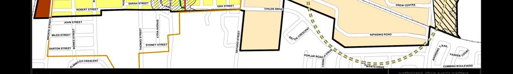
27 Commercial Milton Memorial Arena Existing Sidewalk DREW CENTRE Lions Sports Park Existing Pedestrian / Cyclist Linkage Potential GO Platform Extension ± 35m CA NA DIA NP THOMPSON RD. S. Proposed Pedestrian / Cyclist Linkage AC IFIC RA ILW AY S:\Korsiak & Company\HODERO\Milton\130 Thompson - Hodero\Pre-con\Aerial Photo\Oct 17\Hodero Aerial Photo w site plan zoom Oct dwg, LC Figure 6 Proposed Linkages
28 evidence base and policy framework for the preparation of an area specific Secondary Plan and also support the business case for all-day, two-way GO rail service. The Major Transit Station Area/Mobility Hub study represents an acknowledgement by Council and Staff that Milton s Official Plan is outdated and not in conformance with Provincial intensification policies. Town of Milton Tall Building Guidelines On May 7, 2018, Town Council endorsed the Milton Mid Rise and Tall Building Guidelines prepared by Planning and Development Staff. The Town has proactively developed these design guidelines to aid the integration of these types of developments into communities. They are recognition of the Province s emphasis on urban intensification and increasing developer interest in pursuing mid-rise and tall buildings in Milton. By clarifying the Town s expectations for the design of tall buildings, it is intended that the guidelines will assist with the interpretation of Official Plan policies and provide a clear design direction for development proposals. Developers are encouraged to have regard to the guidelines and Development Review staff will use them to evaluate development proposals. An Urban Design Brief has been prepared in support of this development proposal and demonstrates conformity with the Tall Building Guidelines. Conclusion In addition to the rationale presented in the original Planning Justification Report (December 2016) submitted in support of this development application, the residential intensification proposal at 130 Thompson Road South contributes to achieving the minimum intensification and density targets for the Urban Growth Centre and Major Transit Station Area prescribed by the Growth Plan. Likewise, it contributes to achieving a minimum of 5,300 new residential units within Milton s built-up area by 2031, as mandated by the Region. The two proposed alternative pedestrian/cyclist linkages meet the intent of the Official Plan by enhancing the current pedestrian/cyclist linkages to provide better and more pedestrian friendly connections to commercial uses along Drew Centre and the Go Station. In conclusion, the proposal intensifies underutilized lands within the urban growth centre and major transit station area, 22

29 is highly transit and pedestrian friendly, will reduce automobile dependency and will help strengthen the business case for all-day, two-way GO rail service. Respectfully submitted, KORSIAK URBAN PLANNING Jacob Kaven, MES, RPP Encl. Copy: Glen Hansen, Hodero Holdings Ltd., Encl. 23
May 24, Town of Milton Planning & Development Department 150 Mary Street Milton, ON L9T 6Z5. Director, Development Review
 May 24, 2018 Town of Milton Planning & Development Department 150 Mary Street Milton, ON L9T 6Z5 Attention: Chris Lupis, MCIP, RPP Director, Development Review Re: Planning Justification Report Update
Draft ROPA 43 - HPBATS/GTA West Corridor Protection
 Draft ROPA 4 - HPBATS/GTA West Corridor Protection Overview Purpose The purpose of Regional Official Plan Amendment (ROPA) No. 4 is to: Implement a corridor protection area to protect for the planned corridor
Figure 1- Site Plan Concept
 Figure 1- Site Plan Concept Parking will be provided underground on three levels at rate of 1.0 space/ unit; this rate includes all visitors parking. MMM Group has prepared a parking assessment (April,
Ontario Limited. Planning Justification Report. Zoning By-Law Amendment. 177 Cross Avenue Town of Oakville. October, 2012.
 915643 Ontario Limited Zoning By-Law Amendment Planning Justification Report 177 Cross Avenue Town of Oakville October, 2012 Prepared For: Prepared By: PLANNING JUSTIFICATION REPORT Proposed Zoning By-Law
Sustainable Growth. Sustainable Growth
 2 Sustainable Growth Sustainable Growth SUSTAINABLE GROWTH 2.1 COMMUNITY VISION... 2-5 2.2 THE CITY SYSTEM... 2-7 2.2.1 AREAS... 2-7 2.2.2 CITY-WIDE SYSTEMS... 2-8 2.2.3 PROVINCIAL PLAN BOUNDARIES AND
Employment and Commercial Review Analysis of Policy Directions
 Employment and Commercial Review Analysis of Policy Directions Appendix A The following analysis is town staff s response to the policy directions provided by the consultants who prepared the Employment
Trafalgar Road Corridor Planning Study Open House
 Trafalgar Road Corridor Planning Study Open House June 24, 2013 6:30-8:30 p.m. Oakville & Trafalgar Rooms Overview The Livable Oakville Plan identifies the lands along Trafalgar Road, between the QEW and
The protection of the agricultural resources of the Province;
 PART II INTRODUCTION An Official Plan is a policy document, which is intended to serve as the basis for making land use decisions and managing change in any municipality in Ontario. According to the Planning
The Corporation of the Town of Milton
 Report To: From: Council Barbara Koopmans, Commissioner, Planning and Development Date: May 7, 2018 Report No: Subject: Making it Possible Positioning the Town s Strategy for Growth and Economic Development
THE CITY OF VAUGHAN BY-LAW BY-LAW NUMBER A By-law to adopt Amendment Number 1 to the Official Plan of the Vaughan Planning Area.
 THE CITY OF VAUGHAN BY-LAW BY-LAW NUMBER 015-2014 A By-law to adopt Amendment Number 1 to the Official Plan of the Vaughan Planning Area. NOW THEREFORE the Council of the Corporation of the City of Vaughan
K. SMART ASSOCIATES LIMITED
 Planning Justification Report Zoning By-Law Amendment 185 King Street North Waterloo, Ontario April 7th, 2017 Project Reference Number 16-245 K. SMART ASSOCIATES LIMITED CONSULTING ENGINEERS AND PLANNERS
PUBLIC OPEN HOUSE HURONTARIO-MAIN CORRIDOR SECONDARY PLAN
 PUBLIC OPEN HOUSE HURONTARIO-MAIN CORRIDOR SECONDARY PLAN Tuesday, February 28, 2012 6pm 9pm 1 st Floor Atrium, City Hall 2 Wellington Street West, Brampton 1 POLICY FRAMEWORK The 2006 Provincial Growth
178 Carruthers Properties Inc.
 178 Carruthers Properties Inc. Planning Rationale for 178 Carruthers Avenue Site Plan Control Application June 2014 Table of Contents 1.0 Introduction 2.0 Overview of Subject Property 3.0 Current Zoning
2.0 A FRAMEWORK FOR SUSTAINABLE GROWTH CONTENTS
 2-2 A Framework for Sustainable Growth 2.0 A FRAMEWORK FOR SUSTAINABLE GROWTH CONTENTS 2.1 MANAGING SUSTAINABLE GROWTH THE VISION TO 2031 2.2 GOALS AND OBJECTIVES 2.2.1 Protecting the Natural Environment
PLANNING JUSTIFICATION REPORT
 PLANNING JUSTIFICATION REPORT Application for Official Plan and Zoning By-law Amendments 374 Martha Street Burlington, Ontario Prepared For: ADI Developments September 2014 14.543 Planning Justification
CONTENTS 2.0 A FRAMEWORK FOR SUSTAINABLE GROWTH 2.1 MANAGING SUSTAINABLE GROWTH THE VISION TO GOALS AND OBJECTIVES 2.3 MARKHAM STRUCTURE
 2 A Framework for Sustainable Growth 2.0 A FRAMEWORK FOR SUSTAINABLE GROWTH CONTENTS 2.1 MANAGING SUSTAINABLE GROWTH THE VISION TO 2031 2.2 GOALS AND OBJECTIVES 2.2.1 Protecting the Natural Environment
2136 & 2148 Trafalgar Road Town of Oakville Region of Halton
 PLANNING JUSTIFICATION REPORT 2136 & 2148 Trafalgar Road Town of Oakville Region of Halton Zoning By-Law Amendment Application 2500674 Ontario Inc. November 2016 Table of Contents Page 1.0 Location/Summary
Mark-up of the effect of the proposed Bronte Village Growth Area OPA No.18 on the text of section 24, Bronte Village, of the Livable Oakville Plan
 Mark-up of the effect of the proposed Bronte Village Growth Area OPA No.18 on the text of section 24, Bronte Village, of the Livable Oakville Plan Notes: This document is provided for information purposes
1.3 TRANSIT VISION 2040 FROM VISION TO ACTION THEME 1: PUTTING TRANSIT AT THE CENTRE OF COMMUNITIES. Fully integrate transit with community planning
 TRANSIT VISION 2040 FROM VISION TO ACTION TRANSIT VISION 2040 defines a future in which public transit maximizes its contribution to quality of life with benefits that support a vibrant and equitable society,
THE CORPORATION OF THE TOWN OF OAKVILLE BY-LAW NUMBER
 THE CORPORATION OF THE TOWN OF OAKVILLE BY-LAW NUMBER 2017-120 A by-law to adopt an amendment to the Livable Oakville Plan, Official Plan Amendment Number 20 (Downtown Oakville Growth Area) WHEREAS the
PORT WHITBY COMMUNITY
 PORT WHITBY COMMUNITY SECONDARY PLAN UPDATE COMMUNITY IMPROVEMENT PLAN URBAN DESIGN GUIDELINES September 2015 DRAFT PROPOSED AMENDMENT NUMBER # to the Whitby Official Plan PURPOSE: The intent of this Amendment
WELCOME and introduction
 1 WELCOME and introduction Mobility Hub Locations within Burlington STUDY OVERVIEW STUDY OBJECTIVES The City of Burlington is developing four Area Specific Plans, one for each of Burlington s Mobility
HEMSON C o n s u l t i n g L t d.
 INVENTORY & ASSESSMENT OF INTENSIFICATION OPPORTUNITIES City of Brampton Discussion i Paper for Public Review C o n s u l t i n g L t d. November 2008 EXECUTIVE SUMMARY This report is one of the key background
NEW REGIONAL OFFICIAL PLAN HIGH LEVEL PROCESS & FRAMEWORK
 NEW REGIONAL OFFICIAL PLAN HIGH LEVEL PROCESS & FRAMEWORK Why A New Official Plan Originally the role of Regionally Planning and content of Regional Official Plan (1970s) primarily focused on protecting
Proposed High-Density Apartment Building
 Planning Justification Report 1287 Costigan Road, Milton Proposed High-Density Apartment Building by IBI Group July 6, 2016 Table of Contents 1 Introduction... 1 2 Site and Area Details... 1 2.1 Neighbourhood
YONGE STEELES CORRIDOR SECONDARY PLAN. Young + Wright / IBI Group Architects Dillon Consulting Ltd. GHK International (Canada) Ltd.
 Ltd.") PART A: PREAMBLE 1.0 PURPOSE The purpose of this Secondary Plan is to provide a development framework for intensification of the Yonge/ Steeles corridor including the north side of Steeles Avenue West
PART A: PREAMBLE 1.0 PURPOSE The purpose of this Secondary Plan is to provide a development framework for intensification of the Yonge/ Steeles corridor including the north side of Steeles Avenue West
2.0 A FRAMEWORK FOR SUSTAINABLE GROWTH CONTENTS
 2-2 A Framework for Sustainable Growth 2.0 A FRAMEWORK FOR SUSTAINABLE GROWTH CONTENTS 2.1 MANAGING SUSTAINABLE GROWTH THE VISION TO 2031 2.2 GOALS AND OBJECTIVES 2.2.1 Protecting the Natural Environment
SUBJECT: Proposed Downtown Mobility Hub Precinct Plan and Proposed Official Plan Policies
 Page 1 of Report PB-81-17 SUBJECT: Proposed Downtown Mobility Hub Precinct Plan and Proposed Official Plan Policies TO: FROM: Committee of the Whole Planning and Building Department Report Number: PB-81-17
ONTARIO MUNICIPAL BOARD
 PL 120483 ONTARIO MUNICIPAL BOARD Applicant/Appellant: 2124123 Ontario Limited Subject: OPA, Rezoning and Draft Plan of Subdivision Municipal Address: 3940 Highway 7 East Municipality: City of Markham
Urban Design Manual PLANNING AROUND RAPID TRANSIT STATIONS (PARTS) Introduction. Station Study Areas
 Introduction. Station Study Areas") 111111 PLANNING AROUND RAPID TRANSIT STATIONS (PARTS) Introduction The ION rapid transit system will link Waterloo, Kitchener and Cambridge through a central transit corridor (CTC). There are a number
111111 PLANNING AROUND RAPID TRANSIT STATIONS (PARTS) Introduction The ION rapid transit system will link Waterloo, Kitchener and Cambridge through a central transit corridor (CTC). There are a number
Official Plan Review: Draft Built Form Policies
 PG.30.1 REPORT FOR ACTION Official Plan Review: Draft Built Form Policies Date: May 15, 2018 To: Planning and Growth Management Committee From: Chief Planner and Executive Director, City Planning Division
This page has been intentionally left blank.
 This page has been intentionally left blank. Chapter 3 3-2 3. Employment 3.A Niagara Economic Gateway 3.A.1 General The Niagara Economic Gateway comprises: a) The Gateway Economic Zone which includes all
SUBJECT: GO Station Mobility Hubs Preferred Concepts: Aldershot GO, Burlington GO and Appleby GO. Planning and Development Committee - Public Meeting
 Page 1 of Report PB-76-17 SUBJECT: GO Station Mobility Hubs Preferred Concepts: Aldershot GO, Burlington GO and Appleby GO TO: FROM: Planning and Development Committee - Public Meeting Planning and Building
2. Shaping Waterloo Region s Urban Communities
 2. Much of the region s growth over the past several decades has occurred in suburban areas that separated where people live from where they work and shop. This pattern of growth has increased the need
13 THORNHILL YONGE STREET STUDY IMPLEMENTATION CITY OF VAUGHAN OPA 669 AND TOWN OF MARKHAM OPA 154
 13 THORNHILL YONGE STREET STUDY IMPLEMENTATION CITY OF VAUGHAN OPA 669 AND TOWN OF MARKHAM OPA 154 The Planning and Economic Development Committee recommends the adoption of the recommendations contained
THE CORPORATION OF THE TOWN OF OAKVILLE BY-LAW NUMBER
 THE CORPORATION OF THE TOWN OF OAKVILLE BY-LAW NUMBER 20012-08530 A by-law to adopt an amendment to the Official Plan of the Oakville Planning Area (Official Plan Amendment 198) Land North of Dundas Street.
TOWN OF HALTON HILLS OFFICIAL PLAN AMENDMENT 10 PROPOSED MODIFICATIONS. Premier Gateway Employment Lands Re-Phasing. to implement
 TOWN OF HALTON HILLS OFFICIAL PLAN AMENDMENT 0 PROPOSED MODIFICATIONS Premier Gateway Employment Lands Re-Phasing to implement Halton Peel Boundary Area Transportation Study/ GTA West Corridor Protection
URBAN DESIGN BRIEF. 2136&2148 Trafalgar Road. Town of Oakville
 URBAN DESIGN BRIEF 2136&2148 Trafalgar Road Town of Oakville Prepared By: METROPOLITAN CONSULTING INC For 2500674 Ontario Inc November 2016 TABLE OF CONTENTS Page No. 1.0 Introduction/Description of Subject
PLANNING AND URBAN DESIGN RATIONALE REPORT. Hunters Pointe Golf Course Redevelopment 289 Daimler Parkway Prepared For: Ontario Ltd.
 PLANNING AND URBAN DESIGN RATIONALE REPORT Hunters Pointe Golf Course Redevelopment 289 Daimler Parkway Prepared For: 2599587 Ontario Ltd. February 2018 Redevelopment of Hunters Pointe Golf Course, Welland
Midtown Oakville will be a vibrant, transit-supportive, mixed use urban community and employment area.
 Livable Oakville Part E: Growth Areas, Special Policy Areas and Exceptions 20. MIDTOWN OAKVILLE 20.1 Goal The interchange of Trafalgar Road and the QEW and the Oakville GO Station are major entry points
1.0 PLANNING MARKHAM S FUTURE CONTENTS
 1-1 Planning Markham s Future 1.0 PLANNING MARKHAM S FUTURE CONTENTS 1.1 THE PURPOSE OF THE OFFICIAL PLAN 1.2 THE MARKHAM CONTEXT 1.3 THE REGULATORY CONTEXT 1.3.1 Province of Ontario 1.3.2 York Region
CONTENTS 8.0 LAND USE 8.1 GENERAL LAND USE 8.2 RESIDENTIAL 8.3 MIXED USE 8.4 COMMERCIAL 8.5 EMPLOYMENT LANDS
 8-2 Land Use 8.0 LAND USE CONTENTS 8.1 GENERAL LAND USE 8.1.1 Uses provided for in all Land Use Designations 8.1.2 Uses prohibited in Hazardous Lands, Hazardous Sites and Special Policy Areas 8.1.3 Uses
WITNESS STATEMENT Of. Ronald Blake. On behalf of the Intervenor The Corporation of the City of Markham
 Filed: 2013-06028 EB-2012-0451 Exhibit L.EGD.COM.2 Page 1 of 7 WITNESS STATEMENT Of Ronald Blake On behalf of the Intervenor The Corporation of the City of Markham In the matter of an application by Enbridge
SCHEDULE 'A' TO BY-LAW as Amended by AMENDMENT NO. 90 TO THE WHITBY OFFICIAL PLAN
 SCHEDULE 'A' TO BY-LAW 6413-10 as Amended by 6553-11 AMENDMENT NO. 90 TO THE WHITBY OFFICIAL PLAN SECTION A: GROWTH PLAN CONFORMITY PURPOSE: LOCATION: BASIS: The purpose of this Amendment is to: conform
141 GEORGE STREET PLANNING RATIONALE
 141 GEORGE STREET PLANNING RATIONALE MINOR ZONING BY-LAW AMENDMENT NOVEMBER 2, 2016 PLANNING RATIONALE 223 McLeod Street Ottawa, ON K2P 0Z8 613.730.5709 fotenn.com INTRODUCTION FOTENN Consultants is acting
TOWN OF HALTON HILLS OFFICIAL PLAN AMENDMENT 10 PROPOSED MODIFICATIONS. Premier Gateway Employment Lands Re-Phasing. to implement
 TOWN OF HALTON HILLS OFFICIAL PLAN AMENDMENT 0 PROPOSED MODIFICATIONS Premier Gateway Employment Lands Re-Phasing to implement Halton Peel Boundary Area Transportation Study/ GTA West Corridor Protection
5 TOWN OF MARKHAM OFFICIAL PLAN AMENDMENT NO. 144 MILLIKEN MAIN STREET SECONDARY PLAN
 5 TOWN OF MARKHAM OFFICIAL PLAN AMENDMENT NO. 144 MILLIKEN MAIN STREET SECONDARY PLAN The Planning and Economic Development Committee recommends the following: 1. The communication from Brendan O Callaghan,
New Official Plan. Policy Paper. Urban Design
 New Official Plan Policy Paper Urban Design Planning Services Department February 2009 Policy Paper: Urban Design URBAN DESIGN DISCUSSION PAPER 1.0 EXECUTIVE SUMMARY 2.0 OAKVILLE OFFICIAL PLAN REVIEW 2.1
Draft Urban Hamilton Official Plan. Amendment No. XX
 1 of 75 The following text, together with: Draft Appendix A Appendix B Volume 1, Schedule E-1 Urban Land Use Designations Appendix C Volume 1, Appendix A Parks Classification Map Appendix D Volume 1, Appendix
GO Station Mobility Hubs: Draft Precinct Plans. Committee of the Whole July 12, 2018
 GO Station Mobility Hubs: Draft Precinct Plans Committee of the Whole July 12, 2018 Purpose of this Workshop Present Draft Precinct Plans for the 3 GO Station Mobility Hubs Continue the conversations that
1 Introduction. Chapter. In this chapter:
 Chapter 1 Introduction In this chapter: 1.1 A Snapshot of the Region 1.2 Towards a Sustainable Region 1.3 The Provincial Context 1.4 Purpose and Organization The Regional Municipality of York Official
Official Plan Review
 Official Plan Review Summary Report - The Built Environment August 2014 Part 1: Introduction Planning for a healthy, prosperous and sustainable community is an important goal for our municipality. From
The Corporation of the TOWN OF MILTON
 Report to: From: Chair & Members of the Administration & Planning Standing Committee W.F. Mann, Director of Planning and Development Date: April 16, 2012 PD 022-12 (Z19/11) Subject: Technical Report Proposed
SCARBOROUGH SUBWAY EXTENSION. Scarborough Subway Extension. Final Terms of Reference
 Scarborough Subway Extension Final Terms of Reference 1 1.0 Introduction and Background 1.1 Introduction Toronto City Council recently confirmed support for an extension of the Bloor-Danforth Subway from
The West Vaughan Employment Area Secondary Plan Policies
 Part 2: The West Vaughan Employment Area Secondary Plan Policies 2.1 General Policies It is the policy of Council: 2.1.1. That the West Vaughan Employment Area (the WVEA), identified on Schedule 1, will
Growth Area Reviews Preliminary Directions for Midtown Oakville, the Uptown Core and Palermo Village
 Growth Area Reviews Preliminary Directions for Midtown Oakville, the Uptown Core and Palermo Village Livable Oakville Council Subcommittee January 15, 2018 1 Introduction Why a study? January 2014 Signaled
and services The protection and conservation of environmentally significant and sensitive natural heritage features and functions.
 6. Land Use 6.0 Preamble A healthy and livable city is one in which people can enjoy a vibrant economy and a sustainable healthy environment in safe, caring and diverse neighbourhoods. In order to ensure
2 STATUTORY PUBLIC MEETING AND INFORMATION REPORT FOR PUBLIC MEETING ON AMENDMENT NO. 62 TO THE YORK REGION OFFICIAL PLAN
 2 STATUTORY PUBLIC MEETING AND INFORMATION REPORT FOR PUBLIC MEETING ON AMENDMENT NO. 62 TO THE YORK REGION OFFICIAL PLAN Pursuant to Section 17(15) of the Planning Act, as amended, the Regional Planning
*** DRAFT 2 FOR PUBLIC REVIEW ***
 6.7 The area is generally bounded by the Red Hill Valley Parkway to the west, Lake Avenue to the east, the Queen Elizabeth Way (QEW) to the north, and by the properties just south of Queenston Road to
and Richmond Street West - Official Plan Amendment Application - Preliminary Report
 STAFF REPORT ACTION REQUIRED 822-838 and 860-862 Richmond Street West - Official Plan Amendment Application - Preliminary Report Date: August 14, 2017 To: From: Wards: Reference Number: Toronto and East
4800 Yonge Street - Official Plan Amendment, Zoning Amendment and Site Plan Applications - Request for Direction Report
 STAFF REPORT ACTION REQUIRED 4800 Yonge Street - Official Plan Amendment, Zoning Amendment and Site Plan Applications - Request for Direction Report Date: April 16, 2018 To: From: Wards: Reference Number:
12 AMENDMENT NO. 149, TOWN OF MARKHAM HIGHWAY 404 NORTH SECONDARY PLAN
 12 AMENDMENT NO. 149, TOWN OF MARKHAM HIGHWAY 404 NORTH SECONDARY PLAN The Planning and Economic Development Committee recommends the adoption of the recommendation contained in the following report August
MAYFIELD WEST SECONDARY PLAN PHASE 2
 MAYFIELD WEST SECONDARY PLAN PHASE 2 Council Information Workshop February 16, 2010 Draft Preferred Land Use Plan TOWN OF CALEDON PLANNING & DEVELOPMENT DEPARTMENT Workshop Agenda TOWN OF CALEDON 1. Welcome
3 TOWN OF WHITCHURCH-STOUFFVILLE OFFICIAL PLAN AMENDMENT NOS. 116 & 117
 3 TOWN OF WHITCHURCH-STOUFFVILLE OFFICIAL PLAN AMENDMENT NOS. 116 & 117 The Planning and Economic Development Committee recommends the adoption of the recommendations contained in the following report,
1.0 Purpose of a Secondary Plan for the Masonville Transit Village
 Report to Planning and Environment Committee To: Chair and Members Planning & Environment Committee From: John M. Fleming Managing Director, Planning and City Planner Subject: Masonville Transit Village
Growing Community Urban Settlement Area and Hidden Valley Settlement Area
 Town of Huntsville Official Plan Review - POLICY BACKGROUND PAPER Growing Community Urban Settlement Area and Hidden Valley Settlement Area BACKGROUND: Through the Provincial Policy Statement (PPS), the
Welcome. Walk Around. Talk to Us. Write Down Your Comments
 Welcome This is an information meeting introducing the applications for proposed redevelopment of the Yorkdale Shopping Centre site at 3401 Dufferin Street and 1 Yorkdale Road over the next 20+ years,
6 Growth Management Challenges and Opportunities
 6 Growth Management Challenges and Opportunities The Town has established a goal of attaining a 50% participation rate with respect to employment opportunities versus residential population. The Town s
SECTION ONE: INTRODUCTION. introduction
 introduction 1 INTRODUCTION Since it was first established in 1843 as a trading post for the Hudson s Bay Company, Victoria has evolved into a Provincial capital city that is recognized across Canada and
Complete Neighbourhood Guidelines Review Tool
 Complete Neighbourhood Guidelines Review Tool Prepared By: City of Regina Planning Department October 2014 Page 1 of 14 Community Development Review Checklist for Secondary Plans and Concept Plans The
QUEEN-RIVER SECONDARY PLAN
 34 QUEEN-RIVER SECONDARY PLAN 34. QUEEN RIVER SECONDARY PLAN 1. INTRODUCTION The Queen-River area is approximately 6.4 hectares and is located at the eastern edge of the Downtown as shown on Map 34-1.
SUBJECT: Waterfront Hotel Planning Study Update TO: Planning and Development Committee FROM: Department of City Building. Recommendation: Purpose:
 Page 1 of Report PB-23-18 SUBJECT: Waterfront Hotel Planning Study Update TO: Planning and Development Committee FROM: Department of City Building Report Number: PB-23-18 Wards Affected: 2 File Numbers:
Summary of Changes for the Comprehensive Draft Proposed Official Plan Amendment
 Summary of Changes for the Comprehensive Draft Proposed Official Plan Amendment Note: Due to the broad scope of the Official Plan Review, this list is not exhaustive of the extent of changes in the comprehensive
Port Credit Local Advisory Panel October 20 th Meeting
 Port Credit Local Advisory Panel October 20 th Meeting Focus Of This Evening s Meeting: 1. Hurontario Main Street Higher Order Transit Study 2. Port Credit Mobility Hub & GO Station Parking Structure Study
The lands identified as Residential Areas on Schedule A1, Urban Structure, represent the areas that provide for stable residential communities.
 Livable Oakville Part D: Land Use Designations and Policies 11. RESIDENTIAL 11.1 General The lands identified as Residential Areas on Schedule A1, Urban Structure, represent the areas that provide for
5 Direct Growth. 5.1 Introduction
 5 Direct Growth 5.1 Introduction Mississauga s population and employment growth prospects are expected to remain strong over the next 25 years. Mississauga has sufficient land to accommodate projected
1120 Haist Street - Pelham Arena Community Co-Design Recommendation Report Haist Street - Pelham Arena Community Co-Design Recommendation Report
 1120 Haist Street - Pelham Arena Community Co-Design Executive Summary: In May, 2017 the Town retained the services of The Planning Partnership to undertake a community design charrette process to determine
Planning Justification Brief
 Planning Justification Brief Proposed Re-Zoning Halton Catholic District School Board 302, 312, 324, 332 Rebecca Street Lots 4, 5, 6, & 7 and Blocks A & B Registered Plan 552 May 2017 Introduction Strategy
THE GARDEN CITY PLAN. City of St. Catharines Official Plan. City of St. Catharines
 THE GARDEN CITY PLAN City of St. Catharines Official Plan City of St. Catharines August 2010 APPROVAL INFORMATION This Official Plan of the City of St. Catharines Planning Area, known as the Garden City
Planning Justification Report. Milton Meadows Properties Ltd. Milton Meadows South IN SUPPORT OF ZONING BY-LAW AMENDMENT & DRAFT PLAN OF SUBDIVISION
 Planning Justification Report Milton Meadows Properties Ltd. Milton Meadows South IN SUPPORT OF ZONING BY-LAW AMENDMENT & DRAFT PLAN OF SUBDIVISION For Part of Lot 3, Concession 1 Town of Milton HUMPHRIES
Prepared for: Jacal Holdings Ltd. Prepared by: Korsiak Urban Planning & KNYMH Inc. Revised: May 2018
 Prepared for: Jacal Holdings Ltd. Prepared by: Korsiak Urban Planning & KNYMH Inc. Revised: May 2018 PART A: DESIGN VISION, GUIDING PRINCIPLES AND OBJECTIVES 1. Preface 3 2. Introduction 3 3. Design Vision
SUBJECT: Revised proposed new official plan recommended for adoption
 Page 1 of Report PB-04-18 SUBJECT: Revised proposed new official plan recommended for adoption TO: FROM: Planning and Development Committee Department of City Building Report Number: PB-04-18 Wards Affected:
Proposed UHAUL Burlington Interior Self Storage & Vehicle Rental Facility
 Proposed UHAUL Burlington Interior Self Storage & Vehicle Rental Facility AMERCO Real Estate / UHAUL Co. 3267 Mainway Rd. Burlington, Ontario April, 2018 Prepared By: Strategy4 Inc. 1. Introduction: The
AMENDMENT NUMBER ## TO THE VAUGHAN OFFICIAL PLAN 2010 FOR THE VAUGHAN PLANNING AREA
 AMENDMENT NUMBER ## TO THE VAUGHAN OFFICIAL PLAN 2010 FOR THE VAUGHAN PLANNING AREA The following text and schedules "1", 2, 3, 4 and 5 constitute Amendment Number ## to the Official Plan of the Vaughan
Municipal Development Plan Update Urban Service Area and Hamlets
 ENCLOSURE 1 Municipal Development Plan Update Urban Service Area and Hamlets Priorities Committee January 24, 2017 MUNICIPAL DEVELOPMENT PLAN UPDATE SHAPING OUR FUTURE MDP Update - Agenda MDP Update Public
[PLANNING RATIONALE] For Site Plan Control and Lifting of Holding Zone By-Law 101 Champagne Avenue. May 23, 2014
![[PLANNING RATIONALE] For Site Plan Control and Lifting of Holding Zone By-Law 101 Champagne Avenue. May 23, 2014](/thumbs/75/71599615.jpg "[PLANNING RATIONALE] For Site Plan Control and Lifting of Holding Zone By-Law 101 Champagne Avenue. May 23, 2014") [PLANNING RATIONALE] For Site Plan Control and Lifting of Holding Zone By-Law 101 Champagne Avenue May 23, 2014 Contents 1.0 Introduction... 2 2.0 Site Context... 2 2.1 Adjacent Uses... 2 Figure 1: Site
[PLANNING RATIONALE] For Site Plan Control and Lifting of Holding Zone By-Law 101 Champagne Avenue May 23, 2014 Contents 1.0 Introduction... 2 2.0 Site Context... 2 2.1 Adjacent Uses... 2 Figure 1: Site
City of Welland Commercial Policies. Public Information Centre March 25 th, 2009
 City of Welland Commercial Policies Public Information Centre March 25 th, 2009 Presentation Outline Presentation will address the following four areas: Purpose of this Public Information Centre? Why does
Commercial, Retail and Tourism Executive Summary December 2018
 Town of Wasaga Beach Official Plan Review, Retail and Executive Summary December 2018 1 An Official Plan directs where and how to grow The preparation of a new Official Plan for Wasaga Beach is an opportunity
CONSULTING SERVICES FOR THE WHITEBELT VISIONING EXERCISE ADDENDUM TO THE GTA WEST LAND USE STUDY WORK PROGRAM
 CONSULTING SERVICES FOR THE WHITEBELT VISIONING EXERCISE ADDENDUM TO THE GTA WEST LAND USE STUDY 1. Introduction WORK PROGRAM The Town of Caledon is a large, local municipality located in the Greater Toronto
8 Oak Street - Official Plan and Zoning By-law Amendment Application - Preliminary Report
 STAFF REPORT ACTION REQUIRED 8 Oak Street - Official Plan and Zoning By-law Amendment Application - Preliminary Report Date: March 17, 2014 To: From: Wards: Reference Number: Planning and Growth Management
9 CITY OF VAUGHAN OFFICIAL PLAN AMENDMENT NO BOCA EAST INVESTMENTS LIMITED
 9 CITY OF VAUGHAN OFFICIAL PLAN AMENDMENT NO. 631 - BOCA EAST INVESTMENTS LIMITED The Planning and Economic Development Committee recommends the adoption of the recommendations contained in the following
New Official Plan Quest November 2013
 City of Markham New Official Plan Quest November 2013 Building Markham s Future Together - 6 Key Strategic Priorities 1. Growth - Managing our Growth 2. Transportation/Transit - Improving transportation
URBAN DESIGN BRIEF New Street Burlington, ON
 3225-3237 New Street Burlington, ON MARCH 2017 Prepared for: Royal Living Development Group Inc. Prepared by: adesso design inc. 218 Locke Street South, 2nd Floor Hamilton, ON L8P 4B4 t. 905.526.8876 3225-3237
Town of Oakville Name of public meeting/open house etc. Info. Session. Palermo Village Growth Area Review
 Town of Oakville Name of public meeting/open house etc. Info. Session Palermo Village Growth Area Review Town of Oakville Name Official of Plan public Review meeting/open house etc. What is an Official
THE CITY OF VAUGHAN BY-LAW BY-LAW NUMBER
 THE CITY OF VAUGHAN BY-LAW BY-LAW NUMBER 177-2018 A By-law to adopt Amendment Number 33 to the Vaughan Official Plan 2010 for the Vaughan Planning Area. NOW THEREFORE the Council of the Corporation of
A Growing Community Rural Settlement Areas
 Town of Huntsville Official Plan Review - POLICY BACKGROUND PAPER A Growing Community Rural Settlement Areas BACKGROUND: In addition to the fully municipally-serviced Urban Settlement Area and the Hidden
Speers Road Corridor Study. Livable Oakville (Official Plan) Council Sub Committee March 20, 2017
 Council Sub Committee March 20, 2017") Speers Road Corridor Study Livable Oakville (Official Plan) Council Sub Committee March 20, 2017 Overview 1) Study Purpose & Background 2) Study Area 3) Policy Context and Plan Review 4) Speers Road Corridor
Speers Road Corridor Study Livable Oakville (Official Plan) Council Sub Committee March 20, 2017 Overview 1) Study Purpose & Background 2) Study Area 3) Policy Context and Plan Review 4) Speers Road Corridor
Portage Parkway Environmental Assessment Public Information Centre No. 1
 City of Vaughan Portage Parkway Environmental Assessment Public Information Centre No. 1 November 25, 2015 Welcome to the Public Information Centre This first Public Information Centre (PIC) introduces
150 Eighth Street Zoning By-law Amendment Application Preliminary Report
 REPORT FOR ACTION 150 Eighth Street Zoning By-law Amendment Application Preliminary Report Date: March 27, 2019 To: Etobicoke York Community Council From: Director, Community Planning, Etobicoke York District
770 Don Mills Road and 805 Don Mills Road - Official Plan Amendment and Zoning By-law Amendment Application Preliminary Report
 REPORT FOR ACTION 770 Don Mills Road and 805 Don Mills Road - Official Plan Amendment and Zoning By-law Amendment Application Preliminary Report Date: To: From: Wards: June 22, 2018 North York Community