General Location Annex, Rezone & Preliminary Plat Lansdowne Addition, Unit Three
|
|
|
- Vivien Armstrong
- 5 years ago
- Views:
Transcription
1 NEWFOUNDLAND I-5 Agricultural District Subject Site SUNDANCE ANDERSON Single Family Residential CHRISTY PUD Agricultural District Highway Business General Location Annex, Rezone & Preliminary Plat Lansdowne Addition, Unit Three Feet

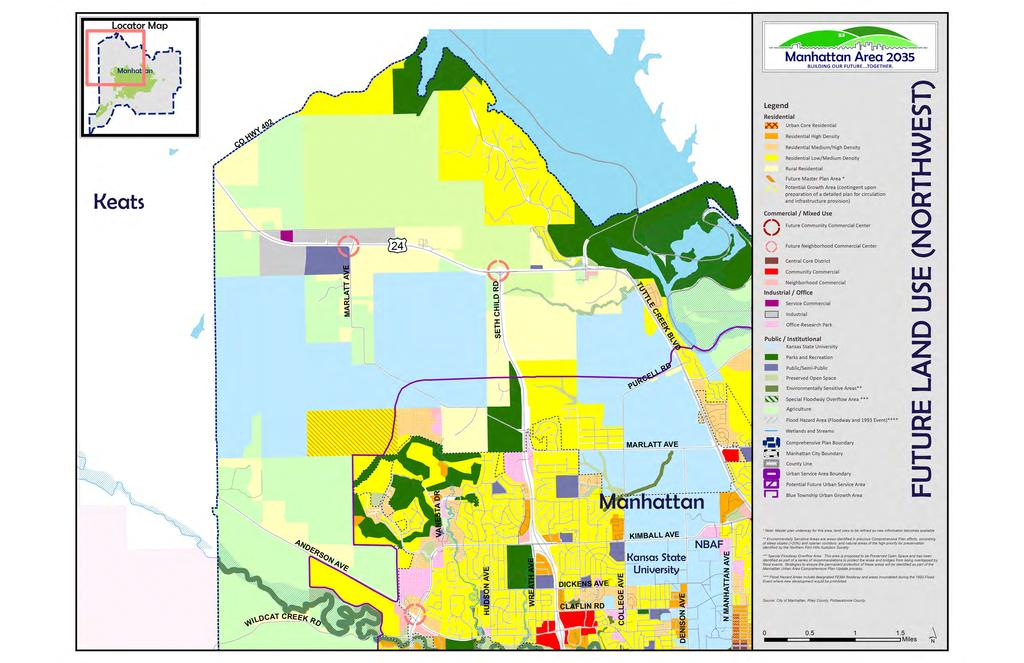
2 INTER-OFFICE MEMORANDUM DATE: September 24, 2015 MEETING: October 5, 2015 TO: FROM: RE: Manhattan Urban Area Planning Board Chase Johnson, CFM, Planner Annexation of Lansdowne Addition, Unit Three BACKGROUND BK Investments, LLC Tom Abbott has requested annexation of two tracts of land to be known as the Lansdowne Addition, Unit Three. The two tracts measure approximately 3.2 acres in area. The proposed Preliminary Plat of Lansdowne Addition, Unit Three consists of six (6) large, single-family detached lots (currently vacant) and one (1) large two-family lot that is improved with an existing two-family residential structure. The two tracts are generally located to the northwest of the intersection of Anderson Avenue and Christy Drive. Christy Drive is located within the City and is an existing improved urban section city street. A combination of medium density residential townhomes and two-family residential neighborhoods are located to the east of Christy Drive. Low density singlefamily rural residential is located to the west of the proposed annexation area. Lansdowne Addition, Unit Three is proposed to be rezoned from County AG, Agriculture District and County SF-1, Single-Family District, to R-1, Single-Family Residential District and R-2, Two-family Residential District. A Preliminary Plat has been submitted for the two tracts. When considering an annexation request, the Manhattan Urban Area Planning Board shall make a recommendation on the proposed annexation based on the Comprehensive Plan for the Manhattan Urban Area, the Growth Vision, and the Capital Improvements Program (CIP). FUTURE LAND USE MAP OF THE COMPREHENSIVE PLAN The proposed annexation area is shown on the Future Land Use Map in the northwest planning area and the West Anderson Corridor (WAC) Special Planning Area. The
3 Page 2 annexation area is designated as Agriculture (AG). In addition, the Future Land Use Map identifies the area surrounding the intersection of Anderson Avenue and Scenic Drive as a future Neighborhood Commercial Center node. It is reasonable to assume that density will be greater near the intersection and transition to less dense environments farther away from the commercial node. Since the existing development patterns to the east of the proposed annexation area are Residential Medium to High (RMH) Density, the Residential Low to Medium (RLM) Density policies have been included below as a reference to the transitioning development patterns from the intersection of Scenic Drive and Anderson Avenue. AG Policies Include: AG: Uses Primary: Farming, ranching, and other agriculturally related uses. Secondary: Very low density rural residential. AG: Characteristics Areas are not anticipated to be developed within the 20-year planning horizon of this plan. Continuation of agricultural uses is encouraged within the context of both market demand and the desires of individual property owners. Residences are typically limited to those for owners/operators of the agricultural enterprise. RLM Policies Include: RLM-1: Characteristics The Residential Low to Medium Density designation incorporates a range of singlefamily, single-family attached, duplex, and town homes, and in appropriate cases include complementary neighborhood-scale supporting land uses, such as retail, service commercial, and office uses in a planned neighborhood setting, provided they conform with policies for Neighborhood Commercial Centers. Small-scale multiple-family buildings and condominiums may be permissible as part of a planned unit development, or special mixed-use district, provided open space requirements are adequate to stay within desired densities. RLM-2: Appropriate Density Range Densities in the Residential Low to Medium Density designation range between less than one dwelling unit/acre up to 11 dwelling units per net acre. RLM-3: Location Residential Low to Medium Density neighborhoods typically should be located where they have convenient access to and are within walking distance to community facilities and services that will be needed by residents of the neighborhood, including parks, schools, shopping areas, transit and other community facilities. Where topographically feasible, neighborhoods should be bounded by major streets (arterials and/or collectors)
4 Page 3 with a direct connection to work, shopping, and recreational activities. The Residential Low to Medium Density designation includes most established neighborhoods outside of the core area as well as future residential growth areas to the west and east. RLM-4: Variety of Housing Styles To avoid monotonous streetscapes, the incorporation of a variety of architectural styles is strongly encouraged in all new development, West Anderson Corridor Special Planning Area Policies (WAC) Background and Intent The West Anderson Corridor is contiguous to the western boundary of Manhattan and is considered as an area for potential future growth. The scenic quality of the corridor is significant, defined by the Wildcat Creek Riparian area, which bounds its southern edge and by the lush agricultural lands that extend south from Anderson Avenue to the creek. The corridor will remain primarily rural in nature within the near-term or until such time as utility services are available. To the extent possible, both the scenic quality and availability of developable land within the corridor should be preserved. As the market for growth in the corridor emerges, compatibility with Fort Riley and specific recommendations made by the 2005 Flint Hills Joint Land Use Study are a key consideration. WAC-1: Preservation of Wildcat Creek Riparian Corridor Design land use patterns in the Wildcat Creek Corridor to protect natural features, including steep slopes, native vegetation, riparian corridors, streams, and wetlands, in accordance with the adopted Wildcat Creek Floodplain Management Plan. WAC-2: Future Growth Area The West Anderson Corridor is identified as a potential future growth area, dependent upon the timing, and availability of infrastructure and urban services. Evaluate development proposals within the West Anderson Corridor based upon their compatibility with the area s potential for future urban development and the recommendations of the 2005 Flint Hills Joint Land Use Study. Discourage isolated parcels of development that will lead to fragmented patterns of urban development. WAC-3: Future Neighborhood Services and Residential Development The West Anderson Corridor provides potential for additional Neighborhood Commercial services and specialty stores in the vicinity of the Anderson Avenue Scenic Drive intersection. Explore the provision of low to medium density housing along the south side of Anderson Avenue, transitioning to the riparian open space corridor, along Wildcat Creek. WAC-4: Multi-modal Connectivity As development opportunities emerge, explore and implement opportunities to enhance multi-modal connections between the West Anderson Corridor and existing multi-modal facilities in other parts of the Planning Area.
5 Page 4 Considering the existing development patterns of adjacent properties and the planning area polices outlined above, the proposed annexation conforms to the Manhattan Urban Area Comprehensive Plan. GROWTH VISION The proposed annexation conforms to the policy directions provided by the Growth Vision in the Comprehensive Plan. The Growth Vision recommends the incorporation into the City of those areas that are physically, socially, and economically a part of the City, and encourages orderly, contiguous growth and expansion into areas that can be served with City services. CAPITAL IMPROVEMENTS PROGRAM and SERVICEABILITY The tract is shown on the Manhattan Urban Area Comprehensive Plan Map to be at the edge of the Urban Service Area (map attached). As such, the site can be easily served by public improvements, including existing Christy Drive, water, fire service and sanitary sewer. It should be noted that the existing two-family residential structure located on proposed Lot 1, Lansdowne Addition, Unit Three is currently served by a private sanitary sewer lateral field system. Note: As a condition of annexation, whenever the lateral field for this property fails in the future, if the property is renovated, redeveloped, or connected to City water service, or if any City, County, State or Federal agency or agent with sufficient legal authority determines it to be necessary, the property shall be required to connect to the City s sanitary sewer system at the cost of the property owner. ALTERNATIVES It appears the MUAPB has the following alternatives concerning the issue at hand. The Board may: 1. Recommend approval of the annexation of Lansdowne Addition, Unit Three, based on conformance with the Future Land Use Map of the Comprehensive Plan for the Manhattan Urban Area and the City of Manhattan, Kansas, the Growth Vision, and the Capital Improvements Program (CIP), subject to the one (1) condition of approval recommended by City Administration. 2. Recommend denial of the annexation Lansdowne Addition, Unit Three, for specifically stated reasons. 3. Table the annexation of Lansdowne Addition, Unit Three, to a specific date, indicating the reasons for tabling.
6 Page 5 RECOMMENDATION While the annexation site is not shown as residential in the Comprehensive Plan, it is directly adjacent to Christy Drive, an existing city street that is in the process of developing along its east side with the Four Winds Townhomes PUD. As such it is reasonable to expect the west side of Christy Drive to develop with low density urban residential uses. City Administration recommends approval of the annexation of Lansdowne Addition, Unit Three, an approximate 3.2 acre tract of land generally located to the northwest of the intersection of Anderson Avenue and Christy Drive, based on conformance with the Future Land Use Map of the Comprehensive Plan for the Manhattan Urban Area and the City of Manhattan, Kansas, the Growth Vision, and the Capital Improvements Program (CIP), subject to the following condition of approval: 1. Whenever the lateral field on proposed Lot 1, Lansdowne Addition, Unit Three fails in the future, if the property on Lot 1 is renovated, redeveloped, or connected to City water service, or if any City, County, State or Federal agency or agent with sufficient legal authority determines it to be necessary, the property shall be required to connect to the City s sanitary sewer system at the cost of the property owner. POSSIBLE MOTION The Manhattan Urban Area Planning Board recommends approval of the annexation of Lansdowne Addition, Unit Three, an approximate 3.2 acre tract of land generally located northwest of the intersection of Anderson Avenue and Christy Drive, based on conformance with the Future Land Use Map of the Comprehensive Plan for the Manhattan Urban Area and the City of Manhattan, Kansas, the Growth Vision, and the Capital Improvements Program, subject to the one (1) condition of approval recommended by City Administration. CJ 15154}MUAPB}AnnexLansdowneUnit3
7
Chapter 4: Land Use and Growth Management
 LAND USE AND GROWTH MANAGEMENT 4-1 Chapter 4: Land Use and Growth Management BACKGROUND AND INTENT Growth brings a number of benefits to a community; however, it also brings a number of impacts and costs.
Proposed Kenmount Hill CDS Amendment. Public Hearing October 25 th, 2018
 Proposed Kenmount Hill CDS Amendment Public Hearing October 25 th, 2018 History of Kenmount Hill Why Kenmount Hill? Why Now? We are a city with a vision for growth and the development of Kenmount Hill
CHAPTER 7: VISION AND ACTION STATEMENTS. Noble 2025 Vision Statement
 CHAPTER 7: VISION AND ACTION STATEMENTS This chapter presents the vision, policy and action statements that transform the comprehensive planning study, an analysis of Noble s past, future trends and community
General Location Courtyard at LMH Final Development Plan and Final Plat
 R-1 LEYDEN RIDGE LOMA RIDGE LOBDELL R-3 MILLER PARKWAY LAUSSAC Subject Property R-3 LOCHENSHIRE LESMER R General Location Courtyard at LMH Final Development Plan and Final Plat ¹ 230 115 0 230 Feet Airport
Chapter 5: Natural Resources and Environment
 NATURAL RESOURCES AND ENVIRONMENT 5-1 5 Chapter 5: Natural Resources and Environment BACKGROUND AND INTENT Urban expansion represents the greatest risk for the future degradation of existing natural areas,
Gold Line Bus Rapid Transit Transit Oriented Development (BRTOD) Helmo Station Area Plan
 Helmo Station Area Plan") Appendix F Gold Line Bus Rapid Transit Transit Oriented Development (BRTOD) Helmo Station Area Plan Introduction and Purpose of the Plan The Gold Line Bus Rapid Transit facility is an eleven-mile dedicated
Appendix F Gold Line Bus Rapid Transit Transit Oriented Development (BRTOD) Helmo Station Area Plan Introduction and Purpose of the Plan The Gold Line Bus Rapid Transit facility is an eleven-mile dedicated
ADMINISTRATION RECOMMENDATION 2016 November 03. That Calgary Planning Commission recommends APPROVAL of the proposed Land Use Amendment.
 Page 1 of 12 EXECUTIVE SUMMARY This Land Use Amendment application covers an area of 75.76 hectares ± (187.20 acres ±) located in northeast Calgary, bound by Stoney Trail NE to the north, 128 Avenue NE
Sewanee Village + Request for Builder/Developer Proposals
 Sewanee Village + Request for Builder/Developer Proposals Contact: Frank X. Gladu Special Assistant to the Vice Chancellor University of the South 735 University Ave Version 3 Sewanee TN 37383 Released:
Ten Mile Creek Planning Area
 PLANNING AREA POLICIES TEN MILE CREEK Ten Mile Creek Planning Area Location and Context The Ten Mile Creek Planning Area ( Ten Mile Creek area ) is located south of the current Boise AOCI, generally south
LAND USE AMENDMENT CORNERSTONE (WARD 3) COUNTRY HILLS BOULEVARD AND STONEY TRAIL NE BYLAW 9D2017
 COUNTRY HILLS BOULEVARD AND STONEY TRAIL NE BYLAW 9D2017") Page 1 of 12 EXECUTIVE SUMMARY This Land Use Amendment application covers an area of 54.92 hectares ± (135.71 acres ±) located in northeast Calgary, bound by Country Hills Boulevard NE to the north and
Page 1 of 12 EXECUTIVE SUMMARY This Land Use Amendment application covers an area of 54.92 hectares ± (135.71 acres ±) located in northeast Calgary, bound by Country Hills Boulevard NE to the north and
Rapid City Planning Commission Comprehensive Plan Amendment Project Report
 Rapid City Planning Commission Comprehensive Plan Amendment Project Report June 7, 2018 Applicant Request(s) Item #3 Case # 18CA001 Comprehensive Plan Amendment to change the future land use from Mixed-
LAND USE AMENDMENT CORNERSTONE (WARD 3) 60 STREET NE AND COUNTRY HILLS BOULEVARD NE MAP 26NE BYLAW 22D2017
 60 STREET NE AND COUNTRY HILLS BOULEVARD NE MAP 26NE BYLAW 22D2017") Page 1 of 14 EXECUTIVE SUMMARY This Land Use Amendment application covers an area of 43.76 hectares ± (108.14 acres ±) located in northeast Calgary, bound by Country Hills Boulevard NE to the south and
Page 1 of 14 EXECUTIVE SUMMARY This Land Use Amendment application covers an area of 43.76 hectares ± (108.14 acres ±) located in northeast Calgary, bound by Country Hills Boulevard NE to the south and
LAND USE DESIGNATIONS AND ZONING CLASSIFICATIONS
 LAND USE DESIGNATIONS AND ZONING CLASSIFICATIONS One of the most significant issues addressed within the community plan process is land use. How land is utilized within a community directly affects the
Rapid City Planning Commission Rezoning Project Report
 Rapid City Planning Commission Rezoning Project Report July 21, 2016 Applicant Request(s) Case # 16RZ022 Rezoning from Office Commercial District to Light Industrial District Companion Case(s): 16RZ023-Rezoning
NEW CASTLE COUNTY S ZONING DISTRICTS
 NEW CASTLE COUNTY S ZONING DISTRICTS This is general information about New Castle County s zoning districts. The information included is by no means exhaustive or complete. Before designing plans to develop
M E M O R A N D U M November 9, 2018
 M E M O R A N D U M November 9, 2018 To: Southlake 2035 Corridor Planning Committee From: Kenneth Baker, Sr. Director of Planning and Development Services Subject: Item #8 Up to thirteen (13) residential
Drexel, Barrell & Co.
 Drexel, Barrell & Co. December 21, 2018 Engineers/Surveyors Boulder Colorado Springs Greeley 3 South 7 th Street Colorado Springs, Colorado 80905-1501 719 260-0887 719 260-8352 Fax El Paso County Planning
COMMISSION ACTION FORM
 ITEM #: 6 DATE: 09-06-17 COMMISSION ACTION FORM REQUEST: Introduction and Initial Review of Proposed Amendments to the Ames Urban Fringe Future Land Map for the North Growth Gap Area BACKGROUND INFORMATION:
Planning Districts INTRODUCTION
 INTRODUCTION To facilitate detailed examination of development prospects for all areas of the community, Delano has been divided into 14 planning districts. The location of these planning districts is
SHEFFIELD PARK Paulding County, GA DRI #588
 SHEFFIELD PARK Paulding County, GA DRI #588 Supplemental Information for RDC s DRI (Form 2) Review August 16, 2004 Prepared for: Mr. David Howerin Coosa Valley RDC 1 Jackson Hill Drive Rome, GA 30161 P.O.
City of Redmond. Urban Holding Area Master Planning Requirements and Approval Process
 City of Redmond Urban Holding Area Master Planning Requirements and Approval Process June 21, 2006 City of Redmond: Urban Holding Area Master Planning Requirements and Approval Process Table of Contents
Dwelling Units Max 12 dwelling units per acre/min 8 dwelling units per acre. Development Mix 80% non residential/20% residential
 13. OSTEEN LOCAL PLAN Background: The Osteen Local Plan area is located in southwest Volusia County along the SR 415 corridor between Lemon Bluff Road and Acorn Lake Road and includes 3,990 acres. The
GENERAL LAND USE POLICIES
 GENERAL LAND USE POLICIES The County will: GOALS AND OBJECTIVES 7.1 Fiscal Distribute the designation of land uses to balance the costs of providing public services and facilities with generating public
Westbound: A One-day Exploration of Growth
 Westbound: A One-day Exploration of Growth Frog Pond Area 2018 UGB Expansion Proposal June 13, 2018 Growing Out: UGB Asks Four cities submitted proposals to expand greater Portland s urban footprint by
Drexel, Barrell & Co.
 Drexel, Barrell & Co. June 18, 2018 Engineers/Surveyors Boulder Colorado Springs Greeley 3 South 7 th Street Colorado Springs, Colorado 80905-1501 719 260-0887 719 260-8352 Fax El Paso County Planning
LAND USE MEADOWS PLANNING AREA
 LAND USE MEADOWS PLANNING AREA I. Profile of Meadows Planning Area A. Location Meadows Planning Area is delineated by I-5 on the north, the Nisqually Bluffs representing the growth boundary on the east,
Rural Land Use Designations Kittitas County December 6, 2007 Draft
 KITTITAS COUNTY COMMUNITY DEVELOPMENT SERVICES 411 N. Ruby St., Suite 2, Ellensburg, WA 98926 CDS@CO.KITTITAS.WA.US Office (509) 962-7506 Fax (509) 962-7682 Rural Land Use Designations Kittitas County
Staff Report and Recommendation
 Community Planning and Development Planning Services 201 W. Colfax Ave., Dept. 205 Denver, CO 80202 p: 720.865.2915 f: 720.865.3052 www.denvergov.org/cpd TO: City Council Neighborhoods and Planning Committee
2005 GALLATIN COUNTY/BOZEMAN AREA PLAN
 2005 GALLATIN COUNTY/BOZEMAN AREA PLAN Introduction In April 2003, Gallatin County adopted the Gallatin County Growth Policy as a countywide plan to guide land use and development County wide. In June
BROOKHILL NEIGHBORHOOD MODEL ZONING MAP AMENDMENT PREFACE TO APPLICATION
 BROOKHILL NEIGHBORHOOD MODEL ZONING MAP AMENDMENT PREFACE TO APPLICATION June 15, 2015 Revised: August 1, 2016 I. VISION Brookhill is a proposed community based upon the principles of Albemarle County
Joint Public Hearing. Preliminary Subregion 5 Master Plan and Proposed Sectional Map Amendment
 Preliminary Subregion 5 Master Plan and Proposed Sectional Map Amendment Joint Public Hearing April 11, 2013 Council Hearing Room Upper Marlboro 7:00 pm His Lordship s Kindness (Clinton) Presentation Overview
5 TOWN OF MARKHAM OFFICIAL PLAN AMENDMENT NO. 144 MILLIKEN MAIN STREET SECONDARY PLAN
 5 TOWN OF MARKHAM OFFICIAL PLAN AMENDMENT NO. 144 MILLIKEN MAIN STREET SECONDARY PLAN The Planning and Economic Development Committee recommends the following: 1. The communication from Brendan O Callaghan,
WORK SESSION STAFF REPORT Work Session Item No. 2. Michael Grochala, Community Development Director
 WORK SESSION STAFF REPORT Work Session Item No. 2 WS Item 2 Date: March, 2018 To: From: Re: City Council Michael Grochala, Community Development Director 200 Comprehensive Plan Mixed Use Districts Background
AWH REPORT OF THE PLANNING AND DEVELOPMENT DEPARTMENT FOR APPLICATION FOR REZONING ORDINANCE TO PLANNED UNIT DEVELOPMENT
 AWH REPORT OF THE PLANNING AND DEVELOPMENT DEPARTMENT FOR APPLICATION FOR REZONING ORDINANCE TO PLANNED UNIT DEVELOPMENT MAY 8, 2014 The Planning and Development Department hereby forwards to the Planning
PRELIMINARY REPORT. HIGHWAY 18 CORRIDOR NEIGHBORHOOD PLAN VILLAGE OF DOUSMAN November, 2014
 PRELIMINARY REPORT HIGHWAY 18 CORRIDOR NEIGHBORHOOD PLAN VILLAGE OF DOUSMAN November, 2014 This preliminary report presents the initial recommendations for land use within the Highway 18 corridor along
EXHIBIT B PROJECT NARRATIVE POULSBO MEADOWS
 EXHIBIT B PROJECT NARRATIVE POULSBO MEADOWS Name of Project: Poulsbo Meadows; A Planned Residential Development (PRD)/Plat Applicants Name: PBH Group LLC/Byron Harris PO Box 1010 Silverdale, WA 98038 Description
Vision Statement for the Town of Flower Mound Master Plan The Town of Flower Mound Master Plan furthers the established community based vision to:
 Vision Statement for the The furthers the established community based vision to: Preserve the country atmosphere and natural environment that makes Flower Mound a unique and desirable community; Mitigate
PORT WHITBY COMMUNITY
 PORT WHITBY COMMUNITY SECONDARY PLAN UPDATE COMMUNITY IMPROVEMENT PLAN URBAN DESIGN GUIDELINES September 2015 DRAFT PROPOSED AMENDMENT NUMBER # to the Whitby Official Plan PURPOSE: The intent of this Amendment
6 Growth Management Challenges and Opportunities
 6 Growth Management Challenges and Opportunities The Town has established a goal of attaining a 50% participation rate with respect to employment opportunities versus residential population. The Town s
SUSSEX COUNTY COMPREHENSIVE PLAN COUNTY PLANNING AND ZONING COMMISSION WORKSHOP
 SUSSEX COUNTY COMPREHENSIVE PLAN COUNTY PLANNING AND ZONING COMMISSION WORKSHOP August 21, 2017 TODAY S WORKSHOP Public Comment Utilities Update Economic Development Update Future Land Use Discussion Public
GENERAL LAND USE PLAN ELEMENT
 CITY OF Prepared by City of Medford Planning Department 200 South Ivy Street Medford, Oregon 97501 plnmed@ci.medford.or.us James E. Huber, AICP, Planning Director COMPREHENSIVE PLANNING SECTION John Adam,
PLANNED UNIT DEVELOPMENT PUD For The Proposed Antietam Subdivision Escambia County, Florida. Introduction
 PLANNED UNIT DEVELOPMENT PUD For The Proposed Antietam Subdivision Escambia County, Florida Introduction The project is located in Escambia County approximately 0.75 + miles north of the US Highway 90,
PART 1: PROJECT SUMMARY. The application is Attachment A. The site plan is Attachment B.
 Belleterre Subdivision Sketch Plan Town Board 8.7.17 Belleterre Subdivision Sketch Plan PART 1: PROJECT SUMMARY Applicant: Bowman Development Project Size: +/- 20.85 acres Parcel Number: 01115104 and 01115121
CHUGIAK-EAGLE RIVER SITE-SPECIFIC LAND USE PLAN
 CHUGIAK-EAGLE RIVER SITE-SPECIFIC LAND USE PLAN JUNE 2010 Final Prepared for The Heritage Land Bank, Municipality of Anchorage by Agnew: :Beck Consulting www.agnewbeck.com 907.222.5424 Chugiak-Eagle River
CITY OF INVER GROVE HEIGHTS 8150 Barbara Avenue Inver Grove Heights, MN (651) Fax: (651)
 Fax: (651)") CITY OF INVER GROVE HEIGHTS 8150 Barbara Avenue Inver Grove Heights, MN 55077 (651) 450-2545 Fax: (651) 450-2502 www.invergroveheights.org SKETCH PLAN REVIEW APPLICATION FOR THE NORTHWEST AREA OVERLAY
CITY OF INVER GROVE HEIGHTS 8150 Barbara Avenue Inver Grove Heights, MN 55077 (651) 450-2545 Fax: (651) 450-2502 www.invergroveheights.org SKETCH PLAN REVIEW APPLICATION FOR THE NORTHWEST AREA OVERLAY
8 October 14, 2015 Public Hearing
 8 October 14, 2015 Public Hearing APPLICANT & PROPERTY OWNER: PRICE S HOLDINGS, LLC STAFF PLANNER: Karen Lasley REQUEST: A. Conditional Use Permit (Automobile Repair Garage) B. Change in Nonconforming
The transportation system in a community is an
 7 TRANSPORTATION The transportation system in a community is an important factor contributing to the quality of life of the residents. Without a sound transportation system to bring both goods and patrons
The Floyds Fork Area Study A Framework for Growth
 The Floyds Fork Area Study A Framework for Growth 2 21 st Century Parks Master Plan: The Fork 3 Neighborhood Development Area Policy Recommendations 1. Create incentives to promote infill of existing development
PLANNED UNIT DEVELOPMENT Date: April 5, 2018
 PLANNED UNIT DEVELOPMENT Date: April 5, 2018 DEVELOPMENT NAME SUBDIVISION NAME LOCATION Robert Myers Robert Myers 2955 and 2989 Dauphin Street (Southeast corner of Dauphin Street and Sage Avenue) CITY
Selected Area Study. Vision Plan Draft
 East Polk County Selected Area Study Draft 10.30.08 Contents Guiding Principles...4 Context Conclusions...5 Current Context...8 Scenarios...9 Scenario: Status Quo...10 Scenario: Connected & Directed Growth...12
WASHINGTON COUNTY OREGON
 WASHINGTON COUNTY OREGON LONG RANGE PLANNING DIVISION North Bethany Subarea Stream Corridors: Existing Regulations In Oregon, there is a distinct difference between the land use rules that apply in rural
The petition proposes to rezone the site to allow all uses permitted in the B-1 (neighborhood business) district.
 district.") Rezoning Petition 2018-040 Pre-Hearing Staff Analysis June 18, 2018 REQUEST Current Zoning: R-17MF (multi-family residential) Proposed Zoning: B-1 (neighborhood business) LOCATION Approximately 0.38 acres
Rezoning Petition 2018-040 Pre-Hearing Staff Analysis June 18, 2018 REQUEST Current Zoning: R-17MF (multi-family residential) Proposed Zoning: B-1 (neighborhood business) LOCATION Approximately 0.38 acres
Plan Overview. Manhattan Area 2035 Reflections and Progress. Chapter 1: Introduction. Background
 Plan Overview The Manhattan Urban Area Comprehensive Plan (the Comprehensive Plan) is a joint planning initiative of the City of Manhattan, Pottawatomie County, and Riley County. The 2014 Comprehensive
Planning & Zoning Commission Meeting Date: June 04, 2012
 Meeting Date: June 04, 2012 Request Applicant Owner Zoning Preliminary/Final Plat of 24.114 acres of unplatted property into one lot with one reserve for landscape/open space. Extension of infrastructure
Town of Portola Valley General Plan. Nathhorst Triangle Area Plan
 Town of Portola Valley General Plan Amended December 10, 1997 Table of Contents Introduction... 1 Planning Area... 1 Objectives... 2 Principles... 2 Standards... 4 Description... 4 Community Commercial...
CITY OF COLWICH COMPREHENSIVE PLAN LAND USE LAND USE 1
 LAND USE LAND USE 1 WHAT YOU WILL FIND IN THIS CHAPTER: Discussion of today s conditions and tomorrow s projections Discussion of challenges and opportunities Discussion of the environmental quality goals,
CITY OF SPARKS, NV COMMUNITY SERVICES DEPARTMENT
 CITY OF SPARKS, NV COMMUNITY SERVICES DEPARTMENT To: From: Subject: Mayor and City Council Janet Stout, Administrative Secretary Report of Planning Commission Action PCN12028 Date: October 24, 2012 RE:
Asbury Chapel Subdivision Sketch Plan
 Asbury Chapel Subdivision Sketch Plan PART 1: PROJECT SUMMARY Applicant: NVR Inc. Project Size: +/- 76.13 acres Parcel Numbers: 02101112,02116101,02116112, 02116113 Current Zoning: Transitional Residential
Applicant Name Phone / Fax / Address City State Zip Code . Property Owner Phone / Fax / Address City State Zip Code
 Master Development Plan Application Community Development Department City of Redmond 411 SW 9 th Street Redmond, Oregon 97756 541-923-7721 541-548-0706 FAX Master Development Plan Fee $38,862.52 File Number
14 October 10, 2012 Public Hearing APPLICANT: MPB, INC
 14 October 10, 2012 Public Hearing APPLICANT: MPB, INC PROPERTY OWNER: MUNDEN & ASSOCIATES, LP STAFF PLANNER: Karen Prochilo REQUEST: Conditional Change of Zoning (AG-1 & AG-2 to Conditional O-2) ADDRESS
12 January 12, 2011 Public Hearing APPLICANT: TAILWIND DEVELOPMENT GROUP,LLC PROPERTY OWNER: CITY OF VIRGINIA BEACH
 12 January 12, 2011 Public Hearing APPLICANT: TAILWIND DEVELOPMENT GROUP,LLC PROPERTY OWNER: CITY OF VIRGINIA BEACH STAFF PLANNER: Faith Christie REQUEST: Conditional Change of Zoning (from PD-H1 Planned
SPECIFIC DESIGN PLAN
 The Maryland-National Capital Park and Planning Commission Prince George's County Planning Department Development Review Division 301-952-3530 Note: Staff reports can be accessed at www.mncppc.org/pgco/planning/plan.htm.
Chapter 4: Land Use Plan
 Chapter 4: Plan 4.1. GENERAL DEVELOPMENT POLICIES Chapter Purpose The Plan is the foundation of the City s Comprehensive Plan. The plan identifies where people will live, work, shop and play. Development
PROPOSED BLOCK LENGTH CODE AMENDMENT
 10.426 Street Circulation Design and Connectivity. These standards are intended to assure that development will ultimately result in complete blocks bound by a network of public streets, and/or private
Request for Statement of Interest in Implementation of the Roosevelt Road Redevelopment Plan
 425 Hillside Avenue Request for Statement of Interest in Implementation of the Roosevelt Road Redevelopment Plan I. INTRODUCTION The is seeking the services of a qualified consulting firm to prepare plans
2.0 AREA PLANS. Lakeside Business District. Lakeside Business District Land Use Categories:
 Lakeside Business District Lakeside Business District Land Use Categories: Campus Commercial Campus Commercial means a mixture of uses which includes corporate offices, office parks, hotels, commercial,
CONSENT CALENDAR CITY PLANNING COMMISSION AGENDA ITEM NO: A.1, A.2 STAFF: LARRY LARSEN
 Page 8 CONSENT CALENDAR CITY PLANNING COMMISSION AGENDA ITEM NO: A.1, A.2 STAFF: LARRY LARSEN FILE NO: CPC PUZ 14-00013 - QUASI-JUDICIAL FILE NO: CPC PUD 14-00014 QUASI-JUDICIAL PROJECT: APPLICANT: OWNER:
THE STRUCTURE OF THE PLAN...
 TABLE OF CONTENTS THE STRUCTURE OF THE PLAN... 1 A1 THE COMMUNITY VISION... 3 A2 GOALS AND OBJECTIVES... 3 A2.1 THE NATURAL ENVIRONMENT... 3 A2.1.1 Goal... 3 A2.1.2 Objectives... 3 A2.2 GROWTH AND SETTLEMENT...
RECREATION AND OPEN SPACE ELEMENT GOALS, OBJECTIVES, AND POLICIES
 RECREATION AND OPEN SPACE ELEMENT GOALS, OBJECTIVES, AND POLICIES Goal 7 To provide park facilities, recreation programs, and open space resources that are safe, adequate, and accessible to all City residents,
Urban Fringe Subarea Plan
 Urban Fringe Subarea Plan Updated February 27, 2018 Table of Contents Page I. Existing Goals and Policy Framework 2 A. Growth Management Act (GMA) B. County-wide Planning Policies C. Whatcom County Comprehensive
Growing Community Urban Settlement Area and Hidden Valley Settlement Area
 Town of Huntsville Official Plan Review - POLICY BACKGROUND PAPER Growing Community Urban Settlement Area and Hidden Valley Settlement Area BACKGROUND: Through the Provincial Policy Statement (PPS), the
CITY OF TIGARD EXPECTED SERVICE AREA
 CITY OF TIGARD EXPECTED SERVICE AREA City overview / Background Incorporated in 1961, the has experienced rapid growth over the years. This growth can be attributed to many factors, primarily the close
YONGE STEELES CORRIDOR SECONDARY PLAN. Young + Wright / IBI Group Architects Dillon Consulting Ltd. GHK International (Canada) Ltd.
 Ltd.") PART A: PREAMBLE 1.0 PURPOSE The purpose of this Secondary Plan is to provide a development framework for intensification of the Yonge/ Steeles corridor including the north side of Steeles Avenue West
PART A: PREAMBLE 1.0 PURPOSE The purpose of this Secondary Plan is to provide a development framework for intensification of the Yonge/ Steeles corridor including the north side of Steeles Avenue West
2 nd & St Paul, LLC and BAH-PLA, LLC
 Community Planning and Development Planning Services 201 W. Colfax Ave., Dept. 205 Denver, CO 80202 p: 720.865.2915 f: 720.865.3052 www.denvergov.org/cpd TO: Denver City Council FROM: Theresa Lucero, Senior
To ensure that resources will be available to provide a consistent level of public services to the community.
 Future Land Use Plan The land use plan is one of the most prominent chapters in the Stillwater Comprehensive Plan. It provides a visual representation of what the community is expected to look like in
TO: Mayor & Council DATE: April 12, The Planning and Development Department and the Engineering Department recommend that Council:
 CORPORATE REPORT NO: R080 COUNCIL DATE: April 12, 2010 REGULAR COUNCIL TO: Mayor & Council DATE: April 12, 2010 FROM: SUBJECT: General Manager, Planning and Development General Manager, Engineering Neighbourhood
City of Grande Prairie Development Services Department
 City of Grande Prairie Development Services Department ROYAL OAKS NORTH OUTLINE PLAN OP-07-03 NW 35-71-6 W6M May 7, 2007 Royal Oaks North Outline Plan TABLE OF CONTENTS 1.0 INTRODUCTION........ 3 1.1 Purpose
Section 9 NEIGHBORHOOD DESIGN
 Section 9 NEIGHBORHOOD DESIGN City of Lancaster Comprehensive Plan D u n k i n, S e f k o & A s s o c i a t e s, I n c. NEIGHBORHOOD DESIGN INTRODUCTION There are many ways in which a neighborhood can
APPENDIX A 6 CONCEPTUAL PRELIMINARY PLAN GUIDE AND CHECKLIST FOR MAJOR SUBDIVISIONS CARRBORO DEVELOPMENT GUIDE APPENDIX A
 6 CONCEPTUAL PRELIMINARY PLAN GUIDE AND CHECKLIST FOR MAJOR SUBDIVISIONS Conceptual Preliminary Guide/Checklist for Major Subdivisions Page 1 FORM: REVIEW DATE: CONCEPTUAL PLAN REVIEW 2000 REVIEWED BY:
Woodburn Comprehensive Plan Growth Management Goals and Policies
 Goal Woodburn Comprehensive Plan Growth Management Goals and Policies G-1. The City's goal is to manage growth in a balanced, orderly and efficient manner, consistent with the City s coordinated population
GENERAL PLAN CONSISTENCY ANALYSIS
 GENERAL PLAN CONSISTENCY ANALYSIS Prepared by Planning Staff 10/28/2013 APPLICABLE GOALS, POLICIES AND PROGRAMS FROM the LAND USE CHAPTER Goal LU-1 Policy LU-1.1 Policy LU-1.2 Goal LU-2 Protect the character
DISCUSSION ON VACAVILLE S2 INVESTORS PROPERTY IN URBAN RESERVE
 Agenda Item No. 9C April 25, 2017 TO: FROM: SUBJECT: Honorable Mayor and City Council Attention: Jeremy Craig, Interim City Manager Barton Brierley, AICP, Community Development Director (Staff Contact:
Hibbing. Land Use. Hibbing Comprehensive Plan 8.1. Land Use
 Hibbing 8.1 Introduction 8.3 Information and Assessment 8.5-8.14 Recommendations 8.15-8.17 Implementation 8.18-8.19 8.2 Introduction Although land use was not identified as a discrete goal during the community
O l so n M e morial Highway, S t e , G o l d e n V a l l e y, MN Delano Laketown Homes Concept Plan
 N O R T H W E S T A S S O C I A T E D C O N S U L T A N T S, I N C. 4 1 5 0 O l so n M e morial Highway, S t e. 3 2 0, G o l d e n V a l l e y, MN 5 5 4 2 2 T e l e p h o n e : 7 6 3. 9 5 7. 1 1 0 0 W
2025 COMPREHENSIVE PLAN PASCO COUNTY, FLORIDA
 GOAL FLU 6: PASADENA HILLS FUTURE LAND USE: PASADENA HILLS AREA PLAN GOALS, OBJECTIVES, AND POLICIES PASADENA HILLS AREA PLAN: OVERVIEW The Pasadena Hills Area Plan Goals, Objectives, and Policies are
ELECTION DISTRICT: PRINCESS ANNE
 D3 April 10, 2013 Public Hearing APPLICANT: HOLLOMON- BROWN FUNERAL HOME, INC. PROPERTY OWNER: HOLLOMON- BROWN FUNERAL HOME, INC. & TIDEWATER CEMETERY CORP. STAFF PLANNER: Karen Prochilo REQUEST: Conditional
Tyvola & Archdale Transit Station Area Plan. May 15, 2008
 Tyvola & Archdale Transit Station Area Plan First Public Meeting May 15, 2008 Presentation Outline 1. Purpose and Process 2. Station Area Overview 3. Plan Recommendations Vision Land Use Transportation
COLVER ROAD INDUSTRIAL CONCEPT PLAN
 COLVER ROAD INDUSTRIAL CONCEPT PLAN A CONCEPTUAL LAND USE AND TRANSPORTATION PLAN FOR TA-4 AN URBAN RESERVE AREA OF THE CITY TALENT City of Talent Adopted by City Council Resolution No., June, 2015 PART
Rapid City Planning Commission Rezoning Project Report
 Rapid City Planning Commission Rezoning Project Report April 5, 2018 Item # 4 Applicant Request(s) Case # 18RZ008 Rezoning request from General Agricultural District to Low Density Residential District
Consideration of a request for a waiver of the critical slopes ordinance. Brian Haluska, Neighborhood Planner, Neighborhood Development Services
 CITY OF CHARLOTTESVILLE, VIRGINIA CITY COUNCIL AGENDA Agenda Date: March 4, 2013 Action Required: Presenter: Staff Contact: Title: Consideration of a request for a waiver of the critical slopes ordinance
Planning & Zoning Commission
 Replat Great Garages Subdivision Planning & Zoning Commission Planning & Development Department March 21, 2016 Request Applicant Owner Zoning Location Attachments Subdivide approximately 14.32 acres of
ARTICLE 6: Special and Planned Development Districts
 ARTICLE 6: Special and Planned Development Districts 6-10 Traditional Neighborhood Development (TND) District 6-10.10 Purpose and Intent The Traditional Neighborhood Development (TND) District provides
Rezoning Petition Pre-Hearing Staff Analysis July 16, 2018
 Rezoning Petition 2018-044 Pre-Hearing Staff Analysis July 16, 2018 REQUEST Current Zoning: R-3 (single family residential) Proposed Zoning: UR-2(CD) (urban residential, conditional) LOCATION Approximately
Rezoning Petition Post-Hearing Staff Analysis July 31, 2018
 Rezoning Petition 2018-044 Post-Hearing Staff Analysis July 31, 2018 REQUEST Current Zoning: R-3 (single family residential) Proposed Zoning: UR-2(CD) (urban residential, conditional) LOCATION Approximately
1.4 - PRINCESS ANNE COMMONS & TRANSITION AREA
 1.4 - PRINCESS ANNE COMMONS & TRANSITION AREA INTRODUCTION Princess Anne Commons and the Transition Area are strategically located below the Green Line, between the Suburban Area of the City to the north
PART 1: PROJECT SUMMARY. Proposed Land Use: 120 single-family lots. The application is Attachment A. The site plan is Attachment B.
 PART 1: PROJECT SUMMARY Applicant: JBH Development, LLC and Hopper Communities, INC Project Size: +/- 80.48 acres Parcel Number: 01513107, 01513108, 01513109, 01513113, 01513120, 01513121, 01513122, 01513124,
9 CITY OF VAUGHAN OFFICIAL PLAN AMENDMENT NO BOCA EAST INVESTMENTS LIMITED
 9 CITY OF VAUGHAN OFFICIAL PLAN AMENDMENT NO. 631 - BOCA EAST INVESTMENTS LIMITED The Planning and Economic Development Committee recommends the adoption of the recommendations contained in the following
CITY OF ANN ARBOR MASTER PLAN. Land Use Element
 CTY OF ANN ARBOR MASTER PLAN Land Use Element June 15, 2009 Prepared by the Ann Arbor City Planning and Development Services Unit and the City of Ann Arbor Planning Commission City Master Plan: Land Use
Chapter 10 IMPLEMENTATION RECOMMENDATIONS
 Chapter 10 IMPLEMENTATION RECOMMENDATIONS The recommended land use plan presented in the previous chapter provides a design for the attainment of the urban and rural development and open space preservation
Rezoning Petition Pre-Hearing Staff Analysis March 19, 2018
 Rezoning Petition 2017-171 Pre-Hearing Staff Analysis March 19, 2018 REQUEST Current Zoning: R-3 (single family residential) Proposed Zoning: MX-2 (INNOV) (mixed used, innovative) with five-year vested