Bridge Type Assessment and Evaluation
|
|
|
- Laurel Parrish
- 5 years ago
- Views:
Transcription
1 16M ( ) Glen Road Pedestrian Bridge EA Study Bridge Type Assessment and Evaluation Factor Group/Criteria Alternative 1: Steel girder with two inclined steel legs Alternative 2: Steel girder with two vertical concrete piers Alternative 3: Post tensioned concrete box girder with two vertical concrete piers 1. Bridge Engineering Address existing and future structural needs Address public safety needs for all users Construction constraints and complexity Structural Durability and Maintenance Comparative costs including: capital construction, maintenance, property, utility relocation, etc. Summary Bridge Engineering All alternatives will address the existing and future structural needs through replacement by a new pedestrian bridge crossing. All alternatives are design to accommodate pedestrians and cyclists. All alternatives are design to required structural standards and address public safety needs for all users. Increased access complexity during construction compared to other alternatives as the base of steel legs are located further up the steep embankments in the valley. Requires complex girder / leg connection and pins at base of piers. Steel girders and legs would require regular maintenance over the long term (coating and related access requirements). Access to up the steep valley for regular maintenance would be more difficult. Capital: $7.9 M (4.8 m deck width) Maintenance: $1.0M Complex construction, more long term maintenance required, most costly to construct. Construction can be accommodated by conventional methods, which is relatively less complex compared to the other alternatives. Concrete piers would be located further down the embankments which would allow easier access during construction. Steel girders would require regular maintenance (recoating) over the long term. Concrete piers would have reduced long term maintenance needs. Capital: $6.1 M (4.8 m deck width) Maintenance: $0.9 Conventional construction method, long term maintenance required on steel girders. Best balanced in terms of cost and constructability. Conventional construction may require significant formwork / falsework for cast-in-place concrete, potentially affecting Rosedale Valley Road. Segmental cast-in-place concrete may necessitate costly equipment. The use of precast segmental may need additional staging are Concrete piers would be located further down the embankments which would allow easier access during construction. Concrete box girder and piers have reduced long term maintenance needs. Capital: $6.8 M (4.8 m deck width) Maintenance: $0.3 Complex construction, however, may have less long term maintenance cost. 2. Cultural Environment Impacts to cultural heritage resources, cultural heritage landscapes, cultural heritage buildings. Preservation of cultural heritage values, including: The Glen Road Pedestrian Bridge is a rare example of a steel rigid frame bridge with inclined legs within the City of Toronto. Steel rigid frame structures with inclined legs were well suited to for river and valley crossings as the angled piers straddled the crossing effectively. The elegant design of this bridge with slender deck, inclined frame sides or legs and no intermediate supports is aesthetically pleasing. Few examples of this bridge type have been identified within the province and no other examples have been located to date within Toronto. The bridge has undergone some modifications but retains its original design character. The bridge is a physical and symbolic landmark within the community and acts a gateway to the historic Rosedale community. The Cultural Heritage Evaluation Report (CHER) has determined through the application of the Criteria for Determining Cultural Heritage Value or Interest under Ontario Regulation 9/06 that the Glen Road Pedestrian Bridge in the City of Toronto is of cultural heritage value or interest due to its design or physical value, historical or associative value and contextual value (see Section Statement of Cultural Heritage Value and Heritage Attributes) and is worthy of designation under Part IV of the OHA. 1
2 16M ( ) Glen Road Pedestrian Bridge EA Study Bridge Type Assessment and Evaluation Factor Group/Criteria Alternative 1: Steel girder with two inclined steel legs Alternative 2: Steel girder with two vertical concrete piers Alternative 3: Post tensioned concrete box girder with two vertical concrete piers Archaeology Design or physical value because it is a rare, unique, representative style, type, material, construction method Historical value because it has direct associations with a theme, event, belief, person, activity, organization or institution; yields information that contributes to an understanding of a community; demonstrates the work of a significant architect, artist, or builder. Contextual value because it is important in defining, maintaining, or supporting the character of an area; is physically functionally, visually, or historically linked to its surroundings Summary Cultural Environment Preserves the rare example of a steel girder with inclined legs within the City of Toronto. Preserves the clean lines and dramatic simplicity and elegance with slender deck, and aesthetically pleasing inclined legs. All alternatives maintain the bridge crossing attesting to the importance of the connection across the Rosedale Ravine at Glen Road. Maintaining the original design would be a representative example of the work of the original building company Bridge & Tank Company of Canada Ltd. Maintains elegant substructure compatible with the natural environment, and historical residential properties. Maintains the symbolic and physical landmark within the community. Does not maintain design or physical value of the original structure style. Preserves clean lines on the structure, but vertical piers may disrupt view from Rosedale Valley Road. All alternatives maintain the bridge crossing attesting to the importance of the connection across the Rosedale Ravine at Glen Road. Does not maintain original design of building company. Maintains character of the are This design, however, may limit link to surrounding natural area with vertical piers. Maintains the symbolic and physical landmark within the community. The study area was subject to a Stage 2 archaeological assessment. No archaeological value was identified in the study are Preserves the cultural historical value of the bridge by Does not preserve the cultural historical value of the bridge maintaining the existing structure type and location. type; does maintain the existing cultural heritage value of the bridge crossing. Does not maintain design or physical value of the original structure style. Preserves clean lines on the structure, but vertical piers may disrupt view from Rosedale Valley Road. All alternatives maintain the bridge crossing attesting to the importance of the connection across the Rosedale Ravine at Glen Road. Does not maintain original design of building company. Maintains character of the are This design, however, may limit link to surrounding natural area with vertical piers. Maintains the symbolic and physical landmark within the community. Does not preserve the cultural historical value of the bridge type; does maintain the existing cultural heritage value of the bridge crossing. 3. Natural Environment Potential impacts to existing natural environmental features including: Vegetation and Wildlife Permanent tree impacts limited at new pier locations. Relatively less complex construction method also has potentially more temporary tree impacts, which can be mitigated. Permanent tree impacts limited at new pier locations. Conventional construction methods limits potential temporary impacts. Permanent tree impacts limited at new pier locations. More complex construction method has potentially more temporary tree impacts, which can be mitigated. Summary of Natural Environment 2
3 16M ( ) Glen Road Pedestrian Bridge EA Study Bridge Type Assessment and Evaluation Factor Group/Criteria Alternative 1: Steel girder with two inclined steel legs Alternative 2: Steel girder with two vertical concrete piers Alternative 3: Post tensioned concrete box girder with two vertical concrete piers 4. Socio-Economic Environment Amount and type of property required Supports existing and future community planning Potential impact to adjacent residences and business (disruption and nuisance) Summary of Socio-Economic Environment No property requirement. No property requirement. Potential temporary property impacts during construction since the use of precast concrete may necessitate on-site fabrication (i.e. additional staging area may be required) All alternatives will support existing and future community planning by providing connection for active transportation. Some indirect disruption to adjacent residences and business due to relatively more complex construction, which are largely in the valley. May have some indirect disruption to adjacent properties, residences, and businesses due to relatively more complex design; however, are largely in the valley. Some disruption to adjacent residences and business since construction can be accommodated by conventional methods. Relatively less impacts to adjacent properties, residences, and businesses due to conventional construciton methods. Although construction may be accommodated through conventional method, additional staging area may be required for on-site fabrication; therefore, may result in greater disruption to adjacent residences and business. Some additional impacts to adjacent properties, residences, and businesses due to complex design and construction method. 5. Transportation Planning Addresses existing and future pedestrian and cycling needs Consistent with policy and planning Maintains/improves network connectivity Ability to address accessibility requirements for all users All alternatives will accommodate both pedestrians and cyclists. All alternatives are consistent with the City s policies to encourage walking, cycling and linkages to transit stations. All alternatives will maintain active transportation network and connection the TTC Sherbourne Station. All alternatives do note restrict a future connection down to Rosedale Valley Road. All alternatives are design to AODA requirement s and will address accessibility requirements for all users. All alternatives maintain the existing transportation network, and will provide for both cyclists and pedestrians. Summary Transportation Planning 6. Urban Design Potential to provide improved: railings, lighting, materials, safety (Crime Prevention through Environmental Design, CPTED) Provides full opportunity to improve lighting, materials and safety. Provides full opportunity to improve lighting, materials and safety. Additional opportunity to provide aesthetic details to concrete piers. Provides full opportunity to improve lighting, materials and safety. Additional opportunity to provide aesthetic details to concrete piers. 3
4 16M ( ) Glen Road Pedestrian Bridge EA Study Bridge Type Assessment and Evaluation Factor Group/Criteria Alternative 1: Steel girder with two inclined steel legs Alternative 2: Steel girder with two vertical concrete piers Alternative 3: Post tensioned concrete box girder with two vertical concrete piers Summary Urban Design Overall Summary Alternative 1 maintains the cultural heritage value of the existing bridge by providing the same structure type in the same location. Although the other alternatives maintain the cultural heritage value of the bridge crossing, they do not maintain the heritage value of the bridge structure itself. Alternative 3 has slightly higher socio-economic impacts due to the more complex structural designs. Alternative 1 is the most costly alternative, followed by 3 and then 2. All alternatives provide potential for similar urban designs. Alternative 2 has slightly less environmental impacts due to the conventional construction methods. Alternative 1 is the preferred alternative as it better preserves the cultural heritage value of the existing bridge. Although Alternative 1 is more expensive and has slightly more socio and environmental impacts, the preservation of the cultrual heritage value of the bridge is vital. Least Impact/ Most Benefit Most Impact/ Least Benefit 4

5 16M ( ) Glen Road Pedestrian Bridge EA Study Bridge Type Assessment and Evaluation 5

6 16M ( ) Glen Road Pedestrian Bridge EA Study Bridge Type Assessment and Evaluation 6

7 16M ( ) Glen Road Pedestrian Bridge EA Study Bridge Type Assessment and Evaluation 7
8 Tunnel Alternative Solutions Assessment Factor Group/Criteria 1. Socio-Economic Environment Do Nothing No Tunnel Improvements Alternative 1 Aesthetic Modifications Amount and type of property required No property requirements No property requirements No property requirements b. c. d. Supports existing and future community planning Potential impact to adjacent residences and business (disruption and nuisance) Ability to address public security needs for all users using CPTED principles: Open sightlines and illuminations for natural surveillance Access control to bridge and tunnel Identification of community space engendering a sense of protectiveness Maintenance and management of facility Socio-Economic Environment Summary Maintains existing connection between Dale Avenue and Glen Road. Maintains existing tunnel width which may limit additional pedestrian traffic in future as the area develops. Disruption only during construction of bridge replacement. Maintains existing sightlines or lighting for natural surveillance. Does not provide sense of community space as there will be no improvement to the existing tunnel. Access points to tunnel and bridge remain as existing. Maintains existing connection between Dale Avenue and Glen Road. Maintains existing tunnel width which may limit additional pedestrian traffic in future as the area develops. Disruption only during construction of bridge replacement. Minor disruption to pedestrian/cyclist tunnel traffic during aesthetic treatments. Opportunity to improve lighting to allow for better sightlines for natural surveillance. Potential to provide sense of community space through aesthetic designs and opportunity for public arts. Access points to tunnel and bridge remain as existing. Alternative 2 Replace and Reconstruct Wider Tunnel Maintains existing connection between Dale Avenue and Glen Road. Supports future development and anticipated increase in pedestrian/cyclist traffic with wider tunnel and bridge. Disruption during construction of bridge replacement. Extensive disruption to tunnel and Bloor Street traffic. A wider tunnel and better lighting would improves sightlines for natural surveillance. Potential to provide sense of community space through aesthetic designs and opportunity for public arts. Potential reconstruction of access points to tunnel and bridge. 2. Transportation Planning Addresses existing and future pedestrian and cycling needs b. Maintains/improves network connectivity Existing tunnel complies with minimum design requirements for active transportation use. Cyclists would have to dismount when crossing the bridge or tunnel (per existing condition). Maintains existing network connectivity for pedestrians and cyclists. Existing tunnel complies with minimum design requirements for active transportation use. Cyclists would have to dismount when crossing the bridge or tunnel (per existing condition). Maintains existing network connectivity for pedestrians and cyclists. New tunnel would provide additional width for added capacity of cyclists and pedestrians. Cyclists would have to dismount when crossing the bridge or tunnel (per existing condition).. Maintains existing network connectivity for pedestrians and cyclists. c. Impacts to existing access points d. Reduce conflict points for cross-traffic at south entrance to tunnel (adjacent to TTC Sherbourne Station) Maintains existing access points from Glen Road (to the north and south) and Bloor Street. Does not prevent installation of AODA ramp. Does not reduce conflict points between different directions of travel. Maintains existing access points from Glen Road (to the north and south) and Bloor Street. Does not prevent installation of AODA ramp. Does not reduce conflict points between different directions of travel. Maintains existing access points from Glen Road (to the north and south) and Bloor Street. Does not prevent installation of AODA ramp. Provides better sightlines at conflict points. Transportation Planning Summary 3. Urban Design Potential to provide improved design for bridge or tunnel Maintains existing conditions. Provides potential for aesthetic improvements to existing tunnel and new bridge. Provides potential for enhanced aesthetic improvements to the new and wider tunnel, opportunities for public art, etc. 1
9 Tunnel Alternative Solutions Assessment b. Factor Group/Criteria Potential improvement of landing areas at access points Do Nothing No Tunnel Improvements Urban design opportunities limited to landing areas of bridge only. Alternative 1 Aesthetic Modifications Provides opportunity to improve existing landing areas at tunnel. Alternative 2 Replace and Reconstruct Wider Tunnel Provides additional space for landing area north and south of tunnel for enhanced designs. Potential reconstruction of north bridge access to allow cyclists on bridge. Urban Design Summary 4. Structural Engineering Structural Improvements (Capacity, Service Life, Deficiencies etc.) b. Potential Utility Impacts c. d. Constructability (Constraints and Complexity) Construction Staging (Duration, Risk Complexity, Traffic Impacts, etc.) Existing tunnel structure is about 55 years old and will likely require a rehabilitation in the upcoming years and full replacement in about 20 years (assume 75 year service life). No immediate structural work for tunnel, does not address local concrete deterioration. Rehabilitation work on tunnel and address localized deterioration. Maintains existing structure. Structural life of existing tunnel may be extended by an additional years until replacement is required. Tunnel will ultimately have to be replaced at the end of the service life Addresses structural improvements for the tunnel. Tunnel could be replaced with wider structure to match the width of the bridge The remaining life of the existing tunnel (about 20 years) will become a throw away. The new tunnel is expected to have a service life of about 75 years. No utility impacts. No utility impacts. Potential impacts to utilities adjacent to the existing tunnel including gas and sanitary. May require temporary bypass pumping for utility replacement. No constructability concerns other than regarding the bridge replacement itself. Construction duration limited to bridge replacement, as there will be no construction associated with the tunnel. Minimal complexity and minimal traffic impacts on local roads; do not anticipate traffic impacts on Bloor Street. Repairs would be limited to localized areas only and aesthetic modification such as lighting, tunnel wall finishes, and other design elements. Construction / repair required are anticipated to be done by conventional methods (relatively low complexity). Minimal construction staging required for the tunnel. Work is anticipated to be completed under full service of the tunnel with hoarding and protection systems as required. Work can be completed using conventional methods. Relatively moderate complexity due to utility impacts (west of existing tunnel only) and traffic staging on Bloor Street; however maintaining existing tunnel alignment. Moderately complex staging requirements for tunnel replacement including traffic impacts on Bloor Street. Roadway protection system and shoring required. Relatively low risk as most construction will be focused on existing tunnel location. Tunnel closure required during construction of bridge and tunnel. Structural Engineering Summary 5. Cost Comparative costs including: capital construction, operation/ maintenance, contingency, etc. (Remaining service life of tunnel is 20 years) *See Tunnel Cost Schedule for life cycle assessment Replacement of bridge only; no tunnel improvements. Replace tunnel in 20 years. Total Net Present Value - $2.46 M Aesthetic modifications - $0.3 M Extend service life of tunnel up to 45 years; replace tunnel in 45 years. Future rehabilitation work and eventual replacement of structure. Total Net Present Value - $1.31 M Tunnel reconstruction - $4.16 M Future rehabilitation work Total Net Present Value - $4.32 M 2
10 Tunnel Alternative Solutions Assessment Cost Summary Factor Group/Criteria 6. Cultural Environment Impacts to cultural heritage resources Bridge type View from Rosedale Valley View from bridge deck b. Archaeology No archaeological potential. Cultural Environment Summary Do Nothing No Tunnel Improvements Alternative 1 Aesthetic Modifications Alternative 2 Replace and Reconstruct Wider Tunnel All alternatives provide opportunity to maintain the heritage value of the bridge by allowing for any bridge type, including the inclined steel leg. All alternatives would require some changes to the structural design and connection to the tunnel landing are All alternatives maintain the existing connection to Rosedale neighbourhood. 7. Natural Environment Potential impacts to existing natural environmental features including: Vegetation Wildlife Natural Environment Summary Summary Impacts to natural environment around replacement of bridge only. Do Nothing does not address the existing security issues associated with the tunnel. Alternative 1 addresses the existing security issues associated with the tunnel, by providing additional lighting, and a more comfortable environment; however it is limited by the existing tunnel structure and alignment. This alternative would not improve sightlines between the tunnel, bridge and Glen Road. Alternative 2 address the existing security issues associated with the tunnel by providing additional lighting, and a more comfortable environment with a wider tunnel. This is considered to be a long term solution as the new tunnel will have a service life of 75 years. Based on the sightline assessment, the additional tunnel width would provide some enhancement to the sightlines between the tunnel, the bridge, and Glen Road. This alternative could be combined with Alternative 2 as part of a phased approach. Not Carried Forward Not Carried Forward Carry Forward Least Impact/ Most Benefit Most Impact/ Least Benefit 3
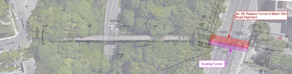
11 Tunnel Design Alternatives Assessment 1. Socio-Economic Environment Amount and type of property required b. Supports existing and future community planning c. d. Potential impact to adjacent residences and business (disruption and nuisance) Ability to address public security needs for all users using CPTED principles: Open sightlines and illuminations for natural surveillance Access control to bridge and tunnel Identification of community space engendering a sense of protectiveness Maintenance and management of facility Socio-Economic Environment Summary Alternative 2A Reconstruct and Widen Tunnel to the West Alternative 2B Reconstruct Tunnel to Match Glen Road Alignment (to the East) No property requirements No property requirements; new tunnel alignment would be within City s right-of-way. Bridge and tunnel connection between Dale Avenue and Glen Road will be maintained. Bridge will be replaced with a new structure. Supports future development and anticipated increase in pedestrian/cyclist traffic with wider tunnel and bridge. Disruption during construction of bridge replacement. Disruption during construction of bridge replacement. Extensive disruption to tunnel and Bloor Street traffic. Extensive disruption to tunnel and Bloor Street traffic. Impacts to parking lot for 451 Glen Road for construction of AODA ramp; parking lot property is owned by the City. A wider tunnel and better lighting would improves sightlines for natural surveillance. Access points to tunnel and bridge remain as existing. Potential to provide sense of community space through aesthetic designs and opportunity for public arts. No property impacts. All alternatives support future community planning. Some disturbance to adjacent residences, businesses and users during construction of tunnel. Improved sightlines between tunnel, bridge, and Glen Road providing natural surveilance addressing public security needs. A wider tunnel and better lighting would improve sightlines for natural surveillance. However, the new aligment of the tunnel would not allow a direct light of sight from the sidewalk of Glen Road south. Access points to tunnel and bridge will be adjusted to relocate staircases and provide ramps. Potential to provide sense of community space through aesthetic designs space and opportunity for public arts. No property impacts. All alternatives support future community planning. More disturbance to adjacent residences, businesses and users during construction of tunnel as staircases also need to be reconstructed north and south of Bloor Street. Reduces sightlines between tunnel, bridge, and Glen Road; does not address public security needs as much as Alternative 1. Alternative 2C Reconstruct Tunnel on New Alignment (match north end of bridge to south end of tunnel) No property requirements; new tunnel alignment would be within City s right-of-way. Disruption during construction of bridge replacement. Extensive disruption to tunnel and Bloor Street traffic. A wider tunnel and better lighting would significanlty improve sightlines for natural surveillance and potential for improved lighting. Access points to tunnel and bridge remain as existing. Landing area north of Bloor Street may result in areas with poor visibility adjacent to stairs Potential to provide sense of community space through aesthetic designs and opportunity for public arts. No property impacts. All alternatives support future community planning. Some disturbance to adjacent residences, businesses and users during construction of tunnel. Improved sightlines between tunnel, bridge, and Glen Road, but creates areas with poor visibility on north side of tunnel. 2. Transportation Planning Addresses existing and future pedestrian and cycling needs b. Maintains/improves network connectivity Bridge will be replaced and new tunnel provides additional width for added capacity of cyclists and pedestrians. Cyclists would have to dismount when across the bridge or tunnel (per existing conditions). Maintains existing network connectivity for pedestrians and cyclists. Maintains existing network connectivity for pedestrians and cyclists. Maintains network connectivity. Creates a slight jog from the north staircase to the bridge/tunnel; survey conducted as part of the EA Study indicated the move between bridge to Bloor Street via the north staircase is the second most used movement in the area (most used movement is between bridge/tunnel to Glen Road). 1
12 Tunnel Design Alternatives Assessment c. Impacts to existing access points d. Reduce conflict points for cross-traffic at south entrance to tunnel (adjacent to TTC Sherbourne Station) Transportation Planning Summary Alternative 2A Reconstruct and Widen Tunnel to the West Maintains existing access points from Glen Road (to the north and south) and Bloor Street. Does not prevent installation of AODA ramp or elevator. Provides better sightlines at conflict points. All alternatives provide for future pedestrian and cyclist needs. Does not impact existing accesses (staircases). Provides good sightlines at points of interest. Does not prevent providing AODA access. Alternative 2B Reconstruct Tunnel to Match Glen Road Alignment (to the East) Existing stair access to/from Bloor Street would be impacted. Relocation of staircases north or south of Bloor Street, would be required, and installation of AODA ramp or elevator. Sightline may be limited from Glen Road sidewalk to the new tunnel entrance All alternatives provide for future pedestrian and cyclist needs. Impacts existing accesses (staircases) north and south of Bloor Street. Reduces sightlines at points of interest from existing conditions. Requires providing AODA accesses. Alternative 2C Reconstruct Tunnel on New Alignment (match north end of bridge to south end of tunnel) Maintains existing access points from Glen Road (to the north and south) and Bloor Street. Does not prevent installation of AODA ramp or elevator. Provides better sightlines at conflict points. All alternatives provide for future pedestrian and cyclist needs. Does not impact existing accesses (staircases). Provides good sightlines at points of interest. Does not prevent providing AODA access. 3. Natural Environment Potential impacts to existing natural environmental features including: Vegetation Wildlife Impacts to natural environment around replacement of bridge. Additional natural impacts around north tunnel entrance with additional landing are Impacts to natural environment around replacement of bridge. Additional natural impacts around north tunnel entrance with additional landing area and new alignment of the tunnel. Impacts to additional natural environment around replacement of bridge due to new alignment of bridge over the Rosedale Valley. Natural Environment Summary 4. Structural Engineering Structural Improvements (Capacity, Service Life, Deficiencies etc.) b. Potential Utility Impacts c. Constructability (Constraints and Complexity) Addresses structural improvements for the tunnel. The new tunnel is expected to have a service life of about 75 years. Potential impacts to utilities on west side of the existing tunnel including gas and sanitary. Utilities would be relatively the least amongst the three alternatives. May require temporary bypass pumping for utility replacement. Work can be completed using conventional methods. Relatively moderate complexity due to utility impacts (west of existing tunnel only) and traffic staging on Bloor Street; generally maintaining existing tunnel alignment. Potential impacts to utilities on east side of the existing tunnel including sanitary, two gas lines, and water main. Utilities impact most significant under this alternative. May require temporary bypass pumping for utility replacement. Work can be completed using conventional methods. Relatively high complexity due to utility impacts and traffic staging on Bloor Street on new tunnel alignment. Potential impacts to utilities on west side of the existing tunnel including gas and sanitary. Utilities relative more than Alternative 2A but less than 2B. May require temporary bypass pumping for utility replacement. Work can be completed using conventional methods. Relatively high complexity due to utility impacts and traffic staging on Bloor Street. Minor adjustments to bridge landing at north end due to new alignment. 2
13 Tunnel Design Alternatives Assessment d. Construction Staging (Duration, Risk Complexity, Traffic Impacts, etc.) Structural Engineering Summary Alternative 2A Reconstruct and Widen Tunnel to the West Moderately complex staging requirements for tunnel replacement including traffic impacts on Bloor Street. Roadway protection system and shoring required. Relatively low risk as most construction will be focused on existing tunnel location. Tunnel closure required during construction of bridge and tunnel. Minimal impacts to existing utilities. Conventional construction and staging methods. Alternative 2B Reconstruct Tunnel to Match Glen Road Alignment (to the East) Major staging requirements for tunnel replacement including Bloor Street. Roadway protection system and shoring required for building new tunnel. Relatively high risk as construction of tunnel in new location with multiple crossing utility lines. Tunnel closure required during construction of bridge; potential to maintain existing tunnel during majority of construction. Higher potential of impacting existing utilities on east side of tunnel. Complex construction and staging methods due to required replacement of tunnel and staircases. Alternative 2C Reconstruct Tunnel on New Alignment (match north end of bridge to south end of tunnel) Major staging requirements for tunnel replacement including Bloor Street. Roadway protection system and shoring required. Relatively moderate risk as most construction will be focused on existing tunnel location. Tunnel closure required during construction of bridge and tunnel. Minimal impacts to existing utilities. Medium complexity of construction and staging, as replacing tunnel on new alignment. 5. Urban Design b. Potential to provide improved design for bridge or tunnel Potential improvement of landing areas at access points Urban Design Summary Provides potential for enhanced aesthetic improvements to the new and wider tunnel, opportunities for public art, etc. Provides additional space for landing area north and south of tunnel for enhanced designs. Potential reconstruction of north bridge access to allow cyclists on bridge. Provides potential for enhanced aesthetic improvements to the new and wider tunnel, opportunities for public art, etc. Existing wildflower garden potentially removed due to installation of accessible ramps. Provides additional space for landing area north and south of tunnel for enhanced designs. Some additional opportunities available with relocation of staircases. Potential reconstruction of north bridge access to allow cyclists on bridge. Provides potential for enhanced aesthetic improvements to the new and wider tunnel opportunities for public art, etc. Provides additional space for landing area north and south of tunnel for enhanced designs. Potential reconstruction of north bridge access to allow cyclists on bridge. 6. Cost Comparative costs including: capital construction, operation/ maintenance, contingency, etc. (Remaining service life of tunnel is 20 years) *See Tunnel Cost Schedule for life cycle assessment Net present day value for tunnel reconstruction - $4.16 M Tunnel reconstruction - $5.10 M Additional cost for new staircases and alternate access to Bloor Street Net present day value for tunnel reconstruction on new alignment - $5.10 M Cost Summary 7. Cultural Environment Impacts to cultural heritage resources Bridge type View from Rosedale Valley View from bridge deck All alternatives provide opportunity to maintain the heritage value of the bridge by allowing for any bridge type, including the inclined steel leg. All alternatives would require some changes to the structural design and connection to the tunnel landing are All alternatives maintain the existing connection to Rosedale neighbourhood. 3
14 Tunnel Design Alternatives Assessment Alternative 2A Reconstruct and Widen Tunnel to the West b. Archaeology No archaeological potential. Alternative 2B Reconstruct Tunnel to Match Glen Road Alignment (to the East) Alternative 2C Reconstruct Tunnel on New Alignment (match north end of bridge to south end of tunnel) Cultural Environment Summary Summary Alternative 2A would address the existing security issues associated with the tunnel by providing additional lighting, and a more comfortable environment with a wider tunnel. Based on the sightline assessment, the additional tunnel width would provide some enhancement to the sightlines between the tunnel, the bridge, and Glen Road. Widening the tunnel to the west minimizes the potential utility impacts. This alternative could be combined with Alternative 2 as part of a phased approach. Alternative 2B would not address the existing security issues associated with the tunnel, as it reduces the sightlines between the tunnel and the Glen Road sidewalk. Staircases on both the north and south side will be impacted and will have to be reconstructed. This alternative would have the most impacts to utilities, most complex in constructability and the highest cost. Alternative 2C would address the existing security issues associated with the tunnel by providing additional lighting, and a more comfortable environment with a wider tunnel. Based on the sightline assessment, aligning the bridge and tunnel provides the best sightlines; however, this alternative also create spaces where there would be poor visibility. By realigning the tunnel away from the north staircase, a jog is created between the bridge/tunnel and staircase. Alternative 2C would also have more footprint impacts in the valley and utilities impact compared to Alternative 2B. Preferred Not Preferred Not Preferred Least Impact/ Most Benefit Most Impact/ Least Benefit 4

15 Tunnel Design Alternatives Assessment 5

16 Tunnel Design Alternatives Assessment 6
GLEN ROAD PEDESTRIAN BRIDGE ENVIRONMENTAL ASSESSMENT STUDY PUBLIC INFORMATION CENTRE #2 OCTOBER 24, 2017
 GLEN ROAD PEDESTRIAN BRIDGE ENVIRONMENTAL ASSESSMENT STUDY PUBLIC INFORMATION CENTRE #2 OCTOBER 24, 2017 Glen Road Pedestrian Bridge Class Environmental Assessment 1 WELCOME! Welcome to the second Public
GLEN ROAD PEDESTRIAN BRIDGE ENVIRONMENTAL ASSESSMENT STUDY PUBLIC INFORMATION CENTRE #1 SEPTEMBER 28, 2016
 GLEN ROAD PEDESTRIAN BRIDGE ENVIRONMENTAL ASSESSMENT STUDY PUBLIC INFORMATION CENTRE #1 SEPTEMBER 28, 2016 Glen Road Pedestrian Bridge Class Environmental Assessment WELCOME! Welcome to the first Public
Glen Road Pedestrian Bridge Environmental Assessment
 Glen Road Pedestrian Bridge Environmental Assessment Presentation to Design Review Panel July 18, 2017 Glen Road Pedestrian Bridge Class Environmental Assessment STUDY AREA Bloor Street East Streetscape
Victoria Bridge Municipal Class EA Civic Works Committee
 Municipal Class EA John Pucchio, P. Eng., Project Manager June 19 2018 Introduction Existing Conditions Municipal Class EA Proposed Bridge Proposed Road Reconstruction Proposed Improvements Construction
The purpose of tonight s PIC is to:
 The purpose of tonight s PIC is to: Provide an overview of the work completed to date and a summary of the Class EA process being followed; Provide a summary of public input received so far, including
Adelaide Street / Canadian Pacific Railway (CPR) Grade Separation Class Environmental Assessment. Public Information Centre 3
 Grade Separation Class Environmental Assessment. Public Information Centre 3") 1 Adelaide Street / Canadian Pacific Railway (CPR) Grade Separation Study Process and Purpose of PIC 3 2 Study Commencement February 2016 Phase 1: Problem and Opportunity Identify problems and opportunities
1 Adelaide Street / Canadian Pacific Railway (CPR) Grade Separation Study Process and Purpose of PIC 3 2 Study Commencement February 2016 Phase 1: Problem and Opportunity Identify problems and opportunities
Municipal Class EA Study Public Information Centre No. 1 December 13, :00 pm 7:00 pm. Please sign in so we can keep you updated on this study
 Reconstruction of Regional Road 45 (Creek Road) Between Regional Road 27 (River Road) and Regional Road 63 (Canborough Road) in the Township of Wainfleet Municipal Class EA Study Public Information Centre
GLEN ROAD PEDESTRIAN BRIDGE AND TUNNEL ENVIRONMENTAL ASSESSMENT STUDY
 GLEN ROAD PEDESTRIAN BRIDGE AND TUNNEL ENVIRONMENTAL ASSESSMENT STUDY ENVIRONMENTAL STUDY REPORT GLEN ROAD PEDESTRIAN BRIDGE AND TUNNEL ENVIRONMENTAL ASSESSMENT STUDY ENVIRONMENTAL STUDY REPORT PROJECT
WELCOME TO OPEN HOUSE TWO November 28, 2018
 Langstaff Road Weston Road to Highway 7 Class Environmental Assessment Study WELCOME TO OPEN HOUSE TWO November 28, 2018 Please sign in and join our mailing list Study Overview York Region is conducting
Public Meeting #3 May 9, 2009 MVVA Team
 Public Meeting #3 May 9, 2009 MVVA Team Welcome to the third Public Meeting for the Lower Don Lands Municipal Class Environmental Assessment (EA) Infrastructure Master Plan and Keating Channel Precinct
Purpose of Open House #3
 Public Meeting #3 May 9, 2009 MVVA Team Purpose of Open House #3 The main purpose of this Open House is to present and seek input on the: Evaluation of transportation and infrastructure design alternatives
St. Clair Avenue West Area Transportation Master Plan
 1 (Between Keele Street and Old Weston Road) Public Information Centre 1 December 2, 2015 2 Welcome Welcome to the first Public Information Centre for the St. Clair Avenue West Area. The panels will present
Public Information Centre. Welcome
 Transportation Improvements from the Beaver Creek Bridge to the Entrance of Santa s Village District of Muskoka Municipal Class Environmental Assessment Welcome Please sign in Take a comment sheet Staff
Bostwick Road. Municipal Class Environmental Assessment. Public Information Centre #2 June 14, City of London
 Bostwick Road Municipal Class Environmental Assessment Public Information Centre #2 June 14, 2017 Welcome! Welcome to the 2 nd Public Information Centre for the. Representatives from the and the consulting
Commissioners Road West Realignment Environmental Assessment
 City of London Commissioners Road West Realignment Environmental Assessment Public Information Centre No. 1 March 30, 2017 Welcome to the Public Information Centre This first Public Information Centre
Second Line West Pedestrian/Cyclist Crossing of Highway 401 Class EA. Second Line West Pedestrian/Cyclist Crossing of Highway 401 Class EA
 1 1 Purpose of Public Information Centre #2 To provide interested and/or potentially affected stakeholders with an opportunity to participate in the planning and decision-making process for this Municipal
Municipal Heritage Bridges Cultural, Heritage and Archaeological Resources Assessment Checklist Revised April 11, 2014
 Municipal Heritage Bridges Cultural, Heritage and Archaeological Assessment Checklist Revised April 11, 2014 This checklist was prepared in March 2013 by the Municipal Engineers Association to assist with
Recreational Pathway Crossing of Richmond Street Municipal Class Environmental Assessment. Public Information Centre #2 April 22, 2015
 Recreational Pathway Crossing of Richmond Street Municipal Class Environmental Assessment Public Information Centre #2 April 22, 2015 1. Study Process PHASE 1 PHASE 2 PHASE 3 PHASE 1 : Problem/Opportunity
Victoria Street Pedestrian Bridge
 Township of Centre Wellington Victoria Street Pedestrian Bridge Class Environmental Assessment County of Wellington & Township of Centre Wellington Badley Bridge Replacement/Rehabilitation (County of Wellington),
ROAD CONSTRUCTION. 36 June 2014 ROADS&BRIDGES
 ROAD CONSTRUCTION 36 June 2014 ROADS&BRIDGES Young is full of life Recent expansion completes continuous, multilane arterial By Donald Hammack, P.E. Contributing Author The Florida Department of Transportation
SCARBOROUGH RAPID TRANSIT ENVIRONMENTAL PROJECT REPORT CHAPTER 2 PROJECT DESCRIPTION. Table 2-4: North Segment Alignment Analysis 2-21
 Table 2-4: North Segment Alignment Analysis 2-21 SCARBOROUGH RAPID TRANSIT Based on the above analysis (detailed analysis is contained in Appendix A-4), North Alignment 3 is preferred because it: Has the
Mavis Road Class Environmental Assessment
 Mavis Road Class Environmental Assessment Public Information Centre #2 Wednesday November 9, 2016 6:00 to 8:00 p.m. Please sign in and complete a comment sheet Review the displays on your own or join in
WELCOME TO THE PUBLIC INFORMATION CENTRE. Please Sign In
 WELCOME TO THE PUBLIC INFORMATION CENTRE Replacement of Oxtongue Lake Narrows Bridge & Oxtongue River Bridge, Highway 60 (G.W.P. 93-89-00 & G.W.P. 5550-04-00) Class Environmental Assessment (Group B) Please
FANSHAWE PARK ROAD/RICHMOND STREET INTERSECTION IMPROVEMENTS. PUBLIC INFORMATION CENTRE 2 June 16, 2016
 FANSHAWE PARK ROAD/RICHMOND STREET INTERSECTION IMPROVEMENTS Municipal Class Environmental Assessment PUBLIC INFORMATION CENTRE 2 June 16, 2016 ACCESSIBILITY Under the Accessibility Standards 2015 for
Blackfriars Bridge Municipal Class Environmental Assessment. Public Information Centre #1 November 19 th, 2014
 Blackfriars Bridge Municipal Class Environmental Assessment Public Information Centre #1 November 19 th, 2014 Why are you here tonight? To determine the future requirements of the river crossing at Blackfriars
6 BRIDGES. 6.1 Design philosophy. Proposed bridges
 SECTION 6 BRIDGES 6 BRIDGES Throughout the Project, bridges are a key visual element and marker for road users, pedestrians and cyclists. The design of bridges, as with other visible structures, has been
WELCOME TO PUBLIC INFORMATION CENTRE #2. Please Sign In
 WELCOME TO PUBLIC INFORMATION CENTRE #2 Replacement of Oxtongue Lake Narrows Bridge & Oxtongue River Bridge, Highway 60 (G.W.P. 93-89-00 & G.W.P. 5550-04-00) Class Environmental Assessment (Group B) Please
Workshop 3. City of Burlington Waterfront Hotel Planning Study. September 14, The Planning Partnership
 Workshop 3 City of Burlington Waterfront Hotel Planning Study September 14, 2017 The Planning Partnership The Waterfront Hotel Planning Study 01 The Brant & Lakeshore Planning Study will establish a Strategic
ONLINE PUBLIC INFORMATION CENTRE
 ONLINE PUBLIC INFORMATION CENTRE County Road 17 Bridge Replacements Detail Design and Environmental Assessment GWP 4203-15-00 The Ministry of Transportation Ontario (MTO) has retained CH2M Hill and Dillon
Baby Point Wastewater Pumping Station Forcemain Class Environmental Assessment Study
 Baby Point Wastewater Pumping Station Forcemain Class Environmental Assessment Study Public Drop-in Event 1 Thursday, October 12, 2017 6:00 p.m. to 8:00 p.m. Humbercrest United Church Welcome Welcome to
TRANSPORTATION COMMITTEE
 TRANSPORTATION COMMITTEE CITY OF OTTAWA Ministry of Transportation Detailed Design Assignment G.W.P.# 4058-01-00 Highway 417 (Ottawa Queensway) Widening & Rehabilitation from Maitland Avenue to Island
Evaluation Criteria. Detailed Evaluation Criteria
 Evaluation Criteria Detailed Evaluation Criteria Community Well-being A safe and socially inclusive service that improves access to key community destinations and provides transportation choices for Calgarians.
CHAIR AND MEMBERS CIVIC WORKS COMMITTEE MEETING ON JUNE 19, 2018
 TO: FROM: SUBJECT: CHAIR AND MEMBERS CIVIC WORKS COMMITTEE MEETING ON JUNE 19, 2018 KELLY SCHERR, P. ENG., MBA, FEC MANAGING DIRECTOR, ENVIRONMENTAL & ENGINEERING SERVICES AND CITY ENGINEER VICTORIA BRIDGE
1 Metrolinx overview. Mission We connect our communities. Vision Getting you there better, faster and easier
 Mission We connect our communities Vision Getting you there better, faster and easier Values Play as a team Think forward Serve with passion 1 Metrolinx overview go transit, up express, presto Serve a
Update. What is the Osborne Bridge Rehabilitation project all about and how is it being planned? Neighbourhood Advisory Committee (NAC)
") Update JANUARY 2010 Neighbourhood Advisory Committee (NAC) ARTS AND CULTURE Gas Station Theatre BUSINESS Osborne Village BIZ Downtown BIZ COMMERCIAL PROPERTY OWNER Great-West Life COMMUNITY ORGANIZATIONS
Update JANUARY 2010 Neighbourhood Advisory Committee (NAC) ARTS AND CULTURE Gas Station Theatre BUSINESS Osborne Village BIZ Downtown BIZ COMMERCIAL PROPERTY OWNER Great-West Life COMMUNITY ORGANIZATIONS
Bostwick Road. Municipal Class Environmental Assessment. October 13, City of London. Bostwick Road Municipal Class Environmental Assessment
 Bostwick Road Municipal Class Environmental Assessment October 13, 2016 Welcome! Welcome to the first Public Information Centre for the Bostwick Road Municipal Class Environmental Assessment. Representatives
GEOMETRIC IMPROVEMENTS AND WATERMAIN LOOPING MUNICIPAL CLASS ENVIRONMENTAL ASSESSMENT
 GEOMETRIC IMPROVEMENTS AND WATERMAIN LOOPING MUNICIPAL CLASS ENVIRONMENTAL ASSESSMENT Veterans Way (previously Powerline Road) and Klondike Park Road Wasaga Beach Welcome Please sign in Take a comment
WELCOME TO OPEN HOUSE # 3
 Bayview Avenue Class Environmental Assessment Study Steeles Avenue to Elgin Mills Road WELCOME TO OPEN HOUSE # 3 Please sign in and join our mailing list Why Are We Here Tonight? Study Process and Purpose
City of Toronto. Emery Village Transportation Master Plan
 City of Toronto Emery Village Transportation Master Plan May 2009 Emery Village Transportation Master Plan Toronto, ON May 2009 Consulting Inc. 100 York Blvd., Suite 300 Richmond Hill, ON L4B 1J8 Tel:
DESIGN OF FOOTBRIDGES
 Civil Engineering Technical Requirement CIVIL-SR-006 DESIGN OF FOOTBRIDGES Revision: 9 Updated: 26/08/2015 Queensland Rail 2015 Reproduction by any means (including electronic, mechanical, photocopying,
I-90 Mississippi River Bridge & Interchange Project
 I-90 Mississippi River Bridge & Interchange Project Presentation Outline I. Background: Context & Need for Project II. Preferred Alternative Overview III. Project Development IV. Project Management Tools
COUNCIL ATTACHMENT 2 HIGHWAY 7 CORRIDOR AND VAUGHAN NORTH-SOUTH LINK
 COUNCIL ATTACHMENT 2 HIGHWAY 7 CORRIDOR AND VAUGHAN NORTH-SOUTH LINK Welcome! The purpose today is to: Present the Study Background; Describe Alignment Alternatives Analyzed; Present the Evaluation of
Adelaide Street / Canadian Pacific Railway (CPR) Grade Separation. Public Information Centre #1
 Grade Separation. Public Information Centre #1") 1 Adelaide Street / Canadian Pacific Railway (CPR) Why Are We Here? 2 The purpose of Public Information Centre (PIC) #1 is to: Introduce the study Provide the study background and context Identify the
1 Adelaide Street / Canadian Pacific Railway (CPR) Why Are We Here? 2 The purpose of Public Information Centre (PIC) #1 is to: Introduce the study Provide the study background and context Identify the
Northeast Anthony Henday Drive Manning Freeway to Whitemud Drive Welcome to this Construction Information Session
 Manning Freeway to Whitemud Drive Welcome to this Construction Information Session Purpose To inform interested residents and businesses about the plans accommodation. Background: The Government of Alberta
Portage Parkway Environmental Assessment Public Information Centre No. 1
 City of Vaughan Portage Parkway Environmental Assessment Public Information Centre No. 1 November 25, 2015 Welcome to the Public Information Centre This first Public Information Centre (PIC) introduces
Welcome. Green Line LRT. Beltline Alignment Options. Stay engaged! Follow the Green Line story at calgary.ca/greenline
 Welcome Green Line LRT Beltline Alignment Options Stay engaged! Follow the Green Line story at calgary.ca/greenline Green Line LRT Why are we here? Our Challenge Determine the best alignment in the Beltline.
Christine Toner, Consultation Leader
 9. FAIRVIEW STREET FOOTBRIDGE REBUILD General Manager responsible: General Manager, City Environment Group, DDI 941-8608 Officer responsible: Unit Manager, Transport and Greenspace Author: Christine Toner,
New. Stations. Smart Track I tlo MTDRONIO. Public Information Centre
 Public Information Centre New Smart Track I tlo - - -E>- - Stations Public Information Centre. King-Liberty SmartTrack Station. St. Clair-Old Weston SmartTrack Station. Spadina-Front GO Station. Bloor-Lansdowne
Reconfiguration of The Six Points Interchange. Community Update #2 June 18, 2014
 Reconfiguration of The Six Points Interchange Community Update #2 June 18, 2014 Outline 1. Project overview 2. How did we get here? 3. Etobicoke Centre 4. Existing and future road network 5. Design Update
112th Avenue Light Rail Options Concept Design Report JUNE 2010 PREPARED FOR PREPARED BY TBG PGH
 112th Avenue Light Rail Options Concept Design Report JUNE 2010 PREPARED FOR PREPARED BY TBG060310124909PGH C ontents Introduction 1 Project Overview 1 Public Involvement and Technical Coordination 4 Description
North York Centre South Service Road
 North York Centre South Service Road Municipal Class Environmental Assessment Addendum Potential Changes to Doris Avenue, Bonnington Place & Tradewind Avenue Study Summary (June 11, 2015) toronto.ca/nyc-south-road.
(blank page) WestConnex New M Roads and Maritime Services Environmental impact statement
 WestConnex New M Roads and Maritime Services Environmental impact statement") (blank page) WestConnex New M5 5-42 (blank page) WestConnex New M5 5-44 5.5 Tunnels 5.5.1 Main alignment tunnels The main alignment tunnels would be about nine kilometres long, with the western tunnel
(blank page) WestConnex New M5 5-42 (blank page) WestConnex New M5 5-44 5.5 Tunnels 5.5.1 Main alignment tunnels The main alignment tunnels would be about nine kilometres long, with the western tunnel
Bloor Street East Potential Ravine Portal Overlook and Access Passage to the Rosedale Valley and Don River Valley Ravine, Toronto, Canada
 TRANSFORMATIVE IDEA 2. GREAT STREETS Bloor Street Christie Pits Park Bloor St Spadina Ave Bathurst St Shaw St 1 Recognize the significant public realm improvements along Bloor Street and extend and enhance
Chapter 10 Route window W17 Middlegreen Road, St Mary s Road and Trenches bridges. Transport for London
 Chapter 10 Route window W17 Middlegreen Road, St Mary s Road and Trenches bridges Transport for London MIDDLEGREEN ROAD, ST MARY S ROAD AND TRENCHES BRIDGES 10 Route window W17 Middlegreen Road, St Mary
Pedestrian Project Award Institute of Transportation Engineers
 Pedestrian Project Award Institute of Transportation Engineers Rideau Canal Pedestrian Crossing Planning and Environmental Assessment Report The Setting The Rideau Canal and its adjacent pathways are highly
Derby-Shelton Bridge Pedestrian and Bicyclist Enhancements [1]
![Derby-Shelton Bridge Pedestrian and Bicyclist Enhancements [1]](/thumbs/96/128011958.jpg "Derby-Shelton Bridge Pedestrian and Bicyclist Enhancements [1]") nhancements [1] STATUS OF PROJECT: The project has recently moved from the Preliminary Design Phase to the Final Design Phase following the most recent Public Involvement Meeting held on January 9, 2019
nhancements [1] STATUS OF PROJECT: The project has recently moved from the Preliminary Design Phase to the Final Design Phase following the most recent Public Involvement Meeting held on January 9, 2019
Relief Line Project Assessment
 Relief Line Project Assessment Public Information Centre April 5, 2017 Tonight s Meeting PURPOSE To review the preferred alignment for the Local Segment. AGENDA 6:30 Open House 7:00 Presentation / Discussion
Welcome. Mill Creek Ravine Pedestrian Bridges Rehabilitation. Public Information Session #1. Thursday, October 27, :00 8:00 p.m.
 Welcome Mill Creek Ravine Pedestrian Bridges Rehabilitation Public Information Session #1 Thursday, October 27, 2016 5:00 8:00 p.m. Tonight you can: Learn about the rehabilitation of 5 pedestrian bridges
CHAPTER 5: GUIDING PRINCIPLES
 CHAPTER 5: GUIDING PRINCIPLES The following 10 principles were developed based on public consultation, planning policy and the background analysis conducted during Phase 1. The Guiding Principles significantly
Main Street Reconstruction From Ninth Line to Stouffer Street. Town of Whitchurch-Stouffville. Public Information Centre
 Main Street Reconstruction From Ninth Line to Stouffer Street Town of Whitchurch-Stouffville Public Information Centre November 23, 2016 4:30 to 6:00 pm & 7:00 to 8:00 pm 6240 Main Street, Stouffville
Toronto Complete Streets Guidelines
 Toronto Complete Streets Guidelines 108 110 7.1 Green Infrastructure Design Principles 112 7.2 Context-Sensitive Green Streets 114 7.3 Key Green Street Elements Green infrastructure refers to natural and
5.8 Visual Resources and Aesthetic Qualities
 I-70 East Supplemental Draft EIS 5.8 Visual Resources and Aesthetic Qualities 5.8 Visual Resources and Aesthetic Qualities This section discusses the visual resources and aesthetic qualities of the study
Southern Gateway Project and Public Green
 Southern Gateway Project and Public Green Transportation and Trinity River Project Committee May 23, 2016 Purpose of Presentation Provide the history and an overview of the Southern Gateway Project (SGP)
Clay Street Bridge Replacement Project
 Clay Street Bridge Replacement Project Frequently Asked Questions (FAQs) No. 2 April 4, 2018 The project is located in downtown Placerville on Clay Street between US Highway 50 and Main Street and Cedar
Views from the Bridge
 Chapter 2 Views from the Bridge Alternative 2A would primarily have adverse visual impacts to views from the Bridge, with the exception of a strongly adverse visual impact from Viewpoint 11 (Car View East)
I-84 HARTFORD PROJECT HARTFORD, CONNECTICUT DRAFT PURPOSE AND NEED STATEMENT
 I-84 HARTFORD PROJECT HARTFORD, CONNECTICUT DRAFT PURPOSE AND NEED STATEMENT October 2016 I. PROJECT BACKGROUND AND HISTORY The City of Hartford is the capital of Connecticut, and the largest employment
WELCOME! 8 8:30 6: TH STREET IMPROVEMENTS. Open House. Presentation & Q&A
 WELCOME! 168 TH STREET IMPROVEMENTS 6:30 Open House 7 8 Presentation & Q&A 8 8:30 Open House WELCOME Todd Pfitzer City of Omaha Engineer Bob Stubbe City of Omaha Public Works Director Jon Meyer Project
City of Grande Prairie Development Services Department
 City of Grande Prairie Development Services Department ROYAL OAKS NORTH OUTLINE PLAN OP-07-03 NW 35-71-6 W6M May 7, 2007 Royal Oaks North Outline Plan TABLE OF CONTENTS 1.0 INTRODUCTION........ 3 1.1 Purpose
HERITAGE IMPACT ASSESSMENT SALEM BRIDGE, COUNTY SITE No. B IRVINE CREEK (LOTS 15 & 16, CONCESSION 11 GEOGRAPHIC TOWNSHIP OF NICHOL)
") HERITAGE IMPACT ASSESSMENT SALEM BRIDGE, COUNTY SITE No. B018050 IRVINE CREEK (LOTS 15 & 16, CONCESSION 11 GEOGRAPHIC TOWNSHIP OF NICHOL) WOOLWICH STREET WEST (WR 18) SALEM, TOWNSHIP OF CENTRE WELLINGTON
HERITAGE IMPACT ASSESSMENT SALEM BRIDGE, COUNTY SITE No. B018050 IRVINE CREEK (LOTS 15 & 16, CONCESSION 11 GEOGRAPHIC TOWNSHIP OF NICHOL) WOOLWICH STREET WEST (WR 18) SALEM, TOWNSHIP OF CENTRE WELLINGTON
Page. I. Introduction 1. II. Project Purpose and Need 2. IV. Description of Section 4(f) Property 2. V. Impacts to Section 4(f) property 3
 Property 2. V. Impacts to Section 4(f) property 3") Table of Contents Programmatic Section 4(f) Evaluation for use of a Historic Bridge Replacement of Route 30/130 Bridge over the Cooper River Structure No. 0405-153 City of Camden, Borough of Collingswood,
Table of Contents Programmatic Section 4(f) Evaluation for use of a Historic Bridge Replacement of Route 30/130 Bridge over the Cooper River Structure No. 0405-153 City of Camden, Borough of Collingswood,
Chapter 27 Route Window SE7 Church Manorway Bridge. Transport for London
 Chapter 27 Route Window SE7 Church Manorway Bridge Transport for London CHURCH MANORWAY BRIDGE 27 Route Window SE7 Church Manorway bridge Introduction 27.1 The North Kent Line will be converted to four
Visual and Aesthetic Resources
 Visual and Aesthetic Resources 7.1 INTRODUCTION This chapter evaluates the effects of the Modified Design on visual and aesthetic resources, in comparison to the effects of 2004 FEIS Design. The 2004 FEIS
Alterations to a Designated Heritage Property and Authority to Amend a Heritage Easement Agreement Queen's Park
 REPORT FOR ACTION Alterations to a Designated Heritage Property and Authority to Amend a Heritage Easement Agreement - 100 Queen's Park Date: April 27, 2017 To: Toronto Preservation Board Toronto and East
Memo. B R A Y H e r i t a g e
 6 1 3. 5 4 2. 3 3 9 3 6 1 3. 5 4 9. 6 2 3 1 c a r l @ b r a y h e r i t a g e. c o m Memo To: Jennifer Murray, Windmill Development Corporation From: Carl Bray, Bray Heritage Date: Monday, June 5, 2017
The Master Plan Framework
 The Master Plan Framework The East Harbour Master Plan advances the development of 60 acres of former industrial lands east of the Don River. The Master Plan outlines a vision for a vibrant, transit-oriented
Century Park to Ellerslie Road Preliminary Engineering
 Century Park to Ellerslie Road Preliminary Engineering South LRT Extension Stakeholder Information Panel Brochure March 2010 www.edmonton.ca/lrtprojects LRT Station (left) and Transit Centre Architectural
TOWN OF AURORA HERITAGE IMPACT ASSESSMENTS AND CONSERVATION PLANS GUIDE
 PLANNING AND DEVELOPMENT SERVICES Development Planning Division Heritage Planning Section Phone: 905-727-3123 ext. 4226 Fax: 905-726-4736 Email: planning@aurora.ca Town of Aurora 100 John West Way, Box
Commissioners Road West Realignment Environmental Assessment
 City of London Commissioners Road West Realignment Environmental Assessment Public Information Centre No. 2 November 29, 2017 Welcome to the Public Information Centre This 2 nd Public Information Centre
City of Edmonton Valley Line Stage 1 Light Rail Transit (LRT) Project Site Location Study Update
 Project Site Location Study Update") Attachment 2 City of Edmonton Valley Line Stage 1 Light Rail Transit (LRT) Project Site Location Study Update Final Report Prepared for: LRT D and C Transportation Services City of Edmonton Edmonton, Alberta
Attachment 2 City of Edmonton Valley Line Stage 1 Light Rail Transit (LRT) Project Site Location Study Update Final Report Prepared for: LRT D and C Transportation Services City of Edmonton Edmonton, Alberta
SOUTHWEST CORRIDOR EXTENSION. Environmental Evaluation and Basic Engineering Results PUBLIC MEETING/OPEN HOUSE November 18, 2009
 SOUTHWEST CORRIDOR EXTENSION Environmental Evaluation and Basic Engineering Results PUBLIC MEETING/OPEN HOUSE November 18, 2009 AGENDA I. Welcome/Introductions II. Project Review and Status III. Environmental
PROPOSED REDEVELOPMENT OF THE GLEN ABBEY GOLF CLUB. STREETSCAPE DESIGN STUDY (excerpt from the Urban Design Brief) TOWN OF OAKVILLE.
 TOWN OF OAKVILLE.") PROPOSED REDEVELOPMENT OF THE GLEN ABBEY GOLF CLUB STREETSCAPE DESIGN STUDY (excerpt from the Urban Design Brief) TOWN OF OAKVILLE OCTOBER, 2016 for 2.4.2 STREETS Streets are the single largest component
PROPOSED REDEVELOPMENT OF THE GLEN ABBEY GOLF CLUB STREETSCAPE DESIGN STUDY (excerpt from the Urban Design Brief) TOWN OF OAKVILLE OCTOBER, 2016 for 2.4.2 STREETS Streets are the single largest component
Intention to Designate under Part IV, Section 29 of the Ontario Heritage Act 844 Don Mills Road and 1150 Eglinton Avenue East
 STAFF REPORT ACTION REQUIRED Intention to Designate under Part IV, Section 29 of the Ontario Heritage Act 844 Don Mills Road and 1150 Eglinton Avenue East Date: September 7, 2016 To: From: Toronto Preservation
Welcome. to the 95th Street Terminal Improvement Project Public Hearing
 Welcome to the 95th Street Terminal Improvement Project Public Hearing The purpose of this Public Hearing is to solicit comments from the community about the Environmental Assessment prepared for the 95th
Emery Village Road 2A Municipal Class Environmental Assessment Study
 PW12.11 STAFF REPORT ACTION REQUIRED Emery Village Road 2A Municipal Class Environmental Assessment Study Date: March 30, 2016 To: From: Wards: Reference Number: Public Works and Infrastructure Committee
GUIDELINES EXHIBITION PLACE LOCATION: OBJECTIVES. Structure Plan URBAN DESIGN GUIDELINES
 Development in the Exhibition Place lands will be consistent with the following urban design guidelines. They provide a framework for new development of the lands and are to be read in conjunction with
GUIDELINES WESTON LOCATION: URBAN DESIGN GUIDELINES
 Development in the Weston area will be consistent with the following urban design guidelines. The guidelines correspond to Site and Area Specific Policies 45, 46, 47, 48, 49, 51, 52 and 232 in Chapter
Pedestrian and Cycle Bridge Feasibility Study Report Summary
 Pedestrian and Cycle Bridge Feasibility Study Report Summary For London Borough of Richmond July 2018 OBJECTIVES The primary objective of introducing a new bridge across the Thames in Richmond is to improve
38 Queen s University Campus Master Plan Part 1
 38 Queen s University Campus Master Plan Part 1 46 The Campus at the City Scale Chapter 4 The Campus at the City Scale 39 Queen s is an urban University centrally located in Kingston. Decisions made by
City of Edmonton. Walterdale Bridge Replacement and Approach Roads Evaluation. Concept Planning Study. Final Report
 City of Edmonton Final Report Walterdale Bridge Replacement and Approach Roads Evaluation April, 2011 Walterdale Bridge Replacement and Approach Roads Evaluation Final Report April 2011 Acknowledgement
Highway 427 Industrial Secondary Plan Area 47 Schedule C Class Environmental Assessment For Arterial Roadways
 Welcome to Pubic Information Centre #1 Highway 427 Industrial Secondary Plan Area 47 Schedule C Class Environmental Assessment For Arterial Roadways Welcome to Open House # 1 Tonight, we invite you to.
5: Cross Avenue Bridge, Sixteen Mile Creek Rail Bridge
 1. Description of Property Municipal Address Name (if applicable) Legal Description Location of Property Ownership Access Current Use Existing Designation General Description Priority Level 5: Cross Avenue
Wellington County Badley Bridge Replacement/Rehabilitation Environmental Assessment (EA)Study Welcome
Study Welcome") Wellington County Badley Bridge Replacement/Rehabilitation Environmental Assessment (EA)Study Welcome Welcome to the first Public Information Centre (PIC) meeting. Please record your attendance and obtain
Wellington County Badley Bridge Replacement/Rehabilitation Environmental Assessment (EA)Study Welcome Welcome to the first Public Information Centre (PIC) meeting. Please record your attendance and obtain
Project Purpose. Project Need
 Project Purpose The purpose of the project is to implement a bridge improvement solution that corrects the existing safety problem at the Strasburg Pike Bridge. The project will provide a structurally
Better Cycling. The City will update the cycling master plan (London ON Bikes) based on the approved BRT network.
 based on the approved BRT network.") Better Cycling Dedicated bike facilities will be constructed along BRT corridors where space is available. Nearby bike routes will also be upgraded to ensure a complete network is available for cyclists.
Better Cycling Dedicated bike facilities will be constructed along BRT corridors where space is available. Nearby bike routes will also be upgraded to ensure a complete network is available for cyclists.
Urban Design Manual PLANNING AROUND RAPID TRANSIT STATIONS (PARTS) Introduction. Station Study Areas
 Introduction. Station Study Areas") 111111 PLANNING AROUND RAPID TRANSIT STATIONS (PARTS) Introduction The ION rapid transit system will link Waterloo, Kitchener and Cambridge through a central transit corridor (CTC). There are a number
111111 PLANNING AROUND RAPID TRANSIT STATIONS (PARTS) Introduction The ION rapid transit system will link Waterloo, Kitchener and Cambridge through a central transit corridor (CTC). There are a number
Low Level Road Project. Canadian Consulting Engineers Award 2016
 Low Level Road Project Canadian Consulting Engineers Award 2016 A local resident enjoys a forested section of the Spirit Trail, which connects to Moodyville Park near the east abutment of the Woodland
Great Lakes North Central South Central FAX: (718) CONTACT PERSON: ADDRESS: Daniel Hom, PE, Engineer-in-Charge
 CONTACT PERSON: ADDRESS: Daniel Hom, PE, Engineer-in-Charge") AMERICAN SOCIETY OF HIGHWAY ENGINEERS National Project of the Year Award OFFICIAL ENTRY FORM AWARD CATEGORY (Check One): Under $20 Million Over $20 Million SPONSORING REGION (Check One): Northeast Mid-Atlantic
AMERICAN SOCIETY OF HIGHWAY ENGINEERS National Project of the Year Award OFFICIAL ENTRY FORM AWARD CATEGORY (Check One): Under $20 Million Over $20 Million SPONSORING REGION (Check One): Northeast Mid-Atlantic
Option A FINAL AESTHETIC SIGNATURE BRIDGE PROPOSAL. SR 836/I-395/I-95 Project
 ELECTRONIC COPY AESTHETIC VOLUME 2 2.28.17 APPROVED SIGNATURE BRIDGE PACKAGE, APTES, AND SIGNATURE BRIDGE RELATED ATCS SR 836/I-395/I-95 Project Florida Department of Transportation District 6 & Miami-Dade
Coxwell Station Easier Access
 Coxwell Station Easier Access Construction Update and Public Art Concept Danforth Mennonite Church 1 Coxwell Station Easier Access Strathmore Blvd Looking North Street Level Elevator E2 Concourse Outline
SCARBOROUGH SUBWAY EXTENSION. Scarborough Subway Extension. Final Terms of Reference
 Scarborough Subway Extension Final Terms of Reference 1 1.0 Introduction and Background 1.1 Introduction Toronto City Council recently confirmed support for an extension of the Bloor-Danforth Subway from