Achieving a Vision. Master Plan 2009 Belknap Campus August 10 11, UofL Belknap Campus Master Plan Update
|
|
|
- Alexina Armstrong
- 5 years ago
- Views:
Transcription


1 Achieving a Vision Master Plan 2009 Belknap Campus August 10 11, 2009

2 Consultant Team The Campus Studio Ann Arbor Michigan Team Leader Campus Planning Site Design JRA Architects Louisville Kentucky Assistant Team Leader Architecture Rowland Design Louisville, Kentucky Signage and Wayfinding Documentation and Report Layout Staggs & Fisher Lexington, Kentucky Utilities Gordon Garner Louisville, Kentucky Sustainability
3 Upgrade the Undergraduate Collegiate Experience Raising the Bar - opportunities, expectations and quality mitment Resource Com Bucks for Brains National Recognition 2009 Master Plan Campus Setting Research Environment Intercollegiate Athletics Undergraduate Collegiate Experience
4 Anticipated Belknap Space Needs Kentucky Postsecondary Education System Facility Condition and Space Study, 2007 Master Plan Space Target 3,030,860 gsf (Figures do not include auxiliary enterprises - parking, athletics, or housing) 2020 Space Need Projection,112,3 gsf New Planned Space Health Science - 1,87,000 gsf (excluding patient care) Space added since 2007 study (Belknap Research, Library Addition, Cressman Center, and Cardiovascular Innovation Institute) Existing buildings to be taken off line - 260,07 gsf + 665,500 gsf Existing space 2,80,000 gsf ofl


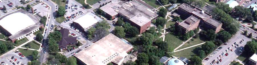
5 2009 Belknap Campus Wide Master Plan North 10 Minute Walk Radius Campus I-65 East Campus Brook St l St Hill Athletic and Recreation West Campus Cardinal Blvd 3rd St th St South Campus N Existing Buildings Future Buildings
6 Athletic Area - North of Central
 Athletic Soccer Practice Fields (2 fields)")

7 Athletic Area - North of Central Existing Municipal Park Soccer Stadium (5,000 seats) Athletic Soccer Practice Fields (2 fields) Rain Gardens Athletic Administration Building I-65 A Surface A Surface Parking Surface Parking Parking Football Stadium Major Campus Gateway
 Multiple Use Fields () Walking /")
 Storage / Restroom Building Acquire 22 acres 2 1 1 3 Retention")
8 Recreation Area - South of Central Ave Stadium Parking Major Campus Entry Central Ave Softball Field (1) Multiple Use Fields () Walking / Biking trail (.7 mile) Storage / Restroom Building Acquire 22 acres Retention Area Recreation and Special Event Parking Stadium Parking


9 Building Massing and Elevation - Looking Northwest Oval 2 2 June 10, 2009
10 Improving Pedestrian Safety along Floyd St 1. Two travel lanes and a common center turn land with bus pull offs 2. Two in road bicycle lanes one north and one south 3. Central median with a low ornamental fence. Tree planting on the median and along the street edges 5. Consolidate pedestrian crossing corridors () 6. Two traffic lights phased to allow travel speed of 25 mph City input is required to achieve these recommendations

11 Floyd St Safety Improvements Belknap Campus Master Plan The Campus Studio July 20, 2009 / August 3, Provide single north bound and single south bound travel lanes with center turn lanes at the SAC drop off and parking deck entries. A number of improvements are suggested for the Floyd St corridor which will allow it to continue as a critical campus access route while significantly improving pedestrian safety. This can be achieved by reducing community traffic volumes, slowing travel speeds, improving visibility and driver awareness, and consolidating and locating pedestrian crossing corridors in more visible areas. 6. Add north and south bound bicycle lanes contiguous to the automobile travel lanes. 7. Plant trees along both sides of Floyd St and in the median Floyd St between Cardinal Blvd and Warnock St is separated into the critical northern end (Zone A) and the southern end (Zone B). It is suggested that the following improvements be initially implemented in the north (Zone A) and ultimately added to the south (Zone B) as needed. Improve Visibility and Driver Awareness 8. Remove curbside parking 9. Relocate the bus stop and create curbside bus pull offs Discourage Community Cut Through Traffic 10. Provide a Floyd St gateway element 1. Dead end Floyd St just south of existing Bloom St on North Campus (not shown). Consolidate and Emphasize Pedestrian Crossing Points 2. Create an image of a campus drive rather than a community thoroughfare landscaped median, signage, street trees, and special site treatments. 11. Allow crossing points - Cardinal, SAC drop off, deck entry, Warnock St. 12. Place an ornamental fence down the median to restrict crossings. 3. Add pedestrian crossing platforms (speed berms) to slow traffic. 13. Use concrete pavers to delineate crosswalks. Slow Vehicular Travel Speeds 1. Add in road (embedded) flashers to alert drivers of pedestrian crossings.. Replace pedestrian platforms (if ineffective), with two additional traffic lights at pedestrian crossing points - SAC) drop off drive, and entry; phase to allow 20 miles per hour travel. Realigned walk provides direct access to deck /6 Floyd St McDonalds /6/ /13 7 5/6 9 Zone A Single south bound travel lane with a contiguous instreet bicycle path /6/8 1 3/ /6/8 1 Zone B Relocate bus stop and remove Curbside parking Belknap Deck Deck entry point 15 Floyd St Turn Lane Natatorium Student Activities Center North University of Louisville 3/13 5/ Cardinal Blvd McDonalds Playground Cardinal Park 7 The Campus Studio - Shepley Bulfinch Richardson&A - JRA Architects - ClasSickle - Staggs & Fisher Warnock St Turn Lane 1 3/ Remove Natatorium parking lot


12 Central Quad - Student Activity Area Parking Deck Places to gather, interact and do things Each quad projects its own character SAC North Quad Lawn Area South Quad


13 North Quad Connecting to SAC 1. Views to Tower 2. Diagonal walk 3. Bosque shade Tower Clock Tower SAC Brandeis North Quad Davidson

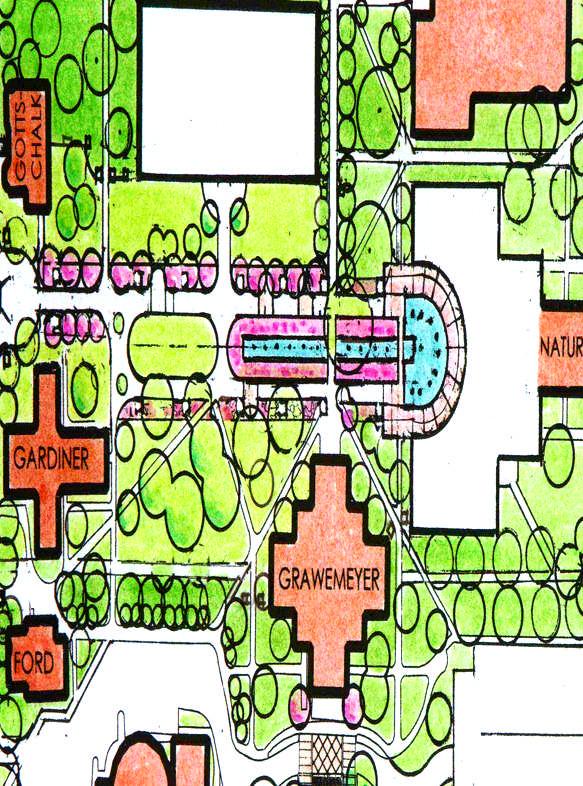
14 Fountain Plaza A Wonderful Opportunity
15 Fountain Plaza Center Place June 10, 2009


16 Library Plaza Creating place June 10, 2009


17 Fountain Plaza Library Plaza Life Sciences Special paving Column lights Wall and seating Message column Annuals and shrubs Major walk corridors Library Looking North

18 Signage and Wayfinding


19 2009 Master Plan Academic Core N Existing Buildings Future Buildings
20
Belknap Campus Master Plan Update
 Belknap Campus Master Plan Update Campus Visit 3 January 10-20, 2008 The Campus Studio Rowland Design JRA Architects Staggs & Fisher Gordon Garner Visit 3 1. A process of developing, sharing and refining
University of Louisville. Emergency Operations Plan. Annex for Campus-Wide Evacuation for. Belknap Campus
 University of Louisville Emergency Operations Plan Annex for Campus-Wide Evacuation for Belknap Campus Introduction and Assumptions During a situation where a campus emergency poses a serious threat to
Fifth and Detroit Street Design May 2017 Capital Improvements Committee. DOWNTOWN Street Design
 1 Fifth and Detroit Street Design May 2017 Capital Improvements Committee Agenda 2 Review Street Configuration Prior Meeting Review Outreach Synopsis Functional Street Design Refinements Curb Edge, Turning
WESTERN ILLINOIS UNIVERSITY
 WESTERN ILLINOIS UNIVERSITY Quad Cities Riverfront Campus Master Plan March 1, 2006 Preliminary Master Plan Total Site Build Out Western Illinois University Quad Cities Municipal Park Mississippi River
VEHICULAR AND PEDESTRIAN CIRCULATION
 This perspective sketch communicates the intended character and quality of a proposed streetscape design. Locate benches near a major intersection where people tend to gather. Seating and lighting provide
WESTERN ILLINOIS UNIVERSITY
 WESTERN ILLINOIS UNIVERSITY Quad Cities Riverfront Campus Preliminary Master Plan Presentation 2 February 1, 2006 Achieving Future Flexibility 1. Monitor space needs as the new buildings come on line and
2013 CAMPUS MASTER PLAN UPDATE
 The University of North Carolina at Greensboro 2013 CAMPUS MASTER PLAN UPDATE Board of Trustees December 6, 2013 MASTER PLAN GOALS 1. Plan for an engaging, collaborative learning environment that aligns
U n i v e r s i t y o f S o u t h C a r o l i n a A i k e n. Land Plan Study
 U n i v e r s i t y o f S o u t h a r o l i n a A i k e n Land Plan Study 06.27.2008 Goals ampus Growth Develop a Land Plan that allows for the orderly expansion of the campus over the next ten years and
Ohlone College Measure G Project Scope Revisions
 Scope Revisions Current Title Revised Title Current Scope Revised Scope 6101 Relocated Baseball Field Athletic Fields Create new sustainable baseball field with synthetic turf, bleacher seating and batting
This is the East Carolina University Comprehensive Facilities Master Plan Final Draft Plan Review. This workbook reviews the campus draft master plan
 This is the East Carolina University Comprehensive Facilities Master Plan Final Draft Plan Review. This workbook reviews the campus draft master plan first presented on campus on June 29 and June 30, 2011.
Preci nct P l ans Figure 56 Campus Aerial Photo, 2008 CAL STATE EAST BAY, HAYWARD CAMPUS MASTER PLAN
 9 Precinct Plans This section contains a detailed discussion of the planning and design concepts for specific areas or precincts of the Cal State East Bay Hayward campus. The Precinct Plans pertain to
Standards (R-3) Figure B-11: R-3 Residential Standards Exhibit
 Figure B-11: R-3 Residential Standards Exhibit") Avila Ranch Avila Ranch Specific Plan Development Standards High Medium Density - High Residential Density Residential Lot and Building Lot and Standards Building (R-3) Standards (R-3) EXAMPLES These sketches
Avila Ranch Avila Ranch Specific Plan Development Standards High Medium Density - High Residential Density Residential Lot and Building Lot and Standards Building (R-3) Standards (R-3) EXAMPLES These sketches
Subcampus Recommendations
 T he campus is is comprised of three major areas. These subcampus areas are known as WestCampus, South Campus, Campus Oakland and Drive East Campus. and Future East growth Campus. requires a Future careful
Welcome! to Keller Town Hall
 Welcome! to Keller Town Hall Keller Town Center Planning a New Downtown What is Keller Town Center? A new, growing downtown district planned as an urban village A combination of retail and office spaces,
CAMPUS MASTER PLAN DRAFT PLAN UPDATE JANUARY
 NEW MEXICO HIGHLANDS UNIVERSITY CAMPUS MASTER PLAN DRAFT PLAN UPDATE JANUARY 27 2010 MASTER PLANNING GOALS TO BALANCE THE STRATEGIC GOALS OF THE UNIVERSITY WITH THE PHYSICAL CAMPUS through the assessment
Update on University Avenue Study. September 21, 2015
 Update on University Avenue Study September 21, 2015 Existing Building Capacity Analysis Desired Potential Programs for Corridor District University Commons 50,000 +/- GSF Consolidate Student Services
The open space system should provide connective elements, relate to natural resources, and enhance the suburban character of the landscape..
 The open space system should provide connective elements, relate to natural resources, and enhance the suburban character of the landscape.. Mixed-use and infill development should maintain or enhance
Moreno Valley College: Conceptual Master Planning - Site Analysis Lasselle Street, Moreno Valley, CA 92551
 Master Plan Architect School Name Moreno Valley College District Riverside Community College District Architecture and Urban Design 5898 Blackwelder Street Ground Floor Culver City, CA 90232 T: 310.559.5720
UNCW CAMPUS MASTER PLAN
 UNCW CAMPUS MASTER PLAN JULY 27, 2017 MASTER PLAN FRAMEWORK RECOMMENDATIONS BOARD OF TRUSTEES PRESENTATION UNCW Campus Master Plan Update Board of Trustees Presentation July 27, 2017 The attached Campus
SOUTH UNIVERSITY Street Design Alternatives in Progress
 1 Alternatives in Progress 2016.01.20 Meeting Agenda 2 1. Progress & Schedule 2. Utilizing the Street Design Manual 3. Site Characteristics and Input Received 4. Street Geometry What can we accomplish
OPEN SPACE TYPES. SIZE 8 acres. SIZE 20 acres. SIZE 1 acre
 TYPICAL CHARACTERISTICS OPEN SPACE TYPES OPEN SPACE TYPES The neighborhood contains an extensive variety of open space types. Most of these spaces incorporate multiple uses and activities, so that each
NEIGHBORHOOD 7: FEE LANE AREA. Aerial View of Briscoe and McNutt Dormitories
 NEIGHBORHOOD 7: FEE LANE AREA Aerial View of Briscoe and McNutt Dormitories Fee Lane Area Map Briscoe Dormitory 278 neighborhoods NEIGHBORHOOD 7: FEE LANE AREA EXISTING CHARACTER The Fee Lane Area neighborhood
NEIGHBORHOOD 8: NORTHEAST AREA
 NEIGHBORHOOD 8: NORTHEAST AREA Carillon Tower Aerial View of Northeast Area Northeast Area Map 288 neighborhoods NEIGHBORHOOD 8: NORTHEAST AREA Campus View Apartments Student Recreational Sports Center
master plan hodge park
 KCMO Parks & Commissioners Recreation Board of Parks & Recreation Kansas City, Missouri Mark McHenry Director Heather Runkel Project Manager LAND3 Studio L.L.C. Bob G Bushyhead Principle Michael H Malyn
District Facilities Master Plan
 W o r k s h o p B o a r d District Facilities Master Plan February 29, 2012 BACKGROUND + CONTEXT ANALYSIS OPTIONS RECOMMENDATIONS NEXT STEPS DFMP AGENDA BACKGROUND + CONTEXT ANALYSIS OPTIONS RECOMMENDATIONS
CAMPUS MASTER PLAN. Steering Committee Meeting. July 29, 2014 CAMPUS MASTER PLAN UPDATE
 CAMPUS MASTER PLAN Steering Committee Meeting July 29, 2014 WORKSHOP A R C H I T E C T S, INC L H B, INC PROCESS & SCHEDULE Research Space needs data Athletics/recreational sports Previous master plan
Pedestrian and Bike Bridge LOGO
 6.2.2 Pedestrian and Bike Bridge The proposed pedestrian and bike crossing re-envisions the existing bridge at Pismo Creek on Cypress Street. The bridge is currently underutilized by vehicular through
EXISTING VEHICULAR & PEDESTRIAN CIRCULATION
 46 EXISTING CONDITIONS EXISTING VEHICULAR & PEDESTRIAN CIRCULATION Vehicular and pedestrian circulation patterns are illustrated on this graphic. Campus entry points and major vehicular circulation routes
11 February CAMPUS MASTER PLAN UPDATE Focus Group - Research Park
 11 February 2016 CAMPUS MASTER PLAN UPDATE Focus Group - Research Park AGENDA Introductions Planning Scope The 2004 Campus Plan Observations SWOT Exercise Analysis Goals and Advice Questions & Discussion
EXISTING CONDITIONS 41. Existing Conditions
 EXISTING CONDITIONS 41 Existing Conditions The Existing Analysis phase of the planning process involved a study of the existing conditions on the campus in order to identify key planning issues to be addressed
MEMORANDUM. This memo deals with proposed amendments to previously issued Development Permit No for Park Royal North.
 MEMORANDUM Date: August 28, 2015 Our File: 1010-20-15-062 To: Design Review Committee From: Lisa Berg, Senior Community Planner Re: Amendment to Development Permit for Park Royal North This memo deals
Master Plan Presentation August 12, 2015
 Master Plan Presentation August 12, 2015 A vision for tomorrow... May, 13 2015 prepared for: prepared by: SITE LOCATION SITE NTS SITE ANALYSIS +/- 17.8 Ac. RESIDENTIAL HOMES 1 2 RAIL ROAD (SAFETY CONCERNS)
FACILITIES MASTER PLAN UPDATE FINAL REFINEMENT PHASE PRESIDENT S COUNCIL PRESENTATION
 FINAL REFINEMENT PHASE 10.29.14 PRESIDENT S COUNCIL PRESENTATION 1 Process Overview 2 Campus Master Plans 3 Realizing the Vision 4 Final Thoughts Agenda Process Overview Master Planning Process Task One
CAL POLY MASTER PLAN UPDATE, March 2015
 Some Key Themes in the General Guiding Principles Academic Mission The plan must foremost advance the University s academic mission and student success. Foresight and Adaptability The plan should take
UMBC Facilities Management. UMBC Facilities Master Plan Update
 Management UMBC 2009-2019 February 19, 2010 A is the Vision for buildings, lands, open spaces and infrastructure Framework for the shape and development of the campus built environment driven by the University
GREENING THE BOULEVARD Master Plan Concepts for Venice Boulevard between Lincoln and Sawtelle
 GREENING THE BOULEVARD Katherine Spitz Associates Inc. 4212½ Glencoe Avenue Marina Del Rey, CA 90292 310 574 4460 Fax 574 4462 January 2008 Table of Contents Overview Proposed Design Improvements Illustration
Project introduction and relevance:
 Project introduction and relevance: Every city has a central area or district where, most of the social and commercial activity within the city is concentrated. Norzin Lam is in the process of becoming
theme 4 : Penn connects...
 38TH STREET STREETSCAPE WALNUT STREET STREETSCAPE GENERATIONAL BRIDGE LOCUST WALK RESTORATION SHOEMAKER GREEN 34TH STREET STREETSCAPE LOCUST WALK RESTORATION penn park SPRUCE STREET PLAZA HAMILTON WALK
4.9 Mendocino Avenue Corridor Plan Design Guidelines
 4.9 Mendocino Avenue Corridor Plan Design Guidelines The Mendocino Avenue Corridor Plan addresses the area between College Avenue and Steele Lane. Mendocino Avenue is a busy arterial that runs parallel
FROST CAMPUS MASTER PLAN SIR SANDFORD FLEMING COLLEGE
 FROST CAMPUS MASTER PLAN SIR SANDFORD FLEMING COLLEGE SEPT 2015 TABLE OF CONTENTS 1.0 Introduction 01 1.1 Master Plan Purpose 1.2 About The Campus 2.0 The Campus Master Plan 05 2.1 Vision Statement 2.2
Allegretti Architects & Andrews University
 1 Allegretti Architects & Andrews University Western Michigan University Arts Plaza Design Charrette Team Members: John W. Allegretti, FAIA Carey Carscallen, Director of Architecture, Andrews University
Public input has been an important part of the plan development process.
 Lakewood s Comprehensive Plan recognizes that transportation helps shape the community, and that the way the community provides for the safe and efficient movement of people affects the character of the
RENEWING THE MASTER PLAN
 1 RENEWING THE MASTER PLAN Harkins Hall renovation Greene Hall renovation New Classroom Building Payne Center Expansion Centennial Green improvements Quad redevelopment Front lawn improvements Southern
ROCHESTER INSTITUTE OF TECHNOLOGY Active Transportation Improvements 2010
 ROCHESTER INSTITUTE OF TECHNOLOGY Active Transportation Improvements 2010 In 2008, the Rochester Institute of Technology (RIT) completed a Comprehensive Parking and Transportation Study. Recommendations
NORTH DISTRICT. Description
 VI plan and major recommendations district plans north disrict NORTH DISTRICT Description The North District comprises approximately 105 acres and is bounded by two important bio-habitats and corridors
18 May 2016 CAMPUS MASTER PLAN UPATE
 18 May 2016 CAMPUS MASTER PLAN UPATE Council of the Deans ( Over view) AGENDA Engagement & What We Heard Focus Elements: 1. Development Framework Plan 2. Campus Mobility 3. Campus Guidelines 4. Wayfinding
Appendix 1. Private Projects with Respective On Site PUS and Public Parks in the Silver Spring CBD
 Appendix 1 Private Projects with Respective On Site PUS and Public Parks in the Silver Spring CBD Green Space Guidelines for the Silver Spring Central Business District montgomery county planning board,
Charles P. Johnson and Associates. Annapolis Landscape Architects
 Charles P. Johnson and Associates Annapolis Landscape Architects AGENDA Introduction Project Limits and Scope Site Analysis Opportunities & Constraints Program Goals Image Boards Design Alternatives Pros
Neighborhood Districts
 NEIGHBORHOOD DISTRICTS SEVEN MAIN DISTRICTS Neighborhood Districts While the Development Plan provides a broad-scale overview of the neighborhood, this section focuses on uses and relationships at the
SOUTHEAST SPORTS COMPLEX MASTER PLAN
 REPORT TO SOUTHGATE NEIGHBORHOOD COUNCIL APRIL 13, 2016 Visioning Process April 30: Stakeholder Meeting with Sports Groups May 5: Stakeholder Meeting with Southgate Land Use Committee May 13: SNC Meeting
Rolla Comprehensive Plan Update, 2005 COMMUNITY ISSUES MEMORANDUM 11/1/2004
 COMMUNITY ISSUES MEMORANDUM 11/1/2004 Introduction Throughout the planning process, but particularly during the early phases of the update, various individuals and groups will be asked to identify and
Project Goal. RRRC Living Towns Planning Workshp. Town of Halifax Revitalization Project. Dynamic Planning & Management Duo: July 12, 2006
 Project Goal Town of Halifax Revitalization Project RRRC Living Towns Planning Workshp July 12, 2006 Town of Halifax Halifax County *** Revitalization Project Goal*** To create Economic Opportunity and
lakeway mixed use tract open space plan
 LEGEND:. UNDISTURBED NATURAL AREA. ENTRY STATEMENT BUILT INTO HILLSIDE. R.O.W. PLANTING (STREET TREES/LIGHTS). HEB ENTRY DRIVE 5. BIO-FILTRATION IN MEDIAN 6. MAIN ENTRY @ MAIN STREET. EXISTING TREES TO
COMPREHENSIVE PLAN & UNIFIED DEVELOPMENT ORDINANCE
 Village of Forsyth COMPREHENSIVE PLAN & UNIFIED DEVELOPMENT ORDINANCE Community Planning #6 Prepared by: Vision Statement We envision the Forsyth Community as one which will continue to maintain a small
242 neighborhoods NEIGHBORHOOD 4: JORDAN AVENUE CORRIDOR
 NEIGHBORHOOD 4: JORDAN AVENUE CORRIDOR Aerial View of Jordan Avenue Corridor EXISTING CHARACTER The Jordan Avenue Corridor is the portion of North Jordan Avenue that extends north from East Third Street
CITY OF BOYNTON BEACH SE 1 ST STREET COMPLETE STREETS IMPROVEMENTS
 CITY OF BOYNTON BEACH SE 1 ST STREET COMPLETE STREETS IMPROVEMENTS N Project Location -Town Square -Villages at Ocean SE 1st St, between E Woolbright Rd and SE 2nd Ave Project Location -Boynton One -Publix
The principal elements of the NTC Strategic Vision plan are as follows.
 The proposed project would improve the NTC site plan, circulation, visitor amenities, and landscaping, and would include construction of two new stadiums to replace the existing Louis Armstrong Stadium
The Vision. Photo provided by The Minervini Group. 46 Vision, Objectives & Strategies
 Vision, Objectives & Strategies The is the public framework and guide for future development of the Grand Traverse Commons. The establishes public polices for infrastructure, the preservation of natural
Clairtrell Area Context Plan
 Clairtrell Area Context Plan March 2005 Urban Development Services City Planning Contents 1. Introduction... 4 2. Development Structure... 6 2.1 Streets... 7 2.1.1 Sheppard Avenue and Bayview Avenue...
campus master plan VIRGINIA STATE UNIVERSITY
 campus master plan VIRGINIA STATE UNIVERSITY agenda 01 INTRODUCTION & GENERAL OVERVIEW 02 03 04 LAND USE CONCEPT PROGRAM ACCOMMODATION MAXIMIZE EXISTING INFRASTRUCTURE SUMMARY AND NEXT 05 STEPS agenda
URBAN DESIGN BRIEF URBAN DESIGN BRIEF 721 FRANKLIN BLVD, CAMBRIDGE August 2018
 URBAN DESIGN BRIEF URBAN DESIGN BRIEF 721 FRANKLIN BLVD, CAMBRIDGE August 2018 DESIGN BRIEF CONTENTS PART A 1.0 INTRODUCTION 2.0 DESCRIPTION & ANALYSIS OF SITE CONTEXT 3.0 DESIGN CONSTRAINTS AND OPPORTUNITIES
1.0 VISION STATEMENT. December 6, PRINCIPLES
 Vision Statement Lincoln Regional Airport 1.0 VISION STATEMENT 1.1 City LOCATION of AND OVERVIEW The Easton Lincoln Place Land Use Master Plan identifies the principles, goals, policies, and standards
Long Branch-Wayne Local Park Renovation Project
 Montgomery Parks Long Branch-Wayne Local Park Renovation Project Community Meeting #2 September 20, 2016 Oak View Elementary School 7:00-9:00 PM Welcome / Team Introductions M-NCPPC (Montgomery Parks)
NORTHEAST DISTRICT. Description. Opportunities
 VI plan and major recommendations district plans northeast disrict NORTHEAST DISTRICT Description The Northeast District comprises approximately 38 acres. It is bounded by Campus Creek to the north, the
Planning Board Briefing
 Planning Board Briefing Why Now? The Sector Plan Implementation Chapter States: Before Stage 1 begins, the following must occur: Approval of the Sectional Map Amendment. Approval of the Greater Lyttonsville
ELMVALE ACRES SHOPPING CENTRE MASTER PLAN
 ELMVALE ACRES SHOPPING CENTRE MASTER PLAN Contents 1.0 INTRODUCTION... 2 2.0 LOCATION... 2 3.0 EXISTING CONTEXT... 2 4.0 VISION & GUIDING PRINCIPLES... 2 5.0 LAND USE AND BUILT FORM... 4 5.1 St. Laurent
a vibrant office and retail development enters the gateway to rutherford county
 a vibrant office and retail development enters the gateway to rutherford county PF UP Introducing Fountains at Gateway in Rutherford County Fountains at Gateway is a new 31-acre Class A multi-tenant office
BUSINESS DISTRICT DESIGN GUIDELINES
 Des Plaines, Illinois Prepared for the City of Des Plaines by: The Lakota Group Laurie Marston, AICP March 2005 Section 5: Streetscape Elements Business District Design Guidelines STREETSCAPE ELEMENTS
University of Minnesota. MINNEAPOLIS CAMPUS DEVELOPMENT FRAMEWORK February 11, 2016
 MINNEAPOLIS CAMPUS DEVELOPMENT FRAMEWORK DEVELOPMENT FRAMEWORK of use shape the campus today and may inform the future. Form, meaning how the shape, size, orientation, and arrangement of buildings, spaces,
R STREET CORRIDOR NEIGHBORHOOD Site Plan and Design Review Supplemental Guidelines Checklist
 R STREET CORRIDOR NEIGHBORHOOD Site Plan and Design Review Supplemental Guidelines Checklist Applicant s Name: Project Address: Phone: Email: Applicant shall fill out the design guidelines checklist for
Illustrative Campus Plan with Proposed Development
 Illustrative Campus Plan with Proposed Development Approved Compiled Plan January 2003 Figure IV-52 89 The supportive relationship and interaction between the campus and the surrounding community is an
CHARLOTTESVILLE. Streetscape ENTRANCE CORRIDOR DESIGN GUIDELINES. Amendments adopted by City Council March 7, Design Principles...
 CHARLOTTESVILLE ENTRANCE CORRIDOR DESIGN GUIDELINES Amendments adopted by City Council March 7, 2011 2 Streetscape A. B. C. D. E. F. G. H. I. Design Principles...5 Plantings & Open Space...6 Pedestrian
PLANNING RATIONALE FOR THE PROPOSED RIVERSIDE SOUTH ELEMENTARY SCHOOL 715 BRIAN GOOD AVENUE, OTTAWA, ON
 PLANNING RATIONALE FOR THE PROPOSED RIVERSIDE SOUTH ELEMENTARY SCHOOL 715 BRIAN GOOD AVENUE, OTTAWA, ON Conseil des écoles publiques de l'est de l'ontario (CEPEO) French Public School Board TABLE OF CONTENTS
Boise State University October 8 - Workshop # 2. MASTER PLAN UPDATE Executive Committee Ayers Saint Gross
 Boise State University October 8 - Workshop # 2 MASTER PLAN UPDATE Executive Committee Ayers Saint Gross WORKSHOP AGENDA 01 WORK SESSION SUMMARY Program clarifications res life, trans, STEM Concept Plan
Adoption of the Rosslyn Sector Plan Site Plan Review Committee (SPRC) Meeting October 26, 2015
 Meeting October 26, 2015") Adoption of the Rosslyn Sector Plan Site Plan Review Committee (SPRC) Meeting October 26, 2015 Rosslyn Sector Plan Introduction Adopted by the County Board in July 2015 Reflects the new long range planning
Adoption of the Rosslyn Sector Plan Site Plan Review Committee (SPRC) Meeting October 26, 2015 Rosslyn Sector Plan Introduction Adopted by the County Board in July 2015 Reflects the new long range planning
urban design Introduction
 ACHIEVE SP RI NGF I ELD.3 Introduction Urban Design Areas Design Areas are areas within Springfield that have a unique and recognizable character that is different from other areas in the community. The
BRADENTON RIVERWALK EXPANSION MASTER PLAN
 BRADENTON RIVERWALK EXPANSION MASTER PLAN INTRODUCTION & AGENDA Process Update Community Engagement Summary Center for Active Design (CfAD) Recommendations Context and Existing Conditions Master Plan Alternatives
Part C. Main Campus Plan Frameworks PAGE 59 UNIVERSITY OF REGINA / CAMPUS MASTER PLAN 2011
 Part C Main Campus Plan Frameworks UNIVERSITY OF REGINA / CAMPUS MASTER PLAN 2011 PAGE 59 Figure C-1. Open Space Framework Plan PAGE 60 PREPARED BY / DIALOG Figure C-2. The Dr. Lloyd Barber Academic Green
A larger version of this map is located on the last page of this PDF.
 MAP Committee Input McLoughlin Area Draft Vision Map A larger version of this map is located on the last page of this PDF. 1. The map above is intended to portray a vision for the McLoughlin area. It highlights
C a m p u s I d e n t i t y
 Campus Identity Campus Identity a) Landscape Guidelines i. Materials ii. Components iii. Composition b) Wayfinding i) Entrance Features ii) Vehicular iii) Pedestrian c) Focus Areas i) Green Spine ii) Warriner
KASPER. City of Georgetown, Texas PUD Planned Unit Development. December 30, 2015 Revised January 27, 2016
 KASPER City of Georgetown, Texas PUD Planned Unit Development December 30, 2015 Revised January 27, 2016 Applicant: Sentinel Land Company, LLC 4910 Campus Drive Newport Beach, CA Prepared by: SEC Planning
Jack L. Robbins, AIA Principal
 DesignING FOR HEALTH Jack L. Robbins, AIA Principal We shape our buildings, and afterwards our buildings shape us. - Winston Churchill, 1943 Design ---> HEALTH Design can change behavior. Changed behavior
Access Management: An Overview
 Figures 1-5 Below Evolution of development along a highway. In the early stages, land along the road is used for farming with little traffic generated. As time passes, the highway corridor becomes a de
C AMPUS MASTER PLAN THE C AMPUS PLAN
 THE CAMPUS PLAN. the campus plan The Middlebury Campus Master Plan is intended as a framework within which carefully balanced, incremental decisions may be judiciously made within a long-term vision. It
The Capital Design Advisory Committee St. Mary s College of Maryland & Historic St. Mary s City
 The Capital Design Advisory Committee St. Mary s College of Maryland & Historic St. Mary s City Welcome April 21, 2010 Capital Design Advisory Presentation: Relocating Margaret Brent Hall Traffic Calming
COMPLETE GREEN STREET CHECKLIST
 COMPLETE GREEN STREET CHECKLIST This document was developed to dissect the structure of an urban street and explore opportunities to make our streets more complete while also integrating green street strategies.
PUBLIC RIGHT-OF-WAY IN THIS CHAPTER PUBLIC REALM
 PUBLIC RIGHT-OF-WAY This section provides design guidelines for improvements in the public right-of-way. The public right-of-way refers to streets, sidewalks, non-vehicular thoroughfares, parks and greenways
Design Guidelines for the Route 30 Corridor Master Plan: Subdivision and Land Development Elements
 Design Guidelines for the Route 30 Corridor Master Plan: Subdivision and Land Development Elements East Whiteland Township- Chester County, PA Prepared by: Draft: May 7, 2018 Design Guidelines for the
4-Town Comprehensive Plan DRAFT 7/30/07
 4-Town Comprehensive Plan DRAFT 7/30/07 Acknowledgements ning Committee Town of Harrisburg Norman Roof Randy Nicol Town of Martinsburg Terry Thisse Paul Kelly Town of Montague Jan Bagdanowicz Wendy Perry
SFMTA PHELAN LOOP AND PUBLIC PLAZA PHELAN OCEAN AVENUE
 SFMTA Municipal Transportation Agency Image: a bus in front of the Palace of the Legion of honor SFMTA PHELAN LOOP AND PUBLIC PLAZA PHELAN AVENUE @ OCEAN AVENUE Community Meeting May 23, 2012 San Francisco,
URBAN DESIGN BRIEF 305, 309, & 315 SOUTHDALE ROAD WEST LONDON ONTARIO
 URBAN DESIGN BRIEF 305, 309, & 315 SOUTHDALE ROAD WEST LONDON ONTARIO CARVEST PROPERTIES LTD. December 2013 Section 1 - Land Use Planning Context 1.1 Subject Lands The subject lands are located immediately
Urban Design Webpage-Definitions
 Urban Design Webpage-Definitions What is Urban Design? Urban Design addresses the character and quality of the built environment in relation to the human scale. Urban designers are involved with building
REPORT TO BOARD ON PREFERENCES tbp/architecture CCSF Facilities Master Plan, October 23, 2016
 PURPOSE The purpose of this report is to update the Board on the Facilities Master Plan initiative. PROCESS The Board conducted a Study Session about Phase 1 Needs on August 18, 2016. Since that time,
R.O.M. = Rough Order of Magnitude
 3. SITE DEVELOPMENT GENERAL LOCATION The City of Corpus Christi is located on Texas coast of the Gulf of Mexico about a third of the way from the Mexican border to the Louisiana border. It is on the west
The University District envisions, in its neighborhood
 Envisioning the University District Link Light Rail in Seattle s neighborhoods CIY OF SEALE CONCEP-LEVEL SAION AREA PLANNING RECOMMENDAION RESOLUION # 30165 EXHIBI L Vision 08.2000 he University District
Improve Neighborhood Design and Reduce Non Point Source Water Pollution
 HOW TO Planning Guide Improve Neighborhood Design and Reduce Non Point Source Water Pollution This document was funded by a grant from the New Hampshire Coastal Program with funding from the National Oceanic
AUSTIN MEDICAL DISTRICT MASTER PLAN"
 AUSTIN MEDICAL DISTRICT MASTER PLAN"!"#$%&'"()(&$*+,--$ ,$?+,'=2,)0$!)=@,+'=03$AB,+-(C)'$ DE,$!)=@,+'=03$C/$D,F-'$-0$%&'()$ $?-),H='0'P$.(/$0&1"23$ $ G,)=C+$,$?+,'=2,)0$ G,0C)$
Sub Area 2: Downtown Overland Park
 Downtown 132 2.12 encompasses over 600 acres and extends between 71st Street and 87 th Street including Downtown Overland Park. The area is home to several individual historic sites and structures, including
11.0 TRANSPORTATION ELEMENT
 11.0 TRANSPORTATION ELEMENT Transit, Circulation and Parking Sub-Element: For all campuses, FIU's goal is to increase multimodal access. In combination with other measures - such as the development of
400 West Georgia Street Urban Design Panel. Public Realm
 400 West Georgia Street Urban Design Panel Public Realm Public Benefits The main benefit in regards to the proposed development at 400 West Georgia Street will be to increase density of Commercial Office