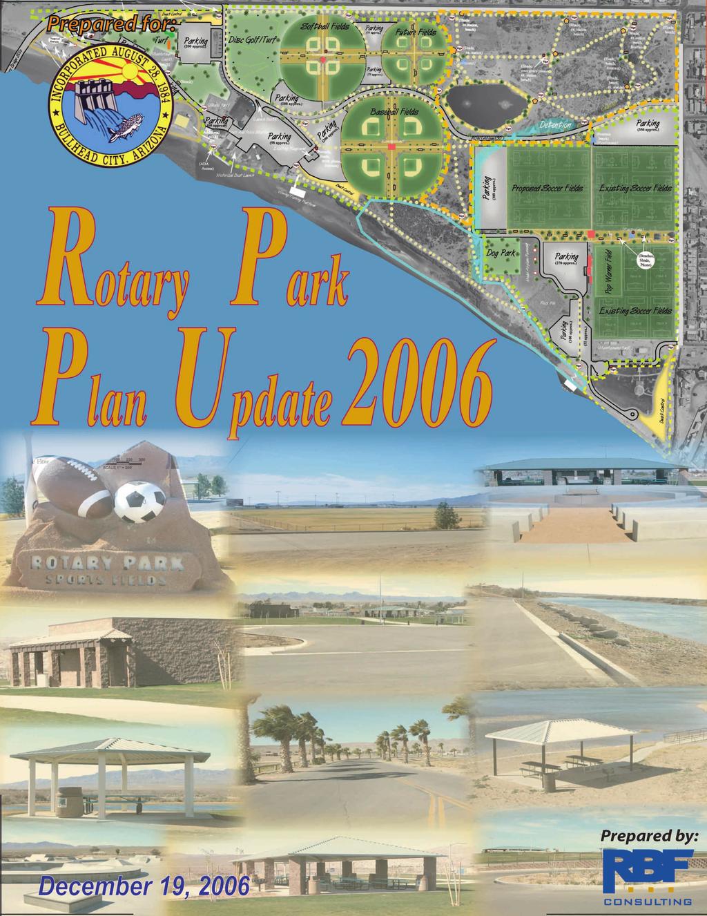
Bullhead City Rotary Park Plan Update
|
|
|
- Aron Ellis
- 5 years ago
- Views:
Transcription
1


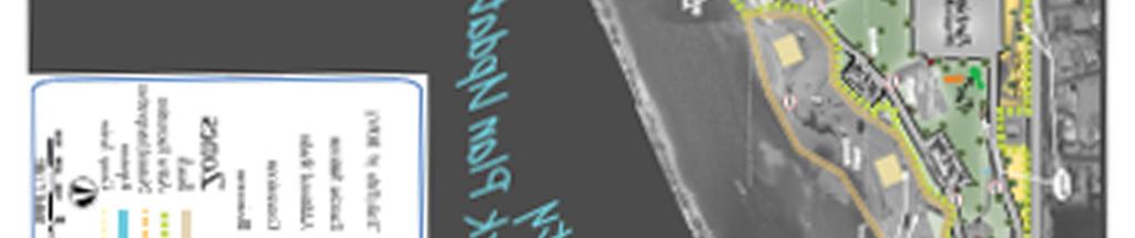
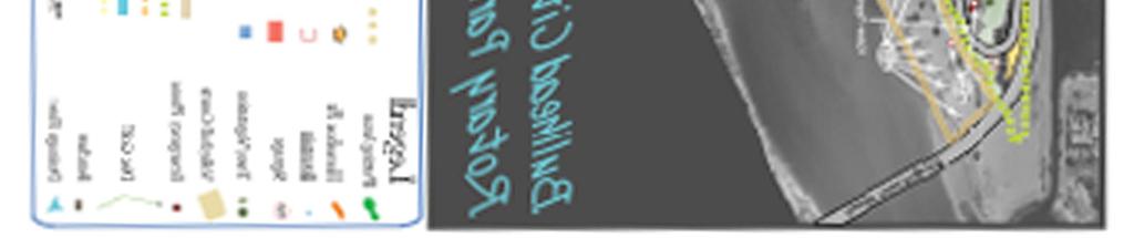
2 Bullhead City Rotary Park Plan Update PLANNERS/LANDSCAPE ARCHITECTS: RBF Consulting N 28 th Avenue Suite 100 Phoenix, Arizona (602) CIVIL ENGINEER: RBF Consulting N. 28 th Avenue Suite 100 Phoenix, Arizona (602)
3 The Project...4 Background and Purpose...4 Planning Process Overview...4 Inventory and Analysis...5 Data Collection...5 Grant Improvements Implemented Since Reclaimed Water Irrigation...5 Land Analysis...6 Existing Elements...6 Public and Stakeholder Involvement...7 Staff Workshop...7 Public Meetings...7 Review Agency Session Vision and Goals Summary Vision and Program Elements from July 12 Public Meeting Programming Element Priorities Plan Update Conceptual Plan Breakdown Conceptual Plan Update Exhibit Program Elements to be Implemented after Costs Budget Sheet Section Trails Exhibit Main Boulevard Exhibit... 18
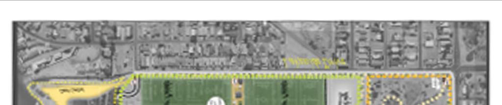
4 The Project Background and Purpose The City of Bullhead City has a unique identity in that it shares various cultural, historic, and recreational opportunities. Residents include those who have been there for many generations, along with an influx of new residents from across the country and globally. Historic mining and river operations originally attracted residents to this region, and mostly today the area harbors casino and tourist attractions that are all based around the Colorado River. What s most important in the City of Bullhead City are the residents, and they should have ample opportunities to enjoy the Colorado River in an area where high temperatures are frequent throughout the year. Rotary Park is a Gateway to the Colorado River, and shall be appropriately designed to allow for easy and safe access. Rotary Park will also contain various program elements to fit the recreation needs of the city, which will include active and passive play activities. The City of Bullhead City, Arizona has undergone rapid transformation and growth since the last revision of the Rotary Park plan in The City is undergoing population increase, and the pressure on the recreation system is reported to be intense. Construction has been implemented based on the various program elements discussed in the 2000 plan, but there is still need to carry on with these improvements, or to make alterations to the plan based on residents and city staff opinions as of Rotary Park is approximately 212 acres and is bounded on the north by Riverview Drive, on the east by Lakeside Drive, and on the south by the Colorado River. It is leased by the City from the Bureau of Land Management, and is identified in the 1991 General Plan Update as a regional park serving the City of Bullhead City. Program elements built and improved upon since 2000 include; beach improvements and access, the riverfront trail, skate park, basketball courts, ramada/picnic areas, 4 softball fields with concessions, soccer field improvements, multiple restrooms, landscaping, parking facility improvements, several playgrounds, and group camping with a non-motorized boat launch at the south end of the park. Lastly, the Section 10 wastewater treatment plant is currently generating water to be used for irrigation of this park from an existing effluent pond. The purpose of the Conceptual Plan Update is to design a flexible planning tool for the City staff to initiate funding and design of proposed improvements, to integrate the existing facilities, and to balance the needs of recreation and open space users with the community that exists adjacent to the park. Planning Process Overview The City engaged the firm of RBF Consulting in analyzing the site in terms of existing conditions, performing inventory analysis of program elements, analyzing drainage and traffic patterns for opportunities and constraints, engaging the general public, city staff, and stakeholders 4 Bullhead City Rotary Park Concept Plan 12/19/06
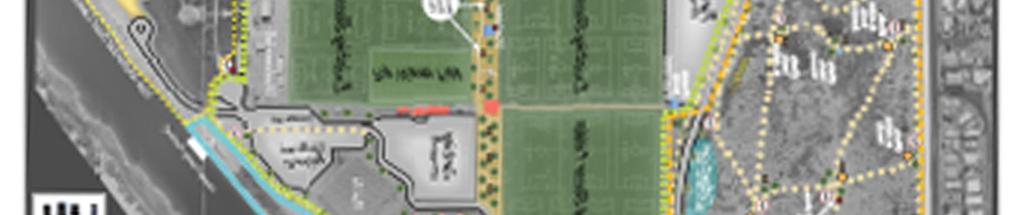
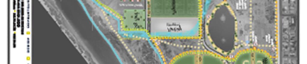
5 in the planning process, and recording the results of the process for future use. This document represents a summary of this effort. Inventory and Analysis Data Collection A conceptual plan for the site had been completed previously by City Staff, and approved by the Parks and Recreation Commission and City Council. The major objection to this original plan was too much roadway and parking along the river. This resulted in the creation of the 2000 Bullhead City Rotary Park Concept Plan. This plan gathered city staff and public input to improve and make additions to Rotary Park with the inclusion of various program elements. The previous 2000 Rotary Park Master Plan served as a base in updating the plan for Site plans, survey drawings provided by the city, site surveys, aerial/topographic data acquired by the consultant, drainage data/reports, discussions with City staff and the public, all resulted in adequate data for making the plan update. Grant Improvements Implemented Since 2000 The State Lake Improvement Grant enabled the City to improve the beach area by providing construction of restrooms, sidewalks, ramadas, ADA access, landscaping, paved/lighted parking adjacent to Balboa Rd, pathway lighting, and trash receptacles. Other grants have enabled construction of the basketball courts, softball fields, soccer fields, first aid station, boat ramp, dock, and their associative parking. The KaBOOM playground is found in the north beach area that features various swing and jungle gym equipment. Lastly, the skate park and expansion of the Colorado River Heritage Greenway Trail has also been implemented since In 2005 the city constructed a non-motorized boat launch, group campground, and amenities at the southeast corner of the park assisted by SLIF funds. Lighting for all soccer fields, improvements to playgrounds, grass and landscaping on the north beach, benches, ramadas, and a drinking fountain have been funded for 2006 and 2007 with assistance of grant funding. Reclaimed Water Irrigation An irrigation system as been placed throughout the park site with reclaimed water lines dispersed centrally from the located effluent pond. The effluent lines have been placed throughout the park, but the lines are rarely used. These lines should be utilized to minimize potable water use, and can be used to irrigate anticipated turf areas that are in conjunction or adjacent to the 5 Bullhead City Rotary Park Concept Plan 12/19/06
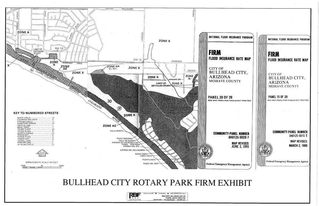
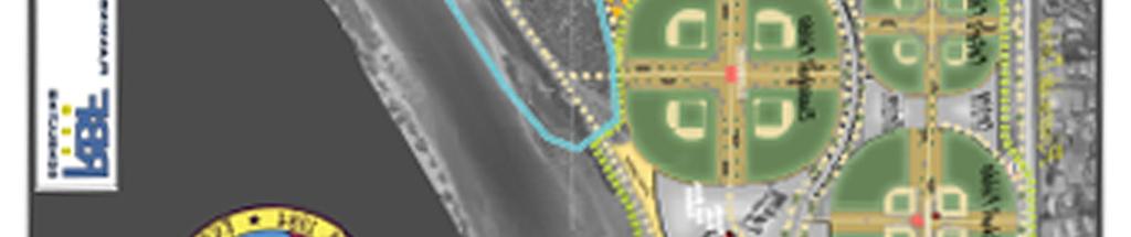
6 reclaimed water lines. The softball fields to the north, proposed baseball fields to the south, dog park, and the proposed soccer field to the west are in proximity of the reclaimed water lines (See conceptual plan update exhibit for proposed uses). Appropriate signage will be placed giving warning of the risks of reclaimed water and that users should use certain precaution when in these areas. Land Analysis A jurisdictional wash delineated by the Corps of Engineers in 1998 exists in the northeastern portion of the park. It flows for about 1500 feet into the site. Proposed program elements are designed to not encroach into the delineated area. The Corps of Engineers has advised the City that proposed uses could be allowed via approval of the applicable Nationwide Permit (NWP) as long as the area of impact is no more than.5 acres. Drainage for the most part is into a depression at the center of the site. At this point, floodwater becomes sheet flow and currently flows across the existing southern soccer fields to a drainage channel at the southeast corner of the site. A drainage analysis has been performed to reroute flows from the center of the site directly south to the Colorado River through a 80 wide channel with slopes to 8:1. This will proceed from the end of the delineated wash; will flow through a weir structure over the park boulevard road into the parking lot west of the soccer fields, and will continue to flow directly south to the Colorado River (see conceptual plan update exhibit and appendix A). An existing effluent pond and a pump station structure exists and will remain on site. The pond is raised aboveground seven feet to stay out of the floodplain. This may cause some access difficulties, and trails would have to be appropriately designed. The area around the pond allows for improvement to make the area a more pleasing environment for trail users. Existing Elements A lift station exists and will remain at the southern end of the soccer fields. A well is also near this facility. A fiber-optic cable runs east/west starting at the Lakeside Dr/Riverview intersection and travels almost parallel to Riverview Dr. to the river. A marina and motorized boat launch exists associated with several other structures. This includes an entry drive with pay station, first aid station, a substantial paved and lighted parking lot (approximately 80 total spaces), small areas with picnic tables, gazebo, and ramadas. Improved access to these areas is shown in the conceptual plan update. Basketball courts exist between the front entry parking and the beach. 6 Bullhead City Rotary Park Concept Plan 12/19/06
7 Four softball fields have been recently constructed on the north end of the park with accommodating facilities, restrooms, and concessions. Eight soccer fields exist at the eastern edge of the site along Lakeside Drive. An access road enters the park from Lakeside Drive and follows the perimeter of the soccer fields to the group camping area at the southeastern end of the park. The fields are partially lighted and are irrigated using potable water. A model airplane paved runway is west of the soccer fields and has adjacent parking. A large stockpile of rock exists near the model airplane runway and belongs to the Bureau of Reclamation. This will remain at the current location in Rotary Park to receive future Title 28 grants from the Bureau of Reclamation through BLM. These grants are used to provide funds for park improvements, and it is recommended to leave the Reclamation stockpile on site to receive future grants. The stockpile is primarily for the protection of bank lines to the Colorado River during flood emergencies, and could possibly be relocated within the park to create additional park space and to address safety concerns near parking. Aesthetic treatment will be proposed around the stockpile to improve parking areas, and signs can also be placed warning park users to avoid climbing in the area. ADA compatible access to the river occurs in two locations north of the boat launch and near the beach. There are no sidewalks along Riverview Drive or Lakeside Drive. Having sidewalks along the north side of the park and the east side would establish a definite border around the park. Public and Stakeholder Involvement Staff Workshop A staff workshop was held with the Technical Advisory Committee after the public meeting on July 12, Program elements from the public meeting were discussed and emphasis was placed on certain issues in the park regarding shade, landscaping, roads in the park, access to the beach, and establishing an event area in the Northwestern Area of the park site. Public Meetings Public input meetings were held on July 12 and September 26 for the Rotary Park Concept Plan Update. The July 12 meeting was to consider if the program elements mentioned in the 2000 plan were still applicable to the updated plan. Results from the July 12 meeting concluded to continue with some of the program elements in the 2000 plan and to discontinue 7 Bullhead City Rotary Park Concept Plan 12/19/06
8 others based on needs assessments from those in the public and the city staff. (See 2006 vision and program elements from July 12 th public meeting). The objective of the September 26 th public meeting was to show the plan update based on the first meeting held in July. Results from the September meeting concluded in re-configuring the internal circulation system, moving the proposed soccer field adjacent to the existing field, switching the location of the dog park to the southeast portion of the park, providing additional ramp/ada access to the cove north of the marina, placing emphasis on the actual trail design, creating a boulevard concept with the main road network that bisects the park, and adding sidewalk/vegetation improvements along Lakeside and Riverview Drive. Review Agency Session Members of the reviewing agencies (Parks & Recreation Commission & Council) were present at the July 12 th and September 27 th public meetings, and gave their input on existing elements in the park, and what they would like to see built after The reviewing agencies will provide additional input at the next reviewing agency sessions held on December 7th, and December 19th. The Parks and Recreation Commission hearing had minimal comments in regards to the version of the Rotary Park Plan on November 15 th. Questions were asked from members of the Parks and Recreation Commission in regards to the placement of the proposed concession building between the proposed soccer field and the existing soccer field, and adequate parking supply. The consultant and city planner addressed these questions, and Parks and Recreation members came to agreement with the current plan Vision and Goals Summary Vision Statement: The City of Bullhead City envisions a land-and water-based park serving a variety of regional users that includes a balance of active sports, passive recreation, and natural areas supported by complementary infrastructure. 8 Bullhead City Rotary Park Concept Plan 12/19/06
9 2006 Vision and Program Elements from July 12 Public Meeting 9 Bullhead City Rotary Park Concept Plan 12/19/06
10 2006 Programming Element Priorities Active Recreation Priorities Tentative Construction Dates 1) Additional soccer field. (lighting, fencing, Mid 2008 benches, shade, outside field improvements, dust control, parking, and restroom/concession building). 2) South baseball fields (lighting, fencing, Late benches, shade, outside field improvements, dust control, parking, and restroom/concession buildings). 3) Additional Volleyball Courts Late ) Dog Park Late ) Future Fields 2010 Passive Recreation Priorities Tentative Construction Dates 1) Internal trail network within the Early 2010 Natural/Interpretive Zone (Designated Paths, decomposed granite around effluent pond, shade/vegetation approximate to existing effluent lines, signage program, exercise stations, and benches). 2) Viewing/Fishing Platforms Late ) Disc Golf Early ) Practice Putting Area Mid ) Horseshoe Court Mid 2008 Other Priorities Tentative Construction Dates 1) Additional road access at Chaparral Drive. Mid ) North beach loop and associative parking ) Balboa Road extension with trees, 2009 vegetation, and trails/sidewalks. 4) Perimeter curbs, gutter, and sidewalks on 2012 Lakeside and Riverview Drives. 5) Trees and vegetation along Riverside and 2009 Lakeside Drives. 6) Safety signs, emergency phone boxes Mid Late Bullhead City Rotary Park Concept Plan 12/19/06
11 7) Dust Control On going 8) Shade and benches approximate to parking On going 9) Water Fountains On going 10) Colorado River Bridge designation and Future final design 2006 Plan Update Conceptual Plan Breakdown Activity zones are identified on the Conceptual Plan (see conceptual plan update exhibit). There are five zones that include the Beach, Active Recreation, Natural/Interpretive, Riparian, and Group Active. Beach Zone: The beach zone shall include a mix of passive and active play activities. There are numerous shade structures that allow for picnicking and retreat from the sun. The area provides for beach sort of play that is family oriented, and shall be patrolled and secured to deter any violent, vandalistic activities. Active play areas in the beach zone include the sand volleyball courts, playground equipment, swimming, and water sports. Active Recreation Zones: These zones provide for active recreational activities that are to have intense uses associated with organized sports, and have open turf areas for informal play. These active areas include sports sessions associated with softball, baseball, soccer, dog parks, basketball courts, skate park, marina & boat launch, and the model airplane runway. The Active Play area consists of mown turf area in the sports fields and informal play areas. Turfed areas may be irrigated using potable or reclaimed water irrigation lines, and turfed areas under reclaimed irrigation should be posted for recreational users. Natural/Interpretive: The Natural/Interpretive area consists of the Jurisdictional Wash, the area around the effluent pond, and the natural terrain that transverses to the southwest between the baseball and soccer complexes. It is intended that the natural area be planted with native species, which may include wildflowers and grasses that can be irrigated with the effluent lines. It will provide an alternative to the turf areas of the Active Recreational Zones, and will provide for passive activities that will include trail and mountain bike use, exercise stations, and signage to give appropriate direction throughout the park. Riparian: This zone primarily follows the Colorado River and users can enjoy this area by using the River View Trail. This zone allows for passive type activities and exceptional views of the 11 Bullhead City Rotary Park Concept Plan 12/19/06
12 river. This trail will also provide access to the viewing/fishing platforms, and connection to the Natural/Interpretive zone and Heritage Trails. Group Active: This zone is primarily at the southeastern end of the park and allows for group activities associated with the amphitheatre in the group camping area. The non-motorized boat launch is also in this zone that allows use for kayak and canoe type users. 12 Bullhead City Rotary Park Concept Plan 12/19/06
13
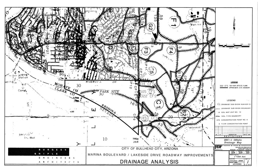
14 BULLHEAD CITY ROTARY PARK CONCEPTUAL DRAINAGE REPORT 1/3/2007 Exhibit 2, HEC-1 Offsite Drainage Map JN: APPENDIX
15
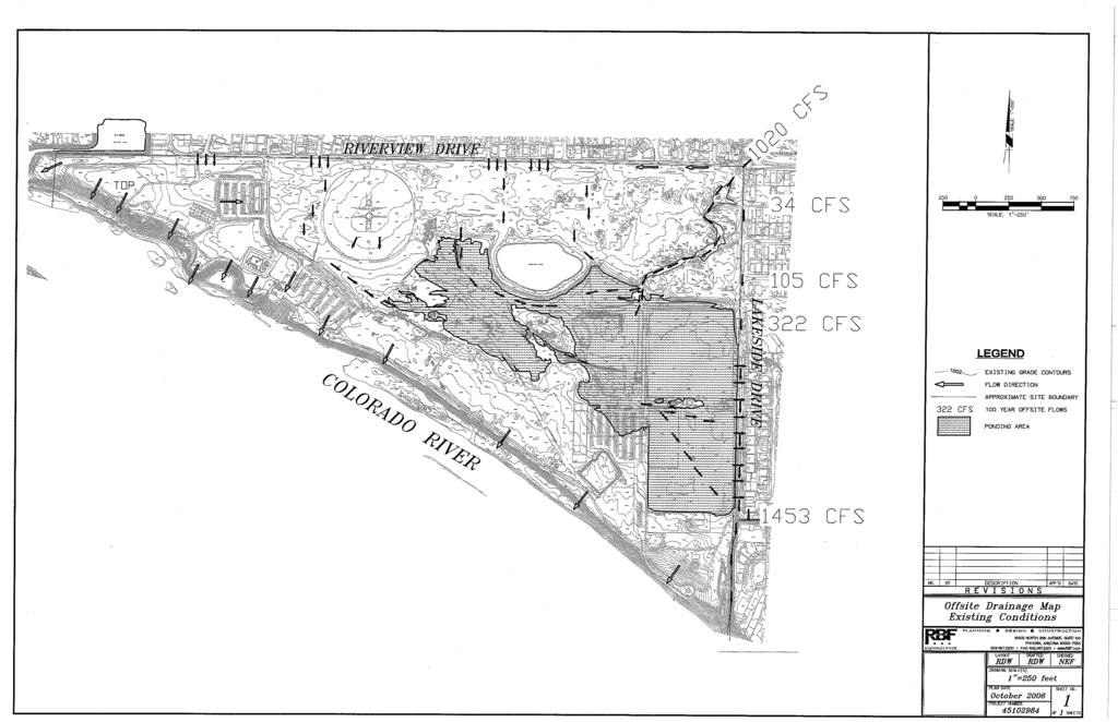
16 BULLHEAD CITY ROTARY PARK CONCEPTUAL DRAINAGE REPORT 1/3/2007 Exhibit 3, Offsite Drainage Map (Existing Conditions) JN: APPENDIX
17
18 BULLHEAD CITY ROTARY PARK CONCEPTUAL DRAINAGE REPORT 1/3/2007 Exhibit 4, Offsite Drainage Map (Proposed Conditions) JN: APPENDIX

19
20 BULLHEAD CITY ROTARY PARK CONCEPTUAL DRAINAGE REPORT 1/3/2007 Exhibit 5, FlowMaster Output JN: APPENDIX
21
22
23
Las Colonias Park Master Plan
 2013 Las Colonias Park Master Plan City of Grand Junction June 2013 Introduction Las Colonias Park, a 101 acre parcel on the edge of the Colorado River south of downtown, was deeded to the City of Grand
PARTF Scoring System for Grants
 PARTF Scoring System for Grants The members of the N.C. Parks and Recreation Authority use the PARTF scoring system as one of several tools to select grant recipients. Please provide all of the information
Y Sports Complex PROGRAMMING Capitol Improvement Plan. Anticipated/Suggested Improvements. Sedgwick County Park: Sports Complex:
 PROJECT OVERVIEW Location: East of Ridge Road, between 21 st Street and 13 th Street, not including SCZ In conjunction with The Sedgwick County Park Facilities Observation Report Compilation of improvements
1. Parks & Recreation Neighborhood Parks Community Parks Special Use Sites 2. Open Space 3. Trails
 Appendix A: Park Classifications The intent of parks and recreation classifications is to aid in making acquisition and design decisions for park sites, facilities and the organization of recreation space
Park Types and Attributes
 02 APPENDIX B APPENDIX B s and s 194 APPENDIX B 04 Size Level of Service Any privately owned park, of any size, is a neighborhood park Primary Service Area - 1/2 mile or within 15 minutes walking distance
City of Bonney Lake Allan Yorke Park. MASTER PLAN SUMMARY REPORT June 30, 2016
 City of Bonney Lake Allan Yorke Park MASTER PLAN SUMMARY REPORT June 30, 2016 TABLE OF CONTENTS INTRODUCTION PUBLIC INVOLVEMENT PROCESS MASTER PLAN North Park Central Park South Park East Park Field Development
Appendix E Section 4(f) Evaluation
 Evaluation") Appendix E Section 4(f) Evaluation Appendix E Draft Section 4(f) Evaluation E.1 Introduction This appendix addresses a federal regulation known as Section 4(f), which protects parks, recreation areas,
Appendix E Section 4(f) Evaluation Appendix E Draft Section 4(f) Evaluation E.1 Introduction This appendix addresses a federal regulation known as Section 4(f), which protects parks, recreation areas,
SOUTHEAST SPORTS COMPLEX MASTER PLAN
 REPORT TO SOUTHGATE NEIGHBORHOOD COUNCIL APRIL 13, 2016 Visioning Process April 30: Stakeholder Meeting with Sports Groups May 5: Stakeholder Meeting with Southgate Land Use Committee May 13: SNC Meeting
South East Sports Complex Phase I
 South East Sports Complex Phase I City of Spokane Design Review Board August 29, 2018 (Revised) Objectives 1. Early discussion and collaboration. 2. Provide framework / catalyst for future improvements
Long Branch-Wayne Local Park Renovation Project
 Montgomery Parks Long Branch-Wayne Local Park Renovation Project Community Meeting #2 September 20, 2016 Oak View Elementary School 7:00-9:00 PM Welcome / Team Introductions M-NCPPC (Montgomery Parks)
City Council March 27, Parks, Recreation, and Trails Master Plan
 City Council March 27, 2018 Parks, Recreation, and Trails Master Plan Planning Process Develop Goals and Objectives Inventory of Areas and Facilities Needs Assessment And Identification Public Participation
City of Naples Parks Master Plan (Draft)
") City of Naples (Draft) CSAB April 12, 2016 OVERVIEW Presentation Outline Overview Needs Assessment Recap Response to Needs Implementation Strategy Questions, Discussion Preserving Naples: A vision plan
City of Naples (Draft) CSAB April 12, 2016 OVERVIEW Presentation Outline Overview Needs Assessment Recap Response to Needs Implementation Strategy Questions, Discussion Preserving Naples: A vision plan
Minto-Brown Island. November 18, City of Salem, Parks & Transportation Services
 Minto-Brown Island Park Master Plan Public Meeting #1 November 18, 2014 City of Salem, Parks & Transportation Services Division, i i Public Works Welcome... and thanks for participating in the master planning
Outdoor Recreation Facilities Inventory
 Outdoor Recreation Facilities Inventory Allouez Neighborhood Parks: East Lawn Park (4.90 acres) is located in the northeastern corner of Allouez near Boyd Street. This site contains: Baseball diamond with
Appendix A. Park Land Definitions
 Appendix A Park Land Definitions Mini Park May serve specific function for any and all ages, depending on need of the user area. Size range 1-5 acres with optimum size being 3 acres. Service area is sub-neighborhood
(Exhibit A) Site Plan Adoption Detail and Support Information
 Site Plan Adoption Detail and Support Information") McCormick Park Master Site Plan (Exhibit A) Site Plan Adoption Detail and Support Information July, 2003 McCormick Park Site Plans.... 2-3 McCormick Park Site Plan Comparison... 4 Basic Assumptions about
McCormick Park Master Site Plan (Exhibit A) Site Plan Adoption Detail and Support Information July, 2003 McCormick Park Site Plans.... 2-3 McCormick Park Site Plan Comparison... 4 Basic Assumptions about
Charles P. Johnson and Associates. Annapolis Landscape Architects
 Charles P. Johnson and Associates Annapolis Landscape Architects AGENDA Introduction Project Limits and Scope Site Analysis Opportunities & Constraints Program Goals Image Boards Design Alternatives Pros
3. VISION AND GOALS. Vision Statement. Goals, Objectives and Policies
 Vision Statement Queen Creek s interconnected network of parks, trails, open spaces and recreation opportunities provide safe and diverse activities and programs that sustain its unique, small town, equestrian
City of Los Angeles Department of Public Works
 City of Los Angeles Department of Public Works Environmental Scoping Meeting for the Proposed Sixth Street Park, Arts, River & Connectivity Improvements (PARC) Project May 3, 2017 1 Agenda Introductions
Southeast Quadrant Plan
 Southeast Quadrant Plan Southeast Quadrant Distinctive Features Land Use The Southeast Quadrant includes all the area within the planning area that is east of Interstate 5 and south of State Route 44.
Chapter 5: Recreation
 Chapter 5: Recreation Introduction and Setting Recreational opportunities within Nevada County are varied, ranging from public parks with intensively used active recreational facilities, to vast tracts
29 Bella Fontaine Park
 29 Bella Fontaine Park 9565 Bellefontaine Road St. Louis County Parks Master Plan Planning Zone 2 Visit Date: July 2016 Page 1 129 Bella Fontaine Park 9565 Bellefontaine Road St. Louis County Parks Master
PARKS. Chapter Introduction
 Chapter 4. PARKS 4.1. Introduction This Parks Element of the 2016 Comprehensive Plan Update provides direction and guidance, based on citizen input, in order to improve and maintain the City s existing
Draft Master Plan for Franklin Park
 Draft Master Plan for Franklin Park Metro Parks Tacoma with SiteWorkshop November 2009 I. overview & background Process & History Master Plan Process The Master Plan is based on a community involvement
A 2012 Clean and Safe Neighborhood Parks Bond Project. Katy Tang, District Supervisor. Jasmine Kaw, Landscape Architect Will Kwan, Architect
 West Sunset Park A 2012 Clean and Safe Neighborhood Parks Bond Project Community Meeting #2 November 20, 2013 Katy Tang, District Supervisor Dan Mauer, Project Manager Jasmine Kaw, Landscape Architect
Martin Pastucha, Director of Public Works Karen Ginsberg, Director of Community and Cultural Services
 Information Item Date: August 11, 2015 To: From: Subject: Mayor and City Council Martin Pastucha, Director of Public Works Karen Ginsberg, Director of Community and Cultural Services Reed Park Improvement
Emerson Park Master Plan Update. Public Meeting III August 27, 2014
 Emerson Park Master Plan Update Public Meeting III August 27, 2014 Meeting Agenda: Project Update Presentation of Master Plan Components Discussion and Feedback The Path Forward: Building on the Concept
MADISON MANOR PARK RENOVATIONS
 MADISON MANOR PARK RENOVATIONS COMMUNITY KICK-OFF MEETING MINUTES To: Wilfredo Calderon, Steven Torgerson (AMT), Tom Mitchler, Kevin Stalica, Vincent Verweij, Greg Anselene, Chris Willett, Peter Alchin,
Design Considerations
 Essential to the development of a successful Master Plan for the Park Complex is input from the community that the park will serve. The community outreach component of the planning process included numerous
ANCHORAGE PARK REPORT CARD Assessing A Park s Appearance, Function, & Condition
 ANCHORAGE PARK REPORT CARD Assessing A Park s Appearance, Function, & Condition Park Name: Is Your Park an A or an F? Your Name: Contact Information Optional: Date: General Instructions: Phone: Email:
CHAPPLES PARK MASTER PLAN
 CHAPPLES PARK MASTER PLAN Presentation of Preliminary Development Options Public Open House #2 Wednesday November 2 nd, 2016 TONIGHT S AGENDA 1. Welcome & Introductions 2. Presentation by Sierra Planning
BRADENTON RIVERWALK EXPANSION MASTER PLAN
 BRADENTON RIVERWALK EXPANSION MASTER PLAN INTRODUCTION & AGENDA Process Update Community Engagement Summary Center for Active Design (CfAD) Recommendations Context and Existing Conditions Master Plan Alternatives
VIRGINIA KEY CONSENSUS MASTER PLAN
 VIRGINIA KEY CONSENSUS MASTER PLAN JULY 2010 Existing Conditions JULY 2010 STAKEHOLDER INTERVIEW PROCESS, January 18-22, 2007 PUBLIC MEETING #1: SITE INVENTORY AND ANALYSIS, March 29, 2007 PUBLIC MEETING
Public Input This appendix describes the public
 COMPREHENSIVE RECREATIONAL MASTER PLAN Public Input This appendix describes the public input process used during the planning of the Comprehensive Recreational Master Plan for the Parks and Open Spaces
A cknovvledgements. Table of Contents. Project Introduction...1
 Pashek Asscx::iates MARCH2007 A cknovvledgements Pashek Associates would like to thank Jackson Township and the Jackson Township Recreation Board for their valuable contributions, support, and input during
Grand River Ravines Georgetown Township
 Grand River Ravines Georgetown Township Project Description: The Grand River Ravines County Park property is composed of the 68-acre former Fillmore at the Bend Open Space purchased in 1999 and two more
PARKS & RECREATION SUBCOMMITTEE. Oct. 1, 2015
 PARKS & RECREATION SUBCOMMITTEE Oct. 1, 2015 1999 Bond - $22,000,000 Land Acquisition Allen Station Phase II Neighborhood Parks PREVIOUS BOND ELECTIONS 1999 & 2007 2002 Bond - $4,000,000 Allen Senior Recreation
Neighborhood Districts
 NEIGHBORHOOD DISTRICTS SEVEN MAIN DISTRICTS Neighborhood Districts While the Development Plan provides a broad-scale overview of the neighborhood, this section focuses on uses and relationships at the
Focus Groups. 8 Focus Group meetings including 2 with staff, 1 with seniors, and 1 with students
 Project Team Nan Lanahan, Parks & Recreation Jason Gallo, Parks & Recreation Rob Leslie, DEDP John Smolinsky, Planning Board Brent Meredith, Highway Joan Gavrilik, Friends of Parks & Rec MaryLyn Koval,
Chapter 6. Overall Vision RECOMMENDATIONS. More Trail and Trail. Connections. Equal Access to Park. Facilities and Programs. Water Access.
 Overall Vision More Trail and Trail Connections Equal Access to Park Facilities and Programs Water Access Environment Variety Chapter 6 RECOMMENDATIONS Chapter 6 The following recommendations for park,
ARROYO PROJECTS ADOPTED CAPITAL IMPROVEMENT PROGRAM BUDGET
 A RROYO P ROJECTS ADOPTED CAPITAL IMPROVEMENT PROGRAM BUDGET FISCAL YEARS 214-218 HAHAMONGNA Priority Description 1 Hahamongna Watershed Park - Implement Master Plan 211,6 211,6 (77565) 2 Hahamongna -
Dowdy Park. Concept Plans TOWN OF NAGS HEAD NORTH CAROLINA. Developed by: Albemarle & Associates, Ltd VHB/ Vanasse Hangen Brustlin, Inc.
 TOWN OF NAGS HEAD NORTH CAROLINA Concept Plans Developed by: Albemarle & Associates, Ltd VHB/ Vanasse Hangen Brustlin, Inc. Site Looking Southeast Dowdy Park Existing Conditions Nags Head Woods Sound Future
MASTER PLAN for the EARL NEWHOUSE WATERFRONT
 MASTER PLAN for the EARL NEWHOUSE WATERFRONT on RESERVOIR POND - CANTON, MA Community Meeting #2 - Thursday, January 11 th PROJECT INTRODUCTION Project Goals: To prepare a MASTER PLAN which develops the
REPORT TO COUNCIL City of Sacramento
 REPORT TO COUNCIL City of Sacramento 915 I Street, Sacramento, CA 95814-2604' www.cityofsacramento.org CONSENT August 25, 2009 Honorable Mayor and Members of the City Council Title: Contract: Valley Hi
Project purpose. advise. The purpose of the Beaumaris Lake Open Space Rehabilitation project is to: + Develop a Functional Program Concept
 Project purpose owns Road Beaumaris Road The purpose of the Beaumaris Lake Open Space Rehabilitation project is to: + Develop a Functional Program Concept + Guide Rehabilitation of Landscape and Community
The following principles guide the development of goals and strategies to protect and promote these amenities:
 OPEN SPACE/PARKS/TRAILS/RECREATION GOALS/STRATEGIES Cherry Hills Village is a living environment that offers low density development, open areas, public scenic vistas, public trails and public parks. This
BENJAMIN BANNEKER PARK FRAMEWORK PLAN (PLAN ADOPTION)
") BENJAMIN BANNEKER PARK FRAMEWORK PLAN (PLAN ADOPTION) COUNTY BOARD MEETING DECEMBER 16, 2017 County Board Consideration: Adopt the Benjamin Banneker Park Framework Plan and Design Guidelines Framework
BENJAMIN BANNEKER PARK FRAMEWORK PLAN (PLAN ADOPTION) COUNTY BOARD MEETING DECEMBER 16, 2017 County Board Consideration: Adopt the Benjamin Banneker Park Framework Plan and Design Guidelines Framework
Parks Master Plan Implementation: Phase I Waterfront Use and Design REPORT #: September 7, 2016 File #
 0 'O DI Lan-171-14 1 - THE CORPORATION OF THE TOWN OF COBOURG..,. STAFF REPORT TO: FROM: Mayor and Members of Council Dean A. Hustwick, Director of Recreation and Culture DATE OF MEETING: Committee of
nokomis-hiawatha regional park master plan and park improvements
 master plan and park improvements CAC Workshop # August 26th, 2014 charge of the cac The Nokomis Hiawatha Regional Park CAC shall: Become knowledgeable about the project and its scope Understand and represent
& SUSTAINABILITY PLAN
 Chapter 6: IMPLEMENTATION, MANAGEMENT, & SUSTAINABILITY PLAN Overview The Oxbow Park and Zollman Zoo Master Plan presents a long-term vision for the park. While phasing of improvements is suggested, Olmsted
Durango Parks & Recreation Department. Strategic Plan
 Durango Parks & Recreation Department Strategic 2019-2023 Adopted April 2019 Overview The purpose of the adopted 2010 Parks, Open Space, Trails and Recreation Master is to provide a 10-year road map for
Play areas overlooking climbing hill. School & playgrounds overlooking pond bottom ballfields. Project experience while at Loris and Associates, Inc.
 City of Thornton Parks & Open Space Cherrywood Park Thornton, CO Architect: Design Concepts Construction of this seven-acre City park, located adjacent to Adams Twelve Five Star Prairie Hills Elementary
Parks, and Recreation & Cultural Arts Master Plan Update
 Parks, and Recreation & Cultural Arts Master Plan Update Community Profile Public Input Summary: Staff Interviews conducted April 14 and 15, 2014 Citizens Workshop - conducted April 15 th and 24 th, May
WELCOME! 8 8:30 6: TH STREET IMPROVEMENTS. Open House. Presentation & Q&A
 WELCOME! 168 TH STREET IMPROVEMENTS 6:30 Open House 7 8 Presentation & Q&A 8 8:30 Open House WELCOME Todd Pfitzer City of Omaha Engineer Bob Stubbe City of Omaha Public Works Director Jon Meyer Project
Northeast Quadrant Plan
 Northeast Quadrant Plan Northeast Quadrant Distinctive Features Land Use The Northeast Quadrant includes all the area within the planning area that is east of Interstate 5 and to the north of State Route
TA B L E O F C ON T EN T S
 TA B L E O F C ON T EN T S Introduction 1 Site Analysis 2 EXISTING TREE ANALYSIS 3 Community Outreach 5 PUBLIC WORK SHOP #1 GENERAL PUBLIC 6 PUBLIC WORKSHOP #2 4 TH OF JULY CELEBRATION 9 PUBLIC WORKSHOP
Special Revenue Funds
 Special Revenue Funds Special Revenue Funds account for the proceeds of specific revenue sources (other than special assessments for major capital projects) that are legally restricted to expenditures
Town of Lyons Parks Flood Recovery Planning Process. Photograph courtesy of Ed Bruder
 Town of Lyons Parks Flood Recovery Planning Process Photograph courtesy of Ed Bruder Lyons Parks and Recreation Flood Recovery Update 1. Meadow Park Phase II - Project PW20B1 Estimated Completion: Summer
City of Naples Parks Master Plan
 Parks Master Plan Draft Master Plan Presentation January 19, 2015 Presentation Outline Overview Needs Assessment Recap Response to Needs Implementation Strategy Questions, Discussion 2 OVERVIEW Project
City of San Juan Capistrano PROJECT PRESENTATION NORTHWEST OPEN SPACE COMMUNITY PARK (CIP 09209) March 22, 2016 FOR THE PROJECT PRESENTATION
 March 22, 2016 FOR THE PROJECT PRESENTATION") City of San Juan Capistrano PROJECT PRESENTATION PROJECT PRESENTATION FOR THE NORTHWEST OPEN SPACE COMMUNITY PARK (CIP 09209) PLANNING COMMISSION 1 PROCESS & OBJECTIVES A. Develop a new Concept Plan for
City of San Juan Capistrano PROJECT PRESENTATION PROJECT PRESENTATION FOR THE NORTHWEST OPEN SPACE COMMUNITY PARK (CIP 09209) PLANNING COMMISSION 1 PROCESS & OBJECTIVES A. Develop a new Concept Plan for
T O W N O F H I G H R I V E R
 T O W N O F H I G H R I V E R o p e n s p a c e p l a n The Town of High River, 30 minutes South of Calgary, still retains much of its distinctive small town character and provides residents with a high
Open Space and Recreational Resources
 Chapter 3: Open Space and Recreational Resources A. INTRODUCTION Under the 2012 City Environmental Quality Review (CEQR) Technical Manual guidelines, open space is defined as publicly accessible, publicly
Port of Camas-Washougal Waterfront Trail Master Plan
 Port of Camas-Washougal Waterfront Trail Master Plan The Port s facilities are the products of its mission: To make strategic investments that enhance the community s quality of life by bringing jobs,
Memo Preliminary. City of Miamisburg Parks Site Reconnaissance
 Memo Preliminary To: From: Ms. Rebecca Benna Woolpert, Inc. Date: Subject: City of Miamisburg Parks Site Reconnaissance The consultant team toured the existing Miamisburg Parks to assess current levels
YEAR RECIPIENT PARK/REGION TYPE PURPOSE
 2016 2015 2015 2014 2014 2013 LOLO DISTRICT #7 LOLO MTB MISSOULA MARSHALL MOUNTAIN COMMUNITY FOUNDATION FRIENDS OF SYRINGA EVARO COMMUNITY CENTER MOUNT JUMBO LITTLE UPPER HISTORICAL SOCIETY NO AWARD RECIPIENTS
Popp s Ferry Causeway Park Back Bay Environmental Educational Center CASHIO COCHRAN LLC
 Popp s Ferry Causeway Park Back Bay Environmental Educational Center CASHIO COCHRAN LLC A LIMITED LIABILITY COMPANY Popp s Ferry Causeway Park Master Plan Prepared for: City of Biloxi Department of Parks
CARMODY PARK MASTER PLAN
 the site Smith Reservoir Cottonwood Lake Kendrick Lake Carmody Rec Center Carmody Middle School Pool Court Play Carmody Pond Sanderson Ditch Sports Fields Foothills Ice Arena Open Field why a master plan?
Braiding Bullhead: Connecting a River Community Katie Klein and Mallory Piazzola Jessica Hall Winter 2012 google images
 Braiding Bullhead: Connecting a River Community google images Katie Klein and Mallory Piazzola Jessica Hall..0 60 Winter 0 Overview Project Description Goal and Objectives Analysis Vision Design Elements
AVONDALE ESTATES GREENSPACE AD-HOC COMMITTEE
 AVONDALE ESTATES GREENSPACE AD-HOC COMMITTEE INVENTORY AND RECOMMENDATIONS REPORT November 7, 2018 Our Mission Statement: To provide assistance and support, through professional expertise in matters of
RPD GEORGE CHRISTOPHER PLAYGROUND COMMUNITY MEETING 1 SEPTEMBER 24, Duncan St
 RPD GEORGE CHRISTOPHER PLAYGROUND COMMUNITY MEETING 1 SEPTEMBER 24, 2015 Duncan St Supervisorial District 8 Supervisor Scott Wiener 1 Agenda Welcome & Introductions Purpose of Meeting Ground Rules Project
Comprehensive Parks and Recreation Master Plan. Executive Summary. Submitted To: City of Milton, GA October 2012
 Comprehensive Parks and Recreation Master Plan Executive Summary Submitted To: City of Milton, GA October 2012 Executive Summary The City of Milton envisioned the need for an effective Master Planning
M E M O R A N D U M February 21, 2018
 M E M O R A N D U M February 21, 2018 Project: Action Requested: Background Information: CP18-001, Ordinance No. 1060-A, Amendment to the City of Southlake Parks, Recreation & Open Space / Community Facilities
Mission Bay Park Master Plan Update: Fiesta Island Amendment (Information) Mission Bay Park Committee October 3, 2017
 Mission Bay Park Committee October 3, 2017") Mission Bay Park Master Plan Update: Fiesta Island Amendment (Information) Mission Bay Park Committee October 3, 2017 Tonight s Agenda Introduction & Project Overview Proposed Circulation Changes Overview
Mission Bay Park Master Plan Update: Fiesta Island Amendment (Information) Mission Bay Park Committee October 3, 2017 Tonight s Agenda Introduction & Project Overview Proposed Circulation Changes Overview
TWAIN HARTE COMMUNITY SERVICES DISTRICT
 TWAIN HARTE COMMUNITY SERVICES DISTRICT April 7, 2018 Forum Overview I. PRESENTATION Background/Vision Survey Results New Ideas II. BRAINSTORMING III. MAPPING EXERCISE IV. BEST LAYOUT VOTE V. NEXT STEPS
Canal Winchester Parks Master Plan. Public Meeting 2 Thursday, February 2 6:30pm
 Canal Winchester Parks Master Plan Public Meeting 2 Thursday, February 2 6:30pm Meeting Agenda 1. Project overview 2. Project schedule 3. Public input results Survey Public Meeting #1 Stakeholder Interviews
Queensborough Eastern Neighbourhood Node. Community Open House
 Queensborough Eastern Community Open House The Vision The Queensborough Eastern will become the heart of eastern Queensborough. Through a sensitive mix of viable commercial and residential areas, the neighbourhood
CHAPTER 9: Parks, Recreation, and Open Space Element
 CHAPTER 9: Parks, Recreation, and Open Space Element INTRODUCTION: The Parks, Recreation, and Open Space Element is a comprehensive representation of the City s vision and goals for the future of the park,
master plan hodge park
 KCMO Parks & Commissioners Recreation Board of Parks & Recreation Kansas City, Missouri Mark McHenry Director Heather Runkel Project Manager LAND3 Studio L.L.C. Bob G Bushyhead Principle Michael H Malyn
Marshview Park. Concept Briefing and Feedback Session. Aquarium/Owls Creek Plan Steering Committee March 20, 2012
 Marshview Park Concept Briefing and Feedback Session Aquarium/Owls Creek Plan Steering Committee March 20, 2012 1 Outline of Today s Discussion Introductions Context for Marshview Park Site analysis -
ADOPTED CAPITAL IMPROVEMENT PROGRAM BUDGET ARROYO PROJECTS
 ADOPTED CAPITAL IMPROVEMENT PROGRAM BUDGET ARROYO PROJECTS HAHAMONGNA FY 212-216 Capital Improvement Program Priority Description Total Estimated Costs Appropriated Through FY 211 Adopted FY 212 FY 213
RECREATION AND OPEN SPACE ELEMENT
 RECREATION AND OPEN SPACE ELEMENT Last amended August 19, 2008 Table of Contents Objective Page 5.1 Park system defined... 5-1 5.2 Access to parks and recreational facilities... 5-2 5.3 Recreation and
Mendota Heights 2040 Comprehensive Plan Draft Vers
 4 Parks and Trails The City of Mendota Heights boasts a variety of recreational and open space opportunities. Few cities can claim access to regional trails, riverside and lakeside parks, scenic bluffs
Gold Line Bus Rapid Transit Transit Oriented Development (BRTOD) Helmo Station Area Plan
 Helmo Station Area Plan") Appendix F Gold Line Bus Rapid Transit Transit Oriented Development (BRTOD) Helmo Station Area Plan Introduction and Purpose of the Plan The Gold Line Bus Rapid Transit facility is an eleven-mile dedicated
Appendix F Gold Line Bus Rapid Transit Transit Oriented Development (BRTOD) Helmo Station Area Plan Introduction and Purpose of the Plan The Gold Line Bus Rapid Transit facility is an eleven-mile dedicated
Citizen s Advisory Committee
 Citizen s Advisory Committee 13 Members 6 Meetings (5 Locations) 1 Public Meeting Numerous Report Drafts Countless Hours of Review Immeasurable Input Special Thank You To: Jack Cohen Brian Kile George
APPENDIX C Township 9 Consistency with Applicable Plans
 Township 9 Consistency with Applicable Plans 1985 American River Parkway Plan Policies Project Consistency Policy 4.14: The following activities and facilities, which are incompatible with the Parkway,
2. Analysis. DRAFT Gerald Richards & Pleasantview Park Master Plan
 DRAFT Gerald Richards & Pleasantview Park Master Plan 19 Historic Features According to the National Register of Historic Places and the National Historic Landmarks Program, there is nothing of national
Public Workshop 2 December 11, 2014 OLIN
 Public Workshop 2 December 11, 2014 OLIN TRIPLE IMAGE PANORAMA A NEW VISION FOR THE RIVERFRONT PROMENADE Burlington s Riverfront has historically been a defining character of the City s identity. This
Master Plan Presentation August 12, 2015
 Master Plan Presentation August 12, 2015 A vision for tomorrow... May, 13 2015 prepared for: prepared by: SITE LOCATION SITE NTS SITE ANALYSIS +/- 17.8 Ac. RESIDENTIAL HOMES 1 2 RAIL ROAD (SAFETY CONCERNS)
3.0 Community Consultation. BW Land
 3.0 Community Consultation A BW Land 3.0 Community Consultation See Appendix G The Results of the Public Consultation 3.1 Community Consultation The community consultation consisted of three open house
City of Talent Capital Improvements Plan
 City of Talent Capital Improvements Plan Report Prepared For: City of Talent Prepared by: Community Planning Workshop Community Service Center 1209 University of Oregon Eugene, OR 97403-1209 Email: cpw@uoregon.edu
4.0 Concept Plan Implementation
 4.0 Concept Plan Implementation The following section defines the recommended strategy for the implementation of the Terwillegar Park Concept Plan including park management guidelines, capital costs, development
Montana Rail Link Park
 Montana Rail Link Park Neighborhood Open House A Missoula Community Partnership WITH LEADERSHIP FROM THE FRANKLIN TO THE FORT & SOUTHGATE TRIANGLE NEIGHBORHOODS Sovereign Hope Church, (1919 North Ave.)
Potential Green Infrastructure Strategies May 6, 2015 Workshop
 Potential Green Infrastructure Strategies May 6, 2015 Workshop Background The City of Cortland is developing the Tioughnioga Urban Headwaters Green Infrastructure Action Plan with funding from the National
LINCOLN COUNTY COMMONS - REVISED MASTER PLAN. Lincoln County Public Meetings June 26-27, 2018, 6pm
 LINCOLN COUNTY COMMONS - REVISED MASTER PLAN Lincoln County Public Meetings June 26-27, 2018, 6pm PROJECT OVERVIEW Lincoln County is preparing a Refined Master Plan for facilities at the Lincoln County
SEWRPC OUTDOOR RECREATION AND OPEN SPACE PLANNING OBJECTIVES, PRINCIPLES, AND STANDARDS
 SEWRPC OUTDOOR RECREATION AND OPEN SPACE PLANNING OBJECTIVES, S, AND STANDARDS Introduction The Southeastern Wisconsin Regional Planning Commission (SEWRPC), as part of the regional park and open space
KASPER. City of Georgetown, Texas PUD Planned Unit Development. December 30, 2015 Revised January 27, 2016
 KASPER City of Georgetown, Texas PUD Planned Unit Development December 30, 2015 Revised January 27, 2016 Applicant: Sentinel Land Company, LLC 4910 Campus Drive Newport Beach, CA Prepared by: SEC Planning
BISCUIT RUN PARK MASTER PLAN
 BOARD OF SUPERVISORS November 14, 2018 BISCUIT RUN PARK MASTER PLAN COUNTY OF ALBEMARLE ANHOLD ASSOCIATES Contents Project Introduction Property Background County Park Planning Process Existing Site &
OPPORTUNITIES AND CONSTRAINTS - OXBOW PARK ENTRANCE AND PUT-IN
 OPPORTUNITIES AT OXBOW EXISTING WETLANDS Site is undeveloped and we can design a park that works well from the start. SAND BEACH Potential to eliminate invasive species. DEBRIS (CONCRETE, OLD CARS) VEGETATION
January 11, New benches installed. Paving of parking lot adjacent to piers and the canoe put-in. Near complete with clean up remaining.
 Project Updates January 11, 2018 CENTERVILLE CHESAPEAKE ARBORETUM BELLS MILL CITY CREEKWOOD SOUTH DEEP CREEK LOCK WORK TO BE PERFORMED/UPDATES Improvements to the parking lot include installation of a
April 11, 2016 Park Board Chair and Commissioners General Manager Vancouver Board of Parks and Recreation New Brighton Salt Marsh - Preferred Concept
 TO: FROM: SUBJECT: April 11, 2016 Park Board Chair and Commissioners General Manager Vancouver Board of Parks and Recreation New Brighton Salt Marsh - Preferred Concept RECOMMENDATION A. THAT the Vancouver