CHICAGO CENTRAL AREA ACTION PLAN Chicago is Awesome! April 20, Central Area Action Plan
|
|
|
- Johnathan Preston
- 5 years ago
- Views:
Transcription

1 CHICAGO CENTRAL AREA ACTION PLAN Chicago is Awesome! April 20, 2010


2 Implementing Central Area Plan 2003 Central Area Plan Defined a vision for the next generation of the Central Area Identified key projects Guided zoning reform 2008 Updates development trends Refines goals and projects Prices and prioritizes projects Identifies funding needs and phasing
3 Committee & Task Force Structure Steering Committee Patricia Scudiero John Buck Urban Design, Waterfront & Open Space John Syvertsen Transportation Ralph Weber Luann Hamilton Economic Development & Land Use Mary Ludgin

4 Central Area Growth & Development Trends
5 Population & Demographic Trends The Central Area s population was estimated to be 165,500 at the end of 2007, an increase of nearly 54,000 since the 2000 Census. By 2020, the population of the Central Area is forecast to be between 215,000 and 230,000. By 2020, growth of 4,500 to 6,000 jobs per year is estimated to push Central Area employment between 630,000 and 650,000.
6 Development Trends Base Case Scenario Opportunity Scenario Total Addition to Supply Annual Average Office (SF) 1,600,00 2,200,000 15,135,000 1,892,000 Retail (SF) 250, ,000 3,160, ,000 Residential (Units) 1,800 2,200 33,464 4,183 Student Housing (Beds) , Hotel (Rooms) ,

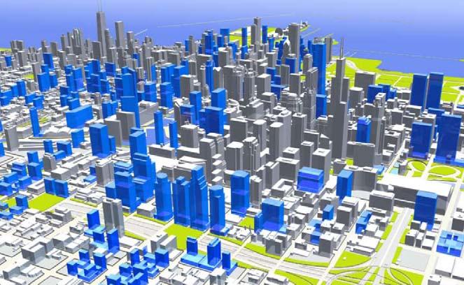
7 Office Development Map shows buildings completed since 2001 and under construction. Office market began a period of recovery in 2006 with positive absorption, dropping vacancy rates, and stable or rising rents. Several large office buildings are under construction, but few new projects are likely to start until the economy recovers. Average annual demand is forecast to be 1.2 to 1.5 million square feet. The supply is not constrained since identified prime office development sites and available space in existing buildings could accommodate approximately 25 million square feet.

8 Residential Development Map shows residential projects completed since 2001 and under construction. Residential development outpaced the forecast of the 2003 Central Area Plan An annual average of 4,200 new housing units has been added since Current conditions suggest that an annual average of 2,600 to 3,300 new housing units will be added each year through 2020.

9 Map of Existing and Proposed Schools within and adjacent to the Central Area

10 Hotel Development Map shows new and underconstruction hotels Hotel development fell slightly short of the base case projections made in 2000 due primarily to 9/11. Millennium Park boosted visitation and spurred hotel development, particularly in the Central Loop. Current economic conditions are likely to stall some of many proposed hotel projects. An annual average of 500 to 700 new hotel rooms is now forecast.

11 Retail Development Map shows retail projects completed since 2001 or under construction. Nearly 400,000 square feet were added annually from 2000 to 2007 in major projects such as NorthBridge and retail components of smaller mixed-use buildings. The emerging retail corridor along Roosevelt Road accounts for much of the new retail. 108 North State, New City Y site, and Sullivan Center are among the retail projects underway. The number of new grocery stores reflects demand from the growing residential base. Future retail development is expected to range from 250,000 to 350,000 square feet per year.

12 Institutional Development Map shows new or under construction cultural and educational facilities, churches, government buildings, visitor attractions, and medical facilities. Schools of higher education played an important part in South Loop and Central Loop development. New culture venues were added and existing facilities expanded. State-of-the-art medical facilities continue to strengthen Streeterville.
13 Maintain the Central Area as the Center of Regional Growth Market Sector Growth Benchmarks, Projected Average Annual Growth Population Employment Office (SF) Retail (SF) Cultural (SF) Residential (Units) Student Housing (Beds) Hotel (Rooms) Base 4,200 4,500 1,200, ,000 85,000 2, Opportunity 5,300 6,000 1,500, , ,000 3,
14 Economic Development and Land Use Goals Maintain Chicago s position as the economic engine of the region Enhance urban vibrancy and utilize the existing infrastructure by supporting dense residential development Reduce Chicago s carbon footprint by implementing cutting-edge environmental practices and green building techniques Enhance parks, corridors and waterfronts for residents, workers, students and visitors Better connect to the world through O Hare and Midway airports and the regional rail network Strengthen Chicago's ties to the North American economy through efficient freight movement. Support the growth envisioned by the plan by investing in transit. Frame a city/state/federal capital investment plan supplemented by private participation. Coordinate public planning by incorporating the Central Area Action Plan into the regional transportation plan, Chicago 2016 Olympic plans, and state and federal capital programs
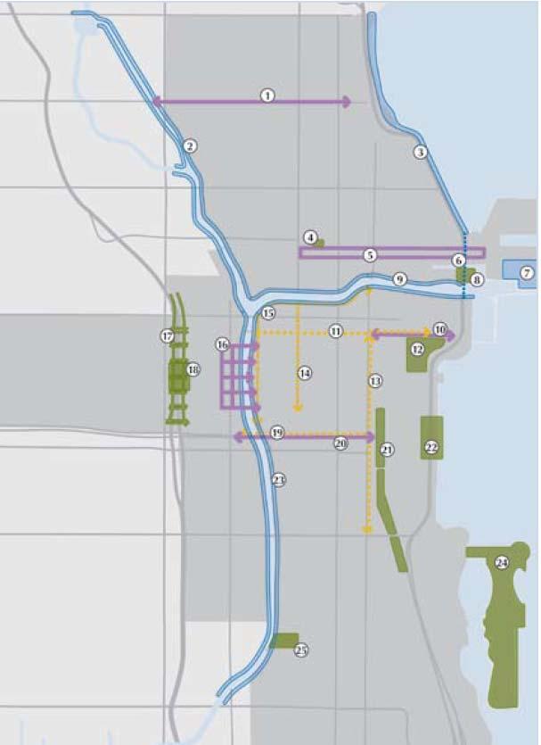
15 Transportation Key Goals and Projects
16 Transportation Goals Improve transit in Central Area Increase regional transit capacity Improve the pedestrian environment Manage traffic circulation Encourage alternative modes Improve national and international connections

17 Proposed Transit Improvements within the Central Area

18 CTA Signal & Capacity Upgrades City Role: Supporting Timeframe: Cost Estimate: $1.5B system wide Potential Funding Sources: Federal capital transit funds, local/state bonds CRITERIA RATING Transportation Expands capacity on high ridership lines Helps solve major reliability & slow-zone problems Economic Development & Land Use Maintains viable service connecting Central Loop to airports and neighborhoods Environment & Open Space Reinvests in existing highly used transit assets

19 CTA Station Modernization City Role: Project Lead Timeframe: Cost Estimate: $70M - $90M per station for 9 Central Area stations Potential Funding Sources: Local/state bonds, TIF, CMAQ CRITERIA RATING Transportation Need Improves competitiveness & accessibility of existing transit system Does not expand transit coverage Economic Development & Land Use Reinvests in the core Central Area business districts Environment & Open Space Avoids new construction by restoring and making more efficient use of existing infrastructure Olympic Impact = Yes Graphic courtesy of


20 CTA Infill Stations City Role: Partner with CTA Timeframe: Complete 4 stations by 2020 Cost Estimate: $40M $60M per station for 4 new stations Potential Funding Sources: Local/state bonds, federal capital funds, TIF, CMAQ CRITERIA RATING Transportation Improves overall connectivity and accessibility of rail system Economic Development & Land Use Expands access to and from Near South, West and North Sides all high-growth residential districts with potential for continued growth Environment & Open Space Helps maximize usage of existing infrastructure


21 Transit Passenger Info Systems City Role: Partner with RTA and CTA Timeframe: Complete upgrades to all stations by 2016 Cost Estimate: $20M Potential Funding Sources: TIF, CMAQ Graphic from CRITERIA RATING Transportation Makes using system in Central Area easier, especially for new/occasional customers Economic Development & Land Use No effect--does not change access to or travel time for key districts Environment & Open Space Helps maximize usage of existing system
, private funds (operations) CRITERIA RATING Transportation Improves travel times to both airports from Central Area terminal May be")
22 Airport Express Service City Role: Partner with CTA Timeframe: Cost Estimate: $1.5B Potential Funding Sources: State/federal funds (construction), private funds (operations) CRITERIA RATING Transportation Improves travel times to both airports from Central Area terminal May be combined with other signal/track improvements on O Hare branch Economic Development & Land Use Improves access for travelers to Central Loop employment center Enhances Chicago s attractiveness as corporate headquarters city Environment & Open Space Reduces reliance on auto/taxis for trips to airport
 Subway Economic Development & Land Use Serves main corridor of high-density office growth in West Loop Environment &")
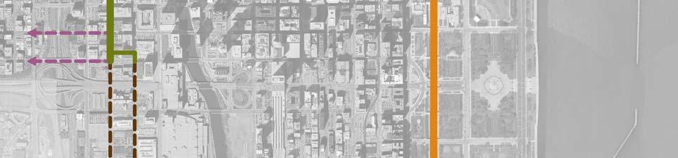
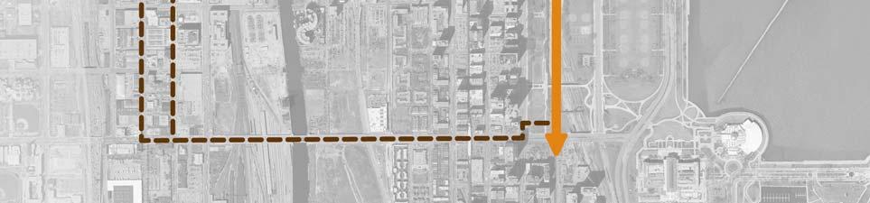
23 Clinton Street Subway City Role: Partner with RTA, CTA Timeframe: Cost Estimate: $3B Potential Funding Sources: FTA New Starts, TIF, CMAQ CRITERIA RATING Transportation Improves access to growing River North subdistrict Removes congestion from State Street (Red Line) Subway Economic Development & Land Use Serves main corridor of high-density office growth in West Loop Environment & Open Space Helps maximize usage of existing system

24 Central Area Transitways Carroll Ave Lakefront East-West (Monroe Street) Clinton Street


25 Carroll Ave Transitway City Role: Lead Timeframe: Cost Estimate: $260M Potential Funding Sources: FTA New Starts/Small Starts, State/local bonds, Transportation Improvement District, public/private partnership CRITERIA RATING Transportation Connects underserved Streeterville, improving travel to hospitals/navy Pier Provides east-west connectivity in area without major direct roadway route Economic Development & Land Use Supports residential and employment growth in Streeterville, River North, and West Loop Environment & Open Space Reduces reliance on autos for trips to Streeterville district Uses existing unused right-of-way


26 East-West Transitway (Monroe) East-West Transitway City Role: Lead Timeframe: Cost Estimate: $200M Potential Funding Sources: FTA New Starts/Small Starts, State/local bonds, Transportation Improvement District, public/private partnership CRITERIA RATING Transportation Addresses long-studied need for eastwest transit connectivity in Central Loop Connects West Loop and East Loop commuter stations Economic Development & Land Use Serves core of Central Area employment districts Environment & Open Space Improves access to Lakefront Project construction may cause major short-term disruptions

27 Lakefront Transitway Lakefront Transitway City Role: Lead Timeframe: Cost Estimate: $150M Potential Funding Sources: FTA New Starts/Small Starts, state/local bonds, Transportation Improvement District, public/private partnership CRITERIA RATING Transportation Provides rapid transit service along high-growth eastern portion of Central Area Connects Near South & Streeterville Economic Development & Land Use Connects key cultural/tourism assets along lakefront Supports Olympics bid Environment & Open Space Provides direct transit access from Near South to Lakefront parks Uses existing improved right-of-way


28 West Loop Transportation Center West Loop Transportation Center City Role: Lead Timeframe: Cost Estimate: $2B Potential Funding Sources: FTA New Starts, State bonds, TIF CRITERIA RATING Transportation Connects major West Loop hubs with local, regional, and national networks Will serve future transitway and Clinton subway projects Economic Development & Land Use Invests in West Loop, the area driving Central Area employment growth Environment & Open Space Supports all alternatives to auto use


29 INSERT AMTRAK GRAPHIC?? INSERT REDEVELOPMENT PROPOSAL GRAPHIC?? New Intermodal Facility Streetway & Pedestrian Access Improvements Passenger Area Improvement s Platform & Capacity Enhancement s = existing access point Union Station Upgrades City Role: Partner with Amtrak, Metra, RTA Timeframe: Cost Estimate: $80M - $100M Potential Funding Sources: State/local bonds, TIF, CMAQ, Amtrak CRITERIA RATING Transportation Improves efficiency of busiest transfer site in the region Improves comfort, accessibility, & potential capacity of existing service Economic Development & Land Use Enhances West Loop as hub of new office growth Environment & Open Space Helps maximize usage of landmark Central station Area Action Plan

30 Wacker Drive Reconstruction City Role: Lead Timeframe: E/W portion completed N/S leg requires funding ( ) Cost Estimate: $350M for N/S leg Potential Funding Sources: State/local bonds, TIF CRITERIA RATING Transportation Reinvests in major streetway abutting river s South Branch Lower level provides delivery and parking garage access Economic Development & Land Use Improves auto & pedestrian environment in most actively developed office corridor in Central Area Environment & Open Space Adds streetscaping elements and green infrastructure


31 Smoothed Curve Improved Auto & Ped Access Graphic courtesy of More Lakefront Open Space North LSD Improvements City Role: Partner with IDOT Timeframe: Cost Estimate: $200M Potential Funding Sources: Local/state bonds, CMAQ, Federal earmarks CRITERIA RATING Transportation Improves unsafe curve at Oak St. and intersection at Chicago Ave. Provides more space for bicycle and pedestrian paths along Lakefront Economic Development & Land Use Improves access to growing employment and residential concentrations in Streeterville Environmental & Open Space Dramatically increases open space amenities and access to Lakefront

32 Regional Transit Projects- Metra and CTA
33 Urban Design, Waterfront & Open Space Key Goals and Projects
34 Urban Design, Waterfront & Open Space Goals Strengthen Chicago as an environmentally sustainable city Strengthen the Lakefront as Chicago's great public space Develop the Chicago Riverfront as a continuous system of premier public places Create a new generation of downtown parks Complete the Central Area s framework of richly landscaped streets and boulevards

35 Areas of Special Interest

36 Urban Form
37 Parks and Streetscapes
38 Urban Design Projects Streetscape Improvements Building Lighting Enhancement Kennedy Corridor Improvements and Cap

39 Streetscape Improvements City Role: Lead by CDOT Timeframe: Cost Estimate: Varies Project Description: Expand streetscape upgrades that have benefited prominent north/south streets within the Central Area. To complement these, improvements are proposed for east/west streets to enhance motorist and pedestrian mobility and to anchor investment in surrounding areas. Improvements should incorporate environmentally friendly design elements and materials from the City s Green Alleys and Streets initiative and from the Green Urban Design Task Force.

40 Lighting Enhancements City Role: Involvement of CDOT. DLUP, DCD, DOE Timeframe: Cost Estimate: $400,000 Project Description: Enhance structure lighting. A program of improvements along Michigan Avenue has been developed by Schuler Shook. Michigan should serve as the pilot for similar programs on LaSalle and Randolph. A grant or loan program should be established to facilitate private sector implementation. Lighting improvements guidelines should include recommendations from the Lights Out Chicago program, which protects migratory birds, saves energy, and decreases maintenance costs.

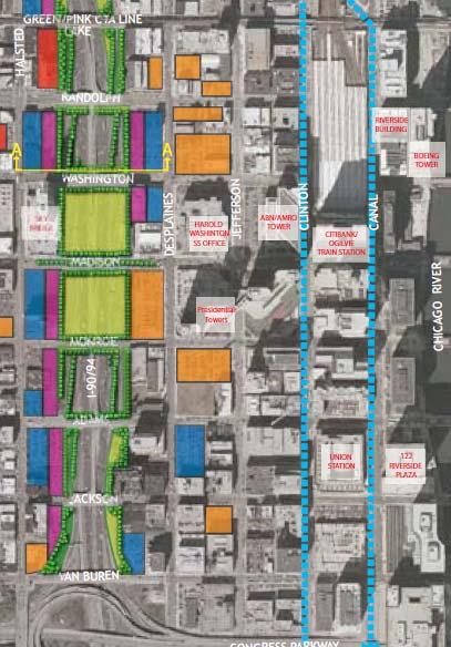
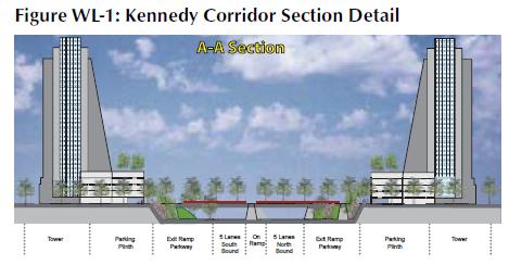
41 Kennedy Corridor Enhancements & Cap City Role: Lead by CDOT Timeframe: Improvements Kennedy Cap Cost Estimate: Improvements - $10 million Kennedy Cap - $500 million Project Description: Build a cap atop the Kennedy to improve connections between the Central Loop and the West Loop. Short-term: Traffic calming, landscaping, pedestrian mobility enhancements. Long-term: Create parkland over the Kennedy between Monroe and Washington. New urban greenway would improve air quality and reduce noise pollution.
42 Waterfront Projects Lakefront Trail expansion Gateway Harbor Chicago Riverfront System

43 Lakefront Trail Expansion City Role: Involves CDOT, DZLUP, DCD, CPD Timeframe: Cost Estimate: $177 million Project Description: Expand the Lakefront Trail lakeward between North Ave. and Navy Pier by up to 200 feet. Introduce landscaping to create parkland and expanded pedestrian and bicycle paths. This project should be undertaken in conjunction with North Lake Shore Drive improvements at the Oak St. curve and at Chicago Ave.

44 Gateway Harbor City Role: Lead by CPD Timeframe: Cost Estimate: $30 million Project Description: Build new boat marina and amenities connecting Dime Pier to the Navy Pier Headlands. Also explore feasibility of establishing direct boat access to Navy Pier at river level by relocating a wall segment northwest of the Chicago Locks.

45 Main Branch Riverfront Lake Shore Drive to Franklin City Role: Involves MWRD, CDOT, DZLUP, DCD Timeframe: Phase Phase Cost Estimate: $92 million Project Description: Create a continuous multi-level Riverwalk along the north side of the Chicago River with underbridge connections at Michigan Ave. and Lake Shore Drive to DuSable Park. Establish clearly identified onstreet connections west of Michigan Ave and east of Wells Street ($12 million). Develop a dock level Riverwalk along the south side of the Chicago River with under bridge and vertical connections for continuous water access. ($80 million).

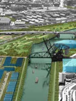
46 North Branch Riverfront Lake to Halsted City Role: Involves CDWM, CDOT, DZLUP, DCD Timeframe: Cost Estimate: $75 million Project Description: Develop the North Branch Riverfront with: ADA-accessible boatyard Off-river connection from Kinzie Park Under-bridge connection to Wolf Point A street level park south of Riverbend for future development Create a river level trail on the east side of the river to connect lower level walks Develop Riverwalk north of River Village to the North Ave. Turning Basin Improve river access at the east bank between North and Division Landscape west bank from Grand Ave. to North Ave

47 South Branch Riverfront Lake to Harrison City Role: Involves CDWM, CDOT, DZLUP, DCD Timeframe: Cost Estimate: $15 million Project Description: Develop a multi-component Riverwalk on the South Branch in the West Loop and Central Loop. Includes a contiguous street level Riverwalk with improved connections and access to large plazas, and a dock level Riverwalk on the east bank. Will also include adjacent green space and vertical connection near Van Buren St.

48 South Branch Riverfront Harrison to Stewart City Role: Involves CDWM, CDOT, DZLUP, DCD Timeframe: Cost Estimate: $75 million Project Description: Develop a multicomponent Riverwalk on the South Branch in South West Loop, River South, and Chinatown. Connection to River City Vertical connection at Harrison St. New pedestrian and vehicular crossings Underbridge connections at Roosevelt and 18th St. Public park in future Franklin Point development On-street connections near Ping Tom Park to future Riverwalk development at East Canal Origins Park Landscaping on west riverbank

49 Open Space Projects Queen s Landing Northerly Island Grant Park Railscape DuSable Park Ping Tom Park Phase 2

50 Queen s Landing City Role: CDOT Lead Timeframe: Cost Estimate: $500,000 Project Description: Improve pedestrian access between Buckingham Fountain in Grant Park and the cross-lake Shore Drive lakefront. This a key component of the Grant Park Framework Plan and includes improved crosswalks and signage. Queen s Landing is the spot at which Queen Elizabeth II came ashore during her 1959 visit.

51 Northerly Island City Role: CPD lead Timeframe: Cost Estimate: $75 million Project Description: Create a state-ofthe-art park with sustainable design principles to serve as an outdoor conservation museum.


52 Grant Park Railscape City Role: Involves RTA, Metra, DZLUP, DCD, CPD Timeframe: Cost Estimate: $32.6 million Project Description: Screen the railroad tracks throughout Grant Park and south to Museum Place. The appearance of the existing open railroad trench could be improved by a green screen over the tracks. Explore potential to reduce the former rail service yard area generally known as the pennant lot (as depicted in red) to add park land.
53 DuSable Park City Role: Involves CPD, CDOT, DZLUP, DCD Timeframe: Cost Estimate: $17 million Project Description: Develop a public park at the inlet of the Chicago River at Lake Michigan to commemorate Chicago s founding pioneer. This park will be build through a publicprivate partnership with the developer of The Spire.

54 Ping Tom Park Phase II City Role: Involves CPD, DZLUP, CDOT, Canadian National Railroad Timeframe: Various phases Cost Estimate: $38 million Project Description: Develop Phase 2 of Ping Tom Park. In 2002, the Chicago Park District acquired 5 acres to expand the park to the northeast. A former industrial site, the land will be cleaned up and redeveloped into a spacious community park with ball and soccer fields, a field house, and a swimming pool.
55 Cost & Phasing
56 Grand Total Transportation = Urban Design = Grand Total = $14.24 Billion $1.31 Billion $15.55 Billion
57 Phased Investment Cost (in 2007 $) Transportation = $5,926,000,000 Urban Design = $ 281,100,000 Total = $6,207,100, Transportation = $4,765,000,000 Urban Design = $ 443,000,000 Total = $5,208,000, Transportation = $3,550,000,000 Urban Design = $ 585,000,000 Total = $4,135,000,000
58 Central Area Transit Regional Transit Capacity Pedestrian Environment Traffic Circulation Alternative Modes National/International Connections Transportation CTA Station Modernization (4 Stations) Carroll Avenue Transitway Clinton Street Transitway CTA Infill Station (Morgan - Green/Pink) Transit/Passenger Information Systems CTA Signal & Capacity Upgrade CREATE Program (initial) Metra UP-W Upgrades Metra UP-NW Extension & Upgrades Union Station Access/Intermodal Upgrade Wacker Drive Reconstruction (Phase II) Wells-Wentworth Connector (Phase I) West Loop Bicycle Station Airport Rail Express Service Union Station Capacity/Facility Upgrade Subtotal Cost (in 2007 $) $360,000,000 $260,000,000 $60,000,000 $60,000,000 $10,000,000 $1,500,000,000 $750,000,000 $536,000,000 $419,000,000 $30,000,000 $350,000,000 $30,000,000 $1,000,000 $1,500,000,000 $60,000,000 $5,926,000,000
59 Urban Design Cost (in 2007 $) Urban Design Waterfront Open Space Congress Parkway Grand & Illinois Kennedy Corridor Enhancements East Randolph Lighting Enhancements (Michigan, Congress & Wacker) Main Branch Riverfront (Phase I) Gateway Harbor Chicago River Management Entity Northerly Island Park Improvements Grant Park Improvements North Ping Tom Phase II (Site Dev./Railway Underpass) DuSable Park Pedestrian Connection at Queen s Landing Subtotal $19,000,000 $19,000,000 $10,000,000 $8,750,000 $600,000 $46,000,000 $30,000,000 $250,000 $75,000,000 $35,000,000 $20,000,000 $17,000,000 $500,000 $281,100,000
60 Transportation Cost (in 2007 $) Central Area Transit Regional Transit Capacity Traffic Circulation West Loop Transportation Center Clinton Subway (Phase I) CTA Station Modernization (3 Stations) East-West Transitway Lakefront Transitway CTA Infill Station (Cermak - Green) CTA Infill Station (Division - Brown/Purple) Transit/Passenger Information Systems CREATE Program (Completion) North Lake Shore Drive Improvements South Branch Bridge at Taylor Street Wells-Wentworth Connector (Phase II) Subtotal $2,000,000,000 $1,000,000,000 $270,000,000 $200,000,000 $150,000,000 $60,000,000 $60,000,000 $10,000,000 $750,000,000 $200,000,000 $50,000,000 $15,000,000 $4,765,000,000
61 Urban Design Cost (in 2007 $) Urban Design Waterfront Open Space West Loop/Union Station Area Streetscape Division Streetscape Lighting Enhancements (LaSalle & Randolph) Lakefront Trail Expansion North Branch Riverfront (River North) Main Branch Riverfront (Phase II) South Branch Riverfront (Downtown) Lakefront Trail Bridge Ping Tom Phase II (Multi-Purpose Center/Boathouse) Grant Park South Railscape Grant Park Central Railscape Central Station Area Railscape Subtotal $33,000,000 $21,000,000 $400,000 $177,000,000 $75,000,000 $46,000,000 $15,000,000 $25,000,000 $18,000,000 $17,200,000 $7,900,000 $7,500,000 $443,000,000
62 Transportation Cost (in 2007 $) Central Area Transit Pedestrian Environment Traffic Circulation Clinton Subway (Phase II) CTA Station Modernization (2 Stations) CTA Infill Station (Clark/18th - Orange) Pedestrian Bridges over River (Streeterville, W. Loop) South Branch Bridge at 16th or Polk Street Subtotal $2,000,000,000 $180,000,000 $60,000,000 $60,000,000 $50,000,000 $2,350,000,000
63 Urban Design Urban Design Waterfront Open Space Kennedy Cap South Branch Riverfront (River South) Fort Dearborn Park Subtotal Cost (in 2007 $) $500,000,000 $75,000,000 $10,000,000 $585,000,000
64 Regional Supporting Transit Phase Project Projects ( ) Cost (in 2007 $) CTA Orange Line Extension CTA Red Line Extension CTA Yellow Line Extension Metra South East Line Service Development CTA Circle Line Construction Metra Star Line Construction Subtotal $300,000,000 $1,000,000,000 $300,000,000 $550,000,000 $3,000,000,000 $1,100,000,000 $6,250,000,000
65 2007 Capital Budget Programs Selected Programs Total capital budget was $2.0 billion in 2007 Selected programs compose ¼ of total, or $423 million Transportation $180,788,815 $181 M Economic Development $113,984,623 $114 M CitySpace $14,892,555 $15 M Neighborhood Infrastructure $113,437,563 $113 M Source: City of Chicago
66 2007 Capital Budget Funding Sources Funding Sources for CitySpace, Economic Development, Neighborhood Infrastructure and Transportation Programs State Funds $78,478,000 19% G.O. Bonds $184,684,961 43% TIF $34,415,329 8% Source: City of Chicago Other Federal Funds $
67 Transit Capital Funding Sources United States Top 50 Transit Agencies State government 12% Other sources <1% Federal government 35% Local sources 53% Source: RTA, Moving Beyond Congestion
68 Funding Strategy Recommendations Target TIF funds for major capital projects Bond against future TIF revenues when possible Consider special area funding mechanisms
69 Potential Funding Sources Federal Transportation Funds Federal Economic Stimulus Funds State Capital Program Private Investment CREATE, Corporate Donations Public-Private Partnerships General Obligation Bonding
70 Chicago is Awesome! Thank You!
Central Area Action Plan. Adopted by the Chicago Plan Commission August 20, ChicaGo Central Area Action Plan
 Central Area Action Plan Adopted by the Chicago Plan Commission August 20, 2009 ChicaGo Central Area Action Plan Action plan table of contents The Central Area Action Plan (CAAP) contains a wealth of information
DRAFT ROOSEVELT ROAD. District Recommendations. Figure 5.23 The Roosevelt Road Corridor
 CHAPTER 5 Figure 5.23 The Road Corridor Road will develop as a mixed-use corridor, emphasizing regional retail, west of the river and mixed-use development east of the river. KEY RECOMMENDATIONS 1. High
DRAFT. Waterfronts and Open Spaces. 10 The Riverfront Open Space System
 CHAPTER 4 Waterfronts and Open Spaces 10 The Riverfront Open Space System 12 Planned, proposed and envisioned riverfront recommendations. Figure 4.3.23 The riverfront will become a major new public amenity
Chapter 4 : THEME 1. Development Framework DRAFT. Direct growth to create a dynamic Central Area made up of vibrant, mixed-use districts
 Chapter 4 : THEME 1 Direct growth to create a dynamic Central Area made up of vibrant, mixed-use districts CHICAGO CENTRAL AREA PLAN 43 Figure 4.1.1 Fig. 4.1.2 High-Density, Mixed-Use Corridors Fig. 4.1.3
Great Plans for a Great City
 CHAPTER 1 Great Plans for a Great City 1 Figure 1.1 South Michigan Avenue today Figure 1.2 South Michigan Avenue will be one of many higher intensity, mixed-use corridors that will extend out from the
The University District envisions, in its neighborhood
 Envisioning the University District Link Light Rail in Seattle s neighborhoods CIY OF SEALE CONCEP-LEVEL SAION AREA PLANNING RECOMMENDAION RESOLUION # 30165 EXHIBI L Vision 08.2000 he University District
CHAPTER 7: Transportation, Mobility and Circulation
 AGLE AREA COMMUNITY Plan CHAPTER 7 CHAPTER 7: Transportation, Mobility and Circulation Transportation, Mobility and Circulation The purpose of the Transportation, Mobility and Circulation Chapter is to
Windsor Locks Transit-Oriented Development Planning Grant Request. Project Background
 Windsor Locks Transit-Oriented Development Planning Grant Request Project Background Downtown Windsor Locks runs along Main Street in the vicinity of the intersection of Routes 159 and 140. The current
Harlem Avenue Corridor Plan: Corridor Planning Across Municipal Boundaries
 Harlem Avenue Corridor Plan: Corridor Planning Across Municipal Boundaries Heather Tabbert, Manager, Local Planning and Programs Division Regional Transportation Authority (RTA) Jen McNeil Dhadwal, Principal
Ashland BRT Environmental Assessment: logos of CTA, CDOT, Chicago Department of Housing and Economic Development
 Ashland BRT Environmental Assessment: logos of CTA, CDOT, Chicago Department of Housing and Economic Development Overview The Chicago Transit Authority (CTA), in partnership with the Chicago Department
Chapter 4. Central Area Planning Subdistricts. Chicago Central Area ACTION Plan
 Chapter 4 Central Area Planning Subdistricts Page 4-2 CENTRAL AREA SUBDISTRICTS The City of Chicago s Department of Zoning and Land Use Planning divides the Central Area into twelve planning subdistricts.
The Village of Shirlington
 The Village of Shirlington Suburban Smart Growth Without Rail Transit July 2018 Agenda History (1940 to present) Attributes and Outcomes Lessons Learned Setting the Stage Arlington County Arlington is
LEED-ND 101: Practical Strategies for Achieving Sustainability Goals. Travis Parker Lakewood Planning Director
 LEED-ND 101: Practical Strategies for Achieving Sustainability Goals Travis Parker Lakewood Planning Director Metro Vision Idea Exchange Oct 11, 2012 West Corridor Stations West Corridor Overview West
Promoting Economic Development Through Upfront SEPA Review: Lessons from South Downtown Tacoma
 Promoting Economic Development Through Upfront SEPA Review: Lessons from South Downtown Tacoma 1 This session will focus on the City of Tacoma s South Downtown Subarea Plan and associated Non-Project SEPA
Albert Lea. Redevelopment Plan. 701 Xenia Avenue South, Suite 300 Minneapolis, MN Tel: (763) Fax: (763) wsbeng.
 Fax: (763) wsbeng.") Albert Lea Redevelopment Plan 701 Xenia Avenue South, Suite 300 Minneapolis, MN 55416 Tel: (763) 541-4800 Fax: (763) 541-1700 wsbeng.com Albert Lea Redevelopment Plan Table of Contents Composite Districts...
Albert Lea Redevelopment Plan 701 Xenia Avenue South, Suite 300 Minneapolis, MN 55416 Tel: (763) 541-4800 Fax: (763) 541-1700 wsbeng.com Albert Lea Redevelopment Plan Table of Contents Composite Districts...
Potential Green Infrastructure Strategies May 6, 2015 Workshop
 Potential Green Infrastructure Strategies May 6, 2015 Workshop Background The City of Cortland is developing the Tioughnioga Urban Headwaters Green Infrastructure Action Plan with funding from the National
Northwest Rail Corridor and US 36 BRT Development Oriented Transit Analysis 4.4 STATION AREA FINDINGS
 4.4 STATION AREA FINDINGS Each station is different, and each one requires a separate set of recommendations based on the vision for the site. This section outlines an initial TOD strategy and recommendations
38 Queen s University Campus Master Plan Part 1
 38 Queen s University Campus Master Plan Part 1 46 The Campus at the City Scale Chapter 4 The Campus at the City Scale 39 Queen s is an urban University centrally located in Kingston. Decisions made by
Implementation Guide Comprehensive Plan City of Allen
 Implementation Guide 2030 Comprehensive Plan City of Allen DRAFT 2015 Implementation Guide Allen 2030 Comprehensive Plan INTRODUCTION The Comprehensive Plan serves as a guide for the growth and development
Today Land & People. Northeast Nampa Gateway District. Employment. Land Use Characteristics. Demographics. Current Zoning
 Today Land & People Employment Major employers include Saint Alphonsus, the College of Western Idaho, the Auto Mall, Sorrento Lactalis and Walmart. 3,004 jobs in 2010 (COMPASS-CIM 2040 TAZ data) 4,345
MONTGOMERY COUNTY METRO STATION AREA DESIGN CHARRETTE
 MONTGOMERY COUNTY METRO STATION AREA DESIGN CHARRETTE Shady Grove Metro Station Area Charrette Closing Presentation October 25-28, 2000 MONTGOMERY COUNTY, MD M-NCPPC Design Collective, Inc. Architects
Corridor Vision. 1Pursue Minnehaha-Hiawatha Community Works Project. Mission of Hennepin County Community Works Program
 1Pursue Minnehaha-Hiawatha Community Works Project Minnehaha-Hiawatha Community Works is a project within the Hennepin Community Works (HCW) program. The mission of the HCW program is to enhance how the
Planned Manufacturing District Review
 Mayor Emanuel s Industrial Corridor Modernization Planned Manufacturing District Review North Branch Framework Implementation Chicago Plan Commission July 20, 2017 Rahm Emanuel, Mayor David Reifman, Commissioner
Pedestrian and Bike Bridge LOGO
 6.2.2 Pedestrian and Bike Bridge The proposed pedestrian and bike crossing re-envisions the existing bridge at Pismo Creek on Cypress Street. The bridge is currently underutilized by vehicular through
March 1, PWG Meeting #4
 March 1, 2013 PWG Meeting #4 1 Meeting Agenda 2 History & Overview Circle Interchange was built in the late 1950 s and early 1960 s, and the facility is in need of major repair or reconstruction. 3 History
Table of Contents. Elm Avenue Improvement Plan City of Waco, Texas. Introduction 1. Existing Context 1 Figure 1 2.
 Table of Contents Introduction 1 Existing Context 1 Figure 1 2 Plan Guidelines 3 Future Urban Form 4 The West-End 4 Main Street 6 The East-End 7 Figure 2 9 Public Improvement Recommendations 7 General
Planning for Waterfront Communities
 Planning for Waterfront Communities Redevelopment Ready Communities Supplemental Training Program OFFICE OF THE GREAT LAKES Waterfront Community Best Practices and Guidelines New supplemental criteria
The transportation system in a community is an
 7 TRANSPORTATION The transportation system in a community is an important factor contributing to the quality of life of the residents. Without a sound transportation system to bring both goods and patrons
REGIONAL ACTIVITY CENTER
 DRAFT REGIONAL ACTIVITY CENTER 70 EAST BENCH MASTER PLAN DRAFT 06 Introduction The East Bench Regional Activity center is comprised of large educational, research, medical, and employment centers. These
Preliminary Recommendations Tk Takoma/Langley Crossroads Sector Plan
 Preliminary Recommendations Tk Takoma/Langley Crossroads Sector Plan Vision is to achieve a Transit Oriented, pedestrian friendly Community that Celebrates and builds upon the cultural Diversity of the
1.0 Circulation Element
 5/9/18 1.0 Circulation Element 1.1 Introduction As growth and development occur in Apache County, enhancements to its circulation system will be necessary. With time, more roads will be paved and air and
I-84 Hartford Project Open Planning Studio #12. April 25, 2017
 I-84 Hartford Project Open Planning Studio #12 April 25, 2017 Meeting Agenda 1. I-84 Hartford Project alternatives update 2. Multimodal station area planning 3. I-84 / I-91 Interchange Study coordination
Downtown Dubuque...it s a great time.
 Downtown Dubuque...it s a great time. Your timing could not be better to invest in Downtown. With hundreds of millions in public and private investment occurring on the City s downtown waterfront, millions
CHARLES PUTMAN CHARLES PUTMAN AND ASSOCIATES, INC
 MEMORANDUM CHARLES PUTMAN & ASSOCIATES, INC. LAND DEVELOPMENT CONSULTANTS PLANNING ZONING PERMITTING 4722 NW Boca Raton Boulevard, Suite C-106 Boca Raton, Florida 33431 Phone: 561/994-6411 FAX: 561/994-0447
8implementation. strategies
 PROGRAM STRATEGIES 8implementation strategies T he implementation actions of this chapter are designed to support and carry out the land use, economic development, transportation, urban design, and program
South Davis County COMMUNITY SPOTLIGHT
 South Davis County COMMUNITY SPOTLIGHT Davis/SLC Community Connector Bus Rapid Transit line connecting SLC & Davis County RTP Phase 1 Project Generate 3,100 average weekday riders Relieve congestion on
Linking Land Use and Transportation
 Linking Land Use and Transportation NJ s Experience January 18, 2006 NYMTC - PFAC Mark Stout Planning & Development New Jersey Department of Transportation Where We Are Los Angeles, CA San Francisco, CA
EXISTING PLANS Harriet Festing Center for Neighborhood Technology Midlothian Community Meeting March 12, 2015
 EXISTING PLANS Harriet Festing Center for Neighborhood Technology Midlothian Community Meeting March 12, 2015 BENEFITS Bring economic, community + environmental benefits Enhance property values Use
NEIGHBORHOOD DESIGN ELEMENT
 NEIGHBORHOOD DESIGN ELEMENT INTRODUCTION The following recommendations constitute an urban design oriented "neighborhood analysis" of Plantation. It is an optional Comprehensive Plan Element. The five
Executive Summary. NY 7 / NY 2 Corridor
 Executive Summary NY 7 / NY 2 Corridor Transportation and Land Use Study December 2005 Prepared for: Town of Colonie Capital District Transportation Committee Prepared by: Introduction: Land use decisions
Issues Requiring Future Study
 Issues Requiring Future Study Transportation planning is an ongoing process that tends to identify new issues as it finds solutions for others. Some issues are so complex that a solution to one problem
Study Area. Capitol Way. Greening America s Capitals 11/13/2014. A Greening America s Capitals Project
 Olympia, WA: Greening Capitol Way Supporting Communities move towards sustainability is a priority for the federal government. A Greening America s Capitals Project Office of Sustainable Communities U.S.
Making Transit Oriented Development Work For Boonton, NJ
 Making Transit Oriented Development Work For Boonton, NJ Bloustein School of Planning and Public Policy Studio Dan Burton Loannie Dao Webster Slater Brandon Williams Ian Watson Maria Laham Nicola Mammes
C. Westerly Creek Village & The Montview Corridor
 C. Westerly Creek Village & The VISION Community Vision When the goals of the city are achieved Westerly Creek Village, a distinctive community defined by Montview Boulevard and Westerly Creek, is a strong
Urban Analysis. Downtown Zanesville like any city, has been physically modified through time as it
 Urban Analysis As a part of the consulting team s reconnaissance effort, an urban analysis was performed. Before the future of a place can be envisioned, one must understand the physical characteristics
Riverwalk Dreams compiled by Thomas P. Healy November 16, 2017
 Riverwalk Dreams compiled by Thomas P. Healy November 16, 2017 1986 Ripple Village Plan: A neighborhood plan developed by the City of Indianapolis Department of Metropolitan Development s Division of Planning
WEST LOOP DESIGN GUIDELINES CHECKLIST
 WEST LOOP DESIGN GUIDELINES CHECKLIST Section 1.0 General Strategies 1.1 DESIGN EXCELLENCE: ENCOURAGE HIGH QUALITY AND INNOVATIVE DESIGN OF NEW BUILDINGS WITHIN THE WEST LOOP WITHOUT BEING PRESCRIPTIVE
WELCOME and introduction
 1 WELCOME and introduction Mobility Hub Locations within Burlington STUDY OVERVIEW STUDY OBJECTIVES The City of Burlington is developing four Area Specific Plans, one for each of Burlington s Mobility
Kinzie Industrial Corridor
 Mayor Emanuel s Industrial Corridor Modernization Kinzie Industrial Corridor Fulton Market Innovation District Plan Implementation October 19, Rahm Emanuel, Mayor David Reifman, Commissioner Dept. of Planning
THE GREEN VISION WORKSHOP Friday, November 6, 2009
 THE GREEN VISION WORKSHOP Friday, November 6, 2009 SUSTAINABLE LONG RANGE PLANNING IN SANTA MONICA Eileen Fogarty Director, Planning and Community Development GREEN BUILDINGS Santa Monica has the most
Dyersville Downtown Plan. Open House October 24, 2017
 Dyersville Downtown Plan Open House October 24, 2017 What is a Comprehensive Plan? - Vision - Guidance for decisions - Basis for regulations What is a Downtown Plan? - Understand priorities - Identify
The Master Plan Framework
 The Master Plan Framework The East Harbour Master Plan advances the development of 60 acres of former industrial lands east of the Don River. The Master Plan outlines a vision for a vibrant, transit-oriented
Tysons Circulator Study: Process and Preliminary Results Summary. March 2012
 Tysons Circulator Study: Process and Preliminary Results Summary March 2012 Background: 1. The Comprehensive Plan for the Tysons Corner Urban Center calls for a System of Circulators in Tysons Corner to:
City of Ennis. Downtown Master Plan Catalyst Projects
 City of Ennis Downtown Master Plan Catalyst Projects Revised Framework Plan REVISED Project Types and Descriptions Project Types A. Visitor Attracting Projects: Projects in this category are intended to
40 Years of Smart Growth Arlington County s Experience with Transit Oriented Development in the Rosslyn-Ballston Metro Corridor
 40 Years of Smart Growth Arlington County s Experience with Transit Oriented Development in the Rosslyn-Ballston Metro Corridor A presentation by the Arlington County Department of Community Planning,
LAKESHORE EAST - IJKL
 LAKESHORE EAST - SECOND COMMUNITY MEETING 9 AUGUST 08 RIVERWA LK LEVEL) (INTERMEDIATE COLUMBUS DR CHICAGO E WACKER HYATT REGENCY I CHICAGO RIVER NAVY PIER CHICAGO RIVE RWALK DR (UPP ER LEVEL RIVER GATEWAY
RESOLUTION NO. R Refining the route, profile and stations for the Downtown Redmond Link Extension
 RESOLUTION NO. R2018-32 Refining the route, profile and stations for the Downtown Redmond Link Extension MEETING: DATE: TYPE OF ACTION: STAFF CONTACT: Capital Committee Board PROPOSED ACTION 09/13/2018
LPC Goals and Strategies. Transportation and Connectivity Employment Opportunities Food Access Waterfront Access Livable Communities
 LPC Goals and Transportation and Connectivity Employment Opportunities Food Access Waterfront Access Livable Communities Transportation and Connectivity Goal: Safe and ready access of all types allowing
12/9/2013. HOLLYWOOD/PINES CORRIDOR PROJECT AMPO 2013 Annual Conference October 24, Our Perspective. Broward.
 HOLLYWOOD/PINES CORRIDOR PROJECT AMPO 2013 Annual Conference October 24, 2013 Our Perspective Broward Fort Lauderdale 1 Broward Metropolitan Planning Organization Fort Lauderdale Fort Lauderdale Skyline
Atlanta BeltLine, Inc. Pathways to Urban Sustainability
 Atlanta BeltLine, Inc. Pathways to Urban Sustainability September 30, 2010 WHAT IS THE ATLANTA BELTLINE? Transit 22-mile loop Parks 1300 + new acres Trails 33 miles Jobs & Economic Development 20 areas,
Hopkins. Development Guidelines May Overview. Sponsored by: Blake Road Corridor Collaborative City of Hopkins
 Hopkins Blake Road LRT Station Area Development Guidelines May 2015 Sponsored by: Blake Road Corridor Collaborative City of Hopkins Overview Hopkins is a dynamic community of over 17,000 residents located
Plano Tomorrow Vision and Policies
 Plano Tomorrow Vision and Policies PLANO TOMORROW PILLARS The Built Environment The Social Environment The Natural Environment The Economic Environment Land Use and Urban Design Transportation Housing
Corridors. Re-vitalize our Corridors and Gateways
 Corridors Re-vitalize our Corridors and Gateways Artist s rendering from the 287 Strategic Plan, 2015 Corridors are the major throughways of Loveland but they also provide important commercial, community
DISCUSSION TOPIC: ST JOHNS RIVER & ITS TRIBUTARIES (BPII) 2030 COMPREHENSIVE PLAN POLICES AND REGULATORY FRAMEWORK
 2030 COMPREHENSIVE PLAN POLICES AND REGULATORY FRAMEWORK") DISCUSSION TOPIC: ST JOHNS RIVER & ITS TRIBUTARIES (BPII) 2030 COMPREHENSIVE PLAN POLICES AND REGULATORY FRAMEWORK St. John s River & Its Tributaries Issue Summary: The St. Johns River is an important
DISCUSSION TOPIC: ST JOHNS RIVER & ITS TRIBUTARIES (BPII) 2030 COMPREHENSIVE PLAN POLICES AND REGULATORY FRAMEWORK St. John s River & Its Tributaries Issue Summary: The St. Johns River is an important
Gold Line Bus Rapid Transit Transit Oriented Development (BRTOD) Helmo Station Area Plan
 Helmo Station Area Plan") Appendix F Gold Line Bus Rapid Transit Transit Oriented Development (BRTOD) Helmo Station Area Plan Introduction and Purpose of the Plan The Gold Line Bus Rapid Transit facility is an eleven-mile dedicated
Appendix F Gold Line Bus Rapid Transit Transit Oriented Development (BRTOD) Helmo Station Area Plan Introduction and Purpose of the Plan The Gold Line Bus Rapid Transit facility is an eleven-mile dedicated
TOWN COUNCIL / PLANNING COMMISSION
 Workshop #3 TOWN COUNCIL / PLANNING COMMISSION January 20, 2011 Consultant Team In Attendance Tonight BMS Design Group Nevada City and San Francisco Michael Smiley, AICP, ASLA Partner-in-Charge Nancy L.
East Central Area Plan
 East Central Area Plan Steering Committee Meeting March 8 th, 2018 CHUN Tears McFarlane House Vision Statement Development Opportunities Analysis Vision Elements 1. Equitable, Affordable and Inclusive
PLAN ELEMENTS WORKSHOP. April 5, 2016
 PLAN ELEMENTS WORKSHOP April 5, 2016 needs more housing. But there is no one-size fits-all solution. Every neighborhood has its own character. In some places, density is not only appropriate it is badly
Mississippi Skyway Preliminary Engineering Report
 EXECUTIVE SUMMARY Mississippi Skyway Preliminary Engineering Report CITY OF RAMSEY, MINNESOTA DECEMBER 2014 City of RAMSEY EXECUTIVE SUMMARY Project Need and Intent The Mississippi Skyway pedestrian bridge
VILLAGE OF ROMEOVILLE
 VILLAGE OF ROMEOVILLE COMPREHENSIVE PLAN FRAMEWORK PLAN, KEY STRATEGIES & GUIDING PRINCIPLES December 8, 2016 KEY PLANNING THEMES 2 KEY PLANNING THEME #1 ADVANCING A BALANCED ECONOMIC BASE KEY PLANNING
City of Long Beach. creating vibrant and exciting places
 City of Long Beach creating vibrant and exciting places Land Use Element Urban Design Element Overview of the two draft General Plan elements Discuss areas of change Economic goals of the plans Case study
CITY COUNCIL AGENDA REPORT
 CITY COUNCIL AGENDA REPORT Subject: COUNCIL MOTION LRT ALIGNMENT REMOVAL FROM THE TRANSPORTATION MASTER PLAN On February 10, 2016 Councillor Hughes provided notice in accordance with Section 23 of Procedure
Chicago Neighborhoods 2015: Assets, Plans and Trends A project of The Chicago Community Trust
 NORTHWEST SIDE Jefferson Park Milwaukee/Lawrence Corridor Study August 2008 Community Areas: Jefferson Park Department of Planning and Development, Skidmore, Owings & Merrill LLP, Applied Real Estate Analysis,
Workshop #3 June 13, 2016
 Downtown Ocoee Master Plan Workshop #3 June 13, 2016 Our Team Our Team and Tonight s Goal Quick Recap: Why a Downtown Plan? How are we developing the plan? How can you still be involved? What s left to
Chapter 2 District Context
 Chapter 2 District Context 2.1 REGIONAL OVERVIEW The City of Tampa is located on the west coast of Florida, anchoring a metropolitan region that includes diverse and economically vibrant communities. Tampa
U T D N o r t h C a m p u s T O D and D o w n t o w n D e n t o n T O D
 U n i v e r s i t y o f T e x a s a t D a l l a s C i t y o f R i c h a r d s o n U T D N o r t h C a m p u s T O D and D o w n t o w n D e n t o n T O D Rick Leisner, AICP Assistant Director of Development
Somers Point Master Plan
 Somers Point Master Plan Progress Report and Public Meeting August 20, 2014 Master Plan Reexamination Municipal Land Use Law require that all municipalities reexamine their master plan every ten years.
Transportation. Strategies for Action
 Transportation A major priority for the Overlake Neighborhood is to develop a multimodal transportation system. To achieve this system, a balance has to be found among travel, circulation and access needs;
TRANSPORTATION ELEMENT GOALS, OBJECTIVES, AND POLICIES
 TRANSPORTATION ELEMENT GOALS, OBJECTIVES, AND POLICIES GOAL 2 The City shall provide a safe, convenient, effective, and energy efficient multimodal transportation system which is coordinated with the Future
[PLANNING RATIONALE] For Site Plan Control and Lifting of Holding Zone By-Law 101 Champagne Avenue. May 23, 2014
![[PLANNING RATIONALE] For Site Plan Control and Lifting of Holding Zone By-Law 101 Champagne Avenue. May 23, 2014](/thumbs/75/71599615.jpg "[PLANNING RATIONALE] For Site Plan Control and Lifting of Holding Zone By-Law 101 Champagne Avenue. May 23, 2014") [PLANNING RATIONALE] For Site Plan Control and Lifting of Holding Zone By-Law 101 Champagne Avenue May 23, 2014 Contents 1.0 Introduction... 2 2.0 Site Context... 2 2.1 Adjacent Uses... 2 Figure 1: Site
[PLANNING RATIONALE] For Site Plan Control and Lifting of Holding Zone By-Law 101 Champagne Avenue May 23, 2014 Contents 1.0 Introduction... 2 2.0 Site Context... 2 2.1 Adjacent Uses... 2 Figure 1: Site
Carlsbad Village Redevelopment Concept Summary of Features
 Carlsbad Village Redevelopment Concept Summary of Features Calthorpe Associates November 5, 2003 The Redevelopment Concept illustrates a vision for the future of Carlsbad Village. The overall vision of
SARANAC LAKE VISION CONCEPTS
 DRAFT SARANAC LAKE VISION CONCEPTS A GENUINE PLACE TO LIVE, WORK, SHOP AND EXPERIENCE CULTURE IN THE HEART OF THE ADIRONDACKS PHOTO COURTESY OF SARANAC LAKE SARANAC LAKE, NEW YORK DECEMBER 2007 SARANAC
ORANGE COUNTY IMPLEMENTING THE FOUR C s
 ORANGE COUNTY IMPLEMENTING THE FOUR C s East Central Florida Corridor Task Force O R A N G E COUN TY P LA N N I N G DIVISION C O M M U N I T Y, E N V I R O N M E N T A L A N D D E V E L O P M E N T S E
Shift Rapid Transit Public Participation Meeting May 3, 2017
 Shift Rapid Transit Public Participation Meeting May 3, 2017 Shift Rapid Transit Initiative Largest infrastructure project in the city s history. Rapid Transit initiative will transform London s public
KCATA Transit Oriented Development Initiatives
 KCATA Transit Oriented Development Initiatives KCATA: Regional Transportation Authority Created by bi-state compact Approved by Congress 7 County service area Quasi-governmental with broad powers Power
THEMES, VISION, + PRINCIPLES
 CHAPTER 2: THEMES, VISION, + PRINCIPLES This page intentionally left blank. 20 VISION DRAFT AUGUST 2018 2 2 THEMES, VISION, + GUIDING PRINCIPLES The Key Themes, Vision, and Guiding Principles presented
Robbinsdale LRT Station. CDI Development Guidelines. August Overview
 Robbinsdale LRT Station August 2018 Overview The City of Robbinsdale may have the coolest opportunity site along the 13 mile stretch of the Bottineau LRT corridor / Blue Line extension. Located a block
Nassau County Cultivating Opportunities for Sustainable Development Nassau County Infill Redevelopment Feasibility Study
 Nassau County Cultivating Opportunities for Sustainable Development Nassau County Infill Redevelopment Feasibility Study NY-CT Sustainable Communities Steering Committee Meeting March 14, 2014 Project
Wasatch CHOICE for 2040
 Wasatch CHOICE for 2040 Economic Opportunities We Can Choose a Better Future We enjoy an unparalleled quality of life along the Wasatch Front. People from all over the world are drawn to our stunning scenery,
TRANSPORTATION PROJECTS
 TRANSPORTATION PROJECTS 40 BUFFALO S LWRP PROPOSED PROJECTS T1. Niagara Street/Great Lakes Seaway Trail Streetscape Project City of Buffalo Department of Public Works Niagara Street from Niagara Square
ROBBINSDALE LRT STATION CDI DEVELOPMENT GUIDELINES
 August 2018 OVERVIEW The City of Robbinsdale has a prime-opportunity site in the middle of the 13 mile stretch of the Bottineau LRT corridor / Blue Line extension. Robbinsdale offers a prominent, vital,
About Momentum Midland
 About Momentum Midland Achieving a community s full potential in terms of economic development and quality of life is critically important to its long term sustainability. Core to achieving this is a vibrant
Welcome! Please sign-in and participate in the activities in the registration area before finding your seat. Thank you!
 Welcome! Please sign-in and participate in the activities in the registration area before finding your seat. Thank you! Planning Kickoff July 31, 2018 University of Baltimore Public Planning Kick-off Agenda
Economic Redevelopment of Underutilized Parcels. May 16, 2012 Northland Arboretum Brainerd, Minnesota
 Economic Redevelopment of Underutilized Parcels May 16, 2012 Northland Arboretum Brainerd, Minnesota Matt Glaesman City of St. Cloud Community Development Director 1. A Tradition of Change 2. Why Now?
ARISE: The Rock Renaissance Area Redevelopment & Implementation Strategy
 2014 Professional Awards 1 ARISE: The Rock Renaissance Area Redevelopment & Implementation Strategy Janesville, WI Completed December 2014 Analysis & Planning Purpose of Project 2 The purpose of the Rock
Sustainable Development Call for Projects
 Sustainable Development Call for Projects 2005-2006 Infrastructure Project Examples *Note: This list is not all inclusive, but a sampling of the types of projects that were awarded funds. 137 Projects
Meeting Agenda. 1. Introductions (5 min)
") Meeting Agenda Monaca, PA Ohio River Brownfields Redevelopment Planning Federal/State/Regional Partners Meeting June 5, 2012; 3-4pm EDT Conference call-in #: 1-866-299-3188 Conference code: 202 566 0633#
Meeting Agenda Monaca, PA Ohio River Brownfields Redevelopment Planning Federal/State/Regional Partners Meeting June 5, 2012; 3-4pm EDT Conference call-in #: 1-866-299-3188 Conference code: 202 566 0633#
40 Years of Smart Growth Arlington County s Experience with Transit Oriented Development in the Rosslyn-Ballston Metro Corridor
 40 Years of Smart Growth Arlington County s Experience with Transit Oriented Development in the Rosslyn-Ballston Metro Corridor A presentation by the Arlington County Department of Community Planning,
WALTER RAND TRANSPORTATION CENTER
 WALTER RAND TRANSPORTATION CENTER PLANNING AND DESIGN STUDY Public Meeting May 25, 2017 TONIGHT S AGENDA Introduction and Welcome Project Objectives The Study Area: WRTC and its Context Circulation Assessment