gaithersburg west master plan The Life Sciences Center
|
|
|
- Annabella Mathews
- 5 years ago
- Views:
Transcription


1 July2009 appendix gaithersburg west master plan The Life Sciences Center Montgomery County Planning Department The Maryland-National Capital Park and Planning Commission MontgomeryPlanning.org
2 Appendix Gaithersburg West Master Plan The Life Sciences Center Prepared by the Montgomery County Planning Department Georgia Avenue Silver Spring, MD - i
3 Contents Introduction i Appendix : Background Gaithersburg Planning History Planning Policies Annexations Gaithersburg: The Science Capital of the United States Appendix : Demographic Profile Appendix : School Capacity Analysis Appendix : Parks and Open Space Appendix : Environmental Resources Analysis Appendix : Historic Preservation Program Appendix : Transportation Analysis Appendix : Life Sciences Center Zone Appendix : Montgomery County Biotechnology Potentials ii
4 Introduction The Gaithersburg West Master Plan supports transforming the Life Sciences Center (LSC) from today s isolated clusters into tomorrow s integrated, vibrant science and medical community that is connected by transit and trails and enlivened by a variety of uses. This Plan seeks to build upon the strong presence and collaborative relationships that exist among the institutions and businesses in the LSC. This Plan envisions a LSC where the physical, built environment is as dynamic and inspiring as the discoveries going on inside the labs, research centers, and universities. Land use planning can help create the spaces and synergies that proactively generate collaboration across academic, government, and private industry sectors. The LSC is an appropriate location for future growth if it is phased with construction of major infrastructure improvements, primarily the Corridor Cities Transitway. This Plan provides the blueprint for the LSC of the st century to become an innovative, vibrant community that inspires advances in discovery and promotes translational science into practical applications that produce enhancements to healthcare delivery for residents and a thriving economy for the County and the region. iii
5 iv
6 Appendix : Background Montgomery County has a long history of comprehensive planning. The County s General Plan has been a significant planning guide for the Gaithersburg West plan area since it designated the I- Corridor for major economic growth. This section: presents a brief history of Gaithersburg West master plans summarizes planning policies at the State and County level that influence local master plans summarizes annexations, which are inter-jurisdictional matters that require coordination between the municipalities and the County describes the area s development as a science center. The General Plan In, the County s first General Plan, On Wedges and Corridors, A General Plan for the Physical Development of the Maryland-Washington Regional District in Montgomery and Prince George s Counties, recognized the District of Columbia as the region s geographic, economic, and cultural center and that the region depended on a healthy core. The General Plan originally envisioned six growth corridors radiating out from Washington, D.C. like spokes of a wheel that were separated by green wedges of open space, farmland, and lower density residential uses. Along the I- Corridor, the General Plan envisioned a series of Corridor Cities Rockville, Gaithersburg, Germantown, and Clarksburg that were linked with each other and Washington, D.C. via the Metrorail Red Line. The Corridor Cities were to have intensively developed downtowns located about four miles apart, with high rise buildings containing housing, offices, and a variety of shopping and cultural amenities. A ring of residential communities consisting of a variety of housing types and local shopping, recreational, and educational facilities were to surround the downtowns. Each of the Corridor Cities was planned to support a population of up to, people. Montgomery County and Prince George s County were the only jurisdictions in the area to officially adopt the Wedges and Corridors concept to guide their development. Montgomery County contains the entire I- Corridor (hereinafter referred to as the Corridor ) while the I- Corridor is located to the east in Prince George s County. In addition to the corridors, the General Plan identified the developed areas of lower Montgomery County nearest Washington, D.C. as the urban ring. The urban ring and the corridors were envisioned as appropriate locations for intense, compact, transit-serviceable growth and development while the wedges protected natural resources and agricultural lands and provided respite and recreational opportunities.
7 The General Plan Refinement reaffirmed the vision and concepts and identified the I- Corridor as the County s major radial transportation spine, along which much of its housing and employment growth has occurred during the past two decades. The General Plan Refinement stated: This Corridor is a significant employment resource for the County and region, representing both the County s and State s economic future (page ). The General Plan Refinement placed great importance on containing Corridor and center development; continued dispersion, or sprawl, would put further strains on the environment, transportation systems, and the Wedges and Corridors concept itself. Gaithersburg Planning History While the County s General Plan provides overall guidance on land use and development, community master plans and sector plans provide more specific details and direction. Previous master and sector plans for the Gaithersburg area are summarized below. The Gaithersburg Vicinity Master Plan was undertaken to address growth issues brought about by the extension of I-. Development pressures increased for many growth centers within the Gaithersburg area. New employment centers were established along I-, which generated new demand for housing. The Plan expanded the Corridor City concept and envisioned a complete range of community services, employment opportunities, and a variety of housing types. The Plan encouraged the creation of the Montgomery County Medical Center at Shady Grove Road (renamed the Shady Grove Life Sciences Center). The Plan also recommended the Outer Beltway (renamed the Intercounty Connector) and proposed a Metro station at Shady Grove to serve the transportation needs of this growing area. The Oakmont Special Study Plan reflected the strong desire of the community to remain low-density and residential in character, while recognizing the need for some future transportation improvements. The Oakmont Plan was prepared as a separate study and preceded the Plan because it was not dependent on transportation studies. The primary recommendation of the Oakmont Plan was to reconfirm the existing R- zoning, rather than the R- zoning that had been recommended in the Gaithersburg Vicinity Master Plan. The Gaithersburg Vicinity Master Plan focused on three study areas: Shady Grove West (which was the subject of a major master plan amendment in ), the Airpark, and Smokey Glen. For most of the land outside these areas, the Plan reconfirmed the recommendations of the Gaithersburg Vicinity Master Plan. The Shady Grove Study Area Master Plan recommended a shift in land use on the west side of the Shady Grove Metro Station from industrial uses to a major employment and housing center. The Plan also recommended a mixeduse, transit-oriented, walkable neighborhood for the King Farm, which was annexed into the City of Rockville. West of I-, the Plan designated the Life Sciences Center as a Research and Development Village. The Plan s land use recommendations assumed that transit would be implemented. To emphasize the importance of transit, the Plan stated that the Sectional Map Amendment (which implements the Plan s zoning) should be deferred until actions had been taken toward providing transit. The SMA was approved in when an interim transit plan was approved by the County Council. A amendment to the Gaithersburg Vicinity Master Plan and the Shady Grove Study Area Master Plan designated the alignment of the Corridor Cities Transitway (CCT) to connect the Shady Grove Metro Station with the Life Sciences Center to the west and to stops further north along the I- Corridor. The amendment also deleted a proposed transitway spur of the CCT through the Life Sciences Center as well as a southern transitway from Great Seneca Highway toward I-. Planning Policies Master plans and sector plans must balance local land use issues with broader State and County policies. Following is an overview of significant State and County policies that affect land use planning in Montgomery County.
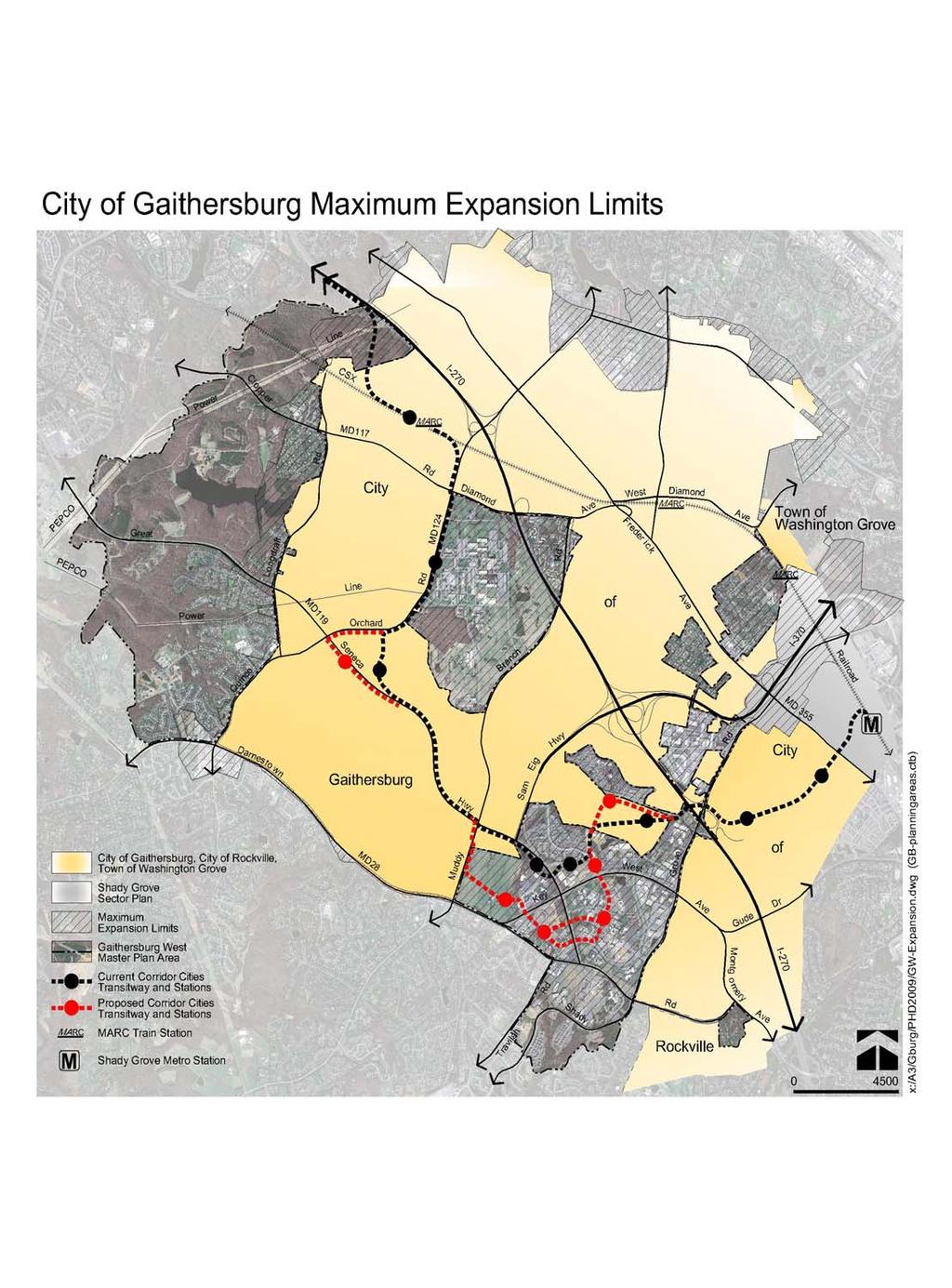
8 The Maryland Planning Act defined seven visions that are embraced and affirmed by this Plan: ) development is concentrated in suitable areas, ) sensitive areas are protected, ) in rural areas, growth is directed to existing population centers and resources are protected, ) stewardship of the Chesapeake Bay and the land is a universal ethic, ) resource conservation is practiced, including a reduction in resource consumption, ) economic growth is encouraged and regulatory mechanisms are streamlined to assure the achievement of one through five above, and ) funding mechanisms are addressed to achieve these visions. The Maryland Smart Growth Act supports growth in appropriate areas and limits development in agricultural and other resource areas by limiting State resources to existing communities and not subsidizing infrastructure in other areas. The Act encourages development principles designed to maximize existing infrastructure and focus investments in new infrastructure, including communities that are walkable and transit accessible. The policy s Priority Funding Areas concept includes criteria for counties to designate additional funding areas. The Montgomery County General Plan Refinement updated the goals and objectives of the General Plan. As discussed above, the General Plan affirmed the Wedges and Corridors concept as a framework for development in the County. The Plan divides Montgomery County into four geographic components: the Urban Ring, the Corridor, the Suburban Communities, and the Wedge. Each component is defined in terms of appropriate land uses, scale, intensity, and function. The Park, Recreation, and Open Space Plan explores future demand for recreational facilities within the County s,-acre park system and determines which natural and historic areas should be preserved as open space. The Countywide Park Trails Plan is a blueprint for creating a system of interconnected hard and natural surface trails in parkland. The Countywide Stream Protection Strategy is a comprehensive review of stream quality and habitat that helps public agencies identify and provide funding for specific watershed-based resource protection initiatives. The County s Legacy Open Space Functional Master Plan supports protection of natural and cultural resources through public acquisition and easements for properties that otherwise would not be protected through standard regulatory controls. The Plan identifies known resources and also defines a process for selecting sites, setting spending priorities, implementing the program and measuring its progress. The County Council s Transportation Policy Report recommended a vision and principles for future land use and transportation plans and described a recommended transportation network that will be reflected through the Master Plan of Highways and appropriate master plans. It also included an alternate Land Use Plan that improved the jobs and housing balance throughout Montgomery County to increase opportunities to live near employment centers. The County Council s Action Plan for Affordable Housing recommends using underdeveloped land near Metro stations for housing and encourages a full range of housing types to meet the diverse needs in the County. Annexations The cities of Gaithersburg and Rockville, which are adjacent to the Life Sciences Center, are directly affected by the Plan s recommendations. Two large, undeveloped parcels in Gaithersburg West are adjacent to the City of Gaithersburg the JHU Belward Campus and the Metropolitan Grove/McGown property and are within the City s maximum expansion limits. Maximum expansion limits (MEL) have been established by the municipalities as a guide to set a geographical boundary for potential future annexations of County land into the cities to allow for growth. Only land within the MEL can be considered for annexation and municipalities may only annex land that adjoins its boundaries.
9
10 A municipality may initiate annexations or property owners may petition a municipality to annex unincorporated territory. A valid petition requesting annexation does not compel its enactment. The municipal governing body alone is authorized to introduce and approve an annexation resolution. Annexations occur for a number of reasons, but the most obvious is economics. The City benefits because of the increased tax revenue. Property owners may benefit from increased flexibility in the potential development of a parcel, an enhanced identity, or improved services. The annotated Code of Maryland, Article A, Section, prescribes procedures for enlarging municipal boundaries in Maryland. The Code requires that municipalities produce a Municipal Growth Plan delineating the MEL. Municipalities may annex unincorporated land contiguous and adjoining the municipal boundaries if it is within the adopted MEL, but may not annex land within another municipality. An annexation cannot create an unincorporated enclave within the town or city that is surrounded on all sides by property within the municipality. According to state law, the Montgomery County Council must consent to any annexation where the land is placed by the City in a zone that allows a substantially different land use than that recommended by the current County master plan covering the property. The City may not place new zoning on annexed land that permits substantially different land uses from those specified in the County s zone for a period of five years after annexation, unless it has the consent of the Montgomery County Council. In, the City of Gaithersburg, the City of Rockville, and Montgomery County entered into a joint Memorandum of Understanding that established guidelines for land use and required community facilities, as well as the agreement by the jurisdictions to work cooperatively to develop procedural guidelines for annexation agreements that include staging components. The memorandum states it is essential that all jurisdictions support well-managed economic development and housing initiatives which will be mutually advantageous to all parties, and agree to the goals and principles of the General Plan. Over the years, the City of Gaithersburg has envisioned a series of annexations that would create corporate limits following logically defined boundaries such as roads and highways, rather than private property lines. Since, the City undertook a fairly aggressive annexation program that added over, acres to the municipality. Some of the larger annexed properties included IBM, the Washingtonian Center, Asbury Methodist Village, and National Geographic. The City of Gaithersburg currently covers, acres, or square miles. The City s goal of logical and clear boundaries may never come to fruition since many of the areas that would have to be annexed to create well-defined corporate limits are developed with existing and established uses that do not offer the potential for substantially increasing city tax revenues. A number of annexations have significantly altered boundaries adjacent to the municipalities. The following properties have been annexed into the City of Gaithersburg since the Master Plan: the Washingtonian Center, IBM, National Geographic Society, National Partnership, Washingtonian Industrial Park, Bechtel, Asbury Methodist Village, Teunis, Summit Hall Turf Farm, the Kramer property, the Carpenter property, and the Crown Farm. In addition, the Thomas Farm/Fallsgrove and King Farm were annexed into the City of Rockville. Several areas that were part of the and master plans are now covered by other plans, including the Shady Grove Metro Station area, which is the subject of the Shady Grove Sector Plan. Gaithersburg: The Science Capital of the United States Gaithersburg was primarily a farming community until the middle of the th century. With the opening of I- (originally S) in the s, the mid-county landscape began to transform from agrarian to residential and business development. At the same time, during the Cold War years, the federal government began to look to surrounding suburban bedroom communities to find locations for agency expansions, based on concerns over nuclear attacks in the heart of Washington, D.C. Abundant land, easily accessible by I-, made Gaithersburg an attractive location.
11 In, the federal government purchased two farms adjacent to I- for the headquarters of the National Bureau of Standards, now known as the National Institute of Standards and Technology (NIST). When NIST opened in, the City s Town Administrator, William Vose, predicted that Gaithersburg would become known as The Science Capital of the United States. For many years, NIST was the largest employer in Gaithersburg. Other major corporations soon began to locate in the area, including IBM, National Geographic, and the Communication Satellite Corporation. To support the employment, housing developments and shopping centers, as well as schools and other services were built. The origins of the Shady Grove Life Sciences Center are found in the Gaithersburg Vicinity Master Plan, which proposed a medical center complex near Shady Grove Road west of I-. The medical center complex was intended to provide a variety of public and private institutional uses, including a teaching hospital, medical research facility, and a full complement of health services for the rapidly growing western suburbs. In, Shady Grove Adventist Hospital opened among rolling pastures and farm fields. In, land northwest of the hospital was conveyed to the State for the Regional Institute for Children and Adolescents (RICA) and the Noyes Institute. In the early s, Montgomery County government made a strategic decision to use public resources to enhance its competitive position to attract the biotechnology industry. With land and location as its principle benefits, and the presence of a strong federally supported scientific community, biotechnology was a natural focus for the County s economic development program. Created on nearly acres of publicly-owned land, the LSC included three components medical services in the center, educational institutions to the north and south, and surrounding land available to attract research and development companies. Medical services were clustered around Shady Grove Adventist Hospital. To bring academic institutions to the area, the County donated acres north of the hospital to Johns Hopkins University (JHU-MCC) and acres south of Darnestown Road to the University of Maryland (for the Universities at Shady Grove, USG).
INTRODUCTION PLANNING HISTORY
 INTRODUCTION The Upper Rock Creek Master Plan Area lies in the east central part of Montgomery County. The Master Plan Area is adjacent to the City of Rockville to the south, the Olney Planning Area to
PSRC REVIEW REPORT & CERTIFICATION RECOMMENDATION
 PSRC REVIEW REPORT & CERTIFICATION RECOMMENDATION KITSAP COUNTY COUNTYWIDE PLANNING POLICIES July 2, 2012 BACKGROUND A major emphasis of the Washington State Growth Management Act (GMA) is the need to
Transit-Oriented Mixed Use Zoning in Montgomery County, Maryland
 Transit-Oriented Mixed Use Zoning in Montgomery County, Maryland Nkosi Yearwood Community-Based Planning Division Montgomery County Planning Department Rail Volution 2007 Miami, Florida The General Plan
THE 355/270 CORRIDOR:
 THE 355/270 CORRIDOR: Strategic Ideas for Sustaining a Livable Work Place Project Summary ACCESS LIFE DESIGN HEALTH WORK Montgomery County Planning Department The Maryland-National Capital Park and Planning
Status Report: MD 355 Project
 Status Report: MD 355 Project OCTOBER 2006 M-NCPPC MONTGOMERY COUNTY PLANNING DEPARTMENT Summary of Community Comments, and break to the Results of the MD 355 Participation Session Brookside Gardens -
master plan of highways bus rapid transit amendment
 Scope of Work master plan of highways bus rapid transit amendment September 2011 Montgomery County Planning Department M-NCPPC MontgomeryPlanning.org 1 Scope of Work master plan of highways bus rapid transit
This page intentionally blank.
 This page intentionally blank. Parks, Recreation, and Open Space Chapter Relationship to Vision Vision Parks, Recreation and Open Space Chapter Concepts County Government. County government that is accountable
Arlington, Virginia is a worldclass
 EXECUTIVE S U M M A RY Arlington maintains a rich variety of stable neighborhoods, quality schools and enlightened land use policies, and received the Environmental Protection Agency s highest award for
IMPLEMENTING SOMERSET COUNTY S INVESTMENT FRAMEWORK
 IMPLEMENTING SOMERSET COUNTY S INVESTMENT FRAMEWORK SMART CONSERVATION THROUGH SMART GROWTH NJ LAND CONSERVATION RALLY March 22, 2014 Laurette Kratina, PP, AICP, Supervising Planner Somerset County Planning
2040 LUP is a part of the Comprehensive Plan and carries the same legal authority. Economic Challenges
 1.1. Guiding Anchorage s Growth Where will new residents settle over the next two decades? Where will people work, shop, and play? Will there be enough room to grow? How will Anchorage look? Will growth
Growth Management Planning in the Central Puget Sound Region. Today s Presentation. Puget Sound Region. New Partners for Smart Growth
 Growth Management Planning in the Central Puget Sound Region New Partners for Smart Growth Denver, CO January 2006 Today s Presentation Regional growth management in central Puget Sound, WA Regional geographies
SECTION ONE: INTRODUCTION. introduction
 introduction 1 INTRODUCTION Since it was first established in 1843 as a trading post for the Hudson s Bay Company, Victoria has evolved into a Provincial capital city that is recognized across Canada and
Concord Community Reuse Project Goals and Guiding Principles. Overarching Goals (OG)
") Concord Community Reuse Project Goals and Guiding Principles Overarching Goals (OG) No priority is implied by the order of presentation of the goals and guiding principles. Overarching goals for the Concord
Concord Community Reuse Project Goals and Guiding Principles Overarching Goals (OG) No priority is implied by the order of presentation of the goals and guiding principles. Overarching goals for the Concord
Joint Public Hearing. Preliminary Subregion 5 Master Plan and Proposed Sectional Map Amendment
 Preliminary Subregion 5 Master Plan and Proposed Sectional Map Amendment Joint Public Hearing April 11, 2013 Council Hearing Room Upper Marlboro 7:00 pm His Lordship s Kindness (Clinton) Presentation Overview
ANC 2A Presentation. November 9, 2006
 ANC 2A Presentation November 9, 2006 Introduction & Overview Applicants Boston Properties and KSI Services (project developers) The George Washington University (land owner) 2.66 acre site (former GW hospital
CITY OF COLWICH COMPREHENSIVE PLAN LAND USE LAND USE 1
 LAND USE LAND USE 1 WHAT YOU WILL FIND IN THIS CHAPTER: Discussion of today s conditions and tomorrow s projections Discussion of challenges and opportunities Discussion of the environmental quality goals,
Corridor Vision. 1Pursue Minnehaha-Hiawatha Community Works Project. Mission of Hennepin County Community Works Program
 1Pursue Minnehaha-Hiawatha Community Works Project Minnehaha-Hiawatha Community Works is a project within the Hennepin Community Works (HCW) program. The mission of the HCW program is to enhance how the
Vision & Land Use. Discussion. Historic Preservation Plan. Foggy Bottom Campus Plan:
 Vision & Land Use Foggy Bottom Campus Plan: 2006-2025 Historic Preservation Plan Discussion Community Meeting Presentation August 2, 2006 Presentation Format Overview Sherry Rutherford, GW Foggy Bottom
Chapter 2: Vision, Goals and Strategies
 Chapter 2: Vision, Goals and Lake Elmo Today & Tomorrow Comprehensive Plan 2040 2 VISION, GOALS & STRATEGIES - DRAFT 4-6-2018 INTRODUCTION Comprehensive Plan Purpose Perhapse the most important objective
S C O P E O F W O R K A P R I L
 white flint 2 sector plan S C O P E O F W O R K A P R I L 2 0 1 2 MONTGOMERY COUNTY PLANNING DEPARTMENT M-NCPPC MontgomeryPlanning.org 1 white flint 2 sector plan Scope of Work abstract This scope of work
7Page 1 CLEMMONS COMMUNITY COMPASS 1 PLAN OVERVIEW
 1 Plan Overview WHAT IS I THE CLEMMONS COMMUNITY COMPASS? The Clemmons Community Compass is our community s comprehensive plan. It serves as our blueprint and provides direction for the future of the Village
CHAPTER 12 IMPLEMENTATION
 CHAPTER 12 IMPLEMENTATION The 2010 Town of Denton Comprehensive Plan is intended to capture a vision of the future of Denton. As such, it provides a basis for a wide variety of public and private actions
Municipal Development Plan 2013
 UNIQUELY STONY PLAIN: Municipal Development Plan 2013 Quick Reference Guide What is a Municipal Development Plan (MDP)? The Town s highest-level planning document Sets the long-term vision and key themes
Chapter IV: Development Pattern
 Chapter IV: Development Pattern Introduction The 2002 Prince George s County Approved General Plan designates three growth policy tiers Developed, Developing, and Rural as well as three center designations
TEMPLE MEDICAL & EDUCATION DISTRICT
 City of Temple, Texas TEMPLE MEDICAL & EDUCATION DISTRICT 1 Description. The City of Temple joined in partnership with key public and private entities to jointly promote education and medical activities
JANUARY 19, 2011 CENTRAL AVENUE-METRO BLUE LINE TRANSIT-ORIENTED DEVELOPMENT IMPLEMENTATION PROJECT COMMUNITY FORUM
 CENTRAL AVENUE-METRO BLUE LINE TRANSIT-ORIENTED DEVELOPMENT IMPLEMENTATION PROJECT COMMUNITY FORUM JANUARY 19, 2011 THE MARYLAND-NATIONAL CAPITAL PARK AND PLANNING COMMISSION PRINCE GEORGE S COUNTY PLANNING
Visioning Statement and Guiding Principles
 Visioning Statement and Guiding Principles Planning for the Future The General Plan The General Plan represents Woodland's shared vision of the future and defines a path to lead the community toward its
S A C R A M E N T O C O U N T Y JACKSON HIGHWAY & GRANT LINE EAST VISIONING STUDY
 JACKSON HIGHWAY & GRANT LINE EAST S A C R A M E N T O C O U N T Y P L A N N I N G D E P A R T M E N T SUMMARY AND WORKBOOK November 19, 2008 History of the Visioning Study Sacramento County has two growth
Town of Peru Comprehensive Plan Executive Summary
 Town of Peru Comprehensive Plan Executive Communities that plan grow by choice, not by chance. A plan makes growth thoughtful, understandable, and predictable. A plan shows that a community is managing
Planning the Corridor Cities Transitway in Montgomery County Maryland
 Planning the Corridor Cities Transitway in Montgomery County Maryland Kyle Nembhard Parsons Brinckerhoff Baltimore, MD Introduction Many transit projects involve an area that is mostly developed or has
CHAPTER 1. Ms. Guajardo s Class - Central Elementary CH 1 1
 INTRODUCTION CHAPTER 1 Ms. Guajardo s Class - Central Elementary CH 1 1 1.1 SETTING South Centre City is a linear corridor south of Downtown Escondido paralleling Centre City Parkway and South Escondido
TOD 101 CREATING LIVABLE COMMUNITIES WITH TRANSIT
 1 CREATING LIVABLE COMMUNITIES WITH TRANSIT What are transit Centered Communities? Benefits of Partnerships to Support and Implement What You Will Learn Portland s Pearl District Your Trainers Today Catherine
This chapter describes the purpose of the Plan, introduces how the Plan is organized and provides contextual background for the Plan.
 Chapter 1: INTRODUCTION Purpose of a Comprehensive Plan The 2040 Comprehensive Plan establishes Medina s vision as a community and sets goals and objectives which guide future decisions and policies. The
1 Introduction. Chapter. In this chapter:
 Chapter 1 Introduction In this chapter: 1.1 A Snapshot of the Region 1.2 Towards a Sustainable Region 1.3 The Provincial Context 1.4 Purpose and Organization The Regional Municipality of York Official
13 THORNHILL YONGE STREET STUDY IMPLEMENTATION CITY OF VAUGHAN OPA 669 AND TOWN OF MARKHAM OPA 154
 13 THORNHILL YONGE STREET STUDY IMPLEMENTATION CITY OF VAUGHAN OPA 669 AND TOWN OF MARKHAM OPA 154 The Planning and Economic Development Committee recommends the adoption of the recommendations contained
Seneca Meadows. Block 4 Locate office, technology, and medical development adjacent to I Screen views of garage structures from I-270.
 Seneca Meadows Seneca Meadows has an industrial park in its southern end and a mixed-use employment area planned for the north end. The district benefits from extensive I-270 visibility, stream valley
Potential Annexation Areas And Annexation
 Exhibit A to Ordinance No. - Proposed Amendments to the Pierce County Countywide Planning Policies Addressing Potential Annexation Areas And Annexation 1 0 1 0 1 COUNTYWIDE PLANNING POLICY ON URBAN GROWTH
MEMORANDUM AGENDA ITEM #6c
 South Florida Regional Planning Council MEMORANDUM AGENDA ITEM #6c DATE: FEBRUARY 1, 2010 TO: FROM: SUBJECT: COUNCIL MEMBERS STAFF CITY OF PARKLAND PROPOSED COMPREHENSIVE PLAN AMENDMENT (ALTERNATIVE REVIEW)
Comprehensive Plan ADOPTED APRIL 2014
 Comprehensive Plan ADOPTED APRIL 2014 8 8. Outstanding Recreational & Cultural Opportunities We are proud of our community s parks and recreation system. Our community will ensure that the legacy of our
Prepared for the Citizens of Forsyth County by the City-County Planning Board
 Prepared for the Citizens of Forsyth County by the City-County Planning Board Bryce A. Stuart Municipal Building 100 East First Street, Winston-Salem, NC 27101 336.727.8000 www.cityofws.org/planning www.legacy2030.com
Regional Context Statement
 Regional Context Statement REGIONAL CONTEXT STATEMENT 3. REGIONAL CONTEXT STATEMENT In 1995, the Provincial Government passed into law the Growth Strategies Act. The purpose of this provincial initiative
Plan Overview. Manhattan Area 2035 Reflections and Progress. Chapter 1: Introduction. Background
 Plan Overview The Manhattan Urban Area Comprehensive Plan (the Comprehensive Plan) is a joint planning initiative of the City of Manhattan, Pottawatomie County, and Riley County. The 2014 Comprehensive
Urban Planning and Land Use
 Urban Planning and Land Use 701 North 7 th Street, Room 423 Phone: (913) 573-5750 Kansas City, Kansas 66101 Fax: (913) 573-5796 Email: planninginfo@wycokck.org www.wycokck.org/planning To: From: City Planning
HELPING SMALL TOWNS AND RURAL AREAS THRIVE
 EPA Office of Sustainable Communities HELPING SMALL TOWNS AND RURAL AREAS THRIVE Village of Vinton, Texas May 30, 2013 Katharine Ange, AICP Renaissance Planning Group Overview of Workshop Discussion of
COUNTY-WIDE PLANNING POLICIES
 Thurston County COUNTY-WIDE PLANNING POLICIES November 10, 2015 These policies were adopted by the Board of County Commissioners on September 8, 1992. They were ratified earlier by each of the seven cities
City Center Neighborhood Plan
 [1] City Center Neighborhood Plan As adopted by Ordinance No. 2014-09-049 and amended by Ordinance Nos. Formerly CBD Neighborhood as adopted by Ordinance No. 8868 and amended by Ordinance Nos. 8946, 9693,
CHAPTER 7: Transportation, Mobility and Circulation
 AGLE AREA COMMUNITY Plan CHAPTER 7 CHAPTER 7: Transportation, Mobility and Circulation Transportation, Mobility and Circulation The purpose of the Transportation, Mobility and Circulation Chapter is to
3.0 PROJECT DESCRIPTION
 3.0 PROJECT DESCRIPTION 3.1 BACKGROUND Under California law (Government Code Section 65300 et seq.), every city and county is required to have a general plan. The general plan is to be comprehensive and
EXHIBIT A. Tax Increment Reinvestment Zone No. 1 (Town Center) First Amended Project Plan 1
 First Amended Project Plan 1") EXHIBIT A Tax Increment Reinvestment Zone No. 1 (Town Center) First Amended Project Plan 1 1 As amended by Resolution No. 2008-02-001(TR1R) of the Tax Increment Reinvestment Zone No.1, and approved to
EXHIBIT A Tax Increment Reinvestment Zone No. 1 (Town Center) First Amended Project Plan 1 1 As amended by Resolution No. 2008-02-001(TR1R) of the Tax Increment Reinvestment Zone No.1, and approved to
3. Endorse the LRT vision in transforming Surrey into Connected-Complete-Livable communities, and more specifically, the official vision statement:
 CORPORATE REPORT NO: R038 COUNCIL DATE: February 20, 2017 REGULAR COUNCIL TO: Mayor & Council DATE: February 16, 2017 FROM: General Manager, Engineering FILE: 8740-01 SUBJECT: Surrey Light Rail Transit
Prepared by: The Maryland-National Capital Park and Planning Commission. Approved by: The Montgomery County Council January 17, 2006
 Prepared by: The Maryland-National Capital Park and Planning Commission Approved by: The Montgomery County Council January 17, 2006 Adopted by: The Maryland-National Capital Park and Planning Commission
CHAPTER 2: PLANNING PRINCIPLES
 CHAPTER 2: PLANNING PRINCIPLES 2 Comprehensive Principles The following overarching Principles provide the basis for the goals and policies included in the Mendocino County General Plan. These Principles
GENERAL PLAN UPDATE ISSUES MEETING. January 21, 2010 City Hall Mitchell Room 6:00 pm 9:00 pm
 GENERAL PLAN UPDATE ISSUES MEETING January 21, 2010 City Hall Mitchell Room 6:00 pm 9:00 pm WELCOME! Introductory Comments Continued Review of Quality of Life Standards, Growth Management, Proposition
SALISBURY TOMORROW Our Vision
 SALISBURY TOMORROW Our Vision Salisbury is committed to supporting a high quality of life and sense of community for all residents. These commitments need to be reflected in our community programs, services
Branch Avenue Corridor
 Approved Branch Avenue Corridor Sector Plan Prince George s County Planning Department The Maryland-National Capital Park and Planning Commission September 2008 Abstract TITLE: AUTHOR: SUBJECT: The Maryland-National
Official Plan Review
 Official Plan Review Summary Report - The Built Environment August 2014 Part 1: Introduction Planning for a healthy, prosperous and sustainable community is an important goal for our municipality. From
Preliminary Recommendations Tk Takoma/Langley Crossroads Sector Plan
 Preliminary Recommendations Tk Takoma/Langley Crossroads Sector Plan Vision is to achieve a Transit Oriented, pedestrian friendly Community that Celebrates and builds upon the cultural Diversity of the
2010 Plan of Conservation and Development
 2010 Plan of Conservation and Development Wilton Planning and Zoning Commission Adopted November 2, 2009 Effective January 1, 2010 WILTON 2010 PLAN OF CONSERVATION & DEVELOPMENT PARTICIPANTS Planning &
Implementation Guide Comprehensive Plan City of Allen
 Implementation Guide 2030 Comprehensive Plan City of Allen DRAFT 2015 Implementation Guide Allen 2030 Comprehensive Plan INTRODUCTION The Comprehensive Plan serves as a guide for the growth and development
Protecting Farmland. The Future of Agriculture in Prince George s County
 Protecting Farmland As demonstrated in the previous section, farmland in Prince George s County is disappearing at a rapid pace. If the loss of farmland continues at this rate, no farmland will be left
Executive Summary. Parks and Recreation Plan. Executive Summary
 Parks and Recreation Plan Executive Summary The Whitemarsh Township Parks and Recreation Plan sets forth a vision for how Whitemarsh Township can provide a premiere parks and recreation system reflective
A community driven catalyst for an equitable, healthy, (economically viable and environmentally) sustainable corridor
 sustainable corridor") Economy Environment Equity Building Sustainability Supporting neighborhoods Preserving municipal resources A community driven catalyst for an equitable, healthy, (economically viable and environmentally)
Economy Environment Equity Building Sustainability Supporting neighborhoods Preserving municipal resources A community driven catalyst for an equitable, healthy, (economically viable and environmentally)
January Guiding the Future of the MD 355/I-270 Corridor
 January 2008 Guiding the Future of the MD 355/I-270 Corridor GUIDING THE FUTURE OF THE MD 355/I-270 CORRIDOR January 2008 The Montgomery County Planning Department MD 355/I-270 Project 1 January 2008 MD
iii. Visioning framework
 III. VISION iii. Visioning framework III.1 Overview A vision is a clear and succinct description of what an institution and its community should look like after it successfully implements its goals and
Robbinsdale LRT Station. CDI Development Guidelines. August Overview
 Robbinsdale LRT Station August 2018 Overview The City of Robbinsdale may have the coolest opportunity site along the 13 mile stretch of the Bottineau LRT corridor / Blue Line extension. Located a block
white flint 2 sector plan
 white flint 2 sector plan Public Hearing Draft NOVEMBER 2016 MONTGOMERY COUNTY PLANNING DEPARTMENT M-NCPPC MontgomeryPlanning.org White Flint 2 Sector Plan Public Hearing Draft Abstract This Plan contains
LAND USE OVERVIEW WHAT YOU WILL FIND IN THIS CHAPTER
 LAND USE WHAT YOU WILL FIND IN THIS CHAPTER Information about the City s expected population and employment growth. Description and capacity of existing and future land use designations. Policies that
D-O LRT Zoning Discussion. Chapel Hill Boards & Commissions October 16, 2017
 D-O LRT Zoning Discussion Chapel Hill Boards & Commissions October 16, 2017 Update on Overall D-O LRT Station Area Initiative Objectives Design and educate on principles of Good Transit-Oriented Development
City of Tacoma Planning and Development Services
 Agenda Item D-1 City of Tacoma Planning and Development Services To: Planning Commission From: Elliott Barnett, Planning Services Division Subject: Application #2014-08 Open Space Element Update Meeting
Town Center (part of the Comprehensive Plan)
") Town Center (part of the Comprehensive Plan) Mercer Island Town Center Looking North (2014) In 1994, a year-long process culminated in a set of design guidelines and code requirements for the Town Center
Town Center (part of the Comprehensive Plan) Mercer Island Town Center Looking North (2014) In 1994, a year-long process culminated in a set of design guidelines and code requirements for the Town Center
Plano Tomorrow Vision and Policies
 Plano Tomorrow Vision and Policies PLANO TOMORROW PILLARS The Built Environment The Social Environment The Natural Environment The Economic Environment Land Use and Urban Design Transportation Housing
DRAFT Amsterdam/Churchill Community Plan (4/17/08) Adopted By the Gallatin County Commission
 Adopted By the Gallatin County Commission") DRAFT Amsterdam/Churchill Community Plan (4/17/08) Adopted By the Gallatin County Commission Table of Contents Acknowledgements Chapter 1: Introduction A Brief History What s Next Authority Organization
DRAFT Amsterdam/Churchill Community Plan (4/17/08) Adopted By the Gallatin County Commission Table of Contents Acknowledgements Chapter 1: Introduction A Brief History What s Next Authority Organization
The transportation system in a community is an
 7 TRANSPORTATION The transportation system in a community is an important factor contributing to the quality of life of the residents. Without a sound transportation system to bring both goods and patrons
OVERVIEW OF PLANS FOR THE JEFFERSON COUNTY COUNTRYSIDE FARM In the Context of Quality Place Characteristics
 OVERVIEW OF PLANS FOR THE JEFFERSON COUNTY COUNTRYSIDE FARM In the Context of Quality Place Characteristics By Steve Grabow, Professor and Community Development Educator University of Wisconsin-Extension,
FROM METRO STATIONS TO GREAT URBAN PLACES
 FROM METRO STATIONS TO GREAT URBAN PLACES New Downtowns for Prince George s County 2016 Rail~Volution Conference San Francisco CA BRIEF HISTORY OF WASHINGTON METRO SYSTEM Washington regional Metro System
Chapter 1 Vision Statement & Goals
 Chapter 1 Section 1.1 Section 1.2 Section 1.3 Section 1.4 Section 1.5 Introduction Vision Statement Visioning Exercise Prioritization of Land Use Issues Goals of the Comprehensive Plan CHAPTER 1 SECTION
Economy Vision Statements: Social Wellbeing Vision Statements: Natural Environment Vision Statements:
 Economy Vision Statements: 1. Our business environment makes us a region of choice for new employers as we encourage entrepreneurship and have a vibrant, diversified and resilient regional economy. 2.
IMPLEMENTATION STRATEGIES. In This Chapter. Goals & Strategies 182 Project List 183 Future Land Use 186 CHAPTER 11 IMPLEMENTATION STRATEGIES
 In This Chapter Goals & Strategies 182 Project List 183 Future Land Use 186 11 IMPLEMENTATION STRATEGIES NORTH AUGUSTA, SC 2017 COMPREHENSIVE PLAN 179 Individual commitment to a group effort that is what
From Growth Controls, to Comprehensive Planning, to Smart Growth: Planning s Emerging Fourth Wave
 From Growth Controls, to Comprehensive Planning, to Smart Growth: Planning s Emerging Fourth Wave Dr. Tim Chapin Department of Urban & Regional Planning Florida State University Presentation at the APA
EXISTING COMPREHENSIVE PLAN
 EXISTING COMPREHENSIVE PLAN Town Center Land Use Element: V. LAND USE POLICIES Town Center Mercer Island's business district vision as described in "Your Mercer Island Citizen-Designed Downtown" was an
EXECUTIVE SUMMARY DRAFT CHAPTER 1 INTRODUCTION EXECUTIVE SUMMARY
 CHAPTER 1 EXECUTIVE SUMMARY INTRODUCTION Through the joint efforts of the City of Tulsa planning staff and the Land Services division of Indian Nations Council of Governments (INCOG), the Berryhill Land
TO: Mayor & Council DATE: April 12, The Planning and Development Department and the Engineering Department recommend that Council:
 CORPORATE REPORT NO: R080 COUNCIL DATE: April 12, 2010 REGULAR COUNCIL TO: Mayor & Council DATE: April 12, 2010 FROM: SUBJECT: General Manager, Planning and Development General Manager, Engineering Neighbourhood
Goal 14 Urbanization
 Urbanization The residents of Benton County value the rural character that still exists in much of the County, the distinction that has been maintained between settlement areas and resource lands and open
CITY OF PUYALLUP. Background. Development Services
 CITY OF PUYALLUP Development Services 333 South Meridian Puyallup WA 98371 To: City Council From: Katie Baker, AICP, Planning Division Re: South Hill Neighborhood Plan Adoption Date: (Meeting date: February
Outlawing Sprawl. Pennsylvania Chapter American Planning Association October 6, 2009
 Outlawing Sprawl Pennsylvania Chapter American Planning Association October 6, 2009 Presented by: Ronald T. Bailey, AICP Executive Director Chester County Planning Commission Location: 2009 PA Chapter
LAND USE ELEMENT. Purpose. General Goals & Policies
 LAND USE ELEMENT Purpose This Land Use Element contains the goals and policies necessary to support the City s responsibility for managing land resources and guiding development through implementing regulations,
EXECUTIVE SUMMARY EXECUTIVE SUMMARY
 1 EXECUTIVE SUMMARY EXECUTIVE SUMMARY Penn s Landing is envisioned as a welcoming riverfront green space adjacent to a refurbished civic marina becoming the centerpiece for adjacent development. With a
9 CITY OF VAUGHAN OFFICIAL PLAN AMENDMENT NO BOCA EAST INVESTMENTS LIMITED
 9 CITY OF VAUGHAN OFFICIAL PLAN AMENDMENT NO. 631 - BOCA EAST INVESTMENTS LIMITED The Planning and Economic Development Committee recommends the adoption of the recommendations contained in the following
The Corporation of the Town of Milton
 Report To: From: Council Barbara Koopmans, Commissioner, Planning and Development Date: May 7, 2018 Report No: Subject: Making it Possible Positioning the Town s Strategy for Growth and Economic Development
Transforming Saint John s Urban Heart -
 Transforming Saint John s Urban Heart - How Innovative Community Engagement Inspires a Bold Municipal Plan for a More Sustainable and Compact Saint John 2012 NNECAPA Conference - Brunswick, ME October
Rural Land Use Designations Kittitas County December 6, 2007 Draft
 KITTITAS COUNTY COMMUNITY DEVELOPMENT SERVICES 411 N. Ruby St., Suite 2, Ellensburg, WA 98926 CDS@CO.KITTITAS.WA.US Office (509) 962-7506 Fax (509) 962-7682 Rural Land Use Designations Kittitas County
Chapter 10 IMPLEMENTATION RECOMMENDATIONS
 Chapter 10 IMPLEMENTATION RECOMMENDATIONS The recommended land use plan presented in the previous chapter provides a design for the attainment of the urban and rural development and open space preservation
Proposed Comprehensive Plan Strategies DRAFT for discussion June 28, 2017
 Proposed Comprehensive Plan Strategies DRAFT for discussion June 28, 2017 Land Use Rural Areas Refine the Farm and Forest area (FF) Update FF boundaries to account for existing lots less than five acres
Foreword. Sincerely, Elizabeth M. Hewlett. Approved Sector Plan and Sectional Map Amendment for the Tuxedo Road/Arbor Street/Cheverly Metro Area
 Foreword The Prince George s County Planning Board of The Maryland-National Capital Park and Planning Commission (M-NCPPC) is pleased to make available the Approved Sector Plan and Sectional Map Amendment
CONTENTS 2.0 A FRAMEWORK FOR SUSTAINABLE GROWTH 2.1 MANAGING SUSTAINABLE GROWTH THE VISION TO GOALS AND OBJECTIVES 2.3 MARKHAM STRUCTURE
 2 A Framework for Sustainable Growth 2.0 A FRAMEWORK FOR SUSTAINABLE GROWTH CONTENTS 2.1 MANAGING SUSTAINABLE GROWTH THE VISION TO 2031 2.2 GOALS AND OBJECTIVES 2.2.1 Protecting the Natural Environment
Land Use & Transportation Primer
 Land Use & Transportation Primer Presented By Smitha Vijayan Center for Urban Transportation Studies University of Wisconsin-Milwaukee Role of Local Government Land use decision-making power mostly given
Benchmark Nonpoint Source Management Approaches In Other States
 Governor s Environmental Advisory Council 2007 Nonpoint Source Pollution Control Initiative Benchmark Nonpoint Source Management Approaches In Other States Governor s Environmental Advisory Council April
Town of Cobourg Heritage Master Plan. Statutory Public Meeting
 Town of Cobourg Heritage Master Plan Statutory Public Meeting April 25 th 2016 Presentation Overview 1. Introduction 2. Project background and schedule overview 3. Review of strategic direction content
ROBBINSDALE LRT STATION CDI DEVELOPMENT GUIDELINES
 August 2018 OVERVIEW The City of Robbinsdale has a prime-opportunity site in the middle of the 13 mile stretch of the Bottineau LRT corridor / Blue Line extension. Robbinsdale offers a prominent, vital,
Official Plan Review: Draft Built Form Policies
 PG.30.1 REPORT FOR ACTION Official Plan Review: Draft Built Form Policies Date: May 15, 2018 To: Planning and Growth Management Committee From: Chief Planner and Executive Director, City Planning Division