PART 05 VISUAL SETTING
|
|
|
- Abner Robertson
- 5 years ago
- Views:
Transcription

1 PART 05 VISUAL SETTING 5.1 How to use the Visual Settings 5.2 Views from the Headland 5.3 Creek Foreshore Park Looking North 5.4 Bridge looking North 5.5 Bridge looking West 5.6 Bridge looking South 5.7 Creek Street 5.8 Southern Entry 5.9 Northern Entry 5.10 Young Street 157

2 PART 05 - VISUAL SETTINGS 158


3 PART 05 - VISUAL SETTINGS STEP 01 : Check what precinct your development site falls under. STEP 02 : Check what view fields have been nominated within that precinct. STEP 03 : Determine if your proposed development will project into the nominated view field. STEP 04 : If your development projects into the nominated view field, prepare contextual photomontage illustrating relationship between proposal and visual setting for determination. Note that the defined view field box is not indicative of allowable building envelope within that view field. STEP 05 : Further height justification, including the erection of height poles during a development applications advertised period may be required to determine building height, scale and building form impacts on visual settings. 5.1 How to Use the Visual Settings The maintenance of prominent viewfields within the Hastings Point locality is a key consideration for all future developments in the locality. Figure 3.5 identifies the lots potentially affected by the visual settings controls and should be used with the Views for Photomontage and Control Diagrams by applicants throughout the design and assessment process. The Views for Photomontage are provided within each identified visual setting to assist in the preparation of design proposals, Development Applications and public domain plans. A Control Diagram for each visual setting has been provided to assist the design process and to aid in determining the acceptable level of change to each visual setting. Major elements within a view have been identified in a Control Diagram; for example, the line of the horizon against the sky, the foreshore or the water and what must be retained as documented under each visual setting. Minor elements within the view have not been identified and changes to these elements may be considered where the changes proposed are in keeping with the visual setting as identified. In some cases an indication of improvements to a visual setting have been provided that will assist in strengthening Hastings Point as a small coastal settlement encased within a natural environment. Refer also to Part Scenic protection and views. Bounding boxes identify view field only and are not indicative of allowable building envelope within defined view fields. Figure 5.0 View Field Descriptive Diagram - The white boxes do not indicate that a building can fill the entire box, but identifies that future development needs to be contained within it. This needs to be read in conjunction with other development controls including building height, setback, building form, materials and landscaping requirements. 159

4 PART 05 - VISUAL SETTINGS - HEADLAND 5.2 Views from the Headland This visual setting is taken looking north, south and east from the headland road. It is the most recognisable view of Hastings Point. It is enjoyed by many people throughout the year and on a daily basis. This is a primary view as it takes in an overview of the settlement. It is also an important view as it provides an understanding of the settlement as a small collection of buildings nestled within nature. Figure View field from the headland Key Indicative area of visual Setting Lots potentially affected by visual setting Looking to the west and south the dunes are close up within the view and relatively tall and obscure buildings within the southern part of the settlement. Of key importance is the view to the north as this contains a view of the settlement. A Mid-layer between foreshore vegetation and the hills behind where it is acceptable that buildings are visible. Figure 5.2 Control Diagram - Viewfield from the headland Figure 5.3 View for Photomontage - from the headland 160

 ie. buildings do not meet water, sand or sky. Objectives i.")
5 PART 05 - VISUAL SETTINGS - HEADLAND Key Characteristics The layering of vegetation on the headland, water and sand, foreshore vegetation (on the northern side of the creek) and finally the hills in the distance which meet the sky. Buildings are seen nestled between the foreshore vegetation and the hills in the distance. The view shows how the settlement is surrounded and contained by vegetation; buildings are nestled within nature, with nature dominating built form. Vegetation meets water, sand and sky. Buildings are contained within and surrounded by vegetation (top, bottom and to both sides) ie. buildings do not meet water, sand or sky. Objectives i. Retain the sequence of layers from headland vegetation to sky; vegetation on the headland, water and sand, foreshore vegetation (on the northern side of the creek) and the hills in the distance which meet the sky. ii. Buildings are a component of the visual setting and sit between the foreshore vegetation layer and the hills in the distance layer. Controls 1. Development applications for lots within the visual setting must be accompanied by a photomontage demonstrating impacts and measures to mitigate impacts. 2. Structures on lots within the visual setting may be visible on the mid layer, between the foreshore vegetation layer. 3. Public domain improvements such as picnic shelters, signage, fencing, facilities blocks or the like are not to be located within the visual setting. Sky Distant Hills layer Mid-layer Foreshore vegetation layer Water/sand Headland Vegetation 161

6 PART 05 - VISUAL SETTINGS - BEACH PARK LOOKING NORTH 5.3 Creek Foreshore Park Looking North This view is taken from within the park standing on the side of Tweed Coast Road opposite the shops, it is a wide view that takes in lots along the Tweed Coast Road, the shops, the caravan park and the estuary. The Creek Foreshore Park is Hastings Point s primary public space, making the qualities of this visual setting important. To the north-west the caravan park is visible and buildings on the southern end of Peninsula Street are also visible. Figure Viewfield from the Creek Foreshore Park looking north and west Key Indicative area of visual Setting Lots potentially affected by visual setting Key characteristics The layering of grass reserve, sand, water, sand and natural vegetation which meets the sky. The view is essentially natural to the east and north. Roofs of houses along Peninsula Street rise just above the vegetation line. To the west low and open structure within the caravan park, and road dominate the view but sit under the line of the hills on the western side of Christies and Cudgera Creeks and visible in the distance. Close up view of the shop and houses along the Tweed Coast Road. Buildings will be visible against the sky in the section of the view. Buildings are seen against the sky Streetscape and front setback vegetation, buildings Lower-layer; Park and road Figure 5.5 Control Diagram - Viewfield from the Creek Foreshore Park looking north Figure 5.6 View for Photomontage - from the Creek Foreshore Park looking north 162


7 PART 05 - VISUAL SETTINGS - BEACH PARK LOOKING NORTH Objectives i. Retain the natural qualities of the view to the north and east. ii. Retain the dominance of the hills against the sky to the west. iii. Continue to see building to the south and south-west. Controls Screen buildings; foreshore to be revegetated. 1. Development applications for lots within the visual setting must be accompanied by a photomontage demonstrating impacts and measures to mitigate impacts. 2. Replant foreshore vegetation along the creek to screen the base of buildings to the north. 3. Structures on lots within the visual setting may be visible on the mid-layer, between the foreshore vegetation layer. 4. Along the Tweed Coast Road buildings can break the treeline. 5. It is permissible to see one storey structures, caravans and tents within the view within the mid-layer but they cannot break into the upper layer. 6. Wherever possible public domain improvements such as picnic shelters, signage, fencing, facilities blocks or the like are not to be located within the visual setting. Mid-layer within which caravans and tents will be visible but not extend into the upper layer Upper-layer; hills and sky Mid-layer; foreshore vegetation, caravans Lower-layer; park and water 163

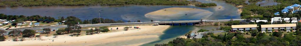
8 PART 05 - VISUAL SETTINGS - BRIDGE LOOKING NORTH 5.4 Bridge Looking North This view is taken looking north standing at the centre of the bridge. It takes in the bridge, buildings along Peninsula Street as well as the estuary, its sandy edges and the foreshore dunes. Figure Viewfield from the bridge looking north Key Indicative area of visual Setting Lots potentially affected by visual setting B It is acceptable that buildings are seen just below the horizon C To be revegetated along foreshore A It is acceptable that buildings are seen against the sky on the horizon. Figure 5.8 Control Diagram - Viewfield from the bridge looking north Figure 5.9 View for Photomontage - from the bridge looking north 164

9 PART 05 - VISUAL SETTINGS - BRIDGE LOOKING NORTH Key Characteristics A close up view of buildings along Peninsula Street and the boat shed on the foreshore. Built form is surrounded by natural vegetation around its base. The bridge is a dominant element within the view. Objectives i. Retain the composition of buildings against the sky and foreshore vegetation. Controls 1. Development applications for lots within the visual setting must be accompanied by a photomontage demonstrating impacts and measures to mitigate impacts. 2. Replant foreshore vegetation along the creek to screen the base of buildings. 3. Built form in proximity to the bridge can be visible against the sky; Refer to A in the Control Diagram, and just below the horizon; refer to B in the Control Diagram. 4. Vegetation along the foreshore must be retained on private lots and revegetated; refer to C in the Control Diagram. 165

10 PART 05 - VISUAL SETTINGS - BRIDGE LOOKING WEST 5.5 Bridge Looking West This view is taken looking west standing at the centre of the bridge. It takes in the waterways of both Cudgera and Christies Creeks, the creek s foreshore and the hills in the distance. Currently there is little built form within the majority of the view. Buildings are visible at the northern edge of the bridge. Foreshore vegetation screens the base of building. Figure 5.10 Viewfield from the bridge looking west Key Indicative area of visual Setting Lots potentially affected by visual setting Sky Upper-layer Mid-layer Lower-layer Water Figure 5.11 Control Diagram - Viewfield from the bridge looking west Figure 5.12 View for photomontage - from the bridge looking west 166

11 PART 05 - VISUAL SETTINGS - BRIDGE LOOKING WEST Key Characteristics The layering of water, foreshore vegetation, and the hills in the distance which meet the sky. The view is predominantly natural. There are few man-made elements within this view except buildings on the northern end of the bridge. Objectives i. Retain the predominance of nature within the view. ii. Carefully locate buildings so as to be nestled within the landscape. Controls 1. Development applications for lots within the visual setting must be accompanied by a photomontage demonstrating impacts and measures to mitigate impacts. 2. Built form visible in proximity to the bridge to the north can be made up of roofs and one level popping up between vegetation and above the horizon within the Midlayer and Upper-layer; refer to A in the Control Diagram. 3. Vegetation along the foreshore must be retained so that within the Lower-layer and Upper-layer only vegetation is visible. Built elements of any type within this layer are not acceptable. This will require the foreshore buffer to have an appropriate depth and buildings to be low enough not to intrude into the top-layer; refer to B in the Control Diagram. 4. To the north-west and west built form may only be visible within the Mid-layer. This is likely to constitute the roof of buildings only; refer to B in the Control Diagram. 5. Vegetation within the Lower-layer (including both depth/ thickness and height) must be retained and reinstated where clearing has occurred. B Mid-layer within which it is acceptable that buildings are visible. A As the land is lower and closer buildings are visible against the sky ie. there is no upper-layer. Mid-layer and top-layer within which it is acceptable that buildings are visible 167

12 PART 05 - VISUAL SETTINGS - BRIDGE LOOKING SOUTH 5.6 Bridge Looking South This view is taken looking south standing at the centre of the bridge. It takes in the waterways of both Cudgera and Christies Creeks, the Creek Foreshore Park, the beach, the creek s foreshore, the caravan park, the shops, lots along Young Street and the rear of lots along the Tweed Coast Road. The topography and spit of land on which the Creek Foreshore Park and caravan park is situated is clearly readable from this view. Figure 5.13 Viewfield from the bridge looking west Key Indicative area of visual Setting Lots potentially affected by visual setting Buildings are nestled within vegetation. The tree line is visible above buildings and foreshore vegetation surrounds buildings. The upper levels of buildings along Young Street and the Tweed Coast Road are visible. A Foreshore vegetation (on both sides of the bridge) is to remain as a dominant element within this view Foreshore vegetation Sky Tree line Buildings Figure 5.14 Control Diagram - Viewfield from the bridge looking south Figure 5.15 View for photomontage - from the bridge looking south 168

13 PART 05 - VISUAL SETTINGS - BRIDGE LOOKING SOUTH Key Characteristics Creek and estuary with adjoining park, Caravan park, The dominance of foreshore vegetation. The dominance of the treeline over buildings. The clear reading of the topography and relationship to the creeks. Objectives Controls 1. Development applications for lots within the visual setting must be accompanied by a photomontage demonstrating impacts and measures to mitigate impacts. 2. Vegetation along the foreshore must be retained; refer to A in the Control Diagram. 3. Built form can be visible as long as it does not impinge on the swath of foreshore vegetation nor break the tree line; refer to B on the Control Diagram. i. Retain the predominance of nature within the view. ii. Carefully locate buildings so as to be nestled within the landscape but not necessarily totally obscured by vegetation. iii. Retain the treeline on the horizon. B It is acceptable to see buildings where they do not pierce through the treeline of trees located along the Tweed Coast Road A Foreshore vegetation (on both sides of the bridge) is to remain as a dominant element within this view 169
14 PART 05 - VISUAL SETTINGS - CREEK STREET 5.7 Creek Street This view is taken looking west along Creek Street. It provides visual connection with the surrounding landscape and as such is an important part of the character of the northern part of Hastings Point. The primary concern with this view is that development on unsubdivided land does not result in the view corridor being built within. Figure 5.16 Viewfield along Creek Street Key Indicative area of visual Setting Lots potentially affected by visual setting A The hills in the distance, sky and vegetation terminates the view and is to be retained. B Mature vegetation and trees along the street reserve and in front garden setbacks are characteristic of this street and are to be retained. Grass verges and unmade edges are characteristic of this street and are to be retained. Figure 5.17 Control Diagram - Creek Street 170

15 PART 05 - VISUAL SETTINGS - CREEK STREET Key Characteristics Dense, mature vegetation in the foreground. The hills and sky in the distance. Minimal use of bitumen on the carriageway and large grassed verges. Objectives i. Buildings are not to be visible within the view corridor. ii. Retain views of the hills and the sky. iii. Retain the green visual qualities of the street. Controls 1. Prior to any alterations and additions, removal or addition of vegetation, new buildings and public domain improvements plans with photomontages must be submitted to Council to demonstrate how this view may be impacted upon and measures to mitigate impacts. 2. Private land within the view corridor (ie. Lot 156), is to either provide a small park within the view corridor or set buildings back to ensure only vegetation is visible within the view; refer to A in the Control Diagram. 3. Front setback landscaping is to result in mature vegetation, trees and a bushy and green appearance to the street resulting in buildings being dominated by vegetation; refer to B in the Control Diagram. Figure 5.18 View for photomontage - Creek Street 171

16 PART 05 - VISUAL SETTINGS - SOUTHERN ENTRY 5.8 Southern Entry This view is taken looking north along the Tweed Coast Road prior to the southern edge of the urban area within Hastings Point. This view provides the visual entry to the settlement from the south and marks the transition from coastal vegetation to the urban area of Hastings Point. Lots and therefore buildings within this area are highly prominent as the road bends just on entering the settlement resulting in buildings being on alignment within the view corridor and therefore highly visible. Figure 5.19 Viewfield from the Southern entry Key Indicative area of visual Setting Lots potentially affected by visual setting Key Characteristics The termination of the view on the service station, lots along the Tweed Coast Road, The Point and the emergency services building. Dense, mature dune vegetation all along the eastern side of the road. Objectives B i. Screen large residential buildings. ii. Give the visual impression of a small coastal settlement nestled within nature. iii. Create a visually pleasing entry statement to Hastings Point that represents it as a small coastal settlement nestled within nature. The view terminates on the service station and the emergency services building and the side of The Point. These lots and buildings are key components of the view as they are seen side on when entering Hastings Point at the entry to the settlement. This area would be improved with a public building and commercial buildings that addressed the view, more landscaping and less prominent signage. Figure 5.20 Control Diagram - Southern Entry 172
17 PART 05 - VISUAL SETTINGS - SOUTHERN ENTRY Controls 1. Prior to any alterations and additions, removal or addition of vegetation, new buildings and public domain improvements plans with photomontages must be submitted to council to demonstrate how this view may be impacted upon and measures to mitigate impacts. 2. Front setback landscaping is to result in mature vegetation, trees and a bushy and green appearance to the street, resulting in buildings being dominated by vegetation; refer to A in the Control Diagram. 3. Commercial frontage must address the view with active frontages; refer to B in the Control Diagram. Large areas of bitumen and concrete and solid walls are not permitted. 4. Dune vegetation on the eastern side is to be protected. 5. Simplify the visual qualities of the road by redesigning large and unsightly signage, under grounding power lines and repositioning urban facilities such as garbage bins to be less visually obtrusive. 6. Screen residential and commercial buildings with dense mature vegetation on side and front boundaries of sites. A Frontages requiring screening with dense vegetation B Commercial frontages required to address the street and the view A Frontages requiring screening with vegetation This photo shows that the road bends where buildings begin at the southern entry to the settlement. As such buildings along the Tweed Coast Road are square on to the view and highly prominent. A view of the side boundary of The Point development. The principle is to acknowledge this and to ensure that public and commercial buildings and lots address the view and the street, and are designed to reflect the character of a small coastal settlement set within nature. Residential buildings are to be well setback and screened by vegetation so to be less visible within the view. Figure 5.21 Control Diagram - Southern Entry Control Diagram - Southern Entry Figure 5.22 View for photomontage - Southern Entry 173

18 PART 05 - VISUAL SETTINGS - NORTHERN ENTRY 5.9 Northern Entry This view is taken looking south along the Tweed Coast Road standing at the northern edge of the study area. This view provides the visual entry to the settlement from the north and marks the transition from coastal vegetation to a more urban street and a small coastal settlement. Figure 5.23 Viewfield Northern Entry Key Indicative area of visual Setting Lots potentially affected by visual setting Lots and buildings within this area are highly prominent as the road bends just on entering the settlement resulting in buildings being on alignment within the view corridor and therefore highly visible. The petrol station and conference centre with extensive areas of bitument are dominant features of the Northern Entry. C A Existing screening vegetation to be retained The car parking area needs to be setback further to allow for dense vegetation to conceal the large areas of bitumen and the large building. The impression of vegetation penetrating the settlement should be the dominant element within the view. B The service station can be reconfigured to provide commercial building shop fronts along the street with parking behind to create a more pedestrian friendly street in keeping with a small coastal settlement. Figure 5.24 Control Diagram - Northern Entry 174


19 PART 05 - VISUAL SETTINGS - NORTHERN ENTRY Key Characteristics Contrast between dense coastal vegetation and then entering the settlement with buildings to both sides of the road. Houses set back behind dense and mature vegetation. Objectives i. Ameliorate the visual impacts of large bulky buildings. ii. Give the visual impression of a small coastal settlement nestled within nature. iii. Create a visually pleasing entry to Hastings Point that represents it as a small coastal settlement nestled within nature. Controls 1. Prior to any alterations and additions, removal or addition of vegetation, new buildings and public domain improvements plans with photomontages must be submitted to council to demonstrate how this view may be impacted upon and measures to mitigate impacts. 2. Front setback landscaping is to result in mature vegetation trees and a bushy and green appearance to the street resulting in buildings being dominated by vegetation; refer to C in the Control Diagram. 3. Carparks are to be setback from the street front to allow for a generous landscaped area; refer to A in Control Diagram. 4. Commercial frontages must address the view corridor with active frontages; refer to B in Control Diagram. Large areas of bitumen and concrete and solid walls are not permitted. With any redesign of the service station it is to provide commercial building shop fronts along the street with parking behind to create a small main street arrangement. 5. Simplify the visual qualities of the road by redesigning large and unsightly signage, undergrounding power lines and repositioning urban facilities such as garbage bins to be less visually obtrusive. Figure 5.25 View for photomontage - Northern Entry Figure 5.26 View for photomontage - Northern Entry 175
20 Cristies Creek Cudgera Creek Hastings Point Holiday Park PART 05 - VISUAL SETTINGS - YOUNG STREET 5.10 Young Street Laneway Tweed Coast Road Young Street Tweed Coast Road Yungari Road/Hastings Point Lookout Road This view is taken looking west down Young Street. This view provides visual connection with the surrounding natural landscape from the Tweed Coast Road. The view widens out as it recedes into the distance. This view occurs within the public street reserve only and not across private land. Views currently available from the Tweed Coast Road down Young Street and of the surrounding natural landscape as a result of vacant lots are not part of this view. New buildings are likely to result in a narrowing of the viewfield to result in the view occurring between buildings. Tweed Coast Road Figure 5.27 View field Young Street looking west Key Indicative area of visual Setting Lots potentially affected by visual setting B Mature vegetation and trees along the street reserve and in front garden setbacks frames the view. Figure 5.28 Control Diagram - Young Street A The view corridor extends from property boundary to property boundary and is the view down the street created by the street reserve. Views over private land are not part of the view corridor. As the view is in perspective it becomes narrower in the distance and wider in the foreground. The blue shade is the indicative area of the view corridor at its narrowest. 176

21 PART 05 - VISUAL SETTINGS - YOUNG STREET Key Characteristics Vegetation in the foreground. Hills in the distance and sky. Vegetation along both sides of the street giving a very green and natural appearance. Buildings along both sides of the street. Objectives i. It is permissible that buildings frame this view, setback behind landscaped setbacks. ii. Retain views of the hills and the sky. iii. Retain the green visual qualities of the street. Controls 1. Prior to any alterations and additions, removal or addition of vegetation, new buildings and public domain improvements plans with photomontages must be submitted to council to demonstrate how this view may be impacted upon and measures to mitigate impacts. 2. Front setback landscaping is to result in mature vegetation, trees and a bushy and green appearance to the street. 3. Building will frame the view behind vegetation. Figure 5.29 View for photomontage - Young Street 177
22 178
PART 03 VISION FOR HASTINGS POINT
 PART 03 VISION FOR HASTINGS POINT 3.1 Vision for Hastings Point 3.2 Locality Analysis 3.2.1 Environmental protection 3.2.2 Flooding and sea level rise 3.2.3 Water table and acid sulfate soil 3.2.4 Scenic
PART 02 HASTINGS POINT IN CONTEXT
 PART 02 HASTINGS POINT IN CONTEXT 2.1 Background 2.1.1 Demographic Information 2.1.2 Existing Locality Characteristics 2.2 The Planning Framework 2.2.1 The Far North Coast Regional Strategy 2006 2.2.2
GREENVALE CENTRAL PRECINCT STRUCTURE PLAN
 76 Conservation area boundary. Low Fence to exclude vehicles but allow pedestrian access Front boundary of allotment 5.0m MINIMUM SETBACK Path providing public access to dwellings fronting Conservation
DESIGN REPORT & ARCHITECTURAL DRAWINGS. DONOVAN HILL THE HIVE Noosaville - 980
 DESIGN REPORT & ARCHITECTURAL DRAWINGS NOOSA DEVELOPMENT 37 GIBSON ROAD NOOSAVILLE DEVELOPMENT APPLICATION OCTOBER 2010 Issue B 22/10/2010 Architectural Design Report Background The scheme replaces an
section five BEAUTIFICATION PLAN
 section five BEAUTIFICATION PLAN BEAUTIFICATION PLAN Section Five Beautification Plan The goal of the Beautification Plan is to improve the Route 8-Sunnyland Corridor in terms of aesthetics and to create
4.3 Dudley Area Plan. Introduction. History and Existing Character. Desired Future Character for Dudley
 4.3 Dudley Area Plan Introduction The suburb of Dudley has developed as a result of various circumstances including its topography, history and mineral resources. Dudley development has been identified
WELLINGTON HOSPITAL DESIGN GUIDE TABLE OF CONTENTS
 WELLINGTON HOSPITAL DESIGN GUIDE TABLE OF CONTENTS 1.0 Introduction Page 2 The Place of Wellington Hospital 2 The Future of the Hospital 2 2.0 The Intention of the Design Guide 3 3.0 Analysis 4 General
edge of gas line corridor setback edge of gas line corridor aligned with Schlumberger building 37.0 m AOD 33.0 m AOD max
 7. Heights and Street Frontage: In accordance with the approved heights parameters, heights to along Western Access Road must respond to the existing low density character in this location. Heights are
I209 Quay Park Precinct
 I209. Quay Park I209.1. Precinct description The Quay Park Precinct is located on reclaimed land at the eastern end of the city centre and along the City Centre waterfront. It is dissected to the east
Part 10 Town Centre Area Plans Toronto
 CONTENTS: 1 INTRODUCTION... 3 1.1 BACKGROUND... 3 1.2 EXISTING CHARACTER... 4 1.3 ENVIRONMENTAL CONSTRAINTS... 6 1.4 DESIRED FUTURE CHARACTER... 6 2 DEVELOPMENT CONTROLS... 8 2.1 BLOCK CONTROLS... 9 3
indented heads/st. leonards
 TOWNSHIP BROCHURE This Township Brochure applies to all of Indented Head and St Leonards. Please see overleaf for precinct map and refer to the individual Precinct Brochure for your area. Vision Statement
medium desnity housing
 This section updated September 2013 This part of the Plan sets out the assessment criteria for medium density housing. The criteria are designed to give designers and builders flexibility and to provide
Extract from Whitehorse Planning Scheme - LOCAL PLANNING POLICIES - CLAUSE Preferred Character Statements
 Extract from Whitehorse Planning Scheme - LOCAL PLANNING POLICIES - CLAUSE 22.03 22.03-5 Preferred Character Statements Bush Environment The streetscapes will be dominated by vegetation with subservient
Cape Cabarita (Formerly known as the Wellcome Site) Development Control Plan. Date of Adoption: 4 September 2007 Effective Date: 7 March 2008
 Development Control Plan. Date of Adoption: 4 September 2007 Effective Date: 7 March 2008") Cape Cabarita (Formerly known as the Wellcome Site) Development Control Plan Date of Adoption: 4 September 2007 Effective Date: 7 March 2008 Development Control Plan Index 1 INTRODUCTION...3 1.1 LAND TO
Cape Cabarita (Formerly known as the Wellcome Site) Development Control Plan Date of Adoption: 4 September 2007 Effective Date: 7 March 2008 Development Control Plan Index 1 INTRODUCTION...3 1.1 LAND TO
Bel-Air Lexus Automobile Service Station
 Bel-Air Lexus Automobile Service Station Design Brief 443-447 McArthur Avenue Ottawa April 30, 2015 14-1299-MCA Site Details Application: Site Plan Control Legal Description and Municipal Addresses: 443
Sawtell Town Centre Development Control Plan
 Sawtell Town Centre Development Control Plan ABN 79 126 214 487 CONTENTS INTRODUCTION... 1 PREAMBLE... 1 HOW TO USE THIS DCP... 1 LAND TO WHICH THIS PLAN APPLIES... 1 MASTERPLAN... 2 VISION... 2 CHARACTER
SCHEDULE 12 TO THE DESIGN AND DEVELOPMENT OVERLAY GLEN WAVERLEY ACTIVITY CENTRE STRUCTURE PLAN
 DD/MM/YY Proposed C120 SCHEDULE 12 TO THE DESIGN AND DEVELOPMENT OVERLAY Shown on the planning scheme map as DDO12. GLEN WAVERLEY ACTIVITY CENTRE STRUCTURE PLAN 1.0 Design objectives DD/MM/YY Proposed
CURL CURL BEACH LANDSCAPE DRAFT MASTERPLAN
 LANDSCAPE 03 04 05 07 06 08 LANDSCAPE KEY BENEFITS OPEN SPACE EXISTING = 25600m2 PROPOSED = 29000m2 NATURAL/LANDSCAPED AREA EXISTING = 36200m2 PROPOSED = 38450m2 PARKING SPACES MAIN CAR PARK EXISTING =
Milford Shopping Centre Proposed Plan Change Assessment of Visual and Landscape Effects
 Milford Shopping Centre Proposed Plan Change Assessment of Visual and Landscape Effects LA4 Landscape Architects PO Box 5669, Wellesley Street Auckland Table of Contents 1.0 Introduction 3 2.0 The Proposed
Vision Statement for Point Lonsdale
 TOWNSHIP BROCHURE This Township Brochure applies to all of Point Lonsdale (CoGG). Please see overleaf for precinct map and refer to the individual Precinct Brochure for your area. Vision Statement for
Chapter 2: OUTLINE PLANNING APPLICATION PROPOSALS. A New Garden Neighbourhood Matford Barton 17
 Chapter 2: OUTLINE PLANNING APPLICATION PROPOSALS A New Garden Neighbourhood Matford Barton 17 2.1. SUMMARY AND STATUS OF THE PROPOSALS 2.1.1. The parameter plans and associated wording in this chapter
22.15 OUTDOOR ADVERTISING SIGNAGE POLICY
 22.15 OUTDOOR ADVERTISING SIGNAGE POLICY This policy applies to all land where a planning permit is required to construct or display a sign under the provisions of the Kingston Planning Scheme. 22.15-1
Section Three, Appendix 16C Medium Density Housing, Design Assessment Criteria (Residential 8A zone)
") APPENDIX 16C MEDIUM DENSITY HOUSING, DESIGN ASSESSMENT CRITERIA (RESIDENTIAL 8A ZONE) PURPOSE OF APPENDIX 16C (RESIDENTIAL 8A ZONE) In the Residential 8A Zone the following are defined as restricted discretionary
APPENDIX 16C MEDIUM DENSITY HOUSING, DESIGN ASSESSMENT CRITERIA (RESIDENTIAL 8A ZONE) PURPOSE OF APPENDIX 16C (RESIDENTIAL 8A ZONE) In the Residential 8A Zone the following are defined as restricted discretionary
7.2.9 Eudlo local plan code
 7.2.9 local plan code 7.2.9.1 Application (1) This code applies to assessable development:- (a) within the local plan area as shown on Map ZM29 contained within Schedule 2 (Mapping); and (b) identified
Building and Site Design Standards
 Commercial Design Standards All Business and Industrial Uses as Described in Section 2234 Requiring Special Permit Review Except Large-Scale Ground Mounted Solar Photovoltaic Installations and Wireless
CONTENTS 8.0 LAND USE 8.1 GENERAL LAND USE 8.2 RESIDENTIAL 8.3 MIXED USE 8.4 COMMERCIAL 8.5 EMPLOYMENT LANDS
 8-2 Land Use 8.0 LAND USE CONTENTS 8.1 GENERAL LAND USE 8.1.1 Uses provided for in all Land Use Designations 8.1.2 Uses prohibited in Hazardous Lands, Hazardous Sites and Special Policy Areas 8.1.3 Uses
SCHEDULE 10 TO THE URBAN GROWTH ZONE. Shown on the planning scheme map as UGZ10. Truganina Precinct Structure Plan. 1.0 The Plan
 SCHEDULE 10 TO THE URBAN GROWTH ZONE Shown on the planning scheme map as UGZ10 Truganina Precinct Structure Plan 1.0 The Plan Map 1 shows the future urban structure proposed in the Truganina Precinct Structure
GUIDELINES BAYVIEW INSTITUTIONS CONTEXT PLAN LOCATION PLAN COMPONENTS URBAN DESIGN GUIDELINES
 Development in the Bayview Sunnybrook area will be consistent with the following urban design guidelines. They provide a framework for development in the area and are to be read in conjunction with the
Memorial Business Park Site. Proposed Future Development. Design guidelines. August
 Memorial Business Park Site Proposed Future Development Design guidelines August 2014 www.designenvironment.co.nz 0064 3 358 3040 Contents 1.0 Background 1.1 Introduction 3 1.2 Objectives 4 2.0 Context
6.8 SCENIC HIGHWAYS Introduction
 6.8 SCENIC HIGHWAYS 6.8.1 Introduction The Scenic Highways Element is an optional General Plan element authorized by Section 65303 of the Government Code. The Scenic Highways Element is intended to establish
design & access statement Proposed Erection of 68 Bedroom Hotel and Restaurant with Associated Landscaping
 Proposed Erection of 68 Bedroom Hotel and Restaurant with Associated Landscaping Promenade, design & access statement lawrencemcphersonassociates 6 new road, ayr, ka8 8ex On Behalf of July 2015 CONTENTS
3. STATEMENTS OF DESIRED CHARACTER FOR PLANNING AREAS AND PRECINCTS
 3.30 Planning Area No. 30 Mary River Valley 3.30.1 Location and Role This Planning Area encompasses rural lands in the western part of the Shire. These lands are located within the catchment area of the
Regency Developments. Urban Design Brief. Holyrood DC2 Rezoning
 Regency Developments Urban Design Brief Holyrood DC2 Rezoning Stantec Consulting Ltd. 7-31-2017 1. Overview Regency Developments intends to rezone the lands located at 8510 and 8511 93 Avenue, within the
URBAN DESIGN BRIEF Gordon Street City of Guelph. Prepared on behalf of Ontario Inc. March 25, Project No. 1507
 URBAN DESIGN BRIEF 1131 Gordon Street City of Guelph Prepared on behalf of 1876698 Ontario Inc. March 25, 2016 Project No. 1507 423 Woolwich Street, Suite 201, Guelph, Ontario, N1H 3X3 Phone (519) 836-7526
Boundaries and Fencing
 Boundaries and Fencing Introduction 7.1 The purpose of this chapter of the design code is to establish design principles and parameters to guide the development and erection of site boundaries within the
Building and Public Space Design Guidelines
 AMERICA'S CUP WYNYARD HOBSON Building and Public Space Design Guidelines INTRODUCTION 10 April 2018 The 36 th America s Cup in Auckland requires the construction of new wharf and breakwater structures.
13. New Construction. Context & Character
 13. New Construction Context & Character While historic districts convey a sense of time and place which is retained through the preservation of historic buildings and relationships, these areas continue
Chapter 13 Residential Areas: Appendices APPENDIX 1 Residential Areas
 Chapter 13 Residential Areas: Appendices Page 1 Chapter 13 Residential Areas: Appendices APPENDIX 1 Residential Areas Design Code for Intensive Housing INTRODUCTION DESIGN ELEMENTS A NEIGHBOURHOOD DESIGN
project background relationship to the spit Guiding Principles Mooloolaba Spit Futures Plan (2009) Vision one
 Vision one") one project background relationship to the spit The Spit is an important part of Mooloolaba and a key contributor to the natural beauty of the town. The Spit is cherished by local residents and visitors
one project background relationship to the spit The Spit is an important part of Mooloolaba and a key contributor to the natural beauty of the town. The Spit is cherished by local residents and visitors
Section 6A 6A Purpose of the Natural Features and Landscapes Provisions
 Section 6A 6A Purpose of the Natural Features and Landscapes Provisions This Chapter addresses the protection and management of natural features and landscapes within the City. The City has a number of
I207. Learning Precinct
 I207. Learning Precinct I207.1. Precinct description The Learning Precinct is centred on the Symonds Street ridge where the University of Auckland and Auckland University of Technology have the majority
MASTER PLAN NO. 60 (SITE DEVELOPMENT PLAN EASTBANK/REGATTA NORTH PRECINCTS 2 4) 2008
 2008") Page 2 TABLE OF CONTENTS PAGE 1 PRELIMINARY... 5 1.1 CITATION... 5 1.2 TYPE OF MASTER PLAN... 5 1.3 LEGAL REQUIREMENT FOR MASTER PLAN... 5 1.4 LEGAL EFFECT OF THE MASTER PLAN... 5 2 DESCRIPTION OF LAND...
Page 2 TABLE OF CONTENTS PAGE 1 PRELIMINARY... 5 1.1 CITATION... 5 1.2 TYPE OF MASTER PLAN... 5 1.3 LEGAL REQUIREMENT FOR MASTER PLAN... 5 1.4 LEGAL EFFECT OF THE MASTER PLAN... 5 2 DESCRIPTION OF LAND...
Proposed Illustrative Masterplan Cumulative Revised Proposals. Properties
 Proposed Illustrative Masterplan Cumulative Revised Proposals Earls Court Project Application 2 Royal Borough of Kensington & Chelsea Environmental Statement, Volume II - Site Wide Development Option -
PART TWO: URBAN DESIGN GUIDELINES 09 INTRODUCTION TO URBAN DESIGN GUIDELINES
 PART TWO: URBAN DESIGN GUIDELINES 09 INTRODUCTION TO URBAN DESIGN GUIDELINES 103 NORTH COAST URBAN DESIGN GUIDELINES 09 INTRODUCTION TO URBAN DESIGN GUIDELINES 9.0 INTRODUCTION The purpose of Part Two
RZC Public View Corridors and Gateways
 RZC 21.42 Public View Corridors and Gateways 21.42.010 Purpose 21.42.020 Scope and Authority 21.42.030 Administration 21.42.040 Gateways Design 21.42.050 Unidentified Public Views 21.42.060 Identification
MASTER PLAN NO. 62 (SITE DEVELOPMENT PLAN BIRTINYA VILLAGE CENTRE) 2009
 2009") Development Agreement, Development Control Plan 1 - Kawana Waters and Section 6.1.45A (Development Control Plans under Repealed Act) of the Integrated Planning Act 1997 MASTER PLAN NO. 62 (SITE DEVELOPMENT
Development Agreement, Development Control Plan 1 - Kawana Waters and Section 6.1.45A (Development Control Plans under Repealed Act) of the Integrated Planning Act 1997 MASTER PLAN NO. 62 (SITE DEVELOPMENT
Development Control Plan
 Development Control Plan Abbotsford Cove (Also known as the Former Nestle Site) Development Control Plan Date of Adoption: 4 September 2007 Effective Date: 7 March 2008 Index 1 INTRODUCTION... 3 1.1 ENVIRONMENTAL
GUIDELINES REPLACEMENT HOUSING GUIDELINES LOCATION INTRODUCTION URBAN DESIGN GUIDELINES
 Replacement housing in the former City of North York will be consistent with the following urban design guidelines. They provide a framework for residential re-development in the former City of North York
Draft Part 11 Heritage Area Plans West Wallsend / Holmesville
 TABLE OF CONTENTS: PART 1 WEST WALLSEND / HOLMESVILLE HERITAGE AREA PLAN... 3 1.1 INTRODUCTION... 3 1.2 BACKGROUND... 3 1.3 LAND TO WHICH THIS PLAN APPLIES... 3 PART 2 WEST WALLSEND / HOLMESVILLE HERITAGE
Design & Access Statement
 PI 007 RIBA Chartered Architects Design & Access Statement Ocean Beach Pleasure Park South Shields 1.0 Appraising the Context 1.1 Assessment of the sites immediate and wider context 1.2 Involvement Consultation
I539. Smales 2 Precinct
 I539. Smales 2 Precinct I539.1. Precinct Description The Smales 2 Precinct applies to a 4.8 hectare block of land located on the southern side of Northcote Road and fronting Lake Pupuke, Takapuna. The
3.0 Area-Wide Strategies 30
 3.0 Area-Wide Strategies 30 3.6 Tourism Strategy This section of the plan aims to develop and improve the tourism potential of the area. Strategic Context The City Plan outlines the potential of Cork to
Development Control Plan
 Development Control Plan Liberty Grove Development Control Plan Date of Adoption: 4 September 2007 Effective Date: 7 March 2008 Index 1 INTRODUCTION... 3 1.1 NAME OF PLAN... 3 1.2 AREA TO WHICH THIS PLAN
Guidelines. Building. The minimum setback of an attached garage from the lot line shall be 6m. 4. Zoning Provision
 Objectives Create dwellings that are compatible with the neighborhood in scale, function and character Create pedestrian friendly neighborhood Prevent garage dominated streetscape Strengthen the dwelling
Harrow Lane, St Leonards-on-Sea, East Sussex, TN37 7JZ ERECTION OF 113 DWELLINGS TOGETHER WITH ESTATE ROADS (DETAILED SUBMISSION)
") AGENDA ITEM NO: Report to: PLANNING BOARD Date: 10 September, 2003 Report from: Borough Planning Officer Application Address: Proposal: Application No: Recommendation: Ward: File No: Applicant: Interest:
AGENDA ITEM NO: Report to: PLANNING BOARD Date: 10 September, 2003 Report from: Borough Planning Officer Application Address: Proposal: Application No: Recommendation: Ward: File No: Applicant: Interest:
AIRPORT BUSINESS PARK
 PIER MAC PETROLEUM INSTALLATION LTD. AIRPORT BUSINESS PARK DEVELOPMENT APPLICATIONS March 2003 4.1 Airport Business Park Development Permit Area 4.1.1 Justification/Design Concept The design concept envisioned
open space environment
 This section updated August 09 GUIDELINE TO THE RULES The Open Space Environment Rules apply to activities on sites within the Open Space Environment as shown on the Human Environments Maps. Most of the
APPENDIX MATAKANA COMMERCIAL URBAN DESIGN GUIDELINES
 APPENDIX MATAKANA COMMERCIAL URBAN DESIGN GUIDELINES 1.0 INTRODUCTION The following urban design guidelines are to be utilised by landowners, planners and other persons involved in development at early
3.10 LAND USE SETTING PROJECT SITE EXISTING LAND USE DESIGNATIONS AND ZONING. General Plan Land Use Designations.
 This section of the Draft EIR addresses the existing land uses on and adjacent to the project site and discusses the potential impacts of the proposed project on existing land uses. Key issues addressed
LANDSCAPE GUIDELINES. Countryside & Coastal Countryside Environments. Landscape, Natural Character & Amenity Values Guide
 Landscape, Natural Character & Amenity Values Guide Copyright WDC 2009 Version A2 18May09 Environmental Services Group Publication Countryside & Coastal Countryside Environments START HERE Quality Land
CHAPTER SPECIAL PURPOSE AND OVERLAY ZONING DISTRICTS
 Special Purpose and Overlay Zoning Districts 106.28.010 CHAPTER 106.28 - SPECIAL PURPOSE AND OVERLAY ZONING DISTRICTS SPECIAL PURPOSE AND OVERLAY ZONING DISTRICTS Sections: 106.28.010 - Purpose 106.28.020
Key development locations along the route of the scheme are identified in Chapter 4.
 6 Land Use 6.1 Introduction This chapter describes the effects of the proposed Edinburgh Tram Line One on land uses, including property and community land along the route. In particular it: reviews the
Derry City and Strabane District Council Planning Committee Report
 Derry City and Strabane District Council Planning Committee Report COMMITTEE DATE: 23 rd March 2016 APPLICATION No: APPLICATION TYPE: PROPOSAL: LOCATION: APPLICANT: LA11/2015/0395/F Residential Development
Asbury Chapel Subdivision Sketch Plan
 Asbury Chapel Subdivision Sketch Plan PART 1: PROJECT SUMMARY Applicant: NVR Inc. Project Size: +/- 76.13 acres Parcel Numbers: 02101112,02116101,02116112, 02116113 Current Zoning: Transitional Residential
Visual Effects Assessment Hapimana Street, Ōrākei. Prepared for Ngāti Whātua Ōrākei
 Xanthe White Design Ltd Studio 29, Level 2, St Kevin s Arcade, 179 Karangahape Rd PO Box 68658, Wellesley Street, Auckland 1141 (09) 300 7135 www.xwd.co.nz Visual Effects Assessment Hapimana Street, Ōrākei
Commercial Development Permit Area
 City of Kamloops KAMPLAN Commercial Development Permit Area PURPOSE The purpose of this Development Permit Area (DPA) is to establish objectives and provide guidelines for the form and character of commercial
Urban Design Brief Proposed Residential Development 5219 Upper Middle Road City of Burlington
 Urban Design Brief Proposed Residential Development 5219 Upper Middle Road City of Burlington Prepared by Weston Consulting Prepared for BLOOMFIELD DEVELOPMENT INC. Date: March 2017 Table of Contents 1.
Planning scheme policy for Landsborough (urban design guidelines)
") SC6.2 SC6.2.1 Planning scheme policy for Landsborough (urban design guidelines) Purpose The purpose of this planning scheme policy is to provide advice about achieving outcomes in the Landsborough local
SC6.2 SC6.2.1 Planning scheme policy for Landsborough (urban design guidelines) Purpose The purpose of this planning scheme policy is to provide advice about achieving outcomes in the Landsborough local
I511. Hatfields Precinct
 I511. Hatfields Precinct I511.1. Precinct Description The Hatfields Precinct is a contiguous 183.8 hectare block of rural land held in 8 freehold titles, located immediately to the north of Hatfields Beach.
County of Loudoun. Department of Planning MEMORANDUM. SUBJECT: ZMOD , Dulles North Business Park Comprehensive Sign Plan, 2 nd Referral
 County of Loudoun Department of Planning MEMORANDUM DATE: May 30, 2014 TO: FROM: Ginny Rowen, Project Manager Land Use Review Pat Giglio, Planner III Community Planning SUBJECT: ZMOD 2013-0001, Dulles
5.1 Site Plan Guidelines
 5. Community Core Guidelines Development of the Community Core will take place by plan of subdivision and site plan approval. It will occur in a phased manner that will reflect the timing of residential
Urban Design Guidelines Townhouse and Apartment Built Form
 Urban Design Guidelines Townhouse and Apartment Built Form Town of Wasaga Beach Table of Contents 1. Introduction 1.1. Purpose 1.2. Urban Design Principles 1.3. Application of Guidelines 2. Site Design,
4 Residential and Urban Living Zones
 4 Residential and Urban Living Zones Refer to Chapters 11 to 20 for additional rules that may apply to these zones. 4.1 OBJECTIVES AND POLICIES Objective Res1 Policy 1 Policy 2 Policy 3 Policy 4 Policy
Part 11 Heritage Area Plans West Wallsend / Holmesville
 TABLE OF CONTENTS: PART 1 WEST WALLSEND / HOLMESVILLE HERITAGE AREA PLAN... 3 1.1 INTRODUCTION... 3 1.2 BACKGROUND... 3 1.3 LAND TO WHICH THIS PLAN APPLIES... 3 PART 2 WEST WALLSEND / HOLMESVILLE HERITAGE
Port Macquarie Town Centre Landscape Architects
 Port Macquarie Town Centre Town Green Master Plan Review Tract Landscape Architects Urban Designers Town Planners A review of the Town Green Master Plan Port Macquarie, New South Wales Prepared by Tract
YARMOUTH ARCHITECTURAL AND SITE DESIGN STANDARDS
 YARMOUTH ARCHITECTURAL AND SITE DESIGN STANDARDS Photos of South Yarmouth Village from the Collection of Gloria Smith Date Adopted by the Planning Board: August 16, 2006 Revised to: January 19, 2011 TABLE
New Street Proposed Redevelopment Architecture & Urban Design Brief
 2130 2136 New Street Proposed Redevelopment Architecture & Urban Design Brief Prepared By: Cynthia Zahoruk Architect Inc. 3077 New Street, Burlington, ON, L7N 1M6 TABLE OF CONTENTS Background and Objective
STILL CREEK CD-1 GUIDELINES (BY-LAW NO. 6654) Adopted by City Council April 24, 1990
 Adopted by City Council April 24, 1990") $2 City of Vancouver Land Use and Development Policies and Guidelines Community Services, 453 W. 12th Ave Vancouver, BC V5Y 1V4 F 604.873.7344 fax 873.7060 planning@city.vancouver.bc.ca STILL CREEK CD-1
$2 City of Vancouver Land Use and Development Policies and Guidelines Community Services, 453 W. 12th Ave Vancouver, BC V5Y 1V4 F 604.873.7344 fax 873.7060 planning@city.vancouver.bc.ca STILL CREEK CD-1
DRAFT Northeast Quadrant of Kipling Avenue and Highway 7 DRAFT AUGUST 29, Goals Land Use. The goals of this Plan are to:
 AUGUST 29, 2017 12.15 Northeast Quadrant of Kipling Avenue and Highway 7 12.15.1 Goals 12.15.2 Land Use The goals of this Plan are to: 12.15.2.1 General Provisions: a) Ensure the development of a compact
Community Design Plan
 Gardena General Plan 2006 Authority While the is not a required element of a General Plan, it is included because improving the community appearance and image is paramount to the overall quality of life
MVRC ARCHITECTURAL DESIGN STATEMENT
 11251 MOONEE VALLEY RACING CLUB MAY 201 CONTENTS 0 Contents Introduction 1 Site Analysis a. Site Features b. Built form Interfaces c. Existing Streetscape d. Site Opportunities and Constraints 2 Masterplan
6 Site Framework Strategies
 6 Site Framework Strategies 6.1 Introduction Section 6 identifies a number of specific areas which are considered to be key sites within the Plan area and which may have potential for development / redevelopment.
Section Three, Appendix 17C Multiple Unit Housing Design Assessment Criteria
 APPENDIX 17C MULTIPLE UNIT HOUSING DESIGN ASSESSMENT CRITERIA Purpose of Appendix 17C In the Residential 9 Zone the construction and use of multiple household units located within the Multiple Household
Appendix 7 Precinct Analysis Carlton
 Appendix 7 Precinct Analysis Carlton (Andover Street) Rezone from R2 Low Density Residential to R3 Medium Density Residential Retain existing B1 Neighbourhood Centre zone Existing Zoning Map (R2 Low Density
6 PORT SYDNEY SETTLEMENT AREA
 Section 6 Port Sydney Page 61 6 PORT SYDNEY SETTLEMENT AREA 6.1 Basis and Principles Village of Port Sydney Waterfront Community Existing Services 6.1.1 Port Sydney is an historic settlement that has developed
Toddington Central Bedfordshire Stage 3 Green Belt Study December 2017
 Toddington Central Bedfordshire Stage 3 Green Belt Study December 2017 Site: ALP086 - Middle Lakes, Toddington Site size (ha): 2.83 Site: ALP086 - Middle Lakes, Toddington Site size (ha): 2.83 Site description
SECTION ONE North East Industrial Zone Design Guide Palmerston North City Council June 2004
 SECTION ONE North East Industrial Zone Design Guide Palmerston North City Council June 2004 young heart easy living 1 Preface Industrial areas are a very important component of the economic well-being
an Inspector appointed by the Secretary of State for Communities and Local Government
 Appeal Decision Site visit made on 6 November 2017 by Rachel Walmsley BSc MSc MA MRTPI an Inspector appointed by the Secretary of State for Communities and Local Government Decision date: 19 th January
Development Control Plan
 Development Control Plan Rhodes Corporate Park (Also known as the Digital Site) Development Control Plan Date of Adoption: 4 September 2007 Effective Date: 7 March 2008 Index 1 INTRODUCTION... 3 1.1 LAND
MASTER PLAN N0. 76 (SITE DEVELOPMENT PLAN DETAILED PLANNING AREA 12 PRECINCT 13) 2013
 2013") MASTER PLAN N0. 76 (SITE DEVELOPMENT PLAN DETAILED PLANNING AREA 12 PRECINCT 13) 2013 TABLE OF CONTENTS 1.0 ADMINISTRATION... 5 1.1 Preliminary... 5 1.2 Location and Description... 6 1.3 Zoning Map Description...
MASTER PLAN N0. 76 (SITE DEVELOPMENT PLAN DETAILED PLANNING AREA 12 PRECINCT 13) 2013 TABLE OF CONTENTS 1.0 ADMINISTRATION... 5 1.1 Preliminary... 5 1.2 Location and Description... 6 1.3 Zoning Map Description...
Private Tennis Courts
 Private Tennis Courts Sutherland Shire Council 9.2/03 edition 3 Contents 1. Where does the Plan apply? 2. What is the purpose of the Plan? 3. Can the Plan be varied? 4. Making an application 5. Site and
Division 13 Local Business and Industry Buffer Zone: Assessment Criteria and Assessment Tables
 Division 13 Local Business and Industry Buffer Zone: Assessment Criteria and Assessment Tables 4.13.1 Local Business and Industry Buffer Zone The provisions in this division relate to the Local Business
ASSESSMENT OF LANDCAPE PROVISIONS FOR PROPOSED PLAN CHANGE 5. Local Business Zone PALMERSTON NORTH CITY COUNCIL FINAL
 Hawke s Bay Office: PO Box 8823 Havelock North john@hudsonassociates.co.nz Ph 06 877 9808 M 021 324 409 A division of Hudson Group Ltd ASSESSMENT OF LANDCAPE PROVISIONS FOR PROPOSED PLAN CHANGE 5 Local
Schedule of Planning Applications Committee Date: 23 May Reference: 06/17/0726/F Parish: Hemsby Officer: Mr J Beck Expiry Date:
 Schedule of Planning Applications Committee Date: 23 May 2018 Reference: 06/17/0726/F Parish: Hemsby Officer: Mr J Beck Expiry Date: 22-05-2018 Applicant: Proposal: Site: Mr Gillett Change of use to the
Duplex Design Guidelines
 Duplex Design Guidelines Adopted by Council May 29, 2006 Prepared By: Table of Contents 1.0 Application and Intent 1 2.0 Areas of Application 2 3.0 Design Principles 3 4.0 Design Guidelines 4 4.1 Site
H7 Open Space zones. (a) provide for the needs of the wider community as well as the needs of the community in which they are located;
 provide for the needs of the wider community as well as the needs of the community in which they are located;") H7. Open Space zones H7.1. Background The majority of land zoned as open space is vested in the Council or is owned by the Crown. However some areas zoned open space are privately owned. While the open
H7. Open Space zones H7.1. Background The majority of land zoned as open space is vested in the Council or is owned by the Crown. However some areas zoned open space are privately owned. While the open
Landscape Assessment CEUGP/SR9B
 Landscape Assessment CEUGP/SR9B TABLE OF CONTENTS 1 STUDY PHILOSOPHY... 3 2 GENERAL DESCRIPTION OF SITE... 4 3 LANDSCAPE THEMES... 8 TABLE OF FIGURES Table 1: Landscape... 5 Table 2: Landscape Themes...
MIDTOWN MIXED-USE VILLAGE. TECHNICAL DATA SHEET COMPONENT C-1 FOR PUBLIC HEARING - PETITION NUMBER Project No RZ1.1. Issued.
 N MIDTOWN MIXED-USE VILLAGE TECHNICAL DATA SHEET COMPONENT C- FOR PUBLIC HEARING - PETITION NUMBER 04-00 Project No. 496 Issued Revised SCALE: " = 0' N 0 0 0 40 RZ. c GENERAL PROVISIONS: a. SITE LOCATION.
AMENDMENTS. Date Effective. Amendment No. Council. DCP 14 Davidson St, Greenacre Page 2
 AMENDMENTS Amendment No. Description Adopted by Council Date Effective DCP 14 Davidson St, Greenacre Page 2 TABLE OF CONTENTS 1.0 INTRODUCTION... 4 1.1 NAME OF THIS PLAN... 4 1.2 COMMENCEMENT OF DEVELOPMENT
The Anaheim Resort Public Realm Landscape Program. City of Anaheim. Adopted September 1994 (94R-239)
") Public Realm Landscape Program City of Anaheim Adopted September 1994 (94R-239) Amendment No. 1 October 1996 (96R-178) Amendment No. 2 June 1999 (99R-137) Amendment No. 3 February 2001 (2002R-56) Amendment
Public Realm Landscape Program City of Anaheim Adopted September 1994 (94R-239) Amendment No. 1 October 1996 (96R-178) Amendment No. 2 June 1999 (99R-137) Amendment No. 3 February 2001 (2002R-56) Amendment