JOHNSON CREEK COMPREHENSIVE PLAN ADOPTED: SEPTEMBER 26, 2017
|
|
|
- Donald Chambers
- 5 years ago
- Views:
Transcription


1 JOHNSON CREEK COMPREHENSIVE PLAN ADOPTED: SEPTEMBER 26, 2017 PREPARED BY VANDEWALLE & ASSOCIATES INC. V I L L A G E O F J O H N S O N C R E E K, W I
2
3 Acknowledgements Acknowledgements Village Plan Commission John Swisher, Village President Nick Ansay David Armstrong Steven Brown Mary Nimm CJ O Neil Scott Thomas Village Board John Swisher, Village President Steven Brown David Rousayne Tim Semo Dale Theder Steve Wollin Joseph Yaeger, IV Village Staff Kyle Ellefson, Village Administrator Lisa Trebatoski, Village Clerk/Treasurer Lee Trumpf, Street Superintendent Aric Mindemann, Utility Superintendent Planning and Design Assistance by: VANDEWALLE & ASSOCIATES Jackie Mich, AICP, Associate Planner Mike Slavney, FAICP, Principal Planner Jorian Giorno, Associate Planner Dan Eckberg, GIS Technician Nicole Anderson, Communications Specialist 120 East Lakeside Street Madison, WI (608) Adopted: September 26, 2017 i
4 Acknowledgements VANDEWALLE & ASSOCIATES All rights reserved. The party to whom this document is conveyed ( Client ) from VANDEWALLE & ASSOCIATES is granted the limited, non-transferable, non-exclusive right to copy this document in its entirety and to distribute such copies to others. In no event shall VANDEWALLE & ASSOCIATES be liable to Client or any third party for any losses, lost profits, lost data, consequential, special, incidental, or punitive damages, delays, or interruptions arising out of or related to the recommendations contained in this document. VANDEWALLE & ASSOCIATES shall not be liable or otherwise responsible for any future modifications to this document or their effect on the results of the implementation of the recommendations contained herein. In the event that Client modifies this document, the following disclaimer applies: This document is based on copyrighted materials of VANDEWALLE & ASSOCIATES. This document contains modifications that have not been reviewed or approved by VANDEWALLE & ASSOCIATES. As a result, VANDEWALLE & ASSOCIATES expressly disclaims any and all warranties associated with, or liability resulting or arising in any way from, this modified document. Adopted: September 26, 2017 ii
5 Table of Contents Table of Contents Introduction... 1 A. Purpose of this Plan... 2 B. Planning Process... 2 C. General Regional Context... 3 D. Selection of the Planning Area... 3 E. Key Recommendations of this Plan... 3 Chapter One: Issues and Opportunities... 9 A. Population Trends and Forecasts... 9 B. Issues Raised Through Public Participation C. Regional Influences D. Johnson Creek Opportunities E. Johnson Creek Vision Statement F. Goals, Objectives, Policies, Programs, and Recommendations Chapter Two: Agricultural, Natural, and Cultural Resources Agricultural Resources A. Character of Farming B. Assessment of Farmland Viability C. Farmland Preservation Efforts D. Agricultural Resource Goals, Objectives, and Policies E. Agricultural Resource Programs and Recommendations Natural Resources A. Ecological Landscapes B. Topography C. Metallic and Non-Metallic Resources D. Groundwater E. Watersheds and Surface Waters F. Floodplains G. Wetlands H. Woodlands and Natural Vegetation I. Steep Slopes J. Rare Species Occurrences/Natural Areas K. Environmental Corridors L. State Natural Areas/Wildlife Areas M. Glacial Heritage Area Project N. Natural Resource Goals, Objectives, and Policies O. Natural Resource Programs and Recommendations Cultural Resources A. Historic Sites B. Archeological Sites C. Village of Johnson Creek: Downtown Master Plan D. Other Cultural Resources E. Cultural Resource Goals, Objectives, and Policies F. Cultural Resource Programs and Recommendations Chapter Three: Land Use A. Land Use Map Categories B. Existing Land Use Pattern Adopted: September 26, 2017 iii
6 Table of Contents C. Land Development Trends D. Existing Land Use Conflicts E. Zoning Ordinance (2002) F. Land Use Demand Projections G. Land Use Supply vs. Demand H. Future Land Use I. Land Use Goals, Objectives, and Policies J. Land Use Programs and Recommendations K. Near-Term Development Opportunities L. Smart Growth Areas and Opportunities for Redevelopment and Reuse M. Area West of the Rock River Chapter Four: Transportation A. Existing Transportation Network B. Review of State and Regional Transportation Plans C. Transportation Goals, Objectives, and Policies D. Transportation Programs and Recommendations Chapter Five: Utilities and Community Facilities A. Existing Utility and Community Facilities B. Utilities and Community Facilities Goals, Objectives, and Policies C. Utilities and Community Facilities Programs and Recommendations Chapter Six: Housing and Neighborhood Development A. Existing Housing Framework B. Residential Balance Policy C. Housing Programs D. Housing and Neighborhood Development Goals, Objectives, and Policies E. Housing and Neighborhood Development Programs and Recommendations Chapter Seven: Economic Development A. Existing Economic Development Framework B. Economic Base Analysis C. Assessment of Desired Economic Development Focus D. Economic Development Goals, Objectives, and Policies E. Economic Development Programs and Recommendations Chapter Eight: Intergovernmental Cooperation A. Existing Village Plans B. Existing Regional Framework C. Intergovernmental Cooperation Goals, Objectives, and Policies D. Intergovernmental Cooperation Programs and Recommendations Chapter Nine: Implementation A. Plan Adoption B. Plan Monitoring and Advancement C. Plan Administration D. Plan Amendments E. Plan Updates F. Consistency Among Plan Elements G. Implementation Programs and Recommendations Adopted: September 26, 2017 iv
7 Table of Graphics Table of Graphics Key Recommendations Summary... 5 Map 1: Jurisdictional Boundaries... 7 Figure 1.1: Population Trends... 9 Figure 1.2a: Village of Johnson Creek Population Trends Figure 1.2b: Village of Johnson Creek Population Projection Scenarios Figure 1.3: Age and Gender Distribution, Figure 1.4: Comparison of Household Characteristics, 2010 & Figure 1.5: Comparison of Housing Occupancy Characteristics, Figure 1.6a: Household Projections, Figure 1.6b: WisDOA Persons per Household Forecasts, Map 2: Jefferson County Regional Influences Map 3: Opportunity Analysis Map 4: Agricultural Soils Figure 2.1: Example of Vegetated Buffer Map 5: Natural Features Figure 3.1: Existing Land Use Totals, Figure 3.2: Building Permits Issued, Figure 3.3: Total Equalized Values Figure 3.4: Land Demand Projections in Five Year Increments, Figure 3.5: Mixed Use Centers Map 6: Existing Land Use Map 7: Future Land Use Figure 4.1: Institute of Transportation Engineers Guidelines for Neighborhood Street Pavement Width Figure 5.1: Johnson Creek School District Enrollment, Figure 5.2: Utilities and Community Facilities Timetable Map 8: Transportation & Community Facilities Figure 6.1: Housing Types, Figure 6.2: Household Characteristics Comparison, Figure 6.3: Age of Housing as a Percent of the Total 2015 Housing Stock Figure 7.1: Occupational Groups, Figure 7.2: Educational Attainment, Figure 7.3: Income Comparisons Adopted: September 26, 2017 v
8 Table of Graphics Figure 7.4: Jefferson County Commuter Flows, Figure 7.5: Major Private Sector Employers Figure 7.6: Strengths and Weaknesses for Economic Development Figure 7.7: Indoor Retail, Service, and Community Facility Development Layout (Small to Moderate Scale) Figure 7.8: Indoor Retail, Service, and Community Facility Development Layout (Large Scale) Figure 7.9: Neighborhood Business, Community Facilities, Mixed-Use Figure 7.10: Redevelopment Planning and Implementation Process Figure 9.1: Future Land Use Categories and Appropriate Zoning Districts Figure 9.2: Plan Implementation Program Adopted: September 26, 2017 vi

9 Introduction Introduction Located in central Jefferson County, just east of the Rock River, the Village of Johnson Creek is characterized by a small-town atmosphere and abundant natural amenities. Surrounded by rivers, WHAT IS AN ECO-MUNICIPALITY? An eco-municipality is a community that has adopted The Natural Step framework as a guide to a more sustainable future. Using this framework, sustainability is defined by the following four system conditions: In a sustainable society 1. Nature is not subject to systematically increasing concentrations of substances extracted from the Earth s crust; 2. Nature is not subject to systematically increasing concentrations of substances produced by society; 3. Nature is not subject to systematically increasing degradation by physical means; and 4. People are not subject to conditions that systematically undermine their capacity to meet their needs. The Natural Step advises a bottom-up approach to community decision-making and emphasizes the value of educating residents and decisionmakers about the benefits of sustainable practices. Instead of prescribing universal courses of action that all communities must follow to achieve sustainability, The Natural Step framework encourages communities to use a method called back-casting. Using this approach residents and decision-makers envision a future in which all of the above system conditions have been met, and then identify specialized ways to move toward achieving that vision. Source: The Natural Step for Communities: How Cities and Towns Can Change to Sustainable Practices, by Sarah James & Torbjorn Lahti forests, drumlins, and vast expanses of rolling farmland, and located at the intersection of I-94 and STH 26, the Village benefits from its regional access to major economic centers such as Chicago, Milwaukee, and Madison. Over the last twenty-five years, the Village has more than doubled its population, and the community s direct access to the interstate and STH 26 will continue to drive its growth long into the future, presenting both opportunities and challenges for the small community. Johnson Creek s economy was founded in industry, and in 1910 the Village was identified as one of the smartest, healthiest, wealthiest, and most progressive villages in the State of Wisconsin. Today, the community is comprised primarily of residential development. In 2006, the Village extended its legacy as a progressive and healthy community by adopting a resolution to become one of the first ecomunicipalities in the United States (see sidebar). In taking this step, the Village recognized that it is in a position to guide its future growth in a more sustainable manner. As the residents of Johnson Creek face their future, they will no doubt be repeatedly challenged to maintain the Village s small-town character, while still allowing for the kinds of growth and development that will keep the streets vibrant and the economy healthy. In this context, this comprehensive planning process provides a valuable opportunity for the community to begin to take an inventory of current conditions, engage and educate residents, and identify approaches for moving forward. Furthermore, ensuring development occurs in a controlled, orderly, and predictable manner will enhance the Village s ability to retain its small-town character, avoid land use conflicts, provide housing and appropriate employment opportunities, and protect its natural, cultural, and agricultural resources. Adopted: September 26,

10 Introduction A. Purpose of this Plan The Village of Johnson Creek Comprehensive Plan is intended to help the Village guide short-range and long-range growth and development. The purposes of the Comprehensive Plan are to: Identify areas appropriate for development and preservation over the next 20 years; Recommend appropriate types of land use for specific areas in the Village; Preserve natural and agricultural resources in and around the Village; Identify needed transportation and community facilities to serve future land uses; Direct housing and commercial investments in the Village; and Provide detailed strategies to implement plan recommendations. The Plan is organized into chapters that specifically address each of the nine elements required by the State of Wisconsin. Each chapter presents background information on the element it is addressing (e.g. Transportation, Land Use, Economic Development) and then presents an outline of the Village s goals, objectives, and policies for that element. These documented policies are the basis for the programs and recommendations that are presented at the end of each chapter. The final chapter of the document (Implementation) indicates proposed strategies and implementation timelines to ensure that the recommendations presented in this Plan become a reality. B. Planning Process This Comprehensive Plan is being prepared under the State of Wisconsin s comprehensive planning legislation, adopted in 1999 and contained in , Wisconsin Statutes. This Statute also specifies the required contents of every comprehensive plan, as well as specific procedures for preparing and adopting the plan. This Plan meets all of the statutory elements and requirements of the comprehensive planning law. In order to provide sound public policy guidance, a comprehensive planning process should incorporate inclusive public participation procedures to ensure that final Plan recommendations reflect a broadly supported vision for the community. On March 27, 2017, at the outset of this Planning process, the Village Board adopted the Village s public participation plan by resolution. Extensive public participation efforts led by the Village helped to ensure the PLAN ADOPTION PROCESS Preparation of a comprehensive plan is authorized under , Wisconsin Statutes. Before adoption, a Plan must go through a formal public hearing and review process. The Plan Commission adopts by resolution a public hearing draft of the Plan and recommends that the Village Board enact an ordinance adopting the Plan as the Village s official Comprehensive Plan. Following Plan Commission approval, the Village Board holds a public hearing to discuss the proposed ordinance adopting the Plan. Copies of the public hearing draft of the Plan are forwarded to a list of local and state governments for review. A Class 1 notice must precede the public hearing at least 30 days before the hearing. The notice must include a summary of the Plan and information concerning where the entire document may be inspected or obtained. The Board may then adopt the ordinance approving the Plan as the Village s official Comprehensive Plan. This formal, well-publicized process facilitates broad support of the Plan s goals and recommendations. Consideration by both the Plan Commission and Village Board assures that both bodies understand and endorse the Plan s recommendations. recommendations in this Plan are generally consistent with other adopted local and regional plans, long-standing state and regional policies, and sound planning practices. Adopted: September 26,
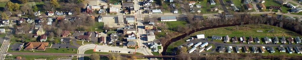
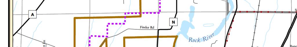
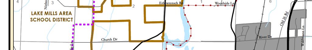
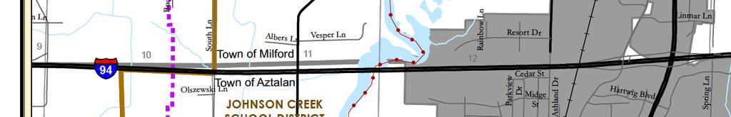
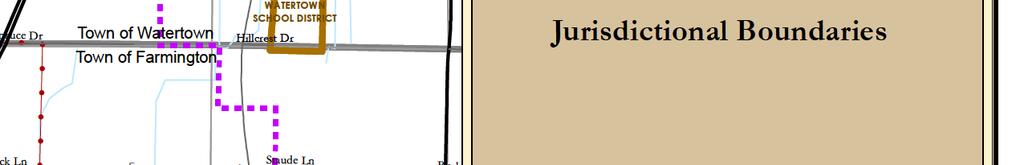
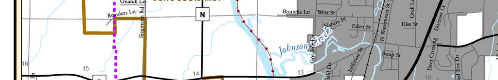
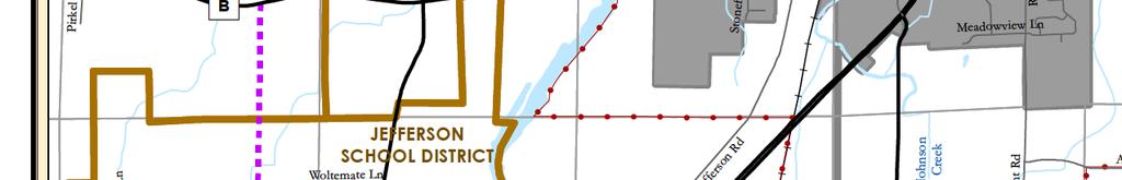
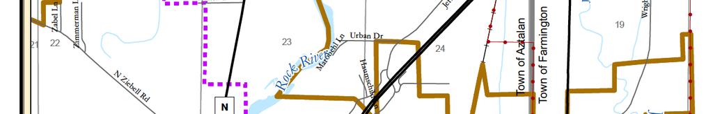
11 Introduction C. General Regional Context Map 1 shows the relationship of the Village to neighboring communities in the region. The Village is located in the north-central portion of Jefferson County, roughly 35 miles east of Madison and 45 miles west of Milwaukee. The Village is bordered on the southwest by the Town of Aztalan; on the east and southeast by the Town of Farmington; and on the north by the Towns of Farmington, Milford, and Watertown. The nearest neighboring communities are the City of Jefferson, located three miles to the south; the City of Lake Mills, located six miles west; and the City of Watertown, located five miles north. As of 2017, the Village encompassed approximately three square miles of land. The Village s extraterritorial jurisdiction abuts the extraterritorial jurisdictions of the City of Watertown to the north and the City of Jefferson to the south. D. Selection of the Planning Area The Village of Johnson Creek s planning area includes all lands currently within the Village of Johnson Creek s municipal limits, and the unincorporated areas within and just beyond the Village s 1.5-mile extraterritorial jurisdiction (ETJ). The planning area is illustrated in Map 1. Within the ETJ, state statutes enable the Village to plan for areas that bear relation to the Village s development, review subdivisions, enact extraterritorial zoning, and implement an Official Map. The ETJ expands automatically as annexations occur, hence the need for this Plan to consider and make recommendations for the area beyond the current ETJ limits. E. Key Recommendations of this Plan The graphic on the following page captures this Plan s priority recommendations. Each recommendation in the graphic includes page number(s) where additional information can be found within this document. Adopted: September 26,
12 Page intentionally left blank Introduction Adopted: September 26,


 9.")


 4.")


 11.")


13 JOHNSON CREEK COMPREHENSIVE PLAN KEY RECOMMENDATIONS Prioritize EAST-WEST ROAD CONNECTIONS ( PAGES 90-91) 8. Support Development of UPSCALE SINGLE-FAMILY HOUSING ( PAGE 112) 2. Explore a GOSDECK LANE BRIDGE (PAGE 91) 9. Support Development of HIGH-QUALITY MULTI-FAMILY HOUSING ( PAGE 113) 3. Reserve LANDS AROUND I-94/STH 26 for High-Quality Development (PAGES ) 10. Plan for the VILLAGE S PARK AND OPEN SPACES and Maintain an Up-to-Date Park and Open Space Plan (PAGE 100) 4. Continue to Address the Need for a LOCAL GROCERY STORE AND PHARMACY ( PAGE 126) 11. Conduct a LIBRARY FACILITY NEEDS STUDY ( PAGE 99) 5. Support REUSE OF THE FORMER HIGH SCHOOL and Middle School Building (PAGE 76) 12. Work with Existing Local Businesses to Promote Economic Growth and Advance Development in the MSI BUSINESS PARK (PAGE 127) 6. Establish a ROCK RIVER ENVIRONMENTAL AND RECREATION CORRIDOR and Improve Regional Bicycle Connections (PAGE 91-92) 13. Update the VILLAGE S SIGN ORDINANCE (PAGE 133) 7. Address the Growing Need for SENIOR HOUSING ( PAGE 112)
14 Page intentionally left blank Introduction Adopted: September 26,


15
16 Page intentionally left blank Introduction Adopted: September 26,
17 Chapter One: Issues and Opportunities Chapter One: Issues and Opportunities This chapter of the Plan includes an overview of demographic trends and background information for the Village. This information provides an understanding of the changes taking place in the Village of Johnson Creek. This chapter presents data on population, household and employment trends and forecasts, age distribution, educational attainment levels, and employment and income characteristics. It also includes overall goals and objectives to guide future preservation, development, and redevelopment over the 20-year planning period. A. Population Trends and Forecasts Between 2000 and 2010, the Village of Johnson Creek s population experienced an overall increase of 73.2 percent, growing from 1,581 residents to 2,738 (Figure 1.1). Over this same time period, Jefferson County s population increased by 10.5 percent, and Wisconsin s population grew by 6.0 percent. The Village s growth rate is higher than all of its neighboring communities in Jefferson County. Since 1980, the Village s rate of growth has increased, growing by roughly 26 percent between 1990 and 2000 and 73 percent between 2000 and In 2015, the U.S. Census Bureau estimated Johnson Creek s population to be 2,855. The Village s annual rate of growth has slowed in recent years. Specifically, the annual growth rate between 2010 and 2015 was approximately 0.9 percent per year, which is substantially lower than the annual growth rate between 2000 and 2015 (5.4 percent per year). Figure 1.1: Population Trends Percent Population Change Village of Johnson Creek 790 1,136 1,259 1,581 2, % Town of Jefferson 3,082 2,891 2,687 2,265 2, % Town of Aztalan 1,306 1,752 1,476 1,447 1, % Town of Milford 1,129 1,066 1,007 1,055 1, % Town of Watertown 1,671 1,921 1,840 1,876 1, % Town of Farmington 1,391 1,528 1,404 1,498 1, % City of Waterloo 2,253 2,393 2,712 3,259 3, % City of Lake Mills 3,556 3,670 4,143 4,843 5, % City of Jefferson 5,429 5,687 6,078 7,338 7, % City of Fort Atkinson 9,164 9,785 10,213 11,621 12, % City of Watertown 15,683 18,113 19,225 21,642 23, % Jefferson County 60,060 66,152 67,783 75,767 83, % State of Wisconsin 4,417,731 4,705,767 4,891,769 5,363,675 5,686, % Source: U.S. Census Bureau, Figure 1.2b shows six population projection scenarios for the Village through the year Population data for the years 1990, 2000, 2005, 2010, and 2015 that were used to develop these projections are shown in Figure 1.2a. The projections were derived using the following methodologies: Adopted: September 26,
18 Chapter One: Issues and Opportunities Wisconsin Department of Administration (WisDOA) Projection: The WisDOA provides population projections for cities and villages in Wisconsin. According to the WisDOA forecasts, the Village would see a 56 percent increase in population between 2015 and 2040, for a projected year 2040 population of 4,455. Linear Growth Rate: This scenario was calculated by determining the Village s average annual population change for the 25-year period from and projecting that forward to The Village s 25-year average was an increase of 64 people per year. Carrying this amount of annual growth forward results in a population of 4,451 by The linear growth rate and associated projection was also calculated for the 15-year period of , which yielded a higher projection of 4,978 by Annual Compounded Percentage Growth Rate: This scenario was calculated by determining the average annual rate of growth over the 25-year period from 1990 to 2015 and projecting that rate forward for the next 25 years. That growth rate averaged 5.1 percent per year would result in a population of 9,832 by Compounded growth rates and associated projections were also calculated for the last 15 years (2000 to 2015), which yielded a projection of 10,562 people by 2040 (averaging 5.4 percent per year). Compounded growth rates and associated projections for the last five years (2010 to 2015), yielded much lower growth projections of 3,532 people by 2040, which amounts to an average growth rate of less than one percent per year. For the purposes of this Plan, the Village will utilize the Linear Growth, population projection scenario as a reasonable, most likely estimate. This scenario would result in a total population of 4,978 residents by The selected population projection forecast will be used to project future housing and land demand within the Village. This is based on the increasing rate of population growth in recent years, the Village s proximity to growing metro areas, and pending expansions and improvements to STH 26. This population scenario will be used for housing and land use demand projections later in this Plan. Figure 1.2a: Village of Johnson Creek Population Trends Village of Johnson Creek 1,259 1,581 2,024 2,738 2,855 2,939 1 U.S. Census Bureau, U.S. Census Bureau, population estimates, U.S. Census Bureau, American Community Survey 5-Year Estimates 4 U.S. Census Bureau, Annual Estimates of the Resident Population: April 1, 2010 to July 1, 2016 WisDOA s previously published Population Projections (through 2025) projected that the Village would have a 2010 population of 1,828 and a 2015 population of 1,942. Actual population figures were 2,738 (2010) and 2,855 (2015). As the projections were significantly lower than the growth actually experienced in Johnson Creek, and due to the Village s strategic geographic location, the Village is comfortable using a projection that exceeds the latest WisDOA projections, by using the Linear Growth Rate from 2000 to 2015, which is shaded in Figure 1.2b below Adopted: September 26,
19 Chapter One: Issues and Opportunities Figure 1.2b: Village of Johnson Creek Population Projection Scenarios WisDOA Population Projections 3,315 3,645 3,970 4,235 4,455 Linear Growth, ,174 3,493 3,813 4,132 4,451 Linear Growth, ,280 3,704 4,129 4,554 4,978 Compounded Growth, ,656 4,682 5,996 7,678 9,832 Compounded Growth, ,709 4,818 6,259 8,131 10,562 Compounded Growth, ,979 3,109 3,244 3,385 3,532 Sources: Wisconsin Department of Administration Wisconsin Municipal Projections: ; U.S. Census Bureau; Vandewalle & Associates Demographic Trends Figure 1.3 shows the Village of Johnson Creek s age and gender distribution in 2015, compared to the surrounding communities. Although the Village s median age has increased from 31.9 in 2000 to 34.0 in 2015, Johnson Creek s median age is younger than all nearby communities. The proportion of residents over the age of 65 has decreased from 9.4 percent in 2000, to 8.5 percent in 2015 which differs from trends in most communities in Wisconsin. The current proportion of school-age children residing in the Village was comparable to surrounding communities in 2015, but is likely increasing due to the availability of housing attractive to young families. Figure 1.3: Age and Gender Distribution, 2015 Median Age Percent under 18 Percent over 65 Percent Female Village of Johnson Creek % 8.4% 49.8% Town of Jefferson % 22.7% 47.0% Town of Aztalan % 16.4% 49.5% Town of Milford % 15.0% 48.8% Town of Watertown % 17.3% 51.2% Town of Farmington % 16.8% 51.1% City of Waterloo % 14.1% 50.7% City of Lake Mills % 15.0% 52.8% City of Jefferson % 16.7% 50.3% City of Fort Atkinson % 15.3% 51.3% City of Watertown % 12.4% 50.5% Jefferson County % 14.3% 50.1% Source: U.S. Census Bureau, American Community Survey year estimates Adopted: September 26,
20 Chapter One: Issues and Opportunities Household Trends and Forecasts Figures 1.4 and 1.5 present household characteristics for the Village of Johnson Creek as compared to several surrounding communities and Jefferson County. Overall, Johnson Creek s housing characteristics are typical of a Wisconsin community of its size. However, in 2010, the Village s median rent was higher than most comparison communities, and the Village s percentage of owneroccupied housing units was comparable to the City of Lake Mills, City of Waterloo, and the average for Jefferson County. The median housing value of residential property is lower than for all nearby towns, though it is higher than that of nearby cities. Figure 1.4: Comparison of Household Characteristics, 2010 & 2015 Total Housing Units Total Households Average Household Size Median Housing Value (2015)* Median Rent* Village of Johnson Creek 1,118 1, $177,400 $891 Town of Jefferson $210,100 $639 Town of Aztalan $215,400 $883 Town of Milford $242,100 $872 Town of Watertown $220,100 $1,027 Town of Farmington $256,400 $675 City of Waterloo 1,409 1, $145,400 $805 City of Lake Mills 2,776 2, $164,600 $821 City of Jefferson 3,378 3, $144,900 $736 City of Fort Atkinson 5,429 5, $149,400 $777 City of Watertown 6,069 5, $146,700 $700 Jefferson County 35,147 32, $173,000 $775 Source: U.S. Census Bureau, 2010 and *U.S. Census Bureau, American Community Survey 5-Year Estimates Figure 1.5: Comparison of Housing Occupancy Characteristics, 2010 Percent Single Person Household Percent of Vacant Housing Percent Owner- Occupied Percent Single Family Units* Village of Johnson Creek 21.7% 6.2% 70.1% 51.1% Town of Jefferson 17.5% 6.4% 82.0% 92.2% Town of Aztalan 17.6% 3.2% 88.6% 92.5% Town of Milford 21.0% 7.0% 89.9% 94.1% Town of Watertown 18.6% 5.5% 87.8% 93.3% Town of Farmington 20.3% 6.3% 87.9% 94.8% City of Waterloo 29.2% 5.5% 70.8% 69.8% City of Lake Mills 28.2% 16.5% 66.8% 56.7% City of Jefferson 29.8% 7.3% 61.8% 55.2% City of Fort Atkinson 30.2% 5.6% 62.9% 62.3% City of Watertown 27.1% 5.6% 57.3% 62.0% Jefferson County 25.2% 8.6% 70.9% 69.9% Source: U.S. Census Bureau, 2010 and *U.S. Census Bureau, American Community Survey 5-Year Estimates Adopted: September 26,
21 Chapter One: Issues and Opportunities Figure 1.6a shows household projections for the Village through the year The Wisconsin Department of Administration provides household projections for cities and villages in Wisconsin. These figures are provided in Figure 1.6a, below. WisDOA forecasts that the Village will have 1,843 households in 2040, or an additional 794 households more than in Figure 1.6a also includes household projections that were calculated using the Linear Growth population projection from Figure 1.2b. Based upon these projections, the Village will have 2,067 households in 2040, or an additional 1,018 households as compared to For the purposes of planning, household projections are translated into an estimated demand for additional housing units. It should be noted that the demand for future housing units will be based not only on increases in population, but also on fluctuations in the Village s average household size. For example, as household sizes decreases, more housing units will be needed to meet housing demands. Both sets of projections use the WisDOA forecasts for average household size. These forecasts are shown in Figure 1.6b. Number of Households Figure 1.6a: Household Projections, Projected Number of Households # of Additional Households WisDOA Households 1,049 1,158 1,319 1,466 1,614 1,739 1, Projections Linear Growth, ,049 1,123 1,310 1,496 1,685 1,876 2,067 1,018 1 Wisconsin Department of Administration Household Projections for Wisconsin Municipalities: Extrapolated by dividing the Linear Growth, , population projections (See Figure 1.2b) by the WisDOA Persons per Households Projections (See Figure 1.6b) Figure 1.6b: WisDOA Persons per Household Forecasts, WisDOA Persons per Household Projections Source: Wisconsin Department of Administration Household Projections for Wisconsin Municipalities: Education and Employment Trends Detailed information on education and employment trends can be found in the Economic Development chapter of this Plan. B. Issues Raised Through Public Participation The Village s planning process was guided by public input that was collected through a variety of approaches, including a visioning workshop, focus groups and interviews with citizens and stakeholders, and regular meetings of the Plan Commission and Village Board. The following is a summary of those activities: Adopted: September 26,
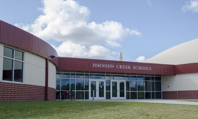
22 Chapter One: Issues and Opportunities Focus Groups and Interviews In April of 2017, the planning consultant conducted interviews with various representatives of the community. Interviewees were selected by the Village President and Village staff. The majority of interviewees fit into one of four focus groups: Village of Johnson Creek business owners, representatives of the development industry (both residential and nonresidential), community members, school district/education representatives, and park and recreation advocates. The significant outcomes of all interviews were as follows, organized by subject: General Comments: Johnson Creek is special; the comprehensive plan should be unique and different from that of other Jefferson County communities Many people live in Johnson Creek because of the location and for the small town feel Defining an identity that is unique to Johnson Creek and is beyond the STH 26 strip, the Outlet Mall, and the residential to the east and west Development: Support for new flexibility and open-mindedness about ideas for growth Promising growth in residential and commercial sectors Economic development efforts should be focused around the interchange Need more professional services, family-friendly entertainment, convenience retail (Walgreens), grocery store Strong growth pressure anticipated in the next 3 years Use of farmland for growth is inevitable given the growth trends and the fact that the Village is surrounded by farmland on all sides. Sustainable and conservation-focused development patterns are key to not losing farmland. Village should require natural features and rural attributes into new developments No senior housing options need all types (independent living and assisted living) Support from relators and builders for expanding urban service area, offering larger residential lots, growth along the Rock River (east of the river) 75% of the people building homes in Johnson Creek are from people coming from outside of Jefferson County. They are typically of working age (30s-50s) and are commuters. The County is running out of developable lots; likely to run out in 1.5 years; this will cause prices to rise if supply is low Desire to create an attractive residential home environment reasonable restrictions, affordable impact fees to keep homes affordable Village can play a role in the affordability of lots Focus residential development on connections to parks, water, trails Recommend an impact fee study in the future New development should be located near Menard s Need more homes in the $ K range Multi-family market is tight in Johnson Creek, but Village should think carefully about much multi-family and what type Adopted: September 26,
23 Business Climate: Chapter One: Issues and Opportunities Successful business owners have been successful without much help from Village Sense that new Village leadership is flexible and interested in reaching out to businesses Actual and perceived barriers/regulations to business (zoning code, sign code) Businesses would like more options/flexibility in sign code Some difficulty in finding capable employees locally Some business owners were interested in more opportunities to provide input on planning initiatives Local businesses are heavily engaged in community events and activities Opportunity for employers and Village to partner on labor force development and recruitment - recommendations for a monthly business roundtable Schools: Downtown: Improved Village and School District communication and cooperation School district image is improving; people within the community make assumptions or have outdated understanding of the district; people outside the district tend to view the district more positively School District is a leader in state on personalized learning program Negative perception of the high school has driven people away in the past The unique new school building is getting them some attention, may drive interest in moving to Johnson Creek Lack of downtown traffic makes it difficult for businesses to be successful there Downtown could use destination businesses and startup/business incubator spaces Downtown would be a good location for senior housing Transportation & Infrastructure: Bridge on Gosdeck Lane needed, but funding was diverted elsewhere Street network and connectivity to facilities is poor; need wayfinding It s hard for people to find things that aren t located on STH 26 Community s rapid growth is putting tremendous stress on the existing infrastructure and facilities Numerous specific recommendations for improvements and maintenance at existing parks Need to update Park and Open Space Plan Community pool or splash pad recommended Village should plan to increase park staffing to care for facilities as the system expands Future natural area park on the Creek Would like to see a bike path along STH 26 Close regional trail gaps, improve connections to Glacial River Trail Adopted: September 26,
24 Chapter One: Issues and Opportunities Vision Workshop In April of 2017, the Village held a Vision Workshop to provide an opportunity for residents to identify a shared vision for the Village, express concerns for the future of the Village, and to develop priority actions for the Village to address over the next 10 years. During the workshop, participants were asked to identify and prioritize key values and opportunities, as well as significant threats and challenges. They were also asked to map opportunities and help the Village identify priorities for taking action in the next ten years. A compilation of all workshop results is available at Village Hall. A summary of workshop results follows below. Workshop participants were asked to share what they valued most about Johnson Creek, what threats or challenges the Village faces, and what trends/opportunities/assets they see in the Village. Top Values included: People, location, business The small-town feel / It is a community / country atmosphere Convenient geographic location, access to Madison, Milwaukee, Janesville Green space Opportunities for leadership Fire/EMS Top Threats included: Infrastructure upgrades needed well #4, 2 nd water tower, sewer plant Not prepared for growth. Water quality State aid competition Landfill River flooding Diversity I-94 & STH 26 Great place to raise children / family friendly Strong village leadership Jobs in major employment markets Safe Good schools Growth (both positive and negative) Keeping commercial in check That we don t continue to grow State and federal government Municipal competition Lack of diversity elected officials Economic downtown could reverse growth or stagnate it. Top Challenges included: How do we pay for growth without increasing taxes? Access to the west side of Village / East-west street connectors / Lack of through streets Only community without Main Street no true downtown. Sustaining right the right pace of growth / Keeping up with growth do it right. Keep growing with income. Keeping up with other towns what they have to give away Expansion direction E, W, N, S Bring business, people to our community. Program lack of activities for families to stay in Creek. Lack of supermarket and pharmacy Sustained economic growth and income, failing downtown Lack of citizen engagement With growth comes extra infrastructure, and you have to keep up with the needs. Adopted: September 26,
25 Top Trends included: New school Growing at a smooth, continuous pace Top Opportunities included: Room for growth both residential and business. More targeted stores Tourism potential Corporate headquarters Use growth to help tax base STH 26 & I-94 corridor Continue to grow and make it a place everyone wants to live in Chapter One: Issues and Opportunities Upper-income apartments Fast-growing community in Jefferson County (2) Geographic location Library Appeal to younger family/commuters/those with high incomes Great access to major economic markets Attractive community. Top Assets included: Transportation resources (Hwy 26 & Hwy I-94) access and traffic counts New school that is developing a good reputation Educated population Able to grow in all four directions. Hwy 26 & 94 Growth could lead to lower property taxes Fire/EMS, police Our residents, our post office, bank, mall, parks, community center Centrally located between major cities Passionate people Green space Following discussion and consensus on the issues summarized above, small groups were asked to identify areas in and around the Village that they thought should be emphasized in the Comprehensive Plan. Each small group marked up a map of the Village to indicate areas of concern or areas where opportunities exist. They were asked to identify new road connections, new bicycle/pedestrian facilities, infill and redevelopment sites, preservation areas, gathering places, and transportation issues. A summary of this input is as follows: Key infill and redevelopment sites included the undeveloped land south of Deer Crossing. Areas to be preserved included environmental corridors and floodplain along the Rock River Key gathering places included Village Hall, the natural areas alongside the Creek, Centennial Park, the open space west of Centennial Park (future boat ramp suggested), recommended parks and natural areas along the Rock River Transportation issues were identified at Aztalan Street at Stonefield Drive, Hartwig Boulevard near Watertown Street, South Street just north of STH 26. There were also numerous comments about the lack of east-west connections in the Village. New or improved road connections included a bridge over the Creek connecting Gosdeck Lane to Aztalan Street, extending Midget Street over the railroad tracks to Watertown Street, extending Hartwig Boulevard west to CTH Y, and several other east-west connections. There were also several suggested to link westside neighborhoods west to the Rock River and south to STH 26. Adopted: September 26,
26 Chapter One: Issues and Opportunities Multi-use trails were recommended along the west bank of the Rock River, connecting westside neighborhoods to the Creek, and connecting natural areas and parks within the southeast neighborhoods to one another. A north-south trail was also recommended, starting at CTH Y north of the Village, heading west on Resort Drive, roughly following the current western municipal limits south to Stonefield Drive, and continuing south to STH 26 south of the Village. This trail could potentially be a preferred route for the regional Glacial River Trail, as opposed to the current route which is primarily on-street. Participants were also asked to identify locations that would be appropriate for new residential, commercial, or industrial development. A summary of this input is as follows. New residential development was recommended in all directions, particularly to the southeast of the Village, south of Menard s Lane, east of Hunters Glen Lane, south and southeast of the new school, along the Rock River, east of Centennial Park, in the Resort Drive area, and north of River Drive west of CTH Y. New commercial development was recommended north of Resort Drive, at the I-94/STH 26 interchange, along both sides of STH 26 (north and south of I-94), at Milwaukee Street near STH 26m and along Hartwig Boulevard. New industrial development was recommended along Rainbow Lane, north of Resort Drive, and west of Spring Lane. Finally, participants were asked to share their top priorities for the Village to address over the next decade. The group developed a list of priorities, and then each person was provided five sticky dots to place next to their preferred priorities. Participants could place as many dots as they would like next to any given priority. Top priorities included (in order of the most highly-rated): 1. East-West connecting roads 2. Family-oriented community 3. Senior Housing 4. Paths and trails 5. Public facilities and utilities 6. Commercial and industrial 7. Redevelopment 8. Community identity signage 9. Green space Draft Plan Review Open House On August 10, 2017, the Village conducted a public open house on a public review version of the draft Plan. Over 15 individuals attended. Written comments were mostly supportive of draft Plan. A few individuals shared concerns about potential safety issues that could be associated with a Gosdeck Lane bridge. Others drew attention to the lack of transportation options available to seniors in the Village. One individual suggested planning for more land for Single Family Residential Large Lot uses and moving the Village s urban service area south to Urban Drive. Another individual suggested that the Village develop a master plan for Conservancy Park in order to create an attractive public space and further support the residential development in that area. Public Hearing On September 26, 2017, the Village Plan Commission and the Village Board held a public hearing on the Plan, in accordance with state statutes. Following the public hearing, the Plan Commission recommended the Plan to the Village Board by resolution. Immediately following, the Village Board adopted the Plan by ordinance. Adopted: September 26,
27 Chapter One: Issues and Opportunities C. Regional Influences In order to more accurately guide Johnson Creek s future growth and development, it was important to begin the comprehensive planning process by analyzing the numerous factors in and around Jefferson County that will impact Village growth (See Map 2). Some of most significant influences include the following: Proximity to Major Employment, Shopping, and Entertainment Centers The Village of Johnson Creek is located within driving distance of several major regional employment centers, shopping destinations, and entertainment venues. Located roughly 45 minutes west of the Village, the City of Madison in Dane County hosts a number of employment options, including the state capital, the University of Wisconsin, several regional medical centers, and a regional bioagriculture research center. In addition, State Street, the Farmer s Market, the Overture Center, Union Terrace, and numerous restaurants and bars are just several of the entertainment and shopping options available in Madison. In 2016, the private sector job growth rate for Dane County (2.0%) was four times higher than the growth rate for the State of Wisconsin (0.5%). Dane County has consistently experienced lower unemployment rates than the State average as well. Downtown Milwaukee and the surrounding suburbs are also well within an hour s drive of Johnson Creek. The Milwaukee Metro region offers significant employment options, including the Milwaukee County Research Center, the County Regional Medical Center, and St. Luke s Medical Center. Numerous entertainment venues and shopping destinations are also available in the area, such as Miller Park, the Milwaukee County Zoo, Pier Wisconsin, the Milwaukee Public Museum, Mayfair Mall, and the Mayfair Collection. To the southwest, the cities of Janesville and Beloit are located within an hour of Johnson Creek, as is the Fox Valley to the northeast. For weekend excursions, downtown Chicago is less than two and a half hours from the Village. Access to Transportation Networks As energy costs rise, efficiency in travel is becoming an increasingly important issue around the nation. An analysis of commuting patterns indicates that every day over 17,000 people commute from Jefferson County to the immediately adjacent counties of Waukesha, Dodge, Dane, Rock, and Walworth. Centered on the junction of I-94 and STH 26, the Village of Johnson Creek is on a direct route to Madison, Milwaukee, Janesville, Beloit, the Fox Valley, and Green Bay, as well as many of the Midwest s other major economic centers, including Chicago, Minneapolis, and Detroit. Jefferson County is also traversed by US Highways 12 and 18 and State Highways 19 and 89, and has a direct connection with I-39/90, located west of Jefferson County. For more distant travel, Johnson Creek is also within an hour s drive from both the Dane County Regional Airport in Madison and General Mitchell International Airport in Milwaukee. As a benefit to local businesses, the County is served by three major railroads: the Wisconsin & Southern Railroad Co., Canadian Pacific Railway, and the Union Pacific Railroad, which travels directly through Johnson Creek. Adopted: September 26,

28 Chapter One: Issues and Opportunities Abundance of Recreational Resources and Open Space Nestled between five growing metro areas, Jefferson County s natural landscape has remained relatively undisrupted by development. The County s roadways offer views of glacial drumlins more pronounced than almost anywhere else in the world. Moreover, with nine State Natural Areas and parks, six Land Legacy Places, access to two state trails, and an abundance of water resources, including wetlands, lakes, and rivers, Jefferson County serves as a vast playground for people who thrive on being outdoors. Although Jefferson County communities are facing increasing growth pressures, residents and property owners are taking measures to preserve rural character and the expanses of farmland that still blanket the towns and surround the villages and cities. These communities recognize that it is in large part the County s natural beauty and wide open spaces that will continue to make this area of Wisconsin such a desirable place to live and visit. D. Johnson Creek Opportunities Map 3 illustrates the most significant opportunities identified for Johnson Creek s planning area. These opportunities were identified early in the planning process to help guide Plan direction. The ideas presented on Map 3 have been expanded on in other chapters of this Plan. E. Johnson Creek Vision Statement The following two paragraphs capture Johnson Creek s vision for the future. A Vision Statement is intended to broadly describe how a community would like to look, feel, and function in the future. All of the goals, objectives, policies, programs, and actions outlined in this Plan are intended to move the Village towards achieving this vision. In the year 2045, the Village of Johnson Creek will be the picture of small-town charm, and a peaceful and safe place to live and raise a family. Over the years, Johnson Creek will have effectively balanced economic growth with the preservation of village character by calling upon the knowledge, creativity, and expertise of the people who make up the community; by reserving key sites around the I-94 and STH 26 corridors for tax base development and employment land uses; and by embracing new opportunities and progressive ideas for sustaining quality of life. In 2045, the streets of the downtown will be alive with family and friends gathering in the local shops and cafes. Children and adults will enjoy walking and biking safely and conveniently to the Village s parks, schools, and businesses. New neighborhoods will be well-designed to minimize impacts on the County s irreplaceable farmland and natural resources, and the Village will be a model for sustainable development practices. A variety of housing options will provide opportunities for a diversifying population, while local festivals, markets, and civic events continue to symbolize Johnson Creek s traditions, culture, values, and community pride. Adopted: September 26,
29
30 Chapter One: Issues and Opportunities Page intentionally left blank Adopted: September 26,
31
32 Chapter One: Issues and Opportunities Page intentionally left blank Adopted: September 26,

33 Chapter One: Issues and Opportunities F. Goals, Objectives, Policies, Programs, and Recommendations Each subsequent chapter of this Comprehensive Plan includes goals, objectives, policies, programs, and recommendations that will provide direction and policy guidance to Plan Commission members, Village Board members, residents, and other interested groups and individuals for the next 20+ years. Goals, objectives, policies, programs, and recommendations are defined below: Goals are broad, advisory statements that express general public priorities about how the Village should approach development issues. Goals are based on key issues and opportunities that are affecting the Village. Objectives more specifically identify future direction. By accomplishing an objective, the Village moves closer to achieving its goals. Policies are rules or courses of action implemented to achieve specific objectives. Village staff and officials should use policies on a day-to-day basis when making decisions. Programs are specific projects or services that are intended to move the Village toward achieving its goals, objectives, and policies. Recommendations provide detailed information regarding how to implement objectives, policies, and programs. VILLAGE OF JOHNSON CREEK OVERALL PLANNING GOALS Protect and enhance natural features and ecological systems in the Village s planning area. Preserve, enhance, and promote the Village s small-town, historic character and charm. Promote a future land use pattern in and around the Village that is economically efficient and environmentally sustainable, helps maintain property values, preserves the community s predominately residential character, encourages well-planned and attractive development, and minimizes land use conflicts. Preserve the agricultural character of the surrounding Towns by directing nonagricultural uses into the Village and by supporting an orderly, efficient development pattern. Provide a safe and efficient transportation system that meets the needs of multiple users in and around the Village, including pedestrians, motorists, and bicyclists. Develop and maintain a comprehensive system of bicycle and pedestrian facilities in and around the Village to encourage alternative transportation and a healthy, active lifestyle. Promote an effective and efficient supply of utilities, community facilities, and public services that meet the expectations of Village residents and business owners. Ensure the provision of a sufficient number of parks, recreational facilities, and open space areas to enhance the health and welfare of Village residents and visitors. Provide a variety of housing types at a range of densities, arrangements, and costs to accommodate the needs and desires of existing and future residents. Attract and retain businesses that capitalize on Johnson Creek s regional position, enhance the Village s character and appearance, strengthen and diversify the non-residential tax base and employment opportunities, serve the day-to-day needs of residents, and help create a desirable place to live, work, and visit. Develop and maintain mutually beneficial relationships with adjacent and overlapping governments. Adopted: September 26,
34 Chapter One: Issues and Opportunities Page intentionally left blank Adopted: September 26,

35 Chapter Two: Agricultural, Natural, and Cultural Resources Chapter Two: Agricultural, Natural, and Cultural Resources This chapter of the Comprehensive Plan contains background data, goals, objectives, policies, and recommended programs for agricultural preservation, natural resource conservation, and cultural resource protection. Agricultural Resources A. Character of Farming Agriculture is one component of Johnson Creek s economy and way of life. According to the 2006 land use inventory, agricultural land accounts for approximately 30 percent of the Village s total land area, and a much greater percentage of the surrounding towns is in agriculture. Crop farms, primarily corn and soybeans, are generally located around the periphery of the Village. B. Assessment of Farmland Viability AGRICULTURAL RESOURCE RECOMMENDATIONS SUMMARY Utilize extraterritorial land division review to limit rural housing development in the Village s extraterritorial jurisdiction. Encourage the future siting and development of bio-based business center in the northwestern portion of the community, north of the Interstate in the industrial park. The Natural Resources Conservation Service groups soils based on their capability to produce common cultivated crops and pasture plants without deteriorating over a long period of time. These capability classifications are based on numerous criteria that include, but are not limited to, the soil s salinity, capacity to hold moisture, potential for erosion, depth, and texture and structure, as well as local climatic limitations (e.g. temperature and rainfall). Under this system of classification, soils are separated into eight classes. Generally, Class I and Class II soils are the best suited for the cultivation of crops. Class I soils have few limitations that restrict their use. These soils can sustain a wide variety of plants and are well suited for cultivated crops, pasture plants, range lands, and woodlands. Class II soils have moderate limitations that restrict the types of plants that can be grown or that require simple conservation practices or soil management techniques to prevent deterioration over time. However, these practices are generally easy to apply, and, therefore, these soils are still able to sustain cultivated crops, pasture plants, range lands, and woodlands. Soils in Class III have severe limitations that, under natural circumstances, restrict the types of plants that can be grown, and/or that alter the timing of planting, tillage, and harvesting. However, with the application and careful management of special conservation practices, these soils may still be used for cultivated crops, pasture plants, woodlands, and range lands. Soils in capability Classes IV through VIII present increasingly severe limitations to the cultivation of crops. Soils in Class VIII have limitations that entirely preclude their use for commercial plant production. Map 4 depicts the locations of Class I, II, and III soils in and near the Village of Johnson Creek. There are not any Class I soils within the Village. Class II and III soils are well distributed throughout the Adopted: September 26,

36 Chapter Two: Agricultural, Natural, and Cultural Resources Village, with Class II soils accounting for approximately 58 percent of the Village s total land area and Class III soils accounting for approximately 26 percent of the total land area. C. Farmland Preservation Efforts Local farmers can participate in several federal and State programs and initiatives that are intended to preserve long-term farming activities. The 2014 Farm Bill reauthorized several federal programs, including: The Conservation Reserve Program (CRP), which provides technical and financial assistance to eligible farmers and ranchers to address soil, water, and related natural resource concerns on their lands in an environmentally beneficial and cost-effective manner. The Agricultural Conservation Easement Program (ACEP) provides financial and technical assistance to help conserve agricultural lands and wetlands and their related benefits. Under the Agricultural Land Easements component, NRCS helps American Indian tribes, state and local governments and non-governmental organizations protect working agricultural lands and limit non-agricultural uses of the land. Under the Wetlands Reserve Easements component, NRCS helps to restore, protect and enhance enrolled wetlands. The Grazing Lands Conservation Initiative, which focuses on providing technical assistance to help new grazers begin using rotational grazing methods. Trained grazing specialists work one-on-one with farmers, developing grazing plans, including seeding recommendations, fencing and watering plans. The Environmental Quality Incentives Program (EQIP), which provides a voluntary conservation program for farmers and ranchers who promote agricultural production and environmental quality as compatible national goals. EQIP offers financial and technical help to assist eligible participants install or implement structural and management practices on eligible agricultural land. Portions of the repealed Wildlife Habitat Incentive Program (WHIP) Statute were rolled into the EQIP. In addition, the Wisconsin Department of Revenue offers two important farmland preservation programs, the Farmland Preservation Credit Program and the Farmland Tax Relief Credit Program. The Farmland Preservation Credit Program strives to preserve Wisconsin farmland by means of local land use planning and soil conservation practices and provides property tax relief to farmland owners. To qualify for the credit, farmland must be 35 acres or more and zoned for exclusive agricultural use or be subject to a preservation agreement between the farmland owner and the State. In addition, in order to be eligible for Adopted: September 26,
37 Chapter Two: Agricultural, Natural, and Cultural Resources this credit, all program participants must comply with soil and water conservation standards set by the State Land Conservation Board. The Village of Johnson Creek does not have exclusive agriculture zoning. The Farmland Tax Relief Credit Program provides direct benefits to all farmland owners with 35 or more acres. The credit is computed as a percentage of up to $10,000 of property taxes, with the maximum credit of $1,500. D. Agricultural Resource Goals, Objectives, and Policies Goals Preserve the agricultural character of the Village s planning area by supporting an orderly, efficient development pattern that directs nonagricultural uses into the Village. Objectives 1. Promote compact development patterns and maintain a hard-edge between Village development and the countryside. 2. Direct new homes to smaller lots in locations where housing and other development is already located. 3. Discourage land uses, land divisions, and activities that may conflict with agricultural uses or adversely affect farm investments in long-term farming areas around the Village. 4. Work with the surrounding towns and Jefferson County to help preserve farming as a viable occupation and way of life. Policies 1. Work with surrounding towns and Jefferson County to encourage an orderly, efficient development pattern that minimizes conflicts between urban and rural uses and that preserves agricultural character. 2. Work with surrounding towns and Jefferson County to encourage a land use pattern that directs more intensive development into the Village or into other urban communities and preserves natural resources and productive agricultural lands in rural areas. 3. Work cooperatively with Jefferson County and the surrounding towns to explore innovative techniques for preserving agricultural lands in the towns, including a purchase of development rights program. 4. Support the continuation and expansion of agricultural support businesses and industries in appropriate areas designated in this Plan. 5. Where appropriate, encourage compact development as well as infill and redevelopment within the Village to preserve lands outside the Village for agriculture. 6. Support business development and direct marketing opportunities (e.g. farmers market) that enhance local markets for farm products. Adopted: September 26,

38 Chapter Two: Agricultural, Natural, and Cultural Resources E. Agricultural Resource Programs and Recommendations 1. Limit Residential Development within the Village s Extraterritorial Jurisdiction Keeping non-farm development out of farming areas is a key component of an overall program of farmland preservation. With the exception of some limited areas of existing exurban residential development in the Town of Aztalan southwest of the Village and in the Town of Watertown northeast of the Village, the majority of the lands outside the Village s limits that are not in environmental corridor have been indicated on the Village s Future Land Use map (see Map 7) as appropriate for continuation in agricultural use. The Village intends to exercise its subdivision review authority within its 1.5-mile extraterritorial jurisdiction to limit housing development in these areas, instead directing intensive development (e.g. subdivisions, multi-family residential, commercial, industrial) to the Village or other incorporated communities. This recommendation is discussed further in the Land Use chapter and in the Intergovernmental Cooperation chapter. 2. Develop New Uses for Agricultural Products Advances in technology are opening up new markets for traditional agricultural products. The new bio-economy is focused on finding new ways to use and process corn, soybeans and other organic matter into new marketable plastics, fuels such as bio-diesel and ethanol, and even pharmaceuticals. At the same time that production costs are declining to process these materials, environmental regulations are becoming more stringent, green economic incentives are becoming more widespread, and costs associated with petroleum are rising. Wisconsin is in a favorable position to be able to supply raw materials for the rising bio-economy. To compete with the efforts of other states and regions, Wisconsin has launched a state-wide initiative to position itself to take advantage of this emerging economy. The Village of Johnson Creek is ideally located near a major research and development center at the University of Wisconsin-Madison, agricultural producers, and the manufacturing centers of eastern Wisconsin, north central Illinois, and Chicago. This location places the Village in an excellent position to be a source of raw materials for bio-based products. In addition, the Village s immediate access to I-94 and STH 26, make the Village a prime location for future bio-business operations in Jefferson County and the State as a whole. There is a potential opportunity for the Village to encourage the future siting and development of biobased business center in the northwestern portion of the community, north of the Interstate in the industrial park (also see the Economic Development chapter). THE WISCONSIN CONSORTIUM ON BIO-BASED INDUSTRY The term bio-economy is used to refer to the production of products, chemicals, and energy from renewable bio-mass (crops, crop waste, wood) that are currently produced primarily from non-renewable fossil fuels, such as petroleum. Ethanol from corn and bio-diesel from crop waste are well known examples of fuels created from biomass. Research is underway to unlock the potentially much higher energy yields from other organic sources such as grasses, legumes and timber, all of which are readily grown in Wisconsin. However, the potential for bio-mass is not limited to fuels. Many products that can be made from petroleum, such as plastics and lubricants, can also be made from bio-mass. Growing concerns over rising energy costs, dependency on foreign sources of petroleum, global climate change, and environmental degradation, have been matched by growing interest in the emerging bioeconomy. By virtue of its natural resources, strong agricultural and forestry economies, and research facilities, the State of Wisconsin is in a strong position to develop and expand its bio-economy and biobased industries. Adopted: September 26,
39
40 Chapter Two: Agricultural, Natural, and Cultural Resources Page intentionally left blank Adopted: September 26,

41 Chapter Two: Agricultural, Natural, and Cultural Resources Natural Resources A survey of Johnson Creek s natural resources provides a framework for guiding NATURAL RESOURCE RECOMMENDATIONS several elements of the Comprehensive Plan. As SUMMARY a growing community, such information can help identify the appropriate locations for Take a leadership role in promoting certain types of development, and can environmental health, and encourage the pinpoint areas that should be preserved and construction of energy-efficient buildings. managed for recreational purposes, Protect environmental corridors, stormwater management, and ground water groundwater, and surface water by protection. Maintenance of these natural maintaining a compact development pattern features is also important for community and promoting stormwater best management appearance and for the functions they practices. perform for natural communities. Map 5 in this Plan depicts the Village s key environmentally sensitive areas, some of which are described in more detail below. A. Ecological Landscapes An ecological landscape is defined as a region of Wisconsin characterized by a unique combination of physical and biological attributes, such as climate, geology, soils, water, or vegetation. Different ecological landscapes offer distinct management opportunities based upon their levels of biological productivity, habitat suitability for wildlife, and presence of rare species and natural communities. The Village of Johnson Creek falls entirely within the Southeast Glacial Plains Landscape. Understanding the distinct attributes of this landscape will be important when identifying future land management and land use goals. Many of these attributes are identified in the following sections. B. Topography The topography in the Village of Johnson Creek was shaped over 10,000 years ago by Wisconsin s most recent period of glacial activity. The landscape is characterized by gently rolling drumlins that were formed by material deposited along the edges of the ice sheet during the glacier s retreat. Elevations in the Village range from approximately 785 feet above sea level to roughly 900 feet above sea level. C. Metallic and Non-Metallic Resources There are no active mineral extraction sites located in Johnson Creek or immediately surrounding Johnson Creek. However, under State Statutes (295.20), landowners who want to register their property as a nonmetallic mining deposit are required to notify each county, city, village and/or town that has zoning authority over their property. D. Groundwater Groundwater is comprised of the portion of rainfall that does not run off to streams or rivers and that does not evaporate or transpire from plants. This water percolates down through the soil until it reaches the saturated zone of an aquifer. Groundwater supplies all of the water for domestic, commercial and industrial uses in the Village of Johnson Creek. Adopted: September 26,
42 Chapter Two: Agricultural, Natural, and Cultural Resources The quality of groundwater in the Village is generally good. However, groundwater availability and quality will continue to be an important issue for Jefferson County. In the last few decades, the number of high-capacity wells in the region has increased to accommodate growth. Such deep wells not only threaten to deplete the aquifer, but also disturb areas of the aquifer in which natural contaminants are found in higher concentrations, such as radium, arsenic, lead, fluoride, and iron. In the rural areas located immediately around the Village, a potential groundwater contaminant is nitrate-nitrogen, which can come from improperly functioning on-site wastewater systems, animal feedlots, livestock waste facilities, sludge and septage application, lawn and agricultural fertilizers, and decaying plant debris. Well draw-down is a significant issue on the eastern and western margins of Jefferson County, primarily associated with rapid growth in Waukesha County and Dane County. E. Watersheds and Surface Waters The Village is located within the Johnson Creek and Middle Rock River watersheds in the Upper Rock River Basin. The Rock River Basin covers approximately 3,777 square miles and incorporates 10 counties in southern Wisconsin. Water from the Rock River Basin enters the Mississippi River via the Rock River and eventually ends up in the Gulf of Mexico. The main trunk of the Rock River flows south through the Cities of Watertown, Jefferson, and Fort Atkinson in Jefferson County. Two surface water features are located within the Village: Johnson Creek and Spring Creek. Johnson Creek traverses the southern portion of the Village, and Spring Creek is a small drainageway that runs through the center of the Village, parallel to the railroad tracks. The Rock River is located just west of the Village s current boundaries. Rock River F. Floodplains The Federal Emergency Management Agency (FEMA) designates floodplains. These are areas predicted to be inundated with flood waters in the 100-year storm event (e.g., a storm that has a 1 percent chance of happening in any given year). Development within floodplains is strongly discouraged so as to limit property damage. The Village of Johnson Creek Floodplain Ordinance regulates development within floodplain areas. Map 5 shows the 147 acres of land in the Village classified as 100-year floodplain, comprising approximately eight percent of the Village s total land area. Floodplain areas in the Village are located primarily along Johnson Creek and Spring Creek. Significant floodplain areas are also Adopted: September 26,
43 Chapter Two: Agricultural, Natural, and Cultural Resources located along the Rock River, just west of the Village, presenting significant limitations to development. The National Flood Insurance Program maps produced by the FEMA should be referenced for official delineation and elevations of floodplain boundaries. G. Wetlands According the Wisconsin DNR s Wetland Inventory Maps, wetland habitats comprise approximately 11 percent (215 acres) of the Village s total land area, not including small tracts of wetland that are less than five acres in size. These ecosystems play significant roles in maintaining the quality of groundwater and surface water and provide valuable habitats for fish, birds, and other wildlife. Wetland areas are scattered throughout the Village, but are most concentrated in the areas surrounding Johnson Creek and Spring Creek. The Village of Johnson Creek Shoreland/Wetland Ordinance regulates the use and development of wetlands within 300 feet of navigable streams and 1,000 feet of lake and ponds and controls for lands annexed into the Village. H. Woodlands and Natural Vegetation The Village of Johnson Creek s native vegetation consists of a mix of prairie lands, oak forests, maplebasswood forests, savannas, wet-mesic prairies, southern sedge meadows, emergent marshes, and calcareous fens. Agriculture and development have significantly changed vegetative cover in this part of the state. Much of the natural vegetation has been removed and undeveloped areas are dominated by croplands. I. Steep Slopes As shown on Map 5, slopes exceeding a 12 percent grade are scattered throughout the northeastern and southwestern portions of the Village. Generally, slopes that have between a 12 and 20 percent grade present challenges for building site development, and slopes that exceed a 20 percent grade are not recommended for any disturbance or development. J. Rare Species Occurrences/Natural Areas WisDNR s Natural Heritage Inventory program maintains data on the general location and status of threatened or endangered plant and animal species and natural communities and species and communities of special concern. While information is not available at the Village level, according to this inventory, the towns of Aztalan, Farmington, and Milford (within which the Village is located) collectively have two animal species, two plant species, and one natural community that fall into one of these categories. Animal species include the Redfin Shiner and the Blanchard s Cricket Frog. More specific information on location and type of species is available from the State s Bureau of Endangered Resources. K. Environmental Corridors Environmental Corridors are continuous systems of open space that include 100-year floodplains, wetlands, steep slopes above 20 percent, and contiguous woodlands. Environmental corridors are located throughout the Village and generally correspond with other natural features as seen on Maps 5 through 7. It is Jefferson County s policy to discourage development within areas that have been identified as environmental corridor. However, as documented in the County s Agricultural Preservation and Land Use Plan, if and when development is permitted within an environmental corridor, it is recommended that it not exceed one dwelling unit per ten acres. The Village of Johnson Adopted: September 26,
44 Chapter Two: Agricultural, Natural, and Cultural Resources Creek Zoning Ordinance protects the various components of environmental corridors, including floodplains, wetlands, drainageways, steep slopes, and woodlands. L. State Natural Areas/Wildlife Areas The Village does not have any state natural areas or wildlife areas within its boundaries. The two closest Wildlife Areas are the Waterloo Wildlife Area, located northwest of the Village in the Town of Waterloo, and the Lake Mills Wildlife Area, located in the Town of Lake Mills, just to the southwest of the City of Lake Mills. State wildlife areas are intended to preserve wild lands for hunters, trappers, hikers, wildlife watchers, and all people interested in the out-of-doors. Furthermore, these areas help protect and manage important habitat for wildlife and help prevent draining, filling, and destruction of wetlands and the private blocking of important waterways, game lands, and lakes. State natural areas are intended to protect the state's natural diversity, provide sites for research and environmental education, and serve as benchmarks for assessing and guiding use of other lands in the state. Natural areas consist of tracts of land or water that have native biotic communities, unique natural features, or significant geological or archeological sites. M. Glacial Heritage Area Project The Glacial Heritage Area Project is an effort led by the WisDNR to establish a network of conservation areas, recreational facilities, and recreation trails in the Glacial Heritage Area in Southeastern Wisconsin. This area is centered on western Jefferson County, but includes portions of Dane County, Dodge County, Rock County, and Walworth County. The primary goal of the project is to help meet the demand for outdoor, nature-based, land and water recreational activities in the state by setting aside lands for hiking, biking, wildlife watching, camping, horseback riding, hunting, fishing, boating, and other activities. The portion of Southeastern Wisconsin that is known as the Glacial Heritage Area already boasts one state park, eleven large State Wildlife Areas, twelve State Natural Areas, the Glacial Drumlin and Glacial River trails, numerous county parks, and lands owned by private conservation groups. These resources provide the foundation for establishing an intricate network of strings and pearls, in which conservation areas and parks represent the pearls, and trails represent the strings. Another goal of this project is to directly connect these outdoor recreational resources with the numerous communities located within the Glacial Heritage Area. The Village of Johnson Creek is located within the project s primary study area, within which WisDNR is hoping to identify the majority of its new strings and pearls. Therefore, the future growth plans of the Village will be important in helping WisDNR identify future lands for acquisition and future opportunities for connecting these lands to people. N. Natural Resource Goals, Objectives, and Policies Goals Protect and enhance natural features and ecological systems in the Village s planning area. Objectives 1. Continue to recognize that the Johnson Creek s character is in large part defined by the abundance of natural resources and open spaces located in and around the Village. Adopted: September 26,

45 Chapter Two: Agricultural, Natural, and Cultural Resources 2. Protect natural features, including wetlands, lakes, woodlands, wildlife habitats, open spaces and groundwater resources, and other environmentally sensitive features. 3. Protect surface water and groundwater quality, specifically associated with the Rock River and Johnson Creek. 4. Link the preservation of natural resources with recreational and economic opportunities for residents and visitors. Policies 1. Continue to utilize overlay zoning, subdivision review authority, and official mapping authority to protect environmental corridors and significant environmental features within Village limits and extraterritorial jurisdiction. 2. Preserve significant natural features by prohibiting new construction in mapped environmental corridors. Require all site plans, preliminary plats, and certified survey maps to accurately depict all environmental corridor natural resource elements (e.g. wetlands, floodplains, steep slopes, drainageways, etc.) that are found on the site. 3. Require natural resource features to be depicted on all site plans, preliminary plats, and certified survey maps in order to facilitate preservation of such features. 4. Protect groundwater quality by encouraging the clean-up of environmentally contaminated sites, monitoring uses that may cause contamination in the future, identifying and protecting wellhead protection areas for municipal wells, and maximizing infiltration in groundwater recharge areas. WHAT IS SUSTAINABILITY? The term sustainability refers to a community s capacity to support the long-term health and welfare of its natural and man-made environment, as well as all forms of life that depend on that environment. A sustainable community is focused not only on protecting natural resources, but also on ensuring a high quality of life for all residents. To achieve an increased level of sustainability, a community must recognize the interconnectedness of all things, as well as the impact their actions have on the greater region and the world. A community can advance sustainability through a variety of strategies such as promoting comprehensive transportation networks and services; ensuring a variety of housing options throughout the community; investing in a strong economy that provides a diversity of local jobs, goods, and services; supporting well designed development that preserves high-quality farmland and complements the natural environment; seeking out opportunities to reduce non-renewable energy consumption and waste; and generally by developing comprehensive solutions to resolving complex issues. 5. Protect the area s natural resources, particularly the Rock River and Johnson Creek, to protect threatened or endangered species and other wildlife, and to promote local economic development. 6. Cooperate with other units of government and non-profit land conservation agencies on the preservation of natural resources that are under shared ownership or that cross jurisdictional boundaries. 7. Where appropriate, encourage a compact development pattern, mixed use development, infill, and redevelopment in the Village to preserve open spaces and natural resources. 8. Support responsible, low-impact development practices that promote the preservation of natural resources. Adopted: September 26,
46 Chapter Two: Agricultural, Natural, and Cultural Resources 9. Enhance and enforce erosion control and stormwater management standards. Emphasize the use of natural drainage systems, construction site erosion control and permanent, ongoing stormwater management and erosion control measures that control the quality, quantity, and temperature of water leaving any site. 10. Review and revise Village ordinances as needed to ensure that they encourage or at least do not prevent property owners or developers from engaging in environmentally-friendly practices. 11. Support and participate in the Glacial Heritage Project and other initiatives that are focused on preservation and enhancement of natural resources. 12. Discourage the establishment of new mineral extraction operations within the Village limits, except where they are associated with a development project on the same site and are operated according to safe and clean standards. O. Natural Resource Programs and Recommendations 1. Help Identify and Preserve New Lands within the Glacial Heritage Area Because the Village of Johnson Creek is located within the Glacial Heritage Area Project s primary study area, it will be important for the Village to remain involved in the project s ongoing feasibility study process, which is intended to identify lands appropriate for future acquisition and preservation. Johnson Creek also intends to continue to work with WisDNR to coordinate possible connections between public recreation areas and Village neighborhoods. The Village s Future Land Use map (Map 7) will also be an important tool in helping the WisDNR to identify which areas are most appropriate for further study and analysis. 2. Take a Leadership Role in Promoting Environmental Health The Village can involve its residents and business owners in promoting a healthier natural environment. More specifically, the following strategies may be implemented: With UW-Extension and Jefferson County, organize opportunities to educate the public on the Village s eco-municipality initiative. It will be important for the Village to communicate the definition of an eco-municipality, what this means for residents and business owners, and how promoting a sustainable environment contributes to a healthy economy, a healthy social environment, and individual health. The Village can then help citizens identify ways they can contribute to this initiative. Coordinate the efforts and knowledge of Village staff, residents, and business owners to identify environmental issues in need of the most immediate attention. Following this exercise, identify short-term projects that can be implemented relatively quickly and easily. Such early successes will help generate enthusiasm and excitement for future directions and will advance the Village toward achieving more complex and/or longer-term goals. Refer to the publication Toward a Sustainable Community: A Toolkit for Local Government to identify potential strategies for creating greater efficiencies in Village operations. This publication was prepared by UW-Extension and outlines approaches that local communities can use to improve the efficiency of their municipal departments both in terms of their impact on the environment and in terms of government spending. The document includes strategies for addressing issues related to energy consumption, buildings, transportation, procurement, community investments, and human resources. Adopted: September 26,

47 Chapter Two: Agricultural, Natural, and Cultural Resources 3. Link Natural Area Preservation with Recreational Opportunities When siting new parks and considering improvements to existing park facilities, the Village will identify areas that can accommodate both active recreation (e.g. ballfields, playgrounds, courts, jogging trails) and passive recreation (e.g. picnicking, nature walks, bird watching). Natural resource preservation areas can serve as important components of the Village s overall park system, providing opportunities for outdoor education, relaxation, and exercise. Such areas also maintain and enhance the beauty of a community or neighborhood and serve a variety of ecological functions, such as providing habitat for wildlife, enhancing water and air quality, and providing natural flood control. 4. Encourage the Construction of Energy-Efficient Buildings Johnson Creek intends to welcome the construction of energy-efficient buildings. In recent years, communities around the country have begun to encourage more sustainable building practices either by requiring that all new municipal or municipally-funded buildings achieve LEED (Leadership in Energy and Environmental Design) certification, or by providing incentives for private developers who construct LEEDcertified buildings (see call-out box). Instead of requiring official LEED certification, some communities codify their own set of green building requirements. Examples of incentives for the construction of green buildings include the following: Development density bonuses Tax or other financial incentives Expedited permit review LEADERSHIP IN ENERGY AND ENVIRONMENTAL DESIGN (LEED) : A GREEN BUILDING RATING SYSTEM The LEED rating system is the nationally recognized benchmark for the design and construction of green buildings. The LEED program measures performance in five key areas of human and environmental health: sustainable site design, water savings, energy efficiency, materials selection, and indoor environmental quality. For more information about this program, visit the U.S. Green Building Council s website at The Village will welcome the construction of energy-efficient buildings, including the exploration of incentives for property owners who retrofit existing buildings with green technologies. Adopted: September 26,

48 Chapter Two: Agricultural, Natural, and Cultural Resources 5. Promote a Compact Development Pattern The Village will promote a compact future development pattern, focusing on techniques that minimize the amount of land required for additional growth, such as infill development, redevelopment, and traditional neighborhood development (see the Housing and Neighborhood Development chapter). A compact development pattern will be less expensive to serve with public utilities and services, benefit regional water quality (see Urban Density and Water Quality box), facilitate alternative forms of transportation (e.g. walking, biking), will help keep development out of productive agricultural areas. 6. Promote Stormwater Best Management Practices URBAN DENSITY AND WATER QUALITY Urban development has negative impacts on water quality by decreasing natural ground cover and increasing the amount of stormwater runoff that enters streams and lakes. Water bodies can become impaired when just 10 percent of the adjacent land is impervious. As a result, some communities have concluded that lower-density development patterns will have less of an impact on water quality by spreading out development and allowing for more pervious surface around and between buildings, roads, driveways, and parking lots. However, when the quantity of stormwater runoff in a given area is measured per building, versus per acre, higher density developments generate less stormwater runoff than lower density developments and consequently have less of a negative impact on the overall watershed (see USEPA report Protecting Water Resources with Higher Density Development). Nevertheless, it should be recognized that with denser development comes localized increases in impervious surfaces, which, over time will contribute to the impairment of waterways. Therefore, in addition to promoting compact development patterns, communities should take additional measures to mitigate the impacts of stormwater runoff. The Village will promote progressive stormwater management approaches to mitigate the negative impacts stormwater can have on waterways and downstream properties. Traditional stormwater management practices attempt to carry water away from a developed site as quickly as possible after a storm or hold water on-site in constructed ponds. Alternatively, Stormwater Best Management Practices (BMPs) aim to control run-off volume by managing precipitation as close to where it hits the ground as possible, thereby facilitating infiltration of precipitation into groundwater and evaporation of water back into the atmosphere. This approach decreases peak stormwater quantities and improves the overall quality of the stormwater that does enter streams and lakes. A uniform stormwater management ordinance that focuses on Best Management Practices for stormwater quality and is, therefore, ideal, and may include any or all of the following strategies: Maximize permeable surface areas. This technique focuses on reducing the impervious footprint of development sites and breaking up large paved areas with permeable surfaces and/or natural ground cover and vegetation. Since the impacts of stormwater runoff are far more effectively managed by natural systems, such as wetlands and forest ecosystems, than by pervious ground cover that has been altered by construction or other human impacts (e.g. front lawns), the preservation of environmental corridors will go a long way in mitigating stormwater impacts. Where paved surfaces are necessary, these areas should be graded so they drain to infiltration areas. This approach also includes the incorporation of narrower street widths into neighborhoods, where possible, and the development of lots, which are associated with less impervious surface per lot. Adopted: September 26,

49 Chapter Two: Agricultural, Natural, and Cultural Resources Incorporate progressive construction site erosion control practices. Construction sites generate a significant amount of sediment run-off if not managed properly. Under current state laws, erosion control plans are required for all construction sites that are larger than one acre. The Village will enforce erosion control ordinances and techniques for the protection and continued improvement of water quality. In particular, progressive erosion control systems should be components of new development sites. These techniques include providing silt fencing surrounding the construction project, minimizing the amount of land area that is disturbed throughout the construction process, and quickly reestablishing displaced vegetation. Include infiltration and retention areas. Where stormwater basins are necessary to effectively manage run-off, such basins and associated conveyance routes should be carefully integrated into the surrounding development pattern and should incorporate native/natural edge vegetation whenever possible to ensure the aesthetic and functional integrity of the site. Other possible infiltration techniques include: o Rain gardens: A rain garden is a landscaping feature that is designed, located, and installed for the purposes of capturing stormwater runoff and allowing it to infiltrate back into the ground. Johnson Creek may consider inviting experts to work with local schools or the community to educate children and adults about rain gardens and to help in the construction of a community rain garden. o Rain Barrels: A rain barrel collects and stores the water that drains from rooftops to prevent it from running off-site. A hose can be connected to the barrel and the collected rain can be used to water the lawn or garden, or to wash the car. Barrels can also be set to slowly empty themselves, allowing the water to filter back into the ground. The Village will consider taking measures to actively promote this program and to provide residents with information about how and where they can purchase their own rain barrels. o Green (vegetated) roofs: Green roofs effectively act like sponges, absorbing water from rain storms that would otherwise run off the roof. Green roofs also function as filters, removing pollutants from rainwater. The Village could take a leadership role in this area by installing green roofs on new municipal buildings constructed in the future. o Vegetated buffer strips and berms (Figure 2.1): Locating areas of vegetation either alone or in combination with landscaping berms around properties helps restrict the off-site flow of water. Also, the addition of organic material to soil aids in the decomposition and filtration of pollutants. The Village should seek funds from programs that are designed to assist in efforts to protect and enhance surface water quality in key areas. Programs may include the DNR Target Runoff Management Program and the DNR River Protection Grant Program. Adopted: September 26,

50 Chapter Two: Agricultural, Natural, and Cultural Resources Figure 2.1: Example of Vegetated Buffer 7. Protect Groundwater Quantity and Quality Groundwater is the source for all of the Village s drinking water supply. If groundwater is removed from an aquifer more quickly than it is recharged, the amount of water available in the aquifer is reduced. This situation is becoming an increasing concern in southeastern Wisconsin. In addition, groundwater recharges local rivers and streams. For these reasons, groundwater protection is critical. This Plan supports several efforts to protect groundwater quality and quantity, including the following: Remain informed and involved in decisions pertaining to high-capacity wells. Permits for high capacity wells (those withdrawing more than 100,000 gallons per day) must be registered with and permitted by WisDNR. The DNR will not approve wells that impair public water utility supplies. Wells drawing more than 2 million gallons per day are evaluated in terms of whether they impair public water rights, future water use plans, or cause adverse groundwater effects. The DNR also has authority to deny a request for a high-capacity well should it assess the environmental impacts as significant to outweigh the benefit. Should potential new sites be proposed in the Johnson Creek area over the planning period, the Village should remain informed and involved in any WisDNR decisions regarding highcapacity well decisions. One way to stay involved in through regular communication and providing public comment during Environmental Impact Statement review periods. The Village may also consider participating in cooperative groundwater management plans with municipalities, industries, local and regional planning agencies, and State agencies where appropriate, should special groundwater protection priority areas be delineated in the future. Carefully consider and study new development in areas susceptible to groundwater contamination. The Village will limit the location of additional commercial and industrial uses with the potential to emit pollutants into the soil or groundwater in portions of the Village more highly susceptible to groundwater contamination. In particular, precautions should be used in siting gas stations or other uses that store fuel or other potential contaminants. The Village may also wish to work with existing business owners on plans to maximize the potential and severity of spills that may otherwise cause future contamination. Partner with property owners in the identification, assessment, remediation, and reuse of brownfield sites. These sites have the potential to contaminate groundwater. Significant State and federal dollars are available for brownfield assessment, planning, and clean-up in advance of redevelopment. The Village will continue to be active in identifying and helping to clean up and restore to economic use those sites that contain soil contamination. Adopted: September 26,
51 Chapter Two: Agricultural, Natural, and Cultural Resources Collaborate with stakeholders. Organizations such as the Rock River Coalition are active in promoting water quality in the Rock River basin. The Village intends to work with these groups on initiatives that effect Johnson Creek s groundwater supply and quality. 8. Protect Environmental Corridors Preserving environmental corridors provides significant ecological, recreational, and aesthetic benefits to a community. Such areas add considerably to the ecological integrity of a region, contribute to the aesthetic value of neighborhoods, offer natural stormwater management and flood control, and protect and improve water and air quality. In addition, because environmental corridors are often comprised of wetlands, floodplains, steep slopes, and other environmentally sensitive features, these areas often present severe limitations to development. Environmental corridors are a comprised of the following features: Wisconsin DNR-identified water bodies and wetlands as mapped in the Wisconsin Wetlands Inventory and areas identified through more detailed field surveys, which are subject to regulations at several levels of government. Federal Emergency Management Association (FEMA) designated floodplains. The County and Village are required to limit development within the 100-year floodplain as shown on Flood Insurance Rate Maps. Contiguous woodlands over 1 acre in size. 75-foot setbacks from navigable waters and well-defined drainage-ways. Lands with steep slopes of 12 percent or greater. The Village will protect environmental corridors by not allowing new buildings (that do not replace old buildings) or significant expansions to existing building footprints within these identified areas. Existing development and farming uses may continue within mapped environmental corridors. Adopted: September 26,
52 Chapter Two: Agricultural, Natural, and Cultural Resources Page intentionally left blank Adopted: September 26,
53
54 Chapter Two: Agricultural, Natural, and Cultural Resources Page intentionally left blank Adopted: September 26,

55 Chapter Two: Agricultural, Natural, and Cultural Resources Cultural Resources Following the Village of Johnson Creek s establishment in 1836, the community quickly became an important site for industry and manufacturing. Timothy Johnson and CULTURAL RESOURCE RECOMMENDATIONS Charles Goodhue founded the first saw mill SUMMARY in the new settlement. Positioned between Work with property owners to preserve Madison and Milwaukee, Johnson Creek was historically and culturally significant features. a convenient location for the production and Initiate community placemaking projects, distribution of goods. In 1859, a railroad line including installing wayfinding and entryway was extended to Johnson Creek, which led to signage. a significant increase in the community s population. By 1879, the Village had two general stores, two churches, three taverns, two blacksmith shops, two shoe stores, a lumberyard, and a drug store. Built in 1895, the Park Hotel accommodated 24 sleeping rooms, a bar, a dining room, and a performance hall. In 1910, Johnson Creek was identified in the Wisconsin Industrial Review as one of the smartest, healthiest, wealthiest, and most progressive villages in the State of Wisconsin. At the time, the Village was Wisconsin s largest producer of butter, milk, and eggs. In the years that followed, the Village and its industries continued to grow. However, by 1960, following the rise of the automobile and the interstate system, the Village lost many of its original industrial and commercial businesses. Today, Johnson Creek is primarily a residential community. A. Historic Sites The Wisconsin Historical Society s Architecture and History Inventory (AHI) contains data on a wide range of historic properties throughout the state. The AHI identifies 14 documented structures in the Village of Johnson Creek. This list includes the following: Hofbrau building (Park Hotel) St. John s Lutheran Church located at 129 Watertown Street The High School The railroad depot The former H.C. Christianson s Co. building (144 Watertown Street) House (colonial revival style) located between 112 and 114 Union Street House (Queen Anne style) located between 112 and 114 Union Street House (Queen Anne style) located at 114 Union Street Union Street Union Street The current Rock River Telephone Co. building ( Union Street) Adopted: September 26,
56 Chapter Two: Agricultural, Natural, and Cultural Resources House (Queen Anne style) located at 252 Union Street The Methodist Church located at 220 Watertown Street St. Mary Magdalene s Church located on the south side of West Street There are no properties or areas in the Village that are listed on the National Register of Historic Places. B. Archeological Sites There are 17 archeological sites within the Village of Johnson Creek designated by the Wisconsin State Historical Society. These sites include cemeteries/burial sites, effigy mounds, and campsites/villages. All human burial sites, including cemeteries and Indian mounds, are protected under State law. The National Historic Preservation Act of 1966 requires federal agencies to ensure that their actions do not adversely affect archeological sites on or eligible for listing on the National Register of Historic Places. Archeological sites can be protected during the course of state agency activities if the sites have been recorded with the Office of the State Archeologist. Under Wisconsin law, Native American burial mounds, unmarked burials, and all marked and unmarked cemeteries are protected from encroachment by any type of development. Many of these sites are located on private land, and may not be viewed by the general public. C. Village of Johnson Creek: Downtown Master Plan In 2004, the Village prepared a master plan to guide future redevelopment of the downtown and to ensure the preservation of key historic properties. This Plan identified downtown buildings on Union Street and Milwaukee Street for preservation and restoration. The downtown was then organized into three districts: the destination retail district, the local services district, and the civic campus district. The block along Union Street, between Eden Street and the creek, was identified as the center point of destination retail in downtown Johnson Creek, owing considerably to the historic character of the buildings along Union Street. The area north and south of Milwaukee Street and the area along Depot Street was classified as a future local services district, in which existing and future residents could come to meet their everyday needs. Appropriate businesses for this area include things such as a day care, the post office, a coffee shop, bakery, deli, convenience store, and video store. The Civic Campus District was identified for the areas east and northwest of the Village Hall. This area would be dedicated primarily to government uses and community facilities, such as an expanded library and Village Hall and a visitor s center. D. Other Cultural Resources In addition to historic and archaeological resources, the Village s modern-day culture is distinguished by various unique events: Chamber-Sponsored Events: Each year the Chamber of Commerce sponsors several events, including a bi-annual STH 26 cleanup, community meals, and men s breakfasts. Johnson Creek Fireman s Festival: This late summer event includes live music, demonstrations, a bike ride, and fireworks. Holiday Party: The Historical Society sponsors an annual children s holiday party at the Community Center. Baseball Events: Baseball is a well-loved sport in the community and there are organized teams including T-ball, Little League, and adult amateur teams. Rummage-O-Rama: This event is held in the spring and managed by Village staff. Adopted: September 26,
57 Chapter Two: Agricultural, Natural, and Cultural Resources E. Cultural Resource Goals, Objectives, and Policies Goals Preserve, enhance, and promote the Village s small-town, historic character and charm. Objectives 1. Preserve and take advantage of unique historic and archaeological areas within the Village s planning area. 2. Preserve the character of the Johnson Creek s historic downtown and the Village s traditional neighborhoods. Policies 1. Promote the continued restoration and rehabilitation of historic buildings to enhance the viable economic use of these structures, particularly in the downtown. 2. Work with local historic preservation organizations and property owners to protect resources that contribute to the Village s character. 3. Ensure that new development in the downtown is compatible with the historic character of existing buildings. 4. Work with the towns and Jefferson County to organize and support local festivals, fairs, and markets that celebrate the Village s heritage and way of life. F. Cultural Resource Programs and Recommendations 1. Support Placemaking Projects in the Village The term placemaking generally relates to the idea or process of adding value to public spaces to enhance community identity and better connect people to the local values, history, and culture of a place-- to instill in people a sense that they belong to a unique and identifiable community. Examples of placemaking projects may include constructing community or neighborhood entryway features, placing markers on historic or significant community sites; decorating buildings, structures, walkways, or sidewalks; installing public art, small monuments, or statues; displaying unique community features or relics from the community s history; working together to construct play equipment or amenities in a public park; hanging signs or banners; planting median strips or terrace areas; and any other similar or related projects that build upon the culture, history, or unique features of a place. Placemaking initiatives are generally carried out through locally-based revitalization projects, but need not be expensive or large-scale to be effective. In communities like Johnson Creek that have limited financial means to carry out such projects, it is important to recognize the impressive achievements communities can make just by drawing upon the energy, creativity, and resources of the people who live and work in a place. Johnson Creek has various opportunities to build upon its location in Jefferson County, and its proximity to abundant natural amenities such as the Rock River. Identifying projects, particularly in and around the downtown that contribute to Johnson Creek s identity as a community may also provide a springboard for other more complex projects and will contribute to the desirability of Johnson Creek as a place to live, work, and visit. Adopted: September 26,
58 Chapter Two: Agricultural, Natural, and Cultural Resources 2. Preserve Historically and Culturally Significant Buildings The Village will continue to coordinate with the Historical Society and property owners to clearly mark existing buildings and sites that are listed on the State or National Register of Historic Places, and to nominate other buildings sites that may be appropriate for historical designation. The Village intends to enforce strict design standards when considering new downtown projects. Infill, redevelopment, and rehabilitation projects in the downtown should be regulated so as to maintain the character and image of this area of the Village. The Village will also attempt to make property owners aware of resources to assist with historicallysensitive remodeling projects, including the following: Property owners can qualify for a 20% federal Investment Tax Credit (ITC) to rehabilitate their historic commercial, industrial, and rental residential properties. Preservation tax incentives are available for buildings that the Secretary of Interior has listed on the National Register of Historic Places. In Wisconsin, owners of historic properties can claim an additional 20% ITC from the State against the approved costs of the rehabilitation of their building. All work must comply with federal guidelines established in the Secretary of Interior s Standards for Historic Building Rehabilitation. At the state level, another tax relief program provides a 25% Wisconsin ITC for the rehabilitation of owner-occupied structures that either contribute to a National Registerlisted historic district or that are individually listed or eligible for listing with the National or State Register. To qualify, rehabilitation expenditures must exceed $10,000 and the State Historical Society must certify that the work is compatible with the historic character of the building. All applications must be made to the State s Division of Historic Preservation, where required forms and additional information can be obtained. 3. Design and Install Community-Wide Signage and Streetscaping Features Develop guidelines for a system of wayfinding signs throughout Johnson Creek. Recommended guidelines include the following: Use the design theme of the signage to help brand the community in a favorable light, suggesting both the Village s unique heritage and future opportunities. Make sure that once the signage system starts to provide directions to a destination, subsequent signs are also in place to get travelers directly to their destination. Make a short list of destinations to include on each sign that are of general public interest. Avoid using the signs to direct people to private businesses except in cases where private businesses comprise and important destination in the Village (e.g. downtown). Make sure the font is large enough and plain enough for drivers to read at a safe and comfortable distance, so that decisions on where and what direction to turn can be made well in advance. Avoid putting too much information on one sign. Consider combining the project with a campaign to reduce sign clutter in the public terrace area, removing all older directional signs. Adopted: September 26,

59 Chapter Three: Land Use Chapter Three: Land Use This chapter is intended to guide land use decision-making in the Village. Long-range land use planning allows municipalities to guide development and redevelopment in a manner that maintains community character and protects sensitive environmental features. This chapter contains a compilation of background information, goals, objectives, policies, and recommended programs to guide the future preservation and development of public and private lands in the Village of Johnson Creek. It includes maps showing existing land uses and recommended future land uses. LAND USE RECOMMENDATIONS SUMMARY Reserve key sites for employment, industry, and shopping. Encourage mixed residential neighborhoods comprised primarily of single family residential homes. Preserve the integrity and character of the downtown. Require new development in the Village to connect to sanitary sewer and public water systems, and discourage development outside of the 2017 Village limits until sewer and water services are available. Maintain a hard edge between farmland and planned urban development areas. A. Land Use Map Categories Map 6, Existing Land Use, and Map 7, Future Land Use, organize land uses into the categories listed below. On Map 6, these categories indicate how land is currently being used, which does not necessarily reflect the current zoning designations. Not all land use categories are represented on both maps. Rural Holding: Agricultural uses, farmsteads, and rural housing where the cumulative development density will not exceed one lot for each 35 acres of land owned. Vacant: Open lands and vacant parcels. Single Family Residential Septic: Single Family detached residential development served by individual on-site wastewater treatment (septic) systems. Single Family Residential Sewered: Single Family detached residential development served by a public sanitary sewer system. Two-Family/Townhouse Residential: Two-family and attached single family residential development (duplexes, town homes, flats). Mixed Residential: A variety of residential units, including apartment complexes, garden condominiums, townhouses, manufactured and mobile homes, and some single and twofamily residences. Downtown: Pedestrian-oriented commercial, office, community facility, and residential uses in a downtown setting, with on-street parking and minimal building setbacks. Neighborhood Commercial: Small-scale, neighborhood supporting retail, service, and office uses that preserve and blend with surrounding residential character through appropriate building scale, building appearance, landscaping, and signs. Planned Commercial: Indoor commercial, office, community facility, and controlled outdoor display land uses intended to serve the entire community and larger in scale than neighborhood commercial uses. Adopted: September 26,
60 Chapter Three: Land Use Planned Office: High-quality indoor professional offices; research, development, and testing uses; health care facilities and other community facility uses; and support uses (e.g., daycare, health club, bank). New development should have generous landscaping, no outdoor storage, modest lighting, and limited signage, and should comply with the design standards included in Chapter Eight: Economic Development. Planned Neighborhood: A carefully planned mix of primarily single family residential development, including some two-family, mixed residential, park and open space, community facilities, and neighborhood business uses consistent with the residential character of the area and retaining the Village s existing balance of residential types. Planned Mixed Use: A carefully designed blend of planned commercial, planned office, planned industrial, mixed residential, park and open space, and/or community facility land uses. Approvals for such projects should be granted only after submittal, public review, and Village approval of detailed site, landscaping, signage, lighting, stormwater, erosion control, and utility plans usually as part of a Planned Development. Mixed use areas are intended to be vibrant urban places that should function as community gathering spots. General Industrial: Indoor manufacturing, warehousing, distribution, and office uses, with outdoor storage areas, and moderate attention to building design, landscaping and signage. Planned Industrial: High-quality indoor manufacturing, warehousing and distribution, and office uses with generous landscaping, screened storage areas, modest lighting, and limited signage, complying with detailed design standards. Community Facilities: Larger-scale public buildings, hospitals, power substations, schools, churches, and special-care facilities. Some types of smaller community facilities may be permitted in other land use categories. Public Parks and Open Space: Publicly-owned parks devoted to playgrounds, play fields, play courts, trails, picnic areas, and other active or passive recreational activities, as well as publicly-owned conservancy lands that have been preserved for their environmental significance or sensitivity, for passive recreations, or for flood protection and stormwater management. Environmental Corridor: Includes generally continuous open space systems comprised of sensitive natural resources and/or characterized by limitations for development such as floodplains, wetlands, slopes of 12 percent or greater, wildlife areas, and riparian buffers. Extraction and Disposal: Includes quarries, gravel pits, landfills, and related land uses. Surface Water: Lakes, rivers and perennial streams. Rights-of-Way: Publicly-owned land for transportation uses, including roads, highways, and railroads. Adopted: September 26,
61 Chapter Three: Land Use B. Existing Land Use Pattern An accurate depiction of the Village s existing land use pattern is the first step in planning for a desired future land use pattern. The Village s consultant prepared a map of the Village s existing land uses in the spring of Village staff and representatives had an opportunity to review and suggest corrections to the existing land use map before it was finalized. The Village of Johnson Creek encompasses approximately three square miles. Figure 3.1 summarizes the existing acreage allocated to each of the various land use categories within the 2017 Village limits. Existing Land Use is depicted on Map 6. Residential Development Figure 3.1: Existing Land Use Totals, 2017 Land Use Acres* Percent Rural Holding % Vacant % Vacant Subdivided % Single Family Residential - Sewered % Single Family Residential - Septic % Two Family/Townhouse Residential % Mixed Residential % Downtown % Planned Commercial % Planned Office % General Industrial % Planned Industrial % Community Facilities % Public Parks & Open Space % Right-of-way % Total 1,958.6 Source: GIS Inventory, Vandewalle & Associates, 2017 Single Family residential development comprises roughly 16 percent of land in the Village, at an average density of 3.5 homes per gross acre. When combined, Two Family Residential and Mixed Residential development areas account for approximately four percent of total land in the Village. These land uses are generally clustered together at average densities of between six and ten dwelling units per acre. Such developments typically consist of duplexes, townhouses, apartment buildings, condominiums, and manufactured and mobile homes. Residential neighborhoods are concentrated in the southern and western portions of the Village, with the newest subdivisions located west and northwest of the downtown. Adopted: September 26,

62 Chapter Three: Land Use Commercial Development There are approximately 125 acres in Johnson Creek used for commercial development, accounting for approximately six percent of the Village s land. Commercial land uses are generally located along Hwy 26 and north of I-94 in the Outlet Mall. Some smaller businesses are located in the downtown. Industrial Development Industrial uses currently account for roughly nine percent of the Village s land. These uses are generally clustered on the central portion of the Village, just west of Hwy 26. Some industrial land uses are also located north of I-94, adjacent to the Outlet Mall. Other Development Johnson Creek Outlet Mall Community facilities such as churches, schools, municipal facilities, and utilities account for about 142 acres (seven percent) of the Village s land. These facilities are mainly distributed throughout the central portion of the Village. In addition, there are another 37 acres of public parkland located in the Village, not including recreational lands associated with the school grounds. More detailed information regarding community facilities is located in Chapter Five: Utilities and Community Facilities. Adopted: September 26,
63 Chapter Three: Land Use C. Land Development Trends Figure 3.2 shows the number and type of building permits issued by the Village from 2006 to For the eleven-year period, the Village issued a total of 245 building permits for new residential or commercial buildings. This number does not include permits for additions or renovations to existing buildings. During this timeframe, the Village issued 230 residential permits, for a total of 238 residential units, which is an average of roughly 21 units per year. The rate of single family residential development peaked in 2004 with 81 building permits issued that year, but the effects of the housing market crash are evident in the table below. Recent data suggests that the housing market is beginning to rebound in Johnson Creek. Figure 3.2: Building Permits Issued, Type TOTAL Single Family Residential Two-Family Residential Multi-Family Residential* 0 1(4) (4) Commercial Total Source: Village of Johnson Creek * Number in parenthesis indicates total number of residential units in building Land market trends indicate that property values are increasing significantly in the Village. Between 2006 and 2016, the Wisconsin Department of Revenue reported a 9.9 percent increase in the total equalized value of all property in the Village of Johnson Creek. This rate of increase exceeds that of many of the other cities in Jefferson County, and is likely based on a greater rate of non-residential development in the Village. The Village s inventory of available residential lots was low in Without the development of new residential subdivisions, a shortage of lots is a possibility. Market forces may correct this supply issue. Figure 3.3: Total Equalized Values Percent Change Village of Johnson Creek $284,853,600 $312,986, % Town of Waterloo $80,587,800 $93,207, % Town of Aztalan $120,443,600 $129,921, % Town of Milford $94,619,000 $106,674, % Town of Watertown $195,336,100 $183,496, % Town of Farmington $122,910,600 $138,655, % City of Waterloo $200,796,300 $210,992, % City of Lake Mills $428,067,300 $511,900, % City of Jefferson $463,513,900 $481,469, % City of Fort Atkinson $858,736,000 $870,654, % City of Watertown $923,397,700 $1,319,746, % Source: Wisconsin Department of Revenue, 2006 and 2016 Adopted: September 26,
64 Chapter Three: Land Use D. Existing Land Use Conflicts Land use conflicts are present in areas of the Village where single family residential neighborhoods abut industrial properties, primarily around the downtown. Future land use recommendations presented in this Plan seek to minimize these types of conflicts through thoughtful planning and implementation, and through strategic redevelopment efforts. E. Zoning Ordinance (2002) Shortly following the adoption of the 2002 Comprehensive Plan update, the Village adopted a new zoning ordinance and map that was designed to implement many of the Village s objectives related to community character, environmental protection, aesthetics, and sustainable site design practices. F. Land Use Demand Projections The analysis for land use demand is based on the following assumptions: to 2040 population change: For planning purposes, the Village s 2040 population is projected to be 4,978 or roughly an additional 2,123 people. 2. Projected number of new households in 2040: Based on an average household size of 2.54 people per household in 2015 which declines to 2.41 people per household in 2040, there is projected to be 981 additional households in the Village between 2015 and Overall residential density estimate: Based on the historic maximum gross densities for residential zoning districts in the Village and the current ratios of single family to two-family to multi-family residential land in the Village, the overall density of residential land uses is estimated to be 4.5 dwelling units per acre. Land demand projections assume this same overall density. 4. Current ratio of residential to non-residential land uses: Development in the Village is currently comprised of roughly 47 percent residential development and 53 percent non-residential development. Land demand projections assume this same ratio. 5. Flexibility Factor: Given that the market for land is not only driven by demand, but is also dictated by timing and the desires of land owners and developers, it is important to factor in an allowance for uncertainty. In other words, a given parcel of land may not be available for development when the market is ripe for development. Therefore, incorporating a flexibility factor ensures that the supply of areas designated as appropriate for development will accommodate future demand, and it also ensures that the Village does not under-plan for future growth. In Johnson Creek, the flexibility factor will be the addition of 150 percent of the total or 2.5 times the total. This flexibility factor is relatively high, as smaller communities are more variable in their growth patterns. Additional growth is anticipated in Johnson Creek as the region and state recovers from the national economic recession. The STH 26 bypass project, now completed, provides better connections from Johnson Creek to other economic centers such as Janesville, Rockford, and the Fox Valley. Existing connections to Madison and Milwaukee continue to be strong. Figure 3.4 shows the Village s projected land demand in five-year increments. Adopted: September 26,
65 Chapter Three: Land Use Figure 3.4: Land Demand Projections in Five Year Increments, Total Projected number of new residents ,123 Projected number of new housing units Total new residential acreage demand Total new non-residential acreage demand Total preliminary acreage demand* Total acreage demand plus flexibility factor (+150%) *Sum of residential and non-residential acreage, plus an additional 31% to account for roads, sidewalks, parks, and other spaces not already accounted for. Source: Vandewalle & Associates, based on projected Linear Growth Rate, (Refer to Table 1.2b) G. Land Use Supply vs. Demand Based on the projected population and including the flexibility factor, land demand over the next 20 to 25 years will be roughly 921 acres. The Village has roughly 738 acres of undeveloped land within its 2017 municipal boundaries. Therefore, it is anticipated that the Village will need to annex land from the surrounding towns in order to accommodate future Village growth, and in particular new residential neighborhoods, over the next 20 to 25 years. Over the planning period, the remaining agricultural lands located in the Village are projected to decrease as these areas become developed. Since much of the Village s future development will occur on agricultural lands, it is reasonable to project that with the exception of the areas located in environmental corridor, most agricultural lands within the Village s 2017 municipal boundaries will be developed (roughly 421 acres). H. Future Land Use The Future Land Use Map (Map 7) depicts recommended future land uses over the 20-year planning period and their locations within the Village. Changes in land use to implement the recommendations of this Plan will be at the request of property owners. This Plan will not compel property owners to change the use of their land. Instead, Map 7 and the policies in this chapter will guide the Village in its review of development proposals. Adopted: September 26,
66 Chapter Three: Land Use I. Land Use Goals, Objectives, and Policies Goals Promote a future land use pattern in and around the Village that is economically efficient and environmentally sustainable, helps maintain property values, preserves the community s predominately residential character, encourages well-planned and attractive development, and minimizes land use conflicts. Objectives 1. Ensure that the Village has adequate room to accommodate future growth. 2. Plan for an adequate amount of land to accommodate a variety of land uses, including residential (single and multi-family), industrial, commercial, and community facilities. 3. Ensure a desirable and compatible mix of land uses that are consistent with the Village s character. 4. Promote the revitalization of the historic downtown and other underused areas of the Village. 5. Direct new development to areas within and immediately surrounding existing development. 6. Promote compact new developments that utilize existing infrastructure and utilities wherever practical. 7. Promote high-quality building design. 8. Minimize land use conflicts. Policies 1. Follow the land use recommendations that are mapped and described in this Plan when reviewing new rezoning requests and making detailed land use decisions. 2. Maintain a hard edge between farmland and planned urban development areas, as opposed to permitting scattered and leap frog development patterns. 3. As necessary, prepare updates and revisions to the Village s zoning and subdivision ordinances to reflect the Village s land use and community character goals, as defined in this Plan; minimize potential land use conflicts; guide growth and development; ensure high-quality site development; and adequately protect water quality. 4. Require that all new development in the Village connect to sanitary sewer and public water systems; discourage development outside of the Village limits until sewer and water services are available. 5. Guide new development to areas adjacent to existing development and where logical extensions to streets, sewer lines, and water lines may occur. 6. Use extraterritorial land division review and other techniques to direct new development, such as subdivisions, commercial development, and industrial development, to the Village to preserve the distinction between village and country and the Village s future growth options. 7. Promote redevelopment and infill in and around the downtown and on other key sites. 8. Preserve and enhance the historic character of the downtown by encouraging compatible new development and redevelopment. Adopted: September 26,
67 Chapter Three: Land Use 9. Direct new residential development into planned neighborhoods (as opposed to isolated subdivisions), with a focus on creating high-quality, human-scaled, safe, pedestrian-friendly, and interconnected places. 10. Promote compact neighborhoods as a strategy to better manage the rate of community expansion, preserve farmland, and protect natural resources. 11. Encourage neighborhood-oriented retail and service businesses and recreational uses in areas that will conveniently serve Village neighborhoods. 12. Disperse higher-density residential development throughout the Village, rather than creating large concentrations of this type of development in a just a few areas. 13. Ensure that incompatible land uses are not located close to one another, or, where necessary, require adequate buffering between incompatible land uses. 14. Promote road and trail connections between existing and new development areas. 15. Continue to enforce high-quality standards for building, site, landscape, signage, and lighting design in new development projects. 16. Adopt additional building design standards for new multi-family development. 17. Reserve prime development sites along I-94 and STH 26 for high-value business and office uses that help build tax base, provide jobs, convey a positive image for the Village, and attract visitors. 18. Ensure that new development projects are sustainable and have a positive impact on the community from a fiscal, economic, and environmental perspective, and also with respect to transportation and building quality. 19. Promote traditional neighborhood design as a strategy to better manage the rate of community expansion, preserve farmland, and protect natural resources (see the Housing and Neighborhood Development chapter). 20. Avoid premature development at key development locations identified by this Plan until detailed neighborhood plans have been prepared for those areas and approved by the Village. 21. Encourage the development of well-planned, mixed use centers that integrate employment, shopping, housing, and recreation opportunities in a compact, pedestrian-oriented setting. 22. Encourage collaboration between the Village of Johnson Creek, Jefferson County, and neighboring jurisdictions with regards to planning initiatives and development policies. J. Land Use Programs and Recommendations This section of the Plan guides land use and development in the Village through the year Map 7, the Future Land Use map, is the centerpiece of this chapter and the Plan s land use direction. Map 7 was prepared based on an analysis of a variety of factors, including overall development trends, location and availability of vacant land in the Village, location of areas logical for future development based on existing development, environmental constraints, public and property owner input, and the Village s overall vision for the future (see the Issues and Opportunities chapter). The Future Land Use map and related policies described below should be used as a basis to update the Village s regulatory land use tools such as the zoning map. They should also be used as a basis for public and private sector development decisions such as annexations, rezonings, conditional use permits, subdivisions, extension of municipal utilities, and other public or private investments. Changes in land use to implement the recommendations of this Plan will generally be initiated by property owners and private developers. In other words, this Plan does not automatically compel property owners to change the use of their land. Adopted: September 26,
68 Chapter Three: Land Use Not all land shown for development on Map 7 will be immediately appropriate for rezoning and other land use approvals following adoption of this Plan. Given service demands and other factors, careful consideration of the amount, mix, and timing of development is essential to keep growth manageable and sustainable. The Village advocates the phased development of land that focuses growth in areas and types that advance the vision of the community and can be efficiently served with transportation, utilities, public services, and other community facilities. Wisconsin Statutes specifically allow villages to prepare plans for lands both inside and outside their municipal boundaries up to the edges of their extraterritorial jurisdictions. To effectively manage growth, this Plan identifies desirable land use patterns within the existing Village limits and in unincorporated areas around the Village. This approach recognizes that Village (and regional) growth and economic health can be either facilitated or impeded by the patterns of growth and preservation in adjacent areas. Not surprisingly, the implementation of many of the land use recommendations of this Plan will be greatly aided by intergovernmental cooperation, with opportunities described more fully in the Intergovernmental Cooperation chapter of this Plan. The Village may also take unilateral action as allowed by law to attempt to carry out its land use vision. Each of the future land use categories shown on Map 7 is described below. Each land use category description summarizes where that type of land uses should be promoted, the appropriate zoning districts to implement that category, policies related to future development in areas designated by that category, and overall approaches for achieving the Village s overall vision for the future. Future Residential Land Uses a. Single Family Residential Septic Description: This future land use category is intended for single family detached residential development served by individual in-site wastewater treatment (septic) systems. On Map 7, this type of land use is shown along CTH Y in the Town of Milford and along Indianhead Drive in the Town of Aztalan areas where this type of development existed at the time this Plan was prepared. Policies and Programs: The following policies and programs are recommended for this future land use category in areas on Map 7 where this category is shown: 1. Except for the areas indicated for this use, the Village will exercise its extraterritorial land division review authority to ensure that Single Family Residential Septic development is not permitted within the Village s extraterritorial jurisdiction (1.5 miles), except at densities that do not exceed 1 lot per 35 acres (see Agriculture/Rural future land use category), or in areas mutually agreed upon by the Village and affected town. 2. Encourage a maximum buildable lot size of two acres to reduce impacts on farmland and open space. Adopted: September 26,

69 Chapter Three: Land Use b. Single Family Residential Large Lot Description: This future land use category is intended for single family detached residential development on larger lots. New Single Family Residential Large Lot development is recommended on a limited basis west of the Rock River and east of CTH N. Policies and Programs: The following policies and programs are recommended for this future land use category in areas on Map 7 where this category is shown: 1. When considering future rezoning requests, the existing Village zoning districts appropriate to implement this future land use category is the SR-2 Single Family Residential District. Example of Single Family Residential Large Lot 2. Require a maximum buildable lot size of two acres to reduce impacts on farmland and open space. 3. Require immediate connection to public water and sanitary sewer service for all new development in Single Family Residential Large Lot areas. 4. Encourage large lot single-family residential development at net densities of 0.5 to 3 homes per acre. 5. Except for the areas indicated for this use, the Village will exercise its extraterritorial land division review authority to ensure that unsewered (septic) development is not permitted within the Village s extraterritorial jurisdiction, except at densities that do not exceed 1 lot per 35 acres (see Agriculture/Rural future land use category), or in areas mutually agreed upon by the Village and affected town. 6. Require sidewalks on both sides of all streets (also see the Transportation chapter). This increases the safety of neighborhoods for pedestrians and children. 7. Minimize the potential for incompatible land uses (e.g. high traffic generators, noisy users, etc.) within or next to Single Family Residential Large Lot areas. Where such uses do occur in close proximity, the Village will encourage the use of landscape buffers to mitigate the impacts such land uses could have on residential neighborhoods. 8. Continue to thoughtfully locate community facilities such as roads, paths, parks, sidewalks, schools, and places of worship in order to provide convenient access to residential areas. 9. Plan for interconnected road and open space networks in new residential areas and between individual subdivisions (also see the Transportation chapter and Housing and Neighborhood Development chapter). Preserve and protect existing environmental features such as wooded and natural areas, environmental corridors, and the Rock River as neighborhood and community amenities. Adopted: September 26,

70 Chapter Three: Land Use 10. Provide connections between new neighborhoods, parks, schools, the downtown, and the Village s existing and planned trail system. Incorporate the proposed riverside trail into the design of neighborhoods. c. Single Family Residential Sewered Description: This future land use category is intended for single family detached residential development served by public sanitary sewer and water. As depicted on Map 7, it is recommended that new Single Family Residential Sewered development generally be located west of the downtown and in the southeastern portion of the Village, just south of CTH B. Policies and Programs: The following policies and programs are recommended for this future land use category in areas on Map 7 where this category is shown: 1. When considering future rezoning requests, the existing Village zoning districts appropriate to implement this future land use category include the SR-2 Single Family Residential, SR-3 Single Family Residential District, and SR-4 Single Family Residential District. 2. Require connection to sanitary sewer service for all new development in Single Family Residential Sewered areas. Example of Single Family Residential--Sewered 3. Encourage the construction of narrower streets in new neighborhoods, where possible, and require sidewalks on both sides of all streets (also see the Transportation chapter). This increases the safety of neighborhoods for pedestrians and children. 4. Minimize the potential for incompatible land uses (e.g. high traffic generators, noisy users, etc.) within or next to Single Family Residential Sewered areas. Where such uses do occur in close proximity, the Village will encourage the use of landscape buffers to mitigate the impacts such land uses could have on residential neighborhoods. 5. Continue to enforce property maintenance codes to maintain the quality of the Village s existing residential neighborhoods. 6. Continue to thoughtfully locate community facilities such as roads, paths, parks, sidewalks, schools, and places of worship in order to provide convenient access to residential areas. 7. Plan for interconnected road and open space networks in new residential areas and between individual subdivisions (also see the Transportation chapter and Housing and Neighborhood Development chapter). 8. Provide connections between new neighborhoods, parks, schools, the downtown, and the Village s existing and planned trail system. 9. Encourage single-family residential development at net densities of 4 to 6 homes per acre. Adopted: September 26,

71 Chapter Three: Land Use d. Two-Family/Townhouse Residential Description: This future land use category is intended for two-family and attached single family residential development (i.e. duplexes, town homes, flats) all served by public sanitary sewer and water system. Two-Family/Townhouse Residential land uses are shown on Map 7 in areas of the Village mainly in and near where these types of development existed at the time this Plan was prepared, including several areas near the downtown. Example of Two-Family-Family/Townhouse Residential Policies and Programs: The following policies and programs are recommended for this future land use category in areas on Map 7 where this category is shown: 1. When considering future rezoning requests, the existing Village zoning districts most appropriate to implement this future land use category include the TR-6 Two-Family Residential District. 2. Require connection to sanitary sewer service for all new development in the Two- Family/Townhouse Residential areas. 3. Encourage the construction of narrower streets in new neighborhoods, where possible, and require sidewalks on both sides of all streets (also see the Transportation chapter). This increases the safety of neighborhoods for pedestrians and children. 4. Minimize the potential for incompatible land uses (e.g. high traffic generators, noisy users, etc.) within or next to Two-Family/Townhouse Residential areas. Where such uses do occur in close proximity, the Village will encourage the use of landscape buffers to mitigate the impacts such land uses could have on residential neighborhoods. 5. Continue to enforce property maintenance codes to maintain the quality of the Village s existing residential neighborhoods. 6. Continue to thoughtfully locate community facilities such as roads, paths, parks, sidewalks, schools, and churches in order to provide convenient access to residential areas. 7. Plan for interconnected road and open space networks in new residential areas and between individual subdivisions (also see the Transportation chapter and Housing and Neighborhood Development chapter). Adopted: September 26,


72 Chapter Three: Land Use e. Mixed Residential Description: This future land use category is intended to accommodate a variety of residential units, including apartment complexes, garden condominiums, townhouses, and some single and twofamily residences, all served by public sanitary sewer and water system. Mixed Residential is shown on Map 7 in and near areas of the Village where these types of development existed at the time this Plan was prepared, mostly in areas in the southern portion of the Village on either side of STH 26. Policies and Programs: The following policies and programs are recommended for this future land use category in areas on Map 7 where this category is shown: 1. When considering future rezoning requests, the existing Village zoning districts appropriate to implement this future land use category include the MR-8 Multi-Family Residential-8 District, MR-10 Multi-family Residential-10 District, IR Institutional Residential District, and the Planned Development Overlay Zoning District. 2. Require connections to sanitary sewer for all new development in Mixed Residential areas. 3. Disperse small areas of future Mixed Residential development throughout the Village, rather than creating large concentrations of this type of development in a just a few areas. 4. Multi-family residential projects appropriate for the Village s Mixed Residential category should meet minimum design standards. 5. Require that all proposed projects submit a detailed site plan, building elevations, landscape plan, lighting plan, grading/stormwater management plan, and signage plan prior to development approval, through appropriate zoning ordinance updates. f. Planned Neighborhood Example of Mixed Residential Description: This future land use category is intended for a carefully planned mix of primarily single family residential development, including some two-family, mixed residential, and neighborhood business uses consistent with the residential character of the area and retaining the Village s existing balance of residential types. Planned Neighborhoods should be more than merely as an assemblage of subdivisions. To accomplish this, they should not only include a variety of housing options, but also offer a mix of non-residential uses such as parks, community facilities, and small-scale shopping and service areas. Map 7 illustrates many of the areas around the southern, eastern, and northern peripheries of the Village as Planned Neighborhood areas. These are indicated by the yellow and orange cross-hatching on the map. The mix of new housing development in these areas is intended to mirror the villagewide historic mix of residential uses. This planning strategy will help to disperse different types of development and different housing types throughout the Village and will limit the concentration of any one type of development in any one area. Adopted: September 26,

73 Chapter Three: Land Use Policies and Programs: The following policies and programs are recommended for this future land use category in areas on Map 7 where this category is shown: 1. Maintain a balance of housing types, with single family residences comprising a minimum of 65 percent of all housing, two-family or duplex units comprising a maximum of 15 percent, and multifamily units comprising Example of a Planned Neighborhood, organized around public parkland a maximum of 20 percent of the total dwelling units in all future Planned Neighborhood growth areas. 2. Establish a minimum gross density standard of 5 dwelling units per acre for Planned Neighborhood areas, with 3 to 4 dwelling units per acre for single family components of these neighborhoods. 3. Utilize natural features to act as buffers between different land uses, when necessary. 4. The existing Village zoning districts appropriate to implement this future land use category include the SR-3 Single Family Residential District, SR-4 Single Family Residential District, TR-6 Two-Family Residential District, MR-8 Multi-Family Residential-8 District, MR-10 Multi-Family Residential-10 District, IR Institutional Residential District, PD Planned Development Overlay District, NO Neighborhood Office District, and the NB Neighborhood Business District. 5. Encourage traditional neighborhood design principles for new neighborhood development. See a detailed description of this concept in the Housing and Neighborhood Development chapter. 6. For duplex, townhouse, and multi-family residential development in these areas, follow the policies listed for Mixed Residential areas in this chapter. 7. For commercial and office developments in these areas, follow the policies for Neighborhood Commercial areas in this chapter. 8. In advance of subdivision platting, prepare or require detailed neighborhood plans in advance of development, and adopt these plans as components of the Comprehensive Plan. Such plans should specify the desirable mix of land uses, the density of development, street layouts, and the amount and general location of open space areas. See the Housing and Neighborhood Development chapter for a description of detailed neighborhood plans. Adopted: September 26,

74 Chapter Three: Land Use Future Non-Residential Land Uses a. Planned Commercial Description: This future land use category includes indoor commercial, office, community facilities, and controlled outdoor display land uses intended to serve the entire community. Planned Commercial uses are generally larger in scale than neighborhood commercial uses. This category is depicted on Map 7 in areas along STH 26 and I-94, with the highest concentrations of this land use located at the intersection of these two highways. Policies and Programs: The following policies and programs are recommended for this future land use category in areas on Map 7 where this category is shown: Example of Planned Commercial 1. When considering future rezoning requests, the existing Village zoning districts appropriate to implement this future land use category is the PB Planned Business Zoning District. 2. Control access to collector streets by limiting the number of and ensuring adequate spacing between access points. Promote cross-access between individual developments, as this will help avoid future congestion and traffic safety problems. 3. Avoid extensive, uninterrupted areas of strip commercial development in future commercial areas by interspersing office, community facilities, and residential land uses. 4. Continue to require that all proposed commercial projects submit a detailed site plan, building elevations, lighting plan, grading/stormwater management plan, landscaping plan, and signage plan prior to development approval. 5. Ensure that future Planned Commercial development is adequately buffered from residential development areas. 6. Keep unattractive commercial uses out of high-visibility areas, such as along major corridors, intersections, and community entryways. 7. Promote high-quality commercial development around the STH 26/I-94 interchange and in areas visible from I Require the use of high-quality building materials, attractive lighting, and signage that is compatible with other areas of the Village. Recommended design standards for commercial development projects are provided in the Economic Development chapter. Adopted: September 26,

75 Chapter Three: Land Use b. Planned Office Description: This future land use category includes High-quality indoor professional offices; research, development, and testing uses; health care facilities; and other community facility uses and support uses (e.g., daycare, health club, bank). New development should have generous landscaping, no outdoor storage, modest lighting, and limited signage. This future land use category is mapped mostly along STH 26 north of the Interstate. Example of Planned Office Policies and Programs: The following policies and programs are recommended for this future land use category in areas on Map 7 where this category is shown: 1. The existing Village zoning districts most appropriate to implement this future land use category are the PO Planned Office District and IR Institutional Residential District. 2. Market Planned Office areas for research, development, and testing uses, professional offices, and certain private community facilities such as medical offices. Discourage manufacturing and warehousing development in these areas. Some light assembly or indoor light industrial uses may be appropriate and should be evaluated on a project-by-project basis. 3. Continue to require that all proposed office projects submit a detailed site plan, building elevations, lighting plan, grading/stormwater management plan, landscaping plan, and signage plan prior to development approval. 4. Require the use of high-quality building materials, attractive lighting, and signage that is compatible with other areas of the Village. Adopted: September 26,

76 Chapter Three: Land Use c. Neighborhood Commercial Description: The Neighborhood Commercial future land use category is intended for small-scale, neighborhood supporting retail, service, and office uses that preserve and blend with surrounding residential character through appropriate building scale, building appearance, landscaping, and signs. As depicted on Map 7, Neighborhood Commercial uses are generally planned for small areas adjacent to existing and future residential neighborhoods. Policies and Programs: The following policies and programs are recommended for this future land use category in areas on Map 7 where this category is shown: 1. Encourage neighborhood-oriented retail and service businesses and recreational uses in areas that will conveniently serve existing and new Village neighborhoods. 2. The existing Village zoning districts that are most appropriate to implement this future land use category are the NO Neighborhood Office District and the NB Neighborhood Business District. 3. Require that all proposed Example of Neighborhood Commercial commercial projects submit a detailed site plan, building elevations, lighting plan, grading/stormwater management plan, and signage plan prior to development approval. 4. In Neighborhood Commercial areas, require the use of high-quality building materials and designs that are compatible with residential areas, including residential roof materials such as shingles; minimum of window coverings; and acceptable exterior materials such as wood, cement board, vinyl siding, brick, decorative block, stone, and other materials approved by the Plan Commission. Require calm, low-key, and attractive lighting and signage that is compatible with residential areas. See guidelines in the Economic Development chapter. Adopted: September 26,


77 Chapter Three: Land Use d. Downtown Description: This future land use category is intended for pedestrian-oriented commercial, office, community facility, and residential uses in a downtown setting, with on-street parking and minimal building setbacks. The downtown land use category is shown on Map 7 around the intersection of Watertown Street, Milwaukee Street, Aztalan Street, and Union Street. Downtown Johnson Creek Policies and Programs: The following policies and programs are recommended for this future land use category in areas on Map 7 where this category is shown: 1. The existing Village zoning district that is most appropriate to implement this future land use category is the CB Central Business District. 2. Preserve and enhance the character of the downtown by encouraging compatible new development and redevelopment, where appropriate, using the Downtown Master Plan as a guide. 3. Promote the use of first-floor spaces for specialty retail, restaurants, and commercial service uses, and upperstory spaces for housing and offices. 4. Promote the downtown as a commercial, civic, and social center of the community. 5. Provide more functional, safe, and attractive connections between the downtown and the Creek. 6. Work with downtown property owners and businesses to preserve and renovate historically significant buildings (also see the Cultural Resources chapter). 7. Use marketing, investment, and incentive strategies to promote and retain specialty retail and dining businesses and services in the downtown. Adopted: September 26,

78 Chapter Three: Land Use e. Planned Industrial Description: This future land use category includes high-quality indoor manufacturing, warehousing and distribution, and office uses with generous landscaping, screened storage areas, modest lighting, and limited signage, complying with detailed design standards. This future land use category is mapped west of STH 26, south of I-94, and east and west of STH 26, north of I-94. Policies and Programs: The following policies and programs are recommended for this future land use category in areas on Map 7 where this category is shown: 1. The existing Village zoning district that is most appropriate to implement this future land use category is the PI Planned Industrial District. 2. Avoid rezoning any area designated for Planned Industrial development until public sanitary sewer and water serviced is available, the land is within Village limits, and a specific development proposal is offered, or the Village approves a business/industrial park layout and/or covenants. Example of Planned Industrial 3. Require that all proposed industrial projects submit a detailed site plan, building elevations, landscape plan, lighting plan, grading/stormwater management plan, and signage plan prior to development approval. 4. Require the use of high-quality building materials, attractive lighting, and signage that is compatible with other areas of the Village. Recommended design standards for industrial development projects are included in the Economic Development chapter. 5. Encourage the creation of landscaped (or tree preservation buffers) where existing and future industrial use areas abut existing or future residential areas. 6. Market Planned Industrial areas for light, indoor manufacturing and assembly, warehousing, and office-related development. Discourage the development of heavy uses that would either place excessive demand on municipal utilities, create a nuisance for nearby neighborhoods, or create environmental hazards. 7. For Planned Industrial areas that are located adjacent to sensitive natural resources, require and provide incentives for sustainable building and site design techniques, particularly progressive stormwater management using Best Management Practices. Adopted: September 26,

79 Chapter Three: Land Use f. General Industrial Description: This future land use category is intended for indoor manufacturing, warehousing, distribution, and office uses, often with outdoor storage areas and moderate attention to building design, landscaping and signage. This land use category is show on Map 7 in limited areas adjacent to existing and future Planned Industrial areas. Policies and Programs: The following policies and programs are recommended for this future land use category in areas on Map 7 where this category is shown: 1. The existing Village zoning district that is most appropriate to implement this future land use category is the GI General Industrial District. 2. Avoid rezoning any area designated for Example of General Industrial Development General Industrial development until public sanitary sewer and water service is available, the land is within Village limits, and a specific development proposal is offered, or the Village approves a business/industrial park layout and/or covenants. 3. Require that all proposed industrial projects submit a detailed site plan, building elevations, landscape plan, lighting plan, grading/stormwater management plan, and signage plan prior to development approval. 4. Require the use of high-quality building materials, attractive lighting, and signage that is compatible with other areas of the Village. Recommended design standards for industrial development projects are included in the Economic Development chapter. g. Planned Mixed Use Description: This future land use category includes a carefully designed blend of Planned Office, Planned Commercial, Planned Industrial, Mixed Residential, Public Parks and Open Space, and/or Community Facility land uses, described in detail elsewhere in this chapter. Approvals for such projects should be granted only after submittal, public review, and Village approval of detailed site, landscaping, signage, lighting, stormwater, erosion control, and utility plans usually as part of a Planned Development or a combination of individual development projects. Planned Mixed Use areas are intended to be vibrant urban places that should function as community gathering spots. This land use category is shown on Map 7 north of CTH B and east of STH 26, along the Resort Drive area north of I-94 between the Rock River, River Drive and Old 26 Road, the east side of Remmel Drive, and on the east side of STH 26 between CTH B and CTH Y. Policies and Programs: The following policies and programs are recommended for this future land use category in areas on Map 7 where this category is shown: 1. The existing Village zoning districts that are most appropriate to implement this future land use category include the PD Planned Development Overlay District, and the PO Planned Office, PB Planned Business, PI Planned Industrial, MR-8 Multi-Family Residential, MR-10 Multi-Family Residential, IR Institutional Residential, and PI Planned Industrial zoning Adopted: September 26,

80 Chapter Three: Land Use districts. The Village should carefully control the actual selection and pattern of these eligible zoning districts though the Zoning Map Amendment process, rather than allowing any of the above-listed zoning districts in any proposed location. 2. Generally adhere to the design guidelines illustrated in the Mixed-Use Centers graphic later in this chapter when reviewing proposals for Planned Mixed Use developments. 3. Promote opportunities for a live/work development in the Village that effectively and appropriately combines residential uses with jobs. Such a development project should advance entrepreneurialism in the community, and promote affordable options for residents to expand their home-based businesses. Such developments would be well-suited for the downtown area, but they could also be designed in the context of adjacent Planned Office, Planned Commercial/Business, and Planned Industrial developments. h. Community Facilities Description: This future land use category includes public buildings, hospitals, power substations, schools, churches, and special-care facilities, and similar public and quasi-public uses. Some types of smaller community facilities such as churches and parks may be included under other land use categories. Community Facilities have been shown on Map 7 in areas of the Village where these uses existed at the time this Plan was written. Policies and Programs: The following policies and programs are recommended for this future land use category in areas on Map 7 where this category is shown: 1. Integrate community facilities into new neighborhoods and residential areas, and provide an adequate distribution of community facilities throughout the Village. 2. Ensure that land use decisions and future growth are consistent with the community facility recommendations in the Utilities and Community Facilities chapter of this Plan. 3. Continue to reserve future sites for public facilities by identifying these areas on the Village s Official Map. 4. Amend this Plan as necessary to accommodate future utility and community facility locations. i. Public Parks and Open Space Example of Planned Mixed-Use Development Description: This future land use category is intended to accommodate publicly-owned parks devoted to playgrounds, play fields, play courts, trails, picnic areas, and other active and passive recreational activities, as well as publicly-owned conservancy lands that have been preserved for their Adopted: September 26,
81 Chapter Three: Land Use environmental significance or sensitivity, for passive recreation, or for flood protection and stormwater management. Policies and Programs: The following policies and programs are recommended for this future land use category in areas on Map 7 where this category is shown: 1. Revise the subdivision ordinance to include specific park land dedication requirements. The Village s park impact fees may be collected in-lieu of dedication, when appropriate. 2. Ensure that all land use decisions take into consideration the recommendations included in the Utilities and Community Facilities chapter of this Plan. 3. Design future planned neighborhoods around and with access to environmental corridors and Public Parks without negatively affecting the environmental health of these areas. j. Extraction and Disposal Description: This future land use category is intended for quarries, gravel pits, landfills, and related land uses. This category is shown on Map 7 in areas around the Village where these uses existed at the time this Plan was written. Policies and Programs: 1. Work to site these facilities outside of planned Village growth areas. 2. Buffer new facilities from existing or planned development areas. 3. Work with other units of government to ensure that all federal, state, and County requirements are followed regarding the siting, operation, and restoration of these facilities. 4. The Village zoning district that is most appropriate to implement this future land use category is the RH Rural Holding Zoning District. k. Environmental Corridors Description: This future land use category includes generally continuous open space systems comprised of sensitive natural resources and/or characterized by limitations for development such as floodplains, wetlands, slopes of 12 percent or greater, wildlife areas, and riparian buffers. Environmental Corridors are located throughout and surrounding the Village. Policies and Programs: The following policies and programs are recommended for this future land use category in areas on Map 7 where this category is shown: 1. New development in mapped Environmental Corridor areas should be generally prohibited. 2. If development is proposed in areas where environmental corridors have been mapped or are adjoining, the landowner or developer is responsible for determining the exact boundaries of the Environmental Corridor based on the wetland, floodplain, steep slope, or other natural feature(s) that comprise the Corridor. 3. Continue to allow existing agricultural uses (cropping, grazing, or other preexisting agricultural uses) within Environmental Corridors. l. Rural Holding Description: This future land use category indicates areas intended for continued agricultural uses, farmsteads, and rural housing where the cumulative development density will not exceed one lot for each 35 acres of land owned. The Rural Holding future land use category has been mapped around the periphery of the Village s growth area, with the exception of three limited areas in the Town of Aztalan, southwest of the Village, the Town of Watertown, northeast of the Village, and Town of Farmington northwest of the Village where some residential development already exists. Adopted: September 26,
82 Chapter Three: Land Use 1. For areas that are within the Village limits, the existing Village zoning district most appropriate to implement this future land use category is the RH Rural Holding District. However, this future land use category will mostly be enforced through a combination of County zoning and land division regulations, and Village extraterritorial land division review. 2. Fully exercise the Village s authority to review proposed land divisions within the Village s extraterritorial jurisdiction to help ensure the implementation of this desired future land use designation. 3. Support land developments in this area only when it is clearly consistent with the description above and when proposed housing (or other non-farm use) density is not greater one residence (or other non-farm use) per 35 acres. A maximum buildable lot size of two acres is recommended. The Village may also consider amending its extraterritorial land division codes to match the County s requirements after analyzing how many residential splits are remaining with the Village s extraterritorial area (also see the Intergovernmental Cooperation chapter). 4. Do not extend sanitary sewer service or public water service into Rural Holding areas until and unless the Village changes the future land use category for such areas through a Comprehensive Plan amendment. 5. Work with the adjoining towns and Jefferson County to implement these policies and programs in a cooperative manner, where possible. Community Character Objectives Community Character is a term often used to describe the way a community looks, feels, and functions. The term character relates to much more than where land uses are located. Rather, it is a function of the relationships between the built environment, the natural environment, and the people who live in, work in, or visit the community. Communities are usually comprised of different, but ideally compatible, components (historic downtown, residential neighborhoods, employment or shopping districts, etc.) that, when combined, make up their overall character. As Johnson Creek continues to grow, the community will be challenged to maintain and enhance its village character. The good news is that community character objectives can be pursued without raising taxes or spending a lot of money. Rather, by enforcing regulations and standards that specifically address aesthetic components of development, such as architecture and building materials, the thoughtful integration of open and gathering spaces, and the preservation of attractive community entryways and historic and culturally significant features, the Village can try to ensure that new development and redevelopment projects have a positive impact on the way the community looks and feels to residents and visitors. Paying attention to and preserving the characteristics that make small communities like Johnson Creek such desirable places to live will help the Village better protect and build upon its existing assets. The Village of Johnson Creek will strive to enhance and maintain the following characteristics: Development is designed for people and intended to maximize human interaction: o Community gathering places are incorporated into new developments whenever possible. o A walkable, pedestrian-friendly environment, with paths and sidewalks, is provided in all new developments. o In and around the downtown, buildings are oriented toward people and arranged to promote pedestrian access. In other commercial areas, development is designed to facilitate pedestrian and bike access. o Benches, landscaping, sitting areas, and quality lighting are provided in all commercial developments and the downtown. Adopted: September 26,
83 Chapter Three: Land Use o New neighborhoods are based on traditional neighborhood design principles, mimicking the character of the Village s existing central neighborhoods (see description in the Housing and Neighborhood Development chapter). The Village is oriented around a distinguishable downtown area as the focal point or activity hub of the community. Development is compact, maintaining a development radius that permits and encourages walking and biking generally 1/4 to 1/2 mile to key destinations (e.g. the downtown). The mix of land uses enhances residents ability to meet daily needs, minimizing their need to leave the Village. Development is balanced: commercial/residential balance, open space/development balance, balance of different housing types to meet different people s needs. Land uses are blended together in a compatible manner, with mixed use buildings encouraged in appropriate areas. There is a uniform public signage theme throughout the Village, with signs constructed of appropriate materials and compatible with private development. The Village maintains a hard-edge between itself and the countryside. There is a focus on the preservation of open space and agricultural lands outside the Village. K. Near-Term Development Opportunities There are several sites and areas within the Village limits and urban service area that present opportunities for development and infill. Near-term infill sites include the following: Planned Commercial areas located on east side of STH 26 between River Road and Linmar Lane (north of McDonald s) Planned Mixed Use areas north and south of Resort Drive Planned Mixed Use areas in the MSI Business Park L. Smart Growth Areas and Opportunities for Redevelopment and Reuse Smart Growth Areas are defined by the State of Wisconsin as areas that will enable the development and redevelopment of lands with existing infrastructure and municipal, state, and utility services, where practical, or that will encourage efficient development patterns that are both contiguous to existing development and at densities which will have relatively low municipal, State governmental, and utility costs. In Johnson Creek, Smart Growth Areas include those redevelopment areas listed below, the downtown, and the immediately surrounding neighborhoods. The Village currently has several sites and areas that present opportunities for redevelopment. These include the following: Old Coop Site: This brownfield site is located in the northwest corner of the I-94/STH 26 interchange and comprises the southern portion of a future Village business park. This site is visible from the Interstate and would provide an ideal location for an office or research building. The Village will consider options to assist in the redevelopment of this site. Mobile Home Parks: There are two mobile home communities in Johnson Creek. One is located in the southern portion of the Village, just west of STH 26. The other is located along Aztalan Street, east of the railroad tracks. In the future, these areas would be appropriate for traditional neighborhood development. Adopted: September 26,
84 Chapter Three: Land Use Grell Lane: This area of the Village is located west of STH 26 and was comprised of industrial land uses at the time this Plan was written. Over the planning period, certain sites may be appropriate for redevelopment. New uses along this road should be Planned Industrial uses. Former High School and Middle School Building: As the high school and middle school have relocated to the new building on Aztalan Street, the Johnson Creek School District is seeking a new use for the former school site at the corner of Milwaukee and South Streets. At the time this Plan was written, the property was for sale by the School District. This is an important reuse site due to its visibility from Milwaukee Street and STH 26, its proximity to downtown, and the symbolic importance of the site to the Johnson Creek community. The Village will support the School District in finding a new use for the school buildings and grounds by teeing up the site for reuse or redevelopment. The Future Land Use map designates the school for Planned Mixed Use, allowing a range of potential reuse options without a need to amend the Future Land Use map. This gives the site flexibility, as any of the following uses could be considered: planned office, planned industrial, mixed residential, planned commercial, community facilities, or public parks and open space. Reuse options are influenced by the fact that the multi-level school building has been added onto numerous times, resulting in an unusual floorplan and half-stories. Members of the public have suggested that new uses for this building include institutional uses that serve the community such as an arts center, recreation center, daycare, homeless shelter, or a combination of these uses. This building and site could also be considered as the Village explores its options for a new Library. M. Area West of the Rock River In the 2017 planning process, it was determined that the Rock River was a significant asset in the Village s backyard and that long-term growth west of the River would be desirable. The new school campus on the southwest side of the Village was seen as a strong driver for growth and a compelling reason to consider long-term residential development west of the River. As shown on the Future Land Use map, areas between the Rock River and CTH N are planned for Planned Neighborhood and Single Family Residential Large Lot uses in the long term. Additionally, an area shown for Downtown uses has the potential to be a node of upscale mixed use development serving the west side of the Village. A riverside recreational trail is recommended on the west and east banks of the Rock River. Recreational uses tied to the riverside trail, access to and views of the Rock River, and views of surrounding natural areas could be a development theme and driver for area. Crossing the Rock River carries a number of implications related to environmental protection, community character, provision of urban services and community facilities, transportation, and intergovernmental relations. In order to serve the area with utilities, a lift station may be needed depending on elevations in the area. The Village recognizes that the area west of the River is considered a long-term growth area. Future development in this location must be of very high quality; must protect environmental resources; must serve the residential, commercial, and recreational needs of the public; and must be consistent with the goals, objectives, and policies included in this Plan. The Village recognizes that it may have to wait for the right uses to be proposed before approving any development this is location. During planning process for the 2009 Comprehensive Plan, the Planning Committee determined that the Rock River was a logical sustainable edge for long-term agricultural preservation. Village growth beyond the River was not desirable at that time due to the abundant supply of lands planned for residential development within the urban service area located east of the Rock River. The Committee also identified the presence of CTH B as the only local road crossing of the Rock River between STH 19 and USH 18 as an obstacle to development. Adopted: September 26,

85 Chapter Three: Land Use Figure 3.5: Mixed Use Centers Adopted: September 26,
86 Chapter Three: Land Use Page intentionally left blank Adopted: September 26,
87
88 Chapter Three: Land Use Page intentionally left blank Adopted: September 26,
89
90 Chapter Three: Land Use Page intentionally left blank Adopted: September 26,

91 Chapter Four: Transportation Chapter Four: Transportation This chapter includes a compilation of background information, goals, objectives, policies, and recommended programs to guide the future development and maintenance of various modes of transportation in the Village of Johnson Creek. The chapter also compares the Village s transportation policies and programs to state and regional transportation plans. A. Existing Transportation Network Access is a key determinant of growth, because it facilitates the flow of goods and people. The Village of Johnson Creek is well connected to the region through the existing roadway network, but local connectivity issues persist. Other transportation facilities, such as freight rail, airport service, and bike and recreational trails are located in or easily available to the Village. This section describes the existing conditions of transportation facilities in the Village. Map 8 shows existing and planned roadways in the Village. Roadways Principal Arterials Johnson Creek refers to itself as the crossroads with a future because of its prime location on the intersection of I-94 and STH 26. I-94 serves as a regional, controlled-access facility that connects Minneapolis and La Crosse with Milwaukee and Chicago. The Wisconsin Department of Transportation Corridors 2020 Plan designated the Interstate as a backbone route, which connects major population and economic centers. STH 26 functions as the Village s north-south principal arterial and is located on the east side of Johnson Creek. Between 2010 and 2011, substantial improvements were made to STH 26, including the expansion of the roadway to four lanes and construction of new bypasses around Watertown, Jefferson, and Milton. Collectors CTH B (Milwaukee Street/Aztalan Street) and CTH Y (Union Street) serve as the Village s two collector roads. CTH Y travels north-south and traverses the Village s downtown. CTH B travels eastwest and cuts through the southern portion of the Village. According to the most recent traffic count data from WisDOT, traffic volumes on CTH Y (Union Street portion) increased by 25 percent between 2004 and Traffic volumes on CTH B (Milwaukee Street portion) decreased six percent between 2004 and Traffic volumes on CTH B (Aztalan Street portion) decreased eight percent between 2004 and Local Roadways TRANSPORTATION RECOMMENDATIONS SUMMARY Prioritize improved east-west road connections Explore a Gosdeck Lane bridge Improve regional bicycle connections Continue to utilize the Village s 5-Year CIP and Official Map to plan for updates to the transportation network Continue to make enhancement to the Village s bike and pedestrian facilities, including trails, bike lanes, and sidewalks. Local streets are neighborhood roadways that provide access to individual homes and businesses, but do not serve as carriers of through traffic. is Adopted: September 26,

92 Chapter Four: Transportation Bridges The Village of Johnson Creek has eight statemaintained bridges located on I-94 and passing over Union Street, the railroad tracks, STH 26, and Watertown Street. The State maintains condition reports for these structures. Airports There are two airports with hard-surface runways in Jefferson County. The City of Watertown Airport is located at 1741 River Drive and has an average of 159 operations per day. The Fort Atkinson Municipal Airport is located at N3465 County Road K in Jefferson and has an average of 30 operations per day. General Mitchell International Airport in Milwaukee is located about 50 miles from Johnson Creek. Mitchell offers roughly 309 daily departures and arrivals. Approximately 90 cities are served directly from Mitchell International. Located 35 miles west of Johnson Creek in Madison, the Dane County Regional Airport (DCRA) offers a full range of flights to regional, national, and international destinations to serve a growing metropolitan area. DCRA has an average of 218 operations per day. Rail The Union Pacific Railroad operates the freight line through the Village of Johnson Creek. The main line for this railroad runs from Chicago to the Twin Cities through Dodge County to the north. The branch that serves Johnson Creek in known as the secondary local 2 line and deviates from the main line at the Clyman Junction in the Town of Clyman, Dodge County. ROADWAY FUNCTION CLASSIFICATION SYSTEM Wisconsin s functional classification system groups roads and highways according to the character of service they offer, ranging from rapid through access to local land access. The purpose of functional classification is to enhance overall travel efficiency and accommodate traffic patterns and land uses by designing streets to the standards suggested by their functional class. The four main functional classes include: Principal Arterials: Serve longer interurban type trips and traffic traveling through urban areas, including interstate highways and other freeways (e.g. I-94, STH 26) Minor Arterials: Provide intracommunity continuity and service trips of moderate length, with more emphasis on land access than principal arterials. Collectors: Provide both land access and traffic circulation within residential neighborhoods, commercial areas, and industrial areas. These roadways collect traffic from local streets in residential neighborhoods and channel it onto the arterial system (e.g. CTH Y/Union Street) Local Streets: Provide direct access to abutting land and access to collectors. Local roads offer the lowest level of mobility. Through traffic movement on this system is usually discouraged (e.g. Bobcat Lane, Cedar Street) Source: WisDOT, Facilities Development Manual, Procedure Passenger service is available in Milwaukee, and the Hiawatha Amtrak passenger trains connect Chicago and Minneapolis though Watertown and Ixonia. The closest passenger rail service stop is located in the City of Columbus in Columbia County. The Canadian Pacific Railroad branch line that runs through Watertown and Waterloo to the north has been identified as a potential future high speed passenger rail route under the Midwest Regional Rail Initiative. Adopted: September 26,
93 Chapter Four: Transportation Bicycles and Walking The Village of Johnson Creek is located in close proximity to the Glacial Drumlin State Trail, which traverses the planning area east to west and runs just south of the Village. The rural roads located in and around the Village are used for bicycling. In 2010, Jefferson County updated its Bicycled and Pedestrian Plan, which includes detailed recommendations for Johnson Creek. Over time, and as resources and opportunities have become available, the Village has been implementing these recommendations. Currently, bike lanes are located along both sides of the road in the following locations: Grell Lane, Bobcat Lane, CTH Y (from I-94 to River Drive), River Drive (from CTH Y to old STH 26), North Watertown Street and old STH 26 (from Bobcat Lane to River Drive), on Aztalan Street (from Milwaukee Street to Village limits). Bike lanes are also located on the south sides of West Street and CTH B (from STH 26 to Deer Crossing). Off-road trails have been developed along a portion of Grell Lane, Resort Drive, and along the Rock River north of I-94. Elderly and Disabled Transportation Elderly and disabled transportation services are not currently offered in the Village. Transit and Para-Transit Badger Coaches provide daily bus transportation between Madison and Milwaukee and offers regularly scheduled stops in Johnson Creek. Water and Truck Transportation There is no waterborne freight movement in the Village. Freight shipments in Johnson Creek are handled by truck and rail. I-94 and STH 26 are State-designated truck routes. B. Review of State and Regional Transportation Plans Following is a review of state and regional transportation plans and studies that are relevant to the Village. Wisconsin State Highway Plan 2020 The Wisconsin State Highway Plan focuses on the 11,800 miles of State Trunk Highway routes in Wisconsin. The plan does not identify specific projects, but broad strategies and policies to improve the state highway system through Given its focus, the plan does not identify improvement needs on roads under local jurisdiction. This Plan includes three main areas of emphasis: pavement and bridge preservation, traffic movement, and safety. This Plan does not provide any Johnson Creekspecific recommendations. Midwest Regional Rail Initiative The Midwest Regional Rail Initiative represents an ongoing effort by nine Midwest communities, including Illinois, Indiana, Iowa, Michigan, Minnesota, Missouri, Nebraska, Ohio, and Wisconsin, to develop an expanded and improved passenger rail system throughout the Midwest. The proposed regional system would use existing rail lines to connect these nine Midwest states. As part of this initiative, a rail system is proposed to connect Milwaukee and Madison along the railway corridor that passes through Watertown and Waterloo, north of the Village. However, because these systems are intended to provide high-speed connections between major cities (i.e. Madison, Adopted: September 26,
94 Chapter Four: Transportation Milwaukee, Chicago), it is unlikely that rail stops will be planned for smaller communities along the proposed corridor. Wisconsin Southwest Region Highway Improvement Program (2017) The WisDOT maintains a six-year improvement program for state and federal highways within the Region. Projects in the improvement program include of the I-94 westbound bridge at Hillside Road and replacement of the eastbound and westbound bridge over Johnson Creek (about 2.75 miles east of the Village). These projects are planned for No projects in the improvement program directly affect roads within the Village. Wisconsin Bicycle Transportation Plan 2020 (1998) Wisconsin Bicycle Transportation Plan 2020 presents a blueprint for improving conditions for bicycling, clarifies the WisDOT s role in bicycle transportation, and establishes policies for further integrating bicycling into the current transportation system. While this plan does not include any Johnson Creek-specific recommendations, the plan map illustrates existing state trails and future priority corridors and key linkages for bicycling along the State Trunk Highway system in Wisconsin. Wisconsin Pedestrian Plan Policy 2020 (2002) In 2001, the State adopted a pedestrian policy plan, which highlights the importance of walking and the need for pedestrian facilities. Additionally, the plan outlines measures to increase walking and to promote pedestrian comfort and safety. This plan provides a policy framework for addressing pedestrian issues and clarifies WisDOT s role in meeting pedestrian needs. Wisconsin Department of Transportation Connections 2030 Connections 2030 links statewide transportation policy to implementation, planning, programming, and other Wisconsin Department of Transportation (WisDOT) activities. The plan calls for improved system integration for passengers and freight, as well as modernization to correct outdated infrastructure design and combine technological advancements with more traditional transportation infrastructure designs. The plan sets policy directions for the state trunk highway system, public transit, intercity travel, freight movement, bicycle and pedestrian travel, and funding, project scheduling and prioritization decisions. Jefferson County Bikeway/Pedestrianway Plan (1996) and Jefferson County Bicycle and Pedestrian Plan Update (2010) In 1996, Jefferson County adopted the Jefferson County Bikeway/Pedestrianway Plan, which focuses on improving pedestrian and bicycle facilities in the County. It identifies desirable routes through Jefferson County and includes a detailed plan for cities and villages, including Johnson Creek. Recommendations included establishing bike lanes and directional signage along the length of CTH Y, developing a multi-use trail along the Rock River, installing traffic calming devices on streets in the downtown, and installing bike parking in the downtown, in the parks, and around the schools. Building on the accomplishments since the 1996 plan, the 2010 Bicycle and Pedestrian Plan Update recommends several improvements specific to Johnson Creek to complete the countywide Glacial River Trail. The plan states that bike lanes should be extended on Union Street/CTH Y from existing lanes to Milwaukee Street. It recommends bike lanes and paved shoulders on Milwaukee Street/Aztalan Street/CTH B due to high traffic counts on these roads and due to the fact that they provide connections to other local bicycling routes, Jefferson County Bike Routes, and Jefferson County Recreation Loops. The plan recommends that South Street/CTH Y be formalized as a Adopted: September 26,
95 Chapter Four: Transportation bicycling route through the addition of bike lanes and paved shoulders from Milwaukee Street to the City of Jefferson. The plan further recommends an off-road trail network be developed to link local parks and preserve the Rock River corridor. Trail extensions from existing trails near Resort Drive should be connected to Centennial Park south of the interstate to increase access to these facilities. The plan notes that due to flooding concerns, an underpass is unlikely, and suggests that the Village coordinate with state officials for development of a pedestrian overpass to provide crucial access across the interstate. This overpass could also serve to link Rock River trail facilities as well as other significant off-road trails within Jefferson County such as the STH 26 Trail, Glacial Drumlin State Trail, and Glacial River Trail. Connecting Jefferson County s Parks and Communities: Proposed Trail Linkages (2005) This document provides a review of general trail design guidelines recommended for Jefferson County trails, which include connectivity, wayfinding, viewsheds and vistas, meandering paths, visible road crossings, and signage. Village of Johnson Creek Official Map (2006) In 2006, Vandewalle & Associates prepared the Village of Johnson s Creek s Official Map. The map identified locations for new roads, as well as roads in need of expansions to their rights-of-way. The map also indicated areas for new parks, trails, bike lanes, and trailheads. C. Transportation Goals, Objectives, and Policies Goals Provide a safe and efficient transportation system that meets the needs of multiple users in and around the Village, including pedestrians, motorists, and bicyclists. Develop and maintain a comprehensive system of bicycle and pedestrian facilities in and around the Village to encourage alternative transportation and a healthy, active lifestyle. Objectives 1. Maintain and require an interconnected road, pedestrian, and bike network. 2. Ensure that transportation system improvements are coordinated with land development. 3. Encourage new neighborhood and non-residential development designs that support of range of transportation options, including biking and walking. 4. Actively participate in multi-jurisdictional transportation system planning and improvements. 5. Provide for adequate road capacities and safe road conditions in cooperation with the county and state. 6. Plan for an interconnected network of sidewalks and bicycle routes in and around Johnson Creek. 7. Carefully consider pedestrian and bicycle accessibility when reviewing site plans and require all new development projects to accommodate the needs of pedestrians, bicyclists, and the disabled. 8. Plan for safe pedestrian crossings at major intersections and across STH 26 and trail along both sides of the Rock River. Adopted: September 26,

96 Chapter Four: Transportation 9. Coordinate with other units of government as necessary to ensure adequate transportation facilities for trucking, transit, and rail, as well as air and water travel and transit. Policies 1. Follow the 5-Year Improvement Program to provide for upgrading of local roads. This will help avoid fluctuations in budgets on a year-to-year basis and promote responsible borrowing of funds, where necessary. 2. Provide a continuous interconnected network of local streets, sidewalks, bicycle routes, and paths for planned neighborhood growth areas that result in safe and convenient access between neighborhoods, employment centers, schools, service centers, and recreational centers. This is key to achieving quality Traditional Neighborhood Design, as outlined in the Housing and Neighborhood chapter of this Plan. Biking through Downtown Johnson Creek 3. Take advantage of road upgrades and improvements to establish sidewalks and bike paths or lanes on roadways throughout the Village to connect neighborhoods with schools, parks, jobs, and shopping. Such facilities will be included whenever new roads are constructed. Whenever possible, aesthetic improvements such as canopy shade terrace trees, pedestrian-scale lighting, landscaped boulevards, traffic circles, banners, and benches will also be included with roadway construction and reconstruction projects. 4. Require all new residential, commercial, institutional, and mixeduse developments to be served with sidewalks or pedestrian/bicycle paths. 5. Require new subdivisions to provide more than one vehicular access point whenever possible. 6. Work with Jefferson County and private providers to continue and expand transportation options to those who require them, such as the elderly, disabled, and children. 7. Expand the Village s network of trails, and work with the County and State to interconnect local trails and bike routes with recreation areas and the Rock River, and between communities like Jefferson, Watertown, and Lake Mills. 8. Explore innovative strategies for limiting the amount of land used for surface parking in the Village. 9. Discourage high traffic volumes and speeds through and in existing and proposed residential neighborhoods. 10. Utilize the Village s Official Map to reserve rights-of -way for future arterial and collector streets, pedestrian and bicycle paths, and other transportation facilities within the Village s planning area. Before approving any certified survey map, preliminary plat, final plat, site plan, or planned unit development, it will make sure that the proposed development is consistent with the Official Map. Adopted: September 26,
97 Chapter Four: Transportation 11. Direct access to arterial streets will only be permitted for major facilities such as large shopping centers or other significant traffic generators. 12. Explore opportunities to utilize existing rail line corridors for future use as recreation trails. 13. Discourage the construction of cul-de-sacs except in very limited circumstances, such as when extreme topography or existing development patterns necessitate their use. In these instances, other alternatives to cul-de-sacs should be explored, and non-vehicular connections should still be attempted. D. Transportation Programs and Recommendations 1. Transportation System Improvements The transportation system improvements recommendations are intended to be used in conjunction with the land use recommendations presented in the Land Use chapter of this Plan. The Transportation and Community Facilities map (Map 8) shows conceptual alignments of new proposed streets to serve future planned development areas. Construction of new roads should coincide with new subdivision development, and normally be the responsibility of the subdivider. Sidewalks should be installed along all the road extensions shown on Map 8. In general, roadways within Johnson Creek should provide multiple routes to most destinations, while minimizing potential conflicts between residential and non-residential land uses. Spreading traffic among several roads allows for the most efficient use of transportation dollars and minimizes traffic congestion on a few main roads. An interconnected system is also preferred for bike and pedestrian access, police and fire service, street maintenance, and snow plowing. All new subdivisions should be designed with road connections to future planned subdivisions; cul-de-sacs should be avoided, except in very limited circumstances such as when extreme topography or existing development patterns necessitate their use. Recommended street system improvements are listed below and shown on Map 8: The Village will plan for the extension of the following roads: A north-south extension of Waldmann Lane from Baneck Lane to Emerald Drive (80 Right-of- Way) to provide access to properties east of STH 26. A westerly extension of Baneck Lane (80 Right-of-Way). A north-south extension of Rainbow Lane, connecting to Woodside Lane (66 Right-of-Way) A westerly extension of Linmar Lane (66 Right-of-Way). A southerly extension of Crossroads Way (66 Right-of-Way). An extension of Cedar Street (66 Right-of-Way). An easterly extension of Midge Street around/through Fireman s Park over the railroad tracks to Hartwig Boulevard and N. Watertown Street (66 Right-of-Way). A southerly extension of Gosdeck Lane over Johnson Creek to CTH B/Aztalan Street (66 Right-of-Way). See recommendation 2 on the following page. A westerly extension of Maple Street over the railroad tracks to Ashland Street (66 Right-of- Way). A westerly extension of Meadowview Lane to CTH Y (80 Right-of-Way), with a southeast extension to Wright Road (66 Right-of-Way). An easterly extension of Biederman Drive to CTH Y (80 Right-of-Way). Adopted: September 26,
98 Chapter Four: Transportation The Village will plan for new roadways in the following locations: An access road west of STH 26, extending from just south of Baneck Lane to Emerald Road (80 Right-of-Way). A new north-south road west of Rainbow Lane, connecting with River Drive. (66 Right-of- Way). A new east-west road between Resort Drive and River Drive (66 Right-of-Way). A new road just east of CTH Y, between Resort Drive and River Drive (66 Right-of-Way). An east-west road connecting Christberg Road through Spring Lane to Wright Road, north of CTH B (66 Right-of-Way). A north-south road connecting CTH B with Wright Road, between Spring Lane and Christberg Road. (66 Right-of-Way). A new road connecting County B (Aztalan Street) with Jefferson Road, looping south of the school campus (66 Right-of-Way). A new north-south road running parallel to CTH Y, east of the railroad tracks (66 Right-of- Way). An east-west connection between Jefferson Road and Haumschild Lane (66 Right-of-Way). In addition, the Village will plan for expanded rights-of-way on the roads indicated on the Transportation and Community Facilities Map. Prior to the development of lands designated as Planned Neighborhood on the Future Land Use Map, the Village will require developers to work with Village staff to develop a street system plan for the proposed new neighborhood that meets the goals, objectives, and policies of this Plan. 2. Prioritize East-West Road Connections CTH B (Aztalan and Milwaukee Streets) serves as the only continuous east-to-west corridor in the Village. Other east-west corridors are limited due to the presence of wetlands, causing many west-side roads to terminate at CTH Y (Union Street) and at other roads. However, opportunities exist to improve east-west connectivity. Specifically, an east-west connection between STH 26 and Centennial Park could be created by extending Midge Street to the east. This would involve extending Midge Street around or through Fireman s Park, crossing the railroad tracks, and continuing to Hartwig Boulevard. East-west travel could also be improved by connecting Union Street to Watertown Street. This would involve extending Maple Street to the west, crossing the railroad tracks, and connecting to Ashland Drive. These routes, as well as other proposed road improvements and extensions, are depicted on Map 8. During the planning period, the Village will pursue either the Midge Street connection or the Maple Street connection. Close coordination with the Union Pacific railroad will be essential to enable railroad crossings in these locations. Additionally, the Village will need to work with Fireman s Park stakeholders (including park and baseball leagues) to determine the route of the new road and to relocate or avoid the existing baseball diamond(s) in Fireman s Park. Adopted: September 26,

99 Chapter Four: Transportation In addition, the Village will explore a pedestrian and bicycle bridge on CTH B so that residents of eastside neighborhoods can safely cross STH 26. This connection is of particular importance for students heading to and from the school campus. Funds for the bridge could potentially be provided by the State if constructed in conjunction with a WisDOT project, or if they were to be granted through legislative appropriation. Further planning and engineering studies would be necessary to determine the design of the bridge. In the meantime, the Village will evaluate the existing at-grade pedestrian crossing and work with WisDOT to increase the amount of time provided for pedestrians to safely cross STH Explore a Gosdeck Lane Bridge The Village will explore funding options for extending Gosdeck Lane over Johnson Creek to CTH B/Aztalan Street. This north-south connection is particularly important now that the High School campus on the south side of Aztalan Street has been completed. Traffic is anticipated to increase in this location, which may spur additional development in the vicinity. A bridge over the Creek would greatly improve connectivity between areas north and south of CTH B/Aztalan Street, reduce the burden on other north-south routes such as Union Street and Watertown Street, and it would improve traffic circulation in the area as a whole. Prior to construction of a bridge, detailed planning and engineering studies would be necessary in order to ensure safety for pedestrians, cyclists, and drivers, and to effective proper traffic circulation. The timing of the new bridge s construction is dependent on the anticipated move of Johnson Creek Elementary School to the same site as the high school and middle school, as additional traffic would be expected to increase in the area at that time. In the future, new roads are recommended to link Aztalan Street to Jefferson Road to the south. New roads on the west, south, and east of the High School campus would ensure connectivity and enable future development on the southwest side of the Village. These routes are depicted on Map 8. Costs for a vehicular bridge and associated wetland mitigation may range from $7-10M. this would not include related road improvements that may be needed. The Village will explore the feasibility of a vehicular bridge as well as bicycle/pedestrian-only bridge. 4. Official Mapping BICYCLE/PEDESTRIAN OVERPASSES AND UNDERPASSES Costs for bicycle/pedestrian overpasses or underpasses can vary greatly based on site conditions, materials, and distance to be covered. Underpasses range from $1.6M to $11M in total, or approximately $120 per square foot. Overpasses range from $150 to $250 per square foot or $1.1M to $5.4M per complete installation, depending on site conditions. Wooden bridges are approximately $125,000 on average, and pre-fabricated steel bridges cost approximately $200,000. Source: Pedestrian and Bicycle Information Center The Village will continue to utilize its official mapping authority to reserve lands for new and expanded transportation facilities, including off-street trails. Following the adoption of this Plan the Village will update its Official Map to reflect the recommendations depicted on Map Establish a Rock River Environmental and Recreation Corridor and Improve Regional Bicycle Connections This Plan recommends a north-south riverfront trail that will serve as a key recreation amenity for the Village. A multi-use trail is recommended on both sides of the Rock River, along the edge of the existing environmental corridor areas. The conceptual trail route is depicted on Maps 3, 7, and 8. This entire trail area is envisioned as a Rock River Environmental and Recreation Corridor (see Map 3). By enhancing public access to the riverfront, this corridor could become a tourism and recreation asset for the Village. Future opportunities exist for a water trail along the River. The trail could also support Adopted: September 26,
100 Chapter Four: Transportation new residential and high quality mixed use development opportunities on the west side of the Rock River. This area, which is shown on the Future Land Use Map for Downtown land uses, could link to the regional Glacial River Trail. The Glacial River Trail is a 35-mile, north-south trail that runs the entire length of Jefferson County, connecting Watertown, Johnson Creek, Jefferson, and Fort Atkinson, roughly paralleling the STH 26 corridor and the Rock River. The Glacial River Trail was originally envisioned as an off-street multi-use trail that would serve bicyclists and other users of all experience levels and abilities. Currently, the portion of the Trail within Johnson Creek is located entirely on-street on CTH Y. Bike lanes are provided north of the Interstate and in the downtown area. The Jefferson County Bicycle and Pedestrian Plan Update (2010) recommends several improvements in Johnson Creek to increase safety and formalize the Glacial River Trail within the Village. Specifically, the 2010 Bicycle and Pedestrian Plan Update recommends several improvements specific to Johnson Creek to complete the countywide Glacial River Trail. The plan states that bike lanes should be extended on Union Street/CTH Y from existing lanes to Milwaukee Street. It recommends bike lanes and paved shoulders on Milwaukee Street/Aztalan Street/CTH B due to high traffic counts on these roads and due to the fact that they provide connections to other local bicycling routes, Jefferson County Bike Routes, and Jefferson County Recreation Loops. The plan recommends that South Street/CTH Y be formalized as a bicycling route through the addition of bike lanes and paved shoulders from Milwaukee Street to the City of Jefferson. The Village intends to implement these recommendations as funds become available and as opportunities arise (such as install bike lanes when streets are upgraded). This Comprehensive Plan and the County bicycle and pedestrian plan both recommend an off-road trail network to link local parks and preserve the Rock River corridor. Trail extensions from existing trails near Resort Drive should be connected to Centennial Park south of the interstate to increase access to these facilities. The Village will coordinate with state officials for development of a bicycle/pedestrian overpass to provide crucial access across the interstate. This overpass could also serve to link Rock River trail facilities as well as other significant off-road trails within Jefferson County such as the STH 26 Trail, Glacial Drumlin State Trail, and Glacial River Trail. 6. Promote Local Bicycle and Pedestrian Transportation The Village recognizes the importance of bicycle and pedestrian facilities to the overall transportation system and intends to enhance and facilitate the walkability and bikeability of the Village through the installation of new trails, paths, sidewalks, and on-street bike lanes and through community design approaches that are supportive of biking and walking. Issues with bicycle and pedestrian connectivity have been identified within the Village, particularly for east side neighborhoods. Students in these areas are currently transported to the school campus by bus. Improving bicycle and pedestrian access to and within eastside neighborhoods will increase transportation options for students and parents. Consider steps and guidelines for achieving a more bike-friendly Village, including the following: Design new neighborhoods to be bikeable and walkable by: o Extending the street grid to new development areas and provide interconnected roads. Avoid the installation of cul-de-sacs where possible (also see Housing and Neighborhood Development chapter). o Using street design standards that emphasize safety and enhance connectivity. For minor streets, reduce pavement widths to a maximum of 32 feet, curb-face to curb-face (see callout box below). Require sidewalks and street trees on both sides of all new streets. Refer to Figure 4.1 on the following page. Adjust the Village s subdivision ordinance accordingly. Adopted: September 26,

101 Chapter Four: Transportation o Promoting traditional neighborhood design principles outlined in the Housing and Neighborhood Development chapter. Incorporate conceptual bike and pedestrian routes, existing and future park locations, school sites, and neighborhood retail centers into an upto-date Park and Open Space Plan (see Utilities and Community Facilities chapter for further explanation). o Incorporate off-street bike trails on the west side of the Village to connect residents and visitors to and across STH 26. o Explore the possibility of a bicycle/pedestrian overpass or underpass near Centennial Park that would link future trails north and south of the interstate corridor. WHAT IS SAFE ROUTES TO SCHOOL? Safe Routes to School programs are locallybased initiatives to better enable children to safely walk and bike to school. The National Center for Safe Routes to School is an organization designed to assist communities in developing their own successful Safe Routes programs and strategies. The National Center offers a centralized source of information on how to start and sustain a Safe Routes to School program, case studies of successful programs in other communities, as well as many other resources for training and technical assistance. Source: National Center for Safe Routes to School The Village will continue to work with Jefferson County to implement the County Bicycle and Pedestrian Plan as funds become available and as opportunities arise (e.g. install bike lanes at the time of street upgrades). Apply for WisDNR, WisDOT, and federal grant monies to help fund projects. In collaboration with the School District and other interested local organizations, initiate a local Safe Routes to School program, drawing upon the many resources available at the National Center for Safe Routes to School to enhance opportunities for children to walk and bike safely to school. Eastside neighborhoods should be a priority for improved bicycle and pedestrian connections. Continue to implement the bike and trail system plan depicted on Map 8 as funds become available and as opportunities arise (e.g. install bike lanes at the time of street upgrades). Apply for WisDNR and WisDOT grant monies to help fund projects. Map planned trail facilities on the Village s Official Map. Continue to implement the bike facility recommendations in the Jefferson County Bicycle and Pedestrian Plan. Continue to remain involved in the ongoing Glacial Heritage project, which established plans for an integrated network of regional trails through Jefferson County (also see the Natural Resources Chapter and the Intergovernmental Cooperation Chapter). Investigate opportunities to enhance pedestrian and bike connections across STH 26, in cooperation with WisDOT and seeking grant monies where applicable. Adopted: September 26,

102 Chapter Four: Transportation Neighborhood Land Uses Figure 4.1: Institute of Transportation Engineers Guidelines for Neighborhood Street Pavement Width Dwelling Units per Gross Acre Recommended Curbto-Curb Pavement Width 1 Parking Both Sides Minimum Curb-to Curb Pavement Width 1 Parking on One Side Only Low-Density Residential 2 2 or less feet 18 feet Medium-Density Residential 2 Between 2 and feet 24 feet High-Density Residential Between 6 and feet 28 feet Very High Density Residential More than feet 32 feet Mixed-Use/Commercial N/A At least 34 feet 34 feet Source: Neighborhood Street Design Guidelines, Institute of Transportation Engineers, These guidelines should not be used as a substitute for the exercise of situation-specific engineering judgment. 2 Assumes adequate off-street parking for residents. 7. Support Other Transportation Options The Village will continue to work with the County and other transportation providers to support alternative transportation options, including commuter facilities, para-transit for the growing elderly and disabled populations, and transportation services for lower income workers. Some programs available at the time this Plan was written include: County Elderly and Disabled Transportation Assistance program, which provides funding for transportation services, purchasing services from any public or private organization, subsidizing elderly and disabled passengers for their use of services or use of their own personal vehicles, performing or funding management studies on transportation, training and the purchase of equipment. This program requires a 20% local match in funding. Enhanced Mobility of Seniors and Individuals with Disabilities program. Eligible applicants include private and non-profit organizations, local public bodies that do not have private or public transportation providers available, and local public bodies that are approved providers of transportation services for the elderly and disabled. The program covers 80% of the cost of eligible equipment. Wisconsin Employment Transportation Assistance Program (WETAP). This program supports transportation services to link low-income workers with jobs, training centers and childcare facilities. Applicants must prepare a Regional Job Access Plan that identifies the needs for assistance. Eligible applicants include local governments and non-profit agencies. The Village would support the expansion of a brown cab service (shared-ride taxi service subsidized for senior citizens) to Johnson Creek Adopted: September 26,


103 Chapter Five: Utilities and Community Facilities Chapter Five: Utilities and Community Facilities This chapter of the Plan contains background information, goals, objectives, policies, and recommended programs to guide the future maintenance and development of utilities and community facilities within the Village of Johnson Creek. Map 8 highlights several of the utilities and facilities described below. A. Existing Utility and Community Facilities Village Facilities The Village Hall is located at 125 Depot Street in downtown Johnson Creek. This building includes the Village s Administration offices. The Village s Public Works building is located at 210 Aztalan Street, and the Utilities Department is located at 200 Aztalan Street. County Facilities No County facilities are located in the Village of Johnson Creek. However, the County s Bicentennial Park is located just south of the Village within the planning area. Public Parks and Open Spaces UTILITIES AND COMMUNITY FACILITIES RECOMMENDATIONS SUMMARY Plan for the long-term future of the municipal water and sewer system. Prepare and up-to-date park and open space plan. Coordinate with the School District on long-term facility needs and recreational programming. The Village currently has approximately 36.6 acres of parkland and conservancy areas available for public use, not including school park facilities. The Johnson Creek School District campus in the southern portion of the Village provides an additional acres of park and recreation space. Pioneer/Fireman s Park: This 15-acre community park is located at the north end of Union Street. The park offers a baseball field, and a picnic area. There are also two ponds located in the park. The park is adjacent to the Community Center, which houses restrooms that are accessible to park users. Centennial Park: This 16-acre park is located in the northwestern portion of the Village. This park includes baseball fields, playground equipment, pavilion with restrooms, picnic area, green space, and a sand volleyball court. The Village s 2003 Park and Open Space Plan envisions this area as an active community park, recommending a walking trail around the park, a tennis court, a concession stand, a basketball court, a gazebo, and a soccer field. Veteran s Park: This 2.24-acre park is located in the center of the Village on the east side of Union Street. Facilities in this park include a gazebo, restrooms, a playground, a basketball court, and an honor board. Bell Park: This 3.35-acre park is located in the Hunter s Glen neighborhood. This park includes a playground and athletic fields. Plans for the park include a picnic tables and a restroom. Adopted: September 26,
104 Chapter Five: Utilities and Community Facilities The Village s current Park Plan was prepared by Vandewalle & Associates in The plan includes recommendations to further develop Centennial Park with active and passive recreational amenities (listed in park description, above), and to acquire land for and develop five new neighborhood parks and eight new mini-parks in the Village s future residential areas. On-street bike routes were recommended for CTH Y and River Road, and off-street trails were proposed for environmental corridor areas, such as the areas along the Creek and the Rock River. Master Park plans were subsequently prepared for Fireman s Park, Centennial Park, and Veteran s Park. Community Center The Village Community Center is located at 417 Union Street. The center is available for year-round rentals and features over 2,500 square feet of space for receptions, parties, meetings, and community and organization gatherings. The community room has a view of the baseball fields at Fireman s Park. Police Facilities The Village Police Department is located at 119 Depot Street. The Department is staffed by a part-time chief, part-time sergeant, two full-time officers, and eight part-time officers. Fire and Emergency Medical Services The Village s Fire-EMS Department is located at 120 S. Watertown Street and is staffed by approximately 50 volunteer fire fighters. This fire department serves portions of the towns of Watertown, Milford, Farmington, and Aztalan. The department also provides emergency medical services to the Village and staffs an ALS (Advanced Life Support) ambulance 24 hours per day. Health Care Services and Child Care Facilities Residents are served by the Johnson Creek Medical Clinic - Fort Memorial Hospital, located at 400 Doctors Court, and the Johnson Creek Clinic - Watertown Regional Medical Center located at 540 Village Walk Lane. The nearest hospital is the Watertown Memorial Hospital, located in the City of Watertown. The Village also is home to UW Cancer Center Johnson Creek, located at 250 Doctors Court. Child care services are provided by Crossroads Kids Connection, located at 140 River Drive. Other child care options are available in the cities of Jefferson and Watertown. Schools The Village of Johnson Creek is entirely within the Johnson Creek School District. This school district also serves children in portions of the towns of Milford, Watertown, Aztalan, Farmington, and Concord. According to data from the Wisconsin Department of Public Instruction, enrollments for the Middle/High school have increased by more than 20 percent since the school year. See Figure 5.1. In 2017, the School District completed the construction of a new high school and middle school on a 66-acre site located on CTH B on the south side of the Village. The new school, which serves students in 5th-12th grades, was approved in 2014 in an $18.9 million referendum and opened in the fall of The new school is the first school in the state to utilize the dome design, which allows the school the be expanded by adding more domes and the Village grows. Additionally, it involves an energy-efficient design, as the concrete domes are able to maintain a constant temperature inside the building. There are currently no parochial schools located in Johnson Creek. Adopted: September 26,
105 Chapter Five: Utilities and Community Facilities Figure 5.1: Johnson Creek School District Enrollment, Name Location Johnson Creek Elementary 305 Milwaukee Street Johnson Creek Jr./Sr. 455 Aztalan Street High School Source: Wisconsin Department of Public Instruction, 2017 Libraries The Johnson Creek Public Library is located at 125 Lincoln Street. In addition to books, the library provides CDs, DVDS, audiobooks, magazines, newspapers, pamphlets, CD-ROMs, and puzzles, as well as access to several online databases. A small meeting room is also available for use by the community. In 2015, the library joined the Bridges Library System, comprised of libraries in Waukesha and Jefferson Counties. This program allows local residents to access more than 2.3 million items, which can be delivered to the Johnson Creek library. Water Supply and Wastewater Treatment All properties located within the Village are served by municipal sewer and water. The Village currently operates three wells, and generally pumps between 250 and 300 thousand gallons of water per day. Two of the Village s wells are active, while the third well is not currently online. During the planning period, the Village will explore bringing the third well online and/or investing in a fourth well as residential, commercial, and industrial growth continues and water consumption increases in the Village. In 2002, the Village expanded and modernized its wastewater treatment plant based on the Village of Johnson Creek Facilities Plan: Wastewater Treatment Plant Expansion Study. The plant is located in the southwestern potion of the Village and discharges to the Rock River. Municipal water pumped from two wells and is stored in a 400,000-gallon water tower located just south of Hartwig Drive. The plant s filter capacity is 567,000 gallons/day. In 2011, the Village upgraded the wastewater facilities laboratory and controls building. The Village completed a wastewater collections system study in (Sewer System Evaluation Report, 2016) and a Wastewater Facilities Plan in The Wastewater Facilities Plan recommended construction of new wastewater treatment facilities on the existing site and utilizing new biological treatment processes that better meet the needs of the Village. The Village will phase the design and construction of the new plant in order to reduce costs and minimize impacts on user charge rates. Solid Waste Disposal and Recycling Garbage collection in the Village is collected every week and is handles by private haulers. Recyclables are also collected weekly. Garbage is hauled to a landfill located in the City of Delavan. The Deer Track Park Landfill is located just north of I-94, northeast of the Village. Telecommunications and Power Distribution Both TDS and Charter Communications offer telephone, internet, and cable services to the Village of Johnson Creek. Electricity is provided by WE Energies. High voltage electric transmission lines are provided by the American Transmission Company. Primary power lines are located just east of the Rock River. Adopted: September 26,
106 Chapter Five: Utilities and Community Facilities Cemeteries Johnson Creek Catholic Cemetery is located on Jefferson Road. A non-denominational cemetery is located at the northeast corner of the intersection of STH 26 and CTH B. B. Utilities and Community Facilities Goals, Objectives, and Policies Goals Promote an effective and efficient supply of utilities, community facilities, and public services that meet the expectations of Village residents and business owners. Ensure the provision of a sufficient number of parks, recreational facilities, and open space areas to enhance the health and welfare of Village residents and visitors. Objectives 1. Discourage low-density, unsewered urban development in the unincorporated areas surrounding the Village. 2. Coordinate utility and community facilities planning with land use, transportation, natural resource, and recreation planning. 3. Encourage logical, cost-efficient expansion of public facilities to serve compact development patterns, and maximize the use of existing utility infrastructure. 4. Avoid planning for urban development in areas that cannot be easily or cost-effectively served with municipal utilities such as sanitary sewer, and municipal water. 5. Ensure that basic public services such as adequate police and fire protection, street services, sanitary sewer services, solid waste disposal, and education are made available to all residents. 6. Provide quality accessible park, recreation, library, and open space facilities and services to meet the needs of all age groups in Johnson Creek. 7. Provide quality public outdoor recreation sites and adequate open space lands for each neighborhood in the Village. Policies 1. Maximize the use of existing utilities and facilities (such as public water, sanitary sewer, and power lines), and plan for an orderly extension of municipal utilities. 2. Continue to require annexation before allowing future connections to Johnson Creek sewer or water services. These are the Village s primary growth management tools. Make sure that all proposed utility extensions are cost-effective. 3. Work to maintain high standards of excellence in the provision of public safety services, including police, fire, and EMS. 4. Ensure that urban development in Johnson Creek is served with the full array of municipal services. 5. Provide quality accessible school and library facilities and services to meet the needs of all age groups the Village. 6. Consider instituting a full spectrum of impact fees, as appropriate, to help cover the public facility and utility costs of new development. 7. Require that all proposed residential developments dedicate land for public parks or pay a fee-in-lieu of land dedication. 8. Ensure that all residents are within a comfortable walking distance (approximately ¼ to ½ mile) of a neighborhood park. Adopted: September 26,
107 Chapter Five: Utilities and Community Facilities 9. Continue to require all development in the Village to make provisions for handling stormwater. Such facilities shall be constructed prior to the commencement of development. 10. Continue to cooperate with the private sector to provide access to exceptional health care and child care facilities. 11. Support the School District in planning for either new or upgraded school facilities, as needed. 12. Continue to update the Village s Park and Open Space Plan every five years to ensure that an adequate number of parks and open spaces are provided to existing and new residents. 13. Plan for community facilities such as parks and schools in strategic locations that provide convenient access to residential neighborhoods. 14. Work cooperatively with the school district to provide recreational facilities. 15. Consider waste reduction education programs and promote recycling. Continue to contract with private waste disposal companies to provide reliable solid waste disposal and recycling services. 16. Reserve public rights-of-way and easements for community facilities and utilities. Do not approve structures with foundations in these locations. 17. Make revisions to other ordinances and codes as necessary to implement the recommendations in this Plan, including Village building codes, mechanical codes, housing codes, and sanitary codes. C. Utilities and Community Facilities Programs and Recommendations 1. Coordinate Future Land Development with Public Utilities The Village will take ongoing measures to ensure that no urban development occurs in the Village s planning area unless it is within the Village s corporate limits and is served by the Village sanitary sewer and water. The future land use recommendations in this Plan are intended to provide guidance regarding which areas in the Village s planning area can be most efficiently served with sewer and water. The Village will work with surrounding towns to coordinate future land development with planned extensions to the public sanitary sewer and water systems, guiding urban development into areas adjacent to existing development. This approach will maximize investments that have already been made in public utilities and result in more compact, higher value commercial, industrial, and residential uses. In addition, due to the rolling topography in the Village s planning area, it is not uncommon for new subdivisions to require lift stations. Additional lift stations increase the cost of sanitary sewer service because of the electricity needed to operate the stations. To minimize such costs, the Village will promote connections to existing lift stations in favor of building new lift stations wherever possible. 2. Conduct a Library Facility Needs Study At the time this Plan was written, the Johnson Creek Library shared a building with the Village Hall, and both facilities were at maximum capacity. In recent years, the Library has become crowded, as a greater variety of materials are offered. The Village may consider preparing a facility needs study to determine specific expansion or relocation needs. Such a study may also simultaneously address future expansion needs for Village Hall and other community facilities. The Library is currently located in the Village s downtown. If at some point in the future the Village decides to identify a new location for an expanded Library, efforts should be made to keep the facility in the downtown, provided a site can be found that will allow for adequate parking and subsequent expansions. If no such location is available, the Library may be located closer to the school campus where it may benefit from additional foot traffic. Regardless of location, the Library should continue to serve as a gathering place for the community. Adopted: September 26,
108 Chapter Five: Utilities and Community Facilities 3. Maintain an Up-to-Date Park and Open Space Plan In order to remain eligible to receive federal and state grant monies, communities are required to prepare an updated Park and Open Space Plan every five years. The Village s most recent Park and Open Space Plan was completed in The Village intends to prepare an update to this Plan, and will continue to update the plan every five years. Updates ensure that the information in the document is complete, that the plan reflects the vision of the community, and that the Village can maintain its eligibility for state and federal grant monies. The revised plan should include a needs assessment and cost of development analysis consistent with the latest rules for impact fees and park dedications under Wisconsin law. 4. Continue to Plan for and Create New Park Spaces As new development occurs, the Village will continue to ensure the logical siting and development of neighborhood parks, maximizing opportunities for developer land dedications and the strategic collection and expenditure of fees-in-lieu of land dedication, where appropriate. The Village s goal is to provide at least one park within a comfortable walking distance (¼ to ½ mile) of all homes, and to encourage pedestrian and bicycle access to these parks via sidewalks, trails, or bicycle lanes. The Village will particularly focus on providing additional park space south of Milwaukee Street and north of I-94 as the Village grows in that direction. Wherever possible, new park sites should incorporate both active and passive recreational opportunities. The Village will strive to maintain an appropriate balance between providing small parks within each neighborhood and combining lands to establish larger parks that are more cost-effective to maintain and that can contain more facilities. In places where smaller neighborhood parks are desired or needed, such as in the Village s southeastern growth area where significant residential development is planned, small neighborhood parks could be maintained by a Home Owners Association rather than by the Village. Alternatively, small areas of parkland can be acquired incrementally at the edges of new subdivisions. Then, when the land adjacent to that subdivision is developed, another piece of parkland abutting the previously acquired parkland can be dedicated or purchased. This will eventually lead to the creation of a larger park that is accessible to and serves the residents in each of the subdivisions, but has all the amenities and benefits of a larger park. Map 8 shows potential future park locations, generally in areas that are planned for future neighborhood development. Actual park boundaries and acreage will be determined at the time of development. In the future, the Village should work in collaboration with the School District to combine the development of a community park with the school campus in the southwestern portion of the Village. 5. Continue to Include the School District in Future Planning Decisions and Recreation Planning The Village will continue to coordinate land use and development decisions with the Johnson Creek School District s long-range planning efforts and could include a School District Representative on the Village Plan Commission to facilitate collaboration on planning issues. The Village may also consider opportunities to work with the School District to hire a joint recreation coordinator to manage parks and recreational facilities and programming. This would have the advantage of increased efficiencies in providing these services and would likely provide opportunities for expanding the range of facilities and recreational programs offered to Village residents. The Sauk Prairie Area School District, in coordination with the affected local communities, has hired a recreation coordinator based on a similar model. Adopted: September 26,
109 Chapter Five: Utilities and Community Facilities 6. Plan for the Long-Term Future of the Wastewater Treatment Plant and the Municipal Water System Over the planning period, the Village will pursue complete a upgrade of the existing wastewater treatment facilities (WWTF). The 2016 Wastewater Facilities Plan identified several issues with the existing plant that will needed to be addressed so that the Village could continue to provide services to its growing population. The Wastewater Facilities Plan explored several alternatives, and ultimately recommended a complete upgrade of the existing WWTF within the current site utilizing Orbal Oxidation Ditch technology. The plan also recommended upgrading the biosolids facility within the next five years. These upgrades are expected to serve the Village s needs for the next 20 years. The recommended improvements are not anticipated to have additional impacts to surrounding land uses. No additional land is needed, as the improvements are within the bound of the existing WWTF. The smaller footprint of the new WWTF will also allow the site to accommodate future upgrades in its current location. With potential future upgrades, the current site is expected to be able to serve the Village s growth for the next 40 years. In the next five years, the Village will also develop a plan for the location of a new municipal well and a new water tower or reservoir. One option is to utilize an existing well at the northeast corner of Centennial Park. This well is currently capped, as it contains radium. A radium treatment facility would be needed to make this well usable. Alternatively, the Village could abandon that well and search for a site that is free of radium. This comes with additional cost and no guarantee of finding a site without radium. The pros and cons of each will be considered as the Village explores its option. To preserve the quality of Johnson Creek s groundwater resources, the Village will continue to enforce its Municipal Well Recharge Area Overlay Zoning regulations to control land uses in the well recharge areas. More specifically, industrial uses and certain commercial uses that have the potential to emit pollutants will be limited in well recharge areas to prevent groundwater contamination. The Village will work with existing business owners on plans to minimize the potential and severity of spills that may otherwise cause contamination. The Village will also identify an alternative location for the snow removal storage shed, which is currently located within a wellhead protection area. To further preserve the quality of groundwater, the Village will also partner with property owners to identify assess, remediate, and reuse brownfield sites, which have the potential to contaminate groundwater. Significant state and federal dollars are now available for brownfield assessment, planning, and cleanup in advance of redevelopment. The Village will continue to be active in identifying and helping to clean up and restore to economic use those sites with soil contamination. 7. Development Impact Fees In an era of diminishing municipal resources, many cities and villages are instituting impact fees on private developments as a way to pay for the off-site costs of community facilities and utilities that serve those developments. Impact fees for facilities like parks, roads, utilities, and planned public buildings are now standard in many communities across the state. To assist with implementing the recommendations in this Plan, the Village should continue to evaluate the need to for impact fees to help fund the following types of facilities: park lands, certain park improvements as allowed under current state statutes, water treatment facilities, and any other public facilities for which future expansion may be likely. When considering these types of fees, the Village will take into account any potential negative effects on the pace and type of development Adopted: September 26,
110 Chapter Five: Utilities and Community Facilities Figure 5.2: Utilities and Community Facilities Timetable Utility/Facility Timetable Comments Village Hall Prepare a facilities needs study, potentially in conjunction with a library needs study. Medical Facilities Ongoing Continue to cooperate with the private sector in providing these essential services. Library Prepare a facilities needs study, potentially in conjunction with the Village Hall. Schools Ongoing Coordinate with the School District on efforts to relocate the elementary school site to the new school site and construct new domes to accommodate additional students and other District needs. See Also Figure 9.2: Plan Implementation Program Park and Recreation Facilities 2018 Update the Village s 5-Year Park and Open Space Plan, using the planning process as an opportunity to update the Village s parkland dedication and fees-in-lieu of dedication requirements. Ongoing As new development occurs, continue to ensure the logical siting and development of neighborhood parks. Ongoing Consider opportunities to work with the School District to hire a joint recreation coordinator to manage parks and recreational facilities and programming. Sanitary Sewer Service Pursue necessary upgrades to the wastewater treatment plant over the planning period, as recommended in the Wastewater Facilities Plan (2017) Upgrade biosolids facilities. On-Site Wastewater Treatment (Septic) Systems Pursue necessary upgrades to the sewer system over the planning period, as described in the Sewer System Evaluation Report (2016). Ongoing Do not allow additional septic systems for new development in the Village. All new development will be served by municipal sewer and water. Water Service Determine whether the Village will seek out a new well site or build a water treatment facility for the existing well Bring a third municipal well online and develop a new water tower or reservoir Power Plants/ Transmission Lines Ongoing Continue to work with the American Transmission Company on issues related to the location or upgrade of transmission lines or power substations in and near the Village. Cemeteries Ongoing Private parties will provide cemetery capacity in and around the Village as needed. Child Care Facilities Ongoing Child care services and facilities are expected to meet demand through the planning period and will be handled through private parties. Adopted: September 26,
111
112 Chapter Five: Utilities and Community Facilities Page intentionally left blank Adopted: September 26,
.")
113 Chapter Six: Housing and Neighborhood Development Chapter Six: Housing and Neighborhood Development A community s housing stock is its most significant long-term capital asset. As is typical in most communities, housing is the largest single land user in the developed portions of Johnson Creek (roughly 20 percent of the total land area). Housing not only provides shelter, but neighborhoods also help to establish a community s sense of place. This chapter contains a compilation of background information, goals, objectives, policies, and recommended programs aimed at providing an adequate housing supply that meets existing and forecasted housing demand in the Village, along with high-quality neighborhoods. HOUSING AND NEIGHBORHOOD DEVELOPMENT RECOMMENDATIONS SUMMARY Address the growing need for senior housing. Support development of upscale single-family housing. Support development of high-quality multifamily housing. Promote traditional neighborhood design for new neighborhoods in the Village. Continue to require the preparation of detailed neighborhood plans in advance of development. Support the provision of affordable housing in Johnson Creek. A. Existing Housing Framework From 2000 to 2015, the Village s total housing stock increased 43 percent, from 658 to 1,147 housing units. On average, the Village added about 33 new housing units per year between 2000 and As shown in Figure 6.1, most housing units in Johnson Creek are single family homes. The number of multi-family units in the Village increased by over 100 units since 2000, and after peaking in 2010, the number of mobile homes in the Village has declined to roughly the same number as in 1990, though at a much lower percentage of the overall housing stock. Units per Structure 1990 Units Figure 6.1: Housing Types, Percent 2000 Units 2000 Percent 2010 Units 2010 Percent 2015 Units 2015 Percent Single Family (detached and % % % % attached) Two Family (Duplex) % % % % Multi-Family % % % % Mobile Home % % % % Source: U.S. Census of Population and Housing, 1990 & 2000, American Community Survey 5-Year Estimates 2010 & 2015 Adopted: September 26,
114 Chapter Six: Housing and Neighborhood Development Figure 6.2 compares other 2015 housing stock characteristics in Johnson Creek with surrounding communities and Jefferson County. In 2015, Johnson Creek had an average vacancy rate of 3.7 percent, lower than all other nearby communities except the City of Lake Mills and Town of Watertown. The rate of owneroccupied housing units in the Village was 70 percent, roughly on par with the Jefferson County average. This is somewhat higher than the average of nearby cities, but lower than in outlying towns. The Village of Johnson Creek s median monthly rent was $891, which was higher than the average for all nearby comparison communities. Figure 6.2: Household Characteristics Comparison, 2015 Total Housing Units Percent Vacant Housing Percent Owner- Occupied Housing Median Value Median Rent Village of Johnson Creek 1, % 70.0% $177,400 $891 Town of Jefferson % 89.2% $210,100 $639 Town of Waterloo % 86.2% $249,600 $785 Town of Aztalan % 87.2% $215,400 $883 Town of Milford % 87.5% $242,100 $872 Town of Watertown % 87.6% $220,100 $1,027 Town of Farmington % 87.2% $256,400 $675 City of Lake Mills 3, % 56.6% $144,900 $736 City of Jefferson 2, % 57.5% $164,600 $821 City of Fort Atkinson 5, % 66.1% $149,400 $777 City of Watertown 10, % 62.9% $147,900 $744 Jefferson County 35, % 71.4% $173,000 $775 Source: U.S. Census Bureau, American Community Survey 5-Year Estimates, Adopted: September 26,
115 Chapter Six: Housing and Neighborhood Development Figure 6.3 illustrates the age of the Village s housing stock based on 2015 American Community Survey data and Village building permit data. This characteristic is sometimes used as a measure of the general condition of the local housing supply. Roughly 66 percent of Johnson Creek s housing was built after 1980, and just 14 percent of the Village s housing was built prior to While the Village retains some of its historic 19 th and early 20 th century housing stock near downtown, a significant portion of the Village s housing has developed in recent decades. Figure 6.3: Age of Housing as a Percent of the Total 2015 Housing Stock Source: U.S. Census Bureau, American Community Survey 5-Year Estimates, and Village of Johnson Creek B. Residential Balance Policy Based on recommendations in the Village s 2002 Comprehensive Plan, the Village instituted a residential balance policy for planned neighborhood areas of the Village (as indicated by the Village s adopted Future Land Use Map). This policy requires that each new residential development is comprised of a mix of residential types, with the composition of units characterized by a minimum of 65 percent single family homes, a maximum of 15 percent two-family homes, and a maximum of 20 percent multi-family units. This policy has worked well to ensure the dispersion of multi-family housing and to maintain the single family character of the community. C. Housing Programs Several housing programs are available to Johnson Creek residents, including home mortgage and improvement loans from the Wisconsin Housing and Economic Development Authority (WHEDA) and home repair grants for the elderly from the U.S. Department of Agriculture. The HOME Investment Partnerships Program funds down payment assistance for homebuyers, rental rehabilitation, weatherizationrelated repairs, accessibility improvements, and rental housing development. The Housing Cost Reduction Adopted: September 26,
116 Chapter Six: Housing and Neighborhood Development Initiative (HCRI) funds activities such as emergency rental aid, homeless prevention efforts, and related housing initiatives. Further information on these programs can be obtained by contacting WHEDA. Jefferson County communities also participate in the Home Consortium, which is a 4-county governmental body that was established to help advance home ownership opportunities and programs for low-income residents. The Jefferson County Services Division provides services to people who need assistance obtaining or maintaining housing. D. Housing and Neighborhood Development Goals, Objectives, and Policies Goals Provide a variety of housing types at a range of densities, arrangements, and costs to accommodate the needs and desires of existing and future residents. Objectives 1. Design neighborhoods that provide a range of housing types, densities, and costs, but that also maintain the predominately single family character of the Village. 2. Encourage the development of high-quality homes at all levels. 3. Encourage mixed-use and traditional neighborhood development design. 4. Promote the maintenance and rehabilitation of the existing housing stock. Policies 1. Based on the land demand analysis provided in this Plan and shown on the Future Land Use map, plan for a sufficient supply of developable land for housing for a variety of income levels, including low and moderate income residents. 2. Support development of multi-family housing that contains primarily one-bedroom and two-bedroom units to provide housing options for Johnson Creek s workforce and senior citizens. 3. Direct new Village housing to areas that have convenient access to commercial and recreational facilities, transportation systems, schools, shopping, jobs, and other necessary facilities and services. 4. To encourage human interaction and to create a sense of place in the community, design new Village neighborhoods in accordance with traditional neighborhood design principles, as described later in this chapter. 5. Promote quality neighborhood design and layout in new residential areas, updating the subdivision ordinance as necessary. 6. Encourage initiatives that strengthen existing neighborhoods through the maintenance of the housing stock, creative reuse of vacant or under-utilized buildings, infill development, and maintenance and improvement of parks. 7. Require that the development of new neighborhoods matches the Village s historic housing mix. In general, not less than 65 percent of all new housing units in any new neighborhood should be single family detached homes. 8. Phase residential development in a manner consistent with public facility and service capacity. 9. Plan for multi-family housing in parts of the Village where streets and sidewalks can handle increased amounts of traffic; there are adequate parks, open spaces, shopping, and civic facilities existing or planned nearby; and the utility system and schools in the area have sufficient capacity. Adopted: September 26,
117 Chapter Six: Housing and Neighborhood Development 10. Require high-quality design for multi-family developments. 11. Ensure an adequate mix of housing colors, architecture, and garage placement to avoid monotony. 12. Promote development of an adequate supply of high-quality senior housing options. 13. Promote residential uses in the upper stories of Downtown buildings in an effort to increase affordability and enhance the walkability of the Downtown area. E. Housing and Neighborhood Development Programs and Recommendations 1. Promote Traditional Neighborhood Design For the purposes of future planning for areas designated as Planned Neighborhoods on the Future Land Use map, the Village intends to promote what is commonly referred to as Traditional Neighborhood Design. When correctly executed, the implementation of Traditional Neighborhood Design principles will accomplish the following: Integrate a diversity of high-quality housing types to accommodate a variety of lifestyles and age groups; Ensure the long-term preservation of Johnson Creek s village character ; Provide housing, parks, and schools within walking distance of shops, services, and/or jobs; Blend the convenience of the automobile with the creation of safe, comfortable places to walk and bike; Preserve and enhance the environmental systems that define, sustain, and connect neighborhoods and communities. Provide neighborhoods that make efficient use of land and reflect neighborhood styles common in communities before World War II. Use the following traditional neighborhood design principles for new neighborhoods in the Village. Establish Community Gathering Places: Design neighborhoods around community gathering places such as parks, public squares, outdoor dining establishments, schools, churches, and other community facilities. Provide Variety in Housing: Incorporate a variety of housing types in a compact and interconnected form, paying particular attention to the scale of buildings, walking distances, and the design of other neighborhood features such as street lights and signage. Carefully Blend Land Uses: Integrate neighborhood-scale commercial and office uses and other small-scale community facilities in appropriate locations (generally along busier streets and intersections to draw on a broader market). Bring multi-family housing into upper stories of such developments, where appropriate. Promote Walkability: Design the neighborhood to facilitate pedestrian movement within the neighborhood and between the neighborhood and other nearby destinations (parks, schools, business districts). Provide and restore connections within neighborhoods, such as trails, and bike paths. Provide sidewalks and/or walking paths along all streets and throughout the neighborhood. Promote Connectivity: Interconnect streets (i.e. extend street grid pattern) both within the neighborhood and to existing and future adjoining neighborhoods. Minimize the creation of cul-desacs to where environmental features and odd property configurations require them. Calm Traffic: Accommodate on-street parking and promote narrower streets (maximum 32 feet for minor streets) to calm traffic and increase pedestrian safety. Consider other traffic calming Adopted: September 26,
118 Chapter Six: Housing and Neighborhood Development approaches on a case-by-case basis, such as traffic circles and medians. Landscaped medians and boulevards may also be integrated into new neighborhood entryways and collector streets. These new boulevards may also serve stormwater management functions. Plant Trees: Require street trees to be planted along all new streets. Face the Street: Focus homes toward the street, and incorporate site and building design strategies like decreased setbacks, front porches, balconies, and other interesting architectural features that help create a safe, pleasant walking environment. Place Less Emphasis on the Garage: Set back garages from the main body of the house wherever possible and incorporate alley-loaded garage options where practical. Provide Buffers: Provide adequate vegetated buffers between development and natural features. Intertwine Natural Areas: Integrate environmental features into the neighborhood as common open spaces for active or passive recreation, public gathering spots, or flood protection and stormwater management. In order to implement these standards, the Village will consider the following approaches: Used the Planned Development approach to encourage the neighborhood development forms, densities, and use mixes described above. Allow and encourage the provision of neighborhood parks, shopping, and services within ¼ mile of all residences in new neighborhoods. Locate shopping and services along busier roads to draw upon a broader market. Appropriately zone such lands in advance of single family housing construction, which minimizes conflict later. Support the development of mixed use buildings and sites (e.g., first floor commercial, upstairs apartments) by allowing such uses as permitted-by-right in neighborhood commercial and multifamily zoning districts. Enforce design standards for multi-family housing in the zoning ordinance to ensure high-quality multi-family projects that complement the character of existing development in the Village. Continue to limit the scale of multi-family housing projects to be compatible with Johnson Creek s size. Require the preparation of Detailed Neighborhood Plans. 2. Require Detailed Neighborhood Development Plans in Advance of Development The Land Use chapter includes a description of the Planned Neighborhood future land use category, which is intended to provide for a variety of housing choices and a mix of non-residential uses such as parks, schools, religious institutions, and small-scale shopping and service areas. These areas are shown on Map 7 for future development in different parts of the Village. Because of the complexity associated with developing well-thought-out Planned Neighborhood areas the Village will require the preparation of detailed neighborhood development plans to further guide development of these areas. A neighborhood development plan would be prepared by a developer, a group of property owners, or the Village in advance of the approval of individual subdivision plats within the area it covers. Neighborhood development plans specify characteristics such as land use mix, density, street layouts, open space, and stormwater management features in greater detail than is possible within this Comprehensive Plan. These plans also suggest important connections between individual property ownerships and future subdivision plats. Neighborhood development plans would ideally be adopted as a detailed component of the Village s Comprehensive Plan once completed. Adopted: September 26,

119 Chapter Six: Housing and Neighborhood Development The result of a detailed planning and design process for future neighborhoods will be new developments will be more likely to complement the charm and unique character of the best historic neighborhoods in the Village. Areas planned in this manner will be more marketable to a greater diversity of ages, incomes and lifestyles, and will typically appreciate in value faster than single-use subdivisions. See the box below for details about a recommended neighborhood planning process. PREPARING NEIGHBORHOOD DEVELOPMENT PLANS A RECOMMENDED PROCESS The following planning process has a proven track record of success: I. Analysis: A wide variety of site specific information must be collected about both existing and emerging conditions: A. Establish and confirm the full neighborhood design process, including the creation of an adhoc or blended oversight committee including and/or reporting to the Plan Commission and Village Board; B. Collect existing map and plan data for the area and its surroundings related to parcels, topography, soils, land cover and uses, utilities, transportation, recreation, public services, plan recommendations, zoning and property ownership; C. Evaluate the existing and emerging real estate market; D. Employ meaningful public participation to help identify opportunities & constraints, and to help create a vision for the area; and, E. Conduct property owner, agency and stakeholder interviews. II. Plan: Based on the results of the Analysis phase, prepare a detailed Neighborhood Development Plan as derived from the consideration of a Preliminary Concept Plan, Alternative Concept Plans where options are many, and a Refined Draft Neighborhood Plan: A. Refine and confirm the neighborhood vision; B. Draft and confirm a Preliminary Concept Plan depicting the general arrangement of land uses, development character, main roads and stormwater management facilities, pedestrian and bicycle networks, and the open space system. For more complex neighborhoods with a variety of options, produce and confirm one or more Alternative Concept Plans; C. Present Preliminary Concept Plan or Alternative Concept Plans for review by the public, stakeholders, agencies and the committee. An alternatives Open House with rating sheets is an excellent method to receive general public input; D. Produce and confirm a Draft Neighborhood Development Plan based on the responses to the Preliminary or Alternative Concept Plans. E. Refine and adopt the Neighborhood Development Plan, and ultimately integrate it into the Comprehensive Plan as an amendment. III. Implementation: Following neighborhood development plan adoption, establish and apply the appropriate regulatory and procedural foundation to ensure full implementation: A. Facilitate developments consistent with that plan; B. Establish zoning districts and boundaries in compliance with the plan; C. Review proposed land divisions, conditional use permits and planned developments based on conformance with the plan, including consideration of land use pattern, density/intensity, community character, and infrastructure recommendations. Adopted: September 26,
120 Chapter Six: Housing and Neighborhood Development 3. Address the Growing Need for Senior Housing As the baby boomer population ages, the Village will need more housing options for individuals who are looking to downsize from their single family homes but who wish to continue living in Johnson Creek. Public input into the planning process strongly indicated that the Village lacks housing options for seniors. The Village should encourage a wide variety of housing options, including nursing care, assisted living, agerestricted housing, independent living/retirement communities, and conventional multi-family development with amenities tailored to active seniors. In order to serve Johnson Creek s growing senior population, housing should have easy access to healthcare, daily shopping needs, community gathering places, parks, and recreational trails. 4. Support the Provision of Affordable Housing The Village will continue to support policies and programs that provide high-quality, affordable housing options in the community. The following strategies will be explored: Promote the maintenance of older neighborhoods: The existing housing stock in Johnson Creek is an important component of the affordable housing supply, provided that housing continues to be well maintained. Use of programs like CDBG would help fund rehabilitation grants and loans for existing housing. In addition, facilitating development proposals for senior housing also helps free up older homes for a new generation. Support upper-story housing and multi-family development downtown: As part of ongoing downtown revitalization efforts, the Village will emphasize the retention and conversion of upper story spaces into housing as well as new mixed use or multi-family buildings (most likely as redevelopment projects). This may require financial incentives for necessary building upgrades such as those identified in the Cultural Resources chapter. Require well-designed multi-family housing: Higher density housing that complements the character of surrounding neighborhoods can be an important component of the affordable housing stock. Multi-family housing includes both renter-occupied and owner-occupied (e.g., condos, townhouses) housing options. Too often, resistance to higher density housing is a result of people s experience with poorly designed multi-family developments that do not reflect the character of the community or are generally unattractive. To address these issues, the Village will continue to enforce design standards for these types of developments. Support programs to provide new affordable housing: Several State and federal programs exist to help provide affordable housing. Programs such as the federal tax credit program, administered through the Wisconsin Housing and Economic Development Agency, can help provide high-quality housing for lower income residents. The Village will support appropriate use of such programs to increase the supply of affordable housing for people who are often not accommodated through the private market. Live/Work Development: Promote Live/Work Opportunities in appropriate locations in the Village (see Economic Development chapter). In Johnson Creek, live/work mixed-use development projects would be appropriate in the Downtown. 5. Support Development of Upscale Single Family Housing The Village s Future Land Use Map shows substantial growth area for future neighborhoods. These areas could accommodate a wide range of residential densities. The 2017 planning process revealed a desire to promote more specific housing types that are currently lacking in the Village. Local realtors and developers identified market potential for higher-end single family housing on larger lots (15,000 square feet to two acres) between the Rock River and existing western edge of the Village. Such development should be permitted cautiously by the Village in order to minimize impacts on farmland and open space. Adopted: September 26,
121 Chapter Six: Housing and Neighborhood Development 6. Support Development of High-Quality Multi-Family Housing As discussed above, the Village will need more housing options for senior citizens, particularly those looking to downsize from their single family homes but who wish to continue living in Johnson Creek. Currently, the Village does not have a wide variety of options for this population. In addition, the national housing market crash and subsequent economic recession have altered many Americans assumptions with regards to housing, particularly among members of the millennial generation carrying significant student loan debt. Ownership of a single family home is no longer possible or a given for every household. Furthermore, national decline in average household size is shaping the housing needs across the country, and Jefferson County is no exception. Accordingly, the Village is interested in encouraging the development of high quality multi-family residential development, including apartment buildings and condos. This type of development should include underbuilding parking, top quality building materials and design, generous landscaping, functional outdoor space, and other resident amenities. This type of development, not previously seen outside of urban centers, has begun to be developed in outlying Dane County communities such as Cottage Grove, Mount Horeb, and Oregon. This type of housing will likely be in demand in central Jefferson County, where there is access to jobs and cultural amenities in four directions. In particular, Johnson Creek may be a desirable location for this type of development due to its strategic location for commuters heading to Dane and Waukesha Counties. Adopted: September 26,
122 Chapter Six: Housing and Neighborhood Development Page intentionally left blank Adopted: September 26,

123 Chapter Seven: Economic Development Chapter Seven: Economic Development This chapter contains a compilation of background information, goals, objectives, policies, and recommended programs to promote the retention and stabilization of the Village s economic base. This chapter includes an assessment of new businesses and industries desired in the Village, an assessment of the community s strengths and weaknesses with respect to attracting and retaining businesses and industries, an inventory of environmentally contaminated sites. ECONOMIC DEVELOPMENT RECOMMENDATIONS SUMMARY Continue to grow the economy by enhancing quality of life in the Village. Continue to invest in the downtown, using the Downtown Master Plan as a guide. Work with local business owners to encourage business growth and entrepreneurialism. Prepare a STH 26 corridor plan and reserve key sites along I-94 and STH 26 for high-quality development. A. Existing Economic Development Framework Labor Force The Village s labor force is the portion of the population employed or available for work. It includes people who are in the armed forces, employed, unemployed, or actively seeking employment. According to the U.S. Census Bureau s 2015 American Community Survey data, 1,593 residents, or 76.3 percent, of Village residents age 16 or older were in the labor force. Of this total, 37 residents (or 3.2% of the labor force) were unemployed. According to the U.S. Census Bureau, Johnson Creek s workforce has increased nearly 79 percent since 2000, from 890 to 1,593. The percentage of the Village s labor force employed by sector in 2015 is shown in Figure 7.1. Approximately 22.3 percent of Johnson Creek s labor force is employed in the manufacturing sector a reduction of 18 percent since 2000, and another 21 percent in the educational, health, and social services sector a seven percent increase since This data suggests that manufacturing is a major part of Johnson Creek s economy, but the local employment landscape has changed significantly since Figure 7.1: Occupational Groups, 2015 Percentage Occupational Group of Labor Force Manufacturing 22.3% Educational, health, and social services 21.0% Retail trade 11.2% Arts, entertainment, recreation, accommodation, and food services 7.8% Professional, scientific, management, administrative, and waste management services 10.5% Public Administration 1.7% Wholesale trade 2.3% Transportation, warehousing, and utilities 5.6% Finance, insurance, real estate, rental, and leasing 6.0% Construction 7.0% Information 1.6% Other services (except public administration) 3.0% Agriculture, forestry, fishing, hunting, and mining 0.9% Source: U.S. Census Bureau, American Community Survey 2015 Adopted: September 26,
124 Chapter Seven: Economic Development Educational Attainment Educational attainment is another important characteristic of a community s labor force. According the U.S. Census Bureau s 2015 American Community Survey, an estimated 91 percent of the Village s population age 25 and older has attained a high school level education or higher. This percentage is comparable to most of the other communities in the area. In addition, the percentage of residents with a college degree was comparable to many of the surrounding communities and approximately 23 percent. Figure 7.2: Educational Attainment, 2015 Percent High School Graduates Percent Bachelor s Degree or Higher Village of Johnson Creek 91.2% 22.6% Town of Jefferson 89.9% 20.4% Town of Aztalan 91.2% 23.2% Town of Milford 95.6% 23.9% Town of Watertown 89.5% 21.8% Town of Farmington 94.5% 17.8% City of Lake Mills 94.2% 32.5% City of Jefferson 97.0% 22.5% City of Fort Atkinson 89.7% 23.6% City of Waterloo 85.5% 14.0% City of Watertown 91.0% 17.3% Jefferson County 94.7% 28.5% Source: U.S. Census Bureau, American Community Survey 2015 Adopted: September 26,
125 Chapter Seven: Economic Development Income Data Figure 7.3 presents income and labor characteristics for the Village of Johnson Creek and nearby communities. According to U.S. Census Bureau s 2015 American Community Survey data, the Village s median household income was $69,519. This is an increase of nearly $24,000 from 2000 to This is comparable to the median household incomes for the Town of Farmington and the City of Waterloo and is one of the highest in Jefferson County. The Village s per capita income was $29,643, which is slightly lower than the Town of Jefferson and nearly $10,000 lower than the Town of Milford. Per capita income is defined as the total of all personal incomes in the Village, divided by the total population. This is used as an overall measure of the wealth of a community s population. This indicates that Village of Johnson Creek resident s per capita incomes are higher than all of the surrounding cities, but are equal to or slightly less than those of most of the surrounding towns. Figure 7.3: Income Comparisons Median Household Income Per Capita Income Village of Johnson Creek $ 69,519 $29,643 Town of Jefferson $ 62,000 $30,215 Town of Aztalan $ 71,458 $29,923 Town of Milford $ 77,868 $38,852 Town of Watertown $66,574 $29,427 Town of Farmington $ 69,063 $29,743 City of Lake Mills $ 65,162 $28,053 City of Jefferson $ 47,817 $23,485 City of Fort Atkinson $ 50,072 $26,213 City of Waterloo $ 69,779 $27,013 City of Watertown $ 49,442 $23,271 Jefferson County $ 56,877 $26,935 Source: U.S. Census Bureau, 2000 Adopted: September 26,

126 Chapter Seven: Economic Development Commuting Patterns According to U.S. Census Bureau 2015 American Community Survey data, Johnson Creek residents spent an average 25.7 minutes commuting to work, indicating that a significant number of workers traveled outside the Village for employment. This is a 3-minute increase in average travel time when compared to the 22.7 minutes of average travel time reported in the 2000 U.S. Census. Approximately five percent of workers traveled over an hour to their jobs, while 16.5 percent traveled less than ten minutes a reduction of 7.5 percent since the 2000 Census, indicating that people are traveling further for work than in the past. Roughly 82 percent of workers traveled to work alone, while approximately 11 percent carpooled. According to the latest county-level commuting data, 46 percent of Jefferson County s working residents had jobs in other counties as of While 22,880 workers both lived and worked in Jefferson County, far more workers commuted out of Jefferson County than into it from other counties. As of 2013, Jefferson County drew between 1,000 and 1,700 commuters from each of its immediate neighbors except for Dodge County, from which it drew nearly 4,000 commuters. Dane County (5,311) and Waukesha County (6,774) drew by far the most commuters away from Jefferson County. Dodge and Rock Counties were the only adjacent counties from which Jefferson County gained net commuters. Refer to Figure 7.4. Figure 7.4: Jefferson County Commuter Flows, Adopted: September 26,
127 Chapter Seven: Economic Development B. Economic Base Analysis Johnson Creek has several significant employers, several of which are manufacturers with over 25 employees. Other common sources of private sector employment include retail, service, and healthcare-related businesses. Figure 7.5 lists the Village s largest employers. Employment estimates include part-time and full-time employees. Figure 7.5: Major Private Sector Employers Employer Industry Estimated Number of Employees Johnson Creek Premium Outlets Outlet Mall 741 Schiller Grounds Care, Inc. Lawn & Garden Equipment Manufacturing 250 Avon Dairy Solutions/ Avon Hi-Life Rubber Product Manufacturing 135 Inc/ Milk-Rite USA Kohl s Department Store 125 Master Mold LLC Plastics Material & Resin Manufacturing 110 Saelens Corp / Diamond Precision Precision Turned Product Manufacturing 101 Products Hi-Way Harry s Full-Service Restaurant 75 Coupling Nut Supply Bolt, Nut, Screw, Rivet & Washer Mfg 70 Pine Cone Restaurant Full-Service Restaurant 70 Culver s Limited-Service Restaurant 60 Mc Donald s Limited-Service Restaurant 53 Pine Cone Travel Plaza Convenience Store 30 Pioneer Roofing Inc Roofing Contractor 30 J & L Tire Tire sales & automotive service 26 Bubon Orthodontics Orthodontist 25 Kwik Trip Convenience Store 25 Rob s Performance Motorsports Boat Dealer 25 Taco Bell Limited-Service Restaurant 22 Arby s Limited-Service Restaurant 20 Comfort Suites Hotel 20 JWR, Inc. Materials Recovery Facility 20 Kearns Motor Car Company Used Car Dealer 20 Bethesda Lutheran Homes Residential Care Facility 15 Center for Women s Health Healthcare 15 Fort Healthcare Johnson Creek Healthcare 15 Johnson Creek Clinic Healthcare 15 Menards Residential Remodeler 15 UW Cancer Center Johnson Creek Healthcare 15 Source: ReferenceUSA from Infogroup, Inc Environmentally Contaminated Sites The Wisconsin DNR s Environmental Remediation and Redevelopment Program maintains a list of contaminated sites, or brownfields, in the state. The DNR defines brownfields as abandoned or underutilized commercial or industrial properties where expansion or redevelopment is hindered by real or perceived contamination. Examples of brownfields might include a large abandoned industrial site or a small Adopted: September 26,
128 Chapter Seven: Economic Development corner gas station. Properties listed in the DNR database are self-reported, and do not necessarily represent a comprehensive listing of possible brownfields in a community. According to the Bureau for Remediation and Redevelopment Tracking System (BRRTS), as of January 2009 there were two contaminated sites in the Village of Johnson Creek that were either in need of clean up or where cleanup was already underway. Of the two incidents shown, one was classified as a LUST, or leaking underground storage tanks, and one site was classified as environmental repair, or ERP. These sites are often times older and have been releasing contaminants to the soil, groundwater, or air over a long period of time. The ERP locations are typical brownfield sites. The properties on the BRRTS list will need special attention for successful redevelopment to occur. The locations of these environmentally contaminated sites were considered when making the land use recommendations in this Plan. The Village encourages remediation and redevelopment of these sites for economic development where appropriate. Economic Development Programs The Village has a number of tools, programs, and agencies available to foster economic development. The Jefferson County Economic Development Consortium (JCEDC) serves as the lead economic development organization in Jefferson County. The Consortium was formed in June 2003 to implement Jefferson s Overall Economic Development Program and to achieve the economic development goals of the County. Its overall goals are to foster and encourage responsible, sustainable economic development activities that result in job creation, job retention, increase the tax base and improve the quality of life for the citizens of Jefferson County. The Jefferson County Economic Development Consortium is a non-profit organization that supports the business community and maintains a positive business climate. In this effort, JCEDC offers training programs and has assisted numerous businesses in obtaining financing information from banks, Wisconsin Department of Commerce, Wisconsin Business Development, Women Business Initiative Corporation, and other financing sources. The Wisconsin Economic Development Corporation (WEDC) is the state s public-private economic development partnership intended to foster economic growth and prosperity around key and emerging sectors of the Wisconsin Economy. A number of WEDC programs are intended to provide funding, assistance, and resources to local governments and community-based organizations that undertake planning, development and technical assistance projects that support business development. One such program is the Capacity Building (CB) Grants Program. Wisconsin s CB Grant Program is designed to help strengthen Wisconsin s economic development network by assisting local and regional economic development groups with economic competitiveness assessments and the development of a comprehensive economic development strategy. Using CB program funds, local governments can finance economic development plans, small business and technology-based incubator grants, revolving loan programs, and entrepreneur training programs. Any Wisconsin city, village, town, county, tribe, or community-based organization is eligible to apply for grant funding. Funds are available on an annual basis through a competitive application process. Some grants must be matched by local funds. Application materials are available from WEDC. The U.S. Small Business Administration s Certified Development Company (504) Loan Program provides growing businesses with long-term, fixed-rate financing for major fixed assets, such as land and buildings. 504 loans can be used to fund land purchases and improvements, grading, street improvements, utilities, parking lots and landscaping, construction of new facilities, or modernizing, renovating or converting existing facilities. A Certified Development Company (CDC) is a nonprofit corporation set up to contribute to the economic development of its community. In 2007, JCEDC in partnership with Jefferson County and local governments undertook a new Jefferson County Economic Development Planning effort. The results of this effort are summarized in the Jefferson County Economic Vision & Positioning Framework Initiative, The major findings and key pieces of information are incorporated in the Jefferson County Comprehensive Plan as the economic development plan element. Adopted: September 26,
129 Chapter Seven: Economic Development C. Assessment of Desired Economic Development Focus The Wisconsin comprehensive planning statute requires that this Plan assess categories or particular types of new businesses and industries that are desired by the local government unit. In order to do this, the Village must understand its assets, and how to capitalize on those assets by identifying strengths and weaknesses for economic development. Figure 7.6: Strengths and Weaknesses for Economic Development Strengths The Village has an ideal regional location, situated between Madison and Milwaukee with easy access to Chicago. The Village is located directly off the interchange of I-94 and STH 26, and there are several development and redevelopment sites located within one mile of the interchange. STH 26 has been widened in certain areas, and bypasses have been constructed around Jefferson and Watertown, which has increased traffic on this highway. The Village already has one the region s premier outlet malls. The Village has access to a large workforce, with Madison only about a half hour away. The Village has access to a variety of local agricultural products. Natural resources provide amenities for recreation and living. The new high school and middle school is generating attention for the Village and School District as the first school in the state to utilize an energy-efficient and expandable dome design. The Village benefits from a small-town feel with a quality community center and parks while also providing access to many regional amenities. The Village is growing, which supports prospective residential and commercial development. Railroad tracks run through the Village and a rail spur is possible should one be needed. Airports in nearby Watertown and Fort Atkinson can accommodate private jets. Weaknesses The growth from the Madison and Milwaukee metropolitan areas has not yet reached Johnson Creek. The Village is yet to obtain some services such as a grocery store and pharmacy. The Village lacks a detailed master plan for development of the STH 26/I-94 interchange. The Downtown has not been fully revitalized. Adopted: September 26,
130 Chapter Seven: Economic Development D. Economic Development Goals, Objectives, and Policies Goals Attract and retain businesses that capitalize on Johnson Creek s regional position, enhance the Village s character and appearance, strengthen and diversify the non-residential tax base and employment opportunities, serve the day-to-day needs of residents, and help create a desirable place to live, work, and visit. Objectives 1. Enhance quality of life throughout the Village as an economic development tool. 2. Promote the downtown as a commercial and civic center for the Village. 3. Work to accommodate high-quality retail and employment opportunities in areas planned for commercial and industrial uses. 4. Plan for an adequate amount of land to accommodate future commercial and industrial development. 5. Maintain business and industrial parks that are attractive, contribute to the economic stability of the area, and are compatible with the preservation of natural and cultural resources. Policies 1. Provide for and support infrastructure improvements that foster the desired types of economic activity, including commercial, office, and industrial businesses. 2. Support mixed-use development projects that integrate non-residential and residential uses into highquality, unified places, both in the downtown and in scattered other places throughout the community. 3. Discourage unplanned, strip commercial development, and an overabundance of competing commercial signs along major roadways. Instead, provide new shopping and commercial service opportunities in concentrated, planned areas serving the community and surrounding neighborhoods. 4. Plan for commercial developments convenient to and integrated with residential neighborhoods, without impairing neighborhood character. 5. Support proposals that provide a range of commercial opportunities while still considering the importance of preserving the Village s character, existing locally owned businesses, and the downtown. 6. Support the development of a new hotel within the Village. 7. Encourage the expansion of bio-based and/or green industries, particularly in the Village s existing industrial park. 8. Locate industries on sites and in areas where they have adequate expansion space to meet anticipated future needs. 9. Continue the appropriate use of tax increment financing to promote new industrial and commercial development, expansion and relocation of existing industries, and redevelopment. 10. Support the economic health of production agriculture, farm family businesses, and the development and expansion of markets for agricultural products (see Agricultural Resources chapter). 11. Promote a vital and healthy downtown by encouraging the mixed-use redevelopment and reuse of vacant and underused buildings and sites and generally by implementing the Village s Downtown Master Plan. 12. Support the clean-up of brownfield sites for economic reuse. Adopted: September 26,
131 Chapter Seven: Economic Development 13. Work towards ensuring an adequate number of businesses in the Village aimed at meeting the daily needs of residents (e.g. restaurants, grocery store). 14. Work with existing businesses and industries to ensure their health and ability to grow within the community. 15. Work with other communities in Jefferson County on regional economic development initiatives, such as the Jefferson County Economic Vision & Positioning Framework Initiative completed in As needed to implement the recommendations in this Plan, revise the Village s signage, landscaping, site design, and other development standards for commercial, office, and industrial development. 17. Reserve areas along I-94 and around the I-94/STH 26 interchange for high-quality development. E. Economic Development Programs and Recommendations 1. Grow the Economy by Enhancing Quality of Life An important and sometimes overlooked approach to promoting economic development is maintaining a high quality of life for residents and business owners. Amenities and services such as quality housing, attractive neighborhoods, a strong downtown, parks and trails, and good schools draw employers and workers to a community. As well as continuing to provide high-quality services and amenities, the Village intends to continue to invest in and build upon its many existing resources and assets, such as its parks, schools, and exceptional highway access. In addition to amenities and services, the external appearance of Johnson Creek will make it a more desirable to place to live, work, and own a business. The Village will continue to capitalize on its abundance of natural amenities, including the Rock River and idyllic rural landscape to provide an exceptional location for industry, particularly those that can take advantage of surrounding agricultural and natural amenities. Streetscaping, gateway improvements, community entry and wayfinding signage, parks, and trails will also contribute to this effort. 2. Reserve Lands Around I-94/STH 26 for High-Quality Development The Village recognizes the economic value of the lands located along I-94 and around the I-94/STH 26 intersection. Public input and input from Village officials and staff emphasized the importance of STH 26 and I-94 in the Village s identify and future growth opportunities. This interchange is one of the most important economic opportunities in southeastern Wisconsin. The Village has always recognized this and has supported a longstanding policy of promoting high-quality commercial development around the STH 26/I-94 interchange and in areas visible from I-94. In areas of Interstate visibility, the Village will plan for high-quality, attractive employment and commercial uses. Development in this area should draw visitors to the Village, function as an attractive entryway into the Johnson Creek, and provide new jobs for residents. Highly visible and prominent sites along STH 26 and I-94 are susceptible to sub-optimal development. As the national and regional economy rebounds, many types of development may be proposed in this highly-desirable corridor, but the Village should reserve this area for the types of development it desires namely office headquarters, research & development, and high-quality retail. The Village recognizes that it will likely have to wait for the types of development it desires. The Village is committed to waiting for the right uses to come to the interchange rather than developing the wrong uses now and failing to capture the substantial economic opportunity that the STH 26/I-94 interchange and I-94 corridor provides. Lands east of Spring Lane are unsuitable for single and two family residential uses, as it is close to the landfill and Interstate noise and traffic. Rather, this area would be best used for commercial, light industrial development, or certain types of multi-family/senior housing due that would benefit from access to CTH X. Adopted: September 26,
132 Chapter Seven: Economic Development South of the interstate and north of CTH B, the Future Land Use Map depicts Planned Mixed Use between Spring Lane and CTH X. This would enable a carefully-planned mix of Planned Office, Planned Industrial, Mixed Residential, Planned Commercial, Community Facilities, and Public Parks & Open Space. North of the interstate and south of Ranch Road, the Future Land Use Map depicts Planned Industrial between the landfill and CTH X. Access to the lands north and south of the interstate corridor could be improved by extending Wright Road east to Christberg Road and Switzke Road. Spring Lane could be extended to the north to meet to Wright Road and could extend further north, passing under I-94, to connect to Waldmann Lane. To the north, Emerald Drive could be widened between STH 26 and CTH X. This Plan recommends that the Village develop a detailed master plan for development of the STH 26 corridor and STH 26/I-94 interchange. 3. Prepare a STH 26 Corridor Plan Land along STH 26 in the north and south of the Village identified for Village growth within the planning period (see Map 7, Future Land Use), with land north of the Village planned for primarily employment land uses and land south of the Village planned for neighborhood development. Given the importance of this corridor to the community and the region, the Village may consider preparing a unified corridor plan for STH 26. Such a plan would define an attractive streetscaping theme, including signage and lighting, and will specify design standards for development along the corridor. This endeavor may also be combined with efforts to prohibit new billboards along this corridor and throughout Jefferson County. 4. Reactivate the Community Development Authority At the time this Plan was written, the Village s Community Development Authority (CDA) last met in August 2015, making it relatively inactive for several years. A CDA can, at the discretion of the Village Board, have a unique ability to actively market the community, recruit developers and businesses, and be involved in land transactions and incentive programs to facilitate economic development and redevelopment. To assist in carrying out the Village s economic development goals, the Village should consider reactivating the CDA. The Village may also consider enlisting the help of an outside economic development consultant to serve as staff to Village officials and be solely focused on economic development in the community. 5. Continue to Invest in the Downtown and Support Downtown Revitalization Efforts Downtown Johnson Creek represents the historical center of the community and contributes to the Village s unique identity and character. The Village will continue to promote the downtown area as a commercial, service, and civic center of the Village of Johnson Creek. To accomplish this, the following strategies may be explored: Enhance the character of the downtown by encouraging compatible new development and redevelopment where appropriate, using the Downtown Master Plan as a guide. The downtown provides a central location to host community events. Such events and activities draw people to Johnson Creek and help build a sense of pride in the community. Also, markets, festivals, and events that bring people into the downtown will help support the Village s businesses, promote the downtown as a community gathering place, and encourage people to spend time in the downtown and in the Village. Adopted: September 26,
.")
133 Chapter Seven: Economic Development o o o The Village supports a vibrant, sustainable downtown characterized by a mix of uses that complement downtown businesses and increase downtown connectivity to the surrounding neighborhoods. As such, the following uses will be encouraged (see the Village s 2004 Downtown Master Plan for more details). Civic and Government Uses: The location of the Village Hall and other municipal services in the downtown helps to create a civic core. The Village will support the continuation and expansion of a civic campus in the downtown, which may contain a range of municipal or public uses. The Village will prepare a facility needs study assessing the future needs for an expanded library and/or Village Hall. Professional Services/Retail: Downtown Johnson Creek offers a unique location for many specialized retailers and professional services. The Village will encourage retail businesses in the downtown such as gift shops, antique shops, art galleries, or specialty food stores; and professional services such as attorneys, accountants, financial advisers, and consultants. Residential Uses: Increasing housing opportunities in the downtown is a key strategy for enlivening downtown activity and will help create a 24- hour environment that supports the viability of downtown businesses. In addition to promoting upper-story residential uses in existing downtown buildings, medium-scale multi-family projects, redevelopment projects in the downtown also present opportunities to provide new housing WHAT IS THE WISCONSIN MAIN STREET PROGRAM? The Main Street Program is a comprehensive revitalization program designed to promote the historic and economic redevelopment of downtowns in Wisconsin. The Program was established in 1987, and each year the Wisconsin Economic Development Corporation selects communities to join the program. Main Street communities receive technical support and training needed to restore their Main Streets to centers of community activity and commerce. The program focuses on the historic character of downtown while pursuing traditional development strategies such as marketing, business recruitment and retention, real estate development, market analysis, and public improvements. More specifically, the Program is based on four elements: Organization: involves building a Main Street framework in which everyone in the community works together to renew the downtown. Design: involves enhancing the attractiveness of the downtown, including historic building rehabilitations, street and alley clean-ups, colorful banners, landscaping, and lighting. Economic Restructuring: involves analyzing current market forces to develop long-term solutions. (e.g. recruiting new businesses, creatively converting unused space for new uses, and sharpening the competitiveness of the downtown s traditional merchants). Promotion: creates excitement surrounding the downtown. Promotion involves marketing an enticing image to shoppers, investors, and visitors. Source: Wisconsin Economic Development Corporation options, particularly along Milwaukee Street and Aztalan Street. Medium-scale multi-family projects could serve growing markets for active seniors seeking to downsize and young professionals. The Village will enhance entryways into the downtown, particularly the railroad bridge over Aztalan Street. One approach to beautifying this feature would be to establish permission from the railroad to paint a mural on the side of the bridge. Unified and attractive signage and landscaping could also provide appealing entryways into the downtown at Aztalan Street, Milwaukee Street/Watertown Street, and Union Street. Enhance connections between the downtown and the Creek using wayfinding signage and trail connections. Adopted: September 26,
134 Chapter Seven: Economic Development Update the Downtown Master Plan to incorporate additional land uses such as medium-scale multifamily and incorporate other changes that have occurred since The Village anticipates updating the plan during the 20-year planning period. 6. Continue to Address the Need for a Local Grocery Store and Pharmacy According to the results of various public participation activities conducted as part of this planning process and past planning processes, one of Johnson Creek s priority goals is to attract a variety of businesses and services that allow residents to meet their daily needs without leaving the Village. At the top of the Village s wish list are a local grocery store and pharmacy. At the time this Plan was written, residents had to drive to Lake Mills, Jefferson, or Watertown for grocery shopping or a full-service pharmacy. There is not enough unmet demand in Johnson Creek to support a large-scale grocery store at present, however this could change as future population and/or aggregate spending power increases in the Village. Over the planning period, the Village will actively pursue the siting of a grocery store in Johnson Creek. The Village is open to a range of grocery store models, including a unique, large-format store that would draw from the regional market, a moderate-size grocery store that would serve the local population, or another format. Potential locations include on Wright Road (south of Kearns Motor Car) or along STH 26 north of Johnson Creek Premium Outlets. The Village will also strongly support the development of a pharmacy in Johnson Creek, whether as a standalone business or as part of a full-service grocery store. In the meantime, and in addition to a full-service grocery store, the Village will also work to recruit smaller, specialty food stores. Limited-scale stores or certain smaller, regional, or local chains may be interested in filling localized demand in the Village. Johnson Creek is already home to Pernats, a specialty meat and cheese shop and deli. To support this and other future specialty stores, the Village will consider promoting a buy local campaign to enhance markets for locally-owned businesses. This campaign could be promoted through the media and the Village s website. Tasteful signage could be used to advertise locally-owned businesses. In executing this approach, the Village should not overlook the role of locally-owned franchises. Franchise owners often have pre-disposed clientele and more access to capital than mom and pop operations. 7. Encourage Entrepreneurial Efforts The Village, in collaboration with the CDA will explore ways of cultivating entrepreneurship and fostering new businesses started by area residents. Entrepreneurs are defined by their ability to create new products, services, or methods of production to meet local needs. Entrepreneurship can take many forms, ranging from the part-time home occupation to the start-up businesses that grow into larger firms. Individually or collectively, these activities can greatly enhance the overall economic health of the community. The following approaches are advised to foster greater entrepreneurial activity in Johnson Creek: Promote Live/Work Opportunities in appropriate locations in the Village (see sidebar on following page). Such uses are supported by this Plan and the Village s Zoning Ordinance. Such uses should be encouraged in the Village s Downtown, where they can promote entrepreneurialism as well as provide affordable housing options. Create and foster business incubator space. This may be in the form of a structure that is leased to a new or small business on terms highly favorable to the tenant. This allows new business to direct more revenue into growing a business and building a reserve of capital that will eventually allow the business to construct or move to a permanent site. Incubators can also be created formally or informally in older spaces in different parts of the Village, such as second floor spaces in the downtown, or in proposed redevelopment areas. Bring together networks of individuals and agencies that can provide training and funding assistance. The Village can be a key player in connecting prospective business owners with training and funding. Numerous County, Regional, State and Federal programs, agencies, and private organizations exist to provide would-be entrepreneurs with information and financial assistance on Adopted: September 26,

135 Chapter Seven: Economic Development an array of issues including training, grants, and on research on specific products and services. The Jefferson County Economic Development Consortium is one example of an organization that provides staff capable of matching interested individuals with links to these numerous and varied resources. Johnson Creek s Library could also provide education resources for local entrepreneurs. 8. Work with Existing Local Businesses to Promote Economic Growth and Advance Development in the MSI Business Park Some of the Village s most important economic assets are its existing local businesses, and it is far easier to retain established businesses and industries than to recruit new businesses. Most employment growth in any community occurs through existing business expansion. The Village intends to do more to facilitate and encourage the growth of existing Johnson Creek businesses, either at existing or larger sites in the community. The Village intends to work in collaboration with local business owners to research, identify, and address obstacles to local business development and to develop future economic development strategies and the marketing of Johnson Creek for new business, ideally through the Village s reactivated CDA. In particular, the Village should reach out to potential businesses that may be interested in locating in the MSI Business Park. The Village can also conduct joint marketing efforts with regional economic development organizations such as Jefferson County Economic WHAT IS LIVE/WORK DEVELOPMENT? Live/work development, sometimes called zerocommute housing, refers to mixed-use development projects that combine home with the workplace. Live/work projects can vary with respect to how closely workspaces and living spaces are integrated. This can depend on the character and scale of the surrounding neighborhood and on the types of nonresidential uses for which the units will be marketed. While many live/work projects allow for the workspace and living space to be combined within the same unit (e.g. artist s loft), spaces may also be designed so that workspace is separated from living space by a wall or a floor. Or, the spaces may be located in two separate structures divided by a courtyard or other short walking distance. Live-work projects can take the form of single family homes, townhouses, or multi-unit buildings. Live/work developments allow for small business owners and self-employed individuals to focus on their business or career without having to sustain excessive overhead costs. Although live/work projects are most common in larger urban areas such as Dallas, Texas and Oakland, California, these projects can be beneficial to smaller communities by bolstering the local daytime economy, helping to provide nonresidential tax base while at the same time sustaining the community s population, and supporting other nearby businesses and services. Live/work developments also help create a collaborative and social atmosphere for people who work from home, an experience that is normally quite isolating for those who live in small communities or suburbs. The most frequently cited live/work projects tend to be geared towards artists. However, the live-work arrangement can be appropriate for many other entrepreneurs and professionals. Development Consortium (JCEDC) and Wisconsin Economic Development Corporation (WEDC) in order to draw attention to available sites. The Village should also continue to work improve the appearance of existing businesses in the community. In particular, the United Coop site is a brownfield site located in the highly visible northwest corner of the I- 94/STH 26 interchange that comprises the southern portion of a future Village business park. Due to its visibility from the Interstate, it would provide an ideal location for an office or research building. The Village should work with the United Coop to improve the appearance of the site and /or assisting the relocation of the business. The Village will consider options to assist in the clean-up of this site to expedite redevelopment. Adopted: September 26,
136 Chapter Seven: Economic Development 9. Promote the Development of Bio-Based Industries The Village will explore opportunities to site bio-based businesses and industries in areas planned for future Planned Office and Planned Industrial development. Bio-based industries are those that capitalize on and complement the Village s natural resources and access to agricultural products and that use and process raw materials such as corn, soybeans, and other organic matter to create new marketable products (see Agricultural Resources chapter for more details). Currently, the Valero plant in the Town of Jefferson is one of the biggest ethanol plants in the State of Wisconsin. The Village s prime location along I-94 and STH 26, its proximity to a major research and development center at the University of Wisconsin Madison, and access to raw agricultural products puts Johnson Creek in a position to recruit and encourage such businesses. In addition, the nearby landfill presents similar opportunities for the siting of an industry that processes waste for use as an energy source. The Village will remain up-to-date on Jefferson County s economic positioning project, which was completed in 2009, and future regional economic development initiatives to position the Village as a potential future location for business and industry development. 10. Continue to Enforce High-Quality Design Standards for Economic Development Projects To ensure the development of non-residential and mixed-use projects that complement the character and enhances the image of Johnson Creek, the Village intends to continue to enforce high-quality design standards. The following standards will apply to all new commercial, mixed use, office, and industrial development and redevelopment projects in the Village. Enforcement of these standards will be particularly important along key corridors such as STH 26 and at major entryways to the community Common driveways serving more than one commercial use, wherever possible; High quality landscaping treatment of bufferyards, street frontages, paved areas, and building foundations; Street trees along all public street frontages; Intensive activity areas such as building entrances, service and loading areas, parking lots, and trash receptacle storage areas oriented away from less intensive land uses; Parking lots heavily landscaped with perimeter landscaping and/or landscaped islands, along with screening to block views from streets and residential uses; Parking oriented to the sides and rear of buildings, where appropriate, rather than having all parking in the front; Signage that is high quality and not excessive in height or total square footage; Location of loading docks, dumpsters, mechanical equipment, and outdoor storage areas behind buildings and away from less intensive land uses; Complete screening of loading docks, dumpsters, mechanical equipment, and outdoor storage areas through use of landscaping, walls, and architectural features; Safe, convenient, and separated pedestrian and bicycle access to the site from the parking areas to the buildings and to adjacent commercial developments; Site design features that allow pedestrians to walk parallel to moving cars; Illumination from lighting kept on site through use of cut-off fixtures; Use of high-quality building materials, such as brick, wood, stone, and tinted masonry; Canopies, awnings, trellises, bays, and windows to add visual interest to facades; Variations in building height and roof lines, including parapets, multi-planed and pitched roofs, and staggered building facades (variations in wall-depth or direction); Adopted: September 26,
137 Chapter Seven: Economic Development All building facades containing architectural details and of similar quality as the front building façade; Central features that add to community character, such as patios and benches; Avoidance of linear, strip commercial development patterns within multi-occupant development projects. Buildings should instead be arranged and grouped so that their orientation complements adjacent, existing development; frames adjacent street intersections and parking lots; features pedestrian and/or vehicle access ways and spaces; and properly considers the arrangement of parking lots, gathering spaces, and other site amenities; Design of parking and circulation areas so that vehicles are able to move from one area of the site to another (and from one site to the adjacent site) without re-entering a street. Apart from ordinance standards, Figures on the following pages include general design guidance for three types of commercial development projects: indoor retail, service, and community facilities (small to moderate scale); indoor retail, service, and community facilities (large scale); and neighborhood commercial, community facilities, and mixed use. Adopted: September 26,
 Figure 7.")
138 Chapter Seven: Economic Development Figure 7.7: Indoor Retail, Service, and Community Facility Development Layout (Small to Moderate Scale) Figure 7.8: Indoor Retail, Service, and Community Facility Development Layout (Large Scale) Adopted: September 26,
139 Chapter Seven: Economic Development Figure 7.9: Neighborhood Business, Community Facilities, Mixed-Use 11. Pursue the Redevelopment of Underutilized Lands in the Village The Village will promote Downtown Johnson Creek as a social, civic, business, and residential center using the Downtown Master Plan as a guide. Additional redevelopment opportunities are present in at least four areas outside of the downtown. These areas include the old coop site, The old school site, the mobile home park, and select sites along Grell Lane. These sites are described in more detail at the end of the Land Use Chapter under the section Smart Growth Areas and Opportunities for Redevelopment. Sites like these typically do not redevelop themselves. Instead, careful planning, site assessment, public-private partnerships, redevelopment incentives, and persistence over a number of years are required. The Community Development Authority would be an appropriate lead organization in such redevelopment efforts, along with professional assistance. Figure 7.10 illustrates a recommended approach to redevelopment planning and implementation that will have a lasting, positive economic effect on each area and the community. Typically, this type of detailed planning and implementation process includes: Evaluating the planning area s condition. Conducting a regional and local economic opportunities analysis. Identifying goals and objectives for the redevelopment area. Prioritizing individual redevelopment sites within the area. Conducting a market assessment for each redevelopment site. Preparing a redevelopment strategy and detailed plan map, with attention to priority sites. Aggressively pursuing implementation through techniques like the adoption of a statutory redevelopment plan; establishment of a redevelopment tax increment financing district; possible brownfield remediation; possible site acquisition, consolidation, and demolition; and developer recruitment. Adopted: September 26,

140 Chapter Seven: Economic Development Figure 7.10: Redevelopment Planning and Implementation Process Adopted: September 26,
141 Chapter Seven: Economic Development 12. Update the Village s Sign Ordinance The U.S. Supreme Court s decision in Reed v. Town of Gilbert (2015) undermined almost every sign ordinance in the country. By ruling that sign regulations cannot be based on the content of the sign, but rather must focus only on the physical attributes of signs, the Reed decision means that municipalities can no longer have distinct categories and rules based on the purpose of the sign. This tends to be an issue for temporary signs such as political signs, open house signs, yard signs, for sale signs, etc. The Village should update its sign ordinance to address this constitutional issue, and should also explore a new policy for signage located along major highways, address permitted sign configurations, and add new sign types and options for businesses. 13. Utilize the Internet to Help Streamline the Development Review Process The Village of Johnson Creek will continue to experience increasing growth pressures over the planning period. To appropriately and efficiently manage this growth it is in the interest of the community, Village staff, public officials, and local developers to maintain a development review and permitting process that is as efficient as possible using the Village s available resources. A streamlined review process will help establish positive working relationships between applicants and Village staff and officials, will encourage and facilitate the types of development desired by the community, will be more cost effective for both the Village and the applicants, and will save time for everyone involved in the review and permitting process. The Village s website provides a cost-effective, convenient, and accessible resource for advancing this goal. At the time this Plan was written, the Village website already provided a source for electronic versions of development and permit applications, Village ordinances, information on Village staff, the Plan Commission, and Board, and answers to frequently asked questions. However, the website did not provide a one-stop location for information and instructions related to the Village s development review and permitting processes. Therefore, the Village will consider an update to its website to include the following: Concise descriptions of the procedures followed by the Village for the review of different applications (plat review, zoning map amendments, PUDs, conditional uses, extraterritorial land division review, etc.). These descriptions should also specify the following information for each different type of review: o The necessary number of public hearings; o The number of meetings required and with which groups (i.e. Plan Commission, Board, Village staff, other committees); o The body which will make the final decision regarding the application; o The expected timeline for the process and for making a decision. This information may best be summarized in flow charts. Lists of submittal requirements for each stage of the review processes. The Village may also post example submittals for applicants to use as models. Interactive Maps that provide a breadth of data for each parcel in the Village: address, property owner information, zoning, future land use, official mapping information, etc. Tables summarizing the requirements for different zoning districts. Tables summarizing subdivision standards for roads, sidewalks, street trees, land dedication, etc. An interactive calendar that shows when Village meetings are held and allows applicants to quickly identify their deadline for submitting materials. Opportunities to submit materials online. In the future, it may also be possible to replace largeformat drawings required as part of application submittals with high-resolution PDFs, which could be submitted online. Adopted: September 26,
142 Chapter Seven: Economic Development The Village also intends to communicate with local developers to determine what else can be done to help improve development review and permitting processes without compromising quality and design standards. For example, the Village may identify opportunities to expedite review processes for proposals that are expected to have minimal impact on the community, or to reward applicants who propose innovative techniques. The Village s website may also be effectively used to market Johnson Creek as a place to live and site a business. Adopted: September 26,

143 Chapter Eight: Intergovernmental Cooperation Chapter Eight: Intergovernmental Cooperation This chapter is focused on intergovernmental cooperation, defined as any formal or informal arrangement by which officials of two or more jurisdictions communicate visions and coordinate plans, policies, and programs to address and resolve land use, transportation, natural resource, utility, facility, services, or other issues of mutual interest. In a state with over 2,500 units of government and a movement towards greater efficiency, it is becoming increasingly important to coordinate decisions that may affect neighboring communities and overlapping jurisdictions (e.g. school districts). INTERGOVERNMENTAL COOPERATION RECOMMENDATIONS SUMMARY Pursue intergovernmental discussions with surrounding towns and the cities of Watertown and Jefferson. Remain involved in regional initiatives, such as the Jefferson County Economic Positioning Initiative, and the Glacial Heritage Project. This chapter contains a compilation of background information, goals, objectives, policies, and recommended programs for joint planning and decision making with other jurisdictions. It incorporates by reference all plans and agreements to which Johnson Creek is a party under , , and , Wisconsin Statutes. It is intended to promote consistency between this Plan and plans for neighboring jurisdictions. A. Existing Village Plans Comprehensive Master Plan: Village of Johnson Creek, Wisconsin, In 1997, Vandewalle & Associates prepared the Village s comprehensive master plan. The Village s future land use map depicted future growth primarily to the north, south, and east. Some minimal growth was depicted west of the Village s current limits; however, the Rock River and its surrounding floodplains and wetlands significantly inhibit growth in this direction. Comprehensive Master Plan Update: Village of Johnson Creek, Wisconsin, In 2002, Vandewalle & Associates prepared an update to the 1997 Comprehensive Master Plan. The updated future land use map depicted planned neighborhood growth in all directions except to the northeast. Growth was also shown for the area west of the Rock River in response to a residential golf course community that was proposed at the time. Planned commercial development was proposed for the north and eastern portions of the Village, and planned office was proposed for the area just north of CTH B in the eastern portion of the Village. Comprehensive Master Plan Update: Village of Johnson Creek, Wisconsin (2009) In 2009, Vandewalle & Associates prepared an update to the 2002 Comprehensive Master Plan. The 2009 Comprehensive Plan was prepared concurrently with five other communities in Jefferson County as part of a state-funded, multi-jurisdictional planning process. These communities included the cities of Jefferson, Waterloo, Lake Mills, and Fort Atkinson, and the Town of Aztalan. The same consulting firm worked with all six communities in preparing their plans. Johnson Creek took part in intergovernmental meetings involving all of these communities throughout the process. The updated future land use map depicted planned neighborhood growth in all directions except to the northeast. Planned Commercial development was planned along both sides of STH 26, and Planned Office was planned along STH 26 near Baneck Lane and for the area just north of CTH B on the Village s east side. Amendments to the Future Land Use Map in 2014 and 2016 involved depicting the following areas for Planned Mixed Use: areas south of River Drive and north of I-94; areas west of Christberg Road and south of I-94; the northern terminus of Remmel Drive; and the undeveloped area southeast of CTH B and STH 26 Adopted: September 26,
144 Chapter Eight: Intergovernmental Cooperation Village of Johnson Creek Downtown Master Plan (2004) This plan was created to guide future redevelopment while preserving Johnson Creek s historic buildings. The plan identified several downtown buildings on Union Street and Milwaukee Street for restoration and identified three downtown districts. For more information, see page 47 of this Plan. B. Existing Regional Framework Map 1 shows the boundaries of Johnson Creek s neighboring or overlapping jurisdictions. Planning documents for these local, regional and state jurisdictions were analyzed during the Village s planning process to identify mutual planning issues or potential conflicts. The following is a summary of this analysis: Important State Agency Jurisdictions The Wisconsin Department of Transportation s (WisDOT) Southwest Region office, located in Madison, serves a 16-county region including Jefferson County. The Wisconsin Department of Natural Resources (WisDNR) provides service to all Jefferson County residents out of six South Central Wisconsin offices including Madison, Fitchburg, Janesville, Poynette, Dodgeville, and Horicon. There are no known conflicts between the Village s plans and the plans and actions of these State agencies. Jefferson County Being in the path of Madison-Milwaukee development, Jefferson County is concerned about preserving its historic agricultural land use base and small community character. Planning and zoning decisions in the County are guided by the 2012 Jefferson County Agricultural Preservation and Land Use Plan and by County zoning, which is applicable in all unincorporated areas. The County s plan is considered a strong model for fostering agricultural preservation, environmental protection, and vibrant cities and villages. The County s plan advocates for long-term growth in the County s developed communities (mostly villages and cities) with urban infrastructure and services, with the intent of protecting and preserving farmland, natural resources, and rural character in the County s many undeveloped and pristine areas. The County s 2012 plan defines a 20-year Urban Service Area for the Village of Johnson Creek where development on public sewer and water service is envisioned. The County s plan also envisions all lands, besides environmental corridors, that are outside of the Village s Urban Service Areas as being Agricultural Preservation Areas. These areas are identified as appropriate for long-term farming use and very limited nonfarm development generally a maximum of two or three house lots per farm. Since the 2009 Johnson Creek Comprehensive Plan Update, several important initiatives have advanced that explore different approaches to preserving farmland and farming, opportunities to capitalize on Jefferson County s abundant natural resources by connecting communities and parks through environmental corridors and trails, and long range planning for economic development and continued growth. The 2009 Glacial Heritage Area Plan establishes a network of natural areas and connecting trails known as strings and pearls in a comprehensive network of interconnected and easily accessible public facilities. The Plan provides recommendations to develop readily accessible opportunities for residents and visitors to get outdoors to hike, bike, watch wildlife, fish, paddle, hunt, camp, cross country ski, ride horses, and participate in other nature-based activities. Equally important, the project will protect and restore native grassland, savanna, woodland, and wetland habitats, and improve water quality in lakes, wetlands, and rivers. In addition, the project incorporates the area's significant cultural and historical elements. The Glacial Heritage Area is the result of a cooperative planning effort by a diverse group of people representing local community interests, elected officials, conservation and recreation organizations, and the Department of Natural Resources. The 2011 Overview Map provides a bird s eye view of how the system works, what has been Adopted: September 26,
145 Chapter Eight: Intergovernmental Cooperation accomplished recently, and future opportunities to continue building one of the highest priority natural amenities identified by Jefferson County stakeholders. The Glacial Heritage Area Plan identifies opportunities for Johnson Creek to integrate its planned and existing bicycle and pedestrian facilities into the regional trail networks such as the Glacial Heritage Trail and the Glacial River Trail. The Village may consider working with the WisDNR, Glacial Heritage Area, and Jefferson County to continue developing local off street, signed, and market segments of the trail that integrate into the Village s bicycle and pedestrian network to continue improving the experience of users and increase usership. Key outcomes include the extension of the Glacial River Trail through Johnson Creek now that the STH 26 bypass project is complete. This effort creates key north south connections in the region and advances regional trail connectivity. The 2009 Jefferson County Economic Vision and Positioning Framework Initiative identifies the regional and county assets and opportunities that are key to economic growth. The purpose of the initiative is to set an economic framework for the future of Jefferson County. The project developed a comprehensive understanding of the County s place-based assets and locational advantages, identifying emerging economic opportunities that are based on these assets and global trends, and identifying catalytic projects and an initial implementation plan. In 2012, Jefferson County incorporated the outcomes of this initiative into the economic development chapter of the County s comprehensive plan. There are no known conflicts between this Village of Johnson Creek Comprehensive Plan and these County plans and initiatives. In fact, the Village is supportive of these efforts and endeavors to be an active player within them. The regional positioning graphics of the Plan clearly demonstrate the importance of Johnson Creek as a central hub within the County and Region. Adopted: September 26,

146 Chapter Eight: Intergovernmental Cooperation Adopted: September 26,

147 Chapter Eight: Intergovernmental Cooperation Figure 8.1: Development Options within Jefferson County Agricultural Preservation Areas Adopted: September 26,
148 Chapter Eight: Intergovernmental Cooperation Town of Aztalan The Town of Aztalan, which borders the Village to the west, had an estimated population of 1,457 residents in In 2008, the Town and Village met to discuss their respective planning processes and opportunities for long-term cooperation. The outcomes of that meeting were reflected in the Village s 2009 Comprehensive Plan. In 2009, the Town completed its own comprehensive planning process. In the Town s plan, most of the Town is planned to remain in agricultural use. The plan identifies Johnson Creek s future development area terminating at the Rock River, which is in conflict with the recommendations of this 2017 Plan. At the time this Plan was written, the Town of Aztalan had expressed interest in renewing a discussion regarding intergovernmental relationships and land use planning objectives. Town of Farmington The Town of Farmington borders the Village of Johnson Creek to the east. In 2010, the Town had an estimated population of 1,380 residents. The 2012 Jefferson County Land Use Plan shows the majority of the Town s land remaining in agricultural use, with development concentrated in a small rural hamlet along CTH B, just west of CTH P. Town of Milford The Town of Milford is located northwest of Johnson Creek, across the Rock River. In 2010, the Town had an estimated population of 1,099 residents. The 2012 Jefferson County Land Use Plan shows the majority of the Town s land remaining in agricultural use, with development concentrated in two small rural hamlets, one located around the intersection of the Crawfish River and CTH A, and the other located along CTH A and the Rock River. City of Jefferson Comprehensive Plan (2009) The City of Jefferson is located directly south of Johnson Creek along STH 26. In 2010, the City had an estimated population of 7,973. In 2008, Vandewalle & Associates prepared the City s updated comprehensive plan. The plan made recommendations for lands within the City s extraterritorial jurisdiction. New neighborhood development has been planned mostly for the eastern and western edges of the City, with commercial development occurring north of the City along Main Street and industrial development occurring north along the railroad and east of STH 26. In the future, Johnson Creek will need to coordinate with the City of Jefferson on the location of extraterritorial jurisdiction boundaries. City of Watertown Comprehensive Plan (2009) The City of Watertown is located north of the Village. In 2010, the City had an estimated population of 15,402. In 2009, Vandewalle & Associates prepared the City s Comprehensive Plan. Among other things, the plan included recommendations to engage in intergovernmental planning with the surrounding towns, either through the use of extraterritorial powers, by informal intergovernmental cooperative strategies, or by way of intergovernmental agreement. Lands on the southern, eastern, and northern periphery of the City were planned for Planned Neighborhoods, with some industrial development occurring along STH 26 and planned industrial on the northwest corner of the City. The areas on the southwest and northwest sides of the City to the west of the STH 26 Watertown Bypass are not currently within the city limits and are identified as a longterm growth areas on the Future Land Use Map. Adopted: September 26,

149 Chapter Eight: Intergovernmental Cooperation C. Intergovernmental Cooperation Goals, Objectives, and Policies Goals Develop and maintain mutually beneficial relationships with adjacent and overlapping governments. Objectives 1. Work with surrounding towns to encourage an orderly, efficient land use pattern in and around the Village. 2. Work collaboratively with the Johnson Creek School District on joint recreational space, and educational initiatives. 3. Grow relationships with nearby communities to advance areas of mutual benefit. Policies 1. Provide a copy of this Plan to all surrounding local governments and districts, and continue to involve and update them on future changes to the Plan. 2. Work to resolve differences between the Village of Johnson Creek Comprehensive Plan and the plans, policies, and ordinances of adjacent communities. 3. Actively monitor, participate in, and review and comment on pending and future comprehensive plans from nearby communities. 4. Continue to cooperate with other units of government on issues related to land use, natural resources, recreation, transportation facilities, economic development, and other systems that are under shared authority or that cross governmental boundaries. 5. Consider regionalization of public services and facilities where consolidating, coordinating, or sharing services or facilities will result in better services, cost savings, or both. 6. Share capital improvement plans with nearby communities and the Johnson Creek School District to identify the potential for coordinating projects (e.g. parks), then coordinate bidding and construction of major infrastructure projects for improved efficiency. 7. Partner with the Johnson Creek School District to improve educational achievement, promote Johnson Creek Schools, pursue joint park and recreational programming, and enhance the economic health of the Village. 8. Participate in the Jefferson County Economic Development Consortium s implementation of the Jefferson County Economic Vision and Positioning Framework Initiative to capture the area s future potential given its unique assets and position. Be aware of opportunities to participate in updates to this Plan to ensure the Village s opportunities, assets, and future plans are accurately reflected in all updates. Adopted: September 26,

150 Chapter Eight: Intergovernmental Cooperation D. Intergovernmental Cooperation Programs and Recommendations Intergovernmental communication, coordination, and cooperation are critical in implementing many of the recommendations in this Plan. This section builds off some of the key policies listed above, setting forth recommendations for enhanced relations with adjacent and overlapping jurisdictions. It focuses in particular in areas and relationships that are not described extensively in other chapters of this Plan, and where potential future conflicts may be the greatest without concerted future action. 1. Pursue Intergovernmental Discussions with the Town of Aztalan This Plan shows the Village s future growth area extending west of the Rock River, into the Town of Aztalan. This is inconsistent with Town s comprehensive plan for the area, shows lands along the Rock River for agricultural preservation (as is shown for the majority of the Town). Planning for future Village development west of the Rock River reflects a significant policy change from Village s 2009 Comprehensive Plan, although past Village comprehensive plans have planned for growth in this location. To help establish lasting agreements with the Town that are beneficial to the Village, the Town, and the region, the Village intends to engage the Town on further intergovernmental discussions regarding this and other issues. It is also possible that the two communities may decide to formalize future land use plans and other boundary-related issues in a more formal intergovernmental agreement signed by both communities. Often, intergovernmental agreements are executed after a year or more of meetings, research, negotiations, writing, and legal review. Intergovernmental agreements typically address the following issues: Municipal Boundary Changes: Intergovernmental agreements between villages and towns frequently suggest limits to longterm annexation, generally in exchange for some compromises from the town. Such compromises may include the town s agreement not to legally contest any annexation petition that is within the agreed annexation area, to limit town development in the possible future annexation area, and/or to adjust municipal boundaries so as to place areas of more dense town development within Village limits without the need for annexation. Utility Service Area Boundaries: Some intergovernmental agreements INTERGOVERNMENTAL AGREEMENTS UNDER WISCONSIN LAW There are two main formats for intergovernmental agreements under Wisconsin Statutes. The first is available under Section , which allows any two or more communities to agree to cooperate for the purpose of furnishing services or the joint exercise of any power or duty authorized under State law. While this is the most commonly used approach, a agreement is limited by the restriction that the municipalities must be able to exercise co-equal powers. So, for example, attorneys sometimes do not recommend this agreement format when future municipal boundary changes are involved, because cities and towns do not have co-equal powers with respect to annexation. Another format for an intergovernmental agreement is a cooperative (boundary) plan under Section of the Wisconsin Statutes. This approach is more labor intensive and ultimately requires State approval of the agreement, but the approach does not have some of the limitations of the agreement format. An increasingly common approach is for communities to first enter into a intergovernmental agreement, which in part directs the communities to then prepare a cooperative plan covering issues such as boundary changes. include provisions that define where public sewer and/or water services may be extended and where they may not. These areas define where fairly intensive urban (publicly sewered) growth may occur in the future, but should also include existing rural development areas that might require sewer. Adopted: September 26,
Comprehensive Plan. Faribault, Minnesota. Hoisington Koegler Group Inc. Claybaugh Preservation Architecture Inc. Howard R. Green Company Bonz/REA
 Comprehensive Plan Faribault, Minnesota Adopted by the Faribault City Council July 8, 2003 prepared for: prepared by: Hoisington Koegler Group Inc. Claybaugh Preservation Architecture Inc. Howard R. Green
CITY OF COLWICH COMPREHENSIVE PLAN LAND USE LAND USE 1
 LAND USE LAND USE 1 WHAT YOU WILL FIND IN THIS CHAPTER: Discussion of today s conditions and tomorrow s projections Discussion of challenges and opportunities Discussion of the environmental quality goals,
CHAPTER 1: INTRODUCTION
 CHAPTER 1: INTRODUCTION MAP OF OUTAGAMIE COUNTY, WI N 1 = 6 miles INTRODUCTION The Town and Village of Black Creek are located in central Outagamie County, Wisconsin. The Village is located in the north
Town of Peru Comprehensive Plan Executive Summary
 Town of Peru Comprehensive Plan Executive Communities that plan grow by choice, not by chance. A plan makes growth thoughtful, understandable, and predictable. A plan shows that a community is managing
Chapter 10 IMPLEMENTATION RECOMMENDATIONS
 Chapter 10 IMPLEMENTATION RECOMMENDATIONS The recommended land use plan presented in the previous chapter provides a design for the attainment of the urban and rural development and open space preservation
This chapter describes the purpose of the Plan, introduces how the Plan is organized and provides contextual background for the Plan.
 Chapter 1: INTRODUCTION Purpose of a Comprehensive Plan The 2040 Comprehensive Plan establishes Medina s vision as a community and sets goals and objectives which guide future decisions and policies. The
Chapter 1: Introduction
 Chapter 1: Introduction The Penn Avenue Community Works Corridor Vision and Implementation Framework presents an integrated communitybased vision and a coordinated, long-term implementation framework for
A BLUEPRINT FOR BROCKTON A CITY-WIDE COMPREHENSIVE PLAN
 A BLUEPRINT FOR BROCKTON A CITY-WIDE COMPREHENSIVE PLAN Public Meeting October 2016 1 Plan Summary and Discussion Public Meeting May 4 2017 City of Brockton Bill Carpenter, Mayor Department of Planning
Laberge Group. Town of Coeymans. Draft Comprehensive Plan. Overview of Planning Process
 Draft : Presentation of Goals & Strategies Laberge Group Benjamin H. Syden, A.I.C.P., E.D.P Director in Charge Nicole Allen, A.I.C.P. Senior Planner Anjali Malhotra Planner Presentation Outline Introductions
Introduction. Chapter 1. Purpose of the Comprehensive Plan Plan Organization Planning Process & Community Input 1-1
 Chapter 1 Introduction Lakewood 2025: Moving Forward Together Purpose of the Comprehensive Plan Plan Organization Planning Process & Community Input 1-1 Purpose of the Comprehensive Plan The Comprehensive
Implementation Guide Comprehensive Plan City of Allen
 Implementation Guide 2030 Comprehensive Plan City of Allen DRAFT 2015 Implementation Guide Allen 2030 Comprehensive Plan INTRODUCTION The Comprehensive Plan serves as a guide for the growth and development
ELK GROVE GENERAL PLAN VISION
 2-1 CHAPTER 2: 2-2 CREATING OUR The Community Vision for Elk Grove, expressed through a Vision Statement and a series of Supporting Principles, is a declaration of the kind of community that Elk Grove
EXECUTIVE SUMMARY DRAFT CHAPTER 1 INTRODUCTION EXECUTIVE SUMMARY
 CHAPTER 1 EXECUTIVE SUMMARY INTRODUCTION Through the joint efforts of the City of Tulsa planning staff and the Land Services division of Indian Nations Council of Governments (INCOG), the Berryhill Land
CHAPTER 3 VISION, GOALS, & PLANNING PRINCIPLES. City of Greensburg Comprehensive Plan. Introduction. Vision Statement. Growth Management Goals.
 CHAPTER 3 VISION, GOALS, & PLANNING PRINCIPLES Introduction The Greensburg Comprehensive Plan is intended as a working community document. A combination of long and short-term goals, this document is intended
Concord Community Reuse Project Goals and Guiding Principles. Overarching Goals (OG)
") Concord Community Reuse Project Goals and Guiding Principles Overarching Goals (OG) No priority is implied by the order of presentation of the goals and guiding principles. Overarching goals for the Concord
Concord Community Reuse Project Goals and Guiding Principles Overarching Goals (OG) No priority is implied by the order of presentation of the goals and guiding principles. Overarching goals for the Concord
INTRODUCTION PLANNING HISTORY
 INTRODUCTION The Upper Rock Creek Master Plan Area lies in the east central part of Montgomery County. The Master Plan Area is adjacent to the City of Rockville to the south, the Olney Planning Area to
Chapter 2: Vision, Goals and Strategies
 Chapter 2: Vision, Goals and Lake Elmo Today & Tomorrow Comprehensive Plan 2040 2 VISION, GOALS & STRATEGIES - DRAFT 4-6-2018 INTRODUCTION Comprehensive Plan Purpose Perhapse the most important objective
10 Implementation. Implementation. Responsibility for Implementation. Blueprint for Bloomsburg. Town of Bloomsburg Comprehensive Plan 10-1
 Implementation 10 Implementation This chapter overviews how to use the comprehensive plan as a land use and programming tool for the Town of Bloomsburg and recommends annual review of the plan by the Town
In surveys, Dallas residents say what they want to change most
 NEIGHBORHOODS ELEMENT In surveys, Dallas residents say what they want to change most in the city is its appearance they want it to look beautiful, with trees and pedestrian-friendly neighborhoods. The
CITY OF CHARLOTTESVILLE, VIRGINIA CITY COUNCIL AGENDA
 CITY OF CHARLOTTESVILLE, VIRGINIA CITY COUNCIL AGENDA Agenda Date: December 16, 2013 Action Required: Adoption of Resolution Presenter: Staff Contacts: Title: James E. Tolbert, AICP, Director of NDS James
Definitions. Average Daily Traffic Demand (ADT): The actual number or projected number of cars that pass a point in a 24-hour period.
: The actual number or projected number of cars that pass a point in a 24-hour period.") Definitions Access Management: A combination of physical techniques and transportation policies used to control the flow of traffic between roads and the surrounding lands. Alternative City Form Scenarios:
Definitions Access Management: A combination of physical techniques and transportation policies used to control the flow of traffic between roads and the surrounding lands. Alternative City Form Scenarios:
Port Lavaca Future Land Use
 Port Lavaca Future Land Use Introduction The City of Port Lavaca is beginning to see sustained growth, after many years of relative stable population. New single family homes, apartments, and businesses
TOWN COUNCIL / PLANNING COMMISSION
 Workshop #3 TOWN COUNCIL / PLANNING COMMISSION January 20, 2011 Consultant Team In Attendance Tonight BMS Design Group Nevada City and San Francisco Michael Smiley, AICP, ASLA Partner-in-Charge Nancy L.
Plan Overview. Manhattan Area 2035 Reflections and Progress. Chapter 1: Introduction. Background
 Plan Overview The Manhattan Urban Area Comprehensive Plan (the Comprehensive Plan) is a joint planning initiative of the City of Manhattan, Pottawatomie County, and Riley County. The 2014 Comprehensive
Urban Planning and Land Use
 Urban Planning and Land Use 701 North 7 th Street, Room 423 Phone: (913) 573-5750 Kansas City, Kansas 66101 Fax: (913) 573-5796 Email: planninginfo@wycokck.org www.wycokck.org/planning To: From: City Planning
Section 4 BUILDING THE MASTER PLAN
 The Master Plan 33 Section 4 BUILDING THE MASTER PLAN Figure 4:1. A collaborative effort characterized the two design workshops sponsored by DISC to create hypothetical Master Plans for the Towers Property
7Page 1 CLEMMONS COMMUNITY COMPASS 1 PLAN OVERVIEW
 1 Plan Overview WHAT IS I THE CLEMMONS COMMUNITY COMPASS? The Clemmons Community Compass is our community s comprehensive plan. It serves as our blueprint and provides direction for the future of the Village
Arlington, Virginia is a worldclass
 EXECUTIVE S U M M A RY Arlington maintains a rich variety of stable neighborhoods, quality schools and enlightened land use policies, and received the Environmental Protection Agency s highest award for
Woodburn Comprehensive Plan Growth Management Goals and Policies
 Goal Woodburn Comprehensive Plan Growth Management Goals and Policies G-1. The City's goal is to manage growth in a balanced, orderly and efficient manner, consistent with the City s coordinated population
1.0 Introduction. Purpose and Basis for Updating the TMP. Introduction 1
 1.0 Introduction The Town of Castle Rock is situated between the metropolitan areas of Denver and Colorado Springs, amidst a unique terrain of rolling hills, mesas, ravines, and waterways. Like many Front
IMPLEMENTATION STRATEGIES. In This Chapter. Goals & Strategies 182 Project List 183 Future Land Use 186 CHAPTER 11 IMPLEMENTATION STRATEGIES
 In This Chapter Goals & Strategies 182 Project List 183 Future Land Use 186 11 IMPLEMENTATION STRATEGIES NORTH AUGUSTA, SC 2017 COMPREHENSIVE PLAN 179 Individual commitment to a group effort that is what
CHAPTER 12 IMPLEMENTATION
 CHAPTER 12 IMPLEMENTATION The 2010 Town of Denton Comprehensive Plan is intended to capture a vision of the future of Denton. As such, it provides a basis for a wide variety of public and private actions
Secrest Short Cut and Monroe Expressway Small Area Plan AUGUST 29, 2018
 Secrest Short Cut and Monroe Expressway Small Area Plan AUGUST 29, 2018 Background and Process Monroe Expressway will be open by the end of 2018 Union County and Indian Trail identified a need to revisit
CHAPTER 7: Transportation, Mobility and Circulation
 AGLE AREA COMMUNITY Plan CHAPTER 7 CHAPTER 7: Transportation, Mobility and Circulation Transportation, Mobility and Circulation The purpose of the Transportation, Mobility and Circulation Chapter is to
WATERFORD Plan of Preservation, Conservation and Development Supplement Part 1 - Policy Element
 WATERFORD 2012 Plan of Preservation, Conservation and Development 2015 Supplement Part 1 - Policy Element Effective June 11, 2015 2015 Plan Update GOAL To respond to the evolving land use needs and continually
City of Farmington. Downtown Plan. Amendment to the 1998 Master Plan Adopted October 11, 2004
 City of Farmington Amendment to the 1998 Master Plan Adopted October 11, 2004 Introduction Planning Background 1 Scope and Components of the Plan Amendment 2 Concept Introduction 3 Plan Concepts 3 Conceptual
Brice Prairie Master Plan
 Brice Prairie Master Plan Town of Onalaska Community Meeting #1 Sand Lake Elementary School January 28, 2006 9 am 11 am Agenda Background What is a Master Plan? Brice Prairie Capacity Reports Starter Ideas
TEMPLE MEDICAL & EDUCATION DISTRICT
 City of Temple, Texas TEMPLE MEDICAL & EDUCATION DISTRICT 1 Description. The City of Temple joined in partnership with key public and private entities to jointly promote education and medical activities
LAND USE TANGLEWILDE/THOMPSON PLACE PLANNING AREA. C. Identified Neighborhood Groups and Homeowner s Associations
 LAND USE TANGLEWILDE/THOMPSON PLACE PLANNING AREA I. Profile of Tanglewilde/Thompson Place Planning Area (Revised 3/5/02) A. Location The Tanglewilde/Thompson Place Planning Area is located just east of
OVERVIEW OF PLANS FOR THE JEFFERSON COUNTY COUNTRYSIDE FARM In the Context of Quality Place Characteristics
 OVERVIEW OF PLANS FOR THE JEFFERSON COUNTY COUNTRYSIDE FARM In the Context of Quality Place Characteristics By Steve Grabow, Professor and Community Development Educator University of Wisconsin-Extension,
South Davis County COMMUNITY SPOTLIGHT
 South Davis County COMMUNITY SPOTLIGHT Davis/SLC Community Connector Bus Rapid Transit line connecting SLC & Davis County RTP Phase 1 Project Generate 3,100 average weekday riders Relieve congestion on
Land Use Amendment in Southwood (Ward 11) at and Elbow Drive SW, LOC
 at and Elbow Drive SW, LOC") 2018 November 15 Page 1 of 10 EXECUTIVE SUMMARY This land use amendment application was submitted by Rick Balbi Architect on 2017 August 31 on behalf of Sable Developments Ltd, and with authorization from
2018 November 15 Page 1 of 10 EXECUTIVE SUMMARY This land use amendment application was submitted by Rick Balbi Architect on 2017 August 31 on behalf of Sable Developments Ltd, and with authorization from
Living in Albemarle County s Urban Places
 Living in Albemarle County s Urban Places ALBEMARLE COUNTY, VIRGINIA A Closer Look at Albemarle s Approach to Managing Growth and Creating Quality Urban Environments www.albemarle.org Page 2 Living in
Official Plan Review
 Official Plan Review Summary Report - The Built Environment August 2014 Part 1: Introduction Planning for a healthy, prosperous and sustainable community is an important goal for our municipality. From
3.0 PROJECT DESCRIPTION
 3.0 PROJECT DESCRIPTION 3.1 BACKGROUND Under California law (Government Code Section 65300 et seq.), every city and county is required to have a general plan. The general plan is to be comprehensive and
1.0 INTRODUCTION 1.1 TH 14 WEST STUDY AREA Project Description Functional Classification Purpose of the Project
 1.0 INTRODUCTION 1.1 TH 14 WEST STUDY AREA 1.1.1 Project Description The Trunk Highway (TH) 14 West Corridor is a two-lane roadway approximately 22 miles in length. Located in Nicollet County, the corridor
REQUEST FOR QUALIFICATIONS
 REQUEST FOR QUALIFICATIONS VILLAGE OF HAMBURG COMPREHENSIVE ZONING/LAND USE REGULATIONS UPDATE Prepared By: Village of Hamburg 100 Main Street Hamburg, New York 14075 Village of Hamburg RFQ Page 1 of 10
Planning Districts INTRODUCTION
 INTRODUCTION To facilitate detailed examination of development prospects for all areas of the community, Delano has been divided into 14 planning districts. The location of these planning districts is
DOMINION BOULEVARD CORRIDOR STUDY AND ECONOMIC DEVELOPMENT STRATEGIC PLAN A MODEL FOR CHESAPEAKE S FUTURE
 DOMINION BOULEVARD CORRIDOR STUDY AND ECONOMIC DEVELOPMENT STRATEGIC PLAN A MODEL FOR CHESAPEAKE S FUTURE Overview I. Draft Plan Process II. Draft Plan Overview a. Market Analysis b. Master Land Use Plan
Preliminary Plan Framework: Vision and Goals
 Preliminary Plan Framework: Vision and Goals Draft: May 2015 Introduction Since the Town of Milliken s comprehensive plan was last updated in 2010, the community was heavily impacted by the 2013 flood,
MONTCO 2040: A SHARED VISION The New Comprehensive Plan for Montgomery County. Dra Themes and Goals March, 2014
 MONTCO 2040: A SHARED VISION The New Comprehensive Plan for Montgomery County Dra Themes and Goals March, 2014 INTRODUCTION 2 WHAT IS A COMPREHENSIVE PLAN? A comprehensive plan is a long-range plan required
Welcome. Comprehensive Plan & Transportation Plan Open House November 7, 2012
 Welcome Comprehensive Plan & Transportation Plan Open House November 7, 2012 Agenda Proposed future land use plan Comprehensive Plan strategies Traffic forecasts Future traffic operations Possible future
The transportation system in a community is an
 7 TRANSPORTATION The transportation system in a community is an important factor contributing to the quality of life of the residents. Without a sound transportation system to bring both goods and patrons
Visioning Statement and Guiding Principles
 Visioning Statement and Guiding Principles Planning for the Future The General Plan The General Plan represents Woodland's shared vision of the future and defines a path to lead the community toward its
ARISE: The Rock Renaissance Area Redevelopment & Implementation Strategy
 2014 Professional Awards 1 ARISE: The Rock Renaissance Area Redevelopment & Implementation Strategy Janesville, WI Completed December 2014 Analysis & Planning Purpose of Project 2 The purpose of the Rock
THAT the attached Terms of Reference for the Thornhill Centre Street Study be approved.
 COMMITTEE OF THE WHOLE AUGUST 18, 2003 THORNHILL CENTRE STREET STUDY PLANNING FILE: 15.92 Recommendation The Commissioner of Planning recommends: THAT the attached Terms of Reference for the Thornhill
V. Vision and Guiding Principles
 V. Vision and Guiding Principles The Master Plan for the Powers Ferry Corridor seeks a foundation in the desires of the community. At times, various elements of the community offered opposing viewpoints,
City of Royalton Comprehensive Land Use Plan 2005 to Revision February 8, 2011
 City of Royalton Comprehensive Land Use Plan 2005 to 2015 2011 Revision February 8, 2011 PART ONE: INTRODUCTION TO THE COMPREHENSIVE PLAN 1.0 Purpose and Introduction The Comprehensive Land Use Plan provides
BROOKHILL NEIGHBORHOOD MODEL ZONING MAP AMENDMENT PREFACE TO APPLICATION
 BROOKHILL NEIGHBORHOOD MODEL ZONING MAP AMENDMENT PREFACE TO APPLICATION June 15, 2015 Revised: August 1, 2016 I. VISION Brookhill is a proposed community based upon the principles of Albemarle County
HE VISION. Building a Better Connected Place
 HE VISION Building a Better Connected Place WALK INTO THE FUTURE. Life in Cranberry, 2030 Here s what our residents told us they wanted to see in their community by 2030: The Cranberry of 2030 is a place
2018 Northampton Township Comprehensive Plan
 2018 BUCKS COUNTY, PENNSYLVANIA What is a? A comprehensive plan is a municipality s main policy document that details the collective vision for the future, the historic, environmental, and cultural facilities
9 CITY OF VAUGHAN OFFICIAL PLAN AMENDMENT NO BOCA EAST INVESTMENTS LIMITED
 9 CITY OF VAUGHAN OFFICIAL PLAN AMENDMENT NO. 631 - BOCA EAST INVESTMENTS LIMITED The Planning and Economic Development Committee recommends the adoption of the recommendations contained in the following
FUNDING CORRIDOR REVITALIZATION
 FUNDING CORRIDOR REVITALIZATION Integrated corridor planning for the 21 st Century America Planning Association Annual Conference Atlanta, GA April 27, 2014 Mariia Zimmerman, MZ Strategies, LLC mariia@mzstrategies.com
WORKSHOP PURPOSE PERRY COMPREHENSIVE PLAN COMMUNITY WORKSHOP APRIL 4 TH, 2013 WHAT IS A COMPREHENSIVE PLAN? AGENDA
 WORKSHOP PURPOSE PERRY COMPREHENSIVE PLAN COMMUNITY WORKSHOP APRIL 4 TH, 2013 Provide background information on the Perry Comprehensive Plan Tap the expertise of the local experts (YOU!) Understand what
implementation10 Village of Greendale Comprehensive Plan: Greendale, Wisconsin. Revisiting a Greenbelt Community
 implementation10 Village of Greendale Comprehensive Plan: 2010 - Village of Greendale Comprehensive Plan: 2010 - Implementation The recommendations of this Plan must be implemented by the Village of Greendale,
Westport Master Plan. Town of Westport. Master Plan Master Plan Update Committee. Westport, Massachusetts
 Town of Westport Master Plan 2004 Master Plan Update Committee Westport, Massachusetts Open Space and Recreation 5-1 Table of Contents Table of Contents... i List of Tables... ix List of Figures... ix
Transportation. Strategies for Action
 Transportation A major priority for the Overlake Neighborhood is to develop a multimodal transportation system. To achieve this system, a balance has to be found among travel, circulation and access needs;
7Page 91 CLEMMONS COMMUNITY COMPASS 7 COMMUNITY CHARACTER
 7 Community Character The beauty of Clemmons won t necessarily be a reflection of our past, but our future. This quote from Comprehensive Plan Steering Committee member Wayne Dodson captures the essence
East Central Area Plan
 East Central Area Plan Steering Committee Meeting March 8 th, 2018 CHUN Tears McFarlane House Vision Statement Development Opportunities Analysis Vision Elements 1. Equitable, Affordable and Inclusive
Hockessin Community Redevelopment Plan
 Hockessin Community Redevelopment Plan 3.1 Introduction The Community Redevelopment Plan for the Village of Hockessin is the result of the people s vision for a distinct village center that serves as the
Purpose of the Master Plan
 Purpose of the Master Plan 4 Master Plan Purpose The Master Plan is a policy framework for decisions that affect the physical, social and economic environment of the Town. The Parker 2035: Master Plan
1 October Dear Citizens of Charlotte and Mecklenburg County,
 1 October 2011 Dear Citizens of Charlotte and Mecklenburg County, As co-chairs of the Center City 2020 Vision Plan Steering Committee, we are proud to present the Center City 2020 Vision Plan, which sets
38 Queen s University Campus Master Plan Part 1
 38 Queen s University Campus Master Plan Part 1 46 The Campus at the City Scale Chapter 4 The Campus at the City Scale 39 Queen s is an urban University centrally located in Kingston. Decisions made by
1INTRODUCTION. Purpose of the Truckee Railyard Master Plan
 1INTRODUCTION Purpose of the Truckee Railyard Master Plan The purpose of the Truckee Railyard Master Plan is to capture and describe the Town s vision for the Railyard Area and to guide its future redevelopment.
1 Introduction. Chapter. In this chapter:
 Chapter 1 Introduction In this chapter: 1.1 A Snapshot of the Region 1.2 Towards a Sustainable Region 1.3 The Provincial Context 1.4 Purpose and Organization The Regional Municipality of York Official
EXHIBIT A. Tax Increment Reinvestment Zone No. 1 (Town Center) First Amended Project Plan 1
 First Amended Project Plan 1") EXHIBIT A Tax Increment Reinvestment Zone No. 1 (Town Center) First Amended Project Plan 1 1 As amended by Resolution No. 2008-02-001(TR1R) of the Tax Increment Reinvestment Zone No.1, and approved to
EXHIBIT A Tax Increment Reinvestment Zone No. 1 (Town Center) First Amended Project Plan 1 1 As amended by Resolution No. 2008-02-001(TR1R) of the Tax Increment Reinvestment Zone No.1, and approved to
DRAFT Amsterdam/Churchill Community Plan (4/17/08) Adopted By the Gallatin County Commission
 Adopted By the Gallatin County Commission") DRAFT Amsterdam/Churchill Community Plan (4/17/08) Adopted By the Gallatin County Commission Table of Contents Acknowledgements Chapter 1: Introduction A Brief History What s Next Authority Organization
DRAFT Amsterdam/Churchill Community Plan (4/17/08) Adopted By the Gallatin County Commission Table of Contents Acknowledgements Chapter 1: Introduction A Brief History What s Next Authority Organization
SECTION ONE: INTRODUCTION. introduction
 introduction 1 INTRODUCTION Since it was first established in 1843 as a trading post for the Hudson s Bay Company, Victoria has evolved into a Provincial capital city that is recognized across Canada and
REGIONAL ACTIVITY CENTER
 DRAFT REGIONAL ACTIVITY CENTER 70 EAST BENCH MASTER PLAN DRAFT 06 Introduction The East Bench Regional Activity center is comprised of large educational, research, medical, and employment centers. These
S A C R A M E N T O C O U N T Y JACKSON HIGHWAY & GRANT LINE EAST VISIONING STUDY
 JACKSON HIGHWAY & GRANT LINE EAST S A C R A M E N T O C O U N T Y P L A N N I N G D E P A R T M E N T SUMMARY AND WORKBOOK November 19, 2008 History of the Visioning Study Sacramento County has two growth
The Town of Hortonia shares borders with: the Town of Ellington, Town of Greenville, Town of Dale, New London, Hortonville and Waupaca County.
 1.0 INTRODUCTION Where is the Town of Hortonia? The Town of Hortonia is located in west central Outagamie County, Wisconsin, between Hortonville and New London. The Wolf River forms the Town s northern
Comprehensive Blueprint for Our Future. Adopted 4/2/18
 Comprehensive Blueprint for Our Future. Adopted 4/2/18 Cities have the capability of providing something for everybody, only because, and only when, they are created by everybody. Jane Jacobs, The Death
3. VISION AND GOALS. Vision Statement. Goals, Objectives and Policies
 Vision Statement Queen Creek s interconnected network of parks, trails, open spaces and recreation opportunities provide safe and diverse activities and programs that sustain its unique, small town, equestrian
Small Area Plan. South Gateway
 Small Area Plan Adopted May 12, 2008 South Gateway Purpose. The South Gateway Small Area Plan defines the City s expectations for the future of the southern entrance to the City at Interstate 85 and Highway
Economic Development & Housing Council Committee Comprehensive Plan Update September 20, 2005
 1 Economic Development & Housing Council Committee Comprehensive Plan Update September 20, 2005 Purpose To update the Committee on the ForwardDallas! Plan, including: Status Anticipated Products Public
IMPLEMENTING SOMERSET COUNTY S INVESTMENT FRAMEWORK
 IMPLEMENTING SOMERSET COUNTY S INVESTMENT FRAMEWORK SMART CONSERVATION THROUGH SMART GROWTH NJ LAND CONSERVATION RALLY March 22, 2014 Laurette Kratina, PP, AICP, Supervising Planner Somerset County Planning
This page intentionally blank.
 This page intentionally blank. Parks, Recreation, and Open Space Chapter Relationship to Vision Vision Parks, Recreation and Open Space Chapter Concepts County Government. County government that is accountable
Plano Tomorrow Vision and Policies
 Plano Tomorrow Vision and Policies PLANO TOMORROW PILLARS The Built Environment The Social Environment The Natural Environment The Economic Environment Land Use and Urban Design Transportation Housing
Route 1 Corridor Study
 Route 1 Corridor Study Westbrook, Connecticut A Vision for the Connecticut Shoreline Public Informational Meeting July 28, 2015 Lower Connecticut River Valley Council of Governments Fitzgerald & Halliday,
Chapter 1.0 Introduction
 Chapter 1.0 Introduction 1.1 Background The North Metro commuter rail line is part of the RTD FasTracks regional transit system expansion program to build more than 100 miles of rail transit throughout
The Village of Sugar Grove, in partnership with Kane County, the Illinois Department of Transportation, and the Illinois Tollway welcomes you to the
 The Village of Sugar Grove, in partnership with Kane County, the Illinois Department of Transportation, and the Illinois Tollway welcomes you to the first Public Meeting for the proposed interchange improvement
Cumberland Region Tomorrow is a private, non-profit, citizen based regional organization working with Greater Nashville Regional Council
 Cumberland Region Tomorrow is a private, non-profit, citizen based regional organization working with Greater Nashville Regional Council and others in the public and private sectors, dedicated to planning
3 Vision and Goals. Vision and Goals. Blueprint for Bloomsburg. Vision. Town of Bloomsburg Comprehensive Plan,
 Vision and Goals 3 Vision and Goals Citizens of the Town of Bloomsburg clearly value their natural and cultural heritage, the walkable, mixed use pattern of downtown, the access to education, and the community
Sustainability, Health, Safety, Recreation & Open Space Working Group August 3, 2017
 Sustainability, Health, Safety, Recreation & Open Space Working Group August 3, 2017 DOWNTOWN OAKLAND SPECIFIC PLAN WELCOME Sustainability, Health, Safety, Recreation & Open Space Working Group Social
2040 LUP is a part of the Comprehensive Plan and carries the same legal authority. Economic Challenges
 1.1. Guiding Anchorage s Growth Where will new residents settle over the next two decades? Where will people work, shop, and play? Will there be enough room to grow? How will Anchorage look? Will growth
The Five Components of the McLoughlin Area Plan
 The Five Components of the McLoughlin Area Plan This documents contains the complete language of the five components of the McLoughlin Area Plan: The Vision Statement The Values The Guiding Principles
Mississippi Skyway Preliminary Engineering Report
 EXECUTIVE SUMMARY Mississippi Skyway Preliminary Engineering Report CITY OF RAMSEY, MINNESOTA DECEMBER 2014 City of RAMSEY EXECUTIVE SUMMARY Project Need and Intent The Mississippi Skyway pedestrian bridge
CITY CLERK. Parkland Acquisition Strategic Directions Report (All Wards)
") CITY CLERK Clause embodied in Report No. 10 of the, as adopted by the Council of the City of Toronto at its meeting held on November 6, 7 and 8, 2001. 10 Parkland Acquisition Strategic Directions Report
CITY CLERK Clause embodied in Report No. 10 of the, as adopted by the Council of the City of Toronto at its meeting held on November 6, 7 and 8, 2001. 10 Parkland Acquisition Strategic Directions Report
The Illinois Department of Transportation and Lake County Division of Transportation. Route 173, including the Millburn Bypass
 The Illinois Department of Transportation and Lake County Division of Transportation welcome you to this Public Hearing for U.S. Route 45 from Illinois Route 132 to Illinois Route 173, including the Millburn
HAZARD MITIGATION GOALS AND OBJECTIVES
 SEWRPC Community Assistance Planning Report No. 282, 2nd Edition CITY OF MILWAUKEE ALL HAZARDS MITIGATION PLAN UPDATE Chapter IV HAZARD MITIGATION GOALS AND OBJECTIVES [NOTE: Throughout this plan update