THE CITY OF SPRUCE GROVE BYLAW C PIONEER LANDS AREA STRUCTURE PLAN AMENDMENT
|
|
|
- Noah Todd
- 5 years ago
- Views:
Transcription
1 THE CITY OF SPRUCE GROVE BYLAW C PIONEER LANDS AREA STRUCTURE PLAN AMENDMENT WHEREAS, pursuant to the Municipal Government Act, R.S.A., 2000, c.m-26, a municipality shall adopt Area Structure Plans to guide development; AND WHEREAS, the City of Spruce Grove wishes to amend Bylaw C , the Pioneer Lands Area Structure Plan, to amend the land uses in the Gateway Lands and alter park allocations and the location of major roadways; NOW THEREFORE, the Council for the City of Spruce Grove, duly assembled hereby enacts as follows: 1. Bylaw C is amended as described in the attached Schedule A. 2. This bylaw shall come into force and effect when it receives third reading and is duly signed. First Reading Carried, 20. Second Reading Carried, 20. Third Reading Carried, 20. Date Signed, 20. Mayor City Clerk Page 1 of 1
2 Bylaw C Schedule "A" AUGUST 2011
3 TABLE OF CONTENTS 1.0 BACKGROUND Amendment LOCATION & CONTEXT Land Ownership POLICY CONTEXT Municipal Development Plan Capital Region Growth Plan The City of Spruce Grove Parks & Open Space Master Plan The City of Spruce Grove Land Use Bylaw No. C DEVELOPMENT CONCEPT Vision Land Use Concept Residential Commercial Mixed Use Urban Village Transit Station Open Space Transportation System SERVICING Water Stormwater Drainage Sanitary Noise Attenuation PHASING IMPLEMENTATION August 2011 Page i.
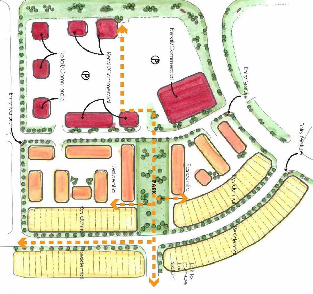
4 1.0 BACKGROUND The Pioneer Lands Area Structure Plan (ASP) was originally approved in February 2009 as Bylaw No. C to guide development of predominantly residential uses in the north portion of the annexation lands. An amendment to the ASP was approved on June 28, 2010 as Bylaw C This amendment reconfigured the collector road and land uses for Phase 1 of Greenbury. The approved development concept for the Pioneer Lands ASP is included as Exhibit Amendment This proposed amendment to the Pioneer Lands ASP continues to follow the vision and principles developed to create a smart-green community as approved in the ASP. The primary purpose of this new amendment is to create a plan for the area designated Special Study Area in the approved ASP. This area is intended to add a major commercial component to Spruce Grove that will provide a high profile destination for commercial and business activities. This prime location for commercial development will take advantage of high visibility from the Yellowhead Highway and will be integrated with residential and open space uses through the planned local pedestrian circulation system and local roads. Amendments to the Gateway Lands portion of the Pioneer Lands ASP include: addition of a mixed-use urban village. realignment of the collector roads; designation of residential land uses; reconfiguration of the stormwater management facilities; configuration of the open spaces; and addition of Gateway commercial uses. Additional amendments to the balance of the Pioneer Lands ASP include: redesignation of low density residential and mixed residential land uses to Level 1 (low to medium density residential); redesignation of medium and high density residential sites to Level 2 (medium to high density residential); reconfiguration of medium and high density residential uses; removal of several linear parks to provide consolidated open spaces with potential for schools or programmable spaces; realignment of Pioneer Road; adjustments to the proposed phasing plan to reflect changes in the sequence of development. AUGUST
5
6 2.0 LOCATION & CONTEXT The proposed amendments to the Pioneer Lands Area Structure Plan affect the lands designated as Special Study area in the approved ASP. These lands are located in the southeast corner of the intersection of Century Road and Yellowhead Trail (Highway 16). The highway is a major traffic thoroughfare that links Edmonton to Jasper providing high exposure of commercial uses to passing traffic. The Gateway Lands amendment area encompasses approximately 90 ha of land located north of the Spruce Village Neighbourhood. The secondary amendment encompasses NE ¼ , NW ¼ and SW ¼ These lands are located to the north and to the east of the first phase of development in Greenbury. An air photo of the amendment area is included as Exhibit 2 Aerial Photo. This photo was taken in September The adjacent Spruce Village neighbourhood is about 90% developed. Jubillee Park is located south and east of the Pioneer Lands and is developed as a regional park destination. Construction of the first phase of Greenbury in Pioneer Lands is underway with lots being registered and services currently being installed. Lands south of Grove Drive do not have an Area Structure Plan in place and remain in agricultural use or in a naturally wooded state. Lands to the east of the amendment area in the Parkland County and zoned AGR Agricultural Restricted. 2.1 Land Ownership IBI Group is applying for this amendment to the Pioneer Lands ASP on behalf of the participating owners and private developers of the land. AUGUST 2011 Page 2
7
8 3.0 POLICY CONTEXT This proposed ASP amendment describes the land uses, density of development, location of major roads and utilities and the proposed sequence of development in accordance with the City of Spruce Grove Area Structure Plan Guidelines. The ASP amendment adheres to the guidelines of the following bylaws and policies. 3.1 Municipal Development Plan The City s Municipal Development Plan Your Bright Future was approved as Bylaw C on July 12, The Gateway Lands ASP amendment corresponds with the following goals, objectives and policies of Section 5 Form and Infrastructure. Goal 5 Spruce Grove manages growth to ensure the city is economically, environmentally, and socially sustainable. The addition of the Gateway commercial and residential lands and associated infrastructure, will create employment and attract major highway commercial development in the City of Spruce Grove. Goal 6 Spruce Grove remains a compact, safe, and efficient community that emphasizes connectivity, accessibility, special places, and parks and open space and promotes a high standard of community design incorporating green and healthy living principles. The Gateway Lands will be developed as a special place in the City of Spruce Grove through development and application of design guidelines creating an attractive urban setting. The area will have a regional presence as a commercial and business centre. The Gateway Lands will be integrated with the surrounding residential neighbourhoods of Spruce Village and Pioneer Lands through linkages created by the collector road network and the local trail system of open spaces associated with the stormwater management facilities. Overall the Pioneer Lands hold a high standard for green development and healthy living principles. Sustainable measures include the use of bioswales for stormwater management, LED lighting and compact residential development. 5.4 Gateway Lands Develop the Gateway Lands as an integrated land use development which takes advantage of its strategic location on the Yellowhead TransCanada Highway while still considering local context and overall connectivity The commercial uses in the Gateway Lands will be oriented with signage that is clearly visible from Highway 16 and also from internal neighbourhood roads. This exposure will attract travellers on the Highway to enter Spruce Grove or to take note of what commercial uses are available for future visits. The location of Gateway Lands on the edge of the City is ideal because it will allow a large number of visitors to enter Spruce Grove without overburdening local roads in the interior of the City. AUGUST 2011 Page 3
9 Update the Pioneer Lands Area Structure Plan to include a concept plan and land use statistics for Gateway Lands which focuses on: integrated land use development; This amendment proposes a mix of commercial and residential uses that are complementary to one another and are integrated with controlled intersections and transitions where necessary. regional service and commercial uses; The Gateway Lands will provide a strong commercial presence in the region, providing services, office and retail uses. multi-modal transportation options and connectivity; The Gateway Lands are planned to be serviced by a regional transit hub providing a transit link to the City of Edmonton. The area is also well connected to the community through roads and multi-use trails. relationship with Jubilee Park and the surrounding residential neighbourhoods; Jubilee Park is planned to be well connected to Gateway Lands and surrounding residential by the pedestrian linkages and multi-use trails. innovative, compact, and high quality design. This amendment adds compact housing within the Mixed Residential and Mixed-Use land uses. The quality and innovation of these land uses will be showcased near a high traffic area accessing the commercial lands Include a community level gathering place, medium to high density residential development, and a regional park-and-ride for transit in Gateway Lands. A Mixed-Use site is proposed for Gateway Lands which will incorporate medium density residential with commercial retail development. The remaining residential lands will be mainly Level 1 low to medium density. This will provide a higher average density than conventional low density zones. A park site is proposed to act as a central meeting place for the urban village area. This park site will provide opportunities to retain a portion of the existing tree stand and for residents to gather in usable park space. Detail studies will be carried out to establish feasibility of retaining trees during subsequent planning stages. The Spruce Grove Transit system will service the area and there are preliminary plans for a transit facility and park and ride service. This park and ride will be part of the regional transit system that links to the City of Edmonton Incorporate a traffic analysis of Gateway Lands in the Transportation Master Plan to look at circulation and road/sidewalk capacity for private vehicles, transit, pedestrians, and cyclists and traffic calming strategies. A Traffic Impact Assessment is underway for The Gateway Lands. This assessment will confirm road widths and capacities proposed by the Area Structure Plan. The Gateway Lands ASP amendment corresponds with the following goals, objectives and policies of Section 6 Economic Development. AUGUST 2011 Page 4
10 Goal 7 Spruce Grove is affordable to residents and businesses, has a diverse tax base and offers a range of commercial services, light-to-medium industrial activities and employment options. Development of the Gateway Lands as a major commercial node with compact residential forms helps to address this goal. Increased affordability is achieved through increasing the tax base with revenues coming from commercial properties and higher density than conventional residential development. The commercial development in Gateway will also create employment in the shortterm in the form of construction activities, while development takes place and in the long-term as retail service, management and business employment opportunities. The prime location of the Gateway Lands along the Yellowhead Highway will attract upper echelon commercial developers looking to take advantage of the high exposure to continuous levels of commuter traffic on the Highway. Objective Increase local employment opportunities and municipal revenues through attraction, diversification, growth, and development of commercial and industrial businesses. Gateway Lands is anticipated to attract a diverse assortment of business and retail uses. These will create employment opportunities through construction activities and future business. Policies Designate sufficient land, at suitable locations, to provide for various types of commercial and industrial activities. Seventeen hectares of land are proposed as commercial use in Gateway Lands. This location is ideal for large lot commercial due to its high visibility from Yellowhead Trail and access off of Century Road. Policies Promote contiguous development of commercial and industrial areas and encourage infill and redevelopment of existing commercial and industrial areas. Commercial development at this location is contiguous as it is located at a major entrance to the City and is surrounded by existing residential. It will add to the growing business inventory in Spruce Grove. Policies Create a distinct identity for different areas and types of commercial and industrial park development through Land Use Bylaw regulations, Area Structure Plans, Area Redevelopment Plans, and community design guidelines. The Gateway Lands commercial will have a distinct identity by virtue of its high visibility and regional appeal as a commercial node. Unique themeing and architectural controls will be implemented through the Design Guidelines administered by the Developer and registered on title. Policies Promote appropriate increases to residential densities to support commercial development at a neighbourhood and city-wide level. The MDP states in that residential densities will be split into Level 1 and Level 2. Level 1 residential will provide opportunities for a mix of street oriented townhouses, duplex and singlefamily homes at a higher average density than conventional low density residential. Applying broader land use categories will allow greater flexibility in types of housing to be developed. AUGUST 2011 Page 5
11 Objective Enhance the gateway potential of Highway 16 and Highway 16A. The regional profile of the Century Road entrance from Highway 16 will be elevated significantly as Commercial amenities develop with high visibility from the highway. Policies Capitalize on the strategic location of Gateway Lands (Figure 8: Future Land Use) on the Yellowhead TransCanada Highway. Commercial buildings and signs will be oriented to provide high visibility and exposure to travellers on Highway 16. This location also has convenient access from the interchange at Century Road. Policies Work with Alberta Transportation to improve access to Spruce Grove from Highway 16 and upgrade existing interchanges to handle anticipated future traffic flows based on projected population growth in the region and the development of Gateway Lands. The developers of Gateway Lands are working with Alberta Transportation to accommodate the anticipated commercial and residential traffic. The plan respects the opportunity for potential Highway widening within the existing ROW and the noise attenuation berm required for Highway 16 (the entire berm will sit on private land). Objective Continue to develop Spruce Grove as a regional service and commercial centre. The Gateway Lands will elevate Spruce Grove s presence as a regional service and commercial centre through its high profile location and anticipated diversity of commercial businesses. Policies Develop Gateway Lands with a focus on regional service and commercial uses, integrated land use development, multi-modal transportation access, and innovative compact high quality design as discussed in 'Section Form and Infrastructure: Gateway Lands' that services primarily a regional base but also draws local users. The Gateway Lands will attract users from the region through its high visibility and convenient access opportunities. The area will be serviced by the Spruce Grove transit system and will include a transit facility and park and ride stalls. The local multi-use trail system will connect and traverse the commercial and mixed use areas of Gateway Lands, providing convenient access for local pedestrians and cyclists. Objective Provide opportunities for mixed use development to occur in the City Centre and the Urban Village and for integrated land use development to occur in Gateway Lands as identified on Figure 8: Future Land Use. The mixed residential housing will provide higher density than low density residential zoning and will access commercial uses through marked and signed crossings. A mixed use residential site is also proposed to accommodate a mix of commercial and residential uses creating an urban village atmosphere. AUGUST 2011 Page 6
12 Policies Apply high standards of community design to increase the pedestrian orientation and enhance the overall aesthetics of mixed use areas and integrated land use development areas, including: building orientation and presentation on the site; scale of buildings; site signage; site landscaping; site lighting; development relationship to the street; building facades; sidewalks/trail connections; informal seating areas; parking areas; and bus stops and/or hubs. The Gateway Lands will address community design through a set of design guidelines for the area that deal with the items listed above. A horizontal Mixed Use site is included in the Gateway Lands concept that will act as a focal point for the surrounding community incorporating community park space along the neighbourhood trail system. 3.2 Capital Region Growth Plan This amendment maintains the population and employment projections of the Capital Region Growth Plan. The neighbourhood projections overall maintain a minimum 25 units per net residential hectare. 3.3 The City of Spruce Grove Parks & Open Space Master Plan The City of Spruce Grove Parks and Open Space Master Plan was approved by Council on March 26, This document guides the development of parks, open space and recreation facilities in the City of Spruce Grove. This proposed amendment continues to follow the principles of the Open Space Master Plan. City administration has requested more school sites than identified in the Master Plan due to population increases and demographic changes in the City. This amendment addresses this need by reducing the number of linear parks and pocket parks and creating consolidated parcel of open space appropriate for school sites. AUGUST 2011 Page 7
13 3.4 The City of Spruce Grove Land Use Bylaw No. C The City of Spruce Grove Land Use Bylaw C contains zoning regulations and land use information for the City of Spruce Grove. The current zoning for the amendment area is AGR Agricultural Restricted. Residential districting for this area will use the new Mixed Residential District currently being implemented in the Greenbury area in Phase 1 of the ASP. This district allows a mix of row housing, single-detached and semi-detached building forms. Conventional zoning will be applied to the commercial land uses in the plan. The mixed-use parcel may require a new zone created to allow for a mix of residential and commercial uses on the site. Redistricting and subdivision applications will be submitted separately from this Amendment. AUGUST 2011 Page 8
14 4.0 DEVELOPMENT CONCEPT 4.1 Vision The vision for Gateway Lands is of a regional commercial center providing opportunities for shopping and employment, while integrating with a compact residential community to create vibrant streetscapes with convenient links to open space amenities. 4.2 Land Use Concept The proposed Land Use Concept for the amendment area is presented as Exhibit 3 and proposed Land Use and Population Statistics are presented as Exhibit 4. The following provides a brief description and rationale for the land use amendments proposed for the Pioneer Lands ASP RESIDENTIAL Proposed residential development comprises approximately 57% of the Gross Developable Area (GDA), with a planned yield of 4,427 units and a population of 12,942 residents. The overall mix of residential densities shall yield approximately 26 units per net residential hectare. The residential land uses for this amendment are updated to reflect the new MDP policy that states residential densities are split into two categories; Level 1 is a mix of low to medium densities. These may include single-family, semi-detached and row housing up to two and a half storeys in height. The average density for this level is 25 units per hectare. Level 2 residential is a mix of medium to high density residential including stacked row-housing, 4 storey walk-up apartments, and high-rise apartment buildings. These land use categories will be implemented through a new Land Use Bylaw that is currently in preparation. Immediate districting applications may propose the Mixed Residential Zone that was created and approved in the first phase of Greenbury, or other conventional zones within the Land Use Bylaw. The Area Structure Plan, when fully developed, is projected to provide approximately: 3,752 Low to Medium Density Units; 603 Medium to High Density Residential Units; 72 mixed-use residential units. Where appropriate, housing along collector roads will be oriented to address the street through the use of rear lanes. The intent is to create streetscapes that are inviting for pedestrians and motorists alike, creating a vibrant urban village atmosphere. This street-orientation provides visual interest for street users and surveillance by neighbours. AUGUST 2011 Page 9
15
16 Exhibit 4 Pioneer Lands ASP Amendment - Proposed Land Use Statistics Land Use GDA (ha) % of GDA Units/ha Units Pop/Unit Pop. Low to Medium Density Residential % , ,255 High Density Residential % ,508 Mixed-Use % Total Residential % ,427 12,942 Gateway Commercial % Neighbourhood Commercial % Parks and Recreation (MR)* % Stormwater Management Facilities % Local Roads % Collector Roads % Total Non Residential % Net Developable Area % Pipeline 1.24 Arterial Road (Grove Drive) 3.15 Total Area *The MR in Gateway Lands portion of the ASP was dedicated with the original subdivision. The 10% MR required for the remaining GDA in Pioneer Lands is 22 ha.
17 High to medium density residential sites have been reconfigured along Grove Drive. This amendment proposes moving a high density residential site to the southeast corner of the plan with close access to the arterial road. The market today does not favour high density residential at the current approved location, which makes it difficult to move to the next stage of development. Moving the high density to a later phase will allow for timely development of lands within the ASP without reducing the overall densities in the Neighbourhood COMMERCIAL The Gateway Lands are planned to act as a regional destination point for consumers and to provide convenient access to a variety of commercial and business uses. The high visibility of the lots along Highway 16 will help boost Spruce Grove s regional appeal as a business and shopping destination. The area will act as a major employment node, reducing commute times for people living in Spruce Grove that may have alternatively driven to Edmonton for work. The exposure of these lots will attract motorists that may have otherwise passed by Spruce Grove on the way to their intended destination. These commercial lots will have access off of the main collector road proposed for the Gateway Lands, with an internal circulation and parking network that provides convenient access to retail and businesses. The intensity of commercial development is planned to increase from east to west with potential uses including vehicle sales, offices, hotels, restaurants, financial services, retail stores, etc. The southwest parcel of commercial lands located on Century Road may be the first phase of commercial development. This site will provide retail and services for local residents and will be integrated as a mixed-use development creating an urban village feature for the neighbourhood. The commercial areas will be accessible by the regional bus transit system, providing a convenient alternate means for citizens to travel to work or to go shopping. The commercial area will also be well serviced by the neighbourhood walkway system providing safe and convenient links for pedestrians and cyclists. Clear signage and architectural elements will be used on both the highway side and the internal neighbourhood side of commercial buildings to maximize exposure to consumers MIXED USE URBAN VILLAGE A mixed-use urban village node is proposed as part of the innovation that is planned to attract new people to Spruce Grove. This mixed use site measures 4 hectares and accommodates a horizontal mix of retail and residential uses. A concept plan for the mixed-use area is included in Exhibit 5. AUGUST 2011 Page 10
18
19 Location & Context The mixed-use urban village is to be located between the two proposed collector road entrances from Century Road with high visibility from traffic entering the neighbourhood from the west. The planned mixed-use urban village area is strategically located to provide a focal point of interest and entry feature to the Gateway Lands community. This site will provide the first impression to visitors as they enter Pioneer Lands and through the application of themes and architectural features, the site will create a sense of place that residents of Pioneer Lands and Spruce Grove will identify with. The mixed-use village is grouped in close proximity to key regional amenity areas including the planned Gateway commercial area with exposure to the highway and the regional open space Jubilee Park. These features are key attractors to Pioneer Lands and along with the urban village node, will help to ensure each other s viability through drawing high levels of interest within Spruce Grove and the larger region Integration & Connectivity With horizontal mixed-use developments, commercial and residential buildings are located separately, but in close proximity to one another. This arrangement of uses is desirable to reduce the potential for conflicts between users, such as, parking access and loading zones, while providing residents retail within walking distance and supplying retailers a local supply of consumers and employees. In Gateway, a complimentary relationship between retail and residential uses will create opportunities to work and live within a compact community. The location of the urban village allows for connection to the community walkway system allowing for seamless integration with the surrounding residential community of Pioneer Lands and Spruce Village. Commercial and residential areas will be linked through shared amenity spaces and integrated with surrounding residential through a comprehensive pedestrian circulation system. The site will be designed to encourage pedestrian interaction along efficient pedestrian walkways and connections. This will help create a walkable site with a vibrant street life. The mix of uses within a compact area helps to ensure the continuous use of public spaces throughout the day. While many residents are away at work during the day, consumers and employees will continue to frequent public spaces. This shall create a continuous passive surveillance system and promote a sense of security and belonging among residents Streetscape The mixed-use site will have a pedestrian scale street presence with units fronting on to Vanderbilt Common, the internal main street, and the north/south collector road. The site will have status as an innovative and attractive development where residents, employees, and consumers interact within vibrant and active urban spaces. The streetscape will be enhanced through application of a unifying theme and implementation of architectural design guidelines. Specific size, shape, and orientation of residential uses will be determined at zoning and development permit through discussions with City staff. During warm seasons, the streetscape may be further stimulated by restaurants and cafés that provide patios where patrons can meet, visit and relax as active participants in the urban landscape. AUGUST 2011 Page 11
20 Sustainability The compact mix of uses proposed, reduces the need for personal vehicles and encourages a healthy lifestyle where walking is the primary mode of transportation. The mixed-use site is located along the multi-use circulation system, providing convenient access to retail and services for local pedestrians and cyclists. A central park site may have the opportunity to retain some of the existing trees, creating a natural focal point and meeting place for residents of the area. Additional studies to determine the feasibility of returning trees will be carried out in later planning stages. This park site will be visible from the north/south collector road and will link the commercial amenities to the rest of the Pioneer Lands community Urban Design High quality urban design for the development will be addressed through the provision of integrated walkways, preservation of treed areas within public open space and private yards, visually interesting streetscapes, and integration of stormwater management facilities into the community as open space amenities. Architectural guidelines will be established for the area providing a unifying theme through establishment of standards for landscape, architecture, signage and accessibility. Theming for the Gateway Lands reinforced by street names and complementary architectural design regulations will help to establish the area as an attractive and desirable place to work, live and play. The following table lists urban design concepts and how they will be applied to Gateway Lands. Urban Village Design Guidelines Concept Guideline Application within Gateway Connectivity Integration Provide convenient links for pedestrians, cyclists, motorists, and transit users between neighbourhood focal points and amenities. Integrate the internal uses in a complementary fashion. Provide accesses around the perimeter of the urban village with clear distinction between internal roads and walkways. Provide several opportunities for pedestrian and vehicular access to the site at regular intervals from the surrounding roadways. Provide connections from the community and to/from neighbourhood amenities and focal points with greenways, multi-use trails, or sidewalks. An internal main street will be developed where commercial and residential uses will interface. AUGUST 2011 Page 12
21 Concept Guideline Application within Gateway Connections between residential and commercial uses will be accommodated through marked pedestrian crossings. Orient buildings to maximize active use of the public spaces, such as locating outdoor patios for restaurants and cafes near main thoroughfares. Integrate commercial and mixed uses with the surrounding community. The surrounding community will have strong multi-use linkages and greenways providing attractive and convenient links between neighbourhood amenities and focal points. Sense of Place Use appropriate signage to clearly identify uses within the urban village. Incorporate 360 degree facades for retail where access is provided from internal parking areas and buildings address the public street. Opportunities for reverse housing where houses front onto greenways will be explored at more detailed levels of planning. Multi-use linkages are provided through linear ponds, linear greenways, and in some cases along major street linkages to connect neighbourhood amenities, such as, the Gateway commercial area, the mixed use urban village, Jubilee Park, future potential school sites, and open space opportunities. Integrate signage into the architecture of buildings. Use signage that is clearly visible at pedestrian and AUGUST 2011 Page 13
22 Concept Guideline Application within Gateway vehicular scale. Place signage perpendicular to shop fronts at a pedestrian scale. Avoid visual clutter from signs. Use entry features to give names to areas. Apply a unique architectural theme for the urban village to enhance a sense of place. An architectural and landscape theme for the mixed use urban village will be described and implemented through architectural design guidelines. Arrangement of Internal Uses Reduce the impacts of incompatible uses. Landmarks shall be located at strategic points on the site to enhance local place making. Arrange and buffer residential areas and public gathering spaces from high traffic areas and incompatible uses to reduce the impact of noise and visual irritants. Orient commercial loading zones away from residential uses, outdoor patios and public open spaces. Use landscape and fencing to screen waste disposal and storage areas from sight lines of residential areas and pedestrian walkways. Use buffers or specialized technical applications, such as, double glazed windows to reduce noise levels where optimal layout of noise sources cannot be achieved. In horizontal mixed use developments, residential and commercial uses will be separated by internal circulation systems and landscape features. AUGUST 2011 Page 14
23 Concept Guideline Application within Gateway Separate parking areas and accesses for residential and commercial uses will be provided. Arrange residential uses to back on to the north collector road, which will accommodate high levels of commercial and neighbourhood traffic. Parking Streetscape Parking areas are designed to be efficient, unobtrusive and complementary to surrounding uses. Arrange buildings to provide an attractive and secure urban environment for pedestrians. Commercial and residential uses will have separate parking areas. Commercial and residential uses will have separate accesses to parking areas. Designated pedestrian links from parking areas to residential or commercial buildings will be provided. Parking lot promenades will be strategically located and enhanced with landscaping to provide convenient links to commercial uses. Where appropriate, orient buildings to front onto the collector and local roads. Provide higher density streetoriented residential product along the collector roads with vehicle access from back lanes. Plan for higher density residential within and adjacent to the mixed-use urban village. Explore options for innovative housing and architecture to provide visual interest to pedestrians and motorists. Provide ground floor facades AUGUST 2011 Page 15
24 Concept Guideline Application within Gateway that are rich in detail and provide interest for pedestrians. Provide a variety of facades for residential units fronting onto the street. Arrange landscaping in an attractive and complementary manner. Provide outdoor seating where appropriate. Provide adequate lighting using efficient technologies to illuminate dark areas creating an inviting atmosphere. Clearly identify primary entrances through the use of canopies, awnings, porches, architectural features, display windows, signage, planters and other design features. Design entrances to be well-lit at night with clear address numbering. Sustainability Encourage a sustainable and environmentally friendly community through the use of environmentally friendly technologies and sustainable design. Explore the use of environmentally friendly technologies for lighting, construction materials, landscaping, water usage, and stormwater drainage. Where possible, orient buildings and windows to take advantage of winter sun and summer shade through passive solar design. Design buildings with flexibility to change uses adapting to market trends. Provide a range of services and residential forms to accommodate different age groups and allow for residents to remain in Pioneer Lands throughout different stages of AUGUST 2011 Page 16
25 Concept Guideline Application within Gateway their life cycle. Minimize waste during construction activities. Incorporate existing vegetation into site design TRANSIT STATION The City is contemplating a transit station that includes park-and-ride parking stalls. The transit facility site will measure approximately 2 acres and will service the regional transit system with links to Edmonton and Stony Plain. The most likely location for the transit facility will be within the commercial area. This location will be determined at more detailed levels of planning as commercial sites are laid out. Gateway commercial area will be a big attraction to commuters, and will act as a hub for employees, residents and consumers throughout the day OPEN SPACE The parcels in the Gateway Lands area have already paid the 10% of Gross Developable Area Municipal Reserve dedication with the original subdivision of the lands. Park spaces have been reoriented to respond to the City requirement of more consolidated park spaces accommodating future school sites and programmable space. A linear greenway has been added to the Gateway Lands to promote strong pedestrian connection from residential areas to the mixed-use site and commercial lands. Where possible, existing trees should be retained within park spaces and the trail system within the Gateway Lands, creating natural settings with mature trees. The open spaces proposed are consistent with the City of Spruce Grove Parks and Open Space Master Plan, which defines seven categories of open space. The open spaces planned to be included in the Gateway Lands fall under category E. Type E parks are classified as linear systems, green corridors, paths, and streets. The types of park in the Pioneer Lands ASP are identified in Exhibit 6 - Transportation, Parks, & Open Space. Overall, the amount of park to be dedicated as Municipal Reserve in the ASP is 22.5 ha, accounting for 10% of the Gross Developable Area. The amount of park space planned for Gateway Lands is 0.89 ha. This is included in the 10% overall land dedication for Pioneer Lands ASP TRANSPORTATION SYSTEM Collector roads are designed to provide efficient movement for local traffic and wider right-of-ways for services and transit routes. The collector roads are planned as standard Spruce Grove cross-sections. AUGUST 2011 Page 17
26
27 The major collector road provides access from Century Road with additional width for turn bays to access the commercial lands. This road will provide access to the commercial sites and their internal parking and circulation system. The collector connects Century Road to Pioneer Drive. Vanderbuilt Common will continue to provide access to Spruce Village from Century Road at the neighbourhood s west access, but will not extend through to Pioneer Road. This east/west extension of the collector was found to be unnecessary in the Traffic Impact Assessment. Removing this extension will cut down on exposure of housing to collector level traffic by turning the road north and creating a connection to the main collector road. A bend has been added to Pioneer Road, east of Greenbury. This bend crates a more interesting streetscape and will allow for more logical layout of local roads and lotting within Greenbury. AUGUST 2011 Page 18
28 5.0 SERVICING The servicing concepts are graphically presented in Exhibit Water Water services will follow the alignment of the collector roads in the amendment area and connect to existing services in Spruce Village. 5.2 Stormwater Drainage The stormwater management facilities are designed to accommodate a 100 year storm event. The linear storm pond in the northwest corner is configured to run along the north boundary of the neighbourhood. This pond will provide an amenity space with a multi-use trail extending along the planned commercial area. This trail will link commercial uses to the internal walkway system and to the walkway on Century Road. There is an existing unnamed creek in the southeast portion of the plan in SW ¼ This creek will be retained in accordance with the Water Act and Public Lands Act Alberta legislation. The details of the stormwater management system will be included in the Stormwater Management Plan and planned through coordination with the City of Spruce Grove, Alberta Environment, and Alberta Sustainable Resources Development. 5.3 Sanitary As shown in Exhibit 7, the direction of sanitary flow in Gateway Lands will be split. One sanitary trunk extends west in the major collector road and outlets to the north. A second sanitary trunk extends east to connect to a major sanitary trunk also extending north. 5.4 Noise Attenuation A noise attenuation study was performed with the original Pioneer Lands ASP. It recommends a berm and noise attenuation fence, planned along Highway 16 at the north boundary of the neighbourhood. This berm will reduce traffic noise for the residential portions of Pioneer Lands along the highway. The berm and fence end where commercial uses are planned to begin. This will ensure that passing motorists on the highway will have clear visibility to the commercial business. AUGUST 2011 Page 19
29
30 6.0 PHASING The Gateway Lands are scheduled to begin development in Fall The proposed Phasing Plan is included as Exhibit 8. The southwest parcel of commercial in Gateway Lands is likely the first phase of commercial development, providing retail and services for local residents. Residential development will likely progress east from Greenbury, proceeding in a logical sequence of infrastructure construction. AUGUST 2011 Page 20
31
32 7.0 IMPLEMENTATION The proposed plan will be implemented through applications for redistricting and subdivision as per the City of Spruce Grove standards. J:\pre-integration\old_H\Planning\12513 Pioneer Lands\Reports\ASP\Gateway\PTR _pioneer-lands-gateway-ASP-r16_ doc\ \JLB AUGUST 2011 Page 21
Westwind Developments Ltd. PIONEER LANDS AREA STRUCTURE PLAN - PROPOSED AMENDMENT
 FEBRUARY 2013 TABLE OF CONTENTS 1.0 BACKGROUND... 1 1.1 Amendment... 1 2.0 LOCATION & CONTEXT... 2 2.1 Land Ownership... 2 3.0 POLICY CONTEXT... 3 3.1 Municipal Development Plan... 3 3.2 Capital Region
THE CITY OF SPRUCE GROVE BYLAW C PIONEER LANDS AREA STRUCTURE PLAN AMENDMENT
 THE CITY OF SPRUCE GROVE BYLAW C-932-15 PIONEER LANDS AREA STRUCTURE PLAN AMENDMENT WHEREAS, pursuant to the Municipal Government Act, R.S.A. 2000, c. M-26, including amendments, a municipality may adopt
Bylaw No. B-03/2011 Adopted by Airdrie City Council February 21, 2012
 COOPER S CROSSING STAGE 4 Neighbourhood Structure Plan City of Airdrie WESTMARK HOLDINGS LTD. Bylaw No. B-03/2011 Adopted by Airdrie City Council February 21, 2012 CONSULTANTS: LAND USE PLANNING: Southwell
East Bayshore Road Neighbourhood
 East Bayshore Road Neighbourhood Northridge Property Management Urban Design Brief 3195 East Bayshore Road City of Owen Sound January 2016 East Bayshore Road Neighbourhood Northridge Property Management
URBAN DESIGN BRIEF URBAN DESIGN BRIEF 721 FRANKLIN BLVD, CAMBRIDGE August 2018
 URBAN DESIGN BRIEF URBAN DESIGN BRIEF 721 FRANKLIN BLVD, CAMBRIDGE August 2018 DESIGN BRIEF CONTENTS PART A 1.0 INTRODUCTION 2.0 DESCRIPTION & ANALYSIS OF SITE CONTEXT 3.0 DESIGN CONSTRAINTS AND OPPORTUNITIES
Chappelle Neighbourhood Area Structure Plan
 Chappelle Neighbourhood Area Structure Plan Office Consolidation September 2017 Prepared by: City Planning Urban Form and Corporate Strategic Development City of Edmonton Bylaw 14779 was adopted by Council
Stewart Greens Neighbourhood Structure Plan
 Stewart Greens Neighbourhood Structure Plan Office Consolidation June 2017 Prepared by: Planning and Policy Services Branch Planning and Development Department City of Edmonton Bylaw 14674, as amended,
Clairtrell Area Context Plan
 Clairtrell Area Context Plan March 2005 Urban Development Services City Planning Contents 1. Introduction... 4 2. Development Structure... 6 2.1 Streets... 7 2.1.1 Sheppard Avenue and Bayview Avenue...
Bylaw C-1186 Adopted November 5, Planning and Development Services
 Bylaw C-1186 Adopted November 5, 2007 Planning and Development Services CITY OF GRANDE PRAIRIE OFFICE CONSOLIDATION BYLAW C-1186 A Bylaw to adopt the Westgate Area Structure Plan (As Amended by Bylaw C-1186-1,
City of Grande Prairie Development Services Department
 City of Grande Prairie Development Services Department ROYAL OAKS NORTH OUTLINE PLAN OP-07-03 NW 35-71-6 W6M May 7, 2007 Royal Oaks North Outline Plan TABLE OF CONTENTS 1.0 INTRODUCTION........ 3 1.1 Purpose
Regency Developments. Urban Design Brief. Holyrood DC2 Rezoning
 Regency Developments Urban Design Brief Holyrood DC2 Rezoning Stantec Consulting Ltd. 7-31-2017 1. Overview Regency Developments intends to rezone the lands located at 8510 and 8511 93 Avenue, within the
Land Use Amendment in Southwood (Ward 11) at and Elbow Drive SW, LOC
 at and Elbow Drive SW, LOC") 2018 November 15 Page 1 of 10 EXECUTIVE SUMMARY This land use amendment application was submitted by Rick Balbi Architect on 2017 August 31 on behalf of Sable Developments Ltd, and with authorization from
2018 November 15 Page 1 of 10 EXECUTIVE SUMMARY This land use amendment application was submitted by Rick Balbi Architect on 2017 August 31 on behalf of Sable Developments Ltd, and with authorization from
Complete Neighbourhood Guidelines Review Tool
 Complete Neighbourhood Guidelines Review Tool Prepared By: City of Regina Planning Department October 2014 Page 1 of 14 Community Development Review Checklist for Secondary Plans and Concept Plans The
OP Council Resolution June 16, Planning and Development Services
 OP-08-01 Council Resolution June 16, 2008 Planning and Development Services Kingsgate Landing Outline Plan Table of Contents 1.0 Introduction 1 1.1 Purpose of Plan 1 1.2 Plan Area Location 1 1.3 Ownership
*** DRAFT 2 FOR PUBLIC REVIEW ***
 6.7 The area is generally bounded by the Red Hill Valley Parkway to the west, Lake Avenue to the east, the Queen Elizabeth Way (QEW) to the north, and by the properties just south of Queenston Road to
5.1 Site Plan Guidelines
 5. Community Core Guidelines Development of the Community Core will take place by plan of subdivision and site plan approval. It will occur in a phased manner that will reflect the timing of residential
Outline Plan in Belvedere (Ward 9) at Street SE, LOC (OP)
 at Street SE, LOC (OP)") 2018 October 04 Page 1 of 12 EXECUTIVE SUMMARY This outline plan application was submitted by B&A Planning Group on 2016 July 15, on behalf of Tristar Communities Inc. for 50.14 hectares (123.89 acres)
2018 October 04 Page 1 of 12 EXECUTIVE SUMMARY This outline plan application was submitted by B&A Planning Group on 2016 July 15, on behalf of Tristar Communities Inc. for 50.14 hectares (123.89 acres)
FORMER CANADIAN FORCES BASE (CFB) ROCKCLIFFE SECONDARY PLAN. Official Plan Amendment XX to the Official Plan for the City of Ottawa
 ROCKCLIFFE SECONDARY PLAN. Official Plan Amendment XX to the Official Plan for the City of Ottawa") FORMER CANADIAN FORCES BASE (CFB) ROCKCLIFFE SECONDARY PLAN Official Plan Amendment XX to the Official Plan for the City of Ottawa 1 INDEX THE STATEMENT OF COMPONENTS PART A THE PREAMBLE PAGE Purpose...
FORMER CANADIAN FORCES BASE (CFB) ROCKCLIFFE SECONDARY PLAN Official Plan Amendment XX to the Official Plan for the City of Ottawa 1 INDEX THE STATEMENT OF COMPONENTS PART A THE PREAMBLE PAGE Purpose...
FUTURE LAND USE ELEMENT
 FUTURE LAND USE ELEMENT GOAL I: To create and sustain a great place to live, play, and prosper Objective 1: The City of Ocala shall incorporate the principles and strategies of the Ocala 2035 Vision into
URBAN DESIGN BRIEF. 2136&2148 Trafalgar Road. Town of Oakville
 URBAN DESIGN BRIEF 2136&2148 Trafalgar Road Town of Oakville Prepared By: METROPOLITAN CONSULTING INC For 2500674 Ontario Inc November 2016 TABLE OF CONTENTS Page No. 1.0 Introduction/Description of Subject
ADMINISTRATION RECOMMENDATION 2016 November 03. That Calgary Planning Commission recommends APPROVAL of the proposed Land Use Amendment.
 Page 1 of 12 EXECUTIVE SUMMARY This Land Use Amendment application covers an area of 75.76 hectares ± (187.20 acres ±) located in northeast Calgary, bound by Stoney Trail NE to the north, 128 Avenue NE
The transportation system in a community is an
 7 TRANSPORTATION The transportation system in a community is an important factor contributing to the quality of life of the residents. Without a sound transportation system to bring both goods and patrons
LAND USE AMENDMENT CORNERSTONE (WARD 3) COUNTRY HILLS BOULEVARD AND STONEY TRAIL NE BYLAW 9D2017
 COUNTRY HILLS BOULEVARD AND STONEY TRAIL NE BYLAW 9D2017") Page 1 of 12 EXECUTIVE SUMMARY This Land Use Amendment application covers an area of 54.92 hectares ± (135.71 acres ±) located in northeast Calgary, bound by Country Hills Boulevard NE to the north and
Page 1 of 12 EXECUTIVE SUMMARY This Land Use Amendment application covers an area of 54.92 hectares ± (135.71 acres ±) located in northeast Calgary, bound by Country Hills Boulevard NE to the north and
North Oakville East Parks Facilities Distribution Plan. November, 2009
 North Oakville East November, 2009 POLICY CONTEXT 1) Purpose a) The purpose of this document is to be a guide for the location, configuration, design and development of the parks system for the North Oakville
DRAFT Northeast Quadrant of Kipling Avenue and Highway 7 DRAFT AUGUST 29, Goals Land Use. The goals of this Plan are to:
 AUGUST 29, 2017 12.15 Northeast Quadrant of Kipling Avenue and Highway 7 12.15.1 Goals 12.15.2 Land Use The goals of this Plan are to: 12.15.2.1 General Provisions: a) Ensure the development of a compact
4. INDUSTRIAL 53 CASTLE ROCK DESIGN
 4. INDUSTRIAL 53 CASTLE ROCK DESIGN CASTLE ROCK DESIGN 54 4. INDUSTRIAL Overview Well-designed and attractive industrial centers are the product of blending economic realities with both functional and
CONTENTS 8.0 LAND USE 8.1 GENERAL LAND USE 8.2 RESIDENTIAL 8.3 MIXED USE 8.4 COMMERCIAL 8.5 EMPLOYMENT LANDS
 8-2 Land Use 8.0 LAND USE CONTENTS 8.1 GENERAL LAND USE 8.1.1 Uses provided for in all Land Use Designations 8.1.2 Uses prohibited in Hazardous Lands, Hazardous Sites and Special Policy Areas 8.1.3 Uses
[PLANNING RATIONALE] For Site Plan Control and Lifting of Holding Zone By-Law 101 Champagne Avenue. May 23, 2014
![[PLANNING RATIONALE] For Site Plan Control and Lifting of Holding Zone By-Law 101 Champagne Avenue. May 23, 2014](/thumbs/75/71599615.jpg "[PLANNING RATIONALE] For Site Plan Control and Lifting of Holding Zone By-Law 101 Champagne Avenue. May 23, 2014") [PLANNING RATIONALE] For Site Plan Control and Lifting of Holding Zone By-Law 101 Champagne Avenue May 23, 2014 Contents 1.0 Introduction... 2 2.0 Site Context... 2 2.1 Adjacent Uses... 2 Figure 1: Site
[PLANNING RATIONALE] For Site Plan Control and Lifting of Holding Zone By-Law 101 Champagne Avenue May 23, 2014 Contents 1.0 Introduction... 2 2.0 Site Context... 2 2.1 Adjacent Uses... 2 Figure 1: Site
GATEWAY AREA STRUCTURE PLAN
 CHESTERMERE GATEWAY AREA STRUCTURE PLAN COMMUNITY OPEN HOUSE SEPTEMBER 22 nd, 2015 PLAN AREA ± 512 hectares (± 1,265 acres) GATEWAY LOCATION UNDEVELOPED LANDS PRESENT AGRICULTURAL USE REGIONAL LAND USE
Urban Design Brief Proposed Residential Development 5219 Upper Middle Road City of Burlington
 Urban Design Brief Proposed Residential Development 5219 Upper Middle Road City of Burlington Prepared by Weston Consulting Prepared for BLOOMFIELD DEVELOPMENT INC. Date: March 2017 Table of Contents 1.
PORT WHITBY COMMUNITY
 PORT WHITBY COMMUNITY SECONDARY PLAN UPDATE COMMUNITY IMPROVEMENT PLAN URBAN DESIGN GUIDELINES September 2015 DRAFT PROPOSED AMENDMENT NUMBER # to the Whitby Official Plan PURPOSE: The intent of this Amendment
ELMVALE ACRES SHOPPING CENTRE MASTER PLAN
 ELMVALE ACRES SHOPPING CENTRE MASTER PLAN Contents 1.0 INTRODUCTION... 2 2.0 LOCATION... 2 3.0 EXISTING CONTEXT... 2 4.0 VISION & GUIDING PRINCIPLES... 2 5.0 LAND USE AND BUILT FORM... 4 5.1 St. Laurent
LAND USE AMENDMENT CORNERSTONE (WARD 3) 60 STREET NE AND COUNTRY HILLS BOULEVARD NE MAP 26NE BYLAW 22D2017
 60 STREET NE AND COUNTRY HILLS BOULEVARD NE MAP 26NE BYLAW 22D2017") Page 1 of 14 EXECUTIVE SUMMARY This Land Use Amendment application covers an area of 43.76 hectares ± (108.14 acres ±) located in northeast Calgary, bound by Country Hills Boulevard NE to the south and
Page 1 of 14 EXECUTIVE SUMMARY This Land Use Amendment application covers an area of 43.76 hectares ± (108.14 acres ±) located in northeast Calgary, bound by Country Hills Boulevard NE to the south and
Bel-Air Lexus Automobile Service Station
 Bel-Air Lexus Automobile Service Station Design Brief 443-447 McArthur Avenue Ottawa April 30, 2015 14-1299-MCA Site Details Application: Site Plan Control Legal Description and Municipal Addresses: 443
ROAD CLOSURE AND LAND USE AMENDMENT SILVER SPRINGS (WARD 1) NORTHEAST OF NOSEHILL DRIVE NW AND SILVER SPRINGS ROAD NW BYLAWS 2C2018 AND 29D2018
 NORTHEAST OF NOSEHILL DRIVE NW AND SILVER SPRINGS ROAD NW BYLAWS 2C2018 AND 29D2018") Page 1 of 19 EXECUTIVE SUMMARY This application proposes redesignating two parcels in the community of Silver Springs from Special Purpose Future Urban Development (S-FUD) District and undesignated road
Page 1 of 19 EXECUTIVE SUMMARY This application proposes redesignating two parcels in the community of Silver Springs from Special Purpose Future Urban Development (S-FUD) District and undesignated road
Bylaw C-1262 Adopted February 6, Planning and Development Department
 Bylaw C-1262 Adopted February 6, 2012 Planning and Development Department CITY OF GRANDE PRAIRIE BYLAW C-1262 A Bylaw to adopt the Brookfield Neighbourhood Outline Plan THE MUNICIPAL COUNCIL OF THE CITY
Lehigh Acres Land Development Regulations Community Planning Project
 Lehigh Acres Land Development Regulations Planning Effort Summary In July, 2010 Commissioner Frank Mann invited the Lehigh Acres community to start discussing how to achieve their recently adopted community
1.4 TRANSIT VISION 2040 FROM VISION TO ACTION THEME 1: PUTTING TRANSIT AT THE CENTRE OF COMMUNITIES. Fully integrate transit with community design
 TRANSIT VISION 2040 FROM VISION TO ACTION TRANSIT VISION 2040 defines a future in which public transit maximizes its contribution to quality of life with benefits that support a vibrant and equitable society,
WINTERBURN INDUSTRIAL AREA STRUCTURE PLAN
 OCTOBER 2009 Winterburn Industrial Area Structure Plan Office Consolidation November 2012 Prepared by: Current Planning Branch Sustainable Development City of Edmonton Bylaw 15356, was adopted by Council
and services The protection and conservation of environmentally significant and sensitive natural heritage features and functions.
 6. Land Use 6.0 Preamble A healthy and livable city is one in which people can enjoy a vibrant economy and a sustainable healthy environment in safe, caring and diverse neighbourhoods. In order to ensure
(DC1) Direct Development Control Provision DC1 Area 4
 Direct Development Control Provision DC1 Area 4") . General Purpose (DC) Direct Development Control Provision DC Area 4 The purpose of this Provision is to provide for an area of commercial office employment and residential development in support of the
. General Purpose (DC) Direct Development Control Provision DC Area 4 The purpose of this Provision is to provide for an area of commercial office employment and residential development in support of the
Corridor Transformation Strategy
 Corridor Transformation Strategy County Road 22 Special Planning Area Design Guidelines January 2012 D14-06017 Corridor Transformation Strategy County Road 22 Special Planning Area Corridor Design Guidelines
Cit of Kitchener Ur 6 an Design Manual PARTA. Desi n for _--::
 Cit of Kitchener Ur 6 an Design Manual Date PARTA Year ) Desi n for k Nodes Corridors _--:: Section Page 01 of 12 2 INTRODUCTION Purpose & Application Nodes and Corridors have been identified as key intensification
Ebbers Neighbourhood Area Structure Plan
 Ebbers Neighbourhood Area Structure Plan Office Consolidation November 2016 Prepared by: City Planning Branch Sustainable Development City of Edmonton Bylaw 14079, was adopted by Council in February 2006.
PUBLIC RIGHT-OF-WAY IN THIS CHAPTER PUBLIC REALM
 PUBLIC RIGHT-OF-WAY This section provides design guidelines for improvements in the public right-of-way. The public right-of-way refers to streets, sidewalks, non-vehicular thoroughfares, parks and greenways
URBAN DESIGN BRIEF 181 Burloak Drive, Oakville
 URBAN DESIGN BRIEF 181 Burloak Drive, Oakville February 2017 Our File: 1730B 230-7050 WESTON ROAD / WOODBRIDGE / ONTARIO / L4L 8G7 / T: 905 761 5588/ F: 905 761 5589/WWW.MHBCPLAN.COM TABLE OF CONTENTS
This application has been applied for with support of an Outline Plan to provide the technical details for the site s development.
 Page 1 of 13 EXECUTIVE SUMMARY This application consists of a Land Use Amendment application proposing redesignation from Special Purpose Future Urban Development (S-FUD) District to an assortment of multiresidential,
Sierra Springs Regional Commercial Master Site Plan Airdrie, Alberta Hopewell Development Corporation Project No May 26, 2010
 Sierra Springs Regional Commercial Master Site Plan Airdrie, Alberta Hopewell Development Corporation Project No. 205-077 May 26, 2010 TABLE OF CONTENTS Purpose... 2 Master Site Plan Guidelines... 3 Overall
CHAPTER 7: Transportation, Mobility and Circulation
 AGLE AREA COMMUNITY Plan CHAPTER 7 CHAPTER 7: Transportation, Mobility and Circulation Transportation, Mobility and Circulation The purpose of the Transportation, Mobility and Circulation Chapter is to
Red Fox Commercial Outline Plan
 Red Fox Commercial Outline Plan City of Cold Lake, Alberta Prepared by Durrance Projects Ltd and Ross W. Sharp & Associates Ltd October 2014 Rupert 1 Table of Contents 1. PURPOSE...3 1.1. Location...4
Urban Design Manual PLANNING AROUND RAPID TRANSIT STATIONS (PARTS) Introduction. Station Study Areas
 Introduction. Station Study Areas") 111111 PLANNING AROUND RAPID TRANSIT STATIONS (PARTS) Introduction The ION rapid transit system will link Waterloo, Kitchener and Cambridge through a central transit corridor (CTC). There are a number
111111 PLANNING AROUND RAPID TRANSIT STATIONS (PARTS) Introduction The ION rapid transit system will link Waterloo, Kitchener and Cambridge through a central transit corridor (CTC). There are a number
Trafalgar Road Corridor Planning Study Open House
 Trafalgar Road Corridor Planning Study Open House June 24, 2013 6:30-8:30 p.m. Oakville & Trafalgar Rooms Overview The Livable Oakville Plan identifies the lands along Trafalgar Road, between the QEW and
THE CITY OF VAUGHAN BY-LAW BY-LAW NUMBER A By-law to adopt Amendment Number 1 to the Official Plan of the Vaughan Planning Area.
 THE CITY OF VAUGHAN BY-LAW BY-LAW NUMBER 015-2014 A By-law to adopt Amendment Number 1 to the Official Plan of the Vaughan Planning Area. NOW THEREFORE the Council of the Corporation of the City of Vaughan
Urban Design Brief Fanshawe Park Road. Competition Toyota
 Urban Design Brief 1300 Fanshawe Park Road Competition Toyota May 2, 2014 TABLE OF CONTENTS Page No. INTRODUCTION... 1 SECTION 1 LAND USE PLANNING CONTEXT... 1 1.1 The Subject Lands... 1 1.2 The Proposal...
Gateway commercial MIXED USE MASTER SITE PLAN. CITILAND AIrDRIE GATEWAY VENTURE INC. airdrie GATEWAY COMMERCE CENTRE. airdrie, ALBERTA FEBRUARY 2012
 Gateway commercial MIXED USE MASTER SITE PLAN 1914 CENTRE STREET NORTH CALGARY, AB CANADA T2E 2S8 T. 403.264.7177 F. 403.264-7175 WWW.CITILAND.CA CITILAND AIrDRIE GATEWAY VENTURE INC. airdrie GATEWAY COMMERCE
This Review Is Divided Into Two Phases:
 Semiahmoo Town Centre Review The purpose of this review: To review the Semiahmoo Town Centre Concept Plan, originally approved in 1993, to ensure that this centre will continue to serve the needs of South
4.1.3 LAND USE CATEGORIES
 4.1.3 LAND USE CATEGORIES a. City Center District The City Center District incorporates the existing character and mix of uses in downtown Belmont to encourage redevelopment and new development in keeping
ADMINISTRATION RECOMMENDATION(S) 2018 January 25. That Calgary Planning Commission recommend APPROVAL of the proposed Land Use Amendment.
 2018 January 25. That Calgary Planning Commission recommend APPROVAL of the proposed Land Use Amendment.") Page 1 of 9 EXECUTIVE SUMMARY This land use amendment proposes to redesignate a parcel from DC Direct Control District to Multi-Residential Contextual Grade-Oriented (M-CG) District to allow for multi-residential
Page 1 of 9 EXECUTIVE SUMMARY This land use amendment proposes to redesignate a parcel from DC Direct Control District to Multi-Residential Contextual Grade-Oriented (M-CG) District to allow for multi-residential
Welcome. Walk Around. Talk to Us. Write Down Your Comments
 Welcome This is an information meeting introducing the applications for proposed redevelopment of the Yorkdale Shopping Centre site at 3401 Dufferin Street and 1 Yorkdale Road over the next 20+ years,
LOW DENSITY RESIDENTIAL
 LOW DENSITY RESIDENTIAL Corner lots with coach houses to increase diversity, provide unity to the streetscape and increase eyes on the street. Garages and ancillary units accessed via rear lanes. Parking
AWH REPORT OF THE PLANNING AND DEVELOPMENT DEPARTMENT FOR APPLICATION FOR REZONING ORDINANCE TO PLANNED UNIT DEVELOPMENT
 AWH REPORT OF THE PLANNING AND DEVELOPMENT DEPARTMENT FOR APPLICATION FOR REZONING ORDINANCE TO PLANNED UNIT DEVELOPMENT MAY 8, 2014 The Planning and Development Department hereby forwards to the Planning
S o u t h C e n t r a l O u t l i n e P l a n. Leduc Business Park. North Leduc Industrial Area Structure Plan C it y of Led u c.
 Leduc Business Park North Leduc Industrial Area Structure Plan C it y of Led u c Prepared for Farm Air Properties Inc. January, 2007 Table of Contents Page Number 1.0 Purpose of Plan and Definition of
The Uplands Area Structure Plan. City of Cold Lake, NE & SE W4
 City of Cold Lake, NE & SE 13-63-2-W4 July 2009 1 Contents 1 Background information... 1 1.1 Foreword... 1 1.2 Purpose... 1 1.3 Plan Area and Location... 1 1.4 Ownership... 2 2 Factors Influencing Development...
Municipal Development Plan. Summer Village of ROCHON SANDS. Bylaw #241-18
 Municipal Development Plan Summer Village of ROCHON SANDS Bylaw #241-18 TABLE OF CONTENTS PART ONE: BACKGROUND AND PURPOSE 3 SECTION 1: BACKGROUND 3 SECTION 2: GOALS AND POLICIES 3 PART TWO: PHYSICAL ENVIRONMENT
WELCOME and introduction
 1 WELCOME and introduction Mobility Hub Locations within Burlington STUDY OVERVIEW STUDY OBJECTIVES The City of Burlington is developing four Area Specific Plans, one for each of Burlington s Mobility
Urban Design Brief December 23, 2015 Southside Construction Group Official Plan & Zoning By-Law Amendment
 Urban Design Brief Proposed Official Plan & Zoning By-Law Amendment 3244, 3263 and 3274 Wonderland Road South Southside Group December 23, 2015 TABLE OF CONTENTS Page No. INTRODUCTION... 1 SECTION 1 LAND
5.0 Community Design Plan
 5.0 Community Design Plan The Community Design Plan for the Mer Bleue area is a composite of three plans: Land Use Plan Transportation Plan Municipal Servicing Plan Read together, these Plans and associated
YONGE STEELES CORRIDOR SECONDARY PLAN. Young + Wright / IBI Group Architects Dillon Consulting Ltd. GHK International (Canada) Ltd.
 Ltd.") PART A: PREAMBLE 1.0 PURPOSE The purpose of this Secondary Plan is to provide a development framework for intensification of the Yonge/ Steeles corridor including the north side of Steeles Avenue West
PART A: PREAMBLE 1.0 PURPOSE The purpose of this Secondary Plan is to provide a development framework for intensification of the Yonge/ Steeles corridor including the north side of Steeles Avenue West
Applicant Name Phone / Fax / Address City State Zip Code . Property Owner Phone / Fax / Address City State Zip Code
 Master Development Plan Application Community Development Department City of Redmond 411 SW 9 th Street Redmond, Oregon 97756 541-923-7721 541-548-0706 FAX Master Development Plan Fee $38,862.52 File Number
Gold Line Bus Rapid Transit Transit Oriented Development (BRTOD) Helmo Station Area Plan
 Helmo Station Area Plan") Appendix F Gold Line Bus Rapid Transit Transit Oriented Development (BRTOD) Helmo Station Area Plan Introduction and Purpose of the Plan The Gold Line Bus Rapid Transit facility is an eleven-mile dedicated
Appendix F Gold Line Bus Rapid Transit Transit Oriented Development (BRTOD) Helmo Station Area Plan Introduction and Purpose of the Plan The Gold Line Bus Rapid Transit facility is an eleven-mile dedicated
Hockessin Community Redevelopment Plan
 Hockessin Community Redevelopment Plan 3.1 Introduction The Community Redevelopment Plan for the Village of Hockessin is the result of the people s vision for a distinct village center that serves as the
Municipal Development Plan 2013
 UNIQUELY STONY PLAIN: Municipal Development Plan 2013 Quick Reference Guide What is a Municipal Development Plan (MDP)? The Town s highest-level planning document Sets the long-term vision and key themes
LAND USE AMENDMENT DOWNTOWN COMMERCIAL CORE (WARD 7) MACLEOD TRAIL SE AND 5 AVENUE SE BYLAW 254D2017
 MACLEOD TRAIL SE AND 5 AVENUE SE BYLAW 254D2017") Page 1 of 10 EXECUTIVE SUMMARY This Land Use Amendment application seeks to redesignate a full downtown block (currently the YWCA site) from a Direct Control based on the CM-2 District (Land Use Bylaw
Page 1 of 10 EXECUTIVE SUMMARY This Land Use Amendment application seeks to redesignate a full downtown block (currently the YWCA site) from a Direct Control based on the CM-2 District (Land Use Bylaw
Mark-up of the effect of the proposed Bronte Village Growth Area OPA No.18 on the text of section 24, Bronte Village, of the Livable Oakville Plan
 Mark-up of the effect of the proposed Bronte Village Growth Area OPA No.18 on the text of section 24, Bronte Village, of the Livable Oakville Plan Notes: This document is provided for information purposes
4.0 Design Guidelines For The Village Centre. South fields Community Architectural Design Guidelines Town of Caledon
 4.0 Design Guidelines For The Village Centre 4.0 Design Guidelines for the Village Centre The Village Centre is the focal point of the entire South Fields Community and is designed as a traditional commercial
STRATHEARN HEIGHTS APARTMENTS PARKLAND IMPACT ASSESSMENT
 STRATHEARN HEIGHTS APARTMENTS PARKLAND IMPACT ASSESSMENT This document is submitted with the DC2 Application to the City of Edmonton on behalf of Rockwell Investments Ltd. and Nearctic Development Corporation
Master Site Development Plan (MSDP) Rocky View County Campus at Balzac East
 Rocky View County Campus at Balzac East") Master Site Development Plan (MSDP) Rocky View County Campus at Balzac East Balzac East, Alberta July 2009 CONTENTS 1.0 purpose 1 2.0 guiding principles 2 3.0 site description 3 4.0 site analysis and county
Master Site Development Plan (MSDP) Rocky View County Campus at Balzac East Balzac East, Alberta July 2009 CONTENTS 1.0 purpose 1 2.0 guiding principles 2 3.0 site description 3 4.0 site analysis and county
URBAN DESIGN BRIEF. Saginaw Subdivision 124 SAGINAW PARKWAY, CAMBRIDGE OCTOBER 2015 OUR FILE 1422A
 URBAN DESIGN BRIEF Saginaw Subdivision 124 SAGINAW PARKWAY, CAMBRIDGE OCTOBER 2015 OUR FILE 1422A Contents 1.0 INTRODUCTION AND SITE DESCRIPTION... 1 2.0 MUNICIPAL DESIGN DIRECTION... 7 3.0 MASTER CONCEPT
Derry Green Corporate Business Park
 Town of Milton Derry Green Corporate Business Park Urban Design Guidelines BMI/Pace - June 2010 Draft 3 Prepared by: Brook McIlroy Planning + Urban Design / Pace Architects Suite 300-51 Camden Street Toronto,
Welcome to the Oakridge Centre Open House
 Welcome to the Oakridge Centre Open House Why is the City hosting this event? This open house is to inform you of a rezoning application submitted to the City of Vancouver to amend the existing CD-1 (Comprehensive
EXISTING COMPREHENSIVE PLAN
 EXISTING COMPREHENSIVE PLAN Town Center Land Use Element: V. LAND USE POLICIES Town Center Mercer Island's business district vision as described in "Your Mercer Island Citizen-Designed Downtown" was an
Urban Design Brief. Watson Parkway North & Watson Road North Guelph, Ontario. Prepared by Coletara Development
 Urban Design Brief Watson Parkway North & Watson Road North Guelph, Ontario Prepared by Coletara Development December, 2013 Urban Design Brief, Coletara Development 1 Introduction This Urban Design Brief
COMMUNITY DESIGN. GOAL: Create livable and attractive communities. Intent
 COMMUNITY DESIGN Intent An attractive, well-designed County will attract quality development, instill civic pride, improve the visual character of the community, and create a strong, positive image for
Mayliewan Neighbourhood Structure Plan Neighbourhood 7 of the Edmonton North Area Structure Plan
 Mayliewan Neighbourhood Structure Plan Neighbourhood 7 of the Edmonton North Area Structure Plan Office Consolidation November 2008 Prepared by: Planning and Policy Services Branch Planning and Development
The West Vaughan Employment Area Secondary Plan Policies
 Part 2: The West Vaughan Employment Area Secondary Plan Policies 2.1 General Policies It is the policy of Council: 2.1.1. That the West Vaughan Employment Area (the WVEA), identified on Schedule 1, will
ARTICLE 6: Special and Planned Development Districts
 ARTICLE 6: Special and Planned Development Districts 6-10 Traditional Neighborhood Development (TND) District 6-10.10 Purpose and Intent The Traditional Neighborhood Development (TND) District provides
2.0 A FRAMEWORK FOR SUSTAINABLE GROWTH CONTENTS
 2-2 A Framework for Sustainable Growth 2.0 A FRAMEWORK FOR SUSTAINABLE GROWTH CONTENTS 2.1 MANAGING SUSTAINABLE GROWTH THE VISION TO 2031 2.2 GOALS AND OBJECTIVES 2.2.1 Protecting the Natural Environment
Behnke Ranch Property, Pasco County: Master Plan Development Approach
 February 24, 2014 , Pasco County: Master Plan Development Approach Location & Program The (Legacy PUD) is located in southwest Pasco County along State Road 54 approximately 1.5 miles west of the Suncoast
City of Grande Prairie Development Services Department KENNEDY DEVELOPMENTS LTD. OUTLINE PLAN OP-09-01
 City of Grande Prairie Development Services Department KENNEDY DEVELOPMENTS LTD. OUTLINE PLAN OP-09-01 July 27, 2009 TABLE OF CONTENTS 1.0 Introduction... 1 1.1 Plan Area Location & Context... 1 1.2 Ownership
Planning Board Briefing
 Planning Board Briefing Why Now? The Sector Plan Implementation Chapter States: Before Stage 1 begins, the following must occur: Approval of the Sectional Map Amendment. Approval of the Greater Lyttonsville
178 Carruthers Properties Inc.
 178 Carruthers Properties Inc. Planning Rationale for 178 Carruthers Avenue Site Plan Control Application June 2014 Table of Contents 1.0 Introduction 2.0 Overview of Subject Property 3.0 Current Zoning
CONTENTS 2.0 A FRAMEWORK FOR SUSTAINABLE GROWTH 2.1 MANAGING SUSTAINABLE GROWTH THE VISION TO GOALS AND OBJECTIVES 2.3 MARKHAM STRUCTURE
 2 A Framework for Sustainable Growth 2.0 A FRAMEWORK FOR SUSTAINABLE GROWTH CONTENTS 2.1 MANAGING SUSTAINABLE GROWTH THE VISION TO 2031 2.2 GOALS AND OBJECTIVES 2.2.1 Protecting the Natural Environment
lot flankage Y street 16m 6m landscape strip for large site 3m landscape strip for small medium site
 Commercial General Commercial Objectives Create developments compatible with adjacent land uses in scale, function and character Define a consistent and attractive street edge with quality landscaping,
The Vision. Photo provided by The Minervini Group. 46 Vision, Objectives & Strategies
 Vision, Objectives & Strategies The is the public framework and guide for future development of the Grand Traverse Commons. The establishes public polices for infrastructure, the preservation of natural
6.0 Land Use Policies for Rural Settlements. 6.1 Rural Settlement Strategy
 6.0 Land Use Policies for Rural Settlements 6.1 Rural Settlement Strategy INTRODUCTION AMENDMENT NO. 131 PURPOSE Designated rural settlements comprise Rural Clusters, Villages and Serviced Villages as
MAGRATH HEIGHTS NEIGHBOURHOOD AREA STRUCTURE PLAN AMENDMENT
 Attachment 2E MAGRATH HEIGHTS NEIGHBOURHOOD AREA STRUCTURE PLAN AMENDMENT NASP JUNE 2008 TABLE OF CONTENTS 1.0 INTRODUCTION...1 1.1 Purpose of Amendment... 1 1.2 Local Setting & Access... 1 1.3 Proposed
DAVENPORT VILLAGE SECONDARY PLAN
 27 DAVENPORT VILLAGE SECONDARY PLAN 27. DAVENPORT VILLAGE SECONDARY PLAN 1. VISION FOR THE DAVENPORT VILLAGE SECONDARY PLAN Davenport Village, municipally known as 830, 940, 980 and 1100 Lansdowne Avenue,
SUMMER VILLAGE OF SUNRISE BEACH
 SUMMER VILLAGE OF SUNRISE BEACH Municipal Development Plan Bylaw No. 132-13 ~ 2 ~ Summer Village of Sunrise Beach Municipal Development Plan 1 INTRODUCTION 1.1 SETTING The Summer Village of Sunrise Beach
MAYFIELD WEST SECONDARY PLAN PHASE 2
 MAYFIELD WEST SECONDARY PLAN PHASE 2 Public Open House #3 February 25, 2010 Draft Preferred Land Use Scenario TOWN OF CALEDON PLANNING & DEVELOPMENT DEPARTMENT Open House Agenda TOWN OF CALEDON 1. Welcome
URBAN DESIGN BRIEF REPORT
 URBAN DESIGN BRIEF REPORT PREPARED FOR 2568401 ONTARIO INC NEW GASBAR, CONVENIENCE STORE & CARWASH DEVELOPMENT @ 1509 FANSHAWE PARK ROAD WEST LONDON, ONTARIO GAMA ENGINEERING INC. PROJECT NUMBER 1669 PREPARED