URBAN DESIGN BRIEF. Saginaw Subdivision 124 SAGINAW PARKWAY, CAMBRIDGE OCTOBER 2015 OUR FILE 1422A
|
|
|
- Leon Terry
- 5 years ago
- Views:
Transcription

1 URBAN DESIGN BRIEF Saginaw Subdivision 124 SAGINAW PARKWAY, CAMBRIDGE OCTOBER 2015 OUR FILE 1422A
2
3 Contents 1.0 INTRODUCTION AND SITE DESCRIPTION MUNICIPAL DESIGN DIRECTION MASTER CONCEPT PLAN DESIGN PRINCIPLES COMPATIBILITY...13 CONNECTIVITY AND ACCESSIBILITY...15 INTEGRATION AND CONSERVATION...17 WALKABILITY AND PEDESTRIAN FRIENDLY DESIGN...19 TRANSIT SUPPORTIVE...21 HIGH QUALITY ARCHITECTURE AND LANDSCAPE DESIGN DESIGN SUMMARY DESIGN BRIEF SAGINAW SUBDIVISION, CAMBRIDGE October 2015 Our File 1422A
4

5 1.0 INTRODUCTION & SITE DESCRIPTION
6 Page 1 INTRODUCTION This Design Brief has been prepared on behalf of Saginaw Developments Corporation. The purpose of this Design Brief is to provide an overview of a subdivision proposed for the lands previously occupied by the now bankrupt Saginaw Golf Course. This Brief outlines the vision and principles of planning and design that have guided the evolution of the subdivision plan. This Design Brief considers the City of Cambridge Official and specifically the Urban Design policies of the Plan, including Section 5.15 which outlines requirements for Urban Design Studies prepared in support of development applications. This Design Brief is intended to be read in conjunction with the MHBC Planning Justification Report (September 2015) as well as other background reports related to transportation, servicing, and environment. SITE DESCRIPTION & SURROUNDING USES The subject lands are located in the eastern portion of the City of Cambridge, east of Franklin Boulevard and south of Can-Amera Parkway. The lands to the north of Can-Amera Parkway, between the municipal boundary at Townline Road, Highway 401 and Hespeler Road are generally comprised of industrial and employment uses with commercial and retail uses located along Hespeler Road. To the south of Can -Amera Parkway, east of Hespeler Road and north of Clyde Road are generally residential, commercial and open space uses with an additional area of employment located to the south of Franklin Boulevard and Avenue Road. The subject lands are hectares (62.85 acres) in area and are located within the Fiddlesticks community. The subject lands front onto Saginaw Parkway and are comprised of two separate parcels separated by Essex Point Drive. The western parcel has an area of hectares and the eastern parcel has an area of hectares. The subject lands were previously used a golf course (the Saginaw Golf Club) and are proposed to be developed as a residential subdivision. The subject lands are located centrally within the Fiddlesticks neighbourhood, on the north side of Saginaw Parkway, between Franklin Boulevard and Burnett Avenue. They comprise hectares and are presently vacant. The subject lands have been highly modified to accommodate the former golf course which included a clubhouse, parking area, golf greens, fairways, paths, irrigation ponds and a maintenance building and yard. Two wetland features presently exist on the subject lands and were previously incorporated into the design of the golf course. Saginaw Subdivision DESIGN BRIEF October 2015 Our File 1422A
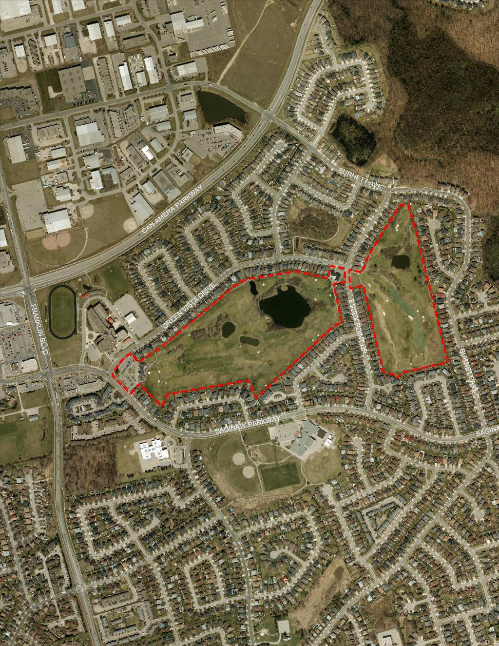
7 AERIAL
8

9 The area within the immediate vicinity subject lands is characterized by a broad range of commercial, institutional and low and medium density residential development. Generally, existing land uses within the vicinity of the subject lands include: NORTH: Situated to the north of the former clubhouse is the St. Benedict Catholic Secondary School which includes the school, parking lot and playing fields. East of the high school are low rise residential uses, including single detached and semi -detached dwellings. A storm water management facility for the community is located on the north side of Green Vista Drive, between Country Club Drive and Essex Point Drive. EAST: Existing low-rise residential uses, including single-detached, semidetached and townhouse dwellings, are situated to the east of the subject lands. Beyond the residential uses along Burnett Avenue is the Portuguese Provincially Significant Swamp Wetland Complex which includes walking trails. WEST: To the west of the subject lands, on the south side of Saginaw Parkway is a mix of commercial and residential uses, including a commercial plaza; a mediumdensity townhouse development; and the St. Margaret Catholic Elementary School. A larger commercial development is located at the northwest corner of Franklin Boulevard and Elgin Street North/Saginaw Parkway. It is anchored by a Metro food store and a Shoppers Drug Mart and features a range of restaurants and convenience commercial and service commercial uses. SOUTH: Existing and planned low-rise residential uses, including single-detached, semidetached and townhouse dwellings, are situated immediately to the south the subject lands. On the south side of the Saginaw Parkway are institutional uses and open space uses, including the Clemens Mill Public Elementary School and the Lions Can-Amera Park.


10 SURROUNDING LAND USES NORTH of the subject lands: Page 5 St. Benedict Catholic Secondary School and low rise residential along Green Vista Drive SOUTH of the subject lands: Clemens Mill Public Elementary School and low rise residential along Longhurst Crescent. Townhouse developments on Stonecairn Drive and Fairgreen Close south of the larger and smaller parcel respectively. Saginaw Subdivision DESIGN BRIEF October 2015 Our File 1422A


11 EAST of the subject lands: Page 6 Semi-detached development on Essex Point Drive east of larger parcel and low Rise Residential Development on Burnett Ave east of smaller parcel. WEST of the subject lands: St. Margaret Catholic Elementary School and one of two townhouse developments on the south side of Saginaw Parkway. Commercial plazas west of the subject lands at the intersection of Franklin Ave. and Saginaw Parkway. Proposed Saginaw Subdivision DESIGN BRIEF September 2015 Our File 1422A
12

13 2.0 MUNICIPAL DESIGN DIRECTION
14 Page MUNICIPAL DESIGN DIRECTION City of Cambridge Official Plan Council of the City of Cambridge adopted a new Official Plan on May 7, 2012 (the Official Plan ). This plan was approved with modifications by the Region on November 21, The City of Cambridge Official Plan was approved as implementation of the adopted Regional Official Plan (ROP) and in conformity with the Places to Grow Growth Plan. The City of Cambridge Official Plan has been appealed (in part) given that the Regional Official Plan (ROP) has been appealed to the OMB in its entirety. Chapter 5 of the Official Plan details urban design policies which generally encourage a high standard of urban design. The urban design policies apply to all development within the City. This Urban Design Brief includes an assessment of the proposal in the context of the policies of the City of Cambridge s Official Plan. Section 5.1 of the Official Plan lists a number of Urban Design objectives, many of which are relevant to the proposed development including: The creation of attractive, accessible, safe and healthy building environments: The protection and enhancement of public views and vistas of natural and built features; Compatibility in scale, form, massing and height transition between new development and existing buildings and adjacent neighbourhoods; and Designing communities at the pedestrian scale in support of walkable neighbourhoods. Chapter 5 provides further design policy direction in sub-sections related to: healthy and liveable communities; transit oriented development; views and vistas; the public realm; gateways; site development and buildings; sustainable design; accessibility/universal design; safety; parking; signage; and public art. Relevant guidelines from these sections have been considered in the preparation of the development concept and this Brief. Section 5.15 outlines the requirements for urban design studies prepared in support of development applications. The requirements, and how these requirements have been addressed are summarized as follows: a) How the proposal meets the objectives and policies of this Plan: A detailed Planning Justification Report has been prepared in support of the development. The Justification Report describes, in detail, how the proposal meets the objectives and key policies of the plan. Key design objectives in the Official Plan are summarized on the opposite page and form the basis for the guidelines contained within. Saginaw Subdivision DESIGN BRIEF October 2015 Our File 1422A
15 Page 8 b) How the proposal fits within any Council approved design guidelines that apply to the site and/or its area: There are no specific design guideline documents that apply to the subject area. c) Proposed and alternative building types, massing, and building materials with a minimum of three concepts to be submitted unless otherwise specified: It is our understanding that this requirement applies to site specific projects as opposed to a subdivision. Any proposed multiple development blocks will be subject to site plan approval. General guidelines for building design are included herein. d) Integration of the proposal into the surrounding streetscape and its relation to surrounding buildings demonstrated through two dimensional and three dimensional visual representation: Again this requirement is directed towards more specific site design. The type of development proposed (low-rise residential) is consistent with the surrounding built form. Compatibility guidelines are included in Section 4.0 of this document. e) Access to sunlight as well as the provision of shade in public and private areas for its health and environmental benefits: Proposed buildings will be low rise in height and are not anticipated to create extensive shadows impacts. Proposed pubic areas such as parks and trails will be adequately landscaped to provide both sun and shade opportunities. f) Landscaping plan including the integration of existing trees and vegetation into the site design and integration with natural features and trails: It is anticipated that detailed streetscape plans will be required as a condition of draft approval. Natural features will be retained and integrated within the plan of subdivision. Section 4.0 of this document provides guidelines for landscaping and includes a figure which shows landscape priority areas. g) Utilities servicing plan: A Functional Servicing Report has been prepared in support of the application. This report considers utility servicing. DESIGN OBJECTIVES Compatibility Accessibility Integration and Conservation of Natural Areas Pedestrian Friendly Design; Transit Supportive Design & High Quality Architectural and Landscape Design Proposed Saginaw Subdivision DESIGN BRIEF September 2015 Our File 1422A
16
17 3.0 MASTER CONCEPT PLAN

18

19
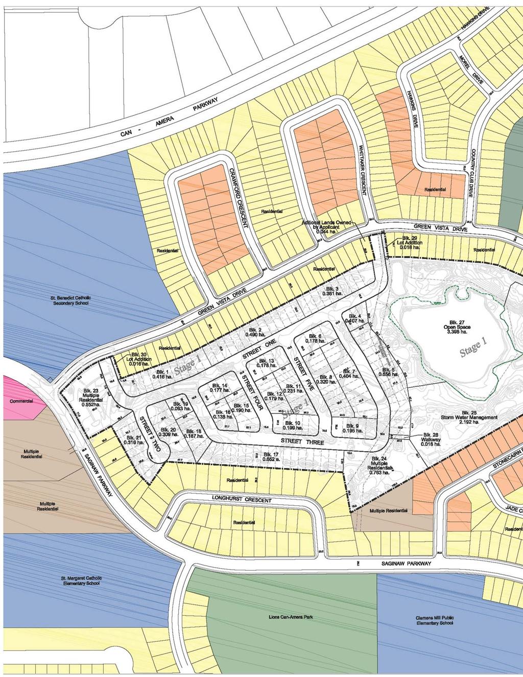
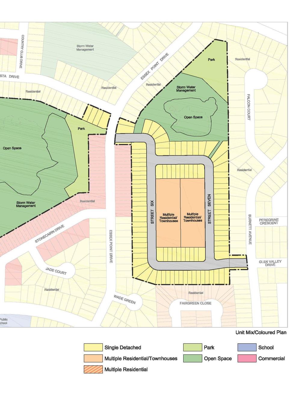
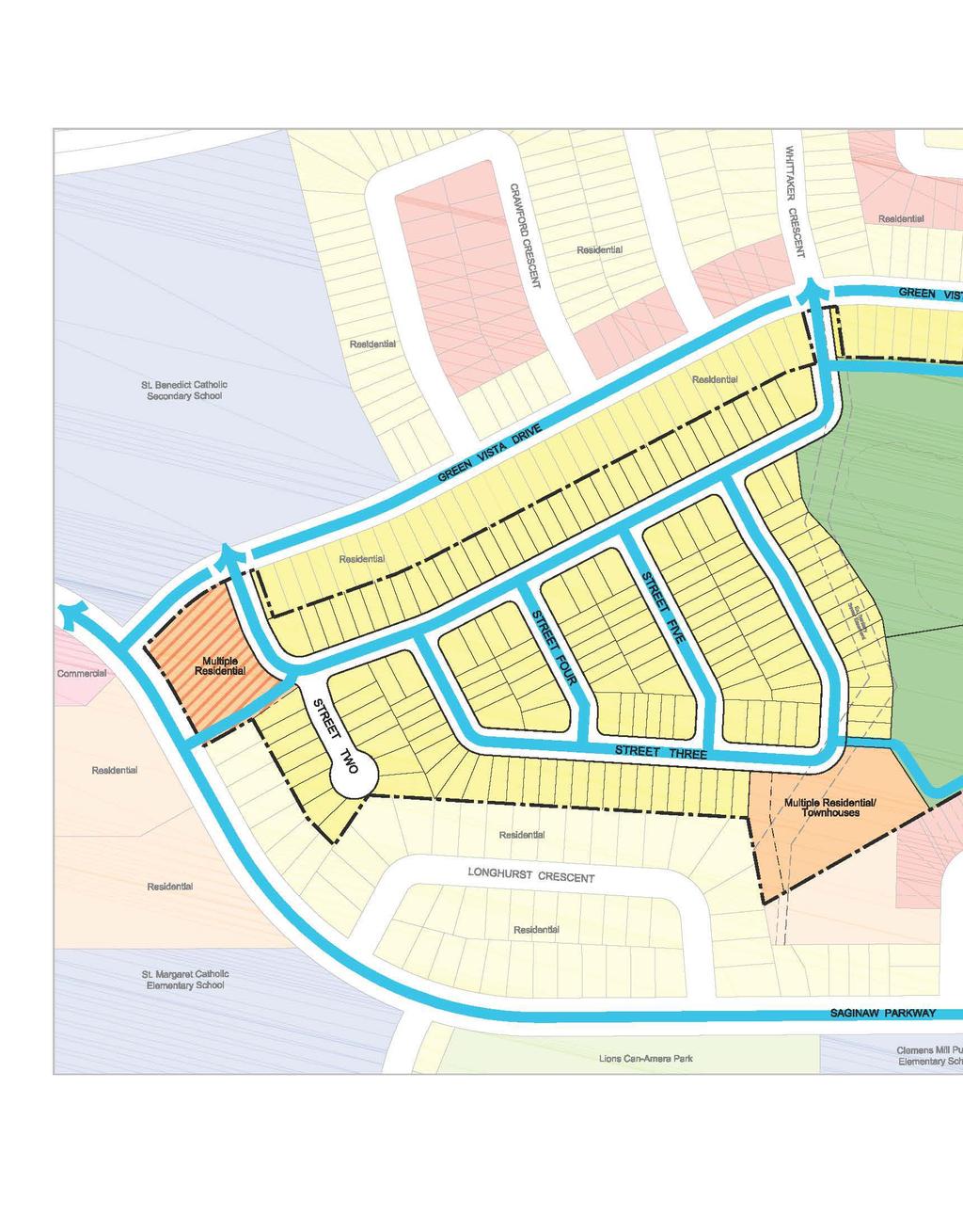
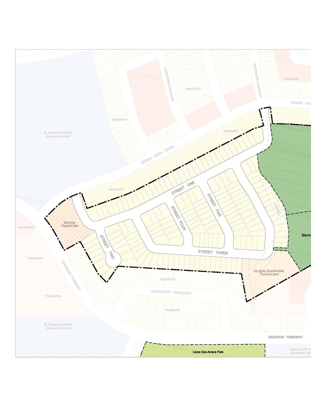
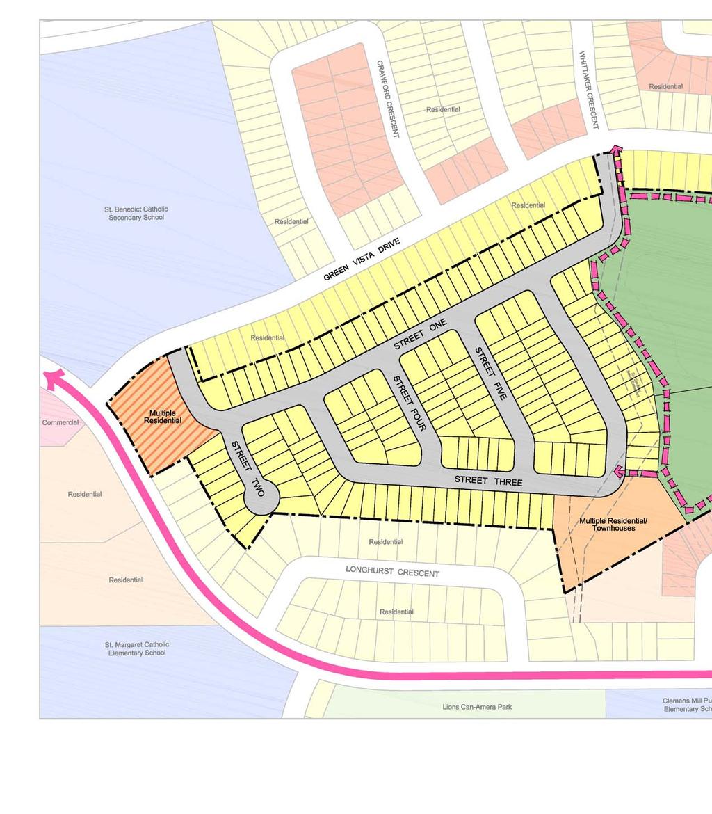
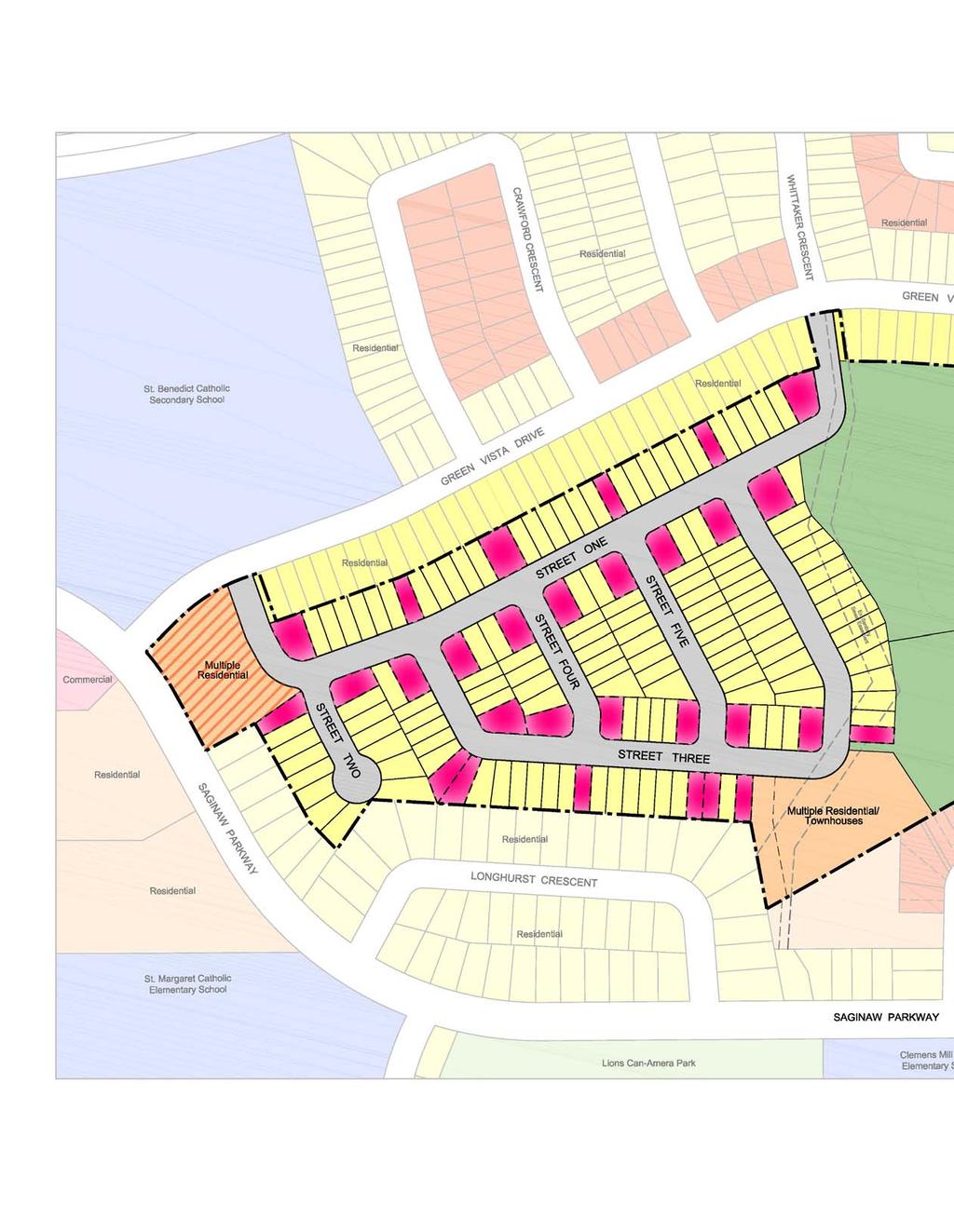
20 3.0 Page 9 MASTER CONCEPT PLAN 31 Blocks planned for low density residential development. 4 Blocks planned for multiple residential development. 459 estimated residential units ha of Park provided which will include a future community trail ha of Open Space conserved ha for Stormwater Management integrated with open space and park blocks. A modified grid street pattern. Multiple street and pedestrian connections to the surrounding community. Shorter block lengths to encourage walking and active transportation. Unit types similar in type to abutting properties. Saginaw Subdivision DESIGN BRIEF October 2015 Our File 1422A


21 Page 10 Shorter block lengths and a modified grid pattern to encourage walking and active transportation. Compatibility with surrounding land uses considered with proposed unit types similar in type to abutting properties ha of Open Space conserved and enhanced with proposed habitat improvements ha of Park space provided including future community trails.
22

23 4.0 DESIGN PRINCIPLES
24 Page DESIGN PRINCIPLES The Master Plan has been designed around key design principles derived from Official Plan policy and design direction: Compatibility To create a neighbourhood that exists in harmony with the surrounding established community. Connectivity / Accessibility To design a road network that is well connected to the surrounding community and accessible and safe for pedestrians and cyclists. Integration and Conservation To conserve, protect and integrate existing natural heritage resources. Walkability and Pedestrian Friendly Design To create walkable neighbourhoods that are well connected and fully accessible to major destinations and surrounding neighbourhoods. Transit Supportive To design and build neighbourhoods that provide accessibility to and support for transit and other active modes of transportation. High Quality Architecture and Landscape Design To build neighbourhoods that provide a range of well designed, high quality housing, parks and open spaces. The following sections illustrate how these principles have been considered in the ultimate design of the proposed neighbourhood. Saginaw Subdivision DESIGN BRIEF October 2015 Our File 1422A


25 Compatibility Accessibility Integration and Conservation of Natural Areas Pedestrian Friendly Design; Transit Supportive Design & High Quality Architectural and Landscape Design Page 12
26 Page 13 COMPATIBILITY To create a neighbourhood that exists in harmony with the surrounding established community. The following is a summary of how the design of the subdivision achieves the principle of compatibility: The height, massing and scale of new buildings is distributed on the site in such a manner as to provide an appropriate transition between new development and existing houses in the neighbourhood. (Official Plan Policy Reference: a, a,b and g) A Shadow Study has been completed for the proposed seniors residence. This study (included herein) demonstrates that shadow impacts are minimal. Where possible new lots will achieve similar lot coverage and side yard setbacks to neighbouring housing. (Official Plan Policy Reference: c) Larger lots will be located adjacent to existing large lots with transitions in lot width occurring at the rear lot line. Larger lot widths are concentrated along the exterior of the subdivision in order to reinforce the physical character of the neighbourhood and minimize the impact of the proposed redevelopment of existing homes. Densities will be regulated through the implementing zoning by-law and will be consistent with the range of densities permitted on adjacent lands. In most instances, housing type matches similar housing type at the rear lot interface. New townhomes are located either internal to the subdivision or abutting existing townhomes. This helps to achieve appropriate transitions between different land uses. (Official Plan Policy Reference: c) Proposed Multi-Unit Residential development blocks are a suitable size and configuration to provide for adequate parking, access and circulation by emergency vehicles, and to allow for appropriate separation of appropriate integration of on-site vehicular and pedestrian traffic. (Official Plan Policy Reference: 8.4.3c) Proposed Multi-Unit Residential development will be developed at in a manner which will ensure the proposed development is compatible with existing development in terms of building height, setbacks, landscaping and vehicular circulation. (Official Plan Policy Reference: 8.4.3d) The design of the landscaping for the subject lands will assist in the visual integration of the proposed development into the neighbourhood. (Official Plan Policy Reference: e) This may include the use of similar tree species along the streetscapes. The figures on the following pages illustrate: the Shadow Study completed for the proposed seniors residence, and the proposed land use / unit mix for the subject lands in relation to immediately abutting properties. Saginaw Subdivision DESIGN BRIEF October 2015 Our File 1422A

27 Page 14 Proposed Saginaw Subdivision DESIGN BRIEF September 2015 Our File 1422A

28 # of Single Detached Lots: 264 % of total units: 57.5% # of Townhouse Units: 95 % of total units: 20.7% # of Multiple Residential Units: 100 % of total units: 21.8% Total Units: %
29
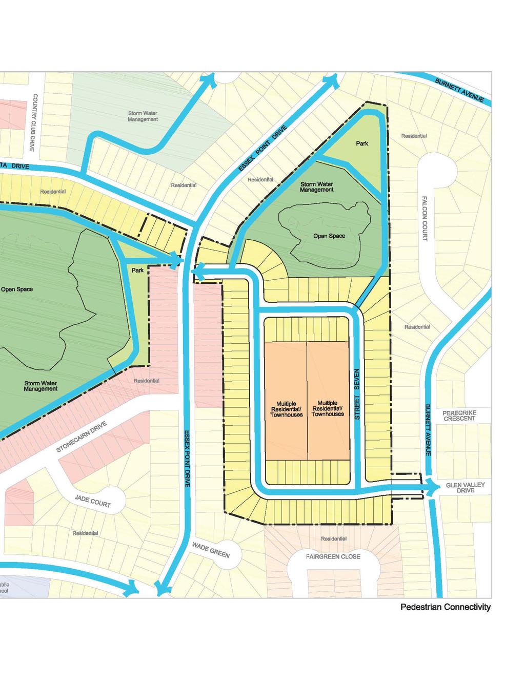
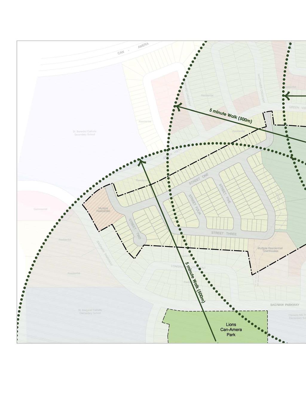
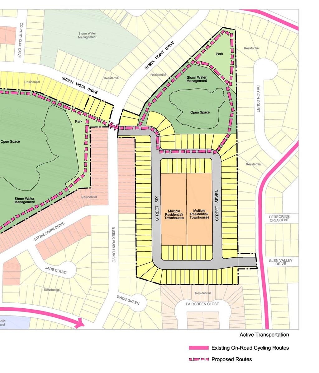
30 Page 15 CONNECTIVITY AND ACCESSIBILITY To design a road network that is well connected to the surrounding community and accessible and safe for pedestrians and cyclists. The following is a summary of how the subdivision has been designed to be well connected and accessible to and from the surrounding community: Sidewalks will be provided along each of the proposed streets allowing for efficient pedestrian circulation within the subdivision and external linkages to transit stops and nearby non-residential land uses. The provision of sidewalks will assist in the provision of a safe environment for pedestrians and encourages pedestrian activity (Official Plan Policy Reference 5.3.1b) The proposed street pattern has been designed to allow for efficient vehicular movement within the subdivision. Multiple connections to the broader road network are provided in order to allow for convenient access to collector and arterial roads. This allows for ease of travel within this part of the City by multiple modes of transportation. (Official Plan Policy Reference 5.1b) Subdivision streets have been designed to accommodate two-way traffic, on-street parking and sidewalks. Streets have been designed at a sufficient width for circulation by emergency vehicles. Multiple Residential blocks have been sized to ensure adequate access and circulation by emergency vehicles (Official Plan Policy Reference c). The subdivision is in proximity to existing and planned parks. The proposed subdivision development supports existing and future transit in the area. All lots/ blocks are well within 500 m (five minute walk) of existing transit stops. The proposed subdivision is located in proximity to the City s Bikeway Network including cycling routes along Can-Amera Parkway, Saginaw Parkway, Cowan Boulevard and Burnett Avenue. A Multi- Use Trail is planned along Franklin Boulevard. The open space and park network will link with sidewalks through the community and proposed publically accessible trails within the development. The diagram on the following page illustrates pedestrian connectivity via sidewalks, trails and walkways. Saginaw Subdivision DESIGN BRIEF October 2015 Our File 1422A


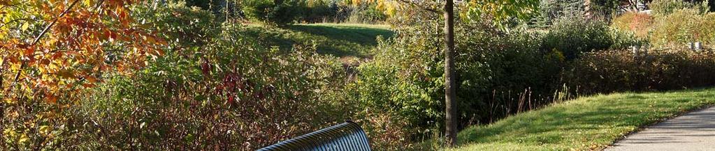
31 Page 16 Existing cycling route along Burnett Avenue. The existing storm sewer and emergency overflow access will be utilized as a future road connection into the site.
32
33
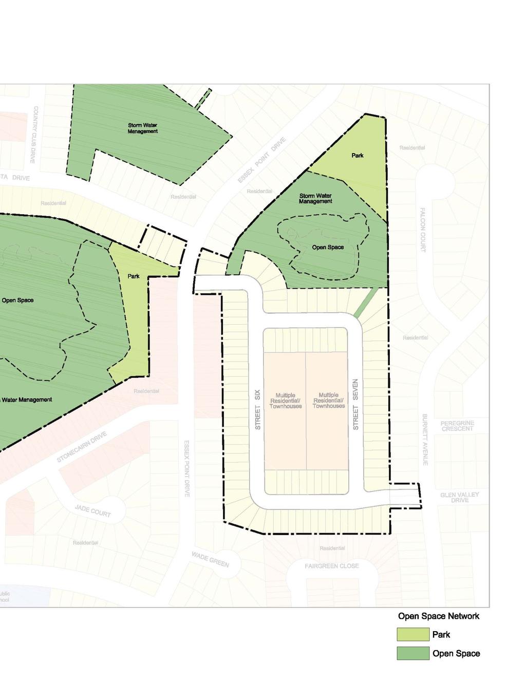
34 Page 17 INTEGRATION AND CONSERVATION To conserve, protect and integrate existing natural heritage resources. The following is a summary of how the subdivision has been designed to conserve, enhance and integrate key natural features: The proposed development establishes a public open space system which assists in the creation of healthy active communities. (Official Plan Policy Reference 7.1.2) An Environmental Impact Study (EIS) was prepared and includes the surveyed limit of natural heritage features. The EIS report recommends a number of opportunities and locations for wildlife habitat creation including: the installation of floating wetlands; installation of logs in the wetland for turtle basking; installation of standing snags around the perimeter of the wetland to provide perches and nesting habitat; installation of bird boxes for swallows and other species; installation of sand and gravel mounds for turtle nesting; and installation of snake hibernacula. The existing Provincially Significant Wetland and unevaluated wetland located on the subject lands are proposed to be maintained and enhanced. The Provincially Significant Wetland is identified as a Core Environmental Feature, and the unevaluated wetland as a Locally Significant Natural Area (LSNA). Buffers from the Core Environmental and LSNA features are provided. Blocks planned for Stormwater Management will be dedicated to the City. The uses of fences within these stormwater management areas will be avoided to minimize the risk to the public. Opportunities for naturalization within stormwater management blocks will be explored, which further enhances the open space system. Planned parks and trails contribute to the overall open space system. Planned neighbourhood parks will be open space areas that provide passive or active recreational opportunities centrally located within the larger community. (Official Plan Policy Reference ) The design of the proposed development will promote sustainable, healthy, active living through the protection of resilient natural areas that are better connected to residential areas. (Official Plan Policy Reference c). The diagram on the following page illustrates the proposed open space network. Saginaw Subdivision DESIGN BRIEF October 2015 Our File 1422A


35 Page 18 Existing wetlands will be conserved and enhanced. Parks should be designed with strategically placed viewpoints to the abutting natural features.
36
37
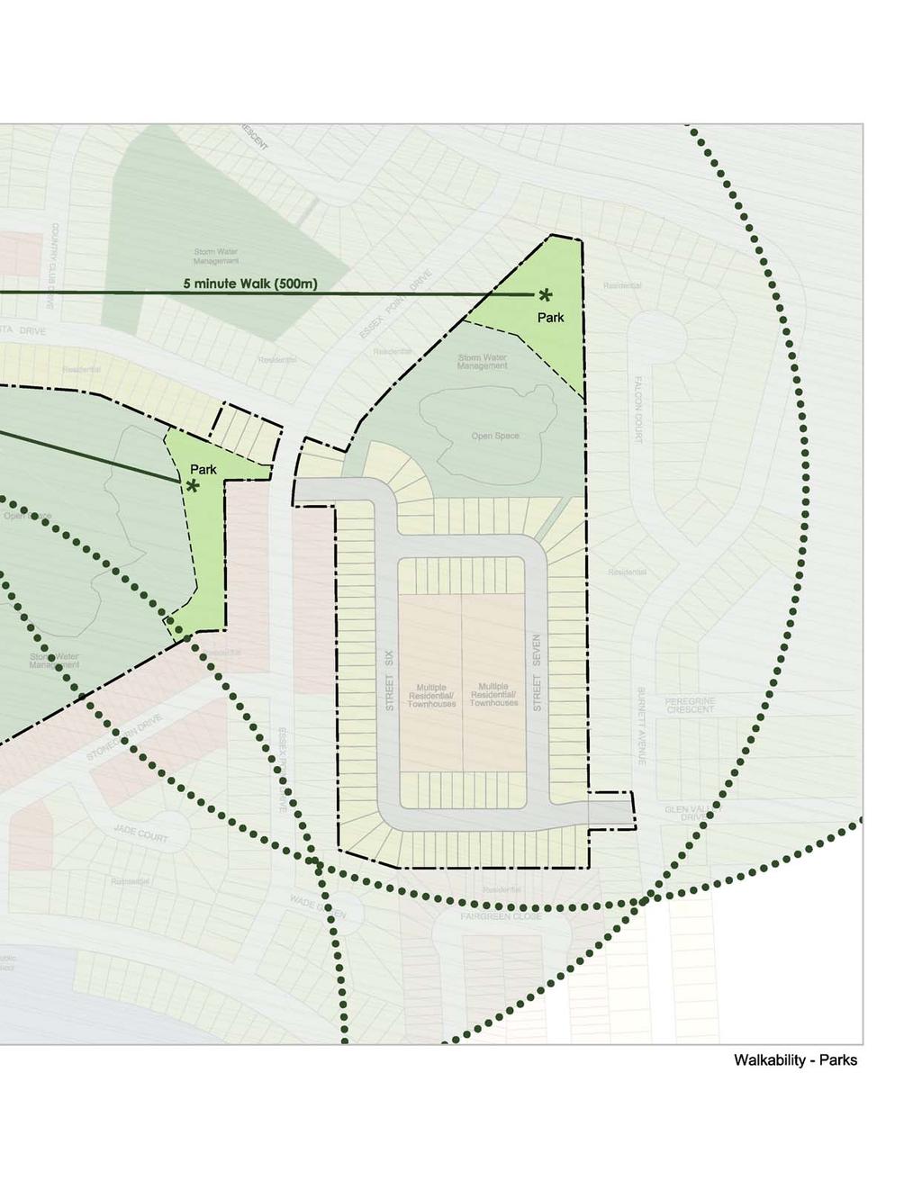
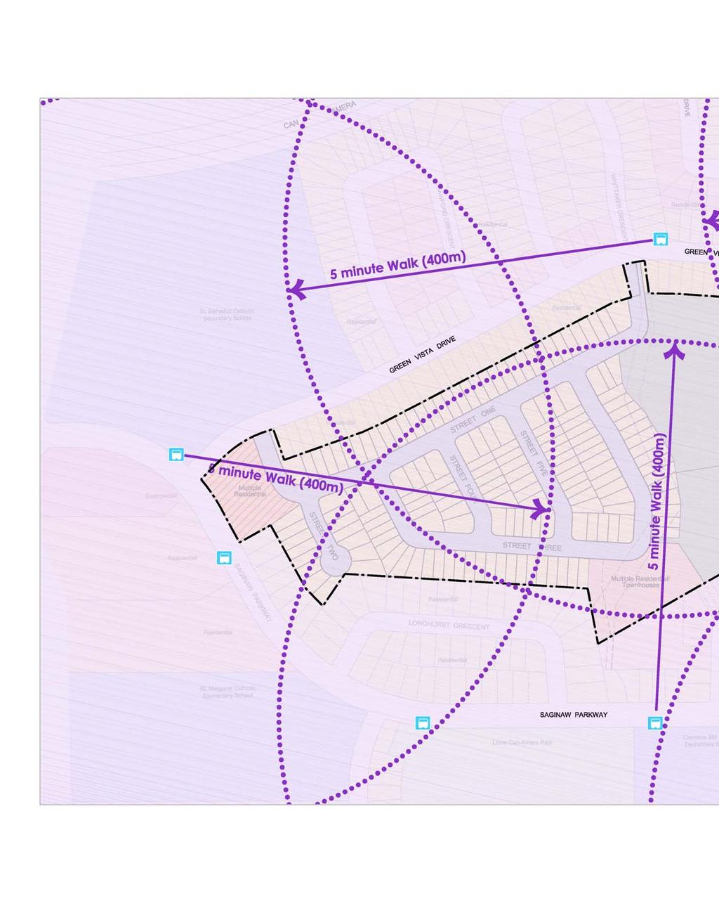
38 Page 19 WALKABILITY AND PEDESTRIAN FRIENDLY DESIGN To create walkable neighbourhoods that are well connected and fully accessible to major destinations and surrounding neighbourhoods. The following is a summary of how the subdivision has been designed to be pedestrian friendly and highly walkable: The subdivision has been designed at the pedestrian scale to foster social interaction, active streetscapes and walkability. (Official Plan Policy Reference 5.1.k) The design of the proposed development promotes sustainable, healthy, active living through well connected and maintained streets, paths and trails that are able to safely accommodate different modes of transportation. (Official Plan Policy Reference a). A walkable neighbourhood is achieved by providing a mix of uses and range of housing types with convenient access to public transportation (Official Plan Policy reference d). Open spaces, parks, trails and sidewalks will be interconnected resulting in a very walkable community. The proposed neighbourhood parks are connected to open space blocks and will be connected to the rest of the neighbourhood via trails. A modified grid pattern with many short blocks increase overall walkability. Parks and open space are distributed throughout and connected to the overall community. All future residents will be within a 5 minute walk of existing and proposed parks. Trails through the proposed stormwater management blocks will further enhance connectivity and walkability. The proposed developments helps to achieve growth management objectives of the Official Plan by providing a new neighbourhood that is safe, attractive, pedestrian friendly, integrated with the natural heritage system and readily linked by nearby transit routes to other areas of the City. (Official Plan Policy Reference 2.2.j) The diagram on the following page illustrates five minute walking distances from the existing park south of Saginaw and the two proposed parks on the subject lands. The diagram illustrates that the entire development, as well as several homes outside of the development, will be within a five minute walking distance of parkland. Saginaw Subdivision DESIGN BRIEF October 2015 Our File 1422A


39 Page 20
40
41
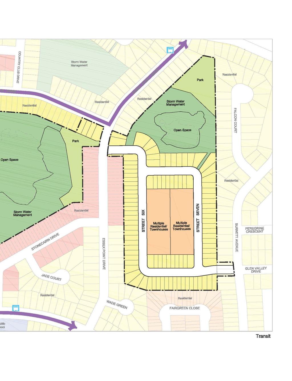
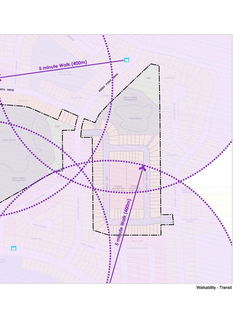
42 Page 21 TRANSIT SUPPORTIVE To design and build neighbourhoods that provide accessibility to and support for transit and other active modes of transportation. The following is a summary of how proposed subdivision will support transit and active transportation: The proposed subdivision in its entirety is located within a five minute walk to existing public transit. There are a variety of public bus routes, operated by Grand River Transit in proximity to the development. The subject lands are located within convenient access to the Region s developing Rapid Transit Network with access to future stops available through the existing transit network. A modified grid pattern has been used to increase connectivity and provide short walking distances to existing transit routes and stops. The City encourages transit oriented development along existing and planned high frequency transit routes. (Official Plan Policy Reference ) A proposed multiple residential block has been located adjacent to the existing transit routes on Saginaw Parkway and Green Vista Drive. This block allows for denser development in proximity to existing transit, at a scale and height that is appropriate given the surrounding neighbourhood. The subject lands are located with access to the City s Bikeway Network including cycling networks along Can-Amera Parkway, Saginaw Parkway, Cowan Boulevard and Burnett Avenue. Measures to increase active transportation through the provision of bicycle racks (within multiple development blocks), pedestrian walkways, sidewalks and proximity to transit stops. (Official Plan Policy Reference ) The proposed development helps to achieve the City s Growth Management objectives by providing a compact urban development that promotes a mix of uses and transit oriented development. (Official Plan Policy Reference 2.2.f) Within the development a high quality public realm is proposed which will enhance the identity of the area and create gathering points fostering a positive pedestrian experience. (Official Plan Policy Reference c) The diagrams on the following page illustrates the active transportation network, the existing transit network and five minute (500 m) walking distances from existing transit stops. Saginaw Subdivision DESIGN BRIEF October 2015 Our File 1422A


43 Page 22 Existing transit route along Saginaw Parkway The Saginaw transit route will connect with the Region s rapid transit network.
44
45
46
47
48
49
50 Page 23 HIGH QUALITY ARCHITECTURE AND LANDSCAPE DESIGN To build neighbourhoods that provide a range of housing types, parks and open spaces. Implementation of the following design considerations will help to achieve a subdivision with high quality architectural and landscape design: The subject lands and broader community have been designed with a variety of uses including residential, open space, stormwater management, parks, commercial, employment and institutional (school). A variety of housing types and built form are proposed together with a significant open space network both of which contribute to the overall mix of uses within this community. A mix of single detached, street fronting multiple residential and multiple residential units are proposed. Prominent lots with high visibility such as lots that terminate a view are encouraged to meet a higher standard of architectural quality and urban design. (Official Plan Policy Reference 5.4.2) As such, special built form design consideration is encouraged for identified priority lots, including corner lots, gateway lots, terminating vista lots, and lots along bends in the road network. Corner lots are encouraged to be designed in a manner which addresses both the front and flanking streets. Where possible, corner lots will orient the garage to the side streets to minimize vehicular conflicts. Existing natural features including the two wetlands are proposed to be maintained and enhanced and integrated within the larger open space network. The open space network, including stormwanter management blocks will be enhanced through the use of landscaping where possible. Parks will be designed to include lookout opportunities. (Official Plan Policy Reference 5.4.2) Future landscaping will assist in the visual integration of the proposed development within the broader neighbourhood. Street trees and landscaping will provide a visually attractive streetscape. Where possible mature trees will be retained. The proposed multi-unit blocks have been designed at an appropriate size to accommodate amenities, buffering and landscaping. (Official Plan Policy Reference 8.4.3) A six-storey seniors residence is proposed within the multiple residential block at the intersection of Saginaw Parkway and Green Vista Drive. Building placement within this block should be oriented to the street in a manner which results in minimal if any shadow impacts on abutting properties. High quality landscaping, in particular along the interface with single-detached dwellings is strongly encouraged. Saginaw Subdivision DESIGN BRIEF October 2015 Our File 1422A
51 Page 24 The subject lands have an elevation lower than the surrounding residential uses which will minimize the potential for shadow or privacy impacts. Variations in building façades and materials are encouraged. Visual cues can be taken from the surrounding development in terms of roof pitches, building heights and architectural details (gables, dormers, porches,etc), however the proposed development should read as new, contemporary and distinct from the existing built form in the area. Architectural treatment of garage doors is encouraged and minimized garage projections are encouraged. The diagram on the following page illustrates priority lots.
52

53
54

55 5.0 DESIGN SUMMARY
56 Page 25 DESIGN SUMMARY The subdivision and broader community have been designed with a variety of uses including residential, open space, stormwater management, parks, commercial, employment and institutional uses. The proposed development represents appropriate infill and will be compatible with existing development. The height, massing and scale of the proposed development has been distributed on the site in such a manner as to provide an appropriate transition between new development and existing houses in the neighbourhood. Subdivision streets have been designed to accommodate two-way traffic, on-street parking and sidewalks. Streets have been designed at a sufficient width for circulation by emergency vehicles. Multiple Residential blocks have been sized to ensure adequate access and circulation by emergency vehicles The development supports existing transit and has been designed to facilitate other modes of active transportation. All future residents will be within a 5 minute walk of existing transit stops. Two internal parks are proposed and will be integrated within a larger open space network. All future residents will be within a 5 minute walk of proposed parks. The modified grid pattern proposed throughout the development together with sidewalks, pedestrian linkages and trails will increase connectivity providing for shorter walking distances to community facilities. Natural heritage resources are conserved, protected and integrated within the overall plan. Enhanced architectural design is proposed for priority lots, including corner lots, gateway lots, and terminating vista lots. Enhanced landscaping is proposed within identified landscape priority areas. In conclusion, the proposed subdivision will be well designed as a safe, attractive, pedestrian friendly community integrated with the natural heritage system and readily linked by nearby transit to other areas of the City.

57 Compatibility Accessibility Integration and Conservation of Natural Areas Pedestrian Friendly Design; Transit Supportive Design & High Quality Architectural and Landscape Page 25 Design Proposed Saginaw Subdivision DESIGN BRIEF September 2015 Our File 1422A

58
URBAN DESIGN BRIEF URBAN DESIGN BRIEF 721 FRANKLIN BLVD, CAMBRIDGE August 2018
 URBAN DESIGN BRIEF URBAN DESIGN BRIEF 721 FRANKLIN BLVD, CAMBRIDGE August 2018 DESIGN BRIEF CONTENTS PART A 1.0 INTRODUCTION 2.0 DESCRIPTION & ANALYSIS OF SITE CONTEXT 3.0 DESIGN CONSTRAINTS AND OPPORTUNITIES
URBAN DESIGN BRIEF. 2136&2148 Trafalgar Road. Town of Oakville
 URBAN DESIGN BRIEF 2136&2148 Trafalgar Road Town of Oakville Prepared By: METROPOLITAN CONSULTING INC For 2500674 Ontario Inc November 2016 TABLE OF CONTENTS Page No. 1.0 Introduction/Description of Subject
URBAN DESIGN BRIEF 181 Burloak Drive, Oakville
 URBAN DESIGN BRIEF 181 Burloak Drive, Oakville February 2017 Our File: 1730B 230-7050 WESTON ROAD / WOODBRIDGE / ONTARIO / L4L 8G7 / T: 905 761 5588/ F: 905 761 5589/WWW.MHBCPLAN.COM TABLE OF CONTENTS
ELMVALE ACRES SHOPPING CENTRE MASTER PLAN
 ELMVALE ACRES SHOPPING CENTRE MASTER PLAN Contents 1.0 INTRODUCTION... 2 2.0 LOCATION... 2 3.0 EXISTING CONTEXT... 2 4.0 VISION & GUIDING PRINCIPLES... 2 5.0 LAND USE AND BUILT FORM... 4 5.1 St. Laurent
Westwind Developments Ltd. PIONEER LANDS AREA STRUCTURE PLAN - PROPOSED AMENDMENT
 FEBRUARY 2013 TABLE OF CONTENTS 1.0 BACKGROUND... 1 1.1 Amendment... 1 2.0 LOCATION & CONTEXT... 2 2.1 Land Ownership... 2 3.0 POLICY CONTEXT... 3 3.1 Municipal Development Plan... 3 3.2 Capital Region
DRAFT Northeast Quadrant of Kipling Avenue and Highway 7 DRAFT AUGUST 29, Goals Land Use. The goals of this Plan are to:
 AUGUST 29, 2017 12.15 Northeast Quadrant of Kipling Avenue and Highway 7 12.15.1 Goals 12.15.2 Land Use The goals of this Plan are to: 12.15.2.1 General Provisions: a) Ensure the development of a compact
CONTENTS 8.0 LAND USE 8.1 GENERAL LAND USE 8.2 RESIDENTIAL 8.3 MIXED USE 8.4 COMMERCIAL 8.5 EMPLOYMENT LANDS
 8-2 Land Use 8.0 LAND USE CONTENTS 8.1 GENERAL LAND USE 8.1.1 Uses provided for in all Land Use Designations 8.1.2 Uses prohibited in Hazardous Lands, Hazardous Sites and Special Policy Areas 8.1.3 Uses
Urban Design Brief. Watson Parkway North & Watson Road North Guelph, Ontario. Prepared by Coletara Development
 Urban Design Brief Watson Parkway North & Watson Road North Guelph, Ontario Prepared by Coletara Development December, 2013 Urban Design Brief, Coletara Development 1 Introduction This Urban Design Brief
New-Cast Mixed-use Development Proposal King Street West, Newcastle, Ontario
 URBAN DESIGN BRIEF New-Cast Mixed-use Development Proposal King Street West, Newcastle, Ontario TABLE OF CONTENTS: 1.0 Executive Summary 2.0 Creating Vibrant and Sustainable Urban Places: Excerpts from
PORT WHITBY COMMUNITY
 PORT WHITBY COMMUNITY SECONDARY PLAN UPDATE COMMUNITY IMPROVEMENT PLAN URBAN DESIGN GUIDELINES September 2015 DRAFT PROPOSED AMENDMENT NUMBER # to the Whitby Official Plan PURPOSE: The intent of this Amendment
*** DRAFT 2 FOR PUBLIC REVIEW ***
 6.7 The area is generally bounded by the Red Hill Valley Parkway to the west, Lake Avenue to the east, the Queen Elizabeth Way (QEW) to the north, and by the properties just south of Queenston Road to
Complete Neighbourhood Guidelines Review Tool
 Complete Neighbourhood Guidelines Review Tool Prepared By: City of Regina Planning Department October 2014 Page 1 of 14 Community Development Review Checklist for Secondary Plans and Concept Plans The
URBAN DESIGN BRIEF 305, 309, & 315 SOUTHDALE ROAD WEST LONDON ONTARIO
 URBAN DESIGN BRIEF 305, 309, & 315 SOUTHDALE ROAD WEST LONDON ONTARIO CARVEST PROPERTIES LTD. December 2013 Section 1 - Land Use Planning Context 1.1 Subject Lands The subject lands are located immediately
Urban Design Brief Proposed Residential Development 5219 Upper Middle Road City of Burlington
 Urban Design Brief Proposed Residential Development 5219 Upper Middle Road City of Burlington Prepared by Weston Consulting Prepared for BLOOMFIELD DEVELOPMENT INC. Date: March 2017 Table of Contents 1.
Urban Design Brief December 23, 2015 Southside Construction Group Official Plan & Zoning By-Law Amendment
 Urban Design Brief Proposed Official Plan & Zoning By-Law Amendment 3244, 3263 and 3274 Wonderland Road South Southside Group December 23, 2015 TABLE OF CONTENTS Page No. INTRODUCTION... 1 SECTION 1 LAND
Bressa Developments Limited. Planning Justification Report. Revised Draft Plan of Subdivision and Zoning By-Law Amendment
 Bressa Developments Limited Revised Draft Plan of Subdivision and Zoning By-Law Amendment Planning Justification Report Part of Lots 7 & 8 Concession 1, North of Dundas Street Town of Oakville September,
The West Vaughan Employment Area Secondary Plan Policies
 Part 2: The West Vaughan Employment Area Secondary Plan Policies 2.1 General Policies It is the policy of Council: 2.1.1. That the West Vaughan Employment Area (the WVEA), identified on Schedule 1, will
2136 & 2148 Trafalgar Road Town of Oakville Region of Halton
 PLANNING JUSTIFICATION REPORT 2136 & 2148 Trafalgar Road Town of Oakville Region of Halton Zoning By-Law Amendment Application 2500674 Ontario Inc. November 2016 Table of Contents Page 1.0 Location/Summary
Gold Line Bus Rapid Transit Transit Oriented Development (BRTOD) Helmo Station Area Plan
 Helmo Station Area Plan") Appendix F Gold Line Bus Rapid Transit Transit Oriented Development (BRTOD) Helmo Station Area Plan Introduction and Purpose of the Plan The Gold Line Bus Rapid Transit facility is an eleven-mile dedicated
Appendix F Gold Line Bus Rapid Transit Transit Oriented Development (BRTOD) Helmo Station Area Plan Introduction and Purpose of the Plan The Gold Line Bus Rapid Transit facility is an eleven-mile dedicated
Appendix C: Interim Mixed-Use Evaluation Criteria
 Appendix C: Interim Mixed-Use Evaluation Criteria C-1 Appendix C: Interim Mixed-Use Evaluation Criteria PURPOSE: The implementation of numerous policies contained within the Master Plan hinges on the creation
Edward R. Sajecki Commissioner of Planning and Building. Land Use Review- Former Parkway Belt West Lands- Fieldgate Drive and Audubon Boulevard
 Corporate Report Clerk s Files Originator s Files CD.04.FOR DATE: November 15, 2011 TO: FROM: SUBJECT: Chair and Members of Planning and Development Committee Meeting Date: December 5, 2011 Edward R. Sajecki
[PLANNING RATIONALE] For Site Plan Control and Lifting of Holding Zone By-Law 101 Champagne Avenue. May 23, 2014
![[PLANNING RATIONALE] For Site Plan Control and Lifting of Holding Zone By-Law 101 Champagne Avenue. May 23, 2014](/thumbs/75/71599615.jpg "[PLANNING RATIONALE] For Site Plan Control and Lifting of Holding Zone By-Law 101 Champagne Avenue. May 23, 2014") [PLANNING RATIONALE] For Site Plan Control and Lifting of Holding Zone By-Law 101 Champagne Avenue May 23, 2014 Contents 1.0 Introduction... 2 2.0 Site Context... 2 2.1 Adjacent Uses... 2 Figure 1: Site
[PLANNING RATIONALE] For Site Plan Control and Lifting of Holding Zone By-Law 101 Champagne Avenue May 23, 2014 Contents 1.0 Introduction... 2 2.0 Site Context... 2 2.1 Adjacent Uses... 2 Figure 1: Site
QUEEN-RIVER SECONDARY PLAN
 34 QUEEN-RIVER SECONDARY PLAN 34. QUEEN RIVER SECONDARY PLAN 1. INTRODUCTION The Queen-River area is approximately 6.4 hectares and is located at the eastern edge of the Downtown as shown on Map 34-1.
178 Carruthers Properties Inc.
 178 Carruthers Properties Inc. Planning Rationale for 178 Carruthers Avenue Site Plan Control Application June 2014 Table of Contents 1.0 Introduction 2.0 Overview of Subject Property 3.0 Current Zoning
URBAN DESIGN BRIEF Gordon Street City of Guelph. Prepared on behalf of Ontario Inc. March 25, Project No. 1507
 URBAN DESIGN BRIEF 1131 Gordon Street City of Guelph Prepared on behalf of 1876698 Ontario Inc. March 25, 2016 Project No. 1507 423 Woolwich Street, Suite 201, Guelph, Ontario, N1H 3X3 Phone (519) 836-7526
Urban Design Brief. 583, 585 and 589 OXFORD STREET EAST. Salt Clinic Canada Inc.
 Urban Design Brief 583, 585 and 589 OXFORD STREET EAST Salt Clinic Canada Inc. February 3, 2013 TABLE OF CONTENTS Page No. INTRODUCTION... 1 SECTION 1 LAND USE PLANNING CONCEPT... 1 1.1 The Subject Property...
Urban Design Manual PLANNING AROUND RAPID TRANSIT STATIONS (PARTS) Introduction. Station Study Areas
 Introduction. Station Study Areas") 111111 PLANNING AROUND RAPID TRANSIT STATIONS (PARTS) Introduction The ION rapid transit system will link Waterloo, Kitchener and Cambridge through a central transit corridor (CTC). There are a number
111111 PLANNING AROUND RAPID TRANSIT STATIONS (PARTS) Introduction The ION rapid transit system will link Waterloo, Kitchener and Cambridge through a central transit corridor (CTC). There are a number
Queensborough Eastern Neighbourhood Node. Community Open House
 Queensborough Eastern Community Open House The Vision The Queensborough Eastern will become the heart of eastern Queensborough. Through a sensitive mix of viable commercial and residential areas, the neighbourhood
FORMER CANADIAN FORCES BASE (CFB) ROCKCLIFFE SECONDARY PLAN. Official Plan Amendment XX to the Official Plan for the City of Ottawa
 ROCKCLIFFE SECONDARY PLAN. Official Plan Amendment XX to the Official Plan for the City of Ottawa") FORMER CANADIAN FORCES BASE (CFB) ROCKCLIFFE SECONDARY PLAN Official Plan Amendment XX to the Official Plan for the City of Ottawa 1 INDEX THE STATEMENT OF COMPONENTS PART A THE PREAMBLE PAGE Purpose...
FORMER CANADIAN FORCES BASE (CFB) ROCKCLIFFE SECONDARY PLAN Official Plan Amendment XX to the Official Plan for the City of Ottawa 1 INDEX THE STATEMENT OF COMPONENTS PART A THE PREAMBLE PAGE Purpose...
East Bayshore Road Neighbourhood
 East Bayshore Road Neighbourhood Northridge Property Management Urban Design Brief 3195 East Bayshore Road City of Owen Sound January 2016 East Bayshore Road Neighbourhood Northridge Property Management
City of Vaughan Urban Design Guidelines for Infill Development in Established Low-Rise Residential Neighbourhoods
 City of Vaughan Urban Design Guidelines for Infill Development in Established Low-Rise Residential Neighbourhoods DRAFT - September 2016 Contents 1. Introduction 1 2. Policy Context 3 3. Characteristics
Further input invited as Colchester Growth Strategy nears final phase
 IUE 3 / NOVEMBER 2015 Further input invited as Colchester Growth trategy nears final phase trathcona County is seeking public feedback as it enters the final phase of work on a Growth Management trategy
Regency Developments. Urban Design Brief. Holyrood DC2 Rezoning
 Regency Developments Urban Design Brief Holyrood DC2 Rezoning Stantec Consulting Ltd. 7-31-2017 1. Overview Regency Developments intends to rezone the lands located at 8510 and 8511 93 Avenue, within the
Commercial Development Proposal Tenth Line Road. Planning Rationale Report. Minto Developments Inc.
 Commercial Development Proposal 2168 Tenth Line Road Report September 2015 Prepared for Minto Developments Inc. Paquette Planning Associates Ltd. 56 Hutchison Avenue Ottawa, Ontario K1Y 4A3 PH: 613-722-7217
TRAFALGAR ROAD
 158-2192 TRAFALGAR ROAD URBAN DESIGN BRIEF PREPARED BY KLM PLANNING PARTNERS INC. FOR DUNPAR DEVELOPMENTS INC. TOWN OF OAKVILLE JUNE 2012 TABLE OF CONTENTS 1 INTRODUCTION 1.1 Project Description...1 1.1.1
PLANNING JUSTIFICATION REPORT
 80 & 85 MUNCH AVENUE CITY OF CAMBRIDGE PREPARED FOR: REID S HERITAGE HOMES ON BEHALF OF NORRICH WEST INC. PREPARED BY: LABRECHE PATTERSON & ASSOCIATES INC. VICTOR LABRECHE, MCIP, RPP PRINCIPAL, SENIOR
Urban Design Brief Fanshawe Park Road. Competition Toyota
 Urban Design Brief 1300 Fanshawe Park Road Competition Toyota May 2, 2014 TABLE OF CONTENTS Page No. INTRODUCTION... 1 SECTION 1 LAND USE PLANNING CONTEXT... 1 1.1 The Subject Lands... 1 1.2 The Proposal...
Design Brief and Planning Rationale. for Site Plan Control Application. Harmony Subdivision, Stage 1, Block 104
 Design Brief and Planning Rationale for Site Plan Control Application Harmony Subdivision, Stage 1, Block 104 4025 Strandherd Drive, Minto Communities Inc. Prepared By: NOVATECH Suite 200, 240 Michael
Leonard s Beach Secondary Plan (Alcona North) Official Plan Amendment
 Official Plan Amendment") Leonard s Beach Secondary Plan (Alcona North) Official Plan Amendment Public Meeting Presentation August 14, 2013 Note: This document is for presentation purposes only. Please see Staff Report DSR-135-13
Leonard s Beach Secondary Plan (Alcona North) Official Plan Amendment Public Meeting Presentation August 14, 2013 Note: This document is for presentation purposes only. Please see Staff Report DSR-135-13
280 Manse Road - Official Plan Amendment, Zoning Amendment, Draft Plan of Subdivision Applications - Preliminary Report
 STAFF REPORT ACTION REQUIRED 280 Manse Road - Official Plan Amendment, Zoning Amendment, Draft Plan of Subdivision Applications - Preliminary Report Date: March 11, 2014 To: From: Wards: Reference Number:
Official Plan Review: Draft Built Form Policies
 PG.30.1 REPORT FOR ACTION Official Plan Review: Draft Built Form Policies Date: May 15, 2018 To: Planning and Growth Management Committee From: Chief Planner and Executive Director, City Planning Division
Planning Board Briefing
 Planning Board Briefing Why Now? The Sector Plan Implementation Chapter States: Before Stage 1 begins, the following must occur: Approval of the Sectional Map Amendment. Approval of the Greater Lyttonsville
5.0 VILLAGE AREAS. February 2008 Municipality of West Elgin ~ Official Plan 5-1
 5.0 VILLAGE AREAS This section of the Official Plan deals with the villages of Rodney and West Lorne being the two largest and only fully serviced settlement areas in West Elgin and the most logical and
Derry Green Corporate Business Park
 Town of Milton Derry Green Corporate Business Park Urban Design Guidelines BMI/Pace - June 2010 Draft 3 Prepared by: Brook McIlroy Planning + Urban Design / Pace Architects Suite 300-51 Camden Street Toronto,
CONTENTS 6.1 URBAN DESIGN
 6-2 Urban Design and Sustainable Development 6.0 URBAN DESIGN AND SUSTAINABLE DEVELOPMENT CONTENTS 6.1 URBAN DESIGN 6.1.1 General Policies 6.1.2 The Public Realm 6.1.3 Streets and Blocks 6.1.4 Streetscapes
MILTON HEIGHTS COMMUNITY January 2006 Revised February 2015 Revised November 2015
 REVISED DRAFT MILTON HEIGHTS COMMUNITY January 2006 Revised February 2015 Revised November 2015 Urban Design Guidelines Milton Heights Landowners Group This page has been intentionally left blank. Contents
URBAN DESIGN BRIEF New Street Burlington, ON
 3225-3237 New Street Burlington, ON MARCH 2017 Prepared for: Royal Living Development Group Inc. Prepared by: adesso design inc. 218 Locke Street South, 2nd Floor Hamilton, ON L8P 4B4 t. 905.526.8876 3225-3237
Urban Design Brief 1576 Richmond Street City of London
 Urban Design Brief City of London Treadstone Developments October 31, 2014 Urban Design Brief October 31, 2014 TABLE OF CONTENTS Page No. INTRODUCTION... 1 SECTION 1 LAND USE PLANNING CONCEPT... 1 1.1
URBAN DESIGN BRIEF REPORT
 URBAN DESIGN BRIEF REPORT PREPARED FOR 2568401 ONTARIO INC NEW GASBAR, CONVENIENCE STORE & CARWASH DEVELOPMENT @ 1509 FANSHAWE PARK ROAD WEST LONDON, ONTARIO GAMA ENGINEERING INC. PROJECT NUMBER 1669 PREPARED
PROPOSED REDEVELOPMENT OF THE GLEN ABBEY GOLF CLUB. STREETSCAPE DESIGN STUDY (excerpt from the Urban Design Brief) TOWN OF OAKVILLE.
 TOWN OF OAKVILLE.") PROPOSED REDEVELOPMENT OF THE GLEN ABBEY GOLF CLUB STREETSCAPE DESIGN STUDY (excerpt from the Urban Design Brief) TOWN OF OAKVILLE OCTOBER, 2016 for 2.4.2 STREETS Streets are the single largest component
PROPOSED REDEVELOPMENT OF THE GLEN ABBEY GOLF CLUB STREETSCAPE DESIGN STUDY (excerpt from the Urban Design Brief) TOWN OF OAKVILLE OCTOBER, 2016 for 2.4.2 STREETS Streets are the single largest component
Housing and Coach House Guidelines - Ladner
 Housing and Coach House Guidelines - Ladner Policy D.8: Encourage Compatible Housing Design Encourage housing design that is sensitive to existing single family housing neighbourhoods by requiring a design
URBAN DESIGN BRIEF NORTHVIEW FUNERAL HOME HIGHBURY AVE N, LONDON, ON
 URBAN DESIGN BRIEF NORTHVIEW FUNERAL HOME - 1490 HIGHBURY AVE N, LONDON, ON 1.1Purpose The intent of the following report is to identify an opportunity for redevelopment of two residential properties within
WELCOME and introduction
 1 WELCOME and introduction Mobility Hub Locations within Burlington STUDY OVERVIEW STUDY OBJECTIVES The City of Burlington is developing four Area Specific Plans, one for each of Burlington s Mobility
Wide asphalt driveway abutting school property. garage built with incompatible materials, too close to park. incompatible fencing materials
 Wide asphalt driveway abutting school property incompatible fencing materials garage built with incompatible materials, too close to park Lack of plantings as a buffer between private property and open
B L A C K D I A M O N D D E S I G N G U I D E L I N E S for Multi-family Development
 B L A C K D I A M O N D D E S I G N G U I D E L I N E S for Multi-family Development Adopted June 18, 2009 This section of the Design and focuses on site planning and design guidance for new multi-family
20 & 30 Frank Nighbor Place
 Engineering Land / Site Development Municipal Infrastructure Environmental / Water Resources Traffic / Transportation Structural Recreational Planning Land / Site Development Planning Application Management
Clairtrell Area Context Plan
 Clairtrell Area Context Plan March 2005 Urban Development Services City Planning Contents 1. Introduction... 4 2. Development Structure... 6 2.1 Streets... 7 2.1.1 Sheppard Avenue and Bayview Avenue...
FLORIN ROAD CORRIDOR Site Plan and Design Review Guidelines Checklist
 FLORIN ROAD CORRIDOR Site Plan and Design Review Guidelines Checklist Applicant s Name: Project Address: Phone: Email: Applicant shall fill out the design guidelines checklist for all guidelines applicable
PLANNING RATIONALE FOR THE PROPOSED RIVERSIDE SOUTH ELEMENTARY SCHOOL 715 BRIAN GOOD AVENUE, OTTAWA, ON
 PLANNING RATIONALE FOR THE PROPOSED RIVERSIDE SOUTH ELEMENTARY SCHOOL 715 BRIAN GOOD AVENUE, OTTAWA, ON Conseil des écoles publiques de l'est de l'ontario (CEPEO) French Public School Board TABLE OF CONTENTS
New Street Proposed Redevelopment Architecture & Urban Design Brief
 2130 2136 New Street Proposed Redevelopment Architecture & Urban Design Brief Prepared By: Cynthia Zahoruk Architect Inc. 3077 New Street, Burlington, ON, L7N 1M6 TABLE OF CONTENTS Background and Objective
Tel: (705) Fax: (705)
 Fax: (705)") 521 and 525 Essa Road City of Barrie Tel: (705) 812-3281 Fax: (705) 812-3438 Email: INFO@IPSCONSULTINGINC.com 1 5 0 D U N L O P S T R E E T E A S T, S U I T E 2 0 1, B A R R I E O N T A R I O L 4 M 1 B
521 and 525 Essa Road City of Barrie Tel: (705) 812-3281 Fax: (705) 812-3438 Email: INFO@IPSCONSULTINGINC.com 1 5 0 D U N L O P S T R E E T E A S T, S U I T E 2 0 1, B A R R I E O N T A R I O L 4 M 1 B
776 and 784 St. Laurent Boulevard City of Ottawa
 Engineering Land / Site Development Municipal Infrastructure Environmental / Water Resources Traffic / Transportation Structural Recreational 776 and 784 St. Laurent Boulevard City of Ottawa Planning Rationale
HURON COMMUNITY PLAN
 CITY OF KITCHENER DEPARTMENT OF DEVELOPMENT AND TECHNICAL SERVICES PD 94/7 HURON COMMUNITY PLAN Recommended by Planning and Economic Development Committee: October 31, 1994 Adopted by Kitchener City Council:
Mark-up of the effect of the proposed Bronte Village Growth Area OPA No.18 on the text of section 24, Bronte Village, of the Livable Oakville Plan
 Mark-up of the effect of the proposed Bronte Village Growth Area OPA No.18 on the text of section 24, Bronte Village, of the Livable Oakville Plan Notes: This document is provided for information purposes
4780 Eglinton Avenue West - Zoning By-law Amendment and Draft Plan of Subdivision Applications - Preliminary Report
 STAFF REPORT ACTION REQUIRED 4780 Eglinton Avenue West - Zoning By-law Amendment and Draft Plan of Subdivision Applications - Preliminary Report Date: May 29, 2014 To: From: Wards: Reference Number: Etobicoke
ONTARIO MUNICIPAL BOARD
 PL 120483 ONTARIO MUNICIPAL BOARD Applicant/Appellant: 2124123 Ontario Limited Subject: OPA, Rezoning and Draft Plan of Subdivision Municipal Address: 3940 Highway 7 East Municipality: City of Markham
AWH REPORT OF THE PLANNING AND DEVELOPMENT DEPARTMENT FOR APPLICATION FOR REZONING ORDINANCE TO PLANNED UNIT DEVELOPMENT
 AWH REPORT OF THE PLANNING AND DEVELOPMENT DEPARTMENT FOR APPLICATION FOR REZONING ORDINANCE TO PLANNED UNIT DEVELOPMENT MAY 8, 2014 The Planning and Development Department hereby forwards to the Planning
YONGE STEELES CORRIDOR SECONDARY PLAN. Young + Wright / IBI Group Architects Dillon Consulting Ltd. GHK International (Canada) Ltd.
 Ltd.") PART A: PREAMBLE 1.0 PURPOSE The purpose of this Secondary Plan is to provide a development framework for intensification of the Yonge/ Steeles corridor including the north side of Steeles Avenue West
PART A: PREAMBLE 1.0 PURPOSE The purpose of this Secondary Plan is to provide a development framework for intensification of the Yonge/ Steeles corridor including the north side of Steeles Avenue West
Community Information Meeting
 Queensborough Eastern Community Information Meeting July 24, 2014 Cameron Chalmers, MCIP, RPP Platform Properties Meeting Format Purpose Format The purpose of the meeting is to invite the community to
Re: 1110 Fisher Avenue Proposed Residential Development Revised Proposal File D PLANNING RATIONALE ADDENDUM
 October 23, 2014 Prestige Design & Construction 50 Camelot Drive Ottawa, ON K2G 5X8 Attention: Mr. Enzo DiChiara Dear Mr. DiChiara Re: 1110 Fisher Avenue Proposed Residential Development Revised Proposal
13 THORNHILL YONGE STREET STUDY IMPLEMENTATION CITY OF VAUGHAN OPA 669 AND TOWN OF MARKHAM OPA 154
 13 THORNHILL YONGE STREET STUDY IMPLEMENTATION CITY OF VAUGHAN OPA 669 AND TOWN OF MARKHAM OPA 154 The Planning and Economic Development Committee recommends the adoption of the recommendations contained
5 TOWN OF MARKHAM OFFICIAL PLAN AMENDMENT NO. 144 MILLIKEN MAIN STREET SECONDARY PLAN
 5 TOWN OF MARKHAM OFFICIAL PLAN AMENDMENT NO. 144 MILLIKEN MAIN STREET SECONDARY PLAN The Planning and Economic Development Committee recommends the following: 1. The communication from Brendan O Callaghan,
Welcome. Walk Around. Talk to Us. Write Down Your Comments
 Welcome This is an information meeting introducing the applications for proposed redevelopment of the Yorkdale Shopping Centre site at 3401 Dufferin Street and 1 Yorkdale Road over the next 20+ years,
420 FANSHAWE PARK ROAD EAST London, ON
 420 FANSHAWE PARK ROAD EAST London, ON URBAN DESIGN BRIEF, CHARACTER STATEMENT & COMPATIBILITY REPORT April 2016 Prepared by MHBC Planning 630 COLBORNE STREET SUITE 202 LONDON, ON N6B 2V2 TABLE OF CONTENTS
10 COPE DRIVE. May 08, 2018 Planning Rationale and Design Brief. Site Plan Control
 10 COPE DRIVE May 08, 2018 Planning Rationale and Design Brief Site Plan Control Prepared for: Taggart Realty Management 225 Metcalfe Street, Suite 708 Ottawa, ON K2P 1P9 taggart.ca Prepared by: Fotenn
599 Kennedy Road - Official Plan Amendment and Zoning Amendment Application - Preliminary Report
 STAFF REPORT ACTION REQUIRED 599 Kennedy Road - Official Plan Amendment and Zoning Amendment Application - Preliminary Report Date: March 7, 2017 To: From: Wards: Reference Number: Scarborough Community
Transportation. Strategies for Action
 Transportation A major priority for the Overlake Neighborhood is to develop a multimodal transportation system. To achieve this system, a balance has to be found among travel, circulation and access needs;
GUIDELINES WESTON LOCATION: URBAN DESIGN GUIDELINES
 Development in the Weston area will be consistent with the following urban design guidelines. The guidelines correspond to Site and Area Specific Policies 45, 46, 47, 48, 49, 51, 52 and 232 in Chapter
2900 Steeles Avenue East at Don Mills Road in the Town of Markham
 STAFF REPORT INFORMATION ONLY 2900 Steeles Avenue East at Don Mills Road in the Town of Markham Date: January 23, 2008 To: From: Wards: Reference Number: North York Community Council Director, Community
K. SMART ASSOCIATES LIMITED
 Planning Justification Report Zoning By-Law Amendment 185 King Street North Waterloo, Ontario April 7th, 2017 Project Reference Number 16-245 K. SMART ASSOCIATES LIMITED CONSULTING ENGINEERS AND PLANNERS
1.0 Purpose of a Secondary Plan for the Masonville Transit Village
 Report to Planning and Environment Committee To: Chair and Members Planning & Environment Committee From: John M. Fleming Managing Director, Planning and City Planner Subject: Masonville Transit Village
THE CITY OF VAUGHAN BY-LAW BY-LAW NUMBER A By-law to adopt Amendment Number 1 to the Official Plan of the Vaughan Planning Area.
 THE CITY OF VAUGHAN BY-LAW BY-LAW NUMBER 015-2014 A By-law to adopt Amendment Number 1 to the Official Plan of the Vaughan Planning Area. NOW THEREFORE the Council of the Corporation of the City of Vaughan
3.1 community vision. 3.3 required plan elements
 Chapter 3 Community Form 3.1 community vision 3.2 Parks & landscaping concepts 3.3 required plan elements D R A F T 20 Community Form Chapter 3 3.0 Community form 3.1 community vision The Specific Plan
Planning Rationale Fernbank Road, Ottawa. Major Zoning By-law Amendment and Site Plan Control Application Ontario Inc.
 Planning Rationale Major Zoning By-law Amendment and Site Plan Control Application 5264 Fernbank Road, Ottawa 1872089 Ontario Inc. March 2014 Planning Rationale Major Zoning By-law Amendment and Site Plan
AGINCOURT SECONDARY PLAN
 1 AGINCOURT SECONDARY PLAN 1. AGINCOURT SECONDARY PLAN The following policies and principles apply to the area herein referred to as Agincourt, as outlined on Map 1-1. 1. GENERAL POLICIES 1.1 This Secondary
URBAN DESIGN + ARCHITECTURAL CONTROL GUIDELINES
 Appendix I BRESLAU SETTLEMENT PLAN URBAN DESIGN + ARCHITECTURAL CONTROL GUIDELINES Table of Contents 1.0 INTRODUCTION 1 2.0 DESIGN GUIDELINES FOR THE PUBLIC REALM 2 2.1 General Design Principles 2 2.2
4.1.3 LAND USE CATEGORIES
 4.1.3 LAND USE CATEGORIES a. City Center District The City Center District incorporates the existing character and mix of uses in downtown Belmont to encourage redevelopment and new development in keeping
2418 KHALSA GATE, OAKVILLE URBAN DESIGN BRIEF APPLICATION FOR ZONING BY-LAW AMENDMENT. Prepared for: Golden Arch Tech Investment Corporation
 APPLICATION FOR ZONING BY-LAW AMENDMENT Prepared for: Golden Arch Tech Investment Corporation NOVEMBER 2015 I TABLE OF CONTENTS INTRODUCTION... 1 SECTION 1... 2 Contextual Analysis... 2 Oakville Official
ROAD CLOSURE AND LAND USE AMENDMENT SILVER SPRINGS (WARD 1) NORTHEAST OF NOSEHILL DRIVE NW AND SILVER SPRINGS ROAD NW BYLAWS 2C2018 AND 29D2018
 NORTHEAST OF NOSEHILL DRIVE NW AND SILVER SPRINGS ROAD NW BYLAWS 2C2018 AND 29D2018") Page 1 of 19 EXECUTIVE SUMMARY This application proposes redesignating two parcels in the community of Silver Springs from Special Purpose Future Urban Development (S-FUD) District and undesignated road
Page 1 of 19 EXECUTIVE SUMMARY This application proposes redesignating two parcels in the community of Silver Springs from Special Purpose Future Urban Development (S-FUD) District and undesignated road
Attachment 1 TOWN OF NEW TECUMSETH. Manual for the Preparation of an Urban Design Report
 Attachment 1 TOWN OF NEW TECUMSETH Manual for the Preparation of an Urban Design Report July 2010 TABLE OF CONTENTS Background, Policy Framework and the Preparation of Urban Design Reports 1. Introduction
Highland Village Green Design Guidelines
 Highland Village Green Design Guidelines Publishing Information Title Highland Village Green Design Guidelins Author The City of Calgary Status DRAFT - Proposed document subject to changes Additional Copies
and services The protection and conservation of environmentally significant and sensitive natural heritage features and functions.
 6. Land Use 6.0 Preamble A healthy and livable city is one in which people can enjoy a vibrant economy and a sustainable healthy environment in safe, caring and diverse neighbourhoods. In order to ensure
(DC1) Direct Development Control Provision DC1 Area 4
 Direct Development Control Provision DC1 Area 4") . General Purpose (DC) Direct Development Control Provision DC Area 4 The purpose of this Provision is to provide for an area of commercial office employment and residential development in support of the
. General Purpose (DC) Direct Development Control Provision DC Area 4 The purpose of this Provision is to provide for an area of commercial office employment and residential development in support of the
Official Plan Review
 Official Plan Review Summary Report - The Built Environment August 2014 Part 1: Introduction Planning for a healthy, prosperous and sustainable community is an important goal for our municipality. From
TOWN OF COBOURG EAST COMMUNITY SECONDARY PLAN AREA
 TOWN OF COBOURG EAST COMMUNITY SECONDARY PLAN AREA URBAN DESIGN GUIDELINES DRAFT Brook McIlroy Inc Planning + Urban Design November, 2004 Table of Contents 1.0 INTRODUCTION 1.1 The Urban Design Approach
Cit of Kitchener Ur 6 an Design Manual PARTA. Desi n for _--::
 Cit of Kitchener Ur 6 an Design Manual Date PARTA Year ) Desi n for k Nodes Corridors _--:: Section Page 01 of 12 2 INTRODUCTION Purpose & Application Nodes and Corridors have been identified as key intensification
DRAFT. October Wheaton. Design Guidelines
 October 2011 DRAFT Wheaton Design Guidelines 2 Draft - Design Guidelines - Wheaton Sector Plan Contents 04 Section 1: Introduction 06 Section 2: Context 08 Section 3: Design Guidelines 09 Goal 1: Create
The Cambie Corridor 2015 Fall workshop series. What we heard WORKSHOP OUTLINE
 The Cambie Corridor 2015 Fall workshop series W 16 AVE Area 5 CAMBIE CORRIDOR Phase 3 What we heard ovember 21, 2015, 9am-noon, 1:30-4:30pm Peretz Centre 89 Participants* WORKSHOP OUTLIE Introductions
Land Use Amendment in Southwood (Ward 11) at and Elbow Drive SW, LOC
 at and Elbow Drive SW, LOC") 2018 November 15 Page 1 of 10 EXECUTIVE SUMMARY This land use amendment application was submitted by Rick Balbi Architect on 2017 August 31 on behalf of Sable Developments Ltd, and with authorization from
2018 November 15 Page 1 of 10 EXECUTIVE SUMMARY This land use amendment application was submitted by Rick Balbi Architect on 2017 August 31 on behalf of Sable Developments Ltd, and with authorization from
4.0 Design Guidelines For The Village Centre. South fields Community Architectural Design Guidelines Town of Caledon
 4.0 Design Guidelines For The Village Centre 4.0 Design Guidelines for the Village Centre The Village Centre is the focal point of the entire South Fields Community and is designed as a traditional commercial