ARLINGTON COUNTY, VIRGINIA
|
|
|
- Jeffery Joseph
- 5 years ago
- Views:
Transcription

1 ARLINGTON COUNTY, VIRGINIA County Board Agenda Item Meeting of October 21, 2017 DATE: October 2, 2017 SUBJECTS: Request to authorize advertisement of public hearings by the Planning Commission and County Board to consider the following: A. Adoption of the Washington Boulevard and Kirkwood Road Special General Land Use Plan Study Plus and Concept Plan [See Attachment A]; B. Associated Amendments to the General Land Use Plan [See Attachment B]; and C. Associated Amendments to the Master Transportation Plan [See Attachment C]. C. M. RECOMMENDATION: Authorize the advertisement of public hearings by the Planning Commission on November 6, 2017, and the County Board on November 18, 2017, to consider the following: 1. Adoption of the Washington Boulevard and Kirkwood Road Special General Land Use Plan Study Plus and Concept Plan [See Attachment A]; 2. Associated Amendments to the General Land Use Plan [See Attachment B]; and 3. Associated Amendments to the Master Transportation Plan [See Attachment C]. ISSUES: Per the County Board s adopted Policy for Consideration for General Land Use Plan (GLUP) Amendments Unanticipated by Previous Planning Efforts, staff conducted a special planning study to evaluate requested GLUP amendments for several sites located northwest of the Washington Boulevard and Kirkwood Road intersection. Between June and December 2016, the County formally received three applications for Special GLUP Study requests to address their respective sites. As all three sites are located just outside of the Virginia County Manager: ##### County Attorney: ***** Staff: Anthony Fusarelli, Jr., DCPHD Michelle Stafford, DES

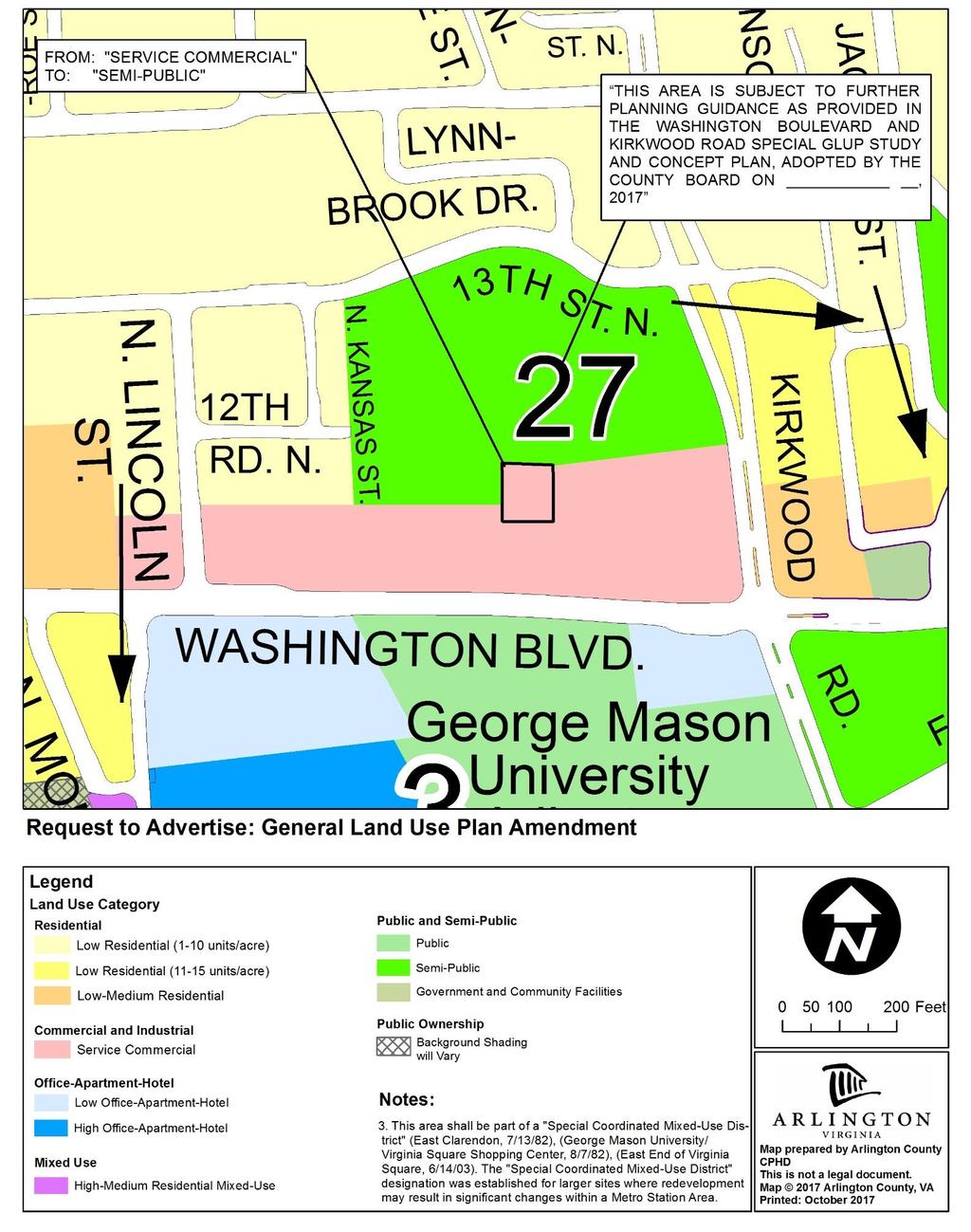
2 Square Metro Station Area and therefore lack any pertinent established County plans or policies to guide decisions on the requests, staff initiated a Special GLUP Study to address these requests. With three concurrent requests for contiguous properties, staff established a broader area and scope of study, thereby distinguishing it as a Special GLUP Study Plus. The study area is situated along the edge of Virginia Square where it transitions to lower density residential neighborhoods to the north. Given these circumstances, the study needed to address the fundamental question of whether potential increases in development intensity are appropriate here to encourage the area s transition into a more transit- and pedestrian-oriented place that is compatible with and sensitive to its context. During the study, residents and other stakeholders shared a variety of interests and concerns related to the requested GLUP amendments and staff analyses. Much of the community input that staff received during the process focused on several key common themes, including: 1) support for the YMCA Arlington branch s ability to modernize and expand its offerings; 2) concerns about the potential adverse effects on neighborhood character; 3) the possibility of increased traffic in and around the neighborhood; and 4) the potential loss of community-serving amenities. SUMMARY: Staff recently completed a Special General Land Use Plan ( GLUP ) Study Plus to address three individual requests to amend the GLUP for sites located northwest of the Washington Boulevard and Kirkwood Road intersection, and outside of the Virginia Square Metro Station Area (See Map 1). The requested GLUP changes are described in Table 1. If approved, each applicant would also propose in the future associated rezoning requests to support site plan special exception applications to pursue redevelopment. Map 1. Study Area, Washington Boulevard and Kirkwood Road Special GLUP Study "Plus" - 2 -
3 Table 1. Description of Formally Submitted GLUP Amendment Requests, Washington Boulevard and Kirkwood Road Special GLUP Study Plus Site Existing GLUP Requested GLUP Existing Zoning Requested Zoning Eleventh Street Development Service Commercial Medium O-A-H C-2 C-O-2.5 American Legion/APAH Service Commercial Medium O-A-H C-2 C-O-2.5 YMCA Semi-Public Medium Residential R-6 TBD Based on staff s analysis of relevant planning documents, adopted policies, and input provided by the Long Range Planning Committee ( LRPC ) of the Planning Commission through a special review process involving five (5) meetings, staff finds that potential GLUP amendments could be appropriate across the study area. Furthermore, staff is proposing that the County Board consider the adoption of the Washington Boulevard and Kirkwood Road Special GLUP Study Plus and Concept Plan, to establish it as the County s planning and policy guidance for the area. As detailed in this report, the Study Plus and Concept Plan and potential associated GLUP amendments are intended to: Update the County s vision for this area to support development that provides an important and sensitive transitioning down of building heights and densities from the Virginia Square Metro Station Area towards surrounding single-family residential neighborhoods; and Allow for redevelopment of mid-20 th century automobile-oriented service commercial and institutional properties with mixed-use, pedestrian-oriented development. BACKGROUND: In 2008, the County Board adopted the Policy for Consideration for General Land Use Plan (GLUP) Amendments Unanticipated by Previous Planning Efforts which calls for a community review process where a requested land use change is either lacking or inconsistent with guidance set forth in an adopted plan. This policy was established to ensure that unanticipated GLUP amendment requests are thoroughly reviewed to evaluate their appropriateness, prior to and independent of a specifically defined site plan application review. Located outside of the Virginia Square Metro Station Area, the three subject sites are not materially addressed by the 2003 Virginia Square Sector Plan or any other pertinent planning documents. Therefore, staff needed to undertake a Special GLUP Study to evaluate the requests. In addition, the concurrent timing and contiguous relationship of the sites led staff to expand the scope and area of study (thereby adding the Plus component to this study). The main purposes of the study included: 1) Envisioning the preferred future character and planning elements for this area; and 2) Determining whether the County Board should consider future GLUP amendments to support the implementation of the vision reflected in the findings of the study. DISCUSSION: For this study, Department of Community Planning, Housing and Development (DCPHD) staff, in conjunction with staff from the Department of Environmental Services (DES) and Department of Parks and Recreation (DPR), initiated a review process led by the LRPC. At its first meeting, the LRPC reviewed materials and provided input to staff that helped to validate the proposed scope and process for the study. The Washington Boulevard and Kirkwood Road Special GLUP Study "Plus" was addressed by the LRPC at five (5) of its meetings, held between October 2016 and July These meetings involved staff presentations of its analysis and - 3 -
4 related materials and corresponding LRPC discussion. Several meetings also included opportunities for public comment. Adoption of the Study Plus and Concept Plan: In concluding the LRPC review of the study, staff prepared a Washington Boulevard and Kirkwood Road Special GLUP Study Plus and Concept Plan document, which presents key information and analysis reviewed during the study, along with pertinent study findings, conclusions, and recommendations. Staff is recommending advertisement of future public hearings for County Board adoption of the Study Plus and Concept Plan document due to this study s more expansive scope and study area limits when compared with typical, single-site Special GLUP Studies. The adoption of this document does not imply or suggest a change in convention for how Special GLUP Studies are typically addressed. Rather, the adoption of the Study Plus and Concept Plan as County Board policy guiding future change in this area is particularly important because it: Provides a set of planning concepts and recommendations to guide future redevelopment across multiple properties in a coordinated fashion; Identifies and outlines guiding principles and other desirable elements that should be incorporated into future site plan applications for redevelopment on this block; and Documents and memorializes future GLUP amendments that could be considered for properties included within the study area but not yet subject to any GLUP request applications. The Study Plus and Concept Plan is organized as follows: Introduction; Site Analysis; Established Plans, Policies and Regulations; Framework Concept, Building Form and Massing Studies; Supporting Analyses; Guiding Principles; Plan Element Concept Maps; Recommendations Related to the Comprehensive Plan, and Study Findings and Conclusions. General Land Use Plan Amendments: The General Land Use Plan (GLUP) is the primary policy guide for future development in the County, and establishes the overall character, extent and location of various land uses. As discussed above, the primary impetus for this study was the submission of three individual requests to change the GLUP for sites within the study area. After extensive analysis, review, and consideration, staff proposes several near-term GLUP amendments. In addition, as described in the Washington Boulevard and Kirkwood Road Special GLUP Study Plus and Concept Plan, staff identifies additional potential changes to the GLUP that should be more fully considered in the context of prospective future special exception site plan and rezoning applications
5 In terms of near-term GLUP amendments, staff is proposing the following: Amend the GLUP map to add a note (27) identifying the Washington Boulevard and Kirkwood Road Special GLUP Study Plus and Concept Plan as a guiding document that further articulates the County s adopted future vision for this area; and Amend the GLUP for the Ball Family Burial Grounds from Service Commercial to Semi-Public. Aside from these two proposed changes, staff recommends that the GLUP generally remain unchanged for now. However, the County Board s adoption of the Study Plus and Concept Plan would identify GLUP designations that could incrementally be considered appropriate with future redevelopment proposals. This approach is in many ways consistent with the plan adoption and subsequent GLUP amendment process pertaining to the 2003 Rosslyn to Courthouse Urban Design Study (aka The In-Between Study ). Consistent with previously completed Special GLUP Studies, in November 2017 staff anticipates presenting to the County Board a recommendation pertaining to the advertisement of future public hearings for the three potential GLUP amendments associated with the sites subject to applications already filed with the County. For other study area sites that may be subject to future GLUP amendment applications, the advertising of such amendments (assuming there are consistent with the Study Plus and Concept Plan) could be addressed one to several months in advance of anticipated final consideration by the Planning Commission and County Board of associated site plan and rezoning applications. It is worth noting that during the LRPC process, there was a certain amount of discussion regarding the potential to establish a Special District on the GLUP map to help advance coordinated mixed-use growth in the study area. At that time, staff conducted research on other Special Districts on the GLUP to better understand the potential logic and appropriateness of establishing such a district as a result of this study. Through this research, staff generally found that most if not all Special Districts on the GLUP typically have at least two main components: 1) A defined list of planning goals and principles (and sometimes guidelines) that reinforce the County s vision for an area; and 2) special zoning and implementation tools to support that vision. In this case, staff concluded that the creation of a Special District on the GLUP without coupling it with special zoning and implementation tools is generally inconsistent with established practice. Furthermore, if adopted by the County Board, the Study Plus and Concept Plan would be as equally effective in guiding future change in this area. For these reasons, staff does not recommend the establishment of a Special District on the GLUP as a result of this study. In terms of potential longer-term GLUP amendments to be considered with individual site plan and rezoning applications, additional details are provided later in the Public Engagement section of this report. Master Transportation Plan Amendments: The Master Transportation Plan (MTP) promotes effective travel and accessibility for the County s residents, workers and visitors; provides a policy framework to guide the development - 5 -
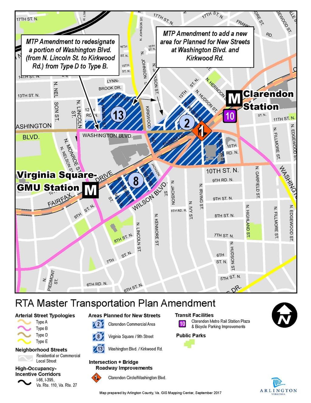
6 of projects and programs; advances the County s goals and objectives; and helps direct infrastructure investment. The County anticipates future changes within the designated study area, that will include the construction of new local streets, and new development form and uses. As such, Staff proposes the following amendments to the MTP Map to reflect recommendations of the Washington Boulevard and Kirkwood Road Special GLUP Study Plus and Concept Plan. Amend the MTP Map to designate Washington Boulevard between Kirkwood Road and North Lincoln Street as a Type B (Primarily Urban Mixed - Use) arterial street; and Amend the MTP Map to designate a new area #13 classified Areas Planned for New Streets, Washington Boulevard & Kirkwood Road Area. The planning study proposes a future vision for a mix of land uses on the north side of Washington Boulevard that are more urban in scale than the current development. Consequently, that section of Washington Boulevard when redeveloped, will more closely match the Type B, (Primarily Urban Mixed-Use) designation than its present Type D (Primarily Garden apartments and Townhomes) designation. Revising the street typology designation will provide useful guidance on the intended street design for anticipated future development proposals. The specifics of the new street locations and typologies will be determined through the development process and as more detailed analysis of the existing conditions and proposed development occurs. As physical changes are approved as part of site plan redevelopment projects for parcels within the study area, additional MTP amendments will be needed in the future to reflect those new streets as proposed for addition to the County s inventory. This approach is consistent with other Areas Designated for New Streets following adoption of new sector or area plans. Development of new streets and transportation infrastructure within the study area should be consistent with the County s MTP policies. PUBLIC ENGAGEMENT: Consistent with other Special GLUP Studies, this study included an iterative process involving five LRPC meetings to review and discuss staff-generated materials. However, given the Plus component of this Special GLUP Study, the composition of LRPC participants was expanded to include other stakeholders and representatives beyond just the Planning Commission and host civic association for the site. Participants represented at each of the LRPC meetings included: The LRPC of the Planning Commission; Ballston-Virginia Square Civic Association; Transportation Commission; Park and Recreation Commission; Historical Affairs and Landmark Review Board; and One representative of each development team that filed a requested GLUP amendment. In addition, staff hosted a community walking tour and open house on May 1, 2017, with more than 75 participants. Following the study area s perimeter, the walking tour allowed the - 6 -
7 community (including LRPC members) to get a better sense of existing conditions and potential spatial relationships of features across the study area and its surroundings. Immediately following the walking tour, staff hosted an open house at the YMCA facility on 13 th Street North. Staff hosted the open house with display materials (set 1 and set 2) to inform interested parties about the study, preliminary concepts and in-progress analyses, as well as to solicit public input on what they did and didn t like about the work in-progress. Each of the five LRPC meetings included an agenda that focused exclusively on the Washington Boulevard and Kirkwood Road Special GLUP Study "Plus". Generally, the meeting agendas followed the typical Special GLUP Study format where LRPC input on staff presentations leads to further analysis and revised modeling and other products, of which revised versions are shared by staff in subsequent meetings. A summary outline of the topics addressed at each of the LRPC meetings is presented in Table 2. Staff also established a project web page to support the LRPC process. The web page provides a summary and brief background on the impetus for the study, while also providing full access to meeting materials, including staff presentations, draft materials, and meeting summaries. The presence of the web page also provided a means of making the process and study progress more accessible to those unable to attend meetings in-person. The web page also provides access to compendium documents of all written correspondence sent from members of the public to staff between LRPC meetings. Table 2. Summary of LRPC Meeting Dates and Agenda Items Washington Boulevard and Kirkwood Road Special GLUP Study Plus Date Primary Agenda Items Materials October 20, 2016 (LRPC #1) Overview of Study Draft Scope/Process Site Analysis / Study Background Presentation Meeting Summary December 20, 2016 (LRPC #2) February 21, 2017 (LRPC #3) May 18, 2017 (LRPC #4) July 25, 2017 (LRPC #5) Framework Concept Studies Preliminary 3D Modeling LRPC #1 Follow-Up Transportation Analysis Refined Framework Concepts Refined 3D Modeling Draft Guiding Principles LRPC #2 Follow-Up Refined Framework Concepts Refined 3D Modeling LRPC #3 Follow-Up Recommended Framework Concept Final 3D Modeling Draft Special GLUP Study Document LRPC #4 Follow-Up Presentation Meeting Summary Presentation Meeting Summary Presentation Meeting Summary Presentation Meeting Summary - 7 -
8 Key Issues from LRPC Discussions and Community Input Through their discussions, LRPC members conveyed support for potential GLUP amendments for mixed-use redevelopment within the study area. However, by the conclusion of LRPC Meeting #5, there was no clear consensus on a specific GLUP designation, or for related Study Plus and Concept Plan recommendations for maximum building heights, specific density limits, and transportation and open space infrastructure recommendations. In fact, for some topic areas, there appeared to be notable differences of opinion either among LRPC members, that included representatives from the three applicants, or with the alternatives and preliminary recommendations by staff. This section of the report outlines and discusses key issue areas that were consistently raised through the LRPC and community conversations. Circulation and Access Options: Throughout the study, LRPC and staff considered both opportunities and challenges associated with potentially introducing additional circulation and access into and through the study area. Early in the process, staff shared preliminary public realm framework concepts to facilitate discussion about the desired degree and location of potential circulation and access enhancements. Periodic input from LRPC and the community led to further iterations and refinements of these concepts for further discussion. In considering circulation and access, staff relied upon County-adopted Master Transportation Plan (MTP) policies that call for maintaining and enhancing a grid-style street network. More specifically, MTP Streets Policy #6 calls for Enhanc(ing) the connectivity of the existing street network by constructing new streets with redevelopment of large blocks and avoiding permanent closures or other reductions in street connectivity. With a study area of over eight (8) acres primarily across one block, potential future redevelopment in this area presents the opportunity to coordinate additions and enhancements to the street network, consistent with MTP policies. In fact, since the MTP was updated in 2007, the County has approved and realized the addition of new streets with many site plans and phased-development site plans comparable to or smaller in size than the subject study area. A few examples of the general benefits that additional street connectivity through the block could provide in this instance include: Enhanced multi-modal circulation; Broader distribution of loading, parking access, on-street parking and other curbside uses; Expansion of the public realm that also achieves additional light and air between buildings and appropriate block and building scale; Improved public access and ensuring public street frontage to the Ball Family Burial Grounds; and Emergency and fire access. Despite MTP policies and the recognized benefits of street connectivity, input from most LRPC members and the community generally supported a more limited introduction of access into the study area block, with minimal or no planned vehicular connectivity across properties. During the LRPC discussions and other conversations, those advocating for stub streets (or a disconnected street network) and/or alleys instead of new inter-connecting streets shared the following reasons for doing so: - 8 -
9 Concerns that new street connections between Washington Boulevard or Kirkwood Road to 13 th Street North would increase traffic in the neighborhood; Framework concepts with full through connections would result in wider than necessary rights-of-way with more impervious surface; and Narrower stub streets/alleys would allow for larger building footprints, which could allow lower building heights to meet the study s target levels of density. The Washington Boulevard and Kirkwood Road Special GLUP Study Plus and Concept Plan includes a circulation and public spaces concept plan that proposes additional circulation into and through the block to serve the transportation and service needs of future development, while advancing County MTP goals and policies in the area. The exact location, widths, and elements of any new streets or connections will be determined through the evaluation of individual development proposals within the study area, based upon the conceptual recommendations set forth in the Study Plus and Concept Plan. As discussed earlier in the report, staff is also proposing Master Transportation Plan amendments to show the subject study area as an area planned for new future streets through the addition of cross-hatching on the MTP Streets Typology Map. Parking and Other Transportation Impacts: The potential for future redevelopment within the study area to increase parking demand on neighborhood streets was another transportation-related concern raised by nearby residents during the study. The study area is located within Residential Permit Parking (RPP) District #6, which comprises portions of the Ballston-Virginia Square Civic Association and the Lyon Village Civic Association. Based on current policies and practice, residents of special exception site plan buildings are ineligible to participate in the RPP program, as site plan project parking demands are generally expected to be met through the parking provided on-site. Nevertheless, neighbors raised concerns that residents and/or visitors of site plan buildings may add to the onstreet parking demand in RPP areas when RPP restrictions are not in effect. Members of the surrounding neighborhood have contacted staff to explain that these parking-related concerns have increased given the moratorium currently in place for any requests related to RPP program additions or revisions, pending the outcome of further study of the program to identify potential enhancements. Public Open Spaces and Landscape and Cultural Resources: The study area s existing conditions include several important landscape and cultural resources. As an outcome of the planning analysis and discussions during the LRPC process, a new public open space opportunity has also been identified, as a potential benefit to both the community, as well as people associated with potential future development on-site. These resources and related recommendations are addressed in greater detail below. Ball Family Burial Grounds: Established in the late 1700s the Ball Family Burial Grounds (BFBG) is one of Arlington s oldest family burial grounds. The BFBG holds the remains of the Ball family, which included some of Arlington s first settlers. The site was located on the Horatio Ball family farm in a predominantly rural setting up until the 1900s; soon thereafter Clarendon and its surroundings - 9 -
10 saw rapid residential and commercial development. These changes influenced the cemetery s setting and today it is generally surrounded by commercial development. The cemetery was designated as one of Arlington s first local historic districts by the County Board in It is one of three Ball family cemeteries so designated by the County. Any alterations to the cemetery require review and approval by the Historical Affairs and Landmark Review Board through a separate public review process. The existing commercially-focused GLUP and zoning designations are incompatible with the site s status as an historic cemetery, and should be amended as part of this effort. Throughout the process, there has been general support for maintaining and enhancing the BFBG as an important cultural and historic resource of the study area. LRPC discussion acknowledged that the adjacent setting of the cemetery can be significantly improved. Furthermore, study participants also recognized the potential opportunity to create additional relief around the cemetery by repurposing some of the undeveloped land abutting the BFBG as a landscaped buffer. These aspirations and goals related to the BFBG should be further studied and advanced in conjunction with redevelopment proposals abutting the cemetery. Mature Trees along 13 th Street North: The site analysis completed by staff at project initiation also documented the presence of a mature and generally healthy stand of trees along 13 th Street North, including Willow Oak, Southern Magnolia, and Post Oak trees. Subsequently, staff also discovered that this particular stand of trees was originally planted in the mid-1970s as part of a settlement agreement between the YMCA and several former neighbors residing to the north. Furthermore, that agreement requires the YMCA to maintain these trees (in addition to other outside and inside elements of its property) with no identified sunset. Given these factors, staff s analysis and modeling consistently presumed the retention and preservation of these trees. As such, the Study Plus and Concept Plan recommends the preservation of these trees and includes strategies to showcase the tree stand as part of the overall experience of the site. Planned Public Open Space: Beyond existing landscape features, the Study Plus and Concept Plan also recommends the addition of a public open space to be generally located in the northwestern limits of the study area. LRPC discussions and other community conversations recognized that a public open space at this location could advance several important goals. First, it could serve as a useable open space for Arlington residents. Second, this space could also be used to support, if appropriate, YMCA offerings that might benefit from access to an outdoor space. Third, the location of this potential open space (in an area where a parking lot exists today) would allow it to play an important role in achieving a sensitive and harmonious transition in scale and character between potential development on the site and the established single-family residential neighborhood. While various participants expressed sometimes differing opinions about the most important role of this space (usable park versus neighborhood transition), the general idea of a public open space at this location was consistently supported in LRPC discussions
11 Building Heights: The topic of potential building heights across the study area was extensively discussed during LRPC discussions and addressed via other means of community input. During the study, staff heard various perspectives regarding building heights, ranging from the sentiment that buildings should continue stepping-down in heights as they get farther away from Metro, to the idea that consideration should be given to heights that match the maximum number of floors capable of being built using primarily wooden frame construction (over a concrete podium). The numerous staff-generated building height and form massing studies facilitated extensive LRPC discussion on the topic. The building height recommendations set forth in the Study Plus and Concept Plan respond to the need for, and set forth strategies for achieving appropriate transitions in building height across the study area. To manage the transition across Washington Boulevard, the building heights concept map generally recommends up to six (6) stories of building height between Kirkwood Road and the signalized intersection east of North Lincoln Street, and up to five (5) stories west of that same intersection. These recommended heights recognize the taller permissible building heights south of Washington Boulevard, and the downward transition westward recognizes both the varied topography across the study area, and the desire to transition down to the existing five (5)-story Wentworth residential building located immediately west of the study area. For these five and six story height zones, corresponding absolute height limits of 60 and 70 feet, respectively, are recommended to provide for taller than typical ground floor heights (if so desired) while avoiding situations where office development (with taller floor heights) would exceed the dimensional heights that staff found to generally be acceptable through the study. Closest to adjacent single-family residences, the building heights concept map includes a deliberate step-down in height to aid with the desired transition. For sites fronting Washington Boulevard with northern property boundaries abutting single-family residential lots, there would be a transitional height area with a three (3)-story, 35-foot limit. Where the study area transitions to single-family lots to the west, the Study Plus and Concept Plan recommends a four-story height limit (not to exceed 45-feet). This four-story height limit is also maintained along 13 th Street North to assist with the transition to that neighborhood edge, including the Lynbrook townhome community, residents of which have advocated for any development along 13 th Street North to comprise townhouse development in this area. Except for four-stories at the corner of 13 th Street North, the recommended limit of six-stories along Kirkwood Road recognizes the potential for additional height in this location due to site topography, relative elevation of townhouse buildings to the east, and the overall cross-section and character of Kirkwood Road. Development Densities and General Land Use Plan Designations: The appropriateness of potential planned development densities was another key area of discussion during the study. The iterative process of developing and refining computer-generated building form and massing models for LRPC review was also the primary means of informing and facilitating a discussion on whether increases above existing permitted densities in the study area could be appropriate, and if so, to what degree
12 As with the discussion on building heights, the LRPC conversations and input from the community conveyed varying opinions about the level of openness to considering additional density. Generally speaking, most LRPC members were open to considering additional development potential in the area above that permitted by the existing GLUP designations, so long as building heights were managed appropriately and adequate public space was wellincorporated. During LRPC discussions, participants also supported the idea that as with building heights, densities should generally continue to decrease and transition away as distances from Metro increase. Others, including several neighbors living in close proximity to the study area, were generally opposed to any consideration of additional density in the area, and would prefer to see any redevelopment of these properties be done in accordance with existing planning and zoning parameters. As set forth in the Study Plus and Concept Plan, staff recommends future consideration of GLUP amendments that could permit additional density with redevelopment within the study area, as generally described below: Properties primarily fronting Washington Boulevard located east of the signalized intersection with Founders Way and south of an imaginary line extending eastward from 12 th Road South could be considered for additional density at the levels typically associated with the Medium Office-Apartment-Hotel (O-A-H) GLUP designation; Properties fronting Washington Boulevard located west of the signalized intersection with Founders Way could be considered for additional density at the levels typically associated with the Low O-A-H GLUP designation; and The YMCA property primarily fronting 13 th Street North located north of an imaginary line extending eastward from 12 th Road South could be considered for additional density at the levels typically associated with the Low O-A-H GLUP designation (although uses should generally be limited to residential, and also public, civic and institutional uses may be considered although their appropriateness for this site will be evaluated on a case-by-case basis). The density and potential GLUP designation recommendations described above are based on the iterative staff analyses conducted throughout the process, and takes into consideration input from the LRPC and other stakeholders and community members. Also, during the study, several participants raised concerns about the results depicted in several form and massing models that applied the most generous assumptions regarding average residential unit size and bonus density amounts of potential development projects. In certain Medium O-A-H development scenario models, many participants saw effective densities approaching 4.0 Floor Area Ratio (FAR) as excessive and beyond appropriate for the study area s location and context. To address these concerns, staff further refined several form and massing models based on lesser average unit size and bonus density assumptions. These refinements resulted in approximately 25% reductions in potential density yield, demonstrating that densities in the range of 2.5 to 3.0 FAR could be an appropriate fit for the southeastern most portions of the study area. To ensure that effective densities are carefully managed and kept within appropriate levels for prospective projects in areas that could be considered for Medium O-A-H, the building height recommendations in the concept plan have been thoughtfully and carefully established. If these
13 building heights are not followed closely, prospective future projects could pursue density levels in excess of what may be appropriate for these sites. In a typical Special GLUP Study, the conventional timing of GLUP related actions first includes County Board approval of the advertisement of future public hearings, which is an important step following the LRPC review of the study. When such hearings are approved for advertisement, the final action of the requested GLUP amendment is taken up concurrent with final actions on the site plan and rezoning applications, which often times can be many months following the approval of the advertisement. Given the concurrent application of three requests for GLUP amendments, and the proposal for the County Board to ultimately adopted the Study Plus and Concept Plan, this process is somewhat atypical. As such, staff anticipates that as part of the November 2017 package of related items for County Board action outlined in this report, a request to authorize advertisement of the three requested GLUP changes that are subjects to formal applications would also be included for consideration. Advisory Commission and Civic Association Input This section of the report summarizes input provided to staff from pertinent civic associations and advisory commissions participating in this study. Ballston-Virginia Square Civic Association The subject site is located within the Ballston Virginia Square Civic Association (BVSCA). As previously mentioned, a representative of BVSCA leadership participated in all five LRPC meetings related to this study. Between LRPC meetings, BVSCA leadership also submitted written comments to staff in response to presentations and discussions from the previous meeting. These comments, along with other written comments staff received during the study, are posted and available for review at the project web page. In addition to correspondence from BVSCA leadership, staff also received many written comments from other BVSCA residents and members of the broader community, also available for review via the project web page. In summary, some of the more common themes expressed through comments provided by BVSCA include: Concerns regarding building height, density, and bonus density; Concerns regarding the close proximity between some of the modeled building volumes and existing single-family homes; Interest in having specific protections for the single-family neighborhood while allowing for reasonable and responsible growth along Washington Boulevard; and Continued support for a new, state-of-the-art YMCA facility. Transportation Commission The Transportation Commission is scheduled to take up this item on its agenda at its October 5, 2017 meeting. Planning Commission The Planning Commission is scheduled to take up this item on its agenda at its October 10/11, 2017 meeting. Historical Affairs and Landmark Review Board The Historical Affairs and Landmark Review Board (HALRB) is scheduled to take up this item on its agenda at its October 18, 2017 meeting
14 Park and Recreation Commission The Park and Recreation Commission is scheduled to take up this item on its agenda at its October 24, 2017 meeting. CONCLUSION: Based on staff s analysis and the pertinent LRPC and community input provided throughout the study, staff recommends that the County Board authorize advertisement of future public hearings to consider the adoption of the Washington Boulevard and Kirkwood Road Special GLUP Study Plus and Concept Plan, associated GLUP Amendments, and associated MTP Amendments as outlined in this report. Authorizing the advertisement of public hearings on these amendments does not imply that the County Board supports the proposed changes
15 RESOLUTION TO AUTHORIZE ADVERTISEMENT OF PUBLIC HEARINGS AT THE PLANNING COMMISSION AND COUNTY BOARD MEETINGS TO BE HELD ON NOVEMBER 6, 2017, AND NOVEMBER 18, 2017, RESPECTIVELY, TO CONSIDER THE FOLLOWING: 1. ADOPTION OF THE WASHINGTON BOULEVARD AND KIRKWOOD ROAD SPECIAL GLUP STUDY PLUS AND CONCEPT PLAN, AS SHOWN IN ATTACHMENT A; 2. AMENDMENTS TO THE GENERAL LAND USE PLAN (GLUP) MAP, AS SHOWN IN ATTACHMENT B TO ADD NOTE 27 STATING THIS AREA IS SUBJECT TO FURTHER PLANNING GUIDANCE AS PROVIDED IN THE WASHINGTON BOULEVARD AND KIRKWOOD ROAD SPECIAL GLUP STUDY AND CONCEPT PLAN, ADOPTED BY THE COUNTY BOARD ON, 2017 ; AND TO AMEND THE DESIGNATION OF THE BALL FAMILY BURIAL GROUNDS FROM SERVICE COMMERCIAL TO SEMI- PUBLIC ; AND 3. AMENDMENTS TO THE MASTER TRANSPORTATION PLAN (MTP) MAP, AS SHOWN IN ATTACHMENT C, TO AMEND THE MAP ON THE FRONT SIDE OF THE MTP MAP TO AMEND THE MTP MAP TO DESIGNATE WASHINGTON BOULEVARD BETWEEN KIRKWOOD ROAD AND NORTH LINCOLN STREET AS A TYPE B (PRIMARILY URBAN MIXED-USE) ARTERIAL STREET; AND TO DESIGNATE A NEW AREA #13 CLASSIFIED AREAS PLANNED FOR NEW STREETS, WASHINGTON BOULEVARD AND KIRKWOOD ROAD AREA. The County Board of Arlington hereby resolves that the following items shall be advertised for public hearings by the Planning Commission on November 6, 2017, and the County Board on November 18, 2017, to consider: 1. Adoption of the Washington Boulevard and Kirkwood Road Special GLUP Study Plus and Concept Plan, as shown in Attachment A; 2. Amendments to the General Land Use Plan (GLUP) map, as shown in Attachment B to add Note 27 stating This area is subject to further planning guidance as provided in the Washington Boulevard and Kirkwood Road Special GLUP Study Plus and Concept Plan, adopted by the County Board on, 2017 ; and to amend the designation of the Ball Family Burial Grounds from Service Commercial to Semipublic ; and 3. Amendments to the Master Transportation Plan (MTP) map, as shown in attachment C, to amend the map on the front side of the MTP map to designate Washington Boulevard between Kirkwood Road and North Lincoln Street as a Type B (Primarily urban mixed-use arterial street, and to designate a new area #13 classified Areas Planned for New Streets, Washington Boulevard and Kirkwood Road Area
16 ATTACHMENT A SEE SEPARATE DOCUMENT TITLED: WASHINGTON BOULEVARD AND KIRKWOOD ROAD SPECIAL GLUP STUDY PLUS AND CONCEPT PLAN
17 ATTACHMENT B
18 ATTACHMENT C
ATTACHMENT. To the west, north, and east of the block, primarily singlefamily detached residential patterns, with some townhouses, predominate.
 COMMENT / REVISION MATRIX (as of ) for Washington and Kirkwood Special GLUP Study "Plus" and Concept Plan 1 2 Resolve inconsistency between American Legion site area noted in Map 1 1.36 AC 1.29 AC and
ARLINGTON COUNTY, VIRGINIA. County Board Agenda Item Meeting of February 23, 2019
 ARLINGTON COUNTY, VIRGINIA County Board Agenda Item Meeting of February 23, 2019 DATE: February 15, 2019 SUBJECT: Amendment to the Master Transportation Plan (MTP) Map to add a new section of North Kansas
ARLINGTON COUNTY, VIRGINIA
 ARLINGTON COUNTY, VIRGINIA County Board Agenda Item Meeting October 15, 2005 DATE: September 28, 2005 SUBJECT: Request to Advertise the adoption of the 2005 Clarendon Sector Plan C. M. RECOMMENDATION:
DEPARTMENT OF COMMUNITY PLANNING, HOUSING AND DEVELOPMENT Planning Division. Arlington County Planning Commission
 DEPARTMENT OF COMMUNITY PLANNING, HOUSING AND DEVELOPMENT Planning Division 2100 Clarendon Boulevard, Suite 700 Arlington, VA 22201 TEL 703.228.3525 FAX 703.228.3543 www.arlingtonva.us DRAFT TO: FROM:
ARLINGTON COUNTY, VIRGINIA. County Board Agenda Item Meeting of June 16, 2018
 ARLINGTON COUNTY, VIRGINIA County Board Agenda Item Meeting of June 16, 2018 DATE: June 7, 2018 SUBJECT: Z-2604-18-1 Rezoning from R-6 and R-5 Single Family Residential Districts to S-3A Special District
Washington Boulevard & Kirkwood Road SPECIAL GLUP STUDY PLUS and CONCEPT PLAN NOVEMBER 2017
 Washington Boulevard & Kirkwood Road SPECIAL GLUP STUDY PLUS and CONCEPT PLAN NOVEMBER 2017 Washington and Kirkwood Special GLUP Study PLUS AND CONCEPT PLAN a2 Washington Boulevard and Kirkwood Road Special
Washington Boulevard & Kirkwood Road SPECIAL GENERAL LAND U SE PLAN STU DY PLU S DRAFT JULY 21, 2017
 Washington Boulevard & Kirkwood Road SPECIAL GENERAL LAND U SE PLAN STU DY PLU S DRAFT JULY 21, 2017 Washington & Kirkwood Special GLUP Study PLUS a2 Washington Boulevard & Kirkwood Road Special GLUP Study
Multi-family Residential: 164, ,000 Sq. Ft. (approx. 172 Units) Single-family Residential 21 Units
 Single-family Residential 21 Units") Welcome to the Washington/Kirkwood Study Area, Scope, Special Existing GLUP Conditions Study Plus WELCOME! (Not advanced for further study beyond the December 2016 LRPC meeting) (Not advanced for further
Welcome to the Washington/Kirkwood Study Area, Scope, Special Existing GLUP Conditions Study Plus WELCOME! (Not advanced for further study beyond the December 2016 LRPC meeting) (Not advanced for further
TO: FROM: SUBJECT: Background
 TO: FROM: SUBJECT: Long Range Planning Committee and Zoning Committee of the Planning Commission Kellie Brown and Margaret Rhodes, Planning Division, CPHD DATE: June 8, 2017 Courthouse Square Implementation
1.0 Purpose of a Secondary Plan for the Masonville Transit Village
 Report to Planning and Environment Committee To: Chair and Members Planning & Environment Committee From: John M. Fleming Managing Director, Planning and City Planner Subject: Masonville Transit Village
ARLINGTON COUNTY, VIRGINIA
 ARLINGTON COUNTY, VIRGINIA County Board Agenda Item Meeting of March 20, 2007 SUPPLEMENTAL REPORT #2 Additional and Revised Information DATE: March 20, 2007 SUBJECT: Request to Advertise Public Hearings
Urban Planning and Land Use
 Urban Planning and Land Use 701 North 7 th Street, Room 423 Phone: (913) 573-5750 Kansas City, Kansas 66101 Fax: (913) 573-5796 Email: planninginfo@wycokck.org www.wycokck.org/planning To: From: City Planning
ARLINGTON COUNTY, VIRGINIA
 ARLINGTON COUNTY, VIRGINIA County Board Agenda Item Meeting of July 21, 2012 DATE: July 12, 2012 SUBJECT: SP #416 SITE PLAN AMENDMENT to modify condition #6 to eliminate requirement to provide a pedestrian
Official Plan Review: Draft Built Form Policies
 PG.30.1 REPORT FOR ACTION Official Plan Review: Draft Built Form Policies Date: May 15, 2018 To: Planning and Growth Management Committee From: Chief Planner and Executive Director, City Planning Division
CITY OF CHARLOTTESVILLE, VIRGINIA CITY COUNCIL AGENDA
 CITY OF CHARLOTTESVILLE, VIRGINIA CITY COUNCIL AGENDA Agenda Date: December 16, 2013 Action Required: Adoption of Resolution Presenter: Staff Contacts: Title: James E. Tolbert, AICP, Director of NDS James
ARLINGTON COUNTY, VIRGINIA
 ARLINGTON COUNTY, VIRGINIA County Board Agenda Item Meeting of September 19, 2015 DATE: September 11, 2015 SUBJECTS: Outdoor Café at Citizen Burger Bar A. SP# 418 Site Plan Amendment to modify an approved
FOUR MILE RUN VALLEY WORKING GROUP AND CHARGE
 FOUR MILE RUN VALLEY WORKING GROUP AND CHARGE Adopted April 16, 2016 Amended July 19, 2016 Overview of Integrated Effort The overall goal of the Four Mile Run Valley (4MRV) initiative is to develop a comprehensive
CRYSTAL CITY BLOCK PLAN # CCBP- G 1 DRAFT
 CRYSTAL CITY BLOCK PLAN # CCBP- G 1 DRAFT BLOCK G (Metro Market Square block) Long Range Planning Committee Meeting January 29, 2018 1 1. Introduction 2 1. LRPC Meeting Purpose Review of proposed Crystal
ARLINGTON COUNTY, VIRGINIA
 ARLINGTON COUNTY, VIRGINIA County Board Agenda Item Meeting of April 12, 2014 DATE: April 2, 2014 SUBJECT: to the Arlington County Zoning Ordinance, Article 11.1 "CP-FBC" Columbia Pike Form Based Code
Edward R. Sajecki Commissioner of Planning and Building
 Corporate Report Clerk s Files Originator s Files CD.03.POR DATE: TO: FROM: SUBJECT: Chair and Members of Planning and Development Committee Meeting Date: February 27, 2012 Edward R. Sajecki Commissioner
THAT the attached Terms of Reference for the Thornhill Centre Street Study be approved.
 COMMITTEE OF THE WHOLE AUGUST 18, 2003 THORNHILL CENTRE STREET STUDY PLANNING FILE: 15.92 Recommendation The Commissioner of Planning recommends: THAT the attached Terms of Reference for the Thornhill
ARLINGTON COUNTY PLANNING COMMISSION SITE PLAN REVIEW COMMITTEE SITE PLAN CHAIR GUIDE
 ARLINGTON COUNTY PLANNING COMMISSION SITE PLAN REVIEW COMMITTEE SITE PLAN CHAIR GUIDE Excerpts from the SPRC Operating Guide, 1/31/04 Revised March 17,2010 1. Site Plan Chair Responsibilities 1 1, The
PLANNING IN ARLINGTON. Briefing to Katie Cristol
 1 PLANNING IN ARLINGTON Briefing to Katie Cristol Overview 2 Comprehensive Plan - Background Administration of the Comprehensive Plan Review of the Comprehensive Plan Implementation of the Comprehensive
ONTARIO MUNICIPAL BOARD
 PL 120483 ONTARIO MUNICIPAL BOARD Applicant/Appellant: 2124123 Ontario Limited Subject: OPA, Rezoning and Draft Plan of Subdivision Municipal Address: 3940 Highway 7 East Municipality: City of Markham
ARLINGTON COUNTY, VIRGINIA
 ARLINGTON COUNTY, VIRGINIA County Board Agenda Item Meeting of March 10, 2012 DATE: February 29, 2012 SUBJECT: SP #197 SITE PLAN AMENDMENT to add a new condition #25 to allow a new use for a Yoga and Pilates
PART 1. Background to the Study. Avenue Study. The Danforth
 The Danforth 1.1/ Study Purpose & Key Municipal Goals 1.2/ The Local Advisory Committee 1.3/ The Project Team 1.4/ Study Process/Summary of Method 1.5/ Summary of Consultation 1.1 Study Purpose and Key
Bloor St. W. Rezoning - Preliminary Report
 STAFF REPORT ACTION REQUIRED 1638-1644 Bloor St. W. Rezoning - Preliminary Report Date: April 1, 2008 To: From: Wards: Reference Number: Toronto and East York Community Council Acting Director, Community
Review of Opportunity Area C Draft Comprehensive Plan and Draft BOS Follow-On Motions. Special Working Group Meeting March 4, 2015
 Review of Opportunity Area C Draft Comprehensive Plan and Draft BOS Follow-On Motions Special Working Group Meeting March 4, 2015 The slides that follow identify where the draft Comprehensive Plan has
Staff Report and Recommendation
 Community Planning and Development Planning Services 201 W. Colfax Ave., Dept. 205 Denver, CO 80202 p: 720.865.2915 f: 720.865.3052 www.denvergov.org/cpd TO: City Council Neighborhoods and Planning Committee
Courthouse Square Planning & Urban Design Study. Courthouse Square Working Group #13 October 15, 2014
 Courthouse Square Planning & Urban Design Study Courthouse Square Working Group #13 October 15, 2014 1 Courthouse Square Process Working Group Community Courthouse Square Advisory Groups & Civic Associations
Arlington County Long Range Planning Committee Meeting
 Arlington County Long Range Planning Committee Meeting Preliminary FY2015 Planning Division Work Program A presentation by the Arlington County Department of Community Planning, Housing and Development,
ROAD CLOSURE AND LAND USE AMENDMENT SILVER SPRINGS (WARD 1) NORTHEAST OF NOSEHILL DRIVE NW AND SILVER SPRINGS ROAD NW BYLAWS 2C2018 AND 29D2018
 NORTHEAST OF NOSEHILL DRIVE NW AND SILVER SPRINGS ROAD NW BYLAWS 2C2018 AND 29D2018") Page 1 of 19 EXECUTIVE SUMMARY This application proposes redesignating two parcels in the community of Silver Springs from Special Purpose Future Urban Development (S-FUD) District and undesignated road
Page 1 of 19 EXECUTIVE SUMMARY This application proposes redesignating two parcels in the community of Silver Springs from Special Purpose Future Urban Development (S-FUD) District and undesignated road
Crofton Manor 2803 West 41st Avenue WHAT WE HEARD. Public Consultation: Phase 1
 Crofton Manor 2803 West 41st Avenue WHAT WE HEARD Public Consultation: Phase 1 Background CROFTON MANOR What s Happening The City of Vancouver is undertaking a planning and public engagement process to
Welcome. Walk Around. Talk to Us. Write Down Your Comments
 Welcome This is an information meeting introducing the applications for proposed redevelopment of the Yorkdale Shopping Centre site at 3401 Dufferin Street and 1 Yorkdale Road over the next 20+ years,
Arlington County Retail Plan
 Arlington County Retail Plan Draft April 28, 2015 EXECUTIVE SUMMARY Arlington will be a community where retail is convenient, appealing, activating and sustainable; that provides interest and authenticity,
John M. Fleming Managing Director, Planning and City Planner. Old East Village Dundas Street Corridor Secondary Plan Draft Terms of Reference
 Report to Planning and Environment Committee To: From: Subject: Chair and Members Planning & Environment Committee John M. Fleming Managing Director, Planning and City Planner Old East Village Dundas Street
Scope of Services. River Oaks Boulevard (SH 183) Corridor Master Plan
 Corridor Master Plan") Scope of Services River Oaks Boulevard (SH 183) Corridor Master Plan PROJECT AREA The project area consists of the River Oaks Boulevard (SH 183) corridor bounded by SH 199 at the northern end and the Trinity
Scope of Services River Oaks Boulevard (SH 183) Corridor Master Plan PROJECT AREA The project area consists of the River Oaks Boulevard (SH 183) corridor bounded by SH 199 at the northern end and the Trinity
City of Heath. Town Center Concept
 In the give-and-take of getting projects designed, financed, and approved, the famous refrain from the film Field of Dreams is heard often: if you build it, they will come. From the perspective of the
Courthouse Square Implementation Comment/Response Matrix
 Courthouse Square Implementation /Response Matrix 1 Are open space symbols binding? GLUP No, open space symbols are not binding, as the GLUP is a policy instrument illustrating the County s future vision
TO: Mayor & Council DATE: April 12, The Planning and Development Department and the Engineering Department recommend that Council:
 CORPORATE REPORT NO: R080 COUNCIL DATE: April 12, 2010 REGULAR COUNCIL TO: Mayor & Council DATE: April 12, 2010 FROM: SUBJECT: General Manager, Planning and Development General Manager, Engineering Neighbourhood
SUBJECT: Waterfront Hotel Planning Study Update TO: Planning and Development Committee FROM: Department of City Building. Recommendation: Purpose:
 Page 1 of Report PB-23-18 SUBJECT: Waterfront Hotel Planning Study Update TO: Planning and Development Committee FROM: Department of City Building Report Number: PB-23-18 Wards Affected: 2 File Numbers:
Town Center (part of the Comprehensive Plan)
") Town Center (part of the Comprehensive Plan) Mercer Island Town Center Looking North (2014) In 1994, a year-long process culminated in a set of design guidelines and code requirements for the Town Center
Town Center (part of the Comprehensive Plan) Mercer Island Town Center Looking North (2014) In 1994, a year-long process culminated in a set of design guidelines and code requirements for the Town Center
2.7 ac park. TOTAL 5,403 DU 1,297,900 sf 1,105,450 sf 3.87 ac 5,563 DU 1,121,200 sf 1,105,450 sf 3.87 ac
 PLAN AMENDMENT 2013-I-B1: SEVEN CORNERS SPECIAL STUDY Summary of Pre-staffing Comments Planner: Bernard Suchicital bsuchi@fairfaxcounty.gov (703) 324-1254 Background On October 29, 2013, the Board of Supervisors
CITY OF VAUGHAN EXTRACT FROM COUNCIL MEETING MINUTES OF NOVEMBER 15, 2016
 Item 11, Report No. 38, of the Committee of the Whole, which was adopted without amendment by the Council of the City of Vaughan on November 15, 2016. Regional Councillor Di Biase declared an interest
12 January 12, 2011 Public Hearing APPLICANT: TAILWIND DEVELOPMENT GROUP,LLC PROPERTY OWNER: CITY OF VIRGINIA BEACH
 12 January 12, 2011 Public Hearing APPLICANT: TAILWIND DEVELOPMENT GROUP,LLC PROPERTY OWNER: CITY OF VIRGINIA BEACH STAFF PLANNER: Faith Christie REQUEST: Conditional Change of Zoning (from PD-H1 Planned
NORTH QUINCY STREET P LAN ADDENDUM DRAFT:
 NORTH QUINCY STREET P LAN ADDENDUM DRAFT: 09-10-2012 a2 North Quincy Street Plan Addendum DRAFT 9-10-2012 2012 North Quincy Street Plan Addendum DRAFT TABLE OF CONTENTS PAGE I. INTRODUCTION...1 Background...1
Introduction. Chapter 1. Purpose of the Comprehensive Plan Plan Organization Planning Process & Community Input 1-1
 Chapter 1 Introduction Lakewood 2025: Moving Forward Together Purpose of the Comprehensive Plan Plan Organization Planning Process & Community Input 1-1 Purpose of the Comprehensive Plan The Comprehensive
Staff Report to the North Ogden City Planning Commission
 Staff Report to the North Ogden City Planning Commission SYNOPSIS / APPLICATION INFORMATION Application Request: Concept review on a legislative application to rezone land located at approximately 1750
South of Eastern Strategic Direction Status Update
 STAFF REPORT ACTION REQUIRED South of Eastern Strategic Direction Status Update Date: July 10, 2014 To: From: Planning and Growth Management Committee Chief Planner and Executive Director, City Planning
INDEPENDENCE BOULEVARD AREA PLAN. June 24, 2008
 INDEPENDENCE BOULEVARD AREA PLAN Public Meeting #1 June 24, 2008 Tonight s Agenda Introduction Welcome and Ground Rules Overview Presentation Purpose of the Plan What Brings Us Here? A Tour of the Corridor
SUBJECT: GO Station Mobility Hubs Preferred Concepts: Aldershot GO, Burlington GO and Appleby GO. Planning and Development Committee - Public Meeting
 Page 1 of Report PB-76-17 SUBJECT: GO Station Mobility Hubs Preferred Concepts: Aldershot GO, Burlington GO and Appleby GO TO: FROM: Planning and Development Committee - Public Meeting Planning and Building
DRAFT Subject to Modifications
 TREASURE COAST REGIONAL PLANNING COUNCIL M E M O R A N D U M To: Council Members AGENDA ITEM 8 From: Date: Subject: Staff May 19, 2017 Council Meeting Florida Department of Transportation Complete Streets
PSRC REVIEW REPORT & CERTIFICATION RECOMMENDATION
 PSRC REVIEW REPORT & CERTIFICATION RECOMMENDATION KITSAP COUNTY COUNTYWIDE PLANNING POLICIES July 2, 2012 BACKGROUND A major emphasis of the Washington State Growth Management Act (GMA) is the need to
WHEREAS, the current Comprehensive Plan was adopted in 2005; and
 RESOLUTION 2018-06 RESOLUTION TO AMEND THE CITY S COMPREHENSIVE PLAN TO (1) AMEND CHAPTER 4 TO ADD A SPECIAL REVITALIZATION DISTRICT FOR EDUCATION AND ECONOMIC DEVELOPMENT ; (2) DESIGNATE ON THE FUTURE
Plan Overview. Manhattan Area 2035 Reflections and Progress. Chapter 1: Introduction. Background
 Plan Overview The Manhattan Urban Area Comprehensive Plan (the Comprehensive Plan) is a joint planning initiative of the City of Manhattan, Pottawatomie County, and Riley County. The 2014 Comprehensive
ARLINGTON COUNTY, VIRGINIA
 ARLINGTON COUNTY, VIRGINIA County Board Agenda Item Meeting of April 23, 2019 DATE: April 12, 2019 SUBJECT: SP #413 SITE PLAN AMENDMENT to permit a fixed bar in a private outdoor café space with associated
Queen Street West - Zoning Amendment Application - Preliminary Report
 STAFF REPORT ACTION REQUIRED 944-952 Queen Street West - Zoning Amendment Application - Preliminary Report Date: February 6, 2013 To: From: Wards: Reference Number: Toronto and East York Community Council
ARTICLE 6: Special and Planned Development Districts
 ARTICLE 6: Special and Planned Development Districts 6-10 Traditional Neighborhood Development (TND) District 6-10.10 Purpose and Intent The Traditional Neighborhood Development (TND) District provides
3. VISION AND GOALS. Vision Statement. Goals, Objectives and Policies
 Vision Statement Queen Creek s interconnected network of parks, trails, open spaces and recreation opportunities provide safe and diverse activities and programs that sustain its unique, small town, equestrian
S C O P E O F W O R K A P R I L
 white flint 2 sector plan S C O P E O F W O R K A P R I L 2 0 1 2 MONTGOMERY COUNTY PLANNING DEPARTMENT M-NCPPC MontgomeryPlanning.org 1 white flint 2 sector plan Scope of Work abstract This scope of work
Chapter 1.0 Introduction
 Chapter 1.0 Introduction 1.1 Background The North Metro commuter rail line is part of the RTD FasTracks regional transit system expansion program to build more than 100 miles of rail transit throughout
Appendix C: Interim Mixed-Use Evaluation Criteria
 Appendix C: Interim Mixed-Use Evaluation Criteria C-1 Appendix C: Interim Mixed-Use Evaluation Criteria PURPOSE: The implementation of numerous policies contained within the Master Plan hinges on the creation
Land Use Amendment in Southwood (Ward 11) at and Elbow Drive SW, LOC
 at and Elbow Drive SW, LOC") 2018 November 15 Page 1 of 10 EXECUTIVE SUMMARY This land use amendment application was submitted by Rick Balbi Architect on 2017 August 31 on behalf of Sable Developments Ltd, and with authorization from
2018 November 15 Page 1 of 10 EXECUTIVE SUMMARY This land use amendment application was submitted by Rick Balbi Architect on 2017 August 31 on behalf of Sable Developments Ltd, and with authorization from
ELMVALE ACRES SHOPPING CENTRE MASTER PLAN
 ELMVALE ACRES SHOPPING CENTRE MASTER PLAN Contents 1.0 INTRODUCTION... 2 2.0 LOCATION... 2 3.0 EXISTING CONTEXT... 2 4.0 VISION & GUIDING PRINCIPLES... 2 5.0 LAND USE AND BUILT FORM... 4 5.1 St. Laurent
FOUR MILE RUN VALLEY WORKING GROUP AND CHARGE Adopted April 16, 2016 Amended July 19, 2016
 FOUR MILE RUN VALLEY WORKING GROUP AND CHARGE Adopted April 16, 2016 Amended July 19, 2016 Working Group Charge The Working Group is charged by the County Board to collaborate with staff to provide commission,
9 CITY OF VAUGHAN OFFICIAL PLAN AMENDMENT NO BOCA EAST INVESTMENTS LIMITED
 9 CITY OF VAUGHAN OFFICIAL PLAN AMENDMENT NO. 631 - BOCA EAST INVESTMENTS LIMITED The Planning and Economic Development Committee recommends the adoption of the recommendations contained in the following
POLICY AMENDMENT AND LAND USE AMENDMENT KILLARNEY/GLENGARRY (WARD 8) NW CORNER OF RICHMOND ROAD AND 33 STREET SW BYLAWS 1P2015 AND 7D2015
 NW CORNER OF RICHMOND ROAD AND 33 STREET SW BYLAWS 1P2015 AND 7D2015") Page 1 of 13 EXECUTIVE SUMMARY This application seeks to redesignate an RC-2 (Residential Contextual One/Two Dwelling) parcel to MC-Gd72 (Multi-Residential Contextual Grade-Oriented) to allow for multi-residential
Page 1 of 13 EXECUTIVE SUMMARY This application seeks to redesignate an RC-2 (Residential Contextual One/Two Dwelling) parcel to MC-Gd72 (Multi-Residential Contextual Grade-Oriented) to allow for multi-residential
From: Sent: To: Subject: Zoning: Landscaping:
 From: Bernard H. Berne [mailto:bhberne@yahoo.com] Sent: Tuesday, May 15, 2012 1:18 AM To: CountyBoard Subject: May 19, 2012 County Board Meeting: Goodyear Site Plan (SP #72-650 N. Glebe Road) and amendment
13 THORNHILL YONGE STREET STUDY IMPLEMENTATION CITY OF VAUGHAN OPA 669 AND TOWN OF MARKHAM OPA 154
 13 THORNHILL YONGE STREET STUDY IMPLEMENTATION CITY OF VAUGHAN OPA 669 AND TOWN OF MARKHAM OPA 154 The Planning and Economic Development Committee recommends the adoption of the recommendations contained
Workshop 3. City of Burlington Waterfront Hotel Planning Study. September 14, The Planning Partnership
 Workshop 3 City of Burlington Waterfront Hotel Planning Study September 14, 2017 The Planning Partnership The Waterfront Hotel Planning Study 01 The Brant & Lakeshore Planning Study will establish a Strategic
Gold Line Bus Rapid Transit Transit Oriented Development (BRTOD) Helmo Station Area Plan
 Helmo Station Area Plan") Appendix F Gold Line Bus Rapid Transit Transit Oriented Development (BRTOD) Helmo Station Area Plan Introduction and Purpose of the Plan The Gold Line Bus Rapid Transit facility is an eleven-mile dedicated
Appendix F Gold Line Bus Rapid Transit Transit Oriented Development (BRTOD) Helmo Station Area Plan Introduction and Purpose of the Plan The Gold Line Bus Rapid Transit facility is an eleven-mile dedicated
VILLAGE OF BOLTON HERITAGE CONSERVATION DISTRICT PLAN
 Page 1 1. INTRODUCTION AND BACKGROUND 1.1 THE PROJECT VILLAGE OF BOLTON HERITAGE CONSERVATION DISTRICT PLAN TERMS OF REFERENCE The Town of Caledon (Town) is a large, predominantly rural municipality with
Report to: Development Services Committee Report Date: April 24, 2017
 SUBJECT: Cornell Rouge National Urban Park Gateway - Report on Design Charrette and Next Steps PREPARED BY: Lilli Duoba, MES, MCIP, RPP, Manager, Natural Heritage (ext. 7925) REVIEWED BY: Marg Wouters,
4780 Eglinton Avenue West - Zoning By-law Amendment and Draft Plan of Subdivision Applications - Preliminary Report
 STAFF REPORT ACTION REQUIRED 4780 Eglinton Avenue West - Zoning By-law Amendment and Draft Plan of Subdivision Applications - Preliminary Report Date: May 29, 2014 To: From: Wards: Reference Number: Etobicoke
City Council Special Meeting AGENDA ITEM NO. C.
 City Council Special Meeting AGENDA ITEM NO. C. DATE: 01/04/2019 TO: Honorable Mayor and City Council Members SUBJECT: Transit Villages Specific Plan project Study Session (Development Services Director
December 1, 2014 (revised) Preliminary Report -- Thomas Jefferson Site Evaluation
 Preliminary Report -- Thomas Jefferson Site Evaluation") December 1, 2014 (revised) TO: FROM: RE Arlington County Board Thomas Jefferson Site Evaluation Working Group by Carrie Johnson, Chair Preliminary Report -- Thomas Jefferson Site Evaluation The Thomas
December 1, 2014 (revised) TO: FROM: RE Arlington County Board Thomas Jefferson Site Evaluation Working Group by Carrie Johnson, Chair Preliminary Report -- Thomas Jefferson Site Evaluation The Thomas
Humber Bay Shores Precinct Plan Final Report
 STAFF REPORT ACTION REQUIRED Humber Bay Shores Precinct Plan Final Report Date: May 21, 2010 To: From: Wards: Reference Number: Etobicoke York Community Council Director, Community Planning, Etobicoke
Port Lavaca Future Land Use
 Port Lavaca Future Land Use Introduction The City of Port Lavaca is beginning to see sustained growth, after many years of relative stable population. New single family homes, apartments, and businesses
Slot Home Task Force Meeting #5 Phase 2 June 8, 2017
 Slot Home Task Force Meeting #5 Phase 2 June 8, 2017 MEETING OBJECTIVES Review Staff Recommended Strategy for Mixed Use and Main Street districts Confirm the Strategy for the Mixed Use and Main Street
North Fair Oaks Community Plan Summary and Information
 North Fair Oaks Community Plan Summary and Information WHAT IS THE NORTH FAIR OAKS COMMUNITY PLAN? The North Fair Oaks Community Plan is part of the San Mateo County General Plan, and establishes policies
WASHINGTON/KIRKWOOD SPECIAL GLUP STUDY PLUS MAY 1, 2017 OPEN HOUSE
 1. Results of Scenario Rating Scorecard (as of May 10, 2017) WASHINGTON/KIRKWOOD SPECIAL GLUP STUDY PLUS MAY 1, 2017 OPEN HOUSE 1. Results of Scenario Rating Scorecard (as of May 10, 2017) Scenario 2 -
A. WHAT IS A GENERAL PLAN?
 I. Introduction A. WHAT IS A GENERAL PLAN? A general plan is the planning guideline for the future of a city. It contains goals and policies which regulate urban development, the protection of the natural
Downtown Streetscape Manual & Built Form Standards
 City of Guelph Downtown Streetscape Manual & Built Form Standards July 2014 Prepared by Brook McIlroy Inc. in association with Unterman McPhail Associates and McCormick Rankin Inc. City of Guelph Downtown
Elfrida Growth Area Study
 Elfrida Growth Area Study Public Information Centre #2 December 6, 2017 6:00-8:30 pm PLANNING & ECONOMIC DEVELOPMENT DEPARTMENT Purpose of the Study The Elfrida Area has been identified as the preferred
Planning Commission Report
 Planning Commission Report To: From: Subject: Planning Commission Meeting: January 6, 2016 Agenda Item: 8-B Planning Commission David Martin, Planning & Community Development Director Introduction to the
4.1.3 LAND USE CATEGORIES
 4.1.3 LAND USE CATEGORIES a. City Center District The City Center District incorporates the existing character and mix of uses in downtown Belmont to encourage redevelopment and new development in keeping
Mill Woods Town Centre Proposed Rezoning LDA
 Mill Woods Town Centre Proposed Rezoning LDA15 0649 The City of Edmonton has received an application for rezoning and an amendment to the Mill Woods Station Area Redevelopment Plan (ARP) for the Mill Woods
SITE PLAN REVIEW COMMITTEE MEETING AGENDA
 Page 1 SITE PLAN REVIEW COMMITTEE MEETING AGENDA DATE: Tuesday, November 13, 2018 TIME: 7:00-8:30 p.m. PLACE: Bozman Government Center, 2100 Clarendon Blvd., Room 311 Arlington, VA 22201 SPRC STAFF COORDINATOR:
Policies and Code Intent Sections Related to Town Center
 Policies and Code Intent Sections Related to Town Center The Town Center Vision is scattered throughout the Comprehensive Plan, development code and the 1994 Town Center Plan. What follows are sections
THE GEORGE WASHINGTON UNIVERSITY MOUNT VERNON CAMPUS
 THE GEORGE WASHINGTON UNIVERSITY MOUNT VERNON CAMPUS CAMPUS PLAN AMENDMENT AND FURTHER PROCESSING APPLICATION: PRE-HEARING SUBMISSION PELHAM REPLACEMENT PROJECT FILED WITH THE ZONING COMMISSION OF THE
M E M O R A N D U M PLANNING AND COMMUNITY DEVELOPMENT DEPARTMENT CITY OF SANTA MONICA CITY PLANNING DIVISION
 M E M O R A N D U M PLANNING AND COMMUNITY DEVELOPMENT DEPARTMENT CITY OF SANTA MONICA CITY PLANNING DIVISION DATE: March 12, 2018 TO: FROM: SUBJECT: The Honorable Landmarks Commission Roxanne Tanemori,
Attachment 1 TOWN OF NEW TECUMSETH. Manual for the Preparation of an Urban Design Report
 Attachment 1 TOWN OF NEW TECUMSETH Manual for the Preparation of an Urban Design Report July 2010 TABLE OF CONTENTS Background, Policy Framework and the Preparation of Urban Design Reports 1. Introduction
Courthouse Square Planning & Urban Design Study
 Courthouse Square Planning & Urban Design Study Transit Advisory Committee October 14, 2014 Andrew D huyvetter, AICP, Associate Planner Center for Urban Design and Research Department of Community Planning,
This chapter describes the purpose of the Plan, introduces how the Plan is organized and provides contextual background for the Plan.
 Chapter 1: INTRODUCTION Purpose of a Comprehensive Plan The 2040 Comprehensive Plan establishes Medina s vision as a community and sets goals and objectives which guide future decisions and policies. The
6 Growth Management Challenges and Opportunities
 6 Growth Management Challenges and Opportunities The Town has established a goal of attaining a 50% participation rate with respect to employment opportunities versus residential population. The Town s
Glenborough at Easton Land Use Master Plan
 Implementation 114 9.0 IMPLEMENTATION 9.1 OVERVIEW This chapter summarizes the administrative procedures necessary to implement the proposed land use plan, infrastructure improvements, development standards,
CITY CLERK. Parkland Acquisition Strategic Directions Report (All Wards)
") CITY CLERK Clause embodied in Report No. 10 of the, as adopted by the Council of the City of Toronto at its meeting held on November 6, 7 and 8, 2001. 10 Parkland Acquisition Strategic Directions Report
CITY CLERK Clause embodied in Report No. 10 of the, as adopted by the Council of the City of Toronto at its meeting held on November 6, 7 and 8, 2001. 10 Parkland Acquisition Strategic Directions Report
CHAPTER 7: VISION AND ACTION STATEMENTS. Noble 2025 Vision Statement
 CHAPTER 7: VISION AND ACTION STATEMENTS This chapter presents the vision, policy and action statements that transform the comprehensive planning study, an analysis of Noble s past, future trends and community
Town of Cobourg Heritage Master Plan. Statutory Public Meeting
 Town of Cobourg Heritage Master Plan Statutory Public Meeting April 25 th 2016 Presentation Overview 1. Introduction 2. Project background and schedule overview 3. Review of strategic direction content
Welcome to the Oakridge Centre Open House
 Welcome to the Oakridge Centre Open House Why is the City hosting this event? This open house is to inform you of a rezoning application submitted to the City of Vancouver to amend the existing CD-1 (Comprehensive